Spatial Data Collection using GPS: BEST PRACTICES
|
|
|
- Marian Robinson
- 5 years ago
- Views:
Transcription


1 Spatial Data Collection using GPS: BEST PRACTICES Page 1 of 10
2 Best practices for GPS & Spatial Data Collection, Storage and Documentation These Best Practices are designed to maximize positional accuracy and reliability for GPS-based survey. The overarching goal is for data to have the greatest value possible for both the initial project, and for the community at large as a legacy product. Central to this legacy value is the need for metadata to be mutually intelligible among Surveyors and GIS professionals. Special thanks to Michael Dennis for key contributions in development of Best Practices and Definitions. Compiled by: Joel Cusick, Andrew Balser, Scott Sexton, Jeff Freymueller, David Zezula 1. Completely define the coordinate system you use a. Linear units (e.g., International foot, U.S. Survey foot, meter) i. Use same linear unit for horizontal and vertical coordinates b. Geodetic datum (recommend North American Datum of 1983) i. Include datum epoch (date), e.g., NAD83 (1992) , NAD83 (CORS96) ii. WGS 84, ITRF, and NAD 27 are NOT recommended c. Vertical datum (e.g., North American Vertical Datum of 1988) i. If GPS is used for elevations, use a modern geoid model (e.g., Alaska s GEOID 06) ii. Use NAVD 88 rather than NGVD 29 d. Map projection with parameters (e.g., Transverse Mercator, Lambert Conical) i. Special attention required for low-distortion grid (a.k.a. ground ) coordinate systems 1) Avoid scaling of existing coordinate systems in GIS applications (e.g., modified State Plane) 2) Alaska Statute requires NAD83 coordinates in meters for specific survey applications. Ground based coordinates scaled and converted to US Survey Feet is acceptable for this. 2. Require direct referencing of the NSRS (National Spatial Reference System) a. Tie your survey to published survey control stations (e.g., NGS control) i. Relevant component of control must have greater accuracy than GPS method used 1) E.g., B-order (or better) stations for GPS control, 2 nd order (or better) for vertical control b. NGS Continuously Operating Reference Stations (CORS) can be used to reference the NSRS i. Free Internet GPS post-processing service: OPUS (Online Positioning User Service) 3. Specify accuracy requirements (not precision) a. Use objective, defensible, and robust survey methods (published ones are recommended) i. Mapping and surveying: National Standards for Spatial Data Accuracy (NSSDA) 1) Require occupations ( check shots ) of known high-quality control stations ii. Surveys performed for establishing control or determining property boundaries: 1) Appropriately constrained and over-determined least-squares adjusted control network 2) Beware of cheating (e.g., using trivial GPS vectors in network adjustment) 4. Documentation is essential : Create, maintain and distribute Metadata a. Require a report detailing methods, procedures, and results for developing final deliverables Page 2 of 10
3 i. Field Methods 1) Survey style a. GPS uncorrected b. DGPS (single freq) c. Dual Freq (e.g. RTK, PPK, fast static, static) d. Total Station (or equivalent) e. Other 2) Sampling interval and length of occupation 3) Equipment used Include Serial Number a. Receiver/controller/antenna (base & rover) b. Antenna height c. Leveling method (e.g. tri-brach, bubble-level) 4) Target information a. Brief physical description b. Permanently marked or labelled? 5) Name/contact of field technician ii. Processing Methods 1) Software used specify software version and date of processing 2) Base coordinate include source, date, accuracy specs 3) List each processing step iii. Coordinate transformations & export to GIS or other format 1) Datum transformations used a. include software/version 2) Computed correction surfaces, rubber sheeting 3) List any manual edits 4) Record export parameters (when relevant), include software/version iv. Responsibility 1) Is the dataset vetted? By whom and for what purpose? 2) Name/contact or website for official version b. Documentation should be complete enough that someone else can reproduce the product c. For GIS data, accuracy and coordinate system information should be included as feature attributes (not just as separate, easy-to-lose and easy-to-ignore metadata files) 5. Data Archival a. Retain all raw data both rover & base files for future reprocessing i. Base files (avoid uncommon, proprietary file formats) ii. Rover Files (avoid uncommon, proprietary file formats) iii. Metadata Page 3 of 10
4 Examples of various positioning error sources and their magnitudes for Alaska. Abbreviations and technical terms are defined in the Abbreviations and definitions section following this table. Calculations compliments of Michael Dennis for 2006 AKSMC presentation. Positioning errors and examples for Alaska Geodetic datum definitions and reference coordinates Using NAD 27 when NAD 83 required Using WGS 84 when NAD 83 required (e.g., by using WAAS corrections or CORS ITRF coordinates) Using published three-parameter datum transformation between NAD 27 and WGS 84 for NAD 83 projects Using NADCON to transform coordinates between NAD 27 and NAD 83 (at 95% confidence) Using NAD 83 (1986) coordinates when NAD 83 (1992) coordinates required Autonomous (uncorrected) GPS single-point positioning precision (at 95% confidence) Grid coordinate systems and computations Using SPCS 27 projection parameters for SPCS 83 projects (easting coordinate differences) Determining State Plane coordinates in US Survey Feet when International Feet are required Determining UTM coordinates in US Survey Feet when International Feet are required Using linear coordinates from a geographic projection to compute distances Using SPCS grid distances when ground distances are required (example here is for point on projection axis) Using UTM grid distances when ground distances are required (example here is for point on central meridian) Using planar computation methods to transform geodeticallyderived horizontal coordinates (example here is for converting from UTM to SPCS over a 10 mi 10 mi area using planar scaling, rotation, and translation based on two common points) continued on next page Error magnitudes Varies from ~60 to 240 meters (horizontal) 1.1 to 1.3 meters (horizontal) 0.1 to 1.0 meters (vertical) ~18 to 55 meters (horizontal) ~1.2 meters (horizontal) ~0.5 to 1.0 meters (horizontal) in Anchorage ~3 to 6 meters (horizontal) ~6 to 15 meters (vertical) 348 km (Zones 2-9) 85.6 km (Zone 10) Zero (Zone 1) Up to 4 meters (horizontal) Up to 16 meters (horizontal) Up to ~666 meters horizontal per km (67% error) Apprx 0.3 meters horizontal per km at height of 457 meters Apprx 0.6 meter horizontal per km at height of 457 meters Varies, but increases rapidly with size of area (~1.6 meters horizontal for this example) Page 4 of 10
5 Error Table. Calculations compliments of Michael Dennis for 2006 AKSMC presentation.(cont) Positioning errors and examples for Alaska Vertical datums and height systems Using NGVD 29 when NAVD 88 required Using ellipsoid heights for elevations Neglecting geoid slope when transferring elevations with GPS Using leveling without orthometric corrections to correct GPSderived elevations Accuracy estimation and reporting Documenting geodetic datum as WGS-84 when it is not Listing grid coordinates (such as SPCS) as NAD 83 Documenting geodetic datum as GRS-80 Documenting vertical datum as Mean Sea Level (MSL) Using precision as an accuracy estimate with data containing systematic errors (e.g., incorrect reference coordinates) Reporting horizontal error using unscaled standard deviation, rather than at the 95% confidence level (as specified by the FGDC) Reporting vertical error using unscaled standard deviation, rather than at the 95% confidence level (as specified by the FGDC) Using radial and circular estimates for horizontal error rather than semi-major axis of horizontal error ellipse Using trivial vectors in GPS network adjustments Error magnitudes ~1.7 to 2.1 meters too low in Anchorage vicinity (vertical) Varies from 6 meters to +21 meters (vertical) Up to 0.25 meters vertical per km horizontal (up to m/km in Anchorage area) Can exceed meters vertical per km horizontal Perpetuates confusion about equivalence of WGS-84 and NAD 83 NAD 83 is a geodetic datum, not a grid coordinate system GRS-80 is a reference ellipsoid, not a datum There is no MSL datum in the US (name changed to NGVD 29 in 1976) Accuracy estimate is meaningless Gives error estimates at 39% confidence level Gives error estimates at 68% confidence level Typically makes errors appear less than actual Varies, but always makes errors appear less than actual Page 5 of 10
6 Abbreviations and definitions Below is a list that includes abbreviations and terms used in this handout. In the interest of brevity, the definitions are highly general and simplified. Please note also that this list gives only a portion of the terms and abbreviations frequently encountered in GPS positioning and geodesy. Terms in italics within the definitions are also defined in this list. Cited references are listed at the end of the handout. Autonomous position. A GPS position obtained with a single receiver using only the ranging capability of the GPS code (i.e., with no differential correction). Cartesian coordinates. Coordinates based on a system of two or three mutually perpendicular axes. Map projection and ECEF coordinates are examples two- and three-dimensional Cartesian coordinates, respectively. Confidence interval or level. A computed probability that the true value will fall within a specified region (e.g., 95% confidence level). Applies only to randomly distributed errors. CORS (Continuously Operating Reference Stations). A nation-wide system of permanently mounted GPS antennas and receivers that collect GPS data continuously. The CORS network is extremely accurate and constitutes the primary survey control for the US. CORS data can be used to correct GPS survey and mapping results, and the data are freely available over the Internet. Datum transformation. Mathematical method for converting one geodetic or vertical datum to another (there are several types, and they vary widely in accuracy). Differential correction. A method for removing much of the error in an autonomous GPS position. Typically requires at least two simultaneously operating GPS receivers, with one of the two at a location of known geodetic coordinates. ECEF (Earth-Centered, Earth-Fixed). Refers to a global three-dimensional (X, Y, Z) Cartesian coordinate system with its origin at the Earth s center of mass, and fixed so that it rotates with the solid Earth. The Z-axis corresponds to the Earth s conventional spin axis, and the X- and Y-axes lie in the equatorial plane. Widely used for geodetic and GPS computations. Ellipsoid. A simple mathematical model of the Earth corresponding to mean sea level (the geoid) and used as part of a geodetic datum definition. Constructed by rotating an ellipse about its semi-minor axis. Also referred to as a spheroid. Ellipsoid height. Straight-line height above and perpendicular to the ellipsoid. This is the type of height determined by GPS, and it does not equal elevation. Can be converted to orthometric heights ( elevations ) using a geoid model. Ellipsoid normal. A line perpendicular to the reference ellipsoid along which ellipsoid heights are measured. FBN (Federal Base Network). Nationwide network of GPS control stations observed and adjusted by the NGS. A nation-wide readjustment of the FBN is scheduled for FGDC (Federal Geographic Data Committee). Develops and promulgates information on spatial data formats, accuracy, specifications, and standards. Widely referenced by other organizations. Includes the Federal Geodetic Control Subcommittee (FGCS) and the NSSDA. Geodetic datum. Reference frame for computing geodetic coordinates (latitude, longitude, and ellipsoid height) of a point. A datum always refers to a particular ellipsoid and a specific adjustment (e.g. the 1992 adjustment of NAD 83 for the Alaska GPS stations). Geographic projection. This is not a true map projection in the sense that it does not transform geodetic coordinates (latitude and longitude) into linear units. However, it is a projection in the sense that it represents geodetic coordinates on a regular flat grid, such that the difference in angular units (e.g., decimal degrees) is equal in all directions. Because of meridian convergence, this results in an extremely distorted coordinate system, especially at high latitudes, and the distortion varies greatly with direction. Page 6 of 10
7 Geoid. Surface of constant gravitational equipotential (a level surface) that best corresponds to global mean sea level. Often used as a reference surface for vertical datums. GPS (Global Positioning System). A constellation of satellites used for navigation, mapping, surveying, and timing. Microwave signals transmitted by the satellites are observed by GPS receivers to determine a threedimensional position. Accuracy varies greatly depending on the type of receiver and methods used. Grid distance. The horizontal distance between two points on a flat plane. This is the type of distance obtained from map projections. Ground distance. The horizontal distance between two points as measured on the curved Earth surface. GRS-80 (Geodetic Reference System of 1980). The reference ellipsoid currently used for many geodetic datums throughout the world, including NAD 83 and ITRF. HARN (High Accuracy Reference Network). Network of GPS stations adjusted by the NGS on a state-by-state basis. For example, the Arizona HARN was adjusted in In some states it is referred to as a High Precision GPS (or Geodetic) Network (HPGN). Although there is no official HARN for Alaska, GPS stations in Alaska have datum tags of 1992, which implies a HARN-type adjustment. International Foot. Linear unit adopted by the US in 1959, and defined such that one foot equals exactly meter. Shorter than the US Survey Foot by 2 parts per million (ppm). ITRF (International Terrestrial Reference Frame). Global geodetic reference system that takes into account plate tectonics (continental drift) and is used mainly in scientific studies. A new ITRF epoch is computed periodically and is referenced to a specific time (e.g., ITRF ). Each epoch is a realization of the International Terrestrial Reference System (ITRS). See Soler (2004), and Soler and Snay (2004) for information on its relationship to NAD 83 and WGS 84. Local geodetic horizon. A northing, easting, and up planar coordinate system defined at a point such that the northing-easting plane is perpendicular to the ellipsoid normal, north corresponds to true geodetic north, and up is in the direction of the ellipsoid normal at that point. Map projection. A functional (one-to-one) mathematical relationship between geodetic coordinates (latitude, longitude) on the curved ellipsoid surface, and grid coordinates (northings, eastings) on a planar (flat) map surface. All projections are distorted, in that the relationship between projected coordinates differs from that between their respective geodetic coordinates. See Snyder (1987) for details. NAD 27 (North American Datum of 1927). Geodetic datum of the US prior to NAD 83, and superseded by NAD 83 in This is the datum of SPCS 27 and UTM 27. NAD 83 (North American Datum of 1983). Current official geodetic datum of the US. Replaced NAD 27 in 1986, which is the year of the initial NAD 83 adjustment. This is the datum of SPCS 83 and UTM 83. See Schwarz (1986) for details. NADCON. Datum transformation computer program developed by the NGS for transforming coordinates between NAD 27 and NAD 83, and also between the NAD adjustment and the various HARN adjustments. See Dewhurst (1990) for details. NAVD 88 (North American Vertical Datum of 1988). Current official vertical datum of the US. Replaced NGVD 29 in See Zilkoski et al. (1992) for details. NDGPS (National Differential GPS). A nation-wide system of beacons (permanently mounted GPS receivers and radio transmission equipment) that transmits real-time differential corrections which can be used by GPS receivers equipped with the appropriate radio receivers. Operated and maintained by the US Coast Guard. See US Coast Guard (2004) for details. NGS (National Geodetic Survey). Federal agency within the Department of Commerce responsible for defining, maintaining, and promulgating the NSRS within the US and its territories. Page 7 of 10
8 NGVD 29 (National Geodetic Vertical Datum of 1929). Previous vertical datum of the US, superseded by NAVD 88 in Not referenced to the geoid or mean sea level, and not as compatible with GPS-derived elevations as NAVD 88. Called Mean Sea Level (MSL) datum prior to NSRS (National Spatial Reference System). The framework for latitude, longitude, height, scale, gravity, orientation and shoreline throughout the US. Consists of geodetic control point coordinates and sets of models describing relevant geophysical characteristics of the Earth, such as the geoid and surface gravity. Defined, maintained, and promulgated by the NGS (see Doyle, 1994, for details). NSSDA (National Standard for Spatial Data Accuracy). FGDC methodology for determining the positional accuracy of spatial data (see Federal Geographic Data Committee, 1998). OPUS (Online Positioning User Service). A free NGS service that computes NSRS and ITRF coordinates with respect to the CORS using raw GPS data submitted via the Internet. Orthometric correction. A correction applied to leveled height differences which reduces systematic errors due to variation in gravitational potential. See Dennis (2004) for details. Parts per million (ppm). A method for conveniently expressing small numbers, accomplished by multiplying the number by 1 million (e.g., = 10 ppm). Exactly analogous to percent, which is parts per hundred. SPCS (State Plane Coordinate System). A system of standardized map projections covering each state with one or more zones such that a specific distortion criterion is met (usually 1:10,000). Projection parameters (including units of length) are independently established by the legislature of each state. Can be referenced to either the NAD 83 or NAD 27 datums (SPCS 83 and SPCS 27, respectively). See Stem (1989) for details. Triangulation. A method for determining positions from angles measured between points (requires at least one distance to provide scale). Trilateration. A method for determining positions from measured distances only. Trivial vector. A GPS vector (computed line connecting two GPS stations) that is not statistically independent from other GPS vectors observed at the same time. US Survey Foot. Linear unit of the US prior to 1959, and defined such that one foot equals exactly 1200 / 3937 meter. Longer than the International Foot by 2 parts per million (ppm). UTM (Universal Transverse Mercator). A grid coordinate system based on the Transverse Mercator map projection which divides the Earth (minus the polar regions) into 120 zones in order to keep map scale error within 1:2500. Can be referenced to either the NAD 83 or NAD 27 datums (UTM 83 and UTM 27, respectively). See Hager et al. (1989) for details. Vertical datum. Reference system for determining elevations, typically through optical leveling. Modern vertical datums typically use the geoid as a reference surface and allow elevation determination using GPS when combined with a geoid model. WAAS (Wide Area Augmentation System). A system of geosynchronous satellites and ground GPS reference stations developed and managed by the Federal Aviation Administration and used to provide free real-time differential corrections. See Federal Aviation Administration (2003) for details. WGS 84 (World Geodetic System of 1984). Reference ellipsoid and geodetic datum of GPS, defined and maintained by the US Department of Defense. Current realizations of WGS 84 are considered identical to ITRF 2000 at the 2 cm level. See National Imagery and Mapping Agency (1997) for details, and Merrigan et al. (2002) for information on the most recent realization. Page 8 of 10
9 Basis of Bearings and Coordinates Example of surveying documentation (metadata) Linear unit: U.S. Survey foot Geodetic datum: North American Datum of 1983 (CORS96) Vertical datum: North American Vertical Datum of 1988 (see below) System: Alaska State Plane Zone: NAD 83 Zone 3 Projection: Transverse Mercator Latitude of grid origin: N Longitude of central meridian: W Northing at grid origin: ft Easting at central meridian: 500, m Scale factor on central meridian: (exact) All distances and coordinates shown hereon are ground based values. The inverse combined scale factor of , derived from an average of all GPS Control points using Lieca Geo-Office Software Version 2.0 was applied to this project. The Basis of Coordinates is the averaged OPUS solution for GPS Point Ridge established by six plus hour observation times. The NAD 83 (CORS 96) coordinates of this point are Latitude , Longitude , ASPZ #3 Northing = , Easting = meters, Project Coordinates Northing = , Easting = U.S. Survey Feet. The Basis of Bearing is Grid S between GPS point Ridge and Traverse Point #6 as determined by 3 each average OPUS solutions established by 6 plus hour observation times. The Basis of Vertical is m ( feet), the NGS NAVD 88 Orthometric Elevation of Chena West Base (PID TT2833). Additional vertical control was established to Third Order NGS Specifications. The survey was conducted using GPS and Conventional Instruments referenced to the National Spatial Reference System as determined by average OPUS solutions. The largest network horizontal Semi- Major Error Ellipse is meters and the minimum Loop Misclosure meets or Exceeds 1 Part in 375,000. Local network accuracy estimates are given at the 95% confidence level and are based on an appropriately constrained least-squares adjustment of over-determined and statistically independent observations. OPUS solutions follow; Chena West Base Lat Long Ellipsoid Ht N= m E= m Ortho Ht m Apt Way West Lat Long Ellipsoid Ht N= m E= m Ortho Ht m Page 9 of 10
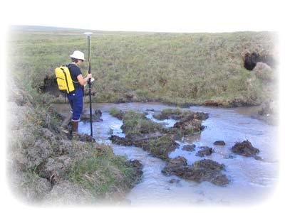
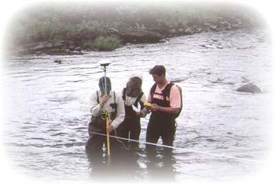
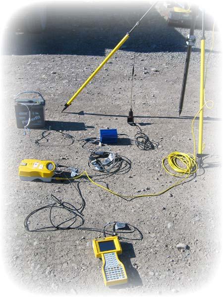
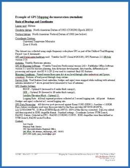
10 Example of GPS Mapping documentation (metadata) Basis of Bearings and Coordinates Linear unit: Meters Geodetic datum: North American Datum of 1983 (CORS96) Epoch Vertical datum: North American Vertical Datum of 1988 (see below) Coordinate System: Universal Transverse Mercator Zone 6 North This dataset was collected using single frequency code-phase GPS as part of the Chilkoot Trail Mapping Project <see X document>. GPS and DataLogger hardware used: Trimble GeoXT (Serial # ); GPS Firmware 2.11;Mobile version 5 OS Antenna: Trimble Hurricane antenna GPS & Mapping Software: <Trimble TerraSync Professional version 2.61>. Pathfinder Office Software version 3.1 used for mission planning, data dictionary development, data transfer, differential postprocessing and export. ArcGIS 9.1 (SP 2) was used to construct final GIS features. Mapping Conditions: Varied terrain from open sky at sea level through alder understory and Spruce overstory. Portions of trail passed through steep ravines. Survey Style: Trail features (trail centerline, bridges and signs) were mapped while walking with external antenna mounted at 7' above ground level (measured to base of antenna). GPS Quality Settings: HDOP - Optimal 4 (increased to 6 under thick canopy); SNR - Optimal 39 (lowered to 28 under thick canopy); Satellite Elevation Mask - Optimal 15. Logging Rate: All trail segment positions collected at 5 second logging rate. All point features (bridges and signs) collected at 1 second logging rate. GPS Data Processing: All data was post-processed against Kenai CORS (KEN1) - baseline ~ 110KM. Base station coordinates used were those provided by the Base provider (60 40' "N, ' "W, m (ITRF00-Epoch ). 100% of the file was corrected. Data was edited and then exported to ESRI shapefile format. Standard settings: Coordinate System: UTM Zone 6, NAD83. Datum: (Selected in PFO - NAD83 (CORS96) CONUS. ESRI shapefiles were then defined as UTM Zone 6, NAD83 in ArcToolbox. Contact: Joel Cusick National Park Service GIS Specialist/Alaska Regional Office 240 West. 5th Avenue, Anchorage, AK (907) joel_cusick@nps.gov Page 10 of 10
BUILDING AN ACCURATE GIS
 BUILDING AN ACCURATE GIS 2006 GIS in the Rockies Denver, Colorado September 13, 2006 William E. Linzey United States Department of Commerce National Oceanic and Atmospheric Administration National Geodetic
NATRF 2022 AND LDP OCTOBER 11, 2017
 NATRF 2022 AND LDP OCTOBER 11, 2017 MODERNIZATION OF THE NSRS Why? Leaving passive control marks behind and relying solely on the CORS network for 3D positions: Older methodology relies on terrestrial
Control Surveys and Coordinate Systems
 Control Surveys and Coordinate Systems The Earth is Round Basic Shape of the Earth: Oblate Spheroid of Revolution The length of the equatorial axis is approximately 27 miles greater than the polar axis.
4 Survey Datums. 4.1 Horizontal Datum Policy SURVEY DATUMS SEPTEMBER 2006
 4 Survey Datums Today s multi-organizational Project Development efforts require the use of common, accurate horizontal and vertical survey datums and consistent, precise control-survey procedures to ensure
MODERNIZATION OF THE NSRS
 NATRF 2022 AND LDP SEPTEMBER 12, 2017 MODERNIZATION OF THE NSRS Why? Leaving passive control marks behind and relying solely on the CORS network for 3D positions: Older methodology relies on terrestrial
Understanding Projections for GIS
 Presented by John Schaeffer Juniper GIS Services, Inc. This PowerPoint is available at JuniperGIS.com Presentation Objectives To understand basic concepts on projections and coordinate systems for the
This week s topics. Week 6. FE 257. GIS and Forest Engineering Applications. Week 6
 FE 257. GIS and Forest Engineering Applications Week 6 Week 6 Last week Chapter 8 Combining and splitting landscape features and merging GIS databases Chapter 11 Overlay processes Questions? Next week
Frames for the Future New Datum Definitions for Modernization of the U.S. National Spatial Reference System
 Figure 10. Horizontal position differences (in meters) between NAD 83 and ITRF 08 at time 2022.00 (January 1, 2022). Positional differences are shown for the North American and Pacific tectonic plates.
Intro to GIS Fall 2010 Georeferencing & Map Projections
 Intro to GIS Fall 2010 Georeferencing & Map Projections SHAPE OF THE EARTH Earth's Shape Geoid: shape of earth minus topographic features (irregular due to local variations in gravity) Ellipsoid: elongated
Georeferencing, Map Projections, Cartographic Concepts. -Coordinate Systems -Datum
 Georeferencing, Map Projections, Cartographic Concepts -Map Projections -Coordinate Systems -Datum Map projection is "the process of systematically transforming positions on the Earth's spherical surface
What is a Map Projection?
 What is a Map Projection? It is how we represent a three dimensional Earth on a flat piece of paper However The process of transferring information from the Earth to a map causes every projection to distort
Fusion of Geodesy and GIS at NOAA s National Geodetic Survey
 Fusion of Geodesy and GIS at NOAA s National Geodetic Survey Esri Survey Summit July 6-9, 2013 San Diego, CA Michael Dennis, RLS, PE michael.dennis@noaa.gov The Plan Background NGS Data Explorer New Datasheet
NGS and the Modernization of the National Spatial Reference System (NSRS)
") NGS and the Modernization of the National Spatial Reference System (NSRS) Dr. Dana Caccamise Pacific Southwest Region (CA,NV) Geodetic Advisor dana.caccamise@noaa.gov NOAA s National Geodetic Survey geodesy.noaa.gov
NGS and the Modernization of the National Spatial Reference System (NSRS) Dr. Dana Caccamise Pacific Southwest Region (CA,NV) Geodetic Advisor dana.caccamise@noaa.gov NOAA s National Geodetic Survey geodesy.noaa.gov
Achieving Great Height with GNSS
 Achieving Great Height with GNSS Oregon GPS Users Group 2015 Annual Meeting January 23, 2015 Salem, Oregon Salem Convention Center Michael Dennis, RLS, PE Oregon State University National Geodetic Survey
Ground Truth Annual Conference. Optimized Design of Low Distortion Projections. Michael L. Dennis, RLS, PE
 Arizona Professional Land Surveyors Association 016 Annual Conference Ground Truth Optimized Design of Low Distortion Projections Michael L. Dennis, RLS, PE Version 3 (rev 1), May 016 Design and metadata
VT State Plane. Daniel J. Martin National Geodetic Survey VT Geodetic Advisor. VSLS Conference Rutland VT April 11, 2008
 VT State Plane Daniel J. Martin National Geodetic Survey VT Geodetic Advisor VSLS Conference Rutland VT April 11, 2008 Today s Outline Define the problem Review of VT State Plane System Relationship
Town of Chino Valley. Survey Control Network Report. mgfneerhg mc N. Willow Creek Road Prescott AZ
 Town of Chino Valley Survey Control Network Report mgfneerhg mc. 2050 N. Willow Creek Road Prescott AZ 86301 928-771-2376 Page 1 of 70 Table of Contents Town of Chino Valley Survey Datum Outline A short
HORIZONTAL PROJECTION PARAMETERS: DANE COUNTY COORDINATES
 Recommended RTK GPS Configuration Parameters for the City of Madison, WI Base Station Compiled by: Dan Rodman RLS, City of Madison (608)266-6674 drodman@cityofmadison.com For base station information see
Ground Truth Annual Conference. Design and Documentation of Low Distortion Projections for Surveying and GIS
 Professional Land Surveyors of Oregon 15 Annual Conference Ground Truth Design and Documentation of Low Distortion Projections for Surveying and GIS Michael L Dennis, RLS, PE v. (rev 1), January 15, Design
Map projections. Rüdiger Gens
 Rüdiger Gens Coordinate systems Geographic coordinates f a: semi-major axis b: semi-minor axis Geographic latitude b Geodetic latitude a f: flattening = (a-b)/a Expresses as a fraction 1/f = about 300
REFERENCING COORDINATE SYSTEMS MAP PROJECTIONS GEOREFERENCING
 GIS in Ecology SPATIAL REFERENCING COORDINATE SYSTEMS MAP PROJECTIONS GEOREFERENCING : :1 Where on earth? Early mapmakers recognized the need for a system that could locate features on the earth's surface.
Geog Lecture 29 Mapping and GIS Continued
 Geog 1000 - Lecture 29 Mapping and GIS Continued http://scholar.ulethbridge.ca/chasmer/classes/ Today s Lecture (Pgs 13-25, 28-29) 1. Hand back Assignment 3 2. Review of Dr. Peddle s lecture last week
Boolean Operators and Topological OVERLAY FUNCTIONS IN GIS
 Boolean Operators and Topological OVERLAY FUNCTIONS IN GIS Query asking a question of the attribute data Standard Query Language (SQL) is used to query the data There are 4 basic statements used to get
The National Spatial Reference System of the Future
 The National Spatial Reference System of the Future William Stone Southwest Region (AZ, NM, NV, UT) Geodetic Advisor william.stone@noaa.gov NOAA s National Geodetic Survey geodesy.noaa.gov Salt Lake City
What is Geodesy? Types of Geodesy terrestrial or classical geodesy space geodesy theoretical geodesy
 What is Geodesy? Geodesy is the study of: The size, shape and motion of the earth The measurement of the position and motion of points on the earth's surface, and The study of the earth's gravity field
EnvSci360 Computer and Analytical Cartography
 EnvSci360 Computer and Analytical Cartography Lecture 3 Geodesy Map Projections, Datums, and Coordinate Systems 1 Geodesy The science of measuring and representing the shape and size of the earth, and
Georeferencing. Place names Postal addresses Postal codes Coordinate systems (lat/long, UTM, etc.)
") Georeferencing Georeferencing Used to describe the act of assigning locations to data or information Certain requirements include that they are: unique, have shared meaning, and are persistent through
Georeferencing Georeferencing Used to describe the act of assigning locations to data or information Certain requirements include that they are: unique, have shared meaning, and are persistent through
Lecture 4. Coordinate Systems & Projections
 Lecture 4 Coordinate Systems & Projections Outline Geodesy Geoids Ellipsoids Geographic Coordinate Systems Magnetic North vs. True North Datums Projections Applying Coordinate Systems and Projections Why
WHERE ARE YOU? Maps & Geospatial Concepts Fall 2012
 WHERE ARE YOU? Maps & Geospatial Concepts Fall 2012 Where are you? Relative location I m at school Absolute Location 45 26 18.07 122 43 50.78 Datums Datums A reference surface of the Earth Used as the
GRAVITY SURVEY TEELS MARSH PROSPECT
 GRAVITY SURVEY over the TEELS MARSH PROSPECT MINERAL COUNTY, NV for Dajin Resources (US) Corp. March 2015 SUBMITTED BY Magee Geophysical Services LLC 465 Leventina Canyon Road Reno, Nevada 89523 USA TEL
Making Sense of Evolving Reference Frames for North America
 Making Sense of Evolving Reference Frames for North America Mike Craymer Geodetic Survey Division, Natural Resources Canada Giovanni Sella U.S. National Geodesy Survey American Geophysical Union 2007 Joint
Introduction to Geographic Information Science. Updates/News. Last Lecture. Geography 4103 / Map Projections and Coordinate Systems
 Geography 4103 / 5103 Introduction to Geographic Information Science Map Projections and Coordinate Systems Updates/News Thursday s lecture Reading discussion 1 find the readings online open questions,
Lesson 5: Map Scale and Projections
 Organizing Data and Information Lesson 5: Map Scale and Projections Map Scales Projections Information can be organized as lists, numbers, tables, text, pictures, maps, or indexes. Clusters of information
NR402 GIS Applications in Natural Resources Lesson 4 Map Projections
 NR402 GIS Applications in Natural Resources Lesson 4 Map Projections From http://www.or.blm.gov/gis/ 1 Geographic coordinates Coordinates are expressed as Latitude and Longitude in Degrees, Minutes, Seconds
Modernization of the National Spatial Reference System 2022 Datum. Jacksonville Chapter July 2018
 Modernization of the National Spatial Reference System 2022 Datum Jacksonville Chapter July 2018 Randy Tompkins, PSM, PLS Geomatics Project Manager Surveyor, Hydrographer, & Geodesist DRMP, Inc. Jacksonville,
Geographic Information Systems class # 1 February 19, Coordinate reference systems in GIS: geodetic coordinates
 Geographic Information Systems class # 1 February 19, 2013 Coordinate reference systems in GIS: geodetic coordinates Manuel Campagnolo ISA Manuel Campagnolo (ISA) GIS/SIG 2012 2013 February 19, 2013 1
WHERE ARE YOU? Maps & Geospatial Concepts Fall 2015
 WHERE ARE YOU? Maps & Geospatial Concepts Fall 2015 Where are you? Relative location I m at school Absolute Location 45 26 18.07 122 43 50.78 Where is Boston? Introducing Geodesy, Ellipsoids & Geoids Geodesy
Preventing Coordinate- System Confusion (maybe?)
") Preventing Coordinate- System Confusion (maybe?) Montana Association of Registered Land Surveyors 2008 Convention Bozeman, Montana 07 & 08 February 2008 Glenn Borkenhagen Inland GPS Inc. - Cody, Wyoming
Preventing Coordinate- System Confusion (maybe?) Montana Association of Registered Land Surveyors 2008 Convention Bozeman, Montana 07 & 08 February 2008 Glenn Borkenhagen Inland GPS Inc. - Cody, Wyoming
GPS and Mean Sea Level in ESRI ArcPad
 Summary In order to record elevation values as accurately as possible with, it is necessary to understand how ArcPad records elevation. Rather than storing elevation values relative to Mean Sea Level (MSL),
Shape e o f f the e Earth
 1 Coordinate Systems & Projections Coordinate Systems Two map layers are not going to register spatially unless they are based on the same coordinate system. 2 Contents Shape of the earth Datum Projections
ch02.pdf chap2.pdf chap02.pdf
 Introduction to Geographic Information Systems 8th Edition Karl Solutions Manual Full Download: http://testbanklive.com/download/introduction-to-geographic-information-systems-8th-edition-karl-solutions-manu
MSGIC Spring Mtg Denton April 23, 2014
 Modernization of the National Spatial Reference System Keeping Pace with Changes in Positioning Technology and User Expectations in a Dynamic World MSGIC Spring Mtg Denton April 23, 2014 Dave Doyle Base
A PRIMER ON COORDINATE SYSTEMS Commonly Used in Michigan
 A PRIMER ON COORDINATE SYSTEMS Commonly Used in Michigan David P. Lusch, Ph.D., GISP Department of Geography Remote Sensing & GIS Research and Outreach Services Group Michigan State University September,
Lecture 2. Map Projections and GIS Coordinate Systems. Tomislav Sapic GIS Technologist Faculty of Natural Resources Management Lakehead University
 Lecture 2 Map Projections and GIS Coordinate Systems Tomislav Sapic GIS Technologist Faculty of Natural Resources Management Lakehead University Map Projections Map projections are mathematical formulas
Outline. Shape of the Earth. Geographic Coordinates (φ, λ, z) Ellipsoid or Spheroid Rotate an ellipse around an axis. Ellipse.
 Ellipsoid or Spheroid Rotate an ellipse around an axis. Ellipse.") Map Projections Outline Geodesy and map projections Prof. D. Nagesh Kumar Department of Civil Engineering Indian Institute of Science Bangalore 560 012, India http://www.civil.iisc.ernet.in/~nagesh Shape
Map Projections Outline Geodesy and map projections Prof. D. Nagesh Kumar Department of Civil Engineering Indian Institute of Science Bangalore 560 012, India http://www.civil.iisc.ernet.in/~nagesh Shape
Solving the "Grid to Ground Problem" with Custom Coordinate Systems CV327-6 About the Speaker:
 Solving the "Grid to Ground Problem" with Custom Coordinate Systems Richard Sincovec, LSI Director of Technology, Edward James Surveying President, Quux Software CV327-6 Grid projections such as the State
TOWARDS ROBUST LOCALIZATION OF RTK-GPS TOPOGRAPHIC SURVEYS 23
 TOWARDS ROBUST LOCALIZATION OF RTK-GPS TOPOGRAPHIC SURVEYS Jerry W. Nave, North Carolina A&T University; Tarig A. Ali, American University of Sharjah Abstract Localization is performed to fit the observed
GEOGRAPHIC COORDINATE SYSTEMS
 GEOGRAPHIC COORDINATE SYSTEMS Introduction to GIS Winter 2015 What is Georeferencing? Used to establish a location on the Earth s surface 1 st order polynomial transformation Georeferencing toolbar What
Geographic coordinate systems
 1 Geographic coordinate systems In this chapter you ll learn about longitude and latitude. You ll also learn about the parts that comprise a geographic coordinate system including Spheres and spheroids
Projections and Coordinate Systems
 Projections and Coordinate Systems Overview Projections Examples of different projections Coordinate systems Datums Projections Overview Projections and Coordinate Systems GIS must accurately represent
The 3-D Global Spatial Data Model: Geometrical Foundation of the Global Spatial Data Infrastructure
 The 3-D Global Spatial Data Model: Geometrical Foundation of the Global Spatial Data Infrastructure Earl F. Burkholder, PS, PE Annotated Table of Contents July 8,2006 I. The Global Spatial Data Model (GSDM)
12/26/2012. Geographic Information Systems * * * * GIS (... yrezaei
 ( - Geographic Information Systems ( ( 1 2 3 Information System Data base DB IS IS DB (Knowledge ( ( (System (Information System - (Georefrence Analysis Data + Knowledge ======== Information 4 5 ( < 10%
1/28/16. EGM101 Skills Toolbox. Oblate spheroid. The shape of the earth Co-ordinate systems Map projections. Geoid
 EGM101 Skills Toolbox Oblate spheroid The shape of the earth Co-ordinate systems Map projections The geoid is the shape that the surface of the oceans would take under the influence of Earth's gravitation
Projections & GIS Data Collection: An Overview
 Projections & GIS Data Collection: An Overview Projections Primary data capture Secondary data capture Data transfer Capturing attribute data Managing a data capture project Geodesy Basics for Geospatial
GEOIDS FAQ. November
 GEOIDS FAQ 1. What is a geoid? A geoid is a representation of the equipotential surface of the Earth s gravity field. It can be thought of as a surface coinciding with the undisturbed mean sea level extended
Basic Geodetics What Every GIS User Should Know
 Experts in Geomatics, Surveying, Positioning, Geospatial Data, and Mapping Sciences Basic Geodetics What Every GIS User Should Know Michael Barnes Cain & Barnes LP michael.barnes@cain-barnes.com Steven
CHAIRMAN OF THE JOINT CHIEFS OF STAFF INSTRUCTION
 CHAIRMAN OF THE JOINT CHIEFS OF STAFF INSTRUCTION J-3 CJCSI 3900.01C DISTRIBUTION: A, B, C, J POSITION (POINT AND AREA) REFERENCE PROCEDURES Reference: DODD 5105.60, 11 October 1996, National Imagery and
GISC3325 Spring 2011 Final Exam
 GISC3325 Spring 2011 Final Exam Name: Carefully read each question. Identify the important elements and the question being asked. Show your work for partial credit. No credit for undocumented wrong answers.
When the Earth Was Flat. Measurements were made using a plumb bob, a spirit level, and a stick. Also, the Stars.
 ABSTRACT Defining the shape of the Earth geoid. Mathematical models spheroid or ellipsoid Mathematical projection of geodetic systems GIS/GPS technology The need for a unified projection systems World
Analytical and Computer Cartography Lecture 3: Review: Coordinate Systems
 Analytical and Computer Cartography Lecture 3: Review: Coordinate Systems Geographic Coordinates NAD83 NAD27 remained in use until the earthcentered international GRS80 was complete (Geodetic Reference
Coordinate Systems. Location on earth is defined by coordinates
 Coordinate Systems We think of the earth as a sphere It is actually a spheroid (ellipsoid), slightly larger in radius at the equator than at the poles Shape of the Earth Location on earth is defined by
KEYSTONE PROPERTY GRAVITY GIS DATABASE. Residual Gravity Looking Down to Northwest
 KEYSTONE PROPERTY GRAVITY - 2018 GIS DATABASE Residual Gravity Looking Down to Northwest James L. Wright M.Sc. May 11, 2018 TABLE OF CONTENTS INTRODUCTION......................... 2 SURVEY PROCEDURE......................
Map Projections. What does the world look like? AITOFF AZIMUTHAL EQUIDISTANT BEHRMANN EQUAL AREA CYLINDRICAL
 Map Projections What does the world look like? AITOFF AZIMUTHAL EQUIDISTANT BEHRMANN EQUAL AREA CYLINDRICAL 1 CYLINDRICAL EQUAL AREA BONNE CRASTER PARABOLIC 2 ECKERT I ECKERT III ECKERT V There are many
This Land Surveying course has been developed by Failure & Damage Analysis, Inc.
 This Land Surveying course has been developed by Failure & Damage Analysis, Inc. www.discountpdh.com DEPARTMENT OF THE ARMY U.S. Army Corps of Engineers CECW-EP Washington, DC 20314-1000 ETL 1110-1-183
Geospatial Data Standards Considerations for the delivery of 2D and 3D spatial data February 2019
 Geospatial Data Standards Considerations for the delivery of 2D and 3D spatial data February 2019 Prepared by: GRCA Geomatics Version Date Summary of Changes Changes Made By: 1.00 March 16, 2018 Version
Height Modernization 2013 A New Canadian Vertical Datum
 Height Modernization 2013 A New Canadian Vertical Datum What is Height Modernization? The Height Reference System Modernization is a project at the Geodetic Survey Division (GSD) of Natural Resources Canada
IDENTIFYING THE TYPE OF COORDINATE SYSTEM FOR DATA USING ARCMAP
 CHAPTER 1 IDENTIFYING THE TYPE OF COORDINATE SYSTEM FOR DATA USING ARCMAP I got a parcel shapefile from the county, but it doesn t line up with my other data in ArcMap. My boss told me to make a map using
The Elements of GIS. Organizing Data and Information. The GIS Database. MAP and ATRIBUTE INFORMATION
 GIS s Roots in Cartography Getting Started With GIS Chapter 2 Dursun Z. Seker MAP and ATRIBUTE INFORMATION Data (numbers and text) store as files refer to them collectively as a database gather inform.
Approaches to GNSS & Geodesy
 Approaches to GNSS & Geodesy Ray Hintz Univ. of Maine Ray.hintz@.maine.edu The biggest complaint about state plane coordinates The concept that scale and elevation factor need to be applied to the pythagoreum
Lecture 10-14: Map Projections and Coordinate System
 URP 1281 Surveying and Cartography Lecture 10-14: Map Projections and Coordinate System December 27, 2015 Course Teacher: Md. Esraz-Ul-Zannat Assistant Professor Department of Urban and Regional Planning
ELECTRONICS DIVISION INTERNAL REPORT NO. 324
 NATIONAL RADIO ASTRONOMY OBSERVATORY Green Bank, West Virginia ELECTRONICS DIVISION INTERNAL REPORT NO. 324 NRAO 43m Antenna Coordinates and Angular Limits (Version 4) Glen Langston September 14, 2012
Coordinate Systems and Datum Transformation in ArcGIS. Brittney White and Melita Kennedy
 Coordinate Systems and Datum Transformation in ArcGIS Brittney White and Melita Kennedy Where is my data? Problem Horizontal Vertical Projections Transformations Horizontal coordinate systems Geographic
Welcome to Lesson 4. It is important for a GIS analyst to have a thorough understanding of map projections and coordinate systems.
 Welcome to Lesson 4. It is important for a GIS analyst to have a thorough understanding of map projections and coordinate systems. A GIS without coordinates would simply be a database like Microsoft Excel
Meeting the ODOT Survey & Mapping Specifications
 Meeting the ODOT Survey & Mapping Specifications A Simple Solution Presented by Ray Foos, P.S, ODOT CADD & Mapping Services & Jon Keller, P.S., ODOT District 3 Phases of an ODOT Survey Project Research
Dr. ABOLGHASEM AKBARI Faculty of Civil Engineering & Earth Resources, University Malaysia Pahang (UMP)
") Workshop on : Dr. ABOLGHASEM AKBARI Faculty of Civil Engineering & Earth Resources, University Malaysia Pahang (UMP) 14-15 April 2016 Venue: Tehran, Iran GIS definitions GIS: A simplified view of the real
Workshop on : Dr. ABOLGHASEM AKBARI Faculty of Civil Engineering & Earth Resources, University Malaysia Pahang (UMP) 14-15 April 2016 Venue: Tehran, Iran GIS definitions GIS: A simplified view of the real
Shape of the Earth. Data Output by the Receiver
 It is quite common for confusion to arise about the process used during a hydrographic survey when GPS-derived water surface elevation is incorporated into the data as an RTK Tide correction. This article
2. GETTING STARTED WITH GIS
 2. GETTING STARTED WITH GIS What are geographic information systems and what are they used for? ArcGIS: ArcMap, ArcCatalog and ArcToolbox Vector data vs. raster data vs. attribute tables Polygons, polylines,
Changes are coming NGS NSRS Modernization Are you Ready?
 Changes are coming NGS 2022 - NSRS Modernization Are you Ready? Pam Fromhertz Rocky Mountain Regional Advisor Pamela.Fromhertz@noaa.gov 240-988-6363 John Hunter CO State Geomatics Coordinator DRCOG March
Height systems. Rudi Gens Alaska Satellite Facility
 Rudi Gens Alaska Satellite Facility Outline Why bother about height systems? Relevant terms Coordinate systems Reference surfaces Geopotential number 2 Why bother about height systems? give a meaning to
The Wildlife Society Meet and Greet. Come learn about what the UNBC Student Chapter of TWS is all about!
 Georeferencing I GEOG 300, Lecture 4 Dr. Anthony Jjumba 1 The Wildlife Society Meet and Greet Quiz Come learn about what the UNBC Student Chapter of TWS is all about! 5:30 7:30 PM, Wednesday September
New Datums: Replacing NAVD 88 and NAD 83
 New Datums: Replacing NAVD 88 and NAD 83 By Dave Zenk PE, LS National Geodetic Survey Northern Plains Regional Advisor 1735 Lake Drive West Chanhassen, MN 55317-8581 952-368-2548 office 612-414-9522 mobile
Geo Referencing & Map projections CGI-GIRS 0910
 Geo Referencing & Map projections CGI-GIRS 0910 Where are you? 31UFT8361 174,7 441,2 51 58' NB 5 40' OL 2/60 Who are they? 3/60 Do geo data describe Earth s phenomena perfectly? Georeference systems ellipsoid
U.S. Datums: Where We ve Been,
 U.S. Datums: Where We ve Been, Where We re Going Modernizing the National Spatial Reference System Matt Wellslager RFA, South Carolina Geodetic Survey Presentation Outline 1. - Introductions. 2. - National
Importance of Understanding Coordinate Systems and Map Projections.
 Importance of Understanding Coordinate Systems and Map Projections. 1 It is extremely important that you gain an understanding of coordinate systems and map projections. GIS works with spatial data, and,
Evaluation of GPS in Orthometric Heights Determination in Khartoum State (Sudan)
") Evaluation of GPS in Orthometric Heights Determination in Khartoum State (Sudan) Dr. Nagi Zomrawi Mohammed 1, Dr. Abd Elrahim Elgizouli Mohammed 2 and Engineer Osman Bakry 3 1 Sudan University of Science
Evaluation of GPS in Orthometric Heights Determination in Khartoum State (Sudan) Dr. Nagi Zomrawi Mohammed 1, Dr. Abd Elrahim Elgizouli Mohammed 2 and Engineer Osman Bakry 3 1 Sudan University of Science
Geo Referencing & Map projections CGI-GIRS 0910
 Geo Referencing & Map projections CGI-GIRS 0910 Where are you? 31UFT8361 174,7 441,2 51 58' NB 5 40' OL 2/60 Who are they? 3/60 Do geo data describe Earth s phenomena perfectly? Georeference systems ellipsoid
Mobile Mapping Tips and Tricks
 Mobile Mapping Tips and Tricks Projections, Datums and Geoids, May 2017 Introduction This guide is designed to provide a basic understanding of coordinate system projections, datums and geoids. The guide
LEADS. The Essential Elements of a 3-D Geographic Coordinate
 The Essential Elements of a 3-D Geographic Coordinate John W. Dix 13 September 2005 ESRI Homeland Security GIS Summit - Denver, CO John.W.Dix@nga.mil NATIONAL GEOSPATIAL-INTELLIGENCE AGENCY Overview is
How does an ellipsoid differ from a sphere in approximating the shape and size of the Earth?
 Chapter 02 Test Bank Worksheet Questions 1. What is a map projection? Topic: Map Projection 2. How does an ellipsoid differ from a sphere in approximating the shape and size of the Earth? Topic: Ellipsoid
Using UNAVCO Real-Time CORS Data, a No-Cost Positioning Resource
 Using UNAVCO Real-Time CORS Data, a No-Cost Positioning Resource By: Mark Silver, ms@igage.com, +1-801-412-0011 Date: 19 August 2014 UNAVCO is a non-profit consortium of Universities that coordinates the
This presentation covers the following areas
 Geodetic Datums and Coordinate Systems for Surveying and Mapping in Hong Kong FIG Working Week 2012 Rome, Italy 6-10 May Simon KWOK Hong Kong, China 1 This presentation covers the following areas Explains
Geodetics: Implications for GIS Professionals May 10, 2018
 Experts in Geomatics, Surveying, Positioning, Geospatial Data, and Mapping Sciences Geodetics: Implications for GIS Professionals May 10, 2018 Michael Barnes APSG Education Foundation Chair 2010-2020 APSG
MobileMapper 6. White Paper. MobileMapper 6 vs. Juno SC In Real World Conditions. Sub-Meter, Post-Processed Accuracy for less than 1,500 USD
 MobileMapper 6 White Paper MobileMapper 6 vs. Juno SC In Real World Conditions Sub-Meter, Post-Processed Accuracy for less than 1,500 USD Table of Contents Introduction...1 Testing Methodology...2 Test
GEOID UNDULATIONS OF SUDAN USING ORTHOMETRIC HEIGHTS COMPARED WITH THE EGM96 ANG EGM2008
 GEOID UNDULATIONS OF SUDAN USING ORTHOMETRIC HEIGHTS COMPARED Dr. Abdelrahim Elgizouli Mohamed Ahmed* WITH THE EGM96 ANG EGM2008 Abstract: Positioning by satellite system determine the normal height above
Laboratory Topic 4: Projections and Geo-Positioning in ArcGIS [ LAEP/GEOG c188 ]
![Laboratory Topic 4: Projections and Geo-Positioning in ArcGIS [ LAEP/GEOG c188 ]](/thumbs/81/82687491.jpg "Laboratory Topic 4: Projections and Geo-Positioning in ArcGIS [ LAEP/GEOG c188 ]") Laboratory Topic 4: Projections and Geo-Positioning in ArcGIS 10.4.1 - [ LAEP/GEOG c188 ] Projections in ArcGIS 10.4.1 In this tutorial you will learn to identify the Projection and Datum of a dataset,
Laboratory Topic 4: Projections and Geo-Positioning in ArcGIS 10.4.1 - [ LAEP/GEOG c188 ] Projections in ArcGIS 10.4.1 In this tutorial you will learn to identify the Projection and Datum of a dataset,
Coordinate systems, measured surveys for BIM, total station for BIM, as-built surveys, setting-out
 Coordinate systems, measured surveys for BIM, total station for BIM, as-built surveys, setting-out What is a BIM What does a BIM do Why use a BIM BIM Software BIM and the Surveyor How do they relate to
GPS Surveying Dr. Jayanta Kumar Ghosh Department of Civil Engineering Indian Institute of Technology, Roorkee. Lecture 06 GPS Position
 GPS Surveying Dr. Jayanta Kumar Ghosh Department of Civil Engineering Indian Institute of Technology, Roorkee Lecture 06 GPS Position Friends! Welcome you to sixth class on GPS surveying. Today, I am going
Geocentric Datum of Australia - GDA
 Geocentric Datum of Australia - GDA Supporting GDA94 ARC/INFO 7.2.1 ArcView 3.1 An ESRI Australia White Paper September 1999 White Paper Series OVERVIEW... 1 INTRODUCTION... 1 PART 1 ESRI SOLUTION... 2
Positional Accuracy of the Google Earth Imagery In The Gaza Strip
 Positional Accuracy of the Google Earth Imagery In The Gaza Strip Maher A. El-Hallaq Associate Professor of Surveying Civil Engineering Department The Islamic University of Gaza, Palestine mhallaq@iugaza.edu.ps
GIST 3300 / Geographic Information Systems. Last Time. Today
 GIST 3300 / 5300 Last Time Ellipsoids and Datums Today Map Projections Map Projections Today we will build on the concepts of Geographic Coordinate Systems, Ellipsoids and Datums and add the concepts of