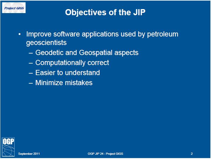
Basic Geodetics What Every GIS User Should Know
|
|
|
- Adelia Alexander
- 5 years ago
- Views:
Transcription

1 Experts in Geomatics, Surveying, Positioning, Geospatial Data, and Mapping Sciences Basic Geodetics What Every GIS User Should Know Michael Barnes Cain & Barnes LP Steven Long Shell May 9, 2013
2 Knowledge Data Zone of the Geodetic Quagmire Techniques Tools Source: Cain & Barnes LP 2
3 Knowledge Basic Geography College, University Industry Training Learning & Development Data Basic Geodetics Techniques Tools 3
4 The least you need to know for Geospatial Data Management Geodetic Awareness of 5 Facts: 1. Geodetic Datum 2. Map Projection 3. Vertical Reference 4. Reference Orientation 5. Unit of Measurement 4
 Source:")
5 Geodetic Reference Surfaces h H N Normal to Ellipsoid Normal to Geoid N=h-H Ellipsoid Geoid Terrain b a Geoid Equipotential surface which approximates to MSL Ellipsoid Surface where Computations are made 1/f = a/(a-b) Source: APSG 5


6 Examples of Geodetic Datums 6

7 How many geodetic datums? Review 7

8 Before GPS we had 150 years of geodetic surveying e.g. National Geodetic Survey of Nepal
9 Hierarchy of Mapping Ellipsoid λp Equator Yp Φp hp P Zp Xp Projected CRS is a derivative of the Datum (Geog CRS) Easting, Northing, Elevation (above MSL) stable Unstable w/o Datum Datum (ellipsoid & origin) is the Foundation X,Y,Z Cartesian and Lat, Long, Ht Source: APSG 9

10 What are the main map projections in use? Mercator Transverse Mercator Universal Transverse Mercator Lambert Conformal Conic Others less frequently: Stereographic, Oblique Stereographic, Oblique Mercator, et. al. 10
11 Vertical Reference: Height, elevation, vertical datum or what? Local Kelly-Bushing, ground level, sea level, and assorted other local references Geodetic Either directly or derived from Mean Sea Level at one or more points at some epoch examples: NGVD 29, NAVD 88, IGLD85, OSU91A, EGM96, EGM2008 Tidal Defined by direct observation of tidal variations over some period of time at a specific location (or locations) examples: MSL, LAT, MLLW, MLW, MHW, MHHW 11
12 Potential for confusion with Local Vertical Datum Source: UKOAA, now OGP 12
13 13
14 Reference Orientations (5 kinds of north) True North = Direction of the meridian through a point Magnetic North = Differs from True North by declination and varies with time Grid North = Differs from True North by convergence Gyro North = a measurement of True North by instrument Plant North = strictly a local non-georeferenced orientation 14
15 Units of Measurement (13 kinds of feet and 2 kinds of meters in use) Reference Units: Biggest E&P Problem US Survey Foot vs. International Foot 1 ftus = ft (Intl), but this is still important for UTM, generating foot errors, depending on latitude Other Feet: Clarke s Foot, Sears 1922, 2 for Benoit (both 1895), Gold Coast Ft., 4 Indian Ft. (1865, 1937, 1962 & 1975) and 2 British Feet (1865 & 1935), 2 meters: International Meter and German Legal Meter Other linear units include Chains, Links, and Yards 15
16 If you remember nothing else.. Latitudes and Longitudes are not unique unless qualified with datum name Projection Coordinates are not unique unless qualified with Projection name, Zone and Datum Heights are not unique unless qualified with Surface Reference (Vertical Datum) Orientations are not unique unless qualified with Heading Reference Units are not unique unless qualified with Unit Reference 16

17 Knowledge Basic Geography College, University Industry Training Learning & Development Data Acquisition & Sourcing Processing & Integration Integrity & Handling Data basing & Retrieval Basic Geodetics Techniques Tools 17
18 Corporate Geospatial Data Managed at global or business unit level Company Propriety data Lease boundaries and licensed areas Seismic Well data Topographic and bathymetry Site survey and environmental data Infrastructure (pipelines, platforms, cables..) Third party industry data Seismic Well database Geologic data High resolution satellite imagery Gravity and magnetics 18

19 Past, Present, and Future Geodetic Integrity of Geospatial Data requires Source: OGP GIGS 19


20 Fundamental Exploration Data Sets Seismic surveys Wells, surface and well bore locations Boundaries, lease and license areas 20

21 Source: OGP 21
22 Source: OGP 22


23 80% + of all GG&E data Easting and Northing, X and Y or Y and X? Units of Measure stated? e.g. US Survey Foot International Foot Meter, etc Mandatory Metadata 23

24 NAD83 Seismic Survey incorrectly mapped as NAD feet of error as a block shift 24

25 Commercial Well Location Data Source: APSG 25
 Source:")
26 Digital Land Grids (Cadastral) Source: APSG 26

27 Area Discrepancy due to Incorrect Grid 27

28 Example Unit with Discrepancies Measured 28

29 Various State & Vendor Database Well Locations 29

30 Source: Conner 30

31 Source: Conner 31
32 Reasons for Mislocation of Wells Accuracy and reliability of original measurement systems and cartographic layers Miscalculations and poor QC Error in transformation of Coordinate Reference Systems Transcription errors, data entered incorrectly Transposing legacy data via new technologies Inadequate documentation Lack of industry standards for surveying and mapping 32


33 Well Surface Locations are frequently wrong Source: EnSoCo 33

34 34
35 Innovations in data use still requires sound geodetic and mapping principles 35

36 This image cannot currently be displayed. Time Lapse Plant refurbishment Iraq 7 months of overlay data 36
37 Geo-Information Integration 2010 DEM 2006 photography 1964 Surficial Geology 1968 topo 2012 topo 2012 aerial 37
38 Seismic Project, Wyoming Twenty Four 2D Data Geodetic Parameters Options NAD27 NAD83 WGS84 NAD27 / BLM 12N (ftus) NAD27 / BLM 13N (ftus) NAD27 / UTM zone 12N NAD27 / UTM zone 13N NAD27 / Wyoming West NAD83 / BLM 12N (ftus) NAD83 / BLM 13N (ftus) NAD83 / UTM zone 12N NAD83 / UTM zone 13N NAD83 / Wyoming West NAD83 / Wyoming West (ftus) NAD83(HARN) / UTM zone 12N NAD83(HARN) / UTM zone 13N NAD83(HARN) / Wyoming West NAD83(HARN) / Wyoming West (ftus) NAD83(NSRS2007) / UTM zone 12N NAD83(NSRS2007) / UTM zone 13N NAD83(NSRS2007) / Wyoming West NAD83(NSRS2007) / Wyoming West (ftus) SPCS83 Wyoming West zone (meters) SPCS83 Wyoming West zone (US Survey feet) 38
39 CRS Metadata inadequate? What is mislocation risk? NAD27 NAD83 WGS84 NAD27 / BLM 12N (ftus) NAD27 / BLM 13N (ftus) NAD27 / UTM zone 12N NAD27 / UTM zone 13N NAD27 / Wyoming West NAD83 / BLM 12N (ftus) NAD83 / BLM 13N (ftus) NAD83 / UTM zone 12N NAD83 / UTM zone 13N NAD83 / Wyoming West NAD83 / Wyoming West (ftus) NAD83(HARN) / UTM zone 12N NAD83(HARN) / UTM zone 13N NAD83(HARN) / Wyoming West NAD83(HARN) / Wyoming West (ftus) NAD83(NSRS2007) / UTM zone 12N NAD83(NSRS2007) / UTM zone 13N NAD83(NSRS2007) / Wyoming West NAD83(NSRS2007) / Wyoming West (ftus) SPCS83 Wyoming West zone (meters) SPCS83 Wyoming West zone (US Survey feet) 39
 Project Working West Wyoming Data on Vacation Nebraska State Park")
40 Same X,Y numbers used with different map projections NAD27 / Wyoming West or NAD83 / Wyoming West (ftus) Project Working West Wyoming Data on Vacation Nebraska State Park 40
41 Geo-Information Integration? Project GIS had 168 spatial layer 41

42 3D printing direct from GIS data 42

43 OGP ESPG Area Polygons reducing risk in handling of geodetic data 2,900+ polygons available online Source: OGP 43

44 Example: Nigeria Onshore and EEZ Rectangular Bounding Box 11 geodetic datums 13 Projected CRS* 25 transformations Geographic Area Polygon 3 geodetic datums 9 Projected CRS* 13 transformations * = datum + map projection 44

45 45


46 Knowledge Basic Geography College, University Industry Training Learning & Development Data Acquisition & Sourcing Processing & Integration Integrity & Handling Data basing & Retrieval Basic Geodetics Techniques Tools GNSS (GPS) Positioning GIS Mapping Geoscience Software Engineering Software Source: Cain & Barnes LP 46

47 Source: Schostak 47

48 48
49 49
50 50
51 51
52 52


53 Geospatial Integrity Compliance Grade????

 Positioning GIS Mapping Geoscience Software Engineering")
54 Data Acquisition & Sourcing Processing & Integration Integrity & Handling Data basing & Retrieval Basic Geodetics Techniques Standards & Practices Procedures & Workflows Quality Control Processes Continuous Improvement Tools GNSS (GPS) Positioning GIS Mapping Geoscience Software Engineering Software 54
55 Forensic Geodetics of Well Location (US GOM) Followed the data from G&G through Drilling Operations 486 documents with well location stated Location stated as X and Y Often stated as UTM 16N ftus (aka BLM) NAD 27 and NAD 83 both are relevant 40% had no datum stated Geoscience data handling in UTM 15 and 16 at various stages of process Positioning difference is. Cost of the well is 55

56 NAD27 / UTM 15N vs. NAD83 / UTM 15N Positioning difference is 656 feet Cost of Well US$ 85 million 56

57 Transforming Coordinate Reference Systems Concatenated data operations are not trivial Source: OGP EPSG Registry 57
58 Knowledge Basic Geography College, University Industry Training Learning & Development Data Basic Geodetics Techniques Tools 58
59 59
60 Demographics of Participants

61 Relevant and Useful?
62 Data Tools Zone of the Geodetics Quagmire Knowledge Techniques 62
63 Agenda Defining a GIS Project Working in ArcMap Dissemination of Geo-Information Summary
64 Overview GIS Project Setup What is my area of interest? How do I determine valid coordinate reference systems for my area of interest? What is the preferred coordinate reference system? Working in ArcMap What happens when I import my data into ArcMap? What is the preferred transformation? What is the maximum error if incorrect transformation is selected? Dissemination of Geo- Information Web Maps 3D Viewers Map Products Potential for geodetic integrity issues at all stages
65 Agenda Defining a GIS Project Working in ArcMap Dissemination of Geo-Information Summary
 Ensure CRS")
 Users should not make assumptions")
66 GIS Project Lifecycle Mandatory Coordinate Reference System (CRS) definition at project framing phase Coordinate Reference Systems (CRS) Ensure CRS validation for all subsurface applications Geomatics experts contacted at project start-up Source: McLay (2007) Users should not make assumptions regarding CRS!

67 Determining Coordinate Reference System OGP EPSG Area Polygons Reduces risk in handling of geodetic data polygons available online Source: OGP

68 OGP EPSG Area Polygons Download shapefile and load directly into ArcMap Area of Interest

69 EPSG Geodetic Parameter Registry Structured dataset of Coordinate Reference Systems and Coordinate Transformations Options to query by filter or retrieve by code Source: OGP


70 EPSG Geodetic Parameter Registry (con t) Source: OGP
71 Recommendations for CRS Selection Select an appropriate 2D geographic CRS ( datum ) which is in common use and has an accepted and well defined transformation to WGS 84 Use an appropriate map projection that is in common use and has small distortions Consider existing legacy data Consider export of produced data / maps (i.e., regulatory reporting requirements) Objective is to minimize geodetic risk Obvious choice is not always the best
72 Agenda Defining a GIS Project Working in ArcMap Dissemination of Geo-Information Summary
73 Geodetic Integrity and ArcGIS ArcMap has the ability to transform and re-project on the fly Can display data stored in one CRS as if it were in another, without altering the actual data Data frame s CRS is defined by the first layer added to the data frame or by manually setting the CRS through the data frame properties But there is no help to the user for the selection of the preferred transformation

74 Transformations When To Use A transformation is required when changing coordinates from one CRS to another CRS (i.e., NAD27 to WGS 84) Transform? No Transformation Required Source CRS: NAD27 Target CRS: NAD27 Transform? Transformation Required Source CRS: NAD27 Target CRS: WGS 84

75 Out-of-the-box ArcGIS Transformation No information about what are the differences between these transformations Which one is the preferred transformation?

76 Custom Transformations Users have the ability to create custom transformations Consult your local geodetic expert!
 NADCON - Alaska NTv2 NADCON -")
77 North American Preferred Transformations Transformations from NAD27 to NAD83 (WGS 84) NADCON - Alaska NTv2 NADCON - Conus

78 Difference Between NAD27 and NAD83 Source: Wikipedia
79 Agenda Defining a GIS Project Working in ArcMap Dissemination of Geo-Information Summary
 Do you know the coordinate reference system of your input dataset? 3) Do you know what transformation is being used between the application and the input datum? Source: ESRI http://www.arcgis.")
80 Web Maps Increasingly popular medium for displaying spatial information Uses internet browser Questions: 1) Do you know what coordinate reference system is being used by the application? 2) Do you know the coordinate reference system of your input dataset? 3) Do you know what transformation is being used between the application and the input datum? Source: ESRI Beware of your input data properties and data operations performed by application
")
 Better integration with GIS data Uses WGS 84 as CRS Should only be used for small / medium scale mapping NADCON not supported")
81 3D Viewers ArcGIS Explorer and Google Earth Both allow input and display of GIS data How is this data handled? ArcGIS Explorer (Build 1750) Google Earth Pro (version ) Better integration with GIS data Uses WGS 84 as CRS Should only be used for small / medium scale mapping NADCON not supported Can consume shapefiles Uses WGS 84 as CRS Fitting of images of different types causes some of the images to be distorted. How much? Not advisable to do large scale digitization from images Need to transform input datum into WGS 84
82 Map Products All maps should have the coordinate reference system as the minimum; Name and EPSG code EPSG code is standard for oil and gas industry Example EPSG Name: NAD27 / BLM 15N (ftus) EPSG Code: ESRI names are not EPSG compliant Look up codes in EPSG Geodetic Parameter Registry
83 Summary Don t make assumptions regarding coordinate reference systems Don t assume the software sorts out your geodetic problems Make use of OGP EPSG polygons and EPSG geodetic parameter registry Seek advice from geodetic experts when in doubt


84 More than 460 experts in Geomatics, Geodetics, Surveying, Positioning and Navigation, Geospatial Data, and Mapping Sciences Apply online to join for professional development, technical education, business networking, and fellowship
Geodetic Integrity The Essential for Data Managers and Users March 13, 2013, Houston
 Experts in Geomatics, Surveying, Positioning, Geospatial Data, and Mapping Sciences Geodetic Integrity The Essential for Data Managers and Users March 13, 2013, Houston Michael Barnes APSG Foundation Chair
Geodetics: Implications for GIS Professionals May 10, 2018
 Experts in Geomatics, Surveying, Positioning, Geospatial Data, and Mapping Sciences Geodetics: Implications for GIS Professionals May 10, 2018 Michael Barnes APSG Education Foundation Chair 2010-2020 APSG
PPDM Data Management Symposium March 7, 2012 Houston
 Experts in Geomatics, Surveying, Positioning, Geospatial Data, and Mapping Sciences PPDM Data Management Symposium March 7, 2012 Houston Michael Barnes APSG Foundation Chair 2010-2015 APSG Chair 2008-2009
BUILDING AN ACCURATE GIS
 BUILDING AN ACCURATE GIS 2006 GIS in the Rockies Denver, Colorado September 13, 2006 William E. Linzey United States Department of Commerce National Oceanic and Atmospheric Administration National Geodetic
This week s topics. Week 6. FE 257. GIS and Forest Engineering Applications. Week 6
 FE 257. GIS and Forest Engineering Applications Week 6 Week 6 Last week Chapter 8 Combining and splitting landscape features and merging GIS databases Chapter 11 Overlay processes Questions? Next week
Intro to GIS Fall 2010 Georeferencing & Map Projections
 Intro to GIS Fall 2010 Georeferencing & Map Projections SHAPE OF THE EARTH Earth's Shape Geoid: shape of earth minus topographic features (irregular due to local variations in gravity) Ellipsoid: elongated
Geospatial Data Standards Considerations for the delivery of 2D and 3D spatial data February 2019
 Geospatial Data Standards Considerations for the delivery of 2D and 3D spatial data February 2019 Prepared by: GRCA Geomatics Version Date Summary of Changes Changes Made By: 1.00 March 16, 2018 Version
Connecting the Dots. A Model for Enterprise Wide Excellence in Spatial Data Management
 Connecting the Dots A Model for Enterprise Wide Excellence in Spatial Management IHS Users Group Presentation Finding and producing hydrocarbons Mapping Sciences Making and Communicating with Maps Sources
Overview key concepts and terms (based on the textbook Chang 2006 and the practical manual)
") Introduction Geo-information Science (GRS-10306) Overview key concepts and terms (based on the textbook 2006 and the practical manual) Introduction Chapter 1 Geographic information system (GIS) Geographically
Introduction Geo-information Science (GRS-10306) Overview key concepts and terms (based on the textbook 2006 and the practical manual) Introduction Chapter 1 Geographic information system (GIS) Geographically
Coordinate Systems and Datum Transformation in ArcGIS. Brittney White and Melita Kennedy
 Coordinate Systems and Datum Transformation in ArcGIS Brittney White and Melita Kennedy Where is my data? Problem Horizontal Vertical Projections Transformations Horizontal coordinate systems Geographic
EnvSci360 Computer and Analytical Cartography
 EnvSci360 Computer and Analytical Cartography Lecture 3 Geodesy Map Projections, Datums, and Coordinate Systems 1 Geodesy The science of measuring and representing the shape and size of the earth, and
Introduction to Geographic Information Science. Updates/News. Last Lecture. Geography 4103 / Map Projections and Coordinate Systems
 Geography 4103 / 5103 Introduction to Geographic Information Science Map Projections and Coordinate Systems Updates/News Thursday s lecture Reading discussion 1 find the readings online open questions,
What is a Map Projection?
 What is a Map Projection? It is how we represent a three dimensional Earth on a flat piece of paper However The process of transferring information from the Earth to a map causes every projection to distort
12/26/2012. Geographic Information Systems * * * * GIS (... yrezaei
 ( - Geographic Information Systems ( ( 1 2 3 Information System Data base DB IS IS DB (Knowledge ( ( (System (Information System - (Georefrence Analysis Data + Knowledge ======== Information 4 5 ( < 10%
You might know your position precisely but do you know where you are?
 You might know your position precisely but do you know where you are? Whosoever wishes to know about the world must learn about it in its particular details. The possession of knowledge does not kill the
Solving the "Grid to Ground Problem" with Custom Coordinate Systems CV327-6 About the Speaker:
 Solving the "Grid to Ground Problem" with Custom Coordinate Systems Richard Sincovec, LSI Director of Technology, Edward James Surveying President, Quux Software CV327-6 Grid projections such as the State
ch02.pdf chap2.pdf chap02.pdf
 Introduction to Geographic Information Systems 8th Edition Karl Solutions Manual Full Download: http://testbanklive.com/download/introduction-to-geographic-information-systems-8th-edition-karl-solutions-manu
How does an ellipsoid differ from a sphere in approximating the shape and size of the Earth?
 Chapter 02 Test Bank Worksheet Questions 1. What is a map projection? Topic: Map Projection 2. How does an ellipsoid differ from a sphere in approximating the shape and size of the Earth? Topic: Ellipsoid
Map projections. Rüdiger Gens
 Rüdiger Gens Coordinate systems Geographic coordinates f a: semi-major axis b: semi-minor axis Geographic latitude b Geodetic latitude a f: flattening = (a-b)/a Expresses as a fraction 1/f = about 300
Applied Cartography and Introduction to GIS GEOG 2017 EL. Lecture-1 Chapters 1 and 2
 Applied Cartography and Introduction to GIS GEOG 2017 EL Lecture-1 Chapters 1 and 2 What is GIS? A Geographic Information System (GIS) is a computer system for capturing, storing, querying, analyzing and
Projections and Coordinate Systems
 Projections and Coordinate Systems Overview Projections Examples of different projections Coordinate systems Datums Projections Overview Projections and Coordinate Systems GIS must accurately represent
NR402 GIS Applications in Natural Resources Lesson 4 Map Projections
 NR402 GIS Applications in Natural Resources Lesson 4 Map Projections From http://www.or.blm.gov/gis/ 1 Geographic coordinates Coordinates are expressed as Latitude and Longitude in Degrees, Minutes, Seconds
Fusion of Geodesy and GIS at NOAA s National Geodetic Survey
 Fusion of Geodesy and GIS at NOAA s National Geodetic Survey Esri Survey Summit July 6-9, 2013 San Diego, CA Michael Dennis, RLS, PE michael.dennis@noaa.gov The Plan Background NGS Data Explorer New Datasheet
Georeferencing. Place names Postal addresses Postal codes Coordinate systems (lat/long, UTM, etc.)
") Georeferencing Georeferencing Used to describe the act of assigning locations to data or information Certain requirements include that they are: unique, have shared meaning, and are persistent through
Georeferencing Georeferencing Used to describe the act of assigning locations to data or information Certain requirements include that they are: unique, have shared meaning, and are persistent through
"Our Profession: Today and the Next Ten FiveYears" Jack Verouden Outgoing Chairman OGP Surveying & Positioning Committee
 "Our Profession: Today and the Next Ten FiveYears" Jack Verouden Outgoing Chairman OGP Surveying & Positioning Committee and Shell Chief Surveyor Greenwich Meridian 112 m No error in Google Earth: Different
DATA SOURCES AND INPUT IN GIS. By Prof. A. Balasubramanian Centre for Advanced Studies in Earth Science, University of Mysore, Mysore
 DATA SOURCES AND INPUT IN GIS By Prof. A. Balasubramanian Centre for Advanced Studies in Earth Science, University of Mysore, Mysore 1 1. GIS stands for 'Geographic Information System'. It is a computer-based
Display data in a map-like format so that geographic patterns and interrelationships are visible
 Vilmaliz Rodríguez Guzmán M.S. Student, Department of Geology University of Puerto Rico at Mayagüez Remote Sensing and Geographic Information Systems (GIS) Reference: James B. Campbell. Introduction to
NATRF 2022 AND LDP OCTOBER 11, 2017
 NATRF 2022 AND LDP OCTOBER 11, 2017 MODERNIZATION OF THE NSRS Why? Leaving passive control marks behind and relying solely on the CORS network for 3D positions: Older methodology relies on terrestrial
When the Earth Was Flat. Measurements were made using a plumb bob, a spirit level, and a stick. Also, the Stars.
 ABSTRACT Defining the shape of the Earth geoid. Mathematical models spheroid or ellipsoid Mathematical projection of geodetic systems GIS/GPS technology The need for a unified projection systems World
Understanding Projections for GIS
 Presented by John Schaeffer Juniper GIS Services, Inc. This PowerPoint is available at JuniperGIS.com Presentation Objectives To understand basic concepts on projections and coordinate systems for the
GPS and Mean Sea Level in ESRI ArcPad
 Summary In order to record elevation values as accurately as possible with, it is necessary to understand how ArcPad records elevation. Rather than storing elevation values relative to Mean Sea Level (MSL),
Lecture 4. Coordinate Systems & Projections
 Lecture 4 Coordinate Systems & Projections Outline Geodesy Geoids Ellipsoids Geographic Coordinate Systems Magnetic North vs. True North Datums Projections Applying Coordinate Systems and Projections Why
GIS in Water Resources. Fall Homework #1
 GIS in Water Resources Fall 2015 Homework #1 Goal The goal of this homework is to reinforce the lecture material on Geodesy, Map Projections and Coordinate Systems by having you identify attributes and
Georeferencing, Map Projections, Cartographic Concepts. -Coordinate Systems -Datum
 Georeferencing, Map Projections, Cartographic Concepts -Map Projections -Coordinate Systems -Datum Map projection is "the process of systematically transforming positions on the Earth's spherical surface
5 Coordinate Reference Systems
 5 Coordinate Reference Systems 5.1 Overview The INSPIRE theme Coordinate reference systems (CRS) provides a harmonised specification for uniquely referencing spatial information, either using three-dimensional,
Spatial Data Collection using GPS: BEST PRACTICES
 Spatial Data Collection using GPS: BEST PRACTICES - 2007 Page 1 of 10 Best practices for GPS & Spatial Data Collection, Storage and Documentation These Best Practices are designed to maximize positional
Lesson 5: Map Scale and Projections
 Organizing Data and Information Lesson 5: Map Scale and Projections Map Scales Projections Information can be organized as lists, numbers, tables, text, pictures, maps, or indexes. Clusters of information
REFERENCING COORDINATE SYSTEMS MAP PROJECTIONS GEOREFERENCING
 GIS in Ecology SPATIAL REFERENCING COORDINATE SYSTEMS MAP PROJECTIONS GEOREFERENCING : :1 Where on earth? Early mapmakers recognized the need for a system that could locate features on the earth's surface.
FlexiCadastre User Conference 2013 GIS Data Verification & Challenges
 FlexiCadastre User Conference 2013 GIS Data Verification & Challenges May 7, 2013 Amanda Blackmore GIS Specialist OVERVIEW GIS Definitions & Terminology Spatial Data Common Issues or Concerns Data Verification
MODERNIZATION OF THE NSRS
 NATRF 2022 AND LDP SEPTEMBER 12, 2017 MODERNIZATION OF THE NSRS Why? Leaving passive control marks behind and relying solely on the CORS network for 3D positions: Older methodology relies on terrestrial
HORIZONTAL PROJECTION PARAMETERS: DANE COUNTY COORDINATES
 Recommended RTK GPS Configuration Parameters for the City of Madison, WI Base Station Compiled by: Dan Rodman RLS, City of Madison (608)266-6674 drodman@cityofmadison.com For base station information see
Positional Accuracy of the Google Earth Imagery In The Gaza Strip
 Positional Accuracy of the Google Earth Imagery In The Gaza Strip Maher A. El-Hallaq Associate Professor of Surveying Civil Engineering Department The Islamic University of Gaza, Palestine mhallaq@iugaza.edu.ps
Shape of the Earth. Data Output by the Receiver
 It is quite common for confusion to arise about the process used during a hydrographic survey when GPS-derived water surface elevation is incorporated into the data as an RTK Tide correction. This article
IDENTIFYING THE TYPE OF COORDINATE SYSTEM FOR DATA USING ARCMAP
 CHAPTER 1 IDENTIFYING THE TYPE OF COORDINATE SYSTEM FOR DATA USING ARCMAP I got a parcel shapefile from the county, but it doesn t line up with my other data in ArcMap. My boss told me to make a map using
Identifying coordinate systems for data using ArcMap
 Chapter 1 Identifying coordinate systems for data using ArcMap I got a parcel shapefile from the county but it doesn t line up with my other data in ArcMap. My boss told me to make a map using ArcMap,
2. GETTING STARTED WITH GIS
 2. GETTING STARTED WITH GIS What are geographic information systems and what are they used for? ArcGIS: ArcMap, ArcCatalog and ArcToolbox Vector data vs. raster data vs. attribute tables Polygons, polylines,
Dr. ABOLGHASEM AKBARI Faculty of Civil Engineering & Earth Resources, University Malaysia Pahang (UMP)
") Workshop on : Dr. ABOLGHASEM AKBARI Faculty of Civil Engineering & Earth Resources, University Malaysia Pahang (UMP) 14-15 April 2016 Venue: Tehran, Iran GIS definitions GIS: A simplified view of the real
Workshop on : Dr. ABOLGHASEM AKBARI Faculty of Civil Engineering & Earth Resources, University Malaysia Pahang (UMP) 14-15 April 2016 Venue: Tehran, Iran GIS definitions GIS: A simplified view of the real
Shape e o f f the e Earth
 1 Coordinate Systems & Projections Coordinate Systems Two map layers are not going to register spatially unless they are based on the same coordinate system. 2 Contents Shape of the earth Datum Projections
VT State Plane. Daniel J. Martin National Geodetic Survey VT Geodetic Advisor. VSLS Conference Rutland VT April 11, 2008
 VT State Plane Daniel J. Martin National Geodetic Survey VT Geodetic Advisor VSLS Conference Rutland VT April 11, 2008 Today s Outline Define the problem Review of VT State Plane System Relationship
Coordinate systems and transformations in action. Melita Kennedy and Keera Morrish
 Coordinate systems and transformations in action Melita Kennedy and Keera Morrish Objectives Coordinate systems - Geographic versus projected - Project considerations - Gotchas Identifying an unknown coordinate
Hydrology and Floodplain Analysis, Chapter 10
 Hydrology and Floodplain Analysis, Chapter 10 Hydrology and Floodplain Analysis, Chapter 10.1 Introduction to GIS GIS Geographical Information System Spatial Data Data linked with geographical location
Outline. Shape of the Earth. Geographic Coordinates (φ, λ, z) Ellipsoid or Spheroid Rotate an ellipse around an axis. Ellipse.
 Ellipsoid or Spheroid Rotate an ellipse around an axis. Ellipse.") Map Projections Outline Geodesy and map projections Prof. D. Nagesh Kumar Department of Civil Engineering Indian Institute of Science Bangalore 560 012, India http://www.civil.iisc.ernet.in/~nagesh Shape
Map Projections Outline Geodesy and map projections Prof. D. Nagesh Kumar Department of Civil Engineering Indian Institute of Science Bangalore 560 012, India http://www.civil.iisc.ernet.in/~nagesh Shape
Projections & GIS Data Collection: An Overview
 Projections & GIS Data Collection: An Overview Projections Primary data capture Secondary data capture Data transfer Capturing attribute data Managing a data capture project Geodesy Basics for Geospatial
NR402 GIS Applications in Natural Resources
 NR402 GIS Applications in Natural Resources Lesson 1 Introduction to GIS Eva Strand, University of Idaho Map of the Pacific Northwest from http://www.or.blm.gov/gis/ Welcome to NR402 GIS Applications in
Mobile Mapping Tips and Tricks
 Mobile Mapping Tips and Tricks Projections, Datums and Geoids, May 2017 Introduction This guide is designed to provide a basic understanding of coordinate system projections, datums and geoids. The guide
Welcome to Lesson 4. It is important for a GIS analyst to have a thorough understanding of map projections and coordinate systems.
 Welcome to Lesson 4. It is important for a GIS analyst to have a thorough understanding of map projections and coordinate systems. A GIS without coordinates would simply be a database like Microsoft Excel
WHERE ARE YOU? Maps & Geospatial Concepts Fall 2012
 WHERE ARE YOU? Maps & Geospatial Concepts Fall 2012 Where are you? Relative location I m at school Absolute Location 45 26 18.07 122 43 50.78 Datums Datums A reference surface of the Earth Used as the
Ground Truth Annual Conference. Optimized Design of Low Distortion Projections. Michael L. Dennis, RLS, PE
 Arizona Professional Land Surveyors Association 016 Annual Conference Ground Truth Optimized Design of Low Distortion Projections Michael L. Dennis, RLS, PE Version 3 (rev 1), May 016 Design and metadata
Coordinate Systems. Location on earth is defined by coordinates
 Coordinate Systems We think of the earth as a sphere It is actually a spheroid (ellipsoid), slightly larger in radius at the equator than at the poles Shape of the Earth Location on earth is defined by
Performing. Geospatial Analysis. Using Latitude and Longitude Data. Ginger Ni - Software Engineer
 Performing Geospatial Analysis Using Latitude and Longitude Data Ginger Ni - Software Engineer Hewlett Packard Enterprise confidential information This is a rolling (up to three year) roadmap and is subject
Town of Chino Valley. Survey Control Network Report. mgfneerhg mc N. Willow Creek Road Prescott AZ
 Town of Chino Valley Survey Control Network Report mgfneerhg mc. 2050 N. Willow Creek Road Prescott AZ 86301 928-771-2376 Page 1 of 70 Table of Contents Town of Chino Valley Survey Datum Outline A short
GIS Workshop Data Collection Techniques
 GIS Workshop Data Collection Techniques NOFNEC Conference 2016 Presented by: Matawa First Nations Management Jennifer Duncan and Charlene Wagenaar, Geomatics Technicians, Four Rivers Department QA #: FRG
Geography 281 Map Making with GIS Project Eight: Comparing Map Projections
 Geography 281 Map Making with GIS Project Eight: Comparing Map Projections In this activity, you will do a series of projection comparisons using maps at different scales and geographic extents. In this
Delineation of Watersheds
 Delineation of Watersheds Adirondack Park, New York by Introduction Problem Watershed boundaries are increasingly being used in land and water management, separating the direction of water flow such that
A Prototype of a Web Mapping System Architecture for the Arctic Region
 A Prototype of a Web Mapping System Architecture for the Arctic Region Han-Fang Tsai 1, Chih-Yuan Huang 2, and Steve Liang 3 GeoSensorWeb Laboratory, Department of Geomatics Engineering, University of
Lecture 2. Map Projections and GIS Coordinate Systems. Tomislav Sapic GIS Technologist Faculty of Natural Resources Management Lakehead University
 Lecture 2 Map Projections and GIS Coordinate Systems Tomislav Sapic GIS Technologist Faculty of Natural Resources Management Lakehead University Map Projections Map projections are mathematical formulas
The Elements of GIS. Organizing Data and Information. The GIS Database. MAP and ATRIBUTE INFORMATION
 GIS s Roots in Cartography Getting Started With GIS Chapter 2 Dursun Z. Seker MAP and ATRIBUTE INFORMATION Data (numbers and text) store as files refer to them collectively as a database gather inform.
A PRIMER ON COORDINATE SYSTEMS Commonly Used in Michigan
 A PRIMER ON COORDINATE SYSTEMS Commonly Used in Michigan David P. Lusch, Ph.D., GISP Department of Geography Remote Sensing & GIS Research and Outreach Services Group Michigan State University September,
Version 1.1 GIS Syllabus
 GEOGRAPHIC INFORMATION SYSTEMS CERTIFICATION Version 1.1 GIS Syllabus Endorsed 1 Version 1 January 2007 GIS Certification Programme 1. Target The GIS certification is aimed at: Those who wish to demonstrate
Control Surveys and Coordinate Systems
 Control Surveys and Coordinate Systems The Earth is Round Basic Shape of the Earth: Oblate Spheroid of Revolution The length of the equatorial axis is approximately 27 miles greater than the polar axis.
CHAIRMAN OF THE JOINT CHIEFS OF STAFF INSTRUCTION
 CHAIRMAN OF THE JOINT CHIEFS OF STAFF INSTRUCTION J-3 CJCSI 3900.01C DISTRIBUTION: A, B, C, J POSITION (POINT AND AREA) REFERENCE PROCEDURES Reference: DODD 5105.60, 11 October 1996, National Imagery and
LEADS. The Essential Elements of a 3-D Geographic Coordinate
 The Essential Elements of a 3-D Geographic Coordinate John W. Dix 13 September 2005 ESRI Homeland Security GIS Summit - Denver, CO John.W.Dix@nga.mil NATIONAL GEOSPATIAL-INTELLIGENCE AGENCY Overview is
COURSE SCHEDULE, GRADING, and READINGS
 COURSE SCHEDULE, GRADING, and READINGS Note: All academic classes will be held in the GIS lab at Royal Thimphu College. These dates are listed here. Other days will involve travel or days off, and the
1. Geospatial technology rarely links geospatial data to nonspatial data. a. True *b. False
 Chapter 2 Where in the Geospatial World Are You? 1. Geospatial technology rarely links geospatial data to nonspatial data. 2. For geospatial technology to work, every location on Earth must be: a. inhabited
Reducing Complex Spatial Data Management Needs in and Upstream Oil and Gas Operations Team. Jason Wilson GIS Business Analyst SM Energy
 Reducing Complex Spatial Data Management Needs in and Upstream Oil and Gas Operations Team Jason Wilson GIS Business Analyst SM Energy Agenda About Myself and SM Energy The Challenge The Goal Solution
The National Spatial Reference System of the Future
 The National Spatial Reference System of the Future William Stone Southwest Region (AZ, NM, NV, UT) Geodetic Advisor william.stone@noaa.gov NOAA s National Geodetic Survey geodesy.noaa.gov Salt Lake City
King County Explorer Search and Rescue. Course B Map & Compass
 King County Explorer Search and Rescue Course B Map & Compass Disclaimer The intent of this presentation is to provide a basic overview of maps, compasses, and location finding. It is not meant to be a
Coordinate Systems and Datum Transformations in Action
 Esri International User Conference San Diego, CA Technical Workshops Coordinate Systems and Datum Transformations in Action Melita Kennedy, Geri Pepe July 12, 2011 Objectives Coordinate systems - Geographic
Geog Lecture 29 Mapping and GIS Continued
 Geog 1000 - Lecture 29 Mapping and GIS Continued http://scholar.ulethbridge.ca/chasmer/classes/ Today s Lecture (Pgs 13-25, 28-29) 1. Hand back Assignment 3 2. Review of Dr. Peddle s lecture last week
1/28/16. EGM101 Skills Toolbox. Oblate spheroid. The shape of the earth Co-ordinate systems Map projections. Geoid
 EGM101 Skills Toolbox Oblate spheroid The shape of the earth Co-ordinate systems Map projections The geoid is the shape that the surface of the oceans would take under the influence of Earth's gravitation
Watershed Sciences 4930 & 6920 GEOGRAPHIC INFORMATION SYSTEMS
 PROJECTS Watershed Sciences 4930 & 6920 GEOGRAPHIC INFORMATION SYSTEMS WEEK THREE Lecture 5 PROJECT DATA/IDEAS, PROJECTIONS (Cont.) & LAB REVIEW Joe Wheaton GUEST LECTURE HOUSEKEEPING: LAB 01 GRADES This
Geographers Perspectives on the World
 What is Geography? Geography is not just about city and country names Geography is not just about population and growth Geography is not just about rivers and mountains Geography is a broad field that
GST 101: Introduction to Geospatial Technology Lab 3 - Understanding Coordinate Systems and Map Projections
 GST 101: Introduction to Geospatial Technology Lab 3 - Understanding Coordinate Systems and Map Projections Objective Explore and Understand Coordinate Systems and Map Projections Document Version: 3/3/2015
4 Survey Datums. 4.1 Horizontal Datum Policy SURVEY DATUMS SEPTEMBER 2006
 4 Survey Datums Today s multi-organizational Project Development efforts require the use of common, accurate horizontal and vertical survey datums and consistent, precise control-survey procedures to ensure
The Wildlife Society Meet and Greet. Come learn about what the UNBC Student Chapter of TWS is all about!
 Georeferencing I GEOG 300, Lecture 4 Dr. Anthony Jjumba 1 The Wildlife Society Meet and Greet Quiz Come learn about what the UNBC Student Chapter of TWS is all about! 5:30 7:30 PM, Wednesday September
Conformal Projections In Geodesy And Cartography (United States. Coast And Geodetic Survey. Special Publication) By Paul D Thomas
 By Paul D Thomas") Conformal Projections In Geodesy And Cartography (United States. Coast And Geodetic Survey. Special Publication) By Paul D Thomas www.ngs.noaa.gov - the United States. Coast and Geodetic Survey, Special
Conformal Projections In Geodesy And Cartography (United States. Coast And Geodetic Survey. Special Publication) By Paul D Thomas www.ngs.noaa.gov - the United States. Coast and Geodetic Survey, Special
Lecture Plan. GEOL 452/552 - GIS for Geoscientists I. Why use Projections? Lecture 15 - chapter 11. Different types of Projections
 GEOL 452/552 - GIS for Geoscientists I Lecture 15 - chapter 11 Lecture Plan Ch. 11, one lecture Coordinate systems Projection, Datums, Dpheroid Unprojected (geographic) coord. syst., UTM On the fly projection
WHERE ARE YOU? Maps & Geospatial Concepts Fall 2015
 WHERE ARE YOU? Maps & Geospatial Concepts Fall 2015 Where are you? Relative location I m at school Absolute Location 45 26 18.07 122 43 50.78 Where is Boston? Introducing Geodesy, Ellipsoids & Geoids Geodesy
Where on Earth are We? Projections and Coordinate Reference Systems
 Where on Earth are We? Projections and Coordinate Reference Systems Nick Eubank February 11, 2018 If I told you that there was a treasure chest buried at the coordinates p2, 5q, your first response might
NGS and the Modernization of the National Spatial Reference System (NSRS)
") NGS and the Modernization of the National Spatial Reference System (NSRS) Dr. Dana Caccamise Pacific Southwest Region (CA,NV) Geodetic Advisor dana.caccamise@noaa.gov NOAA s National Geodetic Survey geodesy.noaa.gov
NGS and the Modernization of the National Spatial Reference System (NSRS) Dr. Dana Caccamise Pacific Southwest Region (CA,NV) Geodetic Advisor dana.caccamise@noaa.gov NOAA s National Geodetic Survey geodesy.noaa.gov
Teaching GIS for Land Surveying
 Teaching GIS for Land Surveying Zhanjing (John) Yu Evergreen Valley College, San Jose, California James Crossfield California State University at Fresno, Fresno California 7/13/2006 1 Outline of the Presentation
Ground Truth Annual Conference. Design and Documentation of Low Distortion Projections for Surveying and GIS
 Professional Land Surveyors of Oregon 15 Annual Conference Ground Truth Design and Documentation of Low Distortion Projections for Surveying and GIS Michael L Dennis, RLS, PE v. (rev 1), January 15, Design
Import Digital Spatial Data (Shapefiles) into OneStop
 into OneStop") Import Digital Spatial Data (Shapefiles) into OneStop» Intended User: Pipeline Licence Applicants Overview To apply for a pipeline or pipeline installation licence, applicants must upload the proposed
Import Digital Spatial Data (Shapefiles) into OneStop» Intended User: Pipeline Licence Applicants Overview To apply for a pipeline or pipeline installation licence, applicants must upload the proposed
Exercise 3: GIS data on the World Wide Web
 Exercise 3: GIS data on the World Wide Web These web sites are a few examples of sites that are serving free GIS data. Many other sites exist. Search in Google or other search engine to find GIS data for
Map Projections. What does the world look like? AITOFF AZIMUTHAL EQUIDISTANT BEHRMANN EQUAL AREA CYLINDRICAL
 Map Projections What does the world look like? AITOFF AZIMUTHAL EQUIDISTANT BEHRMANN EQUAL AREA CYLINDRICAL 1 CYLINDRICAL EQUAL AREA BONNE CRASTER PARABOLIC 2 ECKERT I ECKERT III ECKERT V There are many
Coordinate Systems and Datum Transformations in Action
 Esri International User Conference San Diego, California Technical Workshops July 26, 2012 Coordinate Systems and Datum Transformations in Action Geri Miller Rob Juergens Objectives Coordinate systems
Chapter 3: Configuring Geodetics & Units
 Chapter 3: Configuring Geodetics & Units WinFrog provides you with the ability to configure the Working Geodetics to suit survey requirements for almost any location worldwide. The configuration of the
Integration Activities in Indonesia: The Integration of Land and Marine Spatial Data Sets as Part of Indonesian SDI Development
 Integration Activities in Indonesia: The Integration of Land and Marine Spatial Data Sets as Part of Indonesian SDI Development M. Arief Syafi i National Coordination Agency for Surveys and Mapping (B
Introduction to Coastal GIS
 Introduction to Coastal GIS Event was held on Tues, 1/8/13 - Thurs, 1/10/13 Time: 9:00 am to 5:00 pm Location: Roger Williams University, Bristol, RI Audience: The intended audiences for this course are
ArcGIS Pro: Essential Workflows STUDENT EDITION
 ArcGIS Pro: Essential Workflows STUDENT EDITION Copyright 2018 Esri All rights reserved. Course version 6.0. Version release date August 2018. Printed in the United States of America. The information contained