King County Explorer Search and Rescue. Course B Map & Compass
|
|
|
- Lora Nichols
- 6 years ago
- Views:
Transcription
1 King County Explorer Search and Rescue Course B Map & Compass
2 Disclaimer The intent of this presentation is to provide a basic overview of maps, compasses, and location finding. It is not meant to be a replacement to actual practice route finding and navigating. Completing this course, along with the rest of ESAR training, will provide a basic level of wilderness navigation and survival. ESAR is not responsible for any actions you take navigating during trainings, missions, or your personal time.
3 Welcome to Course B Welcome to Course B! This is the first of a series of 6 skills oriented trainings to complete basic training for ESAR If you have any questions regarding content or the homework, please contact CourseB@kcesar.org Course A Course B Course C Course 1 Course 2 Searcher First Aid Course 3
4 General Notes Please review this entire lesson and complete your homework. This will need to be turned in at Course B The homework can take anywhere from 2 to 10 hours to complete. Please do not wait until the last minute to complete the homework The homework map is a subsection of the Green Trails 207S map For the purpose of homework (and classwork) assume your declination to be 16.5
5 Maps The following section will cover the following: Types of maps Map symbols Map Legend Declination Scales Datums


6 What is a map? A map is a scaled-down twodimensional representation of the three-dimensional world around you Different types of maps have different uses Planimetric Topographic Aerial Photography Nautical, weather, aviation, subway, etc

7 Planimetric Planimetric maps show only horizontal positions of features on Earth s surface A good example of a planimetric map is a road map or Thomas Guide

8 Topographic Topographic maps shows relief, or lines that represent elevation These lines are called contour lines Different maps have different contour definitions; make sure you check your map!

9 Aerial Like it sounds, these are maps based off of aerial or satellite imagery

10 Other maps SAR primarily uses planimetric and topographic maps There are many other maps that are available, but they are not as commonly used in SAR Nautical Maps boat/ship navigation Weather maps maps of weather systems Subway Maps Map of subway systems

11 Map Symbols Every map should have a legend to reference roads, points of interests rivers, etc Every publisher may print features using different colors or symbols, so be sure to check the map legend when you get a new map
12 Map Legend In addition to symbols, there s a few more important features North Line indicates which way is true north Declination shows the declination for the year the map was published Scale Map scale for that map (relates inches measured on map to inches in real life) Datum Marks the starting point (more on this later) Contour Interval distance between contour lines

13 Declination True North Where the north pole is Magnetic North where your compass will point, location of earths magnetic pole Declination angle between True and Magnetic North This means if you don t take declination into account, you could be 16.5 off when navigating
14 Declination conversion For the purpose of SAR (and because we live on the West Coast) you can convert between magnetic and true north with the following equation (Note: this is a simplification of the actual calculation) Magnetic + Declination = True Add Declination (+) M T Subtract Declination (-) NOTE!!! Declination changes from year to year!
15 Scale Scales are used to represent distances on maps vs real life If a map scale is 1:18000, this means for every inch you measure on your map, you would actually measure 18,000 inches in real life (or 1500 ft)
16 Datum A datum is a reference point, where all measurements begin We operate with a number of datums WGS84 most common (used on cell phones, new maps) NAD27 pretty common (used on some Green Trails, many older maps) NAD83 less common Why do datums matter? If you are operating in the wrong datum, you can be off in position up to 220 meters!

17 What this figure shows are the datums relative to each other. If you are given a coordinate in latitude and longitude in WGS 84, but you plot it on a map using NAD 27, you could be off by 100 meters The same is true for UTM: if you are given a coordinate in NAD27, but you plot it into your GPS device using WGS84, you could be 220 meters off Always check and report your datums! NAD 27 (UTM) Up to 220 meters (720 feet) difference WGS 84 NAD 83 NAD 27 (Lat/Long) Up to 100 meters (328 feet) difference
18 Bearing For navigation, we define a bearing, or azimuth, as the degrees away from True North To find a back bearing, or back azimuth, you add or subtract 180 In the image to the right, feature B has a bearing of 40 and a back bearing of 220 Feature A has an azimuth of 320 and a back azimuth of 140

19 Coordinate Systems Latitude/Longitude Universal Transverse Mercator

20 Latitude Latitude indicates your position North or South of the equator. Latitude lines run East/West, but they indicate your position North and South Latitude begins at the equator at 0 and can increase or decrease up to +/- 90

21 Longitude Longitude indicates your position East or South of the Prime Meridian Longitude lines run North/South, but they indicate your position East and West Longitude begins at the Prime Meridian at 0 and can increase or decrease up to +/- 180
22 Latitude/Longitude Position Your position in latitude and longitude are expressed in Degrees, Minutes, and Seconds For example, Eastside Fire and Rescue Headquarters (where course B is usually held) is located at 47 degrees, 31 minutes, 56 seconds North 122 degrees, 2 minutes, 38 seconds West OR N, W OR N, E Longitude increase as you move East, decreases as you move West. There are 60 seconds in a minute, 60 minutes in a degree There are other formats (Decimal Degrees, Decimal Minute) which we will cover in class
23 Latitude/Longitude Advantages of Lat/Long Universal It will work exactly the same anywhere in the world Wide Spread this is the most common system used; Cell phones, ships, Airplanes all use Lat/Long Disadvantages of Lat/Long Correlation how many miles are there in a degree? How about a second? If you don t know the conversion already, it may be difficult to do the math in the field Difficult to relate distance between two points Longitude scale changes the farther north you travel

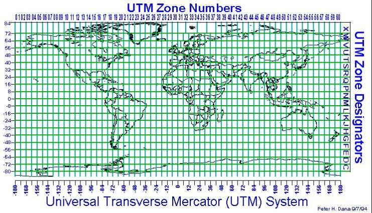
24 Universal Transverse Mercator (UTM) UTM projects a 2 axis grid onto the map UTM uses meters for positions
25 UTM Positions Your position is expressed using the UTM Grid For example, Eastside Fire and Rescue Headquarters (where course B is usually held) is located at 10 T E N The 10 represents the Zone number. Zones represent sections of longitude 6 apart The T represents the Row letter. Rows increase from South to North, beginning at the South Pole
26 UTM Positions (cont) The Easting is the position in the East-West direction The first four numbers (0571) represent the closest Easting line to the location. You can find this number along the bottom of the UTM Grid The last three numbers (974) represent the meters east from the 0571 line

27 UTM Positions (cont) The Northing is the position along the North-South direction The first four numbers (5264) represent the closest Northing line to the location. You can find this number along the side of the UTM Grid The last three numbers (772) represent the meters North of the 5264 line
28 UTM Advantages Easy to plot Easy to calculate distances between two locations Disadvantages Not common outside of government entities UTM grid discrepancy exists. This isn t too relevant for King County, but you ll learn more about this in class Metric distances aren t as popular in the States Not the default for most cell phones and GPS devices/applications
29 Scaling and Plotting In the following slides you will learn how to Determine the scale of your map Locate True North Plot Lat/Long coordinates Plot UTM Coordinates
30 Determining Scale One method to determine your scale is to just find it on your map For the map to the right, the scale is 1 in = 231 feet Be careful when using printed scales; they are usually associated with a certain page size. If the page has been shrunk/enlarged, the printed scale no longer works
31 Determining Scale (cont) Another method to find your scale is to take your ruler and measure a known value The scale gives you a known value. The bottom black line of the scale represents 0.1 miles. If you measure the length of that black line with your ruler, you would get XX inches = 0.1 miles Divide both sides by XX and you will get 1 inch = YY miles This works the same with feet, meters, and kilometers For this example, the scale is 1.55 inches = 0.1 miles, or 1:0.065
32 Determining Scale (cont) Alternatively, you can take your ruler and measure the distance between two UTM lines By looking at the UTM lines given, you should recognize that and are 100 meters apart. If you measure the length between two grid lines, you would get XX inches = 100 meters Divide both sides by XX and you will get 1 inch = YY meters For this example, the scale is 0.95 inches = 100 meters, or 1:105.26
33 Notes about scaling Most maps show UTM lines to be 1 km (1000 meters) or 2 km (2000 meters) apart. Be sure to check your printed scale or the values of the UTM lines Be careful with using distances marked on maps between points of interest or trail intersections; these are approximations
34 Locating True North Two methods to find True North Extend the North line in the Map Legend Connect Longitude lines Note: the north lines for the UTM grid DO NOT necessarily represent True North Note: The right and left edges of the map DO NOT necessarily represent True North either
35 Determining Bearings Lets try to find the bearing from Chair Peak to The Tooth Remember to connect your longitude lines, especially the ones adjacent to the point where you re starting to measure from Always connect the two points you re trying to find a bearing
36 Determining Bearings Before you place your protractor, you ll want to draw a north/south and east/west line over your starting point. This will help you align your protractor We ll go over methods in class on how to be more accurate; for now, pick any method you d like

37 Determining Bearings Reading the protractor gives you a bearing of 159 from Chair Peak to The Tooth The back bearing is 339 If you answer incorrectly, meaning you measured from The Tooth to Chair Peak, you would get a bearing of 339 and a back bearing of 159 Always be aware of where your starting and ending points are
38 Plotting Latitude and Longitude Steps 1. Connect all Latitude (Lat) and Longitude (Long) lines 2. Determine scales for Lat/Long. NOTE! The scale for Lat is different from the scale for long, which is different from your scale for distance. Lat/Long are generally measured in degrees, minutes or seconds 3. Determine your Northing 4. Determine your Easting
39 Connect Lat Long Lines This will make scaling and plotting a lot easier
40 Determine Latitude Scale Using the provided ruler, we can see that the latitude lines are 30 seconds (or 30 ) apart at a distance of 3.25 inches We can determine that 1 inch = 9.23, or 1/10 th of an inch = 0.923
41 Determine Longitude Scale From the map and ruler to the right, we know that 30 longitude is equal to 2.2 inches Therefore, 1 inch = 13.6, or 1/10 th of an inch = 1.36
42 Measure Northing For the northing, we measure 2.8 inches 2.8 inches* 9.23 = seconds We add this to the bottom latitude ( ) to get a Northing of
43 Measure Easting For the Easting, note that we are measuring from the longitude line on the right Longitude get smaller (more negative) going from East to West (right to left) For the Easting, we measure 0.65 inches from the right longitude line 0.65 * 13.6 = 8.84 Since we are traveling west from the longitude line, we would add this to the value of the longitude line Your position would be
44 Notes about Lat/Long Always provide your coordinates with all digits and values Using the previous Northing and Easting, you would report your position as WGS Northing, Easting In Lat/Long, the Northing is reported before the Easting
45 Plotting UTM Steps 1. Determine your Scale 2. Determine your Easting 3. Determine your Northing
46 Determining Scale Determine Scale For this example, the distance is 2.5 inches Therefore, your scale is 2.5 = 1000m You can simplify this by dividing both sides by the value you just measured 1 = 400 m Since we re using tenths rulers, divide each side by 10 to get the distance between each division 1 10 " = 40 m
47 Plotting a Point Using UTM Determine Easting The red star denotes the location you want to plot Place your ruler along the bottom line (4282) to measure the Easting
48 Plotting a Point Using UTM Determine Easting We can see that the point is approximately 1.85 inches, or 18.5 tenths from the left grid line Convert this to meters by multiplying your measured value by your scale 18.5 tenths 40 meters = 740 meters Add this value to the left gridlines value to get your Easting: m
49 Determine Northing Plotting a Point Using UTM Repeat this to get the Northing Convert this to meters by multiplying your measured value by your scale 4 tenths 40 meters = 160 meters Add this value to the bottom gridline value to get your Northing: m Note: Map publishers often abbreviate their UTM grids. You may see , 559, 5 58 for grid line labels.
50 Notes about UTM Always provide your coordinates with all digits and values Using the previous Easting and Northing, you would report your position as WGS 84 10T E N In UTM, the Easting is reported before the Northing
51 Contour Lines Contour lines are lines on a map that join positions of equal elevation (or height) For example, every point along the line 3800 is at an elevation of 3800
52 Contour Index Contour index(s) are bolded contour lines with the elevation defined These are spaced apart so the map is not cluttered with elevation marks on every contour line


53 Contour Interval Contour intervals is the distance between two adjacent contour lines Intervals are usually indicated near the scale of the map Intervals can be determined by looking at two contour indexes and dividing by the number of intervals between them 200 feet / 5 sections = 40 feet per interval
54 Reading Contour Intervals Areas where contour lines are close together indicate terrain that is steep Areas where contour lines are farther apart indicate less steep or flatter terrain
55 Approximating Steepness You can estimate the angle of a slope by comparing the elevation gain to the distance you need to travel to make that gain For example, if you were to travel directly between the two red dots and not follow the trail, you would gain approximately 200 feet of elevation over 328 feet The contour indexes are 200 feet apart, the distance between the UTM lines is 100 meters, or 328 feet 200 feet gain = feet traveled There s a little bit of trigonometry involved with this calculation, don t worry about it, you won t need it for basic training

56 Lets compare that to flatter terrain If you follow the trail between the red dots, you gain 80 feet in approximately 328 feet This slope is approximately 14

57 Finally, lets look at steeper terrain Here we go from elevation 4080 to 4980 (900 feet) in approximately 463 feet Distance was calculated using trigonometry again, don t worry, you won t be using this method for basic training The angle of this terrain is approximately 63
58 Terrain Types Some types of terrain you can see from a map
59 Valley Valleys are low areas between hills or ridges. They are longer than they are wide Great locations for water to travel Remember, water goes from areas of high elevation to low elevation
60 Ridge Ridges are chains of mountains or hills that form a continuous, elevated crest for some distance
61 Peak or Summit A peak or summit is a point that is higher in elevation that all points immediately adjacent to it.
62 Gully Gullies, or draws, are small valleys formed by running water These can be a few feet deep or hundreds of feet deep


63 Saddle Saddles, also known as passes, notches, or cols, are the lowest point between two area of high elevation

64 Plateau Plateaus usually consist of relatively flat terrain raised above the surrounding areas with one or more sides of steep slopes

65 Cirque A cirques, or bowls, are generally areas where a low area is surrounded on three sides by higher areas These can be found at the end of valleys
66 Homework Notes The homework can take a while to complete; anywhere from 1 to 10 hours. I highly suggest not waiting until Friday night to do your homework You can find a legend for the Green Trails map here: The map is a subsection of the Green Trails 207S map. You DO NOT have to purchase this map. If you already have one, great, feel free to use it; if not, you can still complete the homework assignment For help, feel free to me at courseb@kcesar.org. I ll generally try to respond within 24 hours. That being said, I will not be available Friday and Saturday before Course B. See the first bullet =)
67 Additional Resources The following are additional resources to navigate. None of them are quite like ESAR training, but they can make good practice for both mapping or field navigation KCSARA Navigation password is KingCountySAR (case sensitive). The KCSARA navigation training is different because they use different tools for determining location. Feel free to watch the videos, however, do not purchase the tools. They will not help you in Basic Training Mountaineers Navigation Orienteering/Geocaching
Butte County Fire Department
 Butte County Fire Department Basic Land Navigation Verification Sheet I verify that Print Supervisor s name has completed the Print Employee s name Basic Land Navigation self study guide on. Date Attached
Using Map and Compass Together
 Using Map and Compass Together In situations where you foresee a potential evacuation on foot, where there are no roads, and no indication as to the direction of travel (i.e., road signs), it is recommended
APPENDIX A GLOSSARY. Appendix A.1
 APPENDIX A GLOSSARY Appendix A.1 Appendix A.2 Back Bearing A back bearing is measured from the object to your position. It is the exact opposite of a direct bearing. Base Line An imaginary line on the
Topographic Maps and Landforms Geology Lab
 Topographic Maps and Landforms Geology Lab Ray Rector: Instructor Today s Lab Activities 1) Discussion of Last Week s Lab 2) Lecture on Topo Maps and Elevation Contours 3) Construct Topographic Maps and
Topographic Map Series:
 DEFINITION OF A MAP A MAP IS A GEOGRAPHIC PREPRESENTATION OF A PORTION OF THE EARTH S SURFACE DRAWN TO SCALE, AS SEEN FROM ABOVE. IT S USES COLORS, SYMBOLS AND LABELS TO REPRESENT FEATURES FOUND ON THE
Navigating with Map & Compass. Nevada County Sheriff s Search & Rescue
 Navigating with Map & Compass Nevada County Sheriff s Search & Rescue Objectives Very Practical Teach you how to go from point A to point B Go from the wilderness (real world) to a map and visa versa Agenda
Butte County Fire Department
 Butte County Fire Department Basic Land Navigation Verification Sheet I verify that Print Supervisor's name Print Employee's name has completed the Basic Land Navigation self study guide on Date Attached
AS 410 Land Navigation. Chpt 4-1
 AS 410 Land Navigation Chpt 4-1 Overview Types of Maps Map Legends / Scales Latitude and Longitude Orienteering Why? Why important to learn how to read a compass and map? No cell phone coverage Mountain
Chapter 3 Models of the Earth. 3.1 Finding Locations on the Earth. 3.1 Objectives
 Chapter 3 Models of the Earth 3.1 Finding Locations on the Earth 3.1 Objectives Explain latitude and longitude. How can latitude and longitude be used to find locations on Earth? How can a magnetic compass
UNIT 1C. USING TOPOGRAPHIC MAPS WHERE IN THE WORLD... ARE YOU?
 UNIT 1C. USING TOPOGRAPHIC MAPS WHERE IN THE WORLD... ARE YOU? TIME 60-90 minutes LEVEL All BENCHMARKS Next Generation Science Standards MS-LS1.D Science & Engineering Practices Developing and Using Models
USING THE MILITARY LENSATIC COMPASS
 USING THE MILITARY LENSATIC COMPASS WARNING This presentation is intended as a quick summary, and not a comprehensive resource. If you want to learn Land Navigation in detail, either buy a book; or get
B. Topographic maps are also called. contour maps
 Topographic Maps Introduction A. Topographic maps are essential tools in geologic and engineering studies because they show the configuration of Earth's surface in remarkable detail and permit one to measure
USING THE MILITARY LENSATIC COMPASS
 USING THE MILITARY LENSATIC COMPASS WARNING This presentation is intended as a quick summary, and not a comprehensive resource. If you want to learn Land Navigation in detail, either buy a book; or get
Basic Map Skills for the Outdoors
 Geography 80-20 80% of what there is to know, for 20% of the sweat Basic Map Skills for the Outdoors Map Scale Map source: US Geological Survey Four ways to indicate map scale: Representative fraction
Compass Basics. Quick Map Basics Review For Compass Use
 Compass Basics Quick Map Basics Review For Compass Use A topographic map tells you where things are and how to get to them, whether you're hiking, biking, hunting, fishing, or just interested in the world
Laboratory Exercise #2 Introduction to Quadrangle Maps
 page - 1 Laboratory Exercise #2 Introduction to Quadrangle Maps A. Introduction to Quadrangle Maps The United States Geological Survey has developed a nationwide series of quadrangle maps that cover small
56H. This system allows definition of points on the Earth s surface to within 100 meters. Page 20. Navigation Systems Basics of Maps
 Grid References Many maps are provided with the standard grid overlaying them. This provides a simple and accurate method for finding features on the map. It is a network of intersecting parallel lines
Laboratory Exercise #2 Introduction to Quadrangle Maps
 page - Laboratory Exercise #2 Introduction to Quadrangle Maps A. Introduction to Quadrangle Maps The United States Geological Survey has developed a nationwide series of quadrangle maps that cover small
Mapping Earth. How are Earth s surface features measured and modeled?
 Name Mapping Earth How are Earth s surface features measured and modeled? Before You Read Before you read the chapter, think about what you know about maps Record your thoughts in the first column Pair
Spatial locations. Spatial locations. Spatial locations. Spatial locations
 Where am I? sounds simple, but definitely not huge amount of picky detail Cartographers make a career from the details focus on the minimum you need to know c Philip M. Dixon (Iowa State Univ.) Spatial
Basic Land Navigation
 A Publication of the National Wildfire Coordinating Group National Interagency Incident Management System Basic Land Navigation PMS 475 June 2007 NFES 2865 JUNE 2007 NFES 2865 Sponsored for NWCG publication
Chapter 3 Geographic Location Systems
 Chapter 3 Geographic Location Systems In this chapter you will learn about: Latitude and longitude Universal Transverse Mercator (UTM) U.S. Public Land Survey Other geographic location systems Geographic
California Cadet Corps Curriculum on Maps and Navigation. Map Reading LEADERS KNOW THE WAY
 California Cadet Corps Curriculum on Maps and Navigation Map Reading LEADERS KNOW THE WAY 5/22/2017 Map Reading Agenda A1. Introduction to Maps A2. Topographical Map Basics A3. Elevation and Terrain Features
Chapter 1 Overview of Maps
 Chapter 1 Overview of Maps In this chapter you will learn about: Key points when working with maps General types of maps Incident specific maps Map legend and symbols Map sources A map is a navigational
Basic Land Navigation. Clark County Sheriff Core Comp Rev. # Land Navigation
 Basic Land Navigation Clark County Sheriff Core Comp Rev. # 2018 1 Land Navigation Requirement Through written evaluation the applicant will demonstrate knowledge of land navigation involved in Search
Trail Life USA High Adventure Training Land Navigation Module. Dennis Conte
 Trail Life USA High Adventure Training Land Navigation Module Dennis Conte Navigating With GPS and a MAP Let s Talk about your GPS Hand Held Tool. Is a GPS Hand Held the magic bullet? Can it solve all
Charts and Chart Work with Poole Sailing
 with Poole Sailing Nautical charts are a mine of information but they need to be up to date. Corrections to charts are published by the Hydrographic Office monthly as Notices to Mariners both in print
Lab Topographic Maps. Name: Partner: Purpose. Background Information
 Lab Topographic Maps Name: Partner: Purpose The purpose of this lab is to familiarize you with graphic representations of the Earth s surface primarily maps. Simple line maps show the spatial relationship
The Tacoma Mountaineers Wilderness Navigation
 The Tacoma Mountaineers Wilderness Navigation Navigation Fundamentals Navigation in mountainous terrain and wilderness areas requires a set of skills, of which using a map and compass is only one part.
Akuni Adventures GPS Navigation Course. Welcome
 Akuni Adventures GPS Navigation Course Welcome 1 GPS Navigation Course Instructor: Joe Bourgeois joe@akuni.com 2 Waiver Please take a moment to read and sign your waiver. Thank You 3 Maps: Agenda Margin
What is a map? A Map is a two or three-dimensional model or representation of the Earth s surface. 2-Dimensional map
 What is a map? A Map is a two or three-dimensional model or representation of the Earth s surface. 2-Dimensional map What is a Map Projection? Planar Projection Projection A Projection is a mathematical
BUSH NAV BUSH NAV DAY Navigation for Bush Navigation Day. November. WhitehorseD AY. Section 1 Registration, Maps & Checkpoints
 BUSH DAY Navigation for Bush Navigation Day Robert Kirwan, Nunawading SES W NW N NE E If you have little or no bush navigation experience then you will have been teamed up with members that have that experience
Geology 101 Lab Worksheet: Topographic Maps
 Geology 101 Lab Worksheet: Topographic Maps Name: Refer to the Topographic Maps Lab for the information you need to complete this worksheet (http://commons.wvc.edu/rdawes/g101ocl/labs/topomapslab.html).
Name Class Date. For each pair of terms, explain how the meanings of the terms differ.
 Skills Worksheet Chapter Review USING KEY TERMS For each pair of terms, explain how the meanings of the terms differ. 1. true north and magnetic north 2. latitude and longitude 3. equator and prime meridian
Test Bank Chapter 2: Representations of Earth
 Multiple Choice Test Bank Chapter 2: Representations of Earth 1. A rhumb line on a Mercator projection is a line of. a. true size b. true shape c. true compass bearing d. true location 2. Maximum longitude
Coach Answers Part 2 Zombie 17 COACH ANSWERS (Questions and answers with explanations) Part 2
 Part 2") Zombie 17 COACH ANSWERS (Questions and answers with explanations) Part 2 44. The Brain Building looks fairly new. Based on the map, what is the most recent year in which it could have been constructed?
Zombie 17 COACH ANSWERS (Questions and answers with explanations) Part 2 44. The Brain Building looks fairly new. Based on the map, what is the most recent year in which it could have been constructed?
Map Reading & Compass Use
 Spring 2013 Kestrel Land Trust Page 2 / 10 Contents Map Basics... 3 Map Types... 3 Terrain Association... 4 Estimating Distance: Pacing... 4 Contour Lines... 5 Navigating with a Compass... 6 Compass Types...
Latitude and Longitude
 U n i t 3 M a p p i n g P a g e 1 Latitude and Longitude Note: These coordinates are always expressed LATITUDE/LONGITUDE!!! Coordinate System: Using and to find your position on Earth. LATITUDE LATITUDE
Topographic Maps Self-Instruction Lab (2016 edition) Geology 100 David Harbor s Section. 12 inches x 1 mile
 Geology 100 David Harbor s Section. 12 inches x 1 mile") Topographic Maps Name Self-Instruction Lab (2016 edition) Geology 100 David Harbor s Section Topographic maps are an important aid for a geologist, but maps are also useful for hikers, bicyclists, and
Topographic Maps Name Self-Instruction Lab (2016 edition) Geology 100 David Harbor s Section Topographic maps are an important aid for a geologist, but maps are also useful for hikers, bicyclists, and
Practice Packet Topic 2: Measuring Earth
 Practice Packet Topic 2: Measuring Earth Vocabulary: Lesson 1: Lesson 2: Name: Lesson 3: Mini Lesson: Latitude Longitude Pre-Test 1. To locate exact places on the earth, one must look at a. The intersecting
From Science Olympiad Student Center
 1 of 10 3/5/13 8:18 AM Forums Wiki Test Exchange Image Gallery Score Tracker Road Scholar From Science Olympiad Student Center In Road Scholar, Forum Threads Tests There are no images available for this
Orienteering Maps & Map Reading Latitude and Longitude Scale
 Orienteering Maps & Map Reading A map is a two-dimensional representation of the three-dimensional world you'll be hiking in. All maps will have some basic features in common and map reading is all about
Activities: Map and Compass
 Activities: Map and Compass Determining General Directions Modified with permission from Outdoor Living Skills Series: Map and Compass, Missouri Department of Conservation Overview: Students use the sun
REVISION: MAPWORK 18 SEPTEMBER 2014
 REVISION: MAPWORK 18 SEPTEMBER 2014 Lesson Description In this lesson we revise: Various mapwork calculations Summary Relative Position Bearing is the angular (angle) distance between two points True Bearing
 Chapter 2 Mapping Our World Picture: Mount Capulin, Raton, NM Cinder Cone Volcano ://3.bp.blogspot.com/_sKz1KwXRzcg/SzFzM52gIoI/AAAAAAAAABk/hguBAT80pk0/s320/capulin.jpg http://www.peteandmelissa.com/images/oklahoma/p1020190.jpg
Chapter 02 Maps. Multiple Choice Questions
 Chapter 02 Maps Multiple Choice Questions 1. Every projection has some degree of distortion because A. a curved surface cannot be represented on a flat surface without distortion. B. parallels and meridians
What Do You See? FOR 274: Forest Measurements and Inventory. Area Determination: Frequency and Cover
 What Do You See? Message of the Day: Many options exist to determine the size, area, or extent of a feature on a landscape FOR 274: Forest Measurements and Inventory Lecture 7: Measures of Land Area Frequency
LAND NAVIGATION 2-1. DEFINITION
 LAND NAVIGATION MAPS Cartography is the art and science of expressing the known physical features of the earth graphically by maps and charts. No one knows who drew, molded, laced together, or scratched
YEAR 7 REVISION BOOKLET
 YEAR 7 REVISION BOOKLET Assessment checklist 1. To be able to define Geography. 2. Give examples of what we study in geography 3. Group what we study into the three major areas of geography 4. To be able
CHAPTER EXIT CHAPTER. Models of Earth. 3.1 Modeling the Planet. 3.2 Mapmaking and Technology. 3.3 Topographic Maps CHAPTER OUTLINE
 EXIT CHAPTER.1 Modeling the Planet.2 Mapmaking and Technology. Topographic Maps CHAPTER OUTLINE CHAPTER.1 Modeling the Planet A flat of Earth is a convenient tool, but it can distort the shape, distance,
Introduction to Contour Maps
 Your web browser (Safari 7) is out of date. For more security, comfort and Activityengage the best experience on this site: Update your browser Ignore Introduction to Contour Maps What information does
Class Notes: Mapping the Earth
 Name: Date: Period: Mapping the Earth The Physical Setting: Earth Science Class Notes: Mapping the Earth I. Latitude and Longitude Map -! Latitude -! Also called These lines intersect Equator -! The North
Unit 1: Mapping and Astronomy
 Unit 1: Mapping and Astronomy 1 Do Now In your notebook, write your thoughts on the following: -What do you know about the beginning location and trajectory of the most recent hurricanes (Harvey or Irma)?
Notes and Summary pages:
 Topographic Mapping 8.9C Interpret topographical maps and satellite views to identify land and erosional features and predict how these shapes may be reshaped by weathering ATL Skills: Communication taking
Advanced Vectors. Table of Contents
 Advanced Vectors Table of Contents I. Location and Distance on Earth 2 Introduction Determining Latitude Latitude and the North Star Determining Longitude Longitude and Time Using Earth's Grid System Google
Different types of maps and how to read them.
 Different types of maps and how to read them. A map is a picture or representation of the Earth's surface, showing how things are related to each other by distance, direction, and size. Maps have been
Adventure Racing Navigation Supplies. Table Top Adventure Race & Navigation Challenge. Preview
 Adventure Racing Navigation Supplies Table Top Adventure Race & Navigation Challenge 12 Navigation Challenges for Map and Compass Navigation Volume 1. June 2009 Presented by AR Navigation Supplies, Inc.
Date: UNI. world. *Dedicated to
 Name: Date: UNI IT THREE 2D and 3D model s of the natural world *Dedicated to Name: Date: ABSTRACT T AND RATIONALE A topographic map is a type of map that depicts the detail and quantitative representation
GCSAR Navigation -- Maps
 GCSAR Navigation -- Maps From the GCSAR Certification Standards Identify and explain all the border information on a topographic map. Identify and explain the following aspects of maps: index and intermediate
Military Map Reading 201
 Military Map Reading 201 This information paper is designed to resolve the confusion between the Universal Transverse Mercator (UTM) and the Military Grid Reference System (MGRS) coordinates. The two systems
Topographic Maps and Profiles
 Name: Date: Period: Earth Science Foundations The Physical Setting: Earth Science CLASS NOTES! Topographic Maps [contour maps] -! Topographic maps show three-dimensional shapes in two dimensions Elevation
Road Scholar. Coaches Clinic
 Coaches Clinic Test Format Review of Individual Test Elements Items to Bring Tips Links General Test Format: Storyline Test Navigation Elements Identification of Landmarks, features, etc. Aerial/Satellite
Map Skills Lesson 1. Materials: maps, pencils, Lesson 1 Worksheet, strips of paper, grid paper
 Map Skills Lesson 1 Use cardinal directions, map grids, scales, and titles to locate places on a map. Interpret a map using information from its title, compass rose, scale, and legend. Vocabulary: map,
Basic Land Navigation
 A Publication of the National Wildfire Coordinating Group National Interagency Incident Management System Basic Land Navigation PMS 475 June 2007 NFES 2865 Basic Land Navigation JUNE 2007 NFES 2865 Sponsored
STAAR Science Tutorial 40 TEK 8.9C: Topographic Maps & Erosional Landforms
 Name: Teacher: Pd. Date: STAAR Science Tutorial 40 TEK 8.9C: Topographic Maps & Erosional Landforms TEK 8.9C: Interpret topographic maps and satellite views to identify land and erosional features and
Fri. Jan. 26, Demonstration of QGIS with GPS tracks. Types of data, simple vector (shapefile) formats
 formats") Fri. Jan. 26, 2018 Demonstration of QGIS with GPS tracks Types of data, simple vector (shapefile) formats Map projections, Coordinate Reference Systems Demonstration of QGIS with geologic map 1 Raster
Fri. Jan. 26, 2018 Demonstration of QGIS with GPS tracks Types of data, simple vector (shapefile) formats Map projections, Coordinate Reference Systems Demonstration of QGIS with geologic map 1 Raster
Navigating for Scouts A Self-teaching Guide to Navigation with Map and Compass
 Don Burgess, November 2003 Materials topographic maps Navigating for Scouts A Self-teaching Guide to Navigation with Map and Compass metric ruler orienteering compass 30 M/5 Hamilton-Burlington 41 I/13
Earth Science Regents Reading Topographic Maps
 Earth Science Regents Reading Topographic Maps Name Period Quick Tutorial on Degrees, Minutes, and Seconds of Latitude and Longitude A degree of latitude on the surface of the earth is about 70 miles long.
APPENDIX F PRE-COURSE WORK
 APPENDIX F PRE-COURSE WORK F-1 Pre-Course Work F-2 Pre-Course Work Intermediate Wildland Fire Behavior, S-290 Pre-Course Work The pre-course work is designed to ensure that students come to class with
11. ALPINE GLACIAL LANDFORMS
 Geomorphology 11. Alpine Glacial Landforms 11. ALPINE GLACIAL LANDFORMS 40 Points One objective of this exercise is for you be able to identify alpine glacial landforms and measure their characteristics.
Introduction to Cartography Part I
 Introduction to Cartography Part I Introduction to Cartography Maps vs. Globes General Types of Maps Standard Map Features Maps versus Globes Map: a representation of the world, or part of it, in two dimensions
Earth Science Unit 1 Test
 Earth Science Unit 1 Test Multiple Choice Identify the choice that best completes the statement or answers the question. 1. The study of meteorology involves the study of a. climate. c. animals. b. outer
PROJECTIONS AND COORDINATES EXPLORED THROUGH GOOGLE EARTH EXERCISE (SOLUTION SHEET)
") PROJECTIONS AND COORDINATES EXPLORED THROUGH GOOGLE EARTH EXERCISE (SOLUTION SHEET) Name: Date: Period: Note: Correct answers on some problems are indicated with a yellow highlight. PROJECTIONS 1. Here
PROJECTIONS AND COORDINATES EXPLORED THROUGH GOOGLE EARTH EXERCISE (SOLUTION SHEET) Name: Date: Period: Note: Correct answers on some problems are indicated with a yellow highlight. PROJECTIONS 1. Here
Map and Compass Skills
 Map and Compass Skills Grade levels: 5-12 In a Nutshell Given a map and compass, students will be able to find a location on the map, chart a course to that location with the compass, and find that location
Homework - Topographic Maps and What They Mean - Standard Earth Science
 Name: Mr. Schwartz Earth Science Period: Date: /10 Homework - Topographic Maps and What They Mean - Standard Earth Science Read pages 46-47 and 53-56 in your text. Then, answer the questions. Don t forget
NR402 GIS Applications in Natural Resources Lesson 4 Map Projections
 NR402 GIS Applications in Natural Resources Lesson 4 Map Projections From http://www.or.blm.gov/gis/ 1 Geographic coordinates Coordinates are expressed as Latitude and Longitude in Degrees, Minutes, Seconds
2 Mapping Earth Reading Essentials. 2. Contrast What is the difference between a map view and a profile view?
 Mapping Earth Maps What do you think? Read the three statements below and decide whether you agree or disagree with them. Place an A in the Before column if you agree with the statement or a D if you disagree.
AP Human Geography Chapter 1: Thinking Geographically Key Issue 1: How do Geographers describe where things are?
 AP Human Geography Chapter 1: Thinking Geographically Key Issue 1: How do Geographers describe where things are? Studying Human Geography Physical Geography Physical geography deals with Earth s natural
Land Navigation Table of Contents
 Land Navigation Table of Contents Preparatory Notes to Instructor... 1 Session Notes... 5 Learning Activity: Grid Reference Four Figure... 7 Learning Activity: Grid Reference Six Figure... 8 Learning Activity:
MAPPING THE EARTH HOW DO YOU FIND A LOCATION ON THE EARTH?
 MAPPING THE EARTH HOW DO YOU FIND A LOCATION ON THE EARTH? UNIT TOPICS TOPIC 1: LATITUDE & LONGITUDE TOPIC 2: FIELD MAPS TOPIC 3: TOPOGRAPHIC MAPS TOPIC 4: NYS LANDSCAPES TOPIC 1: LATITUDE & LONGITUDE
Projections and Coordinate Systems
 Projections and Coordinate Systems Overview Projections Examples of different projections Coordinate systems Datums Projections Overview Projections and Coordinate Systems GIS must accurately represent
Understanding and Implementing the US National Grid
 Understanding and Implementing the US National Grid A training course designed to provide geospatial professionals the understanding and skills to support emergency responders and decision makers with
Georeferencing. Place names Postal addresses Postal codes Coordinate systems (lat/long, UTM, etc.)
") Georeferencing Georeferencing Used to describe the act of assigning locations to data or information Certain requirements include that they are: unique, have shared meaning, and are persistent through
Georeferencing Georeferencing Used to describe the act of assigning locations to data or information Certain requirements include that they are: unique, have shared meaning, and are persistent through
Understanding Positional Astronomy Part 2 Celestial Co-ordinates Difficulty: Intermediate
 Exercise: Understanding Positional Astronomy Part 2 Celestial Co-ordinates Difficulty: Intermediate Objectives In Part 1 you learned about Celestial Sphere and how the stars appear to move across the night
EOS 102: Dynamic Oceans Exercise 1: Navigating Planet Earth
 EOS 102: Dynamic Oceans Exercise 1: Navigating Planet Earth YOU MUST READ THROUGH THIS CAREFULLY! This exercise is designed to familiarize yourself with Google Earth and some of its basic functions while
Georeferencing, Map Projections, Cartographic Concepts. -Coordinate Systems -Datum
 Georeferencing, Map Projections, Cartographic Concepts -Map Projections -Coordinate Systems -Datum Map projection is "the process of systematically transforming positions on the Earth's spherical surface
NAVIGATION. 2. Marginal Information
 NAVIGATION 1. The Map Definition and Handling A map is a graphic representation, usually on a plane surface and at an established scale, of natural or artificial features on the surface of a part or a
Shape e o f f the e Earth
 1 Coordinate Systems & Projections Coordinate Systems Two map layers are not going to register spatially unless they are based on the same coordinate system. 2 Contents Shape of the earth Datum Projections
NAME DATE TOPOGRAPHIC MAPS. Activity 1: Topographic Map Investigation I: More Than a Road Map
 NAME DATE PARTNER(S) TOPOGRAPHIC MAPS Now you have seen how topographic maps can be generated to present the elevation of a terrain. Let s look at some topographic maps and learn how to interpret them.
Welcome to Lesson 4. It is important for a GIS analyst to have a thorough understanding of map projections and coordinate systems.
 Welcome to Lesson 4. It is important for a GIS analyst to have a thorough understanding of map projections and coordinate systems. A GIS without coordinates would simply be a database like Microsoft Excel
Navigation and Communication AS January Sara Mollie Cohen Head Engineer, Department of Arctic Geology
 Navigation and Communication AS101 07-11 January 2019 Sara Mollie Cohen Head Engineer, Department of Arctic Geology Course Objectives Navigation Maps, Coordinate Sysems GPS, TopoSvalbard, Weather Communication
Navigation. Longitude and Latitude Foundations of Navigation. MTPs:
 Navigation 3.01 Foundations of Navigation References: FTGU pages 177-178, 184-190 Transport Canada Study and Reference Guide Glider Pilot Canada Flight Training Manual Pilot Navigation http://en.wikipedia.org/wiki/transverse_mercator_projection#spherical_transverse_mercator
Lesson 5: Map Scale and Projections
 Organizing Data and Information Lesson 5: Map Scale and Projections Map Scales Projections Information can be organized as lists, numbers, tables, text, pictures, maps, or indexes. Clusters of information
Solar Schoolhouse Human Sundial Building a Sundial with the Online Calculator
 Solar Schoolhouse Solar Schoolhouse Human Sundial Building a Sundial with the Online Calculator Overview Analemmatic sundials are sundials which have a movable gnomon (the gnomon is the part that casts
The ABC's of Compass and Map STUDENT WORKBOOK
 The ABC's of Compass and Map STUDENT WORKBOOK 1 EXERCISE 1: Compass Part Identification Directions: Match the terms below with the correct parts on the compass diagram. NOTES: A. Azimuth Ring B. Compass
GPS Measurement Protocol
 GPS Measurement Protocol Purpose To determine the latitude, longitude, and elevation of your school and of all your GLOBE sites Overview The GPS receiver will be used to determine the latitude, longitude
Latitude and Longitude, Plus Map Scale
 Name Lab 4 More Date: Latitude and Longitude, Plus Map Scale In the first few labs of the semester, you found that you needed to look at a variety of maps to answer all the questions. One reason you needed
AP Physics C Mechanics Summer Assignment
 AP Physics C Mechanics Summer Assignment 2018 2019 School Year Welcome to AP Physics C, an exciting and intensive introductory college physics course for students majoring in the physical sciences or engineering.
Chapter 3 SECTION 1 OBJECTIVES
 Chapter 3 SECTION 1 OBJECTIVES Distinguish between latitude and longitude and locate coordinates on maps. Explain how latitude and longitude can be used to locate places on Earth s surface. Explain the
Scientists observe the environment around them using their five senses.
 Earth Science Notes Topics 1: Observation and Measurement Topic 2: The Changing Environment Review book pages 1-38 Scientists observe the environment around them using their five senses. When scientists