Geodetic Integrity The Essential for Data Managers and Users March 13, 2013, Houston
|
|
|
- Jonathan Collins
- 5 years ago
- Views:
Transcription


1 Experts in Geomatics, Surveying, Positioning, Geospatial Data, and Mapping Sciences Geodetic Integrity The Essential for Data Managers and Users March 13, 2013, Houston Michael Barnes APSG Foundation Chair APSG Chair
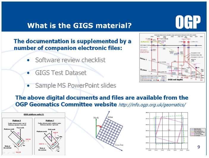
2 Data Tools Zone of the Geospatial Data Management Quagmire Knowledge Techniques Source: Cain & Barnes LP 2
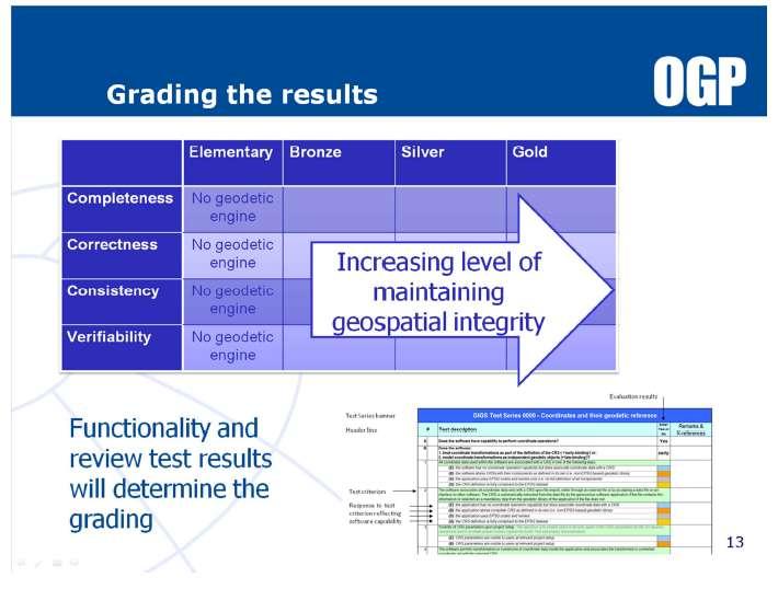
3 Contents Geodesy Class Fundamental Exploration Datasets (seismic, wells, boundaries) 3 geospatial data innovations you need to consider (satellite imagery, 3D printing, OGP area polygons) New Industry Standard: Geospatial Integrity of Geoscience Software (GIGS) Training Results Geodetic data handling 3
4 The 5 geodetic facts you need to know in Geospatial Data Management 1. Geodetic Datum 2. Map Projection 3. Vertical Reference 4. Reference Orientation 5. Unit of Measurement 4
5 Geodesy explained in 2 ½ minutes NASA created a cartoon called Looking Down a Well: A Brief History of Geodesy Geodesy is a field of study that deals with the measurement and representation of the Earth, and it all started when a clever human named Eratosthenes discovered that you could measure the circumference of the Earth by looking down a well. Over time, the field of geodesy has expanded and evolved dramatically, and NASA uses technology like radio telescopes, ground surveys, and satellites to contribute! Learn more about geodesy in this video! 5
 Source:")
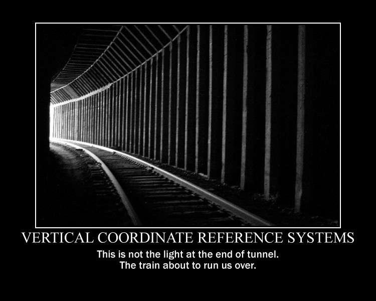
6 Geodetic Reference Surfaces h H N Normal to Ellipsoid Normal to Geoid N=h-H Ellipsoid Geoid Terrain b a Geoid Equipotential surface which approximates to MSL Ellipsoid Surface where Computations are made 1/f = a/(a-b) Source: APSG 6

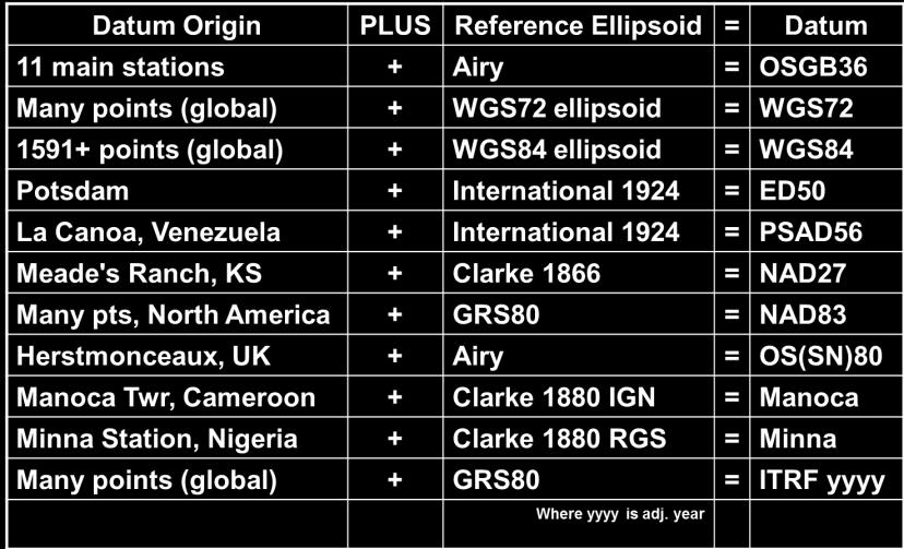
7 Examples of Geodetic Horizontal Datums 7

8 How many geodetic datums? Review 8

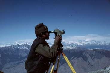
9 Before GPS we had 130 years of geodetic surveying e.g. National Geodetic Survey of Nepal

10 Geodetic Survey Network Diagram 10


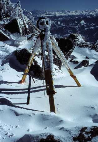
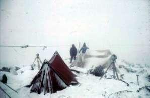
11 Creating geodetic datums was challenging work Source: Mick Paskin Nepal
12 One of 450 Geodetic Datums used Worldwide 12
13 Hierarchy of Geospatial Data and Mapping Ellipsoid λp Equator Yp Φp hp P Zp Xp Projected CRS is a derivative of the Datum (Geog CRS) Easting, Northing, Elevation (above MSL) stable Unstable w/o Datum Datum (ellipsoid & origin) is the Foundation X,Y,Z Cartesian and Lat, Long, Ht Source: APSG 13

14 What are the main map projections in use? Mercator Transverse Mercator Universal Transverse Mercator Lambert Conformal Conic Others less frequently: Stereographic, Oblique Stereographic, Oblique Mercator, et. al. 14
15 Height, elevation, vertical datum or what? Local Kelly-Bushing, ground level, sea level, and assorted other local references Geodetic Either directly or derived from Mean Sea Level at one or more points at some epoch examples: NGVD 29, NAVD 88, IGLD85, OSU91A, EGM96 Tidal Defined by direct observation of tidal variations over some period of time at a specific location (or locations) examples: MSL, LAT, MLLW, MLW, MHW, MHHW 15
16 Potential for confusion with Local Vertical Datum Source: UKOAA, now OGP 16
17 17
18 Reference orientations (5 kinds of north) True North = Direction of the meridian through a point Magnetic North = Differs from True North by declination and varies with time Grid North = Differs from True North by convergence Gyro North = a measurement of True North by instrument Plant North = strictly a local non-georeferenced orientation 18
19 Data handling of reference north From various well documents and databases Casing MWD: Magnetic (referenced to Magnetic North) Below Casing: Inertial (referenced to True or Gyro North) Rig orientation: (referenced to Grid N or True N?) When data are merged: Was the magnetic data adjusted to grid or true N? Has the rig orientation used the same North reference? Is all this documented for other departments / users? Do specifications lead to consistent results? Was there QC of the onsite methods and data? Is there a clear and informative report? What is the default north in your application? 19
20 Units of Measurement (13 kinds of feet and 2 kinds of meters in use) Reference Units: Biggest E&P Problem US Survey Foot vs. International Foot 1 ftus = ft (Intl), but this is still important for UTM, generating foot errors, depending on latitude Other Feet: Clarke s Foot, Sears 1922, 2 for Benoit (both 1895), Gold Coast Ft., 4 Indian Ft. (1865, 1937, 1962 & 1975) and 2 British Feet (1865 & 1935), 2 meters: International Meter and German Legal Meter Other linear units include Chains, Links, and Yards 20
21 If you remember nothing else.. Latitudes and Longitudes are not unique unless qualified with datum name Projection Coordinates are not unique unless qualified with Projection name, Zone and Datum Heights are not unique unless qualified with Surface Reference (Vertical Datum) Orientations are not unique unless qualified with Heading Reference Units are not unique unless qualified with Unit Reference 21
22 Data Acquisition & Sourcing Processing & Integration Integrity & Handling Data basing & Retrieval Tools Project Work Knowledge Techniques 22
23 Fundamental Exploration Data Sets Seismic Surveys Wells, surface and well bore locations Boundaries, lease and license areas 23

24 Source: OGP 24
25 Source: OGP 25


26 80% + of all GG&E data Easting and Northing, X and Y or Y and X? Units of Measure stated? e.g. US Survey Foot International Foot Meter, etc Mandatory Metadata 26

27 NAD83 Seismic Survey incorrectly mapped as NAD feet of error as a block shift 27

28 Commercial Well Location Data Source: APSG 28
 Source:")
29 Digital Land Grids (Cadastral) Source: APSG 29

30 Area Discrepancy due to Incorrect Grid 30

31 Example Unit with Discrepancies Measured 31

32 Various State & Vendor Database Well Locations 32

33 Source: Conner 33

34 Source: Conner 34


35 Well Surface Locations are frequently wrong Source: EnSoCo 35
36 Reasons for Mislocation of Wells Accuracy and reliability of original measurement systems and cartographic layers Miscalculations and poor QC Error in transformation of Coordinate Reference Systems Transcription errors, data entered incorrectly Transposing legacy data via new technologies Inadequate documentation Lack of industry standards for surveying and mapping 36

37 37
38 Corporate Geospatial Data Managed at global or business unit level Company Propriety data Lease boundaries and licensed areas Seismic Well data Topographic and bathymetry Site survey and environmental data Infrastructure (pipelines, platforms, cables..) Geodetic Parameters Third party industry data Seismic multiclient and speculative Well database Geologic data High resolution aerial and satellite imagery Gravity and magnetics Geodetic Parameters 38

39 Geodetic Integrity of Geospatial Data Past, Present and Future Source: OGP GIGS 39
40 Innovations in data use still requires sound geodetic and mapping principles 40

41 Time Lapse Plant refurbishment Iraq 7 months of overlay data 41
42 42

43 Wyoming Geo-Information Integration 2010 DEM 2006 photography 1964 Surficial Geology 1968 topo 2012 topo 2012 aerial 43
44 Wyoming 2D Data Geodetic Parameters Options NAD27 NAD83 WGS84 NAD27 / BLM 12N (ftus) NAD27 / BLM 13N (ftus) NAD27 / UTM zone 12N NAD27 / UTM zone 13N NAD27 / Wyoming West NAD83 / BLM 12N (ftus) NAD83 / BLM 13N (ftus) NAD83 / UTM zone 12N NAD83 / UTM zone 13N NAD83 / Wyoming West NAD83 / Wyoming West (ftus) NAD83(HARN) / UTM zone 12N NAD83(HARN) / UTM zone 13N NAD83(HARN) / Wyoming West NAD83(HARN) / Wyoming West (ftus) NAD83(NSRS2007) / UTM zone 12N NAD83(NSRS2007) / UTM zone 13N NAD83(NSRS2007) / Wyoming West NAD83(NSRS2007) / Wyoming West (ftus) SPCS83 Wyoming West zone (meters) SPCS83 Wyoming West zone (US Survey feet) 44
45 CRS Metadata inadequate? What is mislocation risk? NAD27 NAD83 WGS84 NAD27 / BLM 12N (ftus) NAD27 / BLM 13N (ftus) NAD27 / UTM zone 12N NAD27 / UTM zone 13N NAD27 / Wyoming West NAD83 / BLM 12N (ftus) NAD83 / BLM 13N (ftus) NAD83 / UTM zone 12N NAD83 / UTM zone 13N NAD83 / Wyoming West NAD83 / Wyoming West (ftus) NAD83(HARN) / UTM zone 12N NAD83(HARN) / UTM zone 13N NAD83(HARN) / Wyoming West NAD83(HARN) / Wyoming West (ftus) NAD83(NSRS2007) / UTM zone 12N NAD83(NSRS2007) / UTM zone 13N NAD83(NSRS2007) / Wyoming West NAD83(NSRS2007) / Wyoming West (ftus) SPCS83 Wyoming West zone (meters) SPCS83 Wyoming West zone (US Survey feet) 45

46 3D printing direct from GIS data 46

47 OGP ESPG Area Polygons reducing risk in handling of geodetic data 2,900+ polygons available online Source: OGP 47

48 Polygon Example: Nigeria Onshore and EEZ Rectangular Bounding Box 11 geodetic datums 13 Projected CRS* 25 transformations Geographic Area Polygon 3 geodetic datums 9 Projected CRS* 13 transformations * = datum + map projection 48
49 Data Acquisition & Sourcing Processing & Integration Integrity & Handling Data basing & Retrieval Tools GNSS (GPS) Positioning GIS Mapping Geoscience Software Engineering Software Project Work Knowledge Techniques 49

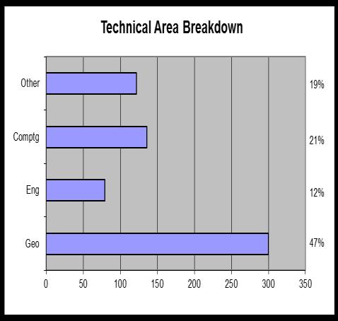
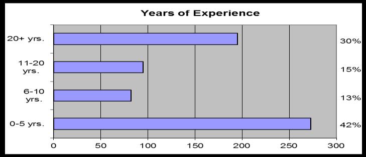
50 Source: Schostak 50
51 51


52 for GIGS industry standards documentation 52
53 53
54 54
55 Data Acquisition & Sourcing Processing & Integration Integrity & Handling Data basing & Retrieval Tools GNSS (GPS) Positioning GIS Mapping Geoscience Software Engineering Software Knowledge Basic Geography College, University Industry Training Learning & Development Project Work Techniques 55
56 56
57 ExxonMobil Class Features Geodesy and Cartography in the Upstream One day awareness, instructors lead training 5 modules covering: Overview Geodetic Datums, Coordinate Reference Systems and Transformations Map Projections Vertical Coordinate Reference Systems Wrap up and References

58 867 Class Participants

59 Class Geography
60 Demographics of Participants

61 Relevant and Useful?

62 Data Acquisition & Sourcing Processing & Integration Integrity & Handling Data basing & Retrieval Tools GNSS (GPS) Positioning GIS Mapping Geoscience Software Engineering Software Knowledge Basic Geography College, University Industry Training Learning & Development Zone of the Geospatial Quagmire Techniques Standards & Practices Procedures & Workflows Quality Control Processes Continuous Improvement Source: Cain & Barnes LP 62
63 Forensic Geodetics of Well Location (US GOM) Followed the data from G&G through Drilling Operations 486 documents with well location stated Location stated as X and Y Often stated as UTM 16N ftus (aka BLM) NAD 27 and NAD 83 both are relevant 40% had no datum stated Geoscience data handling in UTM 15 and 16 at various stages of process Positioning difference is. Cost of the well is 63

64 NAD27 / UTM 15N vs. NAD83 / UTM 15N Positioning difference is 656 feet Cost of Well US$ 85 million 64
65 Some geodetic challenges in the US Petroleum Industry Staying sane with 2 working datums (NAD27 and NAD83 are both relevant) Dependency on legal documents as delineation authorities Inconsistent landgrid base map Planned and measured wellbores 65
66 Last words. Coordinate Quality Coordinate Precision Coordinate Transformations 66

67 Coordinate Quality the ignored attribute Almost never Compared to what Zero industry standard Source plus transactions 67
68 Geodetic Quality of Positioning Data by Grammar Original Datum Known Source Vintage Known Unknown (Assumed) Proprietary Operated by Other (OBO) Licensed Government or Commercial > s 1980s 1970s < 1970 Location Quality Possibilities Excellent Good Fair Poor Field Documentation Complete Documentation Partial Documentation No Documentation Format Digital Media (Tape, CD, etc.) Transcribed (Keypunched, etc.) Digitized from map Offshore Positioning GPS or GPS/INS Short Range Radio Navigation Long Range Radio Navigation Transit / Doppler Unknown Onshore Positioning GPS or GPS/INS Surveying from Geodetic Control Surveying from Map or Cadaster Unknown 68
69 Geodetic Quality of Positioning Data by Positional Accuracy (TX RRC) 69

70 Geodetic Quality of Positioning Data by Statistical Measure 70

71 Coordinate Precision of Presentation 71
72 72

73 Transforming Coordinate Reference Systems Concatenated data operations are not trivial Source: OGP EPSG Registry 73
74 Geospatial Data Management Functions, Activities, & Relationships are not trivial Satellite Aerial Map Data Property Lease DB Review Acquisition & Processing Data Loading & Interpretation Ownership/PSC Requirements Data from Industry DB Interpretation System SW Review Middleware Drilling Facilities & Pipelines Reservoir Management Production Existing Well/Seismic Data Acquisition Field QC Review Velocity Picking/ Mapping Application Management Drilling Review Pre Lease Sale Eval n Lease Contract Boundary Geological Prospecting 2D, 3D Seismic Acquisition Seismic Processing Data Loading Interpretation Proposed Well Location Drilling Directional Drilling Pipelines and Facilities Installation Production 2D, 3D Seismic Data Purchase In-house Review P1/90 Bin Center Data Loading Sheets Review Exploitation & Volumetrics WS Admin Site Survey Production Planning Geophysical Planning Reservoir Analysis & Management 4D Seismic Acquisition & Processing Functional Activities Sub-Functional Activities Vendor Application & Data Management Spatial Review Development Planning Source: Jon Stigant GIS/Mapping Management Requirement Reformatting, Re-referencing and Re-presenting Spatial Data
75 Data Tools Zone of the Geospatial Data Management Quagmire Knowledge Techniques 75


76 Further information or clarification? Houston based, 440+ experts in geomatics, surveying, positioning, geospatial data and mapping sciences 76
Basic Geodetics What Every GIS User Should Know
 Experts in Geomatics, Surveying, Positioning, Geospatial Data, and Mapping Sciences Basic Geodetics What Every GIS User Should Know Michael Barnes Cain & Barnes LP michael.barnes@cain-barnes.com Steven
Geodetics: Implications for GIS Professionals May 10, 2018
 Experts in Geomatics, Surveying, Positioning, Geospatial Data, and Mapping Sciences Geodetics: Implications for GIS Professionals May 10, 2018 Michael Barnes APSG Education Foundation Chair 2010-2020 APSG
PPDM Data Management Symposium March 7, 2012 Houston
 Experts in Geomatics, Surveying, Positioning, Geospatial Data, and Mapping Sciences PPDM Data Management Symposium March 7, 2012 Houston Michael Barnes APSG Foundation Chair 2010-2015 APSG Chair 2008-2009
Connecting the Dots. A Model for Enterprise Wide Excellence in Spatial Data Management
 Connecting the Dots A Model for Enterprise Wide Excellence in Spatial Management IHS Users Group Presentation Finding and producing hydrocarbons Mapping Sciences Making and Communicating with Maps Sources
This week s topics. Week 6. FE 257. GIS and Forest Engineering Applications. Week 6
 FE 257. GIS and Forest Engineering Applications Week 6 Week 6 Last week Chapter 8 Combining and splitting landscape features and merging GIS databases Chapter 11 Overlay processes Questions? Next week
BUILDING AN ACCURATE GIS
 BUILDING AN ACCURATE GIS 2006 GIS in the Rockies Denver, Colorado September 13, 2006 William E. Linzey United States Department of Commerce National Oceanic and Atmospheric Administration National Geodetic
What is a Map Projection?
 What is a Map Projection? It is how we represent a three dimensional Earth on a flat piece of paper However The process of transferring information from the Earth to a map causes every projection to distort
You might know your position precisely but do you know where you are?
 You might know your position precisely but do you know where you are? Whosoever wishes to know about the world must learn about it in its particular details. The possession of knowledge does not kill the
Introduction to Geographic Information Science. Updates/News. Last Lecture. Geography 4103 / Map Projections and Coordinate Systems
 Geography 4103 / 5103 Introduction to Geographic Information Science Map Projections and Coordinate Systems Updates/News Thursday s lecture Reading discussion 1 find the readings online open questions,
Applied Cartography and Introduction to GIS GEOG 2017 EL. Lecture-1 Chapters 1 and 2
 Applied Cartography and Introduction to GIS GEOG 2017 EL Lecture-1 Chapters 1 and 2 What is GIS? A Geographic Information System (GIS) is a computer system for capturing, storing, querying, analyzing and
Georeferencing, Map Projections, Cartographic Concepts. -Coordinate Systems -Datum
 Georeferencing, Map Projections, Cartographic Concepts -Map Projections -Coordinate Systems -Datum Map projection is "the process of systematically transforming positions on the Earth's spherical surface
EnvSci360 Computer and Analytical Cartography
 EnvSci360 Computer and Analytical Cartography Lecture 3 Geodesy Map Projections, Datums, and Coordinate Systems 1 Geodesy The science of measuring and representing the shape and size of the earth, and
Lesson 5: Map Scale and Projections
 Organizing Data and Information Lesson 5: Map Scale and Projections Map Scales Projections Information can be organized as lists, numbers, tables, text, pictures, maps, or indexes. Clusters of information
12/26/2012. Geographic Information Systems * * * * GIS (... yrezaei
 ( - Geographic Information Systems ( ( 1 2 3 Information System Data base DB IS IS DB (Knowledge ( ( (System (Information System - (Georefrence Analysis Data + Knowledge ======== Information 4 5 ( < 10%
Overview key concepts and terms (based on the textbook Chang 2006 and the practical manual)
") Introduction Geo-information Science (GRS-10306) Overview key concepts and terms (based on the textbook 2006 and the practical manual) Introduction Chapter 1 Geographic information system (GIS) Geographically
Introduction Geo-information Science (GRS-10306) Overview key concepts and terms (based on the textbook 2006 and the practical manual) Introduction Chapter 1 Geographic information system (GIS) Geographically
Shape of the Earth. Data Output by the Receiver
 It is quite common for confusion to arise about the process used during a hydrographic survey when GPS-derived water surface elevation is incorporated into the data as an RTK Tide correction. This article
Geospatial Data Standards Considerations for the delivery of 2D and 3D spatial data February 2019
 Geospatial Data Standards Considerations for the delivery of 2D and 3D spatial data February 2019 Prepared by: GRCA Geomatics Version Date Summary of Changes Changes Made By: 1.00 March 16, 2018 Version
"Our Profession: Today and the Next Ten FiveYears" Jack Verouden Outgoing Chairman OGP Surveying & Positioning Committee
 "Our Profession: Today and the Next Ten FiveYears" Jack Verouden Outgoing Chairman OGP Surveying & Positioning Committee and Shell Chief Surveyor Greenwich Meridian 112 m No error in Google Earth: Different
DATA SOURCES AND INPUT IN GIS. By Prof. A. Balasubramanian Centre for Advanced Studies in Earth Science, University of Mysore, Mysore
 DATA SOURCES AND INPUT IN GIS By Prof. A. Balasubramanian Centre for Advanced Studies in Earth Science, University of Mysore, Mysore 1 1. GIS stands for 'Geographic Information System'. It is a computer-based
How does an ellipsoid differ from a sphere in approximating the shape and size of the Earth?
 Chapter 02 Test Bank Worksheet Questions 1. What is a map projection? Topic: Map Projection 2. How does an ellipsoid differ from a sphere in approximating the shape and size of the Earth? Topic: Ellipsoid
Map projections. Rüdiger Gens
 Rüdiger Gens Coordinate systems Geographic coordinates f a: semi-major axis b: semi-minor axis Geographic latitude b Geodetic latitude a f: flattening = (a-b)/a Expresses as a fraction 1/f = about 300
GIS in Water Resources. Fall Homework #1
 GIS in Water Resources Fall 2015 Homework #1 Goal The goal of this homework is to reinforce the lecture material on Geodesy, Map Projections and Coordinate Systems by having you identify attributes and
VT State Plane. Daniel J. Martin National Geodetic Survey VT Geodetic Advisor. VSLS Conference Rutland VT April 11, 2008
 VT State Plane Daniel J. Martin National Geodetic Survey VT Geodetic Advisor VSLS Conference Rutland VT April 11, 2008 Today s Outline Define the problem Review of VT State Plane System Relationship
Solving the "Grid to Ground Problem" with Custom Coordinate Systems CV327-6 About the Speaker:
 Solving the "Grid to Ground Problem" with Custom Coordinate Systems Richard Sincovec, LSI Director of Technology, Edward James Surveying President, Quux Software CV327-6 Grid projections such as the State
NR402 GIS Applications in Natural Resources Lesson 4 Map Projections
 NR402 GIS Applications in Natural Resources Lesson 4 Map Projections From http://www.or.blm.gov/gis/ 1 Geographic coordinates Coordinates are expressed as Latitude and Longitude in Degrees, Minutes, Seconds
LEADS. The Essential Elements of a 3-D Geographic Coordinate
 The Essential Elements of a 3-D Geographic Coordinate John W. Dix 13 September 2005 ESRI Homeland Security GIS Summit - Denver, CO John.W.Dix@nga.mil NATIONAL GEOSPATIAL-INTELLIGENCE AGENCY Overview is
Hydrology and Floodplain Analysis, Chapter 10
 Hydrology and Floodplain Analysis, Chapter 10 Hydrology and Floodplain Analysis, Chapter 10.1 Introduction to GIS GIS Geographical Information System Spatial Data Data linked with geographical location
Intro to GIS Fall 2010 Georeferencing & Map Projections
 Intro to GIS Fall 2010 Georeferencing & Map Projections SHAPE OF THE EARTH Earth's Shape Geoid: shape of earth minus topographic features (irregular due to local variations in gravity) Ellipsoid: elongated
Analytical and Computer Cartography Lecture 3: Review: Coordinate Systems
 Analytical and Computer Cartography Lecture 3: Review: Coordinate Systems Geographic Coordinates NAD83 NAD27 remained in use until the earthcentered international GRS80 was complete (Geodetic Reference
1. Geospatial technology rarely links geospatial data to nonspatial data. a. True *b. False
 Chapter 2 Where in the Geospatial World Are You? 1. Geospatial technology rarely links geospatial data to nonspatial data. 2. For geospatial technology to work, every location on Earth must be: a. inhabited
Outline. Shape of the Earth. Geographic Coordinates (φ, λ, z) Ellipsoid or Spheroid Rotate an ellipse around an axis. Ellipse.
 Ellipsoid or Spheroid Rotate an ellipse around an axis. Ellipse.") Map Projections Outline Geodesy and map projections Prof. D. Nagesh Kumar Department of Civil Engineering Indian Institute of Science Bangalore 560 012, India http://www.civil.iisc.ernet.in/~nagesh Shape
Map Projections Outline Geodesy and map projections Prof. D. Nagesh Kumar Department of Civil Engineering Indian Institute of Science Bangalore 560 012, India http://www.civil.iisc.ernet.in/~nagesh Shape
Projections & GIS Data Collection: An Overview
 Projections & GIS Data Collection: An Overview Projections Primary data capture Secondary data capture Data transfer Capturing attribute data Managing a data capture project Geodesy Basics for Geospatial
The Elements of GIS. Organizing Data and Information. The GIS Database. MAP and ATRIBUTE INFORMATION
 GIS s Roots in Cartography Getting Started With GIS Chapter 2 Dursun Z. Seker MAP and ATRIBUTE INFORMATION Data (numbers and text) store as files refer to them collectively as a database gather inform.
King County Explorer Search and Rescue. Course B Map & Compass
 King County Explorer Search and Rescue Course B Map & Compass Disclaimer The intent of this presentation is to provide a basic overview of maps, compasses, and location finding. It is not meant to be a
When the Earth Was Flat. Measurements were made using a plumb bob, a spirit level, and a stick. Also, the Stars.
 ABSTRACT Defining the shape of the Earth geoid. Mathematical models spheroid or ellipsoid Mathematical projection of geodetic systems GIS/GPS technology The need for a unified projection systems World
5 Coordinate Reference Systems
 5 Coordinate Reference Systems 5.1 Overview The INSPIRE theme Coordinate reference systems (CRS) provides a harmonised specification for uniquely referencing spatial information, either using three-dimensional,
Geo Referencing & Map projections CGI-GIRS 0910
 Geo Referencing & Map projections CGI-GIRS 0910 Where are you? 31UFT8361 174,7 441,2 51 58' NB 5 40' OL 2/60 Who are they? 3/60 Do geo data describe Earth s phenomena perfectly? Georeference systems ellipsoid
ch02.pdf chap2.pdf chap02.pdf
 Introduction to Geographic Information Systems 8th Edition Karl Solutions Manual Full Download: http://testbanklive.com/download/introduction-to-geographic-information-systems-8th-edition-karl-solutions-manu
METADATA. Publication Date: Fiscal Year Cooperative Purchase Program Geospatial Data Presentation Form: Map Publication Information:
 METADATA CONTOURS Digital Geospatial Metadata: North Central Texas Orthophotography Identification Information Citation Originator: Publication Date: Fiscal Year 2001-2002 Title: Cooperative Purchase Program
Coordinate Systems. Location on earth is defined by coordinates
 Coordinate Systems We think of the earth as a sphere It is actually a spheroid (ellipsoid), slightly larger in radius at the equator than at the poles Shape of the Earth Location on earth is defined by
Welcome to Lesson 4. It is important for a GIS analyst to have a thorough understanding of map projections and coordinate systems.
 Welcome to Lesson 4. It is important for a GIS analyst to have a thorough understanding of map projections and coordinate systems. A GIS without coordinates would simply be a database like Microsoft Excel
Control Surveys and Coordinate Systems
 Control Surveys and Coordinate Systems The Earth is Round Basic Shape of the Earth: Oblate Spheroid of Revolution The length of the equatorial axis is approximately 27 miles greater than the polar axis.
NATRF 2022 AND LDP OCTOBER 11, 2017
 NATRF 2022 AND LDP OCTOBER 11, 2017 MODERNIZATION OF THE NSRS Why? Leaving passive control marks behind and relying solely on the CORS network for 3D positions: Older methodology relies on terrestrial
Geo Referencing & Map projections CGI-GIRS 0910
 Geo Referencing & Map projections CGI-GIRS 0910 Where are you? 31UFT8361 174,7 441,2 51 58' NB 5 40' OL 2/60 Who are they? 3/60 Do geo data describe Earth s phenomena perfectly? Georeference systems ellipsoid
Fusion of Geodesy and GIS at NOAA s National Geodetic Survey
 Fusion of Geodesy and GIS at NOAA s National Geodetic Survey Esri Survey Summit July 6-9, 2013 San Diego, CA Michael Dennis, RLS, PE michael.dennis@noaa.gov The Plan Background NGS Data Explorer New Datasheet
HORIZONTAL PROJECTION PARAMETERS: DANE COUNTY COORDINATES
 Recommended RTK GPS Configuration Parameters for the City of Madison, WI Base Station Compiled by: Dan Rodman RLS, City of Madison (608)266-6674 drodman@cityofmadison.com For base station information see
CHAIRMAN OF THE JOINT CHIEFS OF STAFF INSTRUCTION
 CHAIRMAN OF THE JOINT CHIEFS OF STAFF INSTRUCTION J-3 CJCSI 3900.01C DISTRIBUTION: A, B, C, J POSITION (POINT AND AREA) REFERENCE PROCEDURES Reference: DODD 5105.60, 11 October 1996, National Imagery and
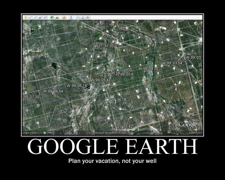
Positional Accuracy of the Google Earth Imagery In The Gaza Strip
 Positional Accuracy of the Google Earth Imagery In The Gaza Strip Maher A. El-Hallaq Associate Professor of Surveying Civil Engineering Department The Islamic University of Gaza, Palestine mhallaq@iugaza.edu.ps
Shape e o f f the e Earth
 1 Coordinate Systems & Projections Coordinate Systems Two map layers are not going to register spatially unless they are based on the same coordinate system. 2 Contents Shape of the earth Datum Projections
Ground Truth Annual Conference. Optimized Design of Low Distortion Projections. Michael L. Dennis, RLS, PE
 Arizona Professional Land Surveyors Association 016 Annual Conference Ground Truth Optimized Design of Low Distortion Projections Michael L. Dennis, RLS, PE Version 3 (rev 1), May 016 Design and metadata
What Do You See? FOR 274: Forest Measurements and Inventory. Area Determination: Frequency and Cover
 What Do You See? Message of the Day: Many options exist to determine the size, area, or extent of a feature on a landscape FOR 274: Forest Measurements and Inventory Lecture 7: Measures of Land Area Frequency
A PRIMER ON COORDINATE SYSTEMS Commonly Used in Michigan
 A PRIMER ON COORDINATE SYSTEMS Commonly Used in Michigan David P. Lusch, Ph.D., GISP Department of Geography Remote Sensing & GIS Research and Outreach Services Group Michigan State University September,
Working with georeferenced data. What is georeferencing? Coordinate Systems. Geographic and Projected Coordinate System
 GIS501 Fundamentals of Geographical Information Systems (GIS) Coordinate Systems Working with georeferenced data What is georeferencing? Geographically referenced data which is, in some way, referenced
April 24, :00 to 5:00 p.m.
 Datums, Coordinate Systems, Low Distortion Projections (LDP), & the Global Spatial Data Model (GSDM) Hosted by: City of Las Cruces Public Works/Project Development and Community Development/GIS April 24,
ELECTRONICS DIVISION INTERNAL REPORT NO. 324
 NATIONAL RADIO ASTRONOMY OBSERVATORY Green Bank, West Virginia ELECTRONICS DIVISION INTERNAL REPORT NO. 324 NRAO 43m Antenna Coordinates and Angular Limits (Version 4) Glen Langston September 14, 2012
Dr. ABOLGHASEM AKBARI Faculty of Civil Engineering & Earth Resources, University Malaysia Pahang (UMP)
") Workshop on : Dr. ABOLGHASEM AKBARI Faculty of Civil Engineering & Earth Resources, University Malaysia Pahang (UMP) 14-15 April 2016 Venue: Tehran, Iran GIS definitions GIS: A simplified view of the real
Workshop on : Dr. ABOLGHASEM AKBARI Faculty of Civil Engineering & Earth Resources, University Malaysia Pahang (UMP) 14-15 April 2016 Venue: Tehran, Iran GIS definitions GIS: A simplified view of the real
Coordinate Systems and Datum Transformation in ArcGIS. Brittney White and Melita Kennedy
 Coordinate Systems and Datum Transformation in ArcGIS Brittney White and Melita Kennedy Where is my data? Problem Horizontal Vertical Projections Transformations Horizontal coordinate systems Geographic
WHERE ARE YOU? Maps & Geospatial Concepts Fall 2012
 WHERE ARE YOU? Maps & Geospatial Concepts Fall 2012 Where are you? Relative location I m at school Absolute Location 45 26 18.07 122 43 50.78 Datums Datums A reference surface of the Earth Used as the
The National Spatial Reference System of the Future
 The National Spatial Reference System of the Future William Stone Southwest Region (AZ, NM, NV, UT) Geodetic Advisor william.stone@noaa.gov NOAA s National Geodetic Survey geodesy.noaa.gov Salt Lake City
Understanding Projections for GIS
 Presented by John Schaeffer Juniper GIS Services, Inc. This PowerPoint is available at JuniperGIS.com Presentation Objectives To understand basic concepts on projections and coordinate systems for the
Spatial Reference Systems. Introduction
 Spatial Reference Systems Wolfgang Kainz Professor of Cartography and Geoinformation Department of Geography and Regional Research University of Vienna wolfgang.kainz@univie.ac.at Introduction Historic
1/28/16. EGM101 Skills Toolbox. Oblate spheroid. The shape of the earth Co-ordinate systems Map projections. Geoid
 EGM101 Skills Toolbox Oblate spheroid The shape of the earth Co-ordinate systems Map projections The geoid is the shape that the surface of the oceans would take under the influence of Earth's gravitation
Coordinate systems, measured surveys for BIM, total station for BIM, as-built surveys, setting-out
 Coordinate systems, measured surveys for BIM, total station for BIM, as-built surveys, setting-out What is a BIM What does a BIM do Why use a BIM BIM Software BIM and the Surveyor How do they relate to
MODERNIZATION OF THE NSRS
 NATRF 2022 AND LDP SEPTEMBER 12, 2017 MODERNIZATION OF THE NSRS Why? Leaving passive control marks behind and relying solely on the CORS network for 3D positions: Older methodology relies on terrestrial
CE 316 GEOMATICS COURSE NOTES DR. MOIR D HAUG, C.L.S., P. ENG. JANUARY 2012
 CE 316 GEOMATICS COURSE NOTES DR. MOIR D HAUG, C.L.S., P. ENG. JANUARY 2012 0 COURSE INFORMATION Dr Moir D Haug, P. Eng University Office 2B25 Engineering 966 5355 moir.haug@usask.ca MDH Engineered Solutions
Lecture 4. Coordinate Systems & Projections
 Lecture 4 Coordinate Systems & Projections Outline Geodesy Geoids Ellipsoids Geographic Coordinate Systems Magnetic North vs. True North Datums Projections Applying Coordinate Systems and Projections Why
The Nature of Spatial Data. Keith C. Clarke Geography UCSB
 The Nature of Spatial Data Keith C. Clarke Geography UCSB Geographic primitives G = g (x, y, z, s, A, t) [x, y, z] = f(λ, φ, d) Geography also highly dependent upon model First, the datum (d) Models of
Town of Chino Valley. Survey Control Network Report. mgfneerhg mc N. Willow Creek Road Prescott AZ
 Town of Chino Valley Survey Control Network Report mgfneerhg mc. 2050 N. Willow Creek Road Prescott AZ 86301 928-771-2376 Page 1 of 70 Table of Contents Town of Chino Valley Survey Datum Outline A short
Lecture 10-14: Map Projections and Coordinate System
 URP 1281 Surveying and Cartography Lecture 10-14: Map Projections and Coordinate System December 27, 2015 Course Teacher: Md. Esraz-Ul-Zannat Assistant Professor Department of Urban and Regional Planning
SECTION 1: Identification Information
 Page 1 of 5 Home Data Catalog Download Data Data Status Web Services About FAQ Contact Us SECTION 1: Identification Information Originator: University of Minnesota-Duluth Geology Department; MN Geological
Fundamentals of Surveying (LE/ESSE )
") Fundamentals of Surveying (LE/ESSE 2620 3.0) Lecture 2 Basics of Surveying Dr.-Ing. Jian-Guo Wang Geomatics Engineering York University Fall 2017 1 2-1. Overview Part 1: Basics - The Earth s Shape & Size.
Fundamentals of Surveying (LE/ESSE 2620 3.0) Lecture 2 Basics of Surveying Dr.-Ing. Jian-Guo Wang Geomatics Engineering York University Fall 2017 1 2-1. Overview Part 1: Basics - The Earth s Shape & Size.
WHERE ARE YOU? Maps & Geospatial Concepts Fall 2015
 WHERE ARE YOU? Maps & Geospatial Concepts Fall 2015 Where are you? Relative location I m at school Absolute Location 45 26 18.07 122 43 50.78 Where is Boston? Introducing Geodesy, Ellipsoids & Geoids Geodesy
Mobile Mapping Tips and Tricks
 Mobile Mapping Tips and Tricks Projections, Datums and Geoids, May 2017 Introduction This guide is designed to provide a basic understanding of coordinate system projections, datums and geoids. The guide
Basics of GIS reviewed
 Basics of GIS reviewed Martin Breunig Karlsruhe Institute of Technology martin.breunig@kit.edu GEODETIC INSTITUTE, DEPARTMENT OF CIVIL ENGINEERING, GEO AND ENVIRONMENTAL SCIENCES, CHAIR IN GEOINFORMATICS
Georeferencing. Place names Postal addresses Postal codes Coordinate systems (lat/long, UTM, etc.)
") Georeferencing Georeferencing Used to describe the act of assigning locations to data or information Certain requirements include that they are: unique, have shared meaning, and are persistent through
Georeferencing Georeferencing Used to describe the act of assigning locations to data or information Certain requirements include that they are: unique, have shared meaning, and are persistent through
Ground Truth Annual Conference. Design and Documentation of Low Distortion Projections for Surveying and GIS
 Professional Land Surveyors of Oregon 15 Annual Conference Ground Truth Design and Documentation of Low Distortion Projections for Surveying and GIS Michael L Dennis, RLS, PE v. (rev 1), January 15, Design
Spatial Data Collection using GPS: BEST PRACTICES
 Spatial Data Collection using GPS: BEST PRACTICES - 2007 Page 1 of 10 Best practices for GPS & Spatial Data Collection, Storage and Documentation These Best Practices are designed to maximize positional
KEYSTONE PROPERTY GRAVITY GIS DATABASE. Residual Gravity Looking Down to Northwest
 KEYSTONE PROPERTY GRAVITY - 2018 GIS DATABASE Residual Gravity Looking Down to Northwest James L. Wright M.Sc. May 11, 2018 TABLE OF CONTENTS INTRODUCTION......................... 2 SURVEY PROCEDURE......................
Version 1.1 GIS Syllabus
 GEOGRAPHIC INFORMATION SYSTEMS CERTIFICATION Version 1.1 GIS Syllabus Endorsed 1 Version 1 January 2007 GIS Certification Programme 1. Target The GIS certification is aimed at: Those who wish to demonstrate
Map Projections. What does the world look like? AITOFF AZIMUTHAL EQUIDISTANT BEHRMANN EQUAL AREA CYLINDRICAL
 Map Projections What does the world look like? AITOFF AZIMUTHAL EQUIDISTANT BEHRMANN EQUAL AREA CYLINDRICAL 1 CYLINDRICAL EQUAL AREA BONNE CRASTER PARABOLIC 2 ECKERT I ECKERT III ECKERT V There are many
Boolean Operators and Topological OVERLAY FUNCTIONS IN GIS
 Boolean Operators and Topological OVERLAY FUNCTIONS IN GIS Query asking a question of the attribute data Standard Query Language (SQL) is used to query the data There are 4 basic statements used to get
UNITED NATIONS E/CONF.97/6/IP. 33
 UNITED NATIONS E/CONF.97/6/IP. 33 ECONOMIC AND SOCIAL COUNCIL Seventeenth United Nations Regional Cartographic Conference for Asia and the Pacific Bangkok, 18-22 September 2006 Item 7 of the provisional
Fundamentals of Surveying (LE/ESSE ) Lecture 10
 Lecture 10") Fundamentals of Surveying (LE/ESSE 2620 3.0) Lecture 10 Topographic Mapping Dr.-Ing. Jianguo Wang Geomatics Engineering York University Fall 2017 1 10-1 Introduction Two main types of maps: Line maps Orthophotographic
Fundamentals of Surveying (LE/ESSE 2620 3.0) Lecture 10 Topographic Mapping Dr.-Ing. Jianguo Wang Geomatics Engineering York University Fall 2017 1 10-1 Introduction Two main types of maps: Line maps Orthophotographic
SPOT DEM Product Description
 SPOT DEM Product Description Version 1.1 - May 1 st, 2004 This edition supersedes previous versions Acronyms DIMAP DTED DXF HRS JPEG, JPG DEM SRTM SVG Tiff - GeoTiff XML Digital Image MAP encapsulation
Geog Lecture 29 Mapping and GIS Continued
 Geog 1000 - Lecture 29 Mapping and GIS Continued http://scholar.ulethbridge.ca/chasmer/classes/ Today s Lecture (Pgs 13-25, 28-29) 1. Hand back Assignment 3 2. Review of Dr. Peddle s lecture last week
Reservoirs to Regions
 Reservoirs to Regions A Geodetic Approach to Scalable Visualization without Distortion Noel Zinn Geodetics and Cartography ExxonMobil Exploration Company Version 3 / 12 July 25 Reservoirs to Regions v3
Metadata for 2005 Orthophotography Products
 Metadata for 2005 Orthophotography Products What does this data set describe? 1. How should this data set be cited? 2. What geographic area does the data set cover? 3. What does it look like? 4. Does the
The Wildlife Society Meet and Greet. Come learn about what the UNBC Student Chapter of TWS is all about!
 Georeferencing I GEOG 300, Lecture 4 Dr. Anthony Jjumba 1 The Wildlife Society Meet and Greet Quiz Come learn about what the UNBC Student Chapter of TWS is all about! 5:30 7:30 PM, Wednesday September
4 Survey Datums. 4.1 Horizontal Datum Policy SURVEY DATUMS SEPTEMBER 2006
 4 Survey Datums Today s multi-organizational Project Development efforts require the use of common, accurate horizontal and vertical survey datums and consistent, precise control-survey procedures to ensure
The 3-D Global Spatial Data Model: Geometrical Foundation of the Global Spatial Data Infrastructure
 The 3-D Global Spatial Data Model: Geometrical Foundation of the Global Spatial Data Infrastructure Earl F. Burkholder, PS, PE Annotated Table of Contents July 8,2006 I. The Global Spatial Data Model (GSDM)
What s Up? Tidal and Vertical Datums. Noel Zinn Hydrometronics LLC July 2011, revised November 2013
 What s Up? Tidal and Vertical Datums Noel Zinn Hydrometronics LLC www.hydrometronics.com July 2011, revised November 2013 1 Motivation The real world is three-dimensional, therefore, coordinates are necessarily
GRAVITY SURVEY TEELS MARSH PROSPECT
 GRAVITY SURVEY over the TEELS MARSH PROSPECT MINERAL COUNTY, NV for Dajin Resources (US) Corp. March 2015 SUBMITTED BY Magee Geophysical Services LLC 465 Leventina Canyon Road Reno, Nevada 89523 USA TEL
Importance of Understanding Coordinate Systems and Map Projections.
 Importance of Understanding Coordinate Systems and Map Projections. 1 It is extremely important that you gain an understanding of coordinate systems and map projections. GIS works with spatial data, and,
Butte County Fire Department
 Butte County Fire Department Basic Land Navigation Verification Sheet I verify that Print Supervisor s name has completed the Print Employee s name Basic Land Navigation self study guide on. Date Attached
Chapter 3: Configuring Geodetics & Units
 Chapter 3: Configuring Geodetics & Units WinFrog provides you with the ability to configure the Working Geodetics to suit survey requirements for almost any location worldwide. The configuration of the
2. GETTING STARTED WITH GIS
 2. GETTING STARTED WITH GIS What are geographic information systems and what are they used for? ArcGIS: ArcMap, ArcCatalog and ArcToolbox Vector data vs. raster data vs. attribute tables Polygons, polylines,
Conformal Projections In Geodesy And Cartography (United States. Coast And Geodetic Survey. Special Publication) By Paul D Thomas
 By Paul D Thomas") Conformal Projections In Geodesy And Cartography (United States. Coast And Geodetic Survey. Special Publication) By Paul D Thomas www.ngs.noaa.gov - the United States. Coast and Geodetic Survey, Special
Conformal Projections In Geodesy And Cartography (United States. Coast And Geodetic Survey. Special Publication) By Paul D Thomas www.ngs.noaa.gov - the United States. Coast and Geodetic Survey, Special
Map Projections & Coordinate Systems
 Map Projections & Coordinate Systems 9/7/2017 1 Why? Laying the Earth Flat Need convenient means of measuring and comparing distances, directions, areas, shapes. Traditional surveying instruments measure
CPR 514 Term Paper Haitham Alsahfy G
 CPR 514 Term Paper 2011 Haitham Alsahfy G201001540 Submitted to : Dr. Bager Al Ramadan Date : 1/1/2012 Abstract: GIS is a fundamental tool for success in Oil and Gas exploration operations. It usually
ARES ENERGY, LTD. SDI Survey Report. Fuhrman-Mascho Andrews County, Texas (Grid North) University 13 #2H VH - Job # KW-204.
 University 13 #2H VH - Job # KW-204.") ARES ENERGY, LTD. Fuhrman-Mascho Andrews County, Texas (Grid North) University 13 #2H VH - Job #320214-KW-204 Survey: Gyro SDI Survey Report 17 February, 2014 SDI SDI Survey Report Company: ARES ENERGY,
ARES ENERGY, LTD. Fuhrman-Mascho Andrews County, Texas (Grid North) University 13 #2H VH - Job #320214-KW-204 Survey: Gyro SDI Survey Report 17 February, 2014 SDI SDI Survey Report Company: ARES ENERGY,