Fundamentals of Surveying (LE/ESSE ) Lecture 10
|
|
|
- Geoffrey Francis
- 6 years ago
- Views:
Transcription
1 Fundamentals of Surveying (LE/ESSE ) Lecture 10 Topographic Mapping Dr.-Ing. Jianguo Wang Geomatics Engineering York University Fall
2 10-1 Introduction Two main types of maps: Line maps Orthophotographic image maps This lecture focus on The characteristics and construction of topographic maps in conventional line and digital formats Methods for representing relief This lecture covers Datum for Mapping Reference Coordinate Systems for Mapping Representation of Relief Contours and Contour Lines Types of topographic maps Topographic Data Collection, Processing and Plotting Map scales, accuracy Topographic Map Symbols 2
3 10-1 Introduction History Some of the earliest known maps were made in Mesopotamnia, in the area now known as Iraq, where a series of maps showing property boundaries were drawn in about 2400 B.C. for the purpose of land taxation. A Roman map dating from about A.D. showed such topographical features as roads, cities, rivers, and mountains. In 1539, the Dutch mathematician and geographer Reiner Gemma Frisius described a method for surveying an area by dividing it into triangles. This concept of triangulation became one of the basic techniques of field surveying and is still used today. One of the first large-scale mapping projects using triangulation was started in the 1670s by Giovanni Domenico Cassini, who had been persuaded to make a detailed map of France. After his death, his children and grandchildren continued to labor on the project. The final result, called the Carte de Cassini, was published in 1793 and was the first accurate topographic map of an entire country. 3
4 10-1 Introduction History The concept of contour lines to show different elevations on a map was developed by the French engineer J.L. Dupain-Triel in Although this method allowed the accurate depiction of land contours and elevations on a flat, two-dimensional map, it was not widely used until the mid-1800s. The USGS (U.S. Geological Survey) began using aerial photography techniques to produce and update maps in 1930s. In the 1980s the use of computers to scan and redraw existing maps significantly reduced the time required to update maps in areas of rapid growth. On Topographic Maps The word topography is derived from the Greek words topos, meaning a place, and graphien, meaning to write. Thus, topography is the written, or drawn, description of a place. 4
5 10-1 Introduction On Topographic Maps (cont d) A topographic map is a two-dimensional representation of a threedimensional land surface. Topographic Maps show (by using suitable symbols) 1) the spatial characteristics of the Earth s surface, with such natural features: mountains, hills, valleys, vegetation, forests, lakes, and rivers etc. 2) constructed features: cities, buildings, road, canals, bridges and cultivation etc. 3) Valuable reference information for surveyors and map makers: bench marker, base lines and meridians, magnetic declinations etc. Topographic maps are differentiated from other maps; show both the horizontal and vertical positions of the terrain the representation of the terrain relief. Topographic maps are used by civil engineers, environmental managers, urban planners, emergency services, and national defense etc. Topographic maps are geo-referenced! need for a geodetic datum, coordinate systems etc. 5
 topographic maps - the orthophotos Sample")
 NTS 41J/2 (Sample), Blind River, Ontario")
6 10-1 Introduction Products of topographic maps - the (paper) topographic maps - the orthophotos Sample Topographic Maps NTS 82O (Sample), Banff, Alberta, (1/ ) NTS 41J/2 (Sample), Blind River, Ontario (1/50 000) 6

7 10-1 Introduction Sample Topographic Maps Engineering design map prepared using CADD system [pp. 501, Elementary Surveying] 7
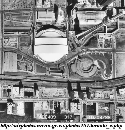
8 10-1 Introduction Sample Orthophotos 8

9 10-1 Introduction Samples: 3D Topographic Maps Topographic map, draped over DTM with added hill-shading. Source: Petrovič, Mašera,

10 10-1 Introduction Samples: 3D Topographic Maps 10

11 10-1 Introduction Samples: 3D Topographic Maps 11
12 10-2 Datum for Mapping 1. Datum Standards A datum defines the position of the ellipsoid relative to the center of the earth. provides a frame of reference for measuring locations on the surface of the earth by defining the origin and orientation of latitude and longitude lines. relates positions, directions and elevations measured in the field to global reference systems ( geo-referencing!). Ensures that the surveys and adjustments over a wide geographic area will be consistent with each other. Whenever you change the datum, or more correctly, the definition of the used geographic coordinate system, the coordinate values of your data will change. 2. Datum Horizontal & vertical. A country or a group of countries have maintained their own datum(s). Local datum, such as the North American Datum of 1983 (NAD 83), is designed to be used in a specific area. Datum transformations are required when survey data cross such regional boundaries with different datums. 12
13 10-2 Datum for Mapping 3. A Horizontal Datum consists of - an ellipsoid of revolution approximating the figure of the earth and - a set of constants or constraints that specify the size, position, and orientation of the ellipsoid. 4. A vertical Datum is the surface to which elevations or depths are referred. 5. Examples: Horizontal Datum 1). NAD27: The North American Datum of 1927 uses the Clarke 1866 spheroid to represent the shape of the earth. The origin of this datum is Meades Ranch in Kansas. Many NAD 1927 control points were calculated from observations taken in the 1800s. These calculations were done manually and in sections over many years. The result of this approach was errors between stations. 2). NAD83: The horizontal control datum for the United States, Canada, Mexico, and Central America - based on a geocentric origin and the Geodetic Reference System based upon both earth and satellite observations, using the GRS80 spheroid. The center of this datum is the center of the earth. - Locations between NAD27 and NAD83 shift by as much as 500 feet, however NAD 83 is compatible with GPS data - based on the adjustment of 250,000 points including 600 satellite Doppler stations which constrain the system to a geocentric origin. 13
14 10-2 Datum for Mapping 5. Examples: Horizontal Datum (cont d) 3). WGS84: the World Geodetic System of is the reference frame used by the U.S. Department of Defense (DoD) - is defined by the National Imagery and Mapping Agency (NIMA) (formerly the Defense Mapping Agency). - is used by DoD for all its mapping, charting, surveying, and navigation needs, including its GPS "broadcast" and "precise" orbits. - was defined in January 1987 using Doppler satellite surveying techniques. - was used as the reference frame for broadcast GPS Ephemerides (orbits) beginning January 23, At 0000 GMT January 2, 1994, WGS 84 was upgraded in accuracy using GPS measurements. The formal name then became WGS 84 (G730) since the upgrade date coincided with the start of GPS Week became the reference frame for broadcast orbits on June 28, At 0000 GMT September 30, 1996 (the start of GPS Week 873), WGS 84 was redefined again and was more closely aligned with International Earth Rotation Service (IERS) Terrestrial Reference Frame (ITRF) is now formally called WGS 84 (G873). WGS 84 (G873) was adopted as the reference frame for broadcast orbits on January 29,
15 10-2 Datum for Mapping 6. Examples: Vertical Datum 1). CGVD28: Canadian Geodetic Vertical Datum of the previous official Canadian height system - System has become obsolete, a new system underway. - The adoption of a new vertical datum for Canada could be as early as The only viable alternative (long-term) for Canada is a geoid model - would define the datum in relation to an ellipsoid, making it compatible with space-based technologies for positioning 2). CGVD2013 in Canada The current official Canadian height system A Geoid-based vertical datum released in 2013, defined by the equipotential surface ( W 0 = ,0m 2 s 2 ), which represents by convention the coastal mean sea level for North America. This definition comes from an agreement between the United States of America and Canada. This new vertical datum is realized by the geoid model CGG2013, which provides the separation between the GRS80 ellipsoid and the above described surface in NAD83(CSRS) reference frame, making it compatible with Global Navigation Satellite Systems (GNSS) such as GPS. 15
16 10-3 Reference Coordinate Systems for Mapping Two types of coordinate systems be used to locate features on the earth 1. Geographic coordinate system defines locations using latitude and longitude on a spherical model of the earth: the ellipsoid (includes angular unit of measure, central meridian, datum) Horizontal Datum in Surveying For example: NAD83 in north America WGS84 2. Projected coordinate system Being used by GPS defines locations as x, y (or Easting, Northing) coordinates identified on a grid using a mathematical conversion from latitude and longitude (includes unit of measure, an equally spaced grid, origin at the center x = 0, y = 0) For example: UTM 6 degree zones worldwide (UTM Grids) MTM 3 degree zones FACTS: i). On the same datums (NAD83 & CGVD2013), inclusive of heights ii). A different form of coordinates 16


17 10-4 Representation of Relief - relief models - 3D perspective views with wire frame - shaded rendering or draped imagery - contour lines - cross sections, profiles, hachures or form lines Hachures Automatically plotted contours Three-dimensional perspective terrain model 17
18 10-5 Contours and Contour Lines 1. A contour: an imaginary line of constant elevation on the ground surface. 2. Contour interval: the fixed vertical distance between successive contours representing elevation difference on a given map - depends on map scale, the degree of relief and user s needs 3. Contours and relief 18
")
19 10-5 Contours and Contour Lines 3. Contours and relief (cont d) 19
20 10-5 Contours and Contour Lines 3. Contours and relief (cont d) The Characteristics of Contour lines: a. All of the points on the same contour line have the identical height; b. All contour lines must close on themselves either within or outside the border of the map; c. No contour lines with different elevations cannot merge or cross one another on the map unless a steep cliff or a steep chute is reached; d. A contour line is perpendicular to the lines of steepest slope, such as the mountain ridge lines, ravine(valley) lines; e. The horizontal distance between contour lines is inversely proportional to slope. The larger slop one has in an area, the more closely spaced contour lines one will see there. The contour lines are spaced uniformly on uniform slopes. 20
21 10-5 Contours and Contour Lines 4. Types of Contour lines 1) The intermediate contour line is drawn based on the contour interval, the basic contour line; 2) The index contour line is drawn thicker than the intermediate one after 4 intermediate lines; 3) The supplementary contour line is drawn every half contour interval as user s needs. 21
22 10-6 Information shown on maps General information for any map: 1) The direction of the meridian and basis for directions. 2) A graphical scale of the map and a corresponding note stating the scale at which the map was produced. 3) A legend or key to symbols other than the conventional ones. 4) An appropriate title. 5) A statement of the contour interval on topographic maps. 6) A statement giving the datums to which horizontal and vertical control referenced. 7) A statement giving the map projection, together with the projection parameters in cases where they are not widely known. 8) A statement giving the coordinate system for which grid lines or grid ticks are shown on the map. 9) The date on which the map was produced, and the dates of any revisions. 10) A statement about the source of data used to compile the map, and the date of acquisition of such source data. 11) A sketch showing the location of the map sheet in a series of sheets covering a project area or municipal region. Some other information: (e.g.) a map as a public record of land division should have Surveyor s certification and registration number etc. 22
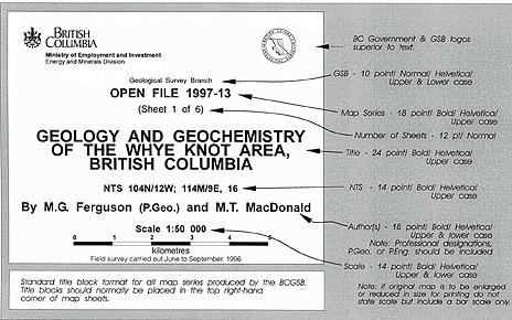
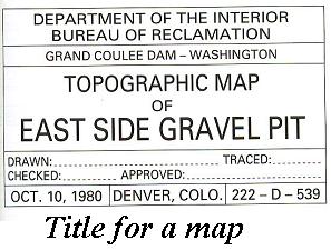
23 10-6 Information shown on maps 23
24 10-7 Mapping Scales, Contour intervals and Accuracies 1. Classification of topographic maps - Large scale: 1:10,000 and over (1:500, 1:1000, 1:2000, 1:5000, 1:10,000) E.g.: Ontario Digital Topographic Database: 1:10,000 - Medium scale: 1:100,000 ~ 1:25,000 (e.g.: 1:25,000, 1:50,000, 1:100,000) E.g.: National Topographic System (NTS) of Canada: 1:50,000, 100km 2 /sheet Ontario Digital Topographic Database: 1:20,000 - Small scale: 1:200,000 and smaller (1:200,000; 1:250,000; 1:500,000; 1:1000,000) E.g.: NTS: 1:250,000, 16 sheets of NTS 1:50, Contour intervals 24
25 10-7 Mapping Scales, Contour intervals and Accuracies 2. Contour intervals 25
26 10-7 Mapping Scales, Contour intervals and Accuracies 3. Accuracy of a topographic map - General rule: The distance on the ground corresponding to the visual resolution of human eyes: 0.1mm on maps (hard copy of maps). Scale accuracy of large scale mapping Map scale 1:500 1:1000 1:2000 1:5000 1:10,000 Scale accuracy [cm] cm (map)/km (ground) General Instructions for Surveys, Chapter D13 BASEMAPPING Canada Centre for Cadastral Management, Recommended Scale 1:1,000 1:2,000 1:5,000 1:10,000 1:20,000 Accuracy Requirement [m] Application dependent! 26
27 10-7 Mapping Scales, Contour intervals and Accuracies 3. Accuracy of a topographic map (cont d) - NMAS (National Map Accuracy Standards): Horizontal accuracy: no more than 10% of well-defined points be in error by more than 0.8mm at published map scale. Well-defined points: those that are easily visible or recoverable on the ground those that can be plotted at the map scale to within 0.25mm. For example: map scale 1:20,000 16m as horizontal accuracy tolerance Vertical accuracy: no more than 10% of elevations shall be in error by more than one-half the published contour interval. - Standards for large scale maps: uses the root mean square error (rms) MSE MSE Planimetric coordinate accuracy for well-defined points; class I maps Map scale 1:50 1:100 1:500 1:1000 1:2000 1:4000 1:5000 1:10,000 Planimetric limiting RMS (X or Y) [m] [( x τ ) n [( y τ ) = n x y 2 2 ] = x, y the measured coordinates from the maps ] τ the known value of x or y of checkpoints n the number of points tested
28 10-8 Topographic Data Collection, Processing and Plotting 1. Data collection Main one is photogrammetry direct field survey for small projects: total station and GPS 2. Computer-aided drafting and design 3. GIS and digital mapping 4. Data processing Design of map layout selection of map projection manipulation of map data selection of features preparation of collar information border, titles, scales, legends, graticules labels of features preparation of manuscript 28


29 10-9 Topographic Map Symbols 1. Standards and Specifications for Polychrome Maps NTS Symbols are defined based on this standard! ( 29
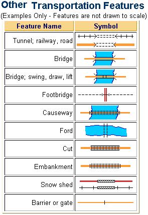
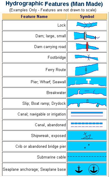
30 10-9 Topographic Map Symbols 30
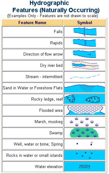
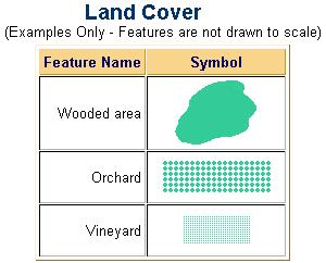
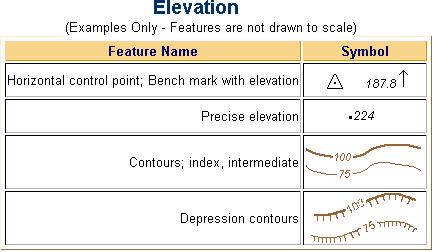
31 10-9 Topographic Map Symbols 31

32 10-9 Topographic Map Symbols 32
33 10-9 Topographic Map Symbols 2. The USGS Symbols 3. Topographic Symbols (page 494, Surveying Theory and Practice) 33
34 10-10 Further Topics 1. Canada NTS Grid Map (homework). 2. Ontario Digital Topographic Database (homework) 3. Digital Terrain Models 4. Photogrammetric Mapping 5. GIS 6. Cadastral Mapping 34
Georeferencing, Map Projections, Cartographic Concepts. -Coordinate Systems -Datum
 Georeferencing, Map Projections, Cartographic Concepts -Map Projections -Coordinate Systems -Datum Map projection is "the process of systematically transforming positions on the Earth's spherical surface
Geog Lecture 29 Mapping and GIS Continued
 Geog 1000 - Lecture 29 Mapping and GIS Continued http://scholar.ulethbridge.ca/chasmer/classes/ Today s Lecture (Pgs 13-25, 28-29) 1. Hand back Assignment 3 2. Review of Dr. Peddle s lecture last week
Chapter 1 Overview of Maps
 Chapter 1 Overview of Maps In this chapter you will learn about: Key points when working with maps General types of maps Incident specific maps Map legend and symbols Map sources A map is a navigational
Height Modernization 2013 A New Canadian Vertical Datum
 Height Modernization 2013 A New Canadian Vertical Datum What is Height Modernization? The Height Reference System Modernization is a project at the Geodetic Survey Division (GSD) of Natural Resources Canada
Shape e o f f the e Earth
 1 Coordinate Systems & Projections Coordinate Systems Two map layers are not going to register spatially unless they are based on the same coordinate system. 2 Contents Shape of the earth Datum Projections
REFERENCING COORDINATE SYSTEMS MAP PROJECTIONS GEOREFERENCING
 GIS in Ecology SPATIAL REFERENCING COORDINATE SYSTEMS MAP PROJECTIONS GEOREFERENCING : :1 Where on earth? Early mapmakers recognized the need for a system that could locate features on the earth's surface.
Topographic Maps and Landforms Geology Lab
 Topographic Maps and Landforms Geology Lab Ray Rector: Instructor Today s Lab Activities 1) Discussion of Last Week s Lab 2) Lecture on Topo Maps and Elevation Contours 3) Construct Topographic Maps and
This week s topics. Week 6. FE 257. GIS and Forest Engineering Applications. Week 6
 FE 257. GIS and Forest Engineering Applications Week 6 Week 6 Last week Chapter 8 Combining and splitting landscape features and merging GIS databases Chapter 11 Overlay processes Questions? Next week
B. Topographic maps are also called. contour maps
 Topographic Maps Introduction A. Topographic maps are essential tools in geologic and engineering studies because they show the configuration of Earth's surface in remarkable detail and permit one to measure
Boolean Operators and Topological OVERLAY FUNCTIONS IN GIS
 Boolean Operators and Topological OVERLAY FUNCTIONS IN GIS Query asking a question of the attribute data Standard Query Language (SQL) is used to query the data There are 4 basic statements used to get
What is Geodesy? Types of Geodesy terrestrial or classical geodesy space geodesy theoretical geodesy
 What is Geodesy? Geodesy is the study of: The size, shape and motion of the earth The measurement of the position and motion of points on the earth's surface, and The study of the earth's gravity field
Lecture 9: Reference Maps & Aerial Photography
 Lecture 9: Reference Maps & Aerial Photography I. Overview of Reference and Topographic Maps There are two basic types of maps? Reference Maps - General purpose maps & Thematic Maps - maps made for a specific
Positional Accuracy of the Google Earth Imagery In The Gaza Strip
 Positional Accuracy of the Google Earth Imagery In The Gaza Strip Maher A. El-Hallaq Associate Professor of Surveying Civil Engineering Department The Islamic University of Gaza, Palestine mhallaq@iugaza.edu.ps
APPENDIX A GLOSSARY. Appendix A.1
 APPENDIX A GLOSSARY Appendix A.1 Appendix A.2 Back Bearing A back bearing is measured from the object to your position. It is the exact opposite of a direct bearing. Base Line An imaginary line on the
Fundamentals of Surveying (LE/ESSE )
") Fundamentals of Surveying (LE/ESSE 2620 3.0) Lecture 2 Basics of Surveying Dr.-Ing. Jian-Guo Wang Geomatics Engineering York University Fall 2017 1 2-1. Overview Part 1: Basics - The Earth s Shape & Size.
Fundamentals of Surveying (LE/ESSE 2620 3.0) Lecture 2 Basics of Surveying Dr.-Ing. Jian-Guo Wang Geomatics Engineering York University Fall 2017 1 2-1. Overview Part 1: Basics - The Earth s Shape & Size.
SURVEYING Chapter 1 Introduction
 PHILADELPHIA UNIVERSITY Faculty of Engineering. Department of Civil Engineering. SURVEYING Chapter 1 Introduction Surveying : the art or science of measuring and representing natural and artificial features
Hydrology and Floodplain Analysis, Chapter 10
 Hydrology and Floodplain Analysis, Chapter 10 Hydrology and Floodplain Analysis, Chapter 10.1 Introduction to GIS GIS Geographical Information System Spatial Data Data linked with geographical location
Mapping Earth. How are Earth s surface features measured and modeled?
 Name Mapping Earth How are Earth s surface features measured and modeled? Before You Read Before you read the chapter, think about what you know about maps Record your thoughts in the first column Pair
Mapping coordinate systems
 Mapping coordinate systems 1. The Earth's Graticule Latitude and Longitude The graticule is the imaginary grid of lines running east-west (lines of latitude = parallels) and north-south lines of longitude
Chapter 3 Models of the Earth. 3.1 Finding Locations on the Earth. 3.1 Objectives
 Chapter 3 Models of the Earth 3.1 Finding Locations on the Earth 3.1 Objectives Explain latitude and longitude. How can latitude and longitude be used to find locations on Earth? How can a magnetic compass
UNITED NATIONS E/CONF.96/CRP. 5
 UNITED NATIONS E/CONF.96/CRP. 5 ECONOMIC AND SOCIAL COUNCIL Eighth United Nations Regional Cartographic Conference for the Americas New York, 27 June -1 July 2005 Item 5 of the provisional agenda* COUNTRY
CE 316 GEOMATICS COURSE NOTES DR. MOIR D HAUG, C.L.S., P. ENG. JANUARY 2012
 CE 316 GEOMATICS COURSE NOTES DR. MOIR D HAUG, C.L.S., P. ENG. JANUARY 2012 0 COURSE INFORMATION Dr Moir D Haug, P. Eng University Office 2B25 Engineering 966 5355 moir.haug@usask.ca MDH Engineered Solutions
Using Map and Compass Together
 Using Map and Compass Together In situations where you foresee a potential evacuation on foot, where there are no roads, and no indication as to the direction of travel (i.e., road signs), it is recommended
Geographic coordinate systems
 1 Geographic coordinate systems In this chapter you ll learn about longitude and latitude. You ll also learn about the parts that comprise a geographic coordinate system including Spheres and spheroids
12/26/2012. Geographic Information Systems * * * * GIS (... yrezaei
 ( - Geographic Information Systems ( ( 1 2 3 Information System Data base DB IS IS DB (Knowledge ( ( (System (Information System - (Georefrence Analysis Data + Knowledge ======== Information 4 5 ( < 10%
A PRIMER ON COORDINATE SYSTEMS Commonly Used in Michigan
 A PRIMER ON COORDINATE SYSTEMS Commonly Used in Michigan David P. Lusch, Ph.D., GISP Department of Geography Remote Sensing & GIS Research and Outreach Services Group Michigan State University September,
Laboratory Exercise #2 Introduction to Quadrangle Maps
 page - Laboratory Exercise #2 Introduction to Quadrangle Maps A. Introduction to Quadrangle Maps The United States Geological Survey has developed a nationwide series of quadrangle maps that cover small
GEOMATICS ENGINEERING / SURVEYING
 1 GEOMATICS ENGINEERING / SURVEYING CHAPTER 1 Dr. Muhammad Ashraf Javid Assistant Professor Department of Civil and Environmental Engineering Email: muhammad.javid@unizwa.edu.om 2 Geomatics Engineering
DATA APPLIANCE FOR ARCGIS
 DATA APPLIANCE FOR ARCGIS Data Appliance for ArcGIS Provides Access to Multi-Scale Basemaps Down to Medium Scale Levels Worldwide And Large Scale for Most of the World The Data Appliance includes Several
Projections & GIS Data Collection: An Overview
 Projections & GIS Data Collection: An Overview Projections Primary data capture Secondary data capture Data transfer Capturing attribute data Managing a data capture project Geodesy Basics for Geospatial
Version 1.1 GIS Syllabus
 GEOGRAPHIC INFORMATION SYSTEMS CERTIFICATION Version 1.1 GIS Syllabus Endorsed 1 Version 1 January 2007 GIS Certification Programme 1. Target The GIS certification is aimed at: Those who wish to demonstrate
GIST 3300 / Geographic Information Systems. Last Time. Today
 GIST 3300 / 5300 Last Time Ellipsoids and Datums Today Map Projections Map Projections Today we will build on the concepts of Geographic Coordinate Systems, Ellipsoids and Datums and add the concepts of
EUROPEAN COMPUTER DRIVING LICENCE. GIS Cartography. Syllabus
 EUROPEAN COMPUTER DRIVING LICENCE GIS Cartography Syllabus Purpose This document details the syllabus for ECDL GIS Module 1 Cartography. The syllabus describes, through learning outcomes, the knowledge
Canadian Digital Elevation Data
 Natural Resources Canada Geomatics Canada Ressources naturelles Canada Géomatique Canada Canadian Digital Elevation Data Standards and Specifications Centre for Topographic Information Customer Support
CHAPTER EXIT CHAPTER. Models of Earth. 3.1 Modeling the Planet. 3.2 Mapmaking and Technology. 3.3 Topographic Maps CHAPTER OUTLINE
 EXIT CHAPTER.1 Modeling the Planet.2 Mapmaking and Technology. Topographic Maps CHAPTER OUTLINE CHAPTER.1 Modeling the Planet A flat of Earth is a convenient tool, but it can distort the shape, distance,
What Do You See? FOR 274: Forest Measurements and Inventory. Area Determination: Frequency and Cover
 What Do You See? Message of the Day: Many options exist to determine the size, area, or extent of a feature on a landscape FOR 274: Forest Measurements and Inventory Lecture 7: Measures of Land Area Frequency
GEOGRAPHIC COORDINATE SYSTEMS
 GEOGRAPHIC COORDINATE SYSTEMS Introduction to GIS Winter 2015 What is Georeferencing? Used to establish a location on the Earth s surface 1 st order polynomial transformation Georeferencing toolbar What
EnvSci360 Computer and Analytical Cartography
 EnvSci360 Computer and Analytical Cartography Lecture 3 Geodesy Map Projections, Datums, and Coordinate Systems 1 Geodesy The science of measuring and representing the shape and size of the earth, and
Georeferencing. Place names Postal addresses Postal codes Coordinate systems (lat/long, UTM, etc.)
") Georeferencing Georeferencing Used to describe the act of assigning locations to data or information Certain requirements include that they are: unique, have shared meaning, and are persistent through
Georeferencing Georeferencing Used to describe the act of assigning locations to data or information Certain requirements include that they are: unique, have shared meaning, and are persistent through
Laboratory Exercise #2 Introduction to Quadrangle Maps
 page - 1 Laboratory Exercise #2 Introduction to Quadrangle Maps A. Introduction to Quadrangle Maps The United States Geological Survey has developed a nationwide series of quadrangle maps that cover small
Georeferencing. Where on earth are we? Critical for importing and combining layers for mapping
 Georeferencing Where on earth are we? Critical for importing and combining layers for mapping 1. The Geoid Earth is not a perfect sphere, it is ellipsoidal.. earth is the 'Geoid'. The difference between
Geo Referencing & Map projections CGI-GIRS 0910
 Geo Referencing & Map projections CGI-GIRS 0910 Where are you? 31UFT8361 174,7 441,2 51 58' NB 5 40' OL 2/60 Who are they? 3/60 Do geo data describe Earth s phenomena perfectly? Georeference systems ellipsoid
Spatial Reference Systems. Introduction
 Spatial Reference Systems Wolfgang Kainz Professor of Cartography and Geoinformation Department of Geography and Regional Research University of Vienna wolfgang.kainz@univie.ac.at Introduction Historic
BUILDING AN ACCURATE GIS
 BUILDING AN ACCURATE GIS 2006 GIS in the Rockies Denver, Colorado September 13, 2006 William E. Linzey United States Department of Commerce National Oceanic and Atmospheric Administration National Geodetic
Lab Topographic Maps. Name: Partner: Purpose. Background Information
 Lab Topographic Maps Name: Partner: Purpose The purpose of this lab is to familiarize you with graphic representations of the Earth s surface primarily maps. Simple line maps show the spatial relationship
Topographic Map Series:
 DEFINITION OF A MAP A MAP IS A GEOGRAPHIC PREPRESENTATION OF A PORTION OF THE EARTH S SURFACE DRAWN TO SCALE, AS SEEN FROM ABOVE. IT S USES COLORS, SYMBOLS AND LABELS TO REPRESENT FEATURES FOUND ON THE
History of Cartography,
 Maps History of Cartography, the art and science of making maps ~2300 BC ~600 BC Early oldest known maps: Babylonian clay tablets. Greek and Roman Ptolemy s (about AD 85-165) "world map" depicted the Old
Popular Mechanics, 1954
 Introduction to GIS Popular Mechanics, 1954 1986 $2,599 1 MB of RAM 2017, $750, 128 GB memory, 2 GB of RAM Computing power has increased exponentially over the past 30 years, Allowing the existence of
What is a Map Projection?
 What is a Map Projection? It is how we represent a three dimensional Earth on a flat piece of paper However The process of transferring information from the Earth to a map causes every projection to distort
DOWNLOAD PDF THE GEOGRAPHICAL INTERPRETATION OF TOPOGRAPHICAL MAPS.
 Chapter 1 : Topography - Wikipedia â Topographical maps are large-scale maps, they show a great deal of details about the relief. â In Topographical survey, actual survey is carried out and different methods
4 Survey Datums. 4.1 Horizontal Datum Policy SURVEY DATUMS SEPTEMBER 2006
 4 Survey Datums Today s multi-organizational Project Development efforts require the use of common, accurate horizontal and vertical survey datums and consistent, precise control-survey procedures to ensure
DATA SOURCES AND INPUT IN GIS. By Prof. A. Balasubramanian Centre for Advanced Studies in Earth Science, University of Mysore, Mysore
 DATA SOURCES AND INPUT IN GIS By Prof. A. Balasubramanian Centre for Advanced Studies in Earth Science, University of Mysore, Mysore 1 1. GIS stands for 'Geographic Information System'. It is a computer-based
Geographic Information Systems class # 1 February 19, Coordinate reference systems in GIS: geodetic coordinates
 Geographic Information Systems class # 1 February 19, 2013 Coordinate reference systems in GIS: geodetic coordinates Manuel Campagnolo ISA Manuel Campagnolo (ISA) GIS/SIG 2012 2013 February 19, 2013 1
Chapter 02 Maps. Multiple Choice Questions
 Chapter 02 Maps Multiple Choice Questions 1. Every projection has some degree of distortion because A. a curved surface cannot be represented on a flat surface without distortion. B. parallels and meridians
Introduction to Contour Maps
 Your web browser (Safari 7) is out of date. For more security, comfort and Activityengage the best experience on this site: Update your browser Ignore Introduction to Contour Maps What information does
MAP STUDY: INTERPRETATION OF SURVEY MAPS
 MAP STUDY: INTERPRETATION OF SURVEY MAPS Types and Elements of Maps Maps are drawn to represent the Earth on a piece of paper. Maps are used widely to represent the Earth. Maps use signs and symbols in
Digital Topographic Mapping With Two Different Scales Using GPS And GIS On Adindan (Sudan) Datum
 Datum") INTERNATIONAL JOURNAL OF TECHNOLOGY ENHANCEMENTS AND EMERGING ENGINEERING RESEARCH, VOL 1, ISSUE 1 42 Digital Topographic Mapping With Two Different Scales Using GPS And GIS On Adindan (Sudan) Datum Abd
INTERNATIONAL JOURNAL OF TECHNOLOGY ENHANCEMENTS AND EMERGING ENGINEERING RESEARCH, VOL 1, ISSUE 1 42 Digital Topographic Mapping With Two Different Scales Using GPS And GIS On Adindan (Sudan) Datum Abd
Digital Elevation Models (DEM)
") Digital Elevation Models (DEM) Digital representation of the terrain surface enable 2.5 / 3D views Rule #1: they are models, not reality Rule #2: they always include some errors (subject to scale and data
Digital Elevation Models (DEM) Digital representation of the terrain surface enable 2.5 / 3D views Rule #1: they are models, not reality Rule #2: they always include some errors (subject to scale and data
Making Sense of Evolving Reference Frames for North America
 Making Sense of Evolving Reference Frames for North America Mike Craymer Geodetic Survey Division, Natural Resources Canada Giovanni Sella U.S. National Geodesy Survey American Geophysical Union 2007 Joint
Town of Chino Valley. Survey Control Network Report. mgfneerhg mc N. Willow Creek Road Prescott AZ
 Town of Chino Valley Survey Control Network Report mgfneerhg mc. 2050 N. Willow Creek Road Prescott AZ 86301 928-771-2376 Page 1 of 70 Table of Contents Town of Chino Valley Survey Datum Outline A short
Control Surveys and Coordinate Systems
 Control Surveys and Coordinate Systems The Earth is Round Basic Shape of the Earth: Oblate Spheroid of Revolution The length of the equatorial axis is approximately 27 miles greater than the polar axis.
1/28/16. EGM101 Skills Toolbox. Map types. Political Physical Topographic Climate Resource Road. Thematic maps (use one of the above as backdrop)
") EGM101 Skills Toolbox Map types Political Physical Topographic Climate Resource Road Thematic maps (use one of the above as backdrop) Map Types Deriving information from maps Hydrographic Geological Soils
EGM101 Skills Toolbox Map types Political Physical Topographic Climate Resource Road Thematic maps (use one of the above as backdrop) Map Types Deriving information from maps Hydrographic Geological Soils
GEOID UNDULATIONS OF SUDAN USING ORTHOMETRIC HEIGHTS COMPARED WITH THE EGM96 ANG EGM2008
 GEOID UNDULATIONS OF SUDAN USING ORTHOMETRIC HEIGHTS COMPARED Dr. Abdelrahim Elgizouli Mohamed Ahmed* WITH THE EGM96 ANG EGM2008 Abstract: Positioning by satellite system determine the normal height above
What is a map? A Map is a two or three-dimensional model or representation of the Earth s surface. 2-Dimensional map
 What is a map? A Map is a two or three-dimensional model or representation of the Earth s surface. 2-Dimensional map What is a Map Projection? Planar Projection Projection A Projection is a mathematical
Introduction to Geographic Information Science. Updates/News. Last Lecture. Geography 4103 / Map Projections and Coordinate Systems
 Geography 4103 / 5103 Introduction to Geographic Information Science Map Projections and Coordinate Systems Updates/News Thursday s lecture Reading discussion 1 find the readings online open questions,
Understanding Projections for GIS
 Presented by John Schaeffer Juniper GIS Services, Inc. This PowerPoint is available at JuniperGIS.com Presentation Objectives To understand basic concepts on projections and coordinate systems for the
Geo Referencing & Map projections CGI-GIRS 0910
 Geo Referencing & Map projections CGI-GIRS 0910 Where are you? 31UFT8361 174,7 441,2 51 58' NB 5 40' OL 2/60 Who are they? 3/60 Do geo data describe Earth s phenomena perfectly? Georeference systems ellipsoid
Modern Navigation. Thomas Herring
 12.215 Modern Navigation Thomas Herring Today s Class Latitude and Longitude Simple spherical definitions Geodetic definition: For an ellipsoid Astronomical definition: Based on direction of gravity Relationships
THE CADASTRAL INFORMATION SYSTEM IN THE REPUBLIC OP SOUTH AFRICA
 I $:? Distr.: LIMITED ECA/NRD/CART.9/ORG.27 November 1996 Original: ENGLISH Ninth United Nations Regional Cartographic Conference for Africa Addis Ababa, Ethiopia 11-15 November 1996 THE CADASTRAL INFORMATION
Lecture 2. Map Projections and GIS Coordinate Systems. Tomislav Sapic GIS Technologist Faculty of Natural Resources Management Lakehead University
 Lecture 2 Map Projections and GIS Coordinate Systems Tomislav Sapic GIS Technologist Faculty of Natural Resources Management Lakehead University Map Projections Map projections are mathematical formulas
Height systems. Rudi Gens Alaska Satellite Facility
 Rudi Gens Alaska Satellite Facility Outline Why bother about height systems? Relevant terms Coordinate systems Reference surfaces Geopotential number 2 Why bother about height systems? give a meaning to
King County Explorer Search and Rescue. Course B Map & Compass
 King County Explorer Search and Rescue Course B Map & Compass Disclaimer The intent of this presentation is to provide a basic overview of maps, compasses, and location finding. It is not meant to be a
Name Class Date. For each pair of terms, explain how the meanings of the terms differ.
 Skills Worksheet Chapter Review USING KEY TERMS For each pair of terms, explain how the meanings of the terms differ. 1. true north and magnetic north 2. latitude and longitude 3. equator and prime meridian
Georeferencing. Geography is the key to linking attributes. Georeferencing is the key to geography.
 Georeferencing Geography is the key to linking attributes. Georeferencing is the key to geography. Why georeferencing? Many reasons for having georeferences Many different approaches to georeferencing
OBSTACLE DATA AND ELECTRONIC TERRAIN ISSUES
 OBSTACLE DATA AND ELECTRONIC TERRAIN ISSUES Michael W. Hohm Technical Officer - AIM Air Navigation Bureau, ICAO ICAO PBN Seminar - Mexico August 24-27, 2015 Outline AIM PBN partner Obstacle Data sources
Topographic Maps. Take Notes as you view the slides
 Topographic Maps Take Notes as you view the slides Lesson Objectives Define a topographic map and state its uses. Describe how contour lines show the elevations, shape, and slope of the land. Identify
Overview key concepts and terms (based on the textbook Chang 2006 and the practical manual)
") Introduction Geo-information Science (GRS-10306) Overview key concepts and terms (based on the textbook 2006 and the practical manual) Introduction Chapter 1 Geographic information system (GIS) Geographically
Introduction Geo-information Science (GRS-10306) Overview key concepts and terms (based on the textbook 2006 and the practical manual) Introduction Chapter 1 Geographic information system (GIS) Geographically
Dr. ABOLGHASEM AKBARI Faculty of Civil Engineering & Earth Resources, University Malaysia Pahang (UMP)
") Workshop on : Dr. ABOLGHASEM AKBARI Faculty of Civil Engineering & Earth Resources, University Malaysia Pahang (UMP) 14-15 April 2016 Venue: Tehran, Iran GIS definitions GIS: A simplified view of the real
Workshop on : Dr. ABOLGHASEM AKBARI Faculty of Civil Engineering & Earth Resources, University Malaysia Pahang (UMP) 14-15 April 2016 Venue: Tehran, Iran GIS definitions GIS: A simplified view of the real
Topographic Maps: Background
 Topographic Maps: Background Introduction From Dr. Terry Swanson, University of Washington, ESS 101 Lab, Geologic Techniques, and Dr. David Kendrick, Hobart and William Smith Colleges, Geneva, NY Geoscientists
NATRF 2022 AND LDP OCTOBER 11, 2017
 NATRF 2022 AND LDP OCTOBER 11, 2017 MODERNIZATION OF THE NSRS Why? Leaving passive control marks behind and relying solely on the CORS network for 3D positions: Older methodology relies on terrestrial
Frames for the Future New Datum Definitions for Modernization of the U.S. National Spatial Reference System
 Figure 10. Horizontal position differences (in meters) between NAD 83 and ITRF 08 at time 2022.00 (January 1, 2022). Positional differences are shown for the North American and Pacific tectonic plates.
QUESTIONNAIRE THE CURRENT STATUS OF MAPPING IN THE WORLD
 QUESTIONNAIRE ON THE CURRENT STATUS OF MAPPING IN THE WORLD The questionnaire is intended to take stock of the current status of mapping in the world. The information collected will eventually be used
Geography involves the study of places: their locations, their characteristics, and how humans use and move around them.
 Physical Geography Looking at the Earth Geography involves the study of places: their locations, their characteristics, and how humans use and move around them. NEXT Physical Geography Looking at the Earth
Maps: Geography s Basic Tools
 Maps: Geography s Basic Tools What is a map? - A map is a representation of the earth s features drawn on a flat surface. - Maps use points, lines, colours, and symbols to represent the features of an
Geospatial Data Standards Considerations for the delivery of 2D and 3D spatial data February 2019
 Geospatial Data Standards Considerations for the delivery of 2D and 3D spatial data February 2019 Prepared by: GRCA Geomatics Version Date Summary of Changes Changes Made By: 1.00 March 16, 2018 Version
1/28/16. EGM101 Skills Toolbox. Oblate spheroid. The shape of the earth Co-ordinate systems Map projections. Geoid
 EGM101 Skills Toolbox Oblate spheroid The shape of the earth Co-ordinate systems Map projections The geoid is the shape that the surface of the oceans would take under the influence of Earth's gravitation
Date: UNI. world. *Dedicated to
 Name: Date: UNI IT THREE 2D and 3D model s of the natural world *Dedicated to Name: Date: ABSTRACT T AND RATIONALE A topographic map is a type of map that depicts the detail and quantitative representation
Map projections. Rüdiger Gens
 Rüdiger Gens Coordinate systems Geographic coordinates f a: semi-major axis b: semi-minor axis Geographic latitude b Geodetic latitude a f: flattening = (a-b)/a Expresses as a fraction 1/f = about 300
56H. This system allows definition of points on the Earth s surface to within 100 meters. Page 20. Navigation Systems Basics of Maps
 Grid References Many maps are provided with the standard grid overlaying them. This provides a simple and accurate method for finding features on the map. It is a network of intersecting parallel lines
ENGRG Introduction to GIS
 ENGRG 59910 Introduction to GIS Michael Piasecki March 17, 2014 Lecture 08: Terrain Analysis Outline: Terrain Analysis Earth Surface Representation Contour TIN Mass Points Digital Elevation Models Slope
UNITED NATIONS E/CONF.97/6/IP. 33
 UNITED NATIONS E/CONF.97/6/IP. 33 ECONOMIC AND SOCIAL COUNCIL Seventeenth United Nations Regional Cartographic Conference for Asia and the Pacific Bangkok, 18-22 September 2006 Item 7 of the provisional
Intro to GIS Fall 2010 Georeferencing & Map Projections
 Intro to GIS Fall 2010 Georeferencing & Map Projections SHAPE OF THE EARTH Earth's Shape Geoid: shape of earth minus topographic features (irregular due to local variations in gravity) Ellipsoid: elongated
LECTURE NOTE ENGINEERING SURVEYING
 LECTURE NOTE ENGINEERING SURVEYING LECTURE 1 Introduction: Surveying is defined as taking a general view of, by observation and measurement determining the boundaries, size, position, quantity, condition,
MAPPING THE EARTH HOW DO YOU FIND A LOCATION ON THE EARTH?
 MAPPING THE EARTH HOW DO YOU FIND A LOCATION ON THE EARTH? UNIT TOPICS TOPIC 1: LATITUDE & LONGITUDE TOPIC 2: FIELD MAPS TOPIC 3: TOPOGRAPHIC MAPS TOPIC 4: NYS LANDSCAPES TOPIC 1: LATITUDE & LONGITUDE
ELECTRONICS DIVISION INTERNAL REPORT NO. 324
 NATIONAL RADIO ASTRONOMY OBSERVATORY Green Bank, West Virginia ELECTRONICS DIVISION INTERNAL REPORT NO. 324 NRAO 43m Antenna Coordinates and Angular Limits (Version 4) Glen Langston September 14, 2012
CHAIRMAN OF THE JOINT CHIEFS OF STAFF INSTRUCTION
 CHAIRMAN OF THE JOINT CHIEFS OF STAFF INSTRUCTION J-3 CJCSI 3900.01C DISTRIBUTION: A, B, C, J POSITION (POINT AND AREA) REFERENCE PROCEDURES Reference: DODD 5105.60, 11 October 1996, National Imagery and
IMPLEMENTAION OF GIS TECHNOLOGY IN THE NILE AND ITS WADIS ABSTRACT
 IMPLEMENTAION OF GIS TECHNOLOGY IN THE NILE AND ITS WADIS Eng. NADIA M. ABD EI- SALAM 1 Dr. ABDEL AZIZ TAREK M. 2 ABSTRACT Traditional methods have been used for several years for map production of the
IC ARTICLE LAND SURVEYORS
 IC 25-21.5 ARTICLE 21.5. LAND SURVEYORS IC 25-21.5-1 Chapter 1. Definitions IC 25-21.5-1-1 Application of chapter Sec. 1. The definitions in this chapter apply throughout this article. As added by P.L.23-1991,
GEOREFERENCING, PROJECTIONS Part I. PRESENTING DATA Part II
 Week 7 GEOREFERENCING, PROJECTIONS Part I PRESENTING DATA Part II topics of the week Georeferencing Coordinate systems Map Projections ArcMap and Projections Geo-referencing Geo-referencing is the process
Compass Basics. Quick Map Basics Review For Compass Use
 Compass Basics Quick Map Basics Review For Compass Use A topographic map tells you where things are and how to get to them, whether you're hiking, biking, hunting, fishing, or just interested in the world