Coordinate systems, measured surveys for BIM, total station for BIM, as-built surveys, setting-out
|
|
|
- Frederica Dickerson
- 6 years ago
- Views:
Transcription

1 Coordinate systems, measured surveys for BIM, total station for BIM, as-built surveys, setting-out


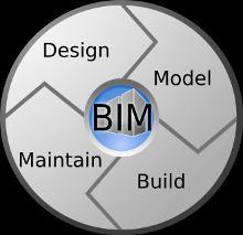
2 What is a BIM What does a BIM do Why use a BIM BIM Software BIM and the Surveyor How do they relate to us in the Surveying and Spatial industry LISTECH Neo The surveyors interface to BIM

3 The US National Building Information Model Standard Project Committee definition: Building Information Modelling (BIM) is a digital representation of physical and functional characteristics of a facility. A BIM is a shared knowledge resource for information about a facility forming a reliable basis for decisions during its life-cycle.

4
5 Currently building design works with 2D plans and 3D CAD systems - (position and elevation). BIM extends beyond 3D with: time (4D) cost (5D) Plus more In a BIM project: The professionals involved are able to access virtual information to allow data to be transferred: from the design team (architects, landscape architects, surveyors, civil, structural and building services engineers, etc.) to main contractor and subcontractors (surveyors, civil, structural and building services engineers etc.) to maintenance / refurbishment (architects, landscape architects, surveyors, civil, structural and building services engineers, etc.) It goes beyond the planning and design phases, it extends throughout the building life cycle. Efficient communications + Fluent transfer = Integrated workflow and a better finished product

6 3D Model Walk throughs Clash detection Visualisation Virtual modelling Prefabrication 4D Time Construction planning & management Schedule visualisation 5D Cost Take offs Real-time cost estimating 6D Sustainability Conceptual energy analysis and tracking 7D Facilities Management Life cycle strategies BIM As Builts
 33% reduction is costs over the lifetime of the building 47% to 65% reduction in conflicts and re-work during construction 44% to 59% increase in the overall project quality 35% to 43% reduction in")
7 Current figures show: 20% reduction in build costs (buy 4, get one free!) 33% reduction is costs over the lifetime of the building 47% to 65% reduction in conflicts and re-work during construction 44% to 59% increase in the overall project quality 35% to 43% reduction in risk, better predictability of outcomes 34% to 40% better performing completed infrastructure 32% to 38% improvement in review and approval cycles 80% of a buildings total cost in its lifecycle is maintenance To collect data on a building is 8 x more expensive after construction
8 Software designed specifically for BIM include: Bentley AECOsim Building Designer ArchiCAD Tekla Structures Autodesk Revit VectorWorks These packages have their proprietary data formats. Non-proprietary or open BIM standards BIM is associated with Industry Foundation Classes (IFCs) and aecxml IFCs have been developed by buildingsmart (the former International Alliance for Interoperability), as a neutral, non-proprietary or open standard for sharing BIM data among different software applications.


9 Surveyor: Performs As Constructed Survey Property Manager Owner Surveyor: Title Survey Builder BIM Architect Surveyor: Surveyor: Sets out Design for Builder/Contractors Contractor Engineers Existing conditions / Detail Survey
10 Issues that Surveyors will and do encounter with BIM. Coordinate Systems Measuring with Total Stations and GNSS Set out As constructed Creating Point Data Attributing
11 BIM s and the real world. BIM s a system for the management of the construction of a Building Usually on a local coordinate datum No scale factors BIM s now being used for larger infrastructure projects rail, road and other such projects that are over a larger area. Need to work in the real world Datum s and Projections Real world coordinates


 Are")
12 Geodetic Coordinates In geodetic coordinates the Earth's surface is approximated by an ellipsoid and locations near the surface are described in terms of latitude, longitude and height A map projection Is a systematic transformation of the latitudes and longitudes of locations from the surface of a sphere or an ellipsoid into locations on a plane. Projected Coordinates (Rectangular Coordinates) Are defined on a flat, two-dimensional surface.

13 GNSS units basic measure and recording of points is in Geographical Coordinates which is based on the WGS84 ellipsoid. As measurements and computations are more difficult to work with in the angular mode. we therefore convert these measurements to Rectangular Coordinates. Points are computed, displayed and recorded in a linear form. easting (X-axis) northing (Y-axis) Coordinates.
14 Issues that Surveyors deal with daily. What is a ground distance? an ellipsoid distance? a grid distance? a local distance? a plane bearing? a Grid bearing? a local bearing? Sea Level Correction? Projection Point & Line Scale Factors? Combined Scale Factor?
15 Ground distances are: measured distances between two points by either a Total Station or measuring tape. Grid distances are: measured distances that have had Slope, MSL, Geoid Separation and Scale Factor corrections applied as follows: 1. Slope Correction = Horizontal Ground Distance 2. MSL Correction = Geoid Distance 3. Geoid Separation = Ellipsoidal Distance 4. Scale Factor = Grid Distance


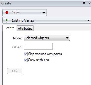
16 BIM Object based From the objects. Need to be able to create points. Attributes of the points
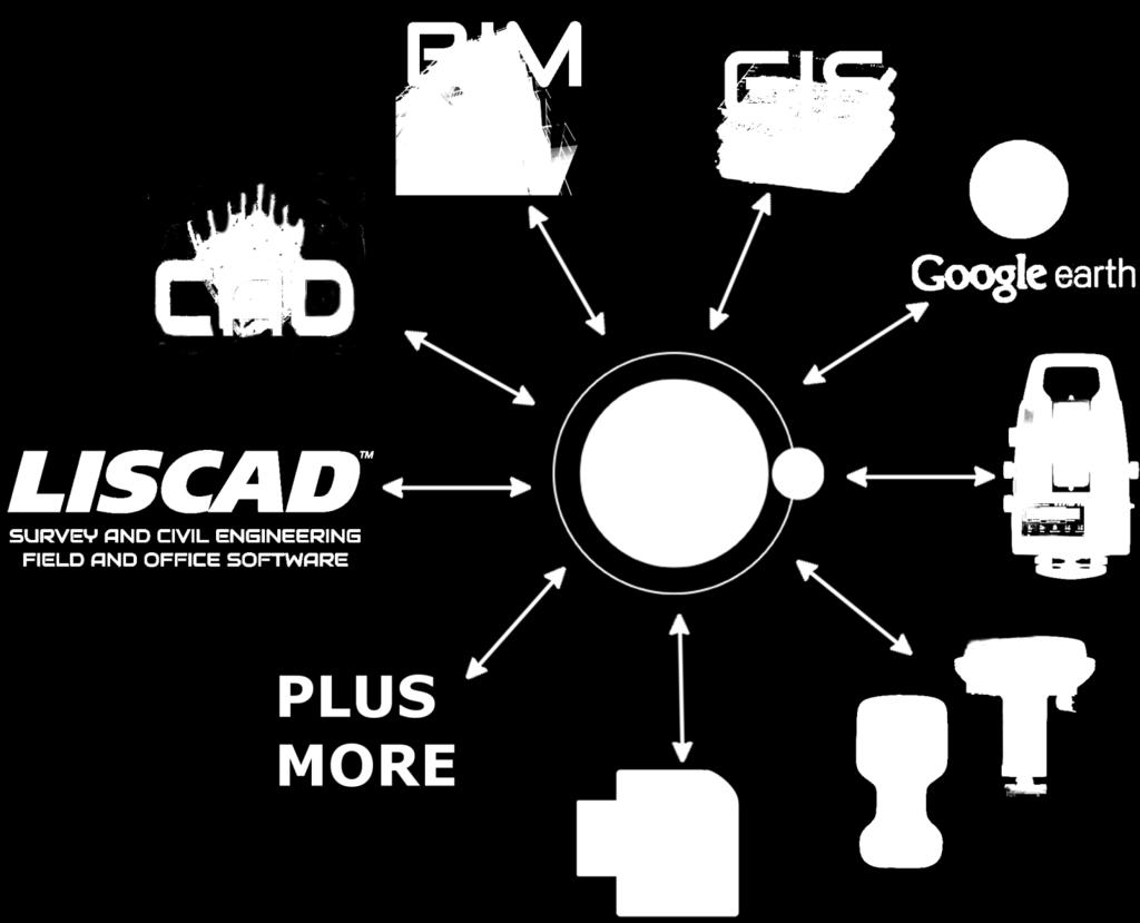
17 The Surveyors interface to BIM


18 LISTECH Neo is new generation geospatial software, offering exciting functionality with increased productivity and ease of use.
 and line styles Polygons and polygon hatching Add and")
19 Design and tailor attribute definitions to suit client needs. Points and point symbols Create attributes automatically by importing from another system Lines (made up of straight, arc and spline segments) and line styles Polygons and polygon hatching Add and edit them Annotations (text) with TrueType fonts Automatically populate with default values Integrated 3D topological database Fully self contained database (embedded file system) Optionally increment as objects are created Deliver product tailored to your client needs.
20


21


22


23 Create Objects from Total Station Imagery Key Features: Automatic Image Selection Create: System displays all images that will compute 3D objects Points Lines Polygons EpiPolar Line Makes for easy digitising on second image


24 Complete control over the processing and reduction of field surveys. Field data automatically imported Appears in Neo as on the instrument Automatic attributing Reprocess Measurements information Update dynamically Automatic Update attributing


25 Rigorous geodetic computations and editing functionality Information can be manipulated using the extensive tools available: Create Examine Modify Find Coordinate systems may be plane or geodetic. Uses known Coordinate systems or user defined. ellipsoids, projections, transformations geoid models are supported. Transformations can be performed between coordinate systems.


26
Investigating the practical relationship between GIS and BIM; then relating that to a 3D cadastre. J. Gabriel van Wyk, Johan Nel
 Investigating the practical relationship between GIS and BIM; then relating that to a 3D cadastre. J. Gabriel van Wyk, Johan Nel Overview So exactly what is BIM? Available BIM offerings in the market Traditional
Bentley Map Advancing GIS for the World s Infrastructure
 Bentley Map Advancing GIS for the World s Infrastructure Presentation Overview Why would you need Bentley Map? What is Bentley Map? Where is Bentley Map Used? Why would you need Bentley Map? Because your
E14- Integrating Civil Design, Mapping and Geospatial Data
 www.bentley.com E14- Integrating Civil Design, Mapping and Geospatial Data Lisa Whitson, Transportation and Local Infrastructure Professional Services, Bentley Systems USA GIS and Engineering Data Integration
12/26/2012. Geographic Information Systems * * * * GIS (... yrezaei
 ( - Geographic Information Systems ( ( 1 2 3 Information System Data base DB IS IS DB (Knowledge ( ( (System (Information System - (Georefrence Analysis Data + Knowledge ======== Information 4 5 ( < 10%
Features and Benefits
 Autodesk LandXplorer Features and Benefits Use the Autodesk LandXplorer software family to help improve decision making, lower costs, view and share changes, and avoid the expense of creating physical
Strategies for Integrating CAD and BIM in ArcGIS. Don Kuehne Esri 3D Product Manager: CAD/BIM/AEC
 Strategies for Integrating CAD and BIM in ArcGIS Don Kuehne Esri 3D Product Manager: CAD/BIM/AEC CAD Digital Drawing CAD in ArcGIS Desktop CAD in Desktop CAD as Data CAD as a Map EXPORT TO CAD Create and
Shape of the Earth. Data Output by the Receiver
 It is quite common for confusion to arise about the process used during a hydrographic survey when GPS-derived water surface elevation is incorporated into the data as an RTK Tide correction. This article
Your Perfect 3D World (BIM and GIS Integrated)
") Your Perfect 3D World (BIM and GIS Integrated) June 2015 Larisa Kruger Background Larisa Kruger- Enterprise GIS Manager FITS- Facilities Information Technology Services 2 years (GIS for 15) 2 FTE, 4 students
Your Perfect 3D World (BIM and GIS Integrated) June 2015 Larisa Kruger Background Larisa Kruger- Enterprise GIS Manager FITS- Facilities Information Technology Services 2 years (GIS for 15) 2 FTE, 4 students
INSPIRATION RESULTS AND BENEFITS ALBANIA
 INSPIRATION RESULTS AND BENEFITS ALBANIA By Eng. Besnik Çomo Paper prepared for E&I Workshop: Support to INSPIRE Implementation in enlargement and EWP Countries JRC ISPRA Central Office of Immovable Property
LEADS. The Essential Elements of a 3-D Geographic Coordinate
 The Essential Elements of a 3-D Geographic Coordinate John W. Dix 13 September 2005 ESRI Homeland Security GIS Summit - Denver, CO John.W.Dix@nga.mil NATIONAL GEOSPATIAL-INTELLIGENCE AGENCY Overview is
Model Setup IDM Vol 2: Process Model
 Model Setup IDM Vol 2: Process Model Gateway to Melbourne, Australia. Source: Fender Katsalidis, Architects Version 1.4 27 June 2017 Contents Model Setup Exchange Scenarios... 1 Overview... 1 Project Roles...
BUILDING AN ACCURATE GIS
 BUILDING AN ACCURATE GIS 2006 GIS in the Rockies Denver, Colorado September 13, 2006 William E. Linzey United States Department of Commerce National Oceanic and Atmospheric Administration National Geodetic
ch02.pdf chap2.pdf chap02.pdf
 Introduction to Geographic Information Systems 8th Edition Karl Solutions Manual Full Download: http://testbanklive.com/download/introduction-to-geographic-information-systems-8th-edition-karl-solutions-manu
Geographical Information System GIS
 Geographical Information System GIS LOOM.02.331 anto.aasa@ut.ee Scale GIS and spatial planning National Regional Local Strategic (National Dev. Plan) National Goals and development policy Tactical (Regional
A Broad View of Geospatial Technology & Systems
 A Broad View of Geospatial Technology & Systems Pete Large Vice President, Trimble On the shoulders of giants 1 Since their time, our ability to generate geospatial information has grown exponentially
Esri UC2013. Technical Workshop.
 Esri International User Conference San Diego, California Technical Workshops July 9, 2013 CAD: Introduction to using CAD Data in ArcGIS Jeff Reinhart & Phil Sanchez Agenda Overview of ArcGIS CAD Support
Laser Scanning Increased Confidence = Reduced Risk
 Laser Scanning Increased Confidence = Reduced Risk Matthew McCarter - Surveyor Working in survey industry 16 years Started laser scanning in 2000 Advisory committee for SPAR EU and GeoBusiness conferences
Japan Construction Information Center
 Japan Construction Information Center A Framework for Data Coordination Method of Maintenance Data and 3D Conceptual Model on CIM Based Database July 2016 Japan Construction Information Center Foundation
Projections & GIS Data Collection: An Overview
 Projections & GIS Data Collection: An Overview Projections Primary data capture Secondary data capture Data transfer Capturing attribute data Managing a data capture project Geodesy Basics for Geospatial
1 Complementary Access Tools
 ENERGY IHS AccuMap Shaped by industry and powered by IHS Markit information, AccuMap is a powerful and intuitive interpretation solution for the Canadian Energy Industry. 1 Complementary Access Tools AccuLogs
INTRODUCTION TO GEOGRAPHIC INFORMATION SYSTEM By Reshma H. Patil
 INTRODUCTION TO GEOGRAPHIC INFORMATION SYSTEM By Reshma H. Patil ABSTRACT:- The geographical information system (GIS) is Computer system for capturing, storing, querying analyzing, and displaying geospatial
Innovation. The Push and Pull at ESRI. September Kevin Daugherty Cadastral/Land Records Industry Solutions Manager
 Innovation The Push and Pull at ESRI September 2004 Kevin Daugherty Cadastral/Land Records Industry Solutions Manager The Push and The Pull The Push is the information technology that drives research and
Geog Lecture 29 Mapping and GIS Continued
 Geog 1000 - Lecture 29 Mapping and GIS Continued http://scholar.ulethbridge.ca/chasmer/classes/ Today s Lecture (Pgs 13-25, 28-29) 1. Hand back Assignment 3 2. Review of Dr. Peddle s lecture last week
Integrating BIM in the GIS World of Munich Airport. Wolfgang Haller Jan 19th, 2018
 Integrating BIM in the GIS World of Munich Airport Wolfgang Haller Jan 19th, 2018 GIS and CAD Desktop Browser. Mobile Version 12.2.1.0 Map BBA OIS KBM SIS Interfaces VisMan Web[R4] mobile VisMan Go ^^
DATA SOURCES AND INPUT IN GIS. By Prof. A. Balasubramanian Centre for Advanced Studies in Earth Science, University of Mysore, Mysore
 DATA SOURCES AND INPUT IN GIS By Prof. A. Balasubramanian Centre for Advanced Studies in Earth Science, University of Mysore, Mysore 1 1. GIS stands for 'Geographic Information System'. It is a computer-based
AEC 3 United Kingdom. Industry Foundation Classes. Norwegian IFG project Harmonisation IFC and gml3. Dr. Thomas Liebich, Jeffrey Wix AEC3 Ltd.
 Industry Foundation Classes AEC 3 United Kingdom Thatcham, Berkshire RG18 3ES Tel: +44-1635 86 4590 Fax: +44-1635 86 0673 email: jeffrey.wix@aec3.com Germany D-80636 München Tel: +49-89-1870 3223 Fax:
Bentley Map Advancing GIS for the World s Infrastructure
 Bentley Map Advancing GIS for the World s Infrastructure Presentation Overview Why would you need Bentley Map? What is Bentley Map? Where is Bentley Map Used? Red text signifies new things in Bentley Map
CAD: Introduction to using CAD Data in ArcGIS. Kyle Williams & Jeff Reinhart
 CAD: Introduction to using CAD Data in ArcGIS Kyle Williams & Jeff Reinhart What we will accomplish today Overview of ArcGIS CAD Support Georeferencing CAD data for ArcGIS How Mapping Specification for
Land-Line Technical information leaflet
 Land-Line Technical information leaflet The product Land-Line is comprehensive and accurate large-scale digital mapping available for Great Britain. It comprises nearly 229 000 separate map tiles of data
File Geodatabase Feature Class. Tags platts, price assessement, crude oil, crude, petroleum
 Major Price Assessment Points (Global) File Geodatabase Feature Class Tags platts, price assessement, crude oil, crude, petroleum Summary Visualize the price of oil around the world with these generalized
2. GETTING STARTED WITH GIS
 2. GETTING STARTED WITH GIS What are geographic information systems and what are they used for? ArcGIS: ArcMap, ArcCatalog and ArcToolbox Vector data vs. raster data vs. attribute tables Polygons, polylines,
Paths Toward CAD and GIS Interoperability
 Paths Toward CAD and GIS Interoperability Bo Guo, PhD, PE Gistic Research, Inc Outline CAD and GIS Differences Interoperability Paths UDOT ROW Research Project CAD and GIS: The Difference (I) History Users
Lesson 5: Map Scale and Projections
 Organizing Data and Information Lesson 5: Map Scale and Projections Map Scales Projections Information can be organized as lists, numbers, tables, text, pictures, maps, or indexes. Clusters of information
Pushing the Standards Edge: Collaborative Testbeds to Accelerate Standards Development and Implementation
 Pushing the Standards Edge: Collaborative Testbeds to Accelerate Standards Development and Implementation Mark E. Reichardt President mreichardt@opengeospatial.org 31 October 2006 2006 Open Geospatial
Integration Activities in Indonesia: The Integration of Land and Marine Spatial Data Sets as Part of Indonesian SDI Development
 Integration Activities in Indonesia: The Integration of Land and Marine Spatial Data Sets as Part of Indonesian SDI Development M. Arief Syafi i National Coordination Agency for Surveys and Mapping (B
Height systems. Rudi Gens Alaska Satellite Facility
 Rudi Gens Alaska Satellite Facility Outline Why bother about height systems? Relevant terms Coordinate systems Reference surfaces Geopotential number 2 Why bother about height systems? give a meaning to
Experiences and Directions in National Portals"
 FIG Seminar on e-land Administration Innsbruck/Austria 2-4 June 2004 "ESRI's Experiences and Directions in National Portals" Kevin Daugherty Cadastral/Land Records Manager ESRI Topic Points Technology
Blog. Infraworks 360 Model Creation Process. by David Crowther
 Page 1 of 6 Infraworks 360 Model Creation Process by David Crowther Cadline has a team of geospatial specialists with expertise in the integration of both CAD and GIS applications, and so were asked to
Scott A. True Project Scientist Geodesy & Geophysics Division Basic and Applied Research Office InnoVision Directorate
 EGM96 Variable Resolution Geoid Implementation Error in GEOTRANS 2.3 Scott A. True Project Scientist Geodesy & Geophysics Division Basic and Applied Research Office InnoVision Directorate Introduction
Geometric Algorithms in GIS
 Geometric Algorithms in GIS GIS Visualization Software Dr. M. Gavrilova GIS Software for Visualization ArcView GEO/SQL Digital Atmosphere AutoDesk Visual_Data GeoMedia GeoExpress CAVE? Visualization in
GEOSPATIAL ENGINEERING COMPETENCIES. Core Geospatial Competencies
 GEOSPATIAL ENGINEERING COMPETENCIES Core Geospatial Competencies Which Underpin the Chosen Specialism Revision 2018: Security mindedness added to GE CORE 02E The measurement, definition and portrayal,
GIS-based Smart Campus System using 3D Modeling
 GIS-based Smart Campus System using 3D Modeling Smita Sengupta GISE Advance Research Lab. IIT Bombay, Powai Mumbai 400 076, India smitas@cse.iitb.ac.in Concept of Smart Campus System Overview of IITB Campus
Designing GIS Databases to Support Mapping and Map Production Charlie Frye, ESRI Redlands Aileen Buckley, ESRI Redlands
 Designing GIS Databases to Support Mapping and Map Production Charlie Frye, ESRI Redlands Aileen Buckley, ESRI Redlands 1 Designing GIS Databases to Support Mapping and Map Production Charlie Frye, ESRI
State of Israel Ministry of Housing and Construction Survey of Israel. The Hydrological project case
 State of Israel Ministry of Housing and Construction Survey of Israel The Hydrological project case Survey of Israel Content Introduction To the Survey of Israel The operation assumptions The main responsibilities
Geographic Information Systems class # 1 February 19, Coordinate reference systems in GIS: geodetic coordinates
 Geographic Information Systems class # 1 February 19, 2013 Coordinate reference systems in GIS: geodetic coordinates Manuel Campagnolo ISA Manuel Campagnolo (ISA) GIS/SIG 2012 2013 February 19, 2013 1
Shale Plays. File Geodatabase Feature Class. Tags shale plays, basins, gas production, regions
 Shale Plays File Geodatabase Feature Class Tags shale plays, basins, gas production, regions Summary This layer can be used to determine geographic potential for natural gas extraction from the earth.
GEOIDS FAQ. November
 GEOIDS FAQ 1. What is a geoid? A geoid is a representation of the equipotential surface of the Earth s gravity field. It can be thought of as a surface coinciding with the undisturbed mean sea level extended
To achieve these Global Sustainable Development Goals, geospatial data are crucial.
 To achieve these Global Sustainable Development Goals, geospatial data are crucial. 2 http://www.globalgoals.org/ HIGH INCOME NATION SUSTAINABLE GROWTH SOCIALLY INCLUSIVE 3 http://etp.pemandu.gov.my/ 12
Introduction to Geographic Information Systems
 Introduction to Geographic Information Systems Lynn_Carlson@brown.edu 401-863-9917 The Environmental And Remote TecHnologies Lab MacMillan Hall, Room 105 http://www.brown.edu/research/earthlab/ Outline
ArcGIS Web Tools, Templates, and Solutions for Defence & Intelligence. Renee Bernstein Esri Solutions Engineer
 ArcGIS Web Tools, Templates, and Solutions for Defence & Intelligence Renee Bernstein Esri Solutions Engineer ArcGIS Solutions Includes 450+ Industry Focused Apps and Capabilities Organized by 9 Primary
STRICT AND AUTOMATIC MAPPING OF IFC-BIM MODELS INTO SEMANTICALLY ENRICHED 3D CITYGML BUILDING MODELS (EXTERIOR AND INTERIOR)
") STRICT AND AUTOMATIC MAPPING OF IFC-BIM MODELS INTO SEMANTICALLY ENRICHED 3D CITYGML BUILDING MODELS (EXTERIOR AND INTERIOR) 1ST INTERNATIONAL IAG WORKSHOP ON BIM AND GIS INTEGRATION 25 OCTOBER 2017 Rudi
STRICT AND AUTOMATIC MAPPING OF IFC-BIM MODELS INTO SEMANTICALLY ENRICHED 3D CITYGML BUILDING MODELS (EXTERIOR AND INTERIOR) 1ST INTERNATIONAL IAG WORKSHOP ON BIM AND GIS INTEGRATION 25 OCTOBER 2017 Rudi
The Standard Infrastructure
 GISize! The Standard Infrastructure Management Interface for Wonderware Presenter Selim Birced GISize! Introduction 2 GISize! The Standard Infrastructure Management Interface A framework designed to: Helping
Web-Based 3D Geospatial Facility Model Data Interfaces
 Web-Based 3D Geospatial Facility Model Interfaces Federal Facilities Council Symposia October 31, 2006 BIM: Grass Root Experiences Alex Viana Naval Facilities Engineering Command Washington Navy Yard,
Introduction-Overview. Why use a GIS? What can a GIS do? Spatial (coordinate) data model Relational (tabular) data model
 data model Relational (tabular) data model") Introduction-Overview Why use a GIS? What can a GIS do? How does a GIS work? GIS definitions Spatial (coordinate) data model Relational (tabular) data model intro_gis.ppt 1 Why use a GIS? An extension
Introduction-Overview Why use a GIS? What can a GIS do? How does a GIS work? GIS definitions Spatial (coordinate) data model Relational (tabular) data model intro_gis.ppt 1 Why use a GIS? An extension
Industry Trends and Direction: a quick look! John Whitehead Trimble Navigation Ltd.
 Industry Trends and Direction: a quick look! John Whitehead Trimble Navigation Ltd. Converging forces have placed geospatial information at the center of an evolving ecosystem Technology Societal Forces
Lab 1: Importing Data, Rectification, Datums, Projections, and Output (Mapping)
") Lab 1: Importing Data, Rectification, Datums, Projections, and Output (Mapping) Topics covered in this lab: i. Importing spatial data to TAS ii. Rectification iii. Conversion from latitude/longitude to
Lab 1: Importing Data, Rectification, Datums, Projections, and Output (Mapping) Topics covered in this lab: i. Importing spatial data to TAS ii. Rectification iii. Conversion from latitude/longitude to
MODERNIZATION OF THE MUNICIPAL MAPPING USING HIGH END GNSS SYSTEM AND GIS SOFTWARE
 MODERNIZATION OF THE MUNICIPAL MAPPING USING HIGH END GNSS SYSTEM AND GIS SOFTWARE Mr. R. A. R. Khan Assistant Engineer, Sewerage Utility Management Centre (SUMC) Municipal Corporation Of Greater Mumbai
Country Report on SDI Activities in Singapore *
 UNITED NATIONS E/CONF.100/CRP.9 ECONOMIC AND SOCIAL COUNCIL Eighteenth United Nations Regional Cartographic Conference for Asia and the Pacific Bangkok, 26-29 October 2009 Item 7(a) of the provisional
Fusion of Geodesy and GIS at NOAA s National Geodetic Survey
 Fusion of Geodesy and GIS at NOAA s National Geodetic Survey Esri Survey Summit July 6-9, 2013 San Diego, CA Michael Dennis, RLS, PE michael.dennis@noaa.gov The Plan Background NGS Data Explorer New Datasheet
Version 1.1 GIS Syllabus
 GEOGRAPHIC INFORMATION SYSTEMS CERTIFICATION Version 1.1 GIS Syllabus Endorsed 1 Version 1 January 2007 GIS Certification Programme 1. Target The GIS certification is aimed at: Those who wish to demonstrate
In this exercise we will learn how to use the analysis tools in ArcGIS with vector and raster data to further examine potential building sites.
 GIS Level 2 In the Introduction to GIS workshop we filtered data and visually examined it to determine where to potentially build a new mixed use facility. In order to get a low interest loan, the building
Hydrology and Floodplain Analysis, Chapter 10
 Hydrology and Floodplain Analysis, Chapter 10 Hydrology and Floodplain Analysis, Chapter 10.1 Introduction to GIS GIS Geographical Information System Spatial Data Data linked with geographical location
CWPP_Wildland_Urban_Interface_Boundaries
 Page 1 of 7 CWPP_Wildland_Urban_Interface_Boundaries Data format: Shapefile File or table name: CWPP_Wildland_Urban_Interface_Boundaries Coordinate system: Lambert Conformal Conic Theme keywords: Wildland
HIGH RESOLUTION BASE MAP: A CASE STUDY OF JNTUH-HYDERABAD CAMPUS
 HIGH RESOLUTION BASE MAP: A CASE STUDY OF JNTUH-HYDERABAD CAMPUS K.Manjula Vani, Abhinay Reddy, J. Venkatesh, Ballu Harish and R.S. Dwivedi ABSTRACT The proposed work High Resolution Base map: A Case study
Bentley Map V8i (SELECTseries 3)
") Bentley Map V8i (SELECTseries 3) A quick overview Why Bentley Map Viewing and editing of geospatial data from file based GIS formats, spatial databases and raster Assembling geospatial/non-geospatial data
Bentley Map V8i (SELECTseries 3) A quick overview Why Bentley Map Viewing and editing of geospatial data from file based GIS formats, spatial databases and raster Assembling geospatial/non-geospatial data
Introduction to GIS. Dr. M.S. Ganesh Prasad
 Introduction to GIS Dr. M.S. Ganesh Prasad Department of Civil Engineering The National Institute of Engineering, MYSORE ganeshprasad.nie@gmail.com 9449153758 Geographic Information System (GIS) Information
Inception to Completion: The Project Design Workflow. Southwest User Group April 10, 2018 Broomfield, CO
 1 Inception to Completion: The Project Design Workflow Southwest User Group April 10, 2018 Broomfield, CO 2 Tools Trimble GPS Survey grade (S6) Mapping grade (6000) Trimble V10 imaging rover Trimble Business
Sova3D - Pilot Case: Hyvinkää Architectural Competition. Internet of Spaces
 Sova3D - Pilot Case: Hyvinkää Architectural Competition SOVA3D SOVA3D offers Internet Based Services for Building Environment 3D Digitalisation. - 3D-VIRTUALMODELS - City Model - Geometry Models - BIM
Using CAD data in ArcGIS
 Using CAD data in ArcGIS Phil Sanchez and Jeff Reinhart Esri UC 2014 Technical Workshop Agenda Overview of ArcGIS CAD Support Using CAD Datasets in ArcMap Georeferencing CAD data for ArcGIS Loading CAD
Country Report On Sdi Activities In Singapore ( )
") UNITED NATIONS E/CONF.102/IP.4 ECONOMIC AND SOCIAL COUNCIL Nineteenth United Nations Regional Cartographic Conference for Asia and the Pacific Bangkok, 29 October 1 November 2012 Item 6(b) of the provisional
UNITED NATIONS E/CONF.102/IP.4 ECONOMIC AND SOCIAL COUNCIL Nineteenth United Nations Regional Cartographic Conference for Asia and the Pacific Bangkok, 29 October 1 November 2012 Item 6(b) of the provisional
GEOREFERENCING, PROJECTIONS Part I. PRESENTING DATA Part II
 Week 7 GEOREFERENCING, PROJECTIONS Part I PRESENTING DATA Part II topics of the week Georeferencing Coordinate systems Map Projections ArcMap and Projections Geo-referencing Geo-referencing is the process
Evaluation of GPS in Orthometric Heights Determination in Khartoum State (Sudan)
") Evaluation of GPS in Orthometric Heights Determination in Khartoum State (Sudan) Dr. Nagi Zomrawi Mohammed 1, Dr. Abd Elrahim Elgizouli Mohammed 2 and Engineer Osman Bakry 3 1 Sudan University of Science
Evaluation of GPS in Orthometric Heights Determination in Khartoum State (Sudan) Dr. Nagi Zomrawi Mohammed 1, Dr. Abd Elrahim Elgizouli Mohammed 2 and Engineer Osman Bakry 3 1 Sudan University of Science
NR402 GIS Applications in Natural Resources
 NR402 GIS Applications in Natural Resources Lesson 1 Introduction to GIS Eva Strand, University of Idaho Map of the Pacific Northwest from http://www.or.blm.gov/gis/ Welcome to NR402 GIS Applications in
CHAIRMAN OF THE JOINT CHIEFS OF STAFF INSTRUCTION
 CHAIRMAN OF THE JOINT CHIEFS OF STAFF INSTRUCTION J-3 CJCSI 3900.01C DISTRIBUTION: A, B, C, J POSITION (POINT AND AREA) REFERENCE PROCEDURES Reference: DODD 5105.60, 11 October 1996, National Imagery and
International Journal of Computer Science and Telecommunications [Volume 3, Issue 7, July 2012] 109. Levelling with GPS. Dr. Nagi Zomrawi Mohammed
![International Journal of Computer Science and Telecommunications [Volume 3, Issue 7, July 2012] 109. Levelling with GPS. Dr. Nagi Zomrawi Mohammed](/thumbs/94/120062601.jpg "International Journal of Computer Science and Telecommunications [Volume 3, Issue 7, July 2012] 109. Levelling with GPS. Dr. Nagi Zomrawi Mohammed") International Journal of Computer Science and Telecommunications [Volume 3, Issue 7, July 2012] 109 ling with ISSN 2047-3338 Dr. Nagi Zomrawi Mohammed Associate Professor, College of Engineering, Sudan
International Journal of Computer Science and Telecommunications [Volume 3, Issue 7, July 2012] 109 ling with ISSN 2047-3338 Dr. Nagi Zomrawi Mohammed Associate Professor, College of Engineering, Sudan
The 3-D Global Spatial Data Model: Geometrical Foundation of the Global Spatial Data Infrastructure
 The 3-D Global Spatial Data Model: Geometrical Foundation of the Global Spatial Data Infrastructure Earl F. Burkholder, PS, PE Annotated Table of Contents July 8,2006 I. The Global Spatial Data Model (GSDM)
GEOMATICS ENGINEERING / SURVEYING
 1 GEOMATICS ENGINEERING / SURVEYING CHAPTER 1 Dr. Muhammad Ashraf Javid Assistant Professor Department of Civil and Environmental Engineering Email: muhammad.javid@unizwa.edu.om 2 Geomatics Engineering
From BIM to GIS at the Smithsonian Institution
 From BIM to GIS at the Smithsonian Institution Detlef Günther-Diringer a a University of Applied Sciences, Karlsruhe, Germany; Smithsonian Fellow March August 2016; detlef.guenther-diringer@hskarlsruhe.de
Write a report (6-7 pages, double space) on some examples of Internet Applications. You can choose only ONE of the following application areas:
 on some examples of Internet Applications. You can choose only ONE of the following application areas:") UPR 6905 Internet GIS Homework 1 Yong Hong Guo September 9, 2008 Write a report (6-7 pages, double space) on some examples of Internet Applications. You can choose only ONE of the following application
UPR 6905 Internet GIS Homework 1 Yong Hong Guo September 9, 2008 Write a report (6-7 pages, double space) on some examples of Internet Applications. You can choose only ONE of the following application
SPOT DEM Product Description
 SPOT DEM Product Description Version 1.1 - May 1 st, 2004 This edition supersedes previous versions Acronyms DIMAP DTED DXF HRS JPEG, JPG DEM SRTM SVG Tiff - GeoTiff XML Digital Image MAP encapsulation
Systems Interoperability at the Port of Long Beach
 Systems Interoperability at the Port of Long Beach Tuesday, June 11, 2013 2:45 pm 4:00 pm, Garden Salon One, 2nd Fl. Presented by: Brien Green, Account Manager, Bentley Systems Daniel Lee, Business Analyst,
Systems Interoperability at the Port of Long Beach
 Systems Interoperability at the Port of Long Beach Tuesday, June 11, 2013 2:45 pm 4:00 pm, Garden Salon One, 2nd Fl. Presented by: Brien Green, Account Manager, Bentley Systems Daniel Lee, Business Analyst,
10/13/2011. Introduction. Introduction to GPS and GIS Workshop. Schedule. What We Will Cover
 Introduction Introduction to GPS and GIS Workshop Institute for Social and Environmental Research Nepal October 13 October 15, 2011 Alex Zvoleff azvoleff@mail.sdsu.edu http://rohan.sdsu.edu/~zvoleff Instructor:
DATA 301 Introduction to Data Analytics Geographic Information Systems
 DATA 301 Introduction to Data Analytics Geographic Information Systems Dr. Ramon Lawrence University of British Columbia Okanagan ramon.lawrence@ubc.ca DATA 301: Data Analytics (2) Why learn Geographic
Florida Department of Transportation s
 Controls Conference - Hyatt Regency Savannah, Georgia - April 14-18, 2013 Florida Department of Transportation s 1) Virtual R/W Application Development 2) 3D Utility Mapping for 3D Design Update John Krause,
Chapter 10: BIM for Facilitation of Land Administration Systems in Australia
 Chapter 10: BIM for Facilitation of Land Administration Systems in Australia Sam Amirebrahimi Introduction With the introduction of the concept of 3D Cadastre and extensive efforts in this area, currently
1/28/16. EGM101 Skills Toolbox. Oblate spheroid. The shape of the earth Co-ordinate systems Map projections. Geoid
 EGM101 Skills Toolbox Oblate spheroid The shape of the earth Co-ordinate systems Map projections The geoid is the shape that the surface of the oceans would take under the influence of Earth's gravitation
4D information management system for road maintenance using GIS
 icccbe 2010 Nottingham University Press Proceedings of the International Conference on Computing in Civil and Building Engineering W Tizani (Editor) 4D information management system for road maintenance
Geographers Perspectives on the World
 What is Geography? Geography is not just about city and country names Geography is not just about population and growth Geography is not just about rivers and mountains Geography is a broad field that
METADATA. Publication Date: Fiscal Year Cooperative Purchase Program Geospatial Data Presentation Form: Map Publication Information:
 METADATA CONTOURS Digital Geospatial Metadata: North Central Texas Orthophotography Identification Information Citation Originator: Publication Date: Fiscal Year 2001-2002 Title: Cooperative Purchase Program
STEREO ANALYST FOR ERDAS IMAGINE Stereo Feature Collection for the GIS Professional
 STEREO ANALYST FOR ERDAS IMAGINE Stereo Feature Collection for the GIS Professional STEREO ANALYST FOR ERDAS IMAGINE Has Your GIS Gone Flat? Hexagon Geospatial takes three-dimensional geographic imaging
Geographical Information System in Managing Mega Infrastructure Projects
 Geographical Information System in Managing Mega Infrastructure Projects Ankita Adhikary, M.Sc. Geomatics and Space Application, CEPT University Ahmedabad G eographic Information System (GIS) is a computer
Canadian Board of Examiners for Professional Surveyors Core Syllabus Item C 5: GEOSPATIAL INFORMATION SYSTEMS
 Study Guide: Canadian Board of Examiners for Professional Surveyors Core Syllabus Item C 5: GEOSPATIAL INFORMATION SYSTEMS This guide presents some study questions with specific referral to the essential
ESRI Survey Summit August Clint Brown Director of ESRI Software Products
 ESRI Survey Summit August 2006 Clint Brown Director of ESRI Software Products Cadastral Fabric How does Cadastral fit with Survey? Surveyors process raw field observations Survey measurements define high-order
Getting to Know Data Interoperability Extension for ArcGIS
 Getting to Know Data Interoperability Extension for ArcGIS Do More with Less - Improve and Automate Data Integration, the Quality Control Process, and Reporting Alexander Stepanov, GIS Architect, AFS Niels
Map projections. Rüdiger Gens
 Rüdiger Gens Coordinate systems Geographic coordinates f a: semi-major axis b: semi-minor axis Geographic latitude b Geodetic latitude a f: flattening = (a-b)/a Expresses as a fraction 1/f = about 300
June 19 Huntsville, Alabama 1
 June 19 Huntsville, Alabama 1 Real-Time Geospatial Data: The Fusion of PI and ArcGIS Enabling Smarter Facilities Management OSIsoft and Esri Mapping and Location Analytics Platform Supporting Your Use
The Integrated Mapping Solution from Autodesk: Enhancing the Value of Geospatial Information. Autodesk Infrastructure Solutions
 Autodesk Infrastructure Solutions Autodesk Map 3D Autodesk Raster Design Autodesk MapGuide The Integrated Mapping Solution from Autodesk: Enhancing the Value of Geospatial Information Introduction GIS-dependent
7 GEOMATICS BUSINESS SOLUTIONS - ANNUAL REPORT 2006
 7 GEOMATICS BUSINESS SOLUTIONS - ANNUAL REPORT 2006 The Planning and Economic Development Committee recommends the adoption of the recommendation contained in the following report November 30, 2006, from
a system for input, storage, manipulation, and output of geographic information. GIS combines software with hardware,
 Introduction to GIS Dr. Pranjit Kr. Sarma Assistant Professor Department of Geography Mangaldi College Mobile: +91 94357 04398 What is a GIS a system for input, storage, manipulation, and output of geographic