Semi-Dynamic Datum of Indonesia
|
|
|
- Nigel Barnett
- 6 years ago
- Views:
Transcription


1 Technical Seminar Reference Frame in Practice, Semi-Dynamic Datum of Indonesia H.Z. Abidin, A.B. Wijanarto, S.T. Wibowo, Susilo, J. Efendi Geospatial Information Agency, Indonesia (BIG) Sponsors: Page 1

2 Regional Tectonic of Indonesia Intersection of 3 major plates, wide range of tectonic environments, including island arc volcanism, subduction zones, and arc-continent collision Page 2


3 Seismicity of Indonesia Region High seismicity, shallow EQs mostly confined at the subduction zone Page 3
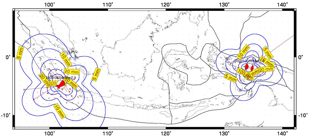
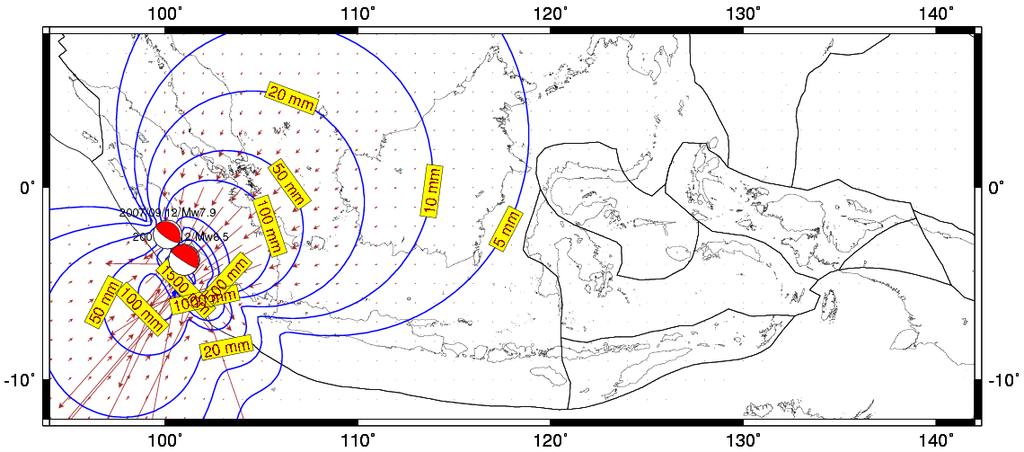
![Tectonic Complexity (Displacement) Data : Stevent et.al.,[1999/2000], Nugroho et.al., [2000]. Bock,et.al., [2003] Socquet et.](/docs-images/80/80855424/images/4-1.jpg "al., [2006], Subarja et.al.,[2007]. Abidin et al., [2007], Meilano et al., [2012] Page 4")
4 Tectonic Complexity (Displacement) Data : Stevent et.al.,[1999/2000], Nugroho et.al., [2000]. Bock,et.al., [2003] Socquet et.al., [2006], Subarja et.al.,[2007]. Abidin et al., [2007], Meilano et al., [2012] Page 4
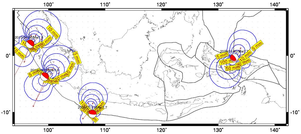
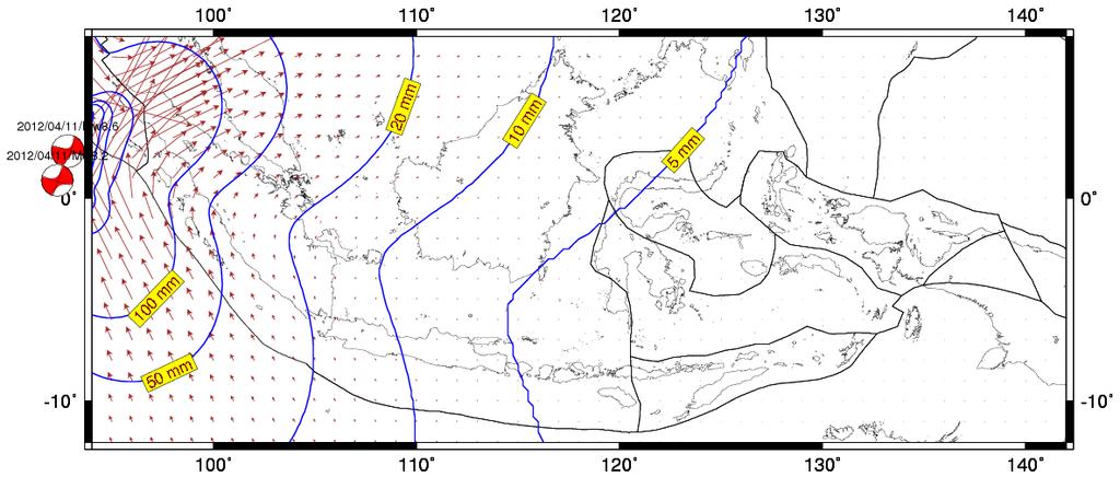
5 Displacement (mm) Displacement (mm) Coordinates displacements 3D coordinate displacements due to motion of tectonic blocks 65 cm 28 cm 620 cm 3D coordinate displacements due to earthquakes Coordinate displacements due to tectonic block motion since 1996, from GPS observations; courtesy of Meilano (ITB). Page 5
6 The Need for New Dynamic Datum A new Geodetic Datum is required to accomodate the active tectonics of Indonesian region, and also to support One-Map Policy of the Indonesian government. One Reference One Standard One Database One GeoPortal ONE-MAP POLICY Page 6

7 Geodetic Datum Page 7
8 IGRS 2013 HORIZONTAL Semi-Dynamic datum. Indonesia Geospatial Reference System 2013 Connected to the global ITRF2008 reference frame. Reference epoch: 1 January 2012 Reference Ellipsoid: WGS 1984 (a = m; 1/f = 298, ). If a new version of the ITRF reference frame becomes available, then the IGRS reference frame will also be updated accordingly. A velocity model, which incorporates tectonic motion and earthquake related deformation, is used to transform coordinates at an observation epoch to or from this reference epoch. VERTICAL Vertical datum is Geoid. The Geoid is derived from the gravity surveys which was tied to National Gravity Control Network (NGCN). NGCN has to be connected to the IGSN71 or its new version. In case there is no official Geoid yet, the vertical datum is MSL derived from 18.6 years tide observation or at least from 1 year observation. Page 8
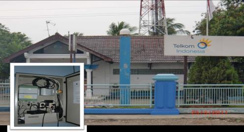
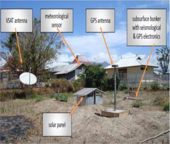
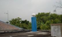
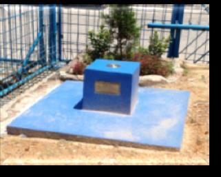
9 Realization of IGRS2013 CGPS (134) sgps (1254) Page 9


10 Deformation Model Data: cgps and sgps from Deformation Model of IGRS2013 Secular Deformation Model Page 10
11 Coseismic Deformation Model Page 11


12 Vertical Reference System Vertical Control Network Gravity Control Network Tide Gauge Stations Page 12


 The rest of Indonesia will be")
13 Geoid of Indonesia Borneo & Sulawesi Geoid derived by airborne gravity measurement conducted by DTU & BIG and need to be validated. Papua is still on processing. Other islands use MSL or EGM2008 as vertical datum Borneo Sulawesi Airborne Gravity Surveys of Java & Sumatra are set for 2018 budget (National Priority) The rest of Indonesia will be conducted in 2019 EGM2008 Page 13

14 User services and system access Web based user services to give easiness accessing SRGI2013 Type of services: Explanation of SRGI2013; Technical guide; SRGI2013, covering horizontal and vertical datum and historycal aspect as well; Description of control station; Real Time Kinematics service Other facilities supporting SRGI2013 utilization. Page 14


15 User services and system access RINEX data &RTK Service Online Tide-Gauge Information of Geoid Undulation Coordinate/epoch Transformation Information of Control Station Page 15
16 Remarks A new semi-dynamic datum for Indonesia was launched in 2013 called Indonesia Geospatial Reference System component of the IGRS2013 are horizontal geodetic datum, vertical datum, and user services and access. The horizontal deformation model was developed using GPS observation that consist secular deformation and cosesimic deformation. More detail characteristics of the local deformation in Indonesian region is necessary for updating the velocity model of IGRS By the new definition of ITRF2014, the update of IGRS2014 will be initiated Geoid as a vertical datum in Indonesia is under development. User services and system access still need to be improve Page 16
17 Technical Seminar Reference Frame in Practice, Thank you Sponsors: Page 17
On the Development and Implementations of the New Semi- Dynamic Datum for Indonesia
 On the Development and Implementations of the New Semi- Dynamic Datum for Indonesia SusiloSUSILO 1, HasanuddinZ. ABIDIN 2, IrwanMEILANO 2, Benyamin SAPEII 2 1) Center for Geodetic Control Network and Geodynamic,
On the Development and Implementations of the New Semi-Dynamic Datum for Indonesia
 On the Development and Implementations of the New Semi-Dynamic Datum for Indonesia Susilo SUSILO, Hasanuddin Z. ABIDIN, Irwan MEILANO, Benyamin SAPIIE, Indonesia Key words: geodetic datum, reference frames,
Report for 15th PCGIAP Meeting at 18th UNRCC-AP Working Group 1 Regional Geodesy
 Report for 15th PCGIAP Meeting at 18th UNRCC-AP Working Group 1 Regional Geodesy Chairman Shigeru Matsuzaka, Japan - shigeru@gsi.go.jp Vice Chairman Prof. Pengfei Cheng, China - chengpf@casm.ac.cn John
Do we need to update PNG94 to PNG2020?
 Do we need to update PNG94 to PNG2020? Richard Stanaway Quickclose Pty Ltd Robert Rosa PNG University of Technology, Lae Does PNG94 have a use by date? PNG94 is now 23 years old (reference epoch) Users
Case Study of Japan: Crustal deformation monitoring with GNSS and InSAR
 Technical Seminar Reference Frame in Practice, Case Study of Japan: Crustal deformation monitoring with GNSS and InSAR Basara Miyahara miyahara-b96ip@milt.go.jp Geospatial Information Authority of Japan
Height systems. Rudi Gens Alaska Satellite Facility
 Rudi Gens Alaska Satellite Facility Outline Why bother about height systems? Relevant terms Coordinate systems Reference surfaces Geopotential number 2 Why bother about height systems? give a meaning to
How GNSS CORS in Japan works for geodetic control and disaster mitigations
 ICG Working Group D Reference Frames, Timing and Applications How GNSS CORS in Japan works for geodetic control and disaster mitigations ICG11, Nov. 7-11, 2016, Sochi, Russia Hiromichi TSUJI Geodetic Observation
CORS Network and Datum Harmonisation in the Asia-Pacific Region. Richard Stanaway and Craig Roberts
 CORS Network and Datum Harmonisation in the Asia-Pacific Region Richard Stanaway and Craig Roberts School of Surveying and Spatial Information Systems University of New South Wales CORS Networks in the
Case study of Japan: Reference Frames in Practice
 Case study of Japan: Reference Frames in Practice Basara Miyahara and Koji Matsuo Sponsors: 1 Outline Introduction - Geodetic reference frame of Japan - GEONET : continuous GNSS observation system Geometric
CHILEAN PART OF SIRGAS REFERENCE FRAME, REALIZATION, ADOPTION, MAINTENANCE AND ACTUAL STATUS. Geodesy for Planet Earth IAG 2009, Buenos Aires
 CHILEAN PART OF SIRGAS REFERENCE FRAME, REALIZATION, ADOPTION, MAINTENANCE AND ACTUAL STATUS Geodesy for Planet Earth IAG 2009, Buenos Aires Ing. Héctor Parra hparra@igm.cl, IGM Chile Dr. Juan Báez jbaez@udec.cl,
SIRGAS: Basis for Geosciences, Geodata, and Navigation in Latin America
 SIRGAS: Basis for Geosciences, Geodata, and Navigation in Latin America Claudio Brunini President of SIRGAS Universidad Nacional de La Plata, Argentina María Virginia Mackern President of SIRGAS/WG-I:
COUNTRY REPORT THE SEVENTEENTH PERMANENT COMMITTEE ON GIS INFRASTRUCTURE FOR ASIA AND THE PACIFIC (PCGIAP) MEETING JULY 21 22, 2011,
 MEETING JULY 21 22, 2011,") COUNTRY REPORT INDONESIA ACTIVITIES IN 2010 THE SEVENTEENTH PERMANENT COMMITTEE ON GIS INFRASTRUCTURE FOR ASIA AND THE PACIFIC (PCGIAP) MEETING JULY 21 22, 2011, CHINGGIS KHAAN HOTEL, ULAANBAATAR CITY,
COUNTRY REPORT INDONESIA ACTIVITIES IN 2010 THE SEVENTEENTH PERMANENT COMMITTEE ON GIS INFRASTRUCTURE FOR ASIA AND THE PACIFIC (PCGIAP) MEETING JULY 21 22, 2011, CHINGGIS KHAAN HOTEL, ULAANBAATAR CITY,
Geographic Information Systems class # 1 February 19, Coordinate reference systems in GIS: geodetic coordinates
 Geographic Information Systems class # 1 February 19, 2013 Coordinate reference systems in GIS: geodetic coordinates Manuel Campagnolo ISA Manuel Campagnolo (ISA) GIS/SIG 2012 2013 February 19, 2013 1
NATRF 2022 AND LDP OCTOBER 11, 2017
 NATRF 2022 AND LDP OCTOBER 11, 2017 MODERNIZATION OF THE NSRS Why? Leaving passive control marks behind and relying solely on the CORS network for 3D positions: Older methodology relies on terrestrial
GEODETIC NETWORK OF SAUDI ARABIA AND FIDUCIAL STATIONS. GFN OF Saudi Arabia in Based on ITRF2000 Datum
 STUDIES OF TECTONIC MOVEMENTS IN SAUDI ARABIA USING CORS M. Al Rajhi, Ali Al Omar, R. Yanar, F. Kartal, K. Eren, SUBJECT TO TALKS BACKGROUND GEODETIC NETWORK OF SAUDI ARABIA AND FIDUCIAL STATIONS GFN OF
Positioning the Pacific: NOAA s Geospatial Activities. Juliana Blackwell, Director NOAA s National Geodetic Survey March 6, 2012
 Positioning the Pacific: NOAA s Geospatial Activities Juliana Blackwell, Director NOAA s National Geodetic Survey March 6, 2012 A Common Problem of the Early 19 th Century 1807 President Thomas Jefferson
Frames for the Future New Datum Definitions for Modernization of the U.S. National Spatial Reference System
 Figure 10. Horizontal position differences (in meters) between NAD 83 and ITRF 08 at time 2022.00 (January 1, 2022). Positional differences are shown for the North American and Pacific tectonic plates.
Next Generation Australian Datum. Permanent Committee on Geodesy, ICSM
 Next Generation Australian Datum Permanent Committee on Geodesy, ICSM 2 Presentation: Next Generation Australian Datum Trends in the geospatial sector The Geocentric Datum of Australia 1994 (GDA94) Progress
Realizing a geodetic reference frame using GNSS in the presence of crustal deformations: The case of Greece
 Realizing a geodetic reference frame using GNSS in the presence of crustal deformations: The case of Greece M. Gianniou National Cadastre and Mapping Agency S.A. Outline 1. Introduction 2. Deformation
GEOID UNDULATIONS OF SUDAN USING ORTHOMETRIC HEIGHTS COMPARED WITH THE EGM96 ANG EGM2008
 GEOID UNDULATIONS OF SUDAN USING ORTHOMETRIC HEIGHTS COMPARED Dr. Abdelrahim Elgizouli Mohamed Ahmed* WITH THE EGM96 ANG EGM2008 Abstract: Positioning by satellite system determine the normal height above
A Deformation Model to support a Next Generation Australian Geodetic Datum
 A Deformation Model to support a Next Generation Australian Geodetic Datum Richard Stanaway, Surveying and Geospatial Engineering School of Civil and Environmental Engineering multi-gnss + augmentation
Consideration of a Global Vertical Reference System (GVRS) in the IERS Conventions
 in the IERS Conventions") Consideration of a Global Vertical Reference System (GVRS) in the IERS Conventions Johannes Ihde Federal Agency for Cartography and Geodesy (BKG) Chair of IAG ICP1.2 (2003-2007) Vertical Reference Frames
Consideration of a Global Vertical Reference System (GVRS) in the IERS Conventions Johannes Ihde Federal Agency for Cartography and Geodesy (BKG) Chair of IAG ICP1.2 (2003-2007) Vertical Reference Frames
Strengthening Geospatial Information Management in Indonesia
 b Strengthening Geospatial Information Management in Indonesia Prof. Dr. Hasanuddin Z. Abidin Head (President) Geospatial Information Agency of Indonesia The 5 th High Level Forum United Nations Global
The International Terrestrial Reference System and ETRS89: Part I : General concepts
 The International Terrestrial Reference System and ETRS89: Part I : General concepts Zuheir ALTAMIMI Laboratoire de Recherche en Géodésie Institut national de l information géographique et forestière (IGN),
Military Geographic Institute
 New Chilean Reference Frame, 3 years after Maule Earthquake 90 YEARS SUPORTING THE NATIONAL DEVELOPMENT Major Julio Neira Gutierrez (MSc) Head of Geodetic Department & GDB Military Geographic Institute
NGS is Scheduled to Replace NAVD 88 and NAD 83 In 2022
 NGS is Scheduled to Replace NAVD 88 and NAD 83 In 2022 Indiana Society of Professional Land Surveyors Conference January 2017 John Ellingson NGS Geodetic Advisor john.ellingson@noaa.gov 202-306-6904 1
Height systems. Rüdiger Gens
 Rüdiger Gens 2 Outline! Why bother about height systems?! Relevant terms! Coordinate systems! Reference surfaces! Geopotential number! Why bother about height systems?! give a meaning to a value defined
Shape of the Earth. Data Output by the Receiver
 It is quite common for confusion to arise about the process used during a hydrographic survey when GPS-derived water surface elevation is incorporated into the data as an RTK Tide correction. This article
Fusion of Geodesy and GIS at NOAA s National Geodetic Survey
 Fusion of Geodesy and GIS at NOAA s National Geodetic Survey Esri Survey Summit July 6-9, 2013 San Diego, CA Michael Dennis, RLS, PE michael.dennis@noaa.gov The Plan Background NGS Data Explorer New Datasheet
Making Sense of Evolving Reference Frames for North America
 Making Sense of Evolving Reference Frames for North America Mike Craymer Geodetic Survey Division, Natural Resources Canada Giovanni Sella U.S. National Geodesy Survey American Geophysical Union 2007 Joint
Recent GNSS Developments and Reference Frame Issues in Turkey. Onur LENK and Bahadir AKTUĞ
 Recent GNSS Developments and Reference Frame Issues in Turkey Onur LENK and Bahadir AKTUĞ General Command of Mapping onur.lenk lenk@hgk.mil.tr 1/31 GPS STUDIES İN TURKEY date back to early 1990s geodynamics-oriented
The U.S. National Spatial Reference System in 2022
 Presented at the, May 29 - June 2, 2017 in The U.S. National Spatial Reference System in 2022 Daniel R. Roman, (Chief Geodesist) NOAA s National Geodetic Survey 1 Why change? Outline Naming conventions
Summary of Presentation:
 Development of Geodetic GPS Infrastructure and Its : The Malaysia Experience BY Abd Majid.A.Kadir, Shahrum Ses, Kamaluddin Omar & Abdullah Hisam Omar Fac. of Geoinformation Science and Eng. Universiti
MODERNIZATION OF THE NSRS
 NATRF 2022 AND LDP SEPTEMBER 12, 2017 MODERNIZATION OF THE NSRS Why? Leaving passive control marks behind and relying solely on the CORS network for 3D positions: Older methodology relies on terrestrial
Rigid Plate Transformations to Support PPP and Absolute Positioning in Africa
 Rigid Plate Transformations to Support PPP and Absolute Positioning in Africa Richard STANAWAY and Craig ROBERTS, Australia Key words: Rigid Plate Transformations, ITRF, Kinematic Datums, PPP SUMMARY PPP,
GEOIDS FAQ. November
 GEOIDS FAQ 1. What is a geoid? A geoid is a representation of the equipotential surface of the Earth s gravity field. It can be thought of as a surface coinciding with the undisturbed mean sea level extended
A new transformation including deformation model for the Nordic. and Baltic countries
 A new transformation including deformation model for the Nordic Presented at the FIG Working Week 2017, May 29 - June 2, 2017 in Helsinki, Finland and Baltic countries P. Häkli, M. Lidberg, L. Jivall,
Modernization of National Geodetic Datum in China *
 UNITED NATIONS E/CONF.102/IP.16 ECONOMIC AND SOCIAL COUNCIL Nineteenth United Nations Regional Cartographic Conference for Asia and the Pacific Bangkok, 29 October 1 November 2012 Item 6(b) of the provisional
Integration Activities in Indonesia: The Integration of Land and Marine Spatial Data Sets as Part of Indonesian SDI Development
 Integration Activities in Indonesia: The Integration of Land and Marine Spatial Data Sets as Part of Indonesian SDI Development M. Arief Syafi i National Coordination Agency for Surveys and Mapping (B
A Unique Reference Frame: Basis of the Global Geodetic Observing System (GGOS) for Geodynamics and Global Change
 for Geodynamics and Global Change") SRTM (InSAR) A Unique Reference Frame: Basis of the Global Geodetic Observing System (GGOS) for Geodynamics and Global Change Hermann Drewes President IAG Commission 1 Reference Frames Deutsches Geodätisches
SRTM (InSAR) A Unique Reference Frame: Basis of the Global Geodetic Observing System (GGOS) for Geodynamics and Global Change Hermann Drewes President IAG Commission 1 Reference Frames Deutsches Geodätisches
A Strategic Plan for Geodesy in Sweden. Mikael Lilje Lars E. Engberg Geodesy Department Lantmäteriet Sweden
 A Strategic Plan for Geodesy in Sweden Mikael Lilje Lars E. Engberg Geodesy Department Lantmäteriet Sweden Our vision is to be able to meet Swedish society s needs for a homogeneous, sustainable geodetic
Modernization of the National Spatial Reference System 2022 Datum. Jacksonville Chapter July 2018
 Modernization of the National Spatial Reference System 2022 Datum Jacksonville Chapter July 2018 Randy Tompkins, PSM, PLS Geomatics Project Manager Surveyor, Hydrographer, & Geodesist DRMP, Inc. Jacksonville,
PGM2016: A new geoid model for the. Philippines
 PGM2016: A new geoid model for the Philippines United Nations/Nepal Workshop on the Applications of Global Navigation Satellite Systems Kathmandu, Nepal December 12-16, 2016 Ronaldo Gatchalian, Chief Geodesy
Vertical Reference Frame Pacific
 Vertical Reference Frame Pacific Andrick Lal SPC Geoscience Division GIS&RS User Conference 29 th November 2016 USP, Fiji. What does it mean? All buildings and features have a height. But what is it relative
Inquiry: Sumatran earthquakes with GPS Earth Science Education
 Inquiry: Sumatran earthquakes with GPS Earth Science Education www.earthobservatory.sg Preparation: Before doing this investigation, complete two introductory investigations using GPS data from UNAVCO
Height Modernization 2013 A New Canadian Vertical Datum
 Height Modernization 2013 A New Canadian Vertical Datum What is Height Modernization? The Height Reference System Modernization is a project at the Geodetic Survey Division (GSD) of Natural Resources Canada
Changes are coming NGS NSRS Modernization Are you Ready?
 Changes are coming NGS 2022 - NSRS Modernization Are you Ready? Pam Fromhertz Rocky Mountain Regional Advisor Pamela.Fromhertz@noaa.gov 240-988-6363 John Hunter CO State Geomatics Coordinator DRCOG March
STUDY ON TSUNAMIGENIC EARTHQUAKE CRITERIA FOR THE INDONESIAN TSUNAMI EARLY WARNING SYSTEM
 STUDY ON TSUNAMIGENIC EARTHQUAKE CRITERIA FOR THE INDONESIAN TSUNAMI EARLY WARNING SYSTEM Nanang T. Puspito 1 1 Geophysics Research Group, Faculty of Mining and Petroleum Engineering, Institute of Technology
The Implementation of a Semi-Dynamic Datum in New Zealand Ten Years On
 The Implementation of a Semi-Dynamic Datum in New Zealand Ten Years On Graeme BLICK and Don GRANT Key words: Geodetic, Semi-Dynamic, Datum, Reference Frames SUMMARY In 1998 New Zealand implemented a new
GPS Surveying Dr. Jayanta Kumar Ghosh Department of Civil Engineering Indian Institute of Technology, Roorkee. Lecture 06 GPS Position
 GPS Surveying Dr. Jayanta Kumar Ghosh Department of Civil Engineering Indian Institute of Technology, Roorkee Lecture 06 GPS Position Friends! Welcome you to sixth class on GPS surveying. Today, I am going
Seismic Activity and Crustal Deformation after the 2011 Off the Pacific Coast of Tohoku Earthquake
 J-RAPID Symposium March 6-7, 2013 Seismic Activity and Crustal Deformation after the 2011 Off the Pacific Coast of Tohoku Earthquake Y. Honkura Tokyo Institute of Technology Japan Science and Technology
Banda Aceh December 26th Earthquake monitored by GPS
 Banda Aceh December 26th Earthquake monitored by GPS C. Vigny (1), W.J.F. Simons (2), S. Abu (3), Chalermchon Satirapod (4), M. Hashizume (5), Sarayut Yousamran (6), C. Subarya (7), K. Omar (8), H.Z. Abidin
Geodesy on the move. Craig Allinson. Dealing with dynamic coordinate reference systems. IOGP Geodesy Subcommittee. EPUG London, November 2017
 Geodesy on the move Dealing with dynamic coordinate reference systems Craig Allinson IOGP Geodesy Subcommittee EPUG London, November 2017 Why the concern? A bridge too far Historic geodesy mental image
HEIGHT SYSTEM MODERNIZATION AND GEOID MODELLING STUDIES IN TURKEY
 Presented at the FIG Congress 2018, May 6-11, 2018 in Istanbul, Turkey HEIGHT SYSTEM MODERNIZATION AND GEOID MODELLING STUDIES IN TURKEY İrem YAKAR Istanbul Technical University,Turkey TALK OUTLINE Turkey
Evaluation of GPS in Orthometric Heights Determination in Khartoum State (Sudan)
") Evaluation of GPS in Orthometric Heights Determination in Khartoum State (Sudan) Dr. Nagi Zomrawi Mohammed 1, Dr. Abd Elrahim Elgizouli Mohammed 2 and Engineer Osman Bakry 3 1 Sudan University of Science
Evaluation of GPS in Orthometric Heights Determination in Khartoum State (Sudan) Dr. Nagi Zomrawi Mohammed 1, Dr. Abd Elrahim Elgizouli Mohammed 2 and Engineer Osman Bakry 3 1 Sudan University of Science
The Impact of the 2010 Darfield (Canterbury) Earthquake on the Geodetic Infrastructure in New Zealand 1
 Earthquake on the Geodetic Infrastructure in New Zealand 1") The Impact of the 2010 Darfield (Canterbury) Earthquake on the Geodetic Infrastructure in New Zealand 1 Graeme BLICK, John BEAVAN, Chris CROOK, Nic DONNELLY Keywords: Darfield Earthquake, control, survey,
The Impact of the 2010 Darfield (Canterbury) Earthquake on the Geodetic Infrastructure in New Zealand 1 Graeme BLICK, John BEAVAN, Chris CROOK, Nic DONNELLY Keywords: Darfield Earthquake, control, survey,
Positioning in the Pacific Islands
 Positioning in the Pacific Islands Andrick Lal United Nations/Nepal Workshop on the Applications of Global Navigation Satellite Systems Kathmandu - Nepal 15 th December 2016 Presentation Outline Introduction
Roles of Geospatial Information for Disaster Risk Reduction Management in Indonesia
 Roles of Geospatial Information for Disaster Risk Reduction Management in Indonesia (Case Study: Palu-Donggala Earthquake 28 September 2018) Prof. Dr. Hasanuddin Z. Abidin Head Geospatial Information Agency
GRAVIMETRIC MAP OF CHILE. Services Mining and Engineering Geophysics Instituto Geográfico Militar
 GRAVIMETRIC MAP OF CHILE Araneda M., Rivas L., Avendaño M, Sottolichio G., Rubio W. Services Mining and Engineering Geophysics segmi@netexpress.cl) Instituto Geográfico Militar (lrivas@igm.cl) Abstract
12/07/2013. Apparent sea level rise and earthquakes
 Main collaborations: - P. Simeoni - M. N. Bouin - S. Calmant Valérie Ballu Valerie.ballu@univ-lr.fr Apparent sea level rise and earthquakes possibly the world s first community to be formally moved out
Inversion of tsunami data. A. Sladen CNRS, Géoazur 1/35
 Inversion of tsunami data A. Sladen CNRS, Géoazur 1/35 DEFINITION Tsunami waves are gravity wave with a long period need a BIG source! 2/35 DEFINITION Krakatoa, 1883 Summer 2015, E.T. pers. comm. Lituya
Case Study of Australia
 Case Study of Australia John Dawson, Geoscience Australia 1 Australia s Geodetic eco-system Geocentric Coordinates Observing Infrastructure Height Datum Geoid Models Tools Services Standards 2 Australia
NTUA, Faculty of Rural and Surveying Engineering, Dionysos Satellite Observatory, Higher Geodesy Laboratory NOA, Institute of Geodynamics 1
 NOA, Institute of Geodynamics 1 Crustal Deformation from GPS measurements at the Ionian Sea : Preliminary Results Anastasiou 1 D., Paradissis 1 D., Ganas 2 A., Marinou 1 A., Papazissi 1 K., Drakatos 2
Utilization RT-PPP in Order to Speed Up Land Parcel Registration in Indonesia Case Study Applied Trimble CenterPoint RTX in Sumatera and Java
 Utilization RT-PPP in Order to Speed Up Land Parcel Registration in Indonesia Case Study Applied Trimble CenterPoint RTX in Sumatera and Java Heri Andreas Irwan Gumilar Redy Kwee GEODESY RESEARCH GROUP
GPS Strain & Earthquakes Unit 5: 2014 South Napa earthquake GPS strain analysis student exercise
 GPS Strain & Earthquakes Unit 5: 2014 South Napa earthquake GPS strain analysis student exercise Strain Analysis Introduction Name: The earthquake cycle can be viewed as a process of slow strain accumulation
The National Spatial Reference System of the Future
 The National Spatial Reference System of the Future William Stone Southwest Region (AZ, NM, NV, UT) Geodetic Advisor william.stone@noaa.gov NOAA s National Geodetic Survey geodesy.noaa.gov Salt Lake City
Dealing with significant differential tectonic plate velocities within an RTK-network: The case of HEPOS
 Dealing with significant differential tectonic plate velocities within an RTK-network: The case of HEPOS M. Gianniou, E. Mitropoulou, I. Stavropoulou National Cadastre and Mapping Agency S.A. Mesogion
Working Group 1. Geodetic Reference Frame. Activity Report. for. The UN-GGIM-AP Plenary Meeting
 Regional Committee of United Nations Global Geospatial Information Management for Asia and the Pacific (UN-GGIM-AP) Established by a United Nations Resolution Working Group 1 Geodetic Reference Frame Activity
U.S. Datums: Where We ve Been,
 U.S. Datums: Where We ve Been, Where We re Going Modernizing the National Spatial Reference System Matt Wellslager RFA, South Carolina Geodetic Survey Presentation Outline 1. - Introductions. 2. - National
New satellite mission for improving the Terrestrial Reference Frame: means and impacts
 Fourth Swarm science meeting and geodetic missions workshop ESA, 20-24 March 2017, Banff, Alberta, Canada New satellite mission for improving the Terrestrial Reference Frame: means and impacts Richard
Geodesy. orientation. shape. gravity field
 Geodesy noun Science of measuring the shape, orientation and gravity field of the Earth and how it changes over time. shape orientation gravity field Positioning has always been important Downstream applications
Operational Aspects of GNSS CORS What is a GNSS CORS system used for?
 Please insert a picture (Insert, Picture, from file). Size according to grey field (10 cm x 25.4 cm). Scale picture: highlight, pull corner point Cut picture: highlight, choose the cutting icon from the
TSUNAMI AND EARTHQUAKE ACTIVITY IN INDONESIA *
 LOCAL TSUNAMI WARNING AND MITIGATION TSUNAMI AND EARTHQUAKE ACTIVITY IN INDONESIA * Nanang T. Puspito Department of Geophysics and Meteorology, Institute of Technology Bandung (ITB) Address: Jalan Ganeca
NGS and the Modernization of the National Spatial Reference System (NSRS)
") NGS and the Modernization of the National Spatial Reference System (NSRS) Dr. Dana Caccamise Pacific Southwest Region (CA,NV) Geodetic Advisor dana.caccamise@noaa.gov NOAA s National Geodetic Survey geodesy.noaa.gov
NGS and the Modernization of the National Spatial Reference System (NSRS) Dr. Dana Caccamise Pacific Southwest Region (CA,NV) Geodetic Advisor dana.caccamise@noaa.gov NOAA s National Geodetic Survey geodesy.noaa.gov
The Integration of Land and Marine Spatial Data Set As Part of Indonesian Spatial Data Infrastructure Development
 UNITED NATIONS E/CONF.97/6/IP. 46 ECONOMIC AND SOCIAL COUNCIL Seventeenth United Nations Regional Cartographic Conference for Asia and the Pacific Bangkok, 18-22 September 2006 Item 7 of the provisional
The Role Of Ina-SDI For Disaster Management
 The Second UN-GGIM-AP Plenary Meeting The Role Of Ina-SDI For Disaster Management Indonesia Tehran - Iran 28 October 2013 Dodi Sukmayadi Geospatial Information Authority of Indonesia (BIG) COMPONENT FOR
The Earthquake of Padang, Sumatra of 30 September 2009 scientific information and update
 The Earthquake of Padang, Sumatra of 30 September 2009 scientific information and update 01-October-2009 Christophe Vigny Directeur de recherches at CNRS Laboratoire de Géologie Geoscience Dept. Of ENS,
System of Geodetic Parameters Parametry Zemli 1990 PZ-90.11
 System of Geodetic Parameters Parametry Zemli 1990 PZ-90.11 Authors: PhD Anastasiya N. Zueva, PhD Evgeniy V. Novikov, Dr. Dmitriy I. Pleshakov, PhD Igor V. Gusev Speaker: Igor Gusev 9 th Mee'ng of the
Mobile Mapping Tips and Tricks
 Mobile Mapping Tips and Tricks Projections, Datums and Geoids, May 2017 Introduction This guide is designed to provide a basic understanding of coordinate system projections, datums and geoids. The guide
Geodesy (InSAR, GPS, Gravity) and Big Earthquakes
 and Big Earthquakes") Geodesy (InSAR, GPS, Gravity) and Big Earthquakes Mathew Pritchard Teh-Ru A. Song Yuri Fialko Luis Rivera Mark Simons UJNR Earthquake Research Panel, Morioka, Japan - Nov 6, 2002 Goals Accurate and high
Geodesy (InSAR, GPS, Gravity) and Big Earthquakes Mathew Pritchard Teh-Ru A. Song Yuri Fialko Luis Rivera Mark Simons UJNR Earthquake Research Panel, Morioka, Japan - Nov 6, 2002 Goals Accurate and high
A new geoid model for Bhutan. Machiel Bos Rui Fernandes
 A new geoid model for Bhutan Machiel Bos (machiel@segal.ubi.pt) Rui Fernandes (rui@segal.ubi.pt) June 2015 1 Definition of heights June 2015 2 Purpose of a geoid model Orthometric heights are the official
The Tectonic Setting of New Zealand
 The Tectonic Setting of New Zealand we are here Subduction-driven tectonics The New Zealand continent Papua New Guinea Australia 3,000,000 sq km micro-continent back-arc basin trench volcanism faults accretionary
Geology of the Hawaiian Islands
 Geology of the Hawaiian Islands Class 3 20 January 2004 Any Questions? IMPORTANT Big Island Field Trip We need a firm commitment PLUS $164 payment for airfare BEFORE January 29th Plate Tectonics Fundamental
Report of PCGIAP to the 18 th United Nations Regional Cartographic Conference for Asia and the Pacific (UNRCC-AP) for the period
 for the period") Permanent Committee on GIS Infrastructure for Asia and the Pacific (PCGIAP) Established in 1995 by a United Nations Resolution Report of PCGIAP to the 18 th United Nations Regional Cartographic Conference
Permanent Committee on GIS Infrastructure for Asia and the Pacific (PCGIAP) Established in 1995 by a United Nations Resolution Report of PCGIAP to the 18 th United Nations Regional Cartographic Conference
Precise Hong Kong Geoid HKGEOID-2000
 Yong-Qi Chen 1, Zhicai Luo 1 and Simon Kwok 2 1.Department of Land Surveying and Geo-Informatics, The Hong Kong olytechnic University 2 Geodetic Survey Section, Lands Department, HKSAR Abstract: This paper
TOWARDS THE IMPLEMENTATION OF SEMI-DYNAMIC DATUM FOR MALAYSIA
 TOWARDS THE IMPLEMENTATION OF SEMI-DYNAMIC DATUM FOR MALAYSIA N. S. Shariff, J. Gill, Z. M. Amin, K. M. Omar Faculty of Geoinformation and Real-Estate, Universiti Teknologi Malaysia, 81310 Skudai, Johor
LEADS. The Essential Elements of a 3-D Geographic Coordinate
 The Essential Elements of a 3-D Geographic Coordinate John W. Dix 13 September 2005 ESRI Homeland Security GIS Summit - Denver, CO John.W.Dix@nga.mil NATIONAL GEOSPATIAL-INTELLIGENCE AGENCY Overview is
Presented at the FIG Working Week 2017, May 29 - June 2, 2017 in Helsinki, Finland. ODUMOSU, Joseph O. ABIODUN, O. A KEVIN, K. M. ADAMU, G.
 Presented at the FIG Working Week 2017, May 29 - June 2, 2017 in Helsinki, Finland ODUMOSU, Joseph O. ABIODUN, O. A KEVIN, K. M. ADAMU, G. M Most Environmental Hazards are spatially related. Extent of
The Size and Duration of the Sumatra-Andaman Earthquake from Far-Field Static Offsets
 The Size and Duration of the Sumatra-Andaman Earthquake from Far-Field Static Offsets P. Banerjee, 1 F. F. Pollitz, 2 R. Bürgmann 3 * 1 Wadia Institute of Himalayan Geology, Dehra Dun, 248001, India. 2
HIMALAYAN AIRBORNE GRAVITY AND GEOID OF NEPAL
 Mt. Everest HIMALAYAN AIRBORNE GRAVITY AND GEOID OF NEPAL -Niraj Manandhar Head, Geodetic Survey Branch Survey Department, Geodetic Survey Branch Project Background Air Borne Gravity Survey Project was
4 Survey Datums. 4.1 Horizontal Datum Policy SURVEY DATUMS SEPTEMBER 2006
 4 Survey Datums Today s multi-organizational Project Development efforts require the use of common, accurate horizontal and vertical survey datums and consistent, precise control-survey procedures to ensure
FORMAT FOR TECHNICAL PAPERS
 TOWARDS A MODERNIZED GEODETIC DATUM FOR NEPAL: OPTIONS FOR DEVELOPING AN ACCURATE TERRESTRIAL REFERENCE FRAME FOLLOWING THE APRIL 25, 2015 MW7.8 GORKHA EARTHQUAKE Chris PEARSON 1, Niraj MANANDHA 2 ABSTRACT
HORIZONTAL PROJECTION PARAMETERS: DANE COUNTY COORDINATES
 Recommended RTK GPS Configuration Parameters for the City of Madison, WI Base Station Compiled by: Dan Rodman RLS, City of Madison (608)266-6674 drodman@cityofmadison.com For base station information see
New Datums: Replacing NAVD 88 and NAD 83
 New Datums: Replacing NAVD 88 and NAD 83 By Dave Zenk PE, LS National Geodetic Survey Northern Plains Regional Advisor 1735 Lake Drive West Chanhassen, MN 55317-8581 952-368-2548 office 612-414-9522 mobile
Using ArcGIS to Analyze Earthquake Patterns in Java Island, Indonesia
 Using ArcGIS to Analyze Earthquake Patterns in Java Island, Indonesia Presented By: Abdul Latif Ashadi For GIS Course (CRP 514) section 01 Instructor: Dr. Baqer M. Al-Ramadan INTRODUCTION Indonesia Region,
GEORED Project: GNSS Geodesy Network for Geodynamics Research in Colombia, South America. Héctor Mora-Páez
 GEORED Project: GNSS Geodesy Network for Geodynamics Research in Colombia, South America. Héctor Mora-Páez Colombian Geological Survey UNAVCO SCIENCE MEETING Feb 27 March 1, 2012 Boulder, CO, TECTONIC
The Global Geodetic Observing System (GGOS) of the International Association of Geodesy, IAG
 of the International Association of Geodesy, IAG") The Global Geodetic Observing System (GGOS) of the International Association of Geodesy, IAG Hans-Peter Plag (1), Markus Rothacher (2), Richard Gross (3), Srinivas Bettadpur (4) (1) Nevada Bureau of Mines
The Global Geodetic Observing System (GGOS) of the International Association of Geodesy, IAG Hans-Peter Plag (1), Markus Rothacher (2), Richard Gross (3), Srinivas Bettadpur (4) (1) Nevada Bureau of Mines
Geodetic Observing Systems: tools in observing the Glacial Isostatic Adjustment. Markku Poutanen Finnish Geodetic Institute
 Geodetic Observing Systems: tools in observing the Glacial Isostatic Adjustment Markku Poutanen Finnish Geodetic Institute Glacial Isostatic Adjustment Land uplift is just one consequence of the physical
Magnitude 7.5 PALU, INDONESIA
 A magnitude 7.5 earthquake occurred 80.8 km (50.2 mi) north of Palu, Indonesia at a depth of 10 km (6.2 miles). This earthquake triggered a tsunami with wave heights up to 2 m (6.6 ft) that an official
MSGIC Spring Mtg Denton April 23, 2014
 Modernization of the National Spatial Reference System Keeping Pace with Changes in Positioning Technology and User Expectations in a Dynamic World MSGIC Spring Mtg Denton April 23, 2014 Dave Doyle Base