Technical Support: Data Submission
|
|
|
- Horatio Wilson
- 5 years ago
- Views:
Transcription
1 Why do we want your data? How should I observe data for submission? The objective behind data submissions is to leverage ongoing field work to provide industry with an up-todate network of NAD83 (CSRS) coordinated monuments. By submitting data, you are contributing to keeping the Nova Scotia Coordinate Referencing System (NSCRS) current and accurate. This crowd sourcing technique allows maintenance to occur that otherwise could not be performed. When observing NSCMs, the following guidelines should be followed: a) Create a separate, NAD83(CSRS), UTM based job to store data for NSCMs. Heights should be ellipsoidal (no geoid model applied). b) Create a static observation survey style that will store 10 minutes of raw data at 1s observation rate. This will allow coordinate values to be verified in post-processing if discrepancies arise. c) Use a bipod or tripod rather than holding an RTK range pole. Ensure bubbles are in adjustment. d) Minimize the potential for antenna height measurement error by using a fixed height device (RTK range pole or fixed height tripod) when possible. e) Take digital photos of the Levelled bubble, Antenna height, Antenna type, Setup over mark (when using a bipod or fixed height tripod), Photos of N, E, S, W views from NSCM, and a general photo of monument site. The total allowed size for photos is 15 mb, so photo sizes should be adjusted accordingly. f) Take note of the submission requirements shown under Session Information. Including the GPS Code at the monument: GPS Code Criteria 1 Excellent Less than 10% of sky obstructed within 100 m of NSCM 2 Very Good Less than 25% of sky obstructed within 100 m of NSCM 3 Good Less than 50% of sky obstructed within 100 m of NSCM 4 Poor More than 50% sky obstructed 1
 capabilities or within a 25 km range of the nearest base station (see Technical Support 0002 NSACS Network), at least 10")
2 How long should I observe a station? How do I login to the NSCRS Viewer? If you are located within the zone of Network Real-time Kinematics (NTRK) capabilities or within a 25 km range of the nearest base station (see Technical Support 0002 NSACS Network), at least 10 minutes of observations should be logged with a 1 second observation rate. If the station is outside the NTRK zone and beyond 25 km from the nearest base station, a minimum of a 30 minute static observation should be performed with a 1 second observation rate. Credentials for the NSCRS Viewer can be obtained by submitting a request to geoinfo@novascotia.ca. In order to obtain credentials, you must: a) be a Nova Scotia Land Surveyor OR b) have a diploma in Geomatics Engineering Technology and have 2 years of GPS experience OR c) have a degree in Geomatics Engineering and have 2 years of GPS experience How do I submit data? Once logged into the Nova Scotia Coordinate Referencing System (NSCRS) Viewer, a search for the station number will bring up 2 additional fields that were not available prior to logging in, Submit Monument Status and Submit Observation Update. 2


3 Monument Status - allows a user to indicate that a monument is intact, destroyed, or disturbed. Photo evidence and date are necessary for this submission to be integrated. 3
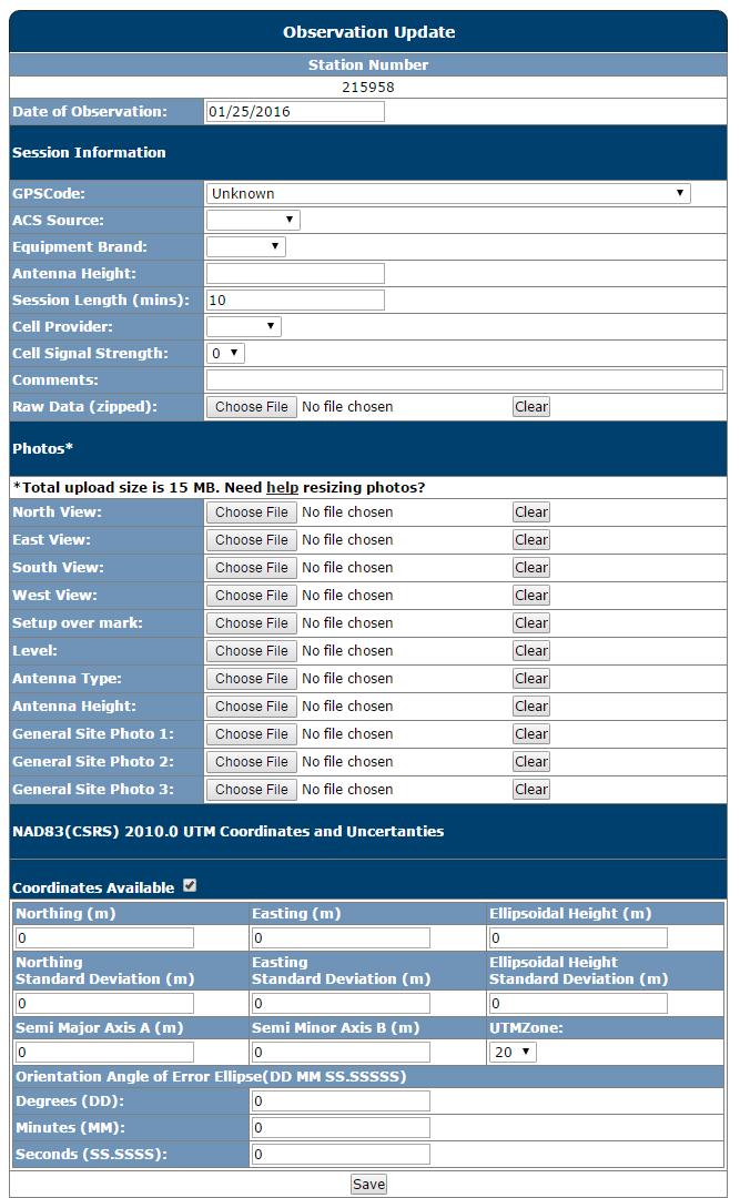
4 Observation Update - allows a user to submit new coordinates, photos, and various other information for a station. Using the correct settings, the uncertainty fields found at the bottom of the form (see Additional Illustrations) can be obtained from all systems (eg. Leica, Trimble, and TopCon). ACS source stands for Active Control System source and a dropdown list of options is provided for user convenience. What format should my raw data be in? The raw file should be converted to RINEX if possible and the file should be renamed as follows: Station#_ApAAA_YYMMDDSS_XXX Where: Station# is the unique station number assigned to the monument ApAAA is the antenna height and p represents the decimal point YY are the last two digits of the year of observations MM is the month of observations DD is the day of observations SS is the session number XXX are the initials of the observer For example: _2p000_130601_MAD.raw All manufacturers have utilities for converting their property data to RINEX. When will my data be integrated? Data submissions are integrated into the system on a semi-annual basis (spring, autumn). In order to have a coordinate updated to a publishable state, the following criteria must be met: At least two observers have submitted coordinates Each session is 10 minutes or more Data is logged at a 1s data rate Greater than 0.5 hour between all sessions At least 24 hours between any 2 sessions Less than 20 mm horizontal and 30 mm vertical discrepancy between all sessions 4
5 As data is submitted, the station status will progress as follows: Session Status 1 Provisional (unverified) 2 Pre-Published (once verified) 3 Published (twice verified) Only Published values should be referenced on a survey plan. What does each submission field require? Session Info Explanation GPS Code ACS Source Equipment Brand Session Length Cell Provider Cell Signal Strength Comments Raw Data (zipped) Photos North, East, South, West View See above Currently there are three sources of corrections who provide their services for a monthly fee. These include Can-net, Topnet, and Smartnet The manufacturer of the receiver used during the observation being submitted The length of time in minutes of the observation being submitted Eg. Bell, Rogers, Telus, Eastlink. Allows the next user to have an expectation about the available survey methods around a monument. Anything site specific which would be included in a site sketch. Eg. place name or intersection, below grade 0.1 m, under cap and collar. The raw observation file for the GNSS observation being submitted North View is a photo of the monument site that was taken firstly square to the road and secondly in the N,E,S,W directions. It is 5
6 suggested that the first photos be taken in the listed order in an effort to simplify data management and submission. Setup over mark Level Antenna Type Antenna Height General Site Photo 1,2,3 This is a close up photo of the monument cap with the fixed rod setup over the mark. It allows future users to verify the monument has not been disturbed since published and verifies correct setup during occupation. This is a close up photo of the level bubble during the observation being submitted. A photo verifying the antenna type used. A close up photo verifying the height of the rod for the observation being submitted. Photos that show additional information about the site for future users. This might include a building nearby or a civic address or a nearby road sign. Coordinates & Uncertainties Northing Easting Ellipsoidal Height Standard Deviations Semi Major Axis This is the NRTK Northing measured or in cases where cell coverage was not possible it is the post processed Northing. Submitted in metres. This is the NRTK Easting measured or in cases where cell coverage was not possible it is the post processed Easting. Submitted in metres. The height to be measured is ellipsoidal height. Enter its value here in metres. The standard deviations are a calculation the proprietor s (Trimble, Leica, etc.) software calculates and provide to the user. Contact your GNSS provider for more details. Enter this value in metres. The semi major axis is the larger of the two radii that describe an ellipse. During observation several positions are measured and averaged. An error ellipse is a statistical evaluation of all the 6
7 Semi Minor Axis UTM Zone Orientation Angle of Error Ellipse Related Technical Support Documents: - Technical Support 0002 NSACS Network - Technical Support 0007 NAD83 - Technical Support 0009 Field Operations Useful Links: Additional Illustrations: positions that were averaged. The proprietor s software calculates the semi major axis and provides it to the user. Contact your GNSS provider or manual for more details. Enter this value in metres. The semi minor axis is the smaller of the two radii that describe an ellipse. During observation several positions are measured and averaged. An error ellipse is a statistical evaluation of all the positions that were averaged. The proprietor s software calculates the semi minor axis and provides it to the user. Contact your GNSS provider or manual for more details. Enter this value in metres. UTM Zone refers to the UTM zone that was set in the software/controller during observation. Refers to the orientation of the major axis of the error ellipse. The semi major, semi minor, and orientation angle of the error ellipse together provide an evaluation of the accuracy of the position. This value is calculated by the proprietor. This is entered as degrees, minutes, seconds. 7
8 8
HORIZONTAL PROJECTION PARAMETERS: DANE COUNTY COORDINATES
 Recommended RTK GPS Configuration Parameters for the City of Madison, WI Base Station Compiled by: Dan Rodman RLS, City of Madison (608)266-6674 drodman@cityofmadison.com For base station information see
Geospatial Data Standards Considerations for the delivery of 2D and 3D spatial data February 2019
 Geospatial Data Standards Considerations for the delivery of 2D and 3D spatial data February 2019 Prepared by: GRCA Geomatics Version Date Summary of Changes Changes Made By: 1.00 March 16, 2018 Version
Height Modernization 2013 A New Canadian Vertical Datum
 Height Modernization 2013 A New Canadian Vertical Datum What is Height Modernization? The Height Reference System Modernization is a project at the Geodetic Survey Division (GSD) of Natural Resources Canada
Integrating GPS and Conventional Survey Observations Using GNU Gama Least Square Adjustment Program
 Integrating GPS and Conventional Survey Observations Using GNU Gama Least Square Adjustment Program The use of autonomous GPS positioning for geo-referencing certain legal surveys in BC has been permitted
Laying the foundation for a digital Nova Scotia
 IOP Conference Series: Earth and Environmental Science PAPER OPEN ACCESS Laying the foundation for a digital Nova Scotia To cite this article: J Bond 2016 IOP Conf. Ser.: Earth Environ. Sci. 34 012002
Town of Chino Valley. Survey Control Network Report. mgfneerhg mc N. Willow Creek Road Prescott AZ
 Town of Chino Valley Survey Control Network Report mgfneerhg mc. 2050 N. Willow Creek Road Prescott AZ 86301 928-771-2376 Page 1 of 70 Table of Contents Town of Chino Valley Survey Datum Outline A short
Meeting the ODOT Survey & Mapping Specifications
 Meeting the ODOT Survey & Mapping Specifications A Simple Solution Presented by Ray Foos, P.S, ODOT CADD & Mapping Services & Jon Keller, P.S., ODOT District 3 Phases of an ODOT Survey Project Research
TOWARDS ROBUST LOCALIZATION OF RTK-GPS TOPOGRAPHIC SURVEYS 23
 TOWARDS ROBUST LOCALIZATION OF RTK-GPS TOPOGRAPHIC SURVEYS Jerry W. Nave, North Carolina A&T University; Tarig A. Ali, American University of Sharjah Abstract Localization is performed to fit the observed
BUILDING AN ACCURATE GIS
 BUILDING AN ACCURATE GIS 2006 GIS in the Rockies Denver, Colorado September 13, 2006 William E. Linzey United States Department of Commerce National Oceanic and Atmospheric Administration National Geodetic
Using UNAVCO Real-Time CORS Data, a No-Cost Positioning Resource
 Using UNAVCO Real-Time CORS Data, a No-Cost Positioning Resource By: Mark Silver, ms@igage.com, +1-801-412-0011 Date: 19 August 2014 UNAVCO is a non-profit consortium of Universities that coordinates the
Shape of the Earth. Data Output by the Receiver
 It is quite common for confusion to arise about the process used during a hydrographic survey when GPS-derived water surface elevation is incorporated into the data as an RTK Tide correction. This article
GRAVITY SURVEY TEELS MARSH PROSPECT
 GRAVITY SURVEY over the TEELS MARSH PROSPECT MINERAL COUNTY, NV for Dajin Resources (US) Corp. March 2015 SUBMITTED BY Magee Geophysical Services LLC 465 Leventina Canyon Road Reno, Nevada 89523 USA TEL
Approaches to GNSS & Geodesy
 Approaches to GNSS & Geodesy Ray Hintz Univ. of Maine Ray.hintz@.maine.edu The biggest complaint about state plane coordinates The concept that scale and elevation factor need to be applied to the pythagoreum
Survey of the Bwlch of Craig Bron-banog
 Survey of the Bwlch of Craig Bron-banog 31 October 2014 The Team: John Barnard, Graham Jackson, and Myrddyn Phillips 1) Introduction Craig Bron-banog (Hill Number 3358, Section 30C, 1:50000 OS Map 116,
Import Digital Spatial Data (Shapefiles) into OneStop
 into OneStop") Import Digital Spatial Data (Shapefiles) into OneStop» Intended User: Pipeline Licence Applicants Overview To apply for a pipeline or pipeline installation licence, applicants must upload the proposed
Import Digital Spatial Data (Shapefiles) into OneStop» Intended User: Pipeline Licence Applicants Overview To apply for a pipeline or pipeline installation licence, applicants must upload the proposed
METHODOLOGY & TESTING PROCEDURE
 METHODOLOGY & TESTING PROCEDURE Bartlett & West is committed to using the MidStates VRS system going forward into 2016. We realize that having a state wide VRS will mean a savings of time on our projects
GPS Measurement Protocol
 GPS Measurement Protocol Purpose To determine the latitude, longitude, and elevation of your school and of all your GLOBE sites Overview The GPS receiver will be used to determine the latitude, longitude
Survey of Garreg-hir 15 May ) Introduction 2) Equipment used and Conditions for Survey 3) The Survey 3.1) Character of Hill
 Introduction 2) Equipment used and Conditions for Survey 3) The Survey 3.1) Character of Hill") Survey of Garreg-hir 15 May 2011 The Team: John Barnard, Graham Jackson and Myrddyn Phillips 1) Introduction Garreg-hir (Section 31A, OS 1:50000 Map 136, Grid Ref. SN998977) is listed as a marginal Marilyn
Survey of Garreg-hir 15 May 2011 The Team: John Barnard, Graham Jackson and Myrddyn Phillips 1) Introduction Garreg-hir (Section 31A, OS 1:50000 Map 136, Grid Ref. SN998977) is listed as a marginal Marilyn
An Assessment of the Accuracy of PPP in Remote Areas in Oman
 An Assessment of the Accuracy of PPP in Remote Areas in Oman Rashid AL ALAWI, Sultanate of Oman and Audrey MARTIN, Ireland Keywords: GNSS, PPP, Oman Survey Infrastructure SUMMARY Traditionally, high accuracy
MODERNIZATION OF THE MUNICIPAL MAPPING USING HIGH END GNSS SYSTEM AND GIS SOFTWARE
 MODERNIZATION OF THE MUNICIPAL MAPPING USING HIGH END GNSS SYSTEM AND GIS SOFTWARE Mr. R. A. R. Khan Assistant Engineer, Sewerage Utility Management Centre (SUMC) Municipal Corporation Of Greater Mumbai
GPS and Mean Sea Level in ESRI ArcPad
 Summary In order to record elevation values as accurately as possible with, it is necessary to understand how ArcPad records elevation. Rather than storing elevation values relative to Mean Sea Level (MSL),
CONTROL MONUMENT REPORT
 CONTROL MONUMENT REPORT This document was prepared by Altus Geomatics for use by City of Yorkton staff and contractors working in and for the City of Yorkton. This document is meant to inform readers about
Fusion of Geodesy and GIS at NOAA s National Geodetic Survey
 Fusion of Geodesy and GIS at NOAA s National Geodetic Survey Esri Survey Summit July 6-9, 2013 San Diego, CA Michael Dennis, RLS, PE michael.dennis@noaa.gov The Plan Background NGS Data Explorer New Datasheet
Low Distortion Projections Part 2 Ground versus Grid
 Blue Marble Geographic Calculator provides an incredible variety of tools for working with an infinite combination of datums and projections. Shown here, I ve entered the parameters for a Low Distortion
The Next Generation GIS/LIS A Surveys Information System Integrated within a GIS
 The Next Generation GIS/LIS A Surveys Information System Integrated within a GIS Michael F. WEIR, USA Key words: Linking, Snapping, GIS, Measurements, Measurement Data, GIS Features, Spatial Quality. SUMMARY
This Land Surveying course has been developed by Failure & Damage Analysis, Inc.
 This Land Surveying course has been developed by Failure & Damage Analysis, Inc. www.discountpdh.com DEPARTMENT OF THE ARMY U.S. Army Corps of Engineers CECW-EP Washington, DC 20314-1000 ETL 1110-1-183
Final Report. Nova Scotia Coordinate Referencing System (NSCRS) Future Policy Strategy. November 17, 2011
 Future Policy Strategy. November 17, 2011") Final Report Nova Scotia Coordinate Referencing System (NSCRS) Future Policy Strategy November 17, 2011 Submitted to: Service Nova Scotia and Municipal Relations Geographic Information Services 9 South,
Final Report Nova Scotia Coordinate Referencing System (NSCRS) Future Policy Strategy November 17, 2011 Submitted to: Service Nova Scotia and Municipal Relations Geographic Information Services 9 South,
Principles of the Global Positioning System Lecture 23
 12.540 Principles of the Global Positioning System Lecture 23 Prof. Thomas Herring 05/12/03 12.540 Lec 23 1 OVERVIEW Run through HW 03. Final lecture: Application area and GPS results Analysis of contemporary
12/26/2012. Geographic Information Systems * * * * GIS (... yrezaei
 ( - Geographic Information Systems ( ( 1 2 3 Information System Data base DB IS IS DB (Knowledge ( ( (System (Information System - (Georefrence Analysis Data + Knowledge ======== Information 4 5 ( < 10%
Import Digital Spatial Data into OneStop
 Import Digital Spatial Data into OneStop» Intended User: Pipeline Licence or Amendments Applicants Overview To apply for a pipeline or pipeline installation licence, applicants must upload the proposed
2. GETTING STARTED WITH GIS
 2. GETTING STARTED WITH GIS What are geographic information systems and what are they used for? ArcGIS: ArcMap, ArcCatalog and ArcToolbox Vector data vs. raster data vs. attribute tables Polygons, polylines,
4 Survey Datums. 4.1 Horizontal Datum Policy SURVEY DATUMS SEPTEMBER 2006
 4 Survey Datums Today s multi-organizational Project Development efforts require the use of common, accurate horizontal and vertical survey datums and consistent, precise control-survey procedures to ensure
Survey of Thack Moor
 Survey of Thack Moor 22 August 2012 The Team: John Barnard, Graham Jackson and Myrddyn Phillips 03 March 2013 The Team: John Barnard, Graham Jackson, Myrddyn Phillips and Bob Smith (Grough) 1) Introduction
Carlson CR Robotic/Reflectorless Total Station
 0 West Second Street Suite 00 Maysville, KY 4056 www.carlsonsw.com Phone: 606-564-508 Fax: 606-564-64 Type starts around here Carlson CR Robotic/Reflectorless Total Station Calibration Overview Congratulations
Geographic Information Systems class # 1 February 19, Coordinate reference systems in GIS: geodetic coordinates
 Geographic Information Systems class # 1 February 19, 2013 Coordinate reference systems in GIS: geodetic coordinates Manuel Campagnolo ISA Manuel Campagnolo (ISA) GIS/SIG 2012 2013 February 19, 2013 1
Building a Local Transverse Mercator (LTM) Grid aligned with MGA94 for use in GNSS and GIS Richard Stanaway
 Grid aligned with MGA94 for use in GNSS and GIS Richard Stanaway") Building a Local Transverse Mercator (LTM) Grid aligned with MGA94 for use in GNSS and GIS Richard Stanaway Quickclose What is an LTM? An LTM (Local Transverse Mercator) is a working Plane Grid Used for
Building a Local Transverse Mercator (LTM) Grid aligned with MGA94 for use in GNSS and GIS Richard Stanaway Quickclose What is an LTM? An LTM (Local Transverse Mercator) is a working Plane Grid Used for
A Deformation Model to support a Next Generation Australian Geodetic Datum
 A Deformation Model to support a Next Generation Australian Geodetic Datum Richard Stanaway, Surveying and Geospatial Engineering School of Civil and Environmental Engineering multi-gnss + augmentation
Frames for the Future New Datum Definitions for Modernization of the U.S. National Spatial Reference System
 Figure 10. Horizontal position differences (in meters) between NAD 83 and ITRF 08 at time 2022.00 (January 1, 2022). Positional differences are shown for the North American and Pacific tectonic plates.
A new geoid model for Bhutan. Machiel Bos Rui Fernandes
 A new geoid model for Bhutan Machiel Bos (machiel@segal.ubi.pt) Rui Fernandes (rui@segal.ubi.pt) June 2015 1 Definition of heights June 2015 2 Purpose of a geoid model Orthometric heights are the official
Warkworth Observatory Local Tie Survey
 2015 - Warkworth Observatory Local Tie Survey Complied by Land Information New Zealand Record A1387321 Contents Executive Summary... 5 Acknowledgements... 5 1. Introduction... 1 2. Site Description...
Simple Harmonic Motion
 Introduction Simple Harmonic Motion The simple harmonic oscillator (a mass oscillating on a spring) is the most important system in physics. There are several reasons behind this remarkable claim: Any
Applied Cartography and Introduction to GIS GEOG 2017 EL. Lecture-1 Chapters 1 and 2
 Applied Cartography and Introduction to GIS GEOG 2017 EL Lecture-1 Chapters 1 and 2 What is GIS? A Geographic Information System (GIS) is a computer system for capturing, storing, querying, analyzing and
Mass Asset Additions. Overview. Effective mm/dd/yy Page 1 of 47 Rev 1. Copyright Oracle, All rights reserved.
 Overview Effective mm/dd/yy Page 1 of 47 Rev 1 System References None Distribution Oracle Assets Job Title * Ownership The Job Title [list@yourcompany.com?subject=eduxxxxx] is responsible for ensuring
A Comparison of Different Methods Using GNSS RTK to Establish Control Points in Cadastral Surveying
 A Comparison of Different Methods Using GNSS RTK to Establish Control Points in Cadastral Surveying Patric Jansson Liselotte Lundgren Report Stockholm 2018 TRITA-ABE-RPT-192 KTH, Real Estate and Construction
Mountain View Community Shuttle Monthly Operations Report
 Mountain View Community Shuttle Monthly Operations Report December 6, 2018 Contents Passengers per Day, Table...- 3 - Passengers per Day, Chart...- 3 - Ridership Year-To-Date...- 4 - Average Daily Ridership
10/13/2011. Introduction. Introduction to GPS and GIS Workshop. Schedule. What We Will Cover
 Introduction Introduction to GPS and GIS Workshop Institute for Social and Environmental Research Nepal October 13 October 15, 2011 Alex Zvoleff azvoleff@mail.sdsu.edu http://rohan.sdsu.edu/~zvoleff Instructor:
Intro to GIS Fall 2010 Georeferencing & Map Projections
 Intro to GIS Fall 2010 Georeferencing & Map Projections SHAPE OF THE EARTH Earth's Shape Geoid: shape of earth minus topographic features (irregular due to local variations in gravity) Ellipsoid: elongated
This week s topics. Week 6. FE 257. GIS and Forest Engineering Applications. Week 6
 FE 257. GIS and Forest Engineering Applications Week 6 Week 6 Last week Chapter 8 Combining and splitting landscape features and merging GIS databases Chapter 11 Overlay processes Questions? Next week
International Journal of Computer Science and Telecommunications [Volume 3, Issue 7, July 2012] 109. Levelling with GPS. Dr. Nagi Zomrawi Mohammed
![International Journal of Computer Science and Telecommunications [Volume 3, Issue 7, July 2012] 109. Levelling with GPS. Dr. Nagi Zomrawi Mohammed](/thumbs/94/120062601.jpg "International Journal of Computer Science and Telecommunications [Volume 3, Issue 7, July 2012] 109. Levelling with GPS. Dr. Nagi Zomrawi Mohammed") International Journal of Computer Science and Telecommunications [Volume 3, Issue 7, July 2012] 109 ling with ISSN 2047-3338 Dr. Nagi Zomrawi Mohammed Associate Professor, College of Engineering, Sudan
International Journal of Computer Science and Telecommunications [Volume 3, Issue 7, July 2012] 109 ling with ISSN 2047-3338 Dr. Nagi Zomrawi Mohammed Associate Professor, College of Engineering, Sudan
BUILDING AN ASSET MANAGEMENT GEODATABASE FOR RANCHING. Matt Crawford, GISP
 BUILDING AN ASSET MANAGEMENT GEODATABASE FOR RANCHING Matt Crawford, GISP Introduction East Foundation Formed in 2007 Mission Research Education Outreach Properties Six ranches ~ 215,000 acres San Antonio
Part 5: Total stations
 Provläsningsexemplar / Preview INTERNATIONAL STANDARD ISO 17123-5 Third edition 2018-02 Optics and optical instruments Field procedures for testing geodetic and surveying instruments Part 5: Total stations
Geog Lecture 29 Mapping and GIS Continued
 Geog 1000 - Lecture 29 Mapping and GIS Continued http://scholar.ulethbridge.ca/chasmer/classes/ Today s Lecture (Pgs 13-25, 28-29) 1. Hand back Assignment 3 2. Review of Dr. Peddle s lecture last week
Global Navigation Satellite Systems
 Global Navigation Satellite Systems GPS GLONASS Galileo BeiDou I I (COMPASS)? How Does a GNSS Work? Based on principle of triangulation Also called satellite ranging Signal travels at constant speed (3.0x10
Monthly Magnetic Bulletin
 BRITISH GEOLOGICAL SURVEY Fort McMurray Observatory Monthly Magnetic Bulletin February 2016 16/02/FM Fort McMurray FORT McMURRAY OBSERVATORY MAGNETIC DATA 1. Introduction The British Geological Survey
The Gauss Conform Coordinate
 Surveying The South African Coordinate Reference System (Part 2) by Aslam Parker, Chief Directorate: National Geo-spatial Information Part 1 of this article (see PositionIT Nov/Dec 2011) focused on the
Mapping coordinate systems
 Mapping coordinate systems 1. The Earth's Graticule Latitude and Longitude The graticule is the imaginary grid of lines running east-west (lines of latitude = parallels) and north-south lines of longitude
Monthly Magnetic Bulletin
 BRITISH GEOLOGICAL SURVEY Fort McMurray Observatory Monthly Magnetic Bulletin March 2017 17/03/FM Fort McMurray FORT McMURRAY OBSERVATORY MAGNETIC DATA 1. Introduction The British Geological Survey (BGS)
Sales Analysis User Manual
 Sales Analysis User Manual Confidential Information This document contains proprietary and valuable, confidential trade secret information of APPX Software, Inc., Richmond, Virginia Notice of Authorship
SECTION 4 PARCEL IDENTIFIERS 4.1 LONGITUDE AND LATITUDE
 SECTION 4 PARCEL IDENTIFIERS 4.1 LONGITUDE AND LATITUDE Most maps must be drawn in such a way that points and areas can be located accurately on the earth's surface and described objectively. A uniform
enny Mills chool of Civil ngineering & eosciences ewcastle University
 Future of Surveying: Educating the future geospatial expert A Newcastle University perspective enny Mills chool of Civil ngineering & eosciences ewcastle University Future of surveying: Do we still need
MobileMapper 6. White Paper. MobileMapper 6 vs. Juno SC In Real World Conditions. Sub-Meter, Post-Processed Accuracy for less than 1,500 USD
 MobileMapper 6 White Paper MobileMapper 6 vs. Juno SC In Real World Conditions Sub-Meter, Post-Processed Accuracy for less than 1,500 USD Table of Contents Introduction...1 Testing Methodology...2 Test
Historic Cultural Properties Inventory (HCPI) Base Form (FORM 1)
 Base Form (FORM 1)") Historic Cultural Properties Inventory (HCPI) Base Form (FORM 1) Historic Preservation Division, New Mexico Office of Cultural Affairs For HPD Office use only: HCPI No. District No. NRHP: SRCP: Criteria:
Historic Cultural Properties Inventory (HCPI) Base Form (FORM 1) Historic Preservation Division, New Mexico Office of Cultural Affairs For HPD Office use only: HCPI No. District No. NRHP: SRCP: Criteria:
DMS-UAV Accuracy Assessment: AP20 with Nikon D800E
 DMS-UAV Accuracy Assessment: AP20 with Nikon D800E Joe Hutton, Greg Lipa, James Lutes, Omer Mian Applanix, William Chan - GeoPixel Air Introduction The Direct Mapping Solution for Unmanned Aerial Vehicles
Georeferencing. Where on earth are we? Critical for importing and combining layers for mapping
 Georeferencing Where on earth are we? Critical for importing and combining layers for mapping 1. The Geoid Earth is not a perfect sphere, it is ellipsoidal.. earth is the 'Geoid'. The difference between
Changes are coming NGS NSRS Modernization Are you Ready?
 Changes are coming NGS 2022 - NSRS Modernization Are you Ready? Pam Fromhertz Rocky Mountain Regional Advisor Pamela.Fromhertz@noaa.gov 240-988-6363 John Hunter CO State Geomatics Coordinator DRCOG March
VT STATEWIDE PROPERTY PARCEL MAPPING PROJECT & PROGRAM
 VT STATEWIDE PROPERTY PARCEL MAPPING PROJECT & PROGRAM BUILDING A FOUNDATIONAL MAPPING DATA LAYER Leslie Pelch, VCGI April 2017 WHAT ARE THE STATEWIDE PROPERTY PARCEL MAPPING PROJECT & PROGRAM? A project
Mapping Utilities with Mobile GIS Applications
 Mapping Utilities with Mobile GIS Applications Kristy M. Capobianco Reynolds, Smith and Hills, Inc. GIS Analyst Kristy.Capobianco@rsandh.com (904) 256-2251 2007 ESRI Southeast User Group Conference May
Georeferencing. Place names Postal addresses Postal codes Coordinate systems (lat/long, UTM, etc.)
") Georeferencing Georeferencing Used to describe the act of assigning locations to data or information Certain requirements include that they are: unique, have shared meaning, and are persistent through
Georeferencing Georeferencing Used to describe the act of assigning locations to data or information Certain requirements include that they are: unique, have shared meaning, and are persistent through
Projections & GIS Data Collection: An Overview
 Projections & GIS Data Collection: An Overview Projections Primary data capture Secondary data capture Data transfer Capturing attribute data Managing a data capture project Geodesy Basics for Geospatial
PHY 123 Lab 9 Simple Harmonic Motion
 PHY 123 Lab 9 Simple Harmonic Motion (updated 11/17/16) The purpose of this lab is to study simple harmonic motion of a system consisting of a mass attached to a spring. You will establish the relationship
MLLW and the NAD83 Ellipsoid: An Investigation of Local Offsets and Trends Using PPK and Gauge Derived Water Surfaces.
 MLLW and the NAD83 Ellipsoid: An Investigation of Local Offsets and Trends Using PPK and Gauge Derived Water Surfaces. Abstract: Authors Doug Lockhart, Fugro Pelagos, Inc. Andy Orthmann, Fugro Pelagos,
LED Lighting Facts: Manufacturer Guide
 LED Lighting Facts: Manufacturer Guide 2018 1 P a g e L E D L i g h t i n g F a c t s : M a n u f a c t u r e r G u i d e TABLE OF CONTENTS Section 1) Accessing your account and managing your products...
PHYS208 RECITATIONS PROBLEMS: Week 2. Electric fields
 Electric fields Prob.#1 Prob.#2 Prob.#3 Prob.#4 Prob.#5 Total Your Name: Your UIN: Your section# These are the problems that you and a team of other 2-3 students will be asked to solve during the recitation
What is Geodesy? Types of Geodesy terrestrial or classical geodesy space geodesy theoretical geodesy
 What is Geodesy? Geodesy is the study of: The size, shape and motion of the earth The measurement of the position and motion of points on the earth's surface, and The study of the earth's gravity field
A Strategic Plan for Geodesy in Sweden. Mikael Lilje Lars E. Engberg Geodesy Department Lantmäteriet Sweden
 A Strategic Plan for Geodesy in Sweden Mikael Lilje Lars E. Engberg Geodesy Department Lantmäteriet Sweden Our vision is to be able to meet Swedish society s needs for a homogeneous, sustainable geodetic
Lecture 4. Coordinate Systems & Projections
 Lecture 4 Coordinate Systems & Projections Outline Geodesy Geoids Ellipsoids Geographic Coordinate Systems Magnetic North vs. True North Datums Projections Applying Coordinate Systems and Projections Why
The Canadian Height Modernization Initiative. Information for British Columbia Stakeholders / Clients
 The Canadian Height Modernization Initiative Information for British Columbia Stakeholders / Clients Introduction A modern society requires the ability to measure elevations relative to mean sea level
Simple Harmonic Motion
 Physics Topics Simple Harmonic Motion If necessary, review the following topics and relevant textbook sections from Serway / Jewett Physics for Scientists and Engineers, 9th Ed. Hooke s Law (Serway, Sec.
Coordinate systems, measured surveys for BIM, total station for BIM, as-built surveys, setting-out
 Coordinate systems, measured surveys for BIM, total station for BIM, as-built surveys, setting-out What is a BIM What does a BIM do Why use a BIM BIM Software BIM and the Surveyor How do they relate to
CE 316 GEOMATICS COURSE NOTES DR. MOIR D HAUG, C.L.S., P. ENG. JANUARY 2012
 CE 316 GEOMATICS COURSE NOTES DR. MOIR D HAUG, C.L.S., P. ENG. JANUARY 2012 0 COURSE INFORMATION Dr Moir D Haug, P. Eng University Office 2B25 Engineering 966 5355 moir.haug@usask.ca MDH Engineered Solutions
Semi-Dynamic Datum of Indonesia
 Technical Seminar Reference Frame in Practice, Semi-Dynamic Datum of Indonesia H.Z. Abidin, A.B. Wijanarto, S.T. Wibowo, Susilo, J. Efendi Geospatial Information Agency, Indonesia (BIG) Sponsors: Page
Week 02. Assist. Prof. Dr. Himmet KARAMAN
 Week 02 Assist. Prof. Dr. Himmet KARAMAN Contents Satellite Orbits Ephemerides GPS Review Accuracy & Usage Limitation Reference Systems GPS Services GPS Segments Satellite Positioning 2 Satellite Orbits
Evaluation of GPS in Orthometric Heights Determination in Khartoum State (Sudan)
") Evaluation of GPS in Orthometric Heights Determination in Khartoum State (Sudan) Dr. Nagi Zomrawi Mohammed 1, Dr. Abd Elrahim Elgizouli Mohammed 2 and Engineer Osman Bakry 3 1 Sudan University of Science
Evaluation of GPS in Orthometric Heights Determination in Khartoum State (Sudan) Dr. Nagi Zomrawi Mohammed 1, Dr. Abd Elrahim Elgizouli Mohammed 2 and Engineer Osman Bakry 3 1 Sudan University of Science
Exit Programme Outcomes (Qualification Outcomes): Upon completion of the Bachelor of Geomatics programme, graduates should be able to:
: Upon completion of the Bachelor of Geomatics programme, graduates should be able to:") BACHELOR OF GEOMATICS (NQF - Level 7) Programme Aims/Purpose: The Bachelor of Geomatics programme is purposefully designed prepare students for a career as professional surveyor, with high level knowledge
BACHELOR OF GEOMATICS (NQF - Level 7) Programme Aims/Purpose: The Bachelor of Geomatics programme is purposefully designed prepare students for a career as professional surveyor, with high level knowledge
Relative Positional Precision Explained in Everyday Language. Measurement vs. Enumeration. ALTA / ACSM Standards and Kentucky Standards of Practice
 Relative Positional Precision Explained in Everyday Language Todd W. Horton, PE, PLS February 015 Definitions Surveying That discipline which encompasses all methods for measuring, processing, and disseminating
QuestUAV DATAhawk PPK Accuracy Assessment and Validation
 QuestUAV DATAhawk PPK Accuracy Assessment and Validation Accuracy of 3.0cm(X), 3.3cm(Y), 3.9cm(Z) Nigel King 1, Kerstin Traut 2, Cameron Weeks 3, Chris Mills 4, Phil Mills 5, Ruairi Hardman 6, Stuart King
Preparation of Database for Urban Development
 Preparation of Database for Urban Development By PunyaP OLI, 1. Chairman, ERMC (P) Ltd., Kathmandu, Nepal. Email: punyaoli@ermcnepal.com 2. Coordinator, Himalayan College of Geomatic Engineering and Land
MAPPS 2012 Geospatial Products and Services Excellence Awards Awards Entry Form
 MAPPS 2012 Geospatial Products and Services Excellence Awards 2012 Awards Entry Form Please include a copy of this document with the project/product submission Entry Information Submission Number: 1741558
ch02.pdf chap2.pdf chap02.pdf
 Introduction to Geographic Information Systems 8th Edition Karl Solutions Manual Full Download: http://testbanklive.com/download/introduction-to-geographic-information-systems-8th-edition-karl-solutions-manu
AGGREGATE RESOURCES OF ONTARIO (ARO) METADATA
 METADATA") AGGREGATE RESOURCES OF ONTARIO (ARO) METADATA GENERAL INFORMATION Official Name of the Data Set or Information Holding: Aggregate Resources of Ontario Acronyms are Used to Identify the Data Set or Information
AGGREGATE RESOURCES OF ONTARIO (ARO) METADATA GENERAL INFORMATION Official Name of the Data Set or Information Holding: Aggregate Resources of Ontario Acronyms are Used to Identify the Data Set or Information
Centralized Forecasting Registration and Communication Requirements for Distribution Connected Variable Generators. IESO Training
 Centralized Forecasting Registration and Communication Requirements for Distribution Connected Variable Generators IESO Training May 2017 Centralized Forecasting - Registration and Communication Requirements
COUNTRY REPORT ON CARTOGRAPHIC ACTIVITIES IN SINGAPORE ( ) Submitted by Singapore **
 Submitted by Singapore **") UNITED NATIONS E/CONF.97/5/CRP. 9 ECONOMIC AND SOCIAL COUNCIL Seventeenth United Nations Regional Cartographic Conference for Asia and the Pacific Bangkok, 18-22 September 2006 Item 6 (b) of the provisional
UNITED NATIONS E/CONF.97/5/CRP. 9 ECONOMIC AND SOCIAL COUNCIL Seventeenth United Nations Regional Cartographic Conference for Asia and the Pacific Bangkok, 18-22 September 2006 Item 6 (b) of the provisional
Annual TTFO Meeting April 10, 2018 Michael J. Wittman, P.S. Chief Surveyor / GIS Coordinator
 Annual TTFO Meeting April 10, 2018 Michael J. Wittman, P.S. Chief Surveyor / GIS Coordinator Text Book Definition: Layman Terms: An organized collection of hardware, software and geographic data designed
PROJECT FOR THE PRODUCTION OF 1/1000 SCALE BASE MAPS FROM COLOUR IMAGES USING DIGITAL CAMERAS IN BURSA METROPOLITAN AREA (BMA) IN TURKEY
 IN TURKEY") PROJECT FOR THE PRODUCTION OF 1/1000 SCALE BASE MAPS FROM COLOUR IMAGES USING DIGITAL CAMERAS IN BURSA METROPOLITAN AREA (BMA) IN TURKEY Şenol KUŞCU, M.Sait AYIK, Eray CAN, Hasan Yasar ARKAYIN, Turkey
PROJECT FOR THE PRODUCTION OF 1/1000 SCALE BASE MAPS FROM COLOUR IMAGES USING DIGITAL CAMERAS IN BURSA METROPOLITAN AREA (BMA) IN TURKEY Şenol KUŞCU, M.Sait AYIK, Eray CAN, Hasan Yasar ARKAYIN, Turkey
Enabling Success in Enterprise Asset Management: Case Study for Developing and Integrating GIS with CMMS for a Large WWTP
 Enabling Success in Enterprise Asset Management: Case Study for Developing and Integrating GIS with CMMS for a Large WWTP Allison Blake, P.E. 1*, Matthew Jalbert, P.E. 2, Julia J. Hunt, P.E. 2, Mazen Kawasmi,
Survey of Stapleton Hill East
 31 January 2018 Survey of Stapleton Hill East The Team: John Barnard, Graham Jackson and Richard Mclellan 1) Introduction Stapleton Hill East (Hill Number 17017, Section 38B, OS 1:50000 Map 137, 148, 149,
NATRF 2022 AND LDP OCTOBER 11, 2017
 NATRF 2022 AND LDP OCTOBER 11, 2017 MODERNIZATION OF THE NSRS Why? Leaving passive control marks behind and relying solely on the CORS network for 3D positions: Older methodology relies on terrestrial
Supporting Infrastructure for the Development of Location-based Services in Hong Kong
 Supporting Infrastructure for the Development of Location-based Services in Hong Kong NG Kwok-wai, Paul Assistant Director/Survey and Mapping Lands Department 20 October 2015 Contents Positioning Infrastructure
GISC3325 Spring 2011 Final Exam
 GISC3325 Spring 2011 Final Exam Name: Carefully read each question. Identify the important elements and the question being asked. Show your work for partial credit. No credit for undocumented wrong answers.
Raymond Bure. ASPNG 50 th Survey Congress 2016
 Raymond Bure ASPNG 50 th Survey Congress 2016 Introduction Survey Mark Infrastructure PNG94: Static to Semi-dynamic system Standard Data Infrastructure Striking up a conversation Are the current plans