Mapping Utilities with Mobile GIS Applications
|
|
|
- Angel Allen
- 5 years ago
- Views:
Transcription
1 Mapping Utilities with Mobile GIS Applications Kristy M. Capobianco Reynolds, Smith and Hills, Inc. GIS Analyst (904) ESRI Southeast User Group Conference May 5, 2007
2 JEA JEA is the 8 th Largest Utility Company in the Country JEA Services 360,000 Electric Customers 240,000 Water Customers 184,000 Sewer Customers JEA Electric Owns 3 Generating Plants and Shares Ownership of 2 Others Total Generating Capacity Is 2,361 MW of Power JEA Water Uses Groundwater from 150 Wells. JEA Has 44 Water Treatment Plants and 3,480 Miles of Water Piping JEA Sewer Has 2,500 Miles of Collection Piping and 6 Waste Water Treatment Plants
3 Project Background Engineering, Construction and Services (EC&S) 50 Million Dollar a Year Program Manages Projects from Conception to Design to Permitting to Construction to Close Out
4 EC&S Problems Projects Are Established with Sometimes Millions of Dollars Allotted to Them Close Out of Projects/As-Builts Required Months of Time Slow Close Outs Left Large Sums of Money Encumbered Money That Should Be Used on Other Projects Accuracy of the As-Builts Are Sometimes, at the Least, Questionable Information Needed for JEA Crews with Leakage Problems
5 Solution Take the As-Built Responsibilities from the Contractor Use GPS/GIS Technology to Increase Accuracy Continue with AutoCAD Drawings for Operations Personnel Include GIS Maps for Data Evaluation and Hydraulic Analysis Allows for a QA/QC Evaluation During Construction
6 New JEA Specifications Standard Requirements for JEA Contractors All contracts now include requirements which allow for more accurate As-Builts at a faster pace Stand pipe at every 100 feet allows a great degree of information for future maintenance crews Shooting every fitting and valve provides exact information immediately during emergencies regarding which valves must be closed Benchmark every 500 feet ensures the GPS Technician need only set up once for many points required Allows immediate QA/QC on the final product
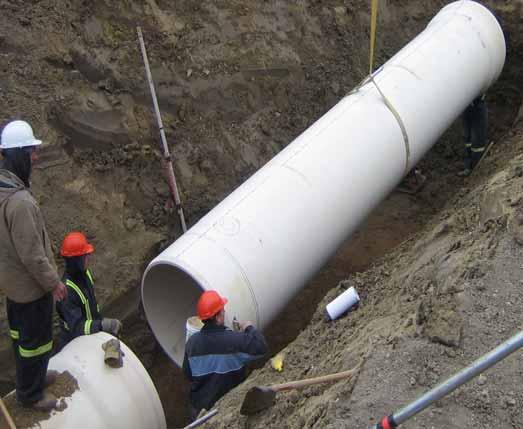
7 Pipe Construction
8 Data Collection Methodology GPS Collection Standards The GPS data collector collects with a Trimble GeoXH handheld unit coupled with a Zephyr antenna to acquire the highest horizontal accuracy possible (sub- meter in field or better if H-Star H lock is acquired). The JEA As-Builts Data Dictionary shall be used for all projects undertaken. This Data Dictionary contains all the features, attributes and standards of data needed for the project. Mission planning must be conducted daily by the GPS data collector before heading into the field to determine the optimal time(s) for data collection. Some items that must be considered are PDOP and number of satellites available.
9 Data Collection Methodology Point Features (valves, fittings, stand pipes, benchmarks) All data will be collected using TerraSync software. Point features must have a minimum of 30 positions collected at a logging interval of 1 second. Line Features (water, sewer, reclaim main) Line features shall be collected using the averaged vertices method. This method allows several positions to be collected at each vertex (stand pipe), then averages these positions together to calculate one vertex position.
10 Differential Correction Differential correction (post-processing) must be conducted on each file that is downloaded from the GPS receiver. This process will output a summary of estimated accuracies for all corrected positions. If features fall outside the acceptable range of accuracy (3-feet) they must be recollected by the GPS data collector.


11 Differential Correction After post-processing all data are exported as ESRI shapefiles with the same coordinate system that the data was collected (US State Plane 1983, Florida East, NAD83 Feet). The following attributes are generated on creation: Time and Date Recorded, Horizontal Precision, and Position (Northing and Easting).

12 Shapefile Creation and Editing

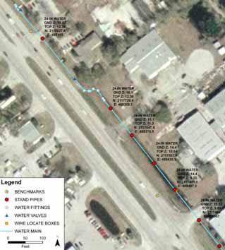
13 SAMPLE GIS MAPS

14 Data Storage File Geodatabase Easily and logically stores GIS data. Each draft has its own feature dataset that is populated with the newly created data. Feature-Linked Annotation If an attribute of the GIS feature class is changed/deleted the annotation will automatically update with changes to the feature class.
 along with the annotation layer.")
15 Conversion to CAD Format ArcInfo License DWG 2004 format (JEA Standard). Select feature (valve, fitting, etc.) along with the annotation layer. JEA STANDARD

16 Conversion to CAD Format

17 Creation of As-Built Plans
18 Next Steps: 3D Profile View
19 Benefits of GPS Data Collection Savings Over Contractor s s Costs Lake Forest Contractor at $105,000 JEA Collection & As Built Costs at $71,336 Savings on One Job of $33,664 or 32% Improvement of the Accuracy of the Drawings 85% of Data Is Within 15 cm or Less Than 1 Foot Closeout Contracts Sooner Releasing Funding Accurate QC & QA as the Project Is Installed Increase the Speed of the Process with GPS Equipment vs. Old Survey Methods Indirect Costs Savings Less Administrative Costs Due to Long Closeout Periods Import Directly into GIS Database GIS Shapefiles for the Records Department AutoCAD for Design Engineers
20 Questions? Contact Information: Kristy M. Capobianco Reynolds, Smith and Hills, Inc. GIS Analyst (904)
Empowering water/wastewater network management with GIS
 Empowering water/wastewater network management with GIS Ioannis Kavouras_GIS Manager Surveying Engineer, MSc, MBA The Company responsible for fresh water distribution & sanitation serving 1.500.000 citizens
BUILDING AN ASSET MANAGEMENT GEODATABASE FOR RANCHING. Matt Crawford, GISP
 BUILDING AN ASSET MANAGEMENT GEODATABASE FOR RANCHING Matt Crawford, GISP Introduction East Foundation Formed in 2007 Mission Research Education Outreach Properties Six ranches ~ 215,000 acres San Antonio
Enabling Success in Enterprise Asset Management: Case Study for Developing and Integrating GIS with CMMS for a Large WWTP
 Enabling Success in Enterprise Asset Management: Case Study for Developing and Integrating GIS with CMMS for a Large WWTP Allison Blake, P.E. 1*, Matthew Jalbert, P.E. 2, Julia J. Hunt, P.E. 2, Mazen Kawasmi,
GIS TECHNICIAN I GIS TECHNICIAN II
 GIS TECHNICIAN I GIS TECHNICIAN II CITY OF ROSEVILLE DEFINITION To perform a variety of technical office and field work duties related to the creation and maintenance of maps, tables, graphs and other
MODERNIZATION OF THE MUNICIPAL MAPPING USING HIGH END GNSS SYSTEM AND GIS SOFTWARE
 MODERNIZATION OF THE MUNICIPAL MAPPING USING HIGH END GNSS SYSTEM AND GIS SOFTWARE Mr. R. A. R. Khan Assistant Engineer, Sewerage Utility Management Centre (SUMC) Municipal Corporation Of Greater Mumbai
GeoSpatial Water Distribution, Sanitary Sewer and Stormwater Network Modeling
 2009 Bentley Systems, Incorporated GeoSpatial Water Distribution, Sanitary Sewer and Stormwater Network Modeling Angela Battisti, Gary Griffiths Bentley Systems Inc Presenter Profile Angela Battisti, CE,
GIS-T 2010 Building a Successful Geospatial Data Sharing Framework: A Ohio DOT Success Story
 GIS-T 2010 Building a Successful Geospatial Data Sharing Framework: A Ohio DOT Success Story ODOT District 2 GIS John Puente District 1 GIS Coordinator\ Planning Administrator 2 Interoperability 3 District
Chapter 6: Conclusion
 Chapter 6: Conclusion As stated in Chapter 1, the aim of this study is to determine to what extent GIS software can be implemented in order to manage, analyze and visually illustrate an IT-network between
This paper outlines the steps we took to process the repository file into a Geodatabase Utility Data Model for Bloomfield Township s analysis.
 Title of Paper Importing CAD Drawings into a Utility Data Model Authors Names Kevin G. Broecker & James R. Miller Abstract This presentation covers the process needed to integrate data from a CAD drawing
GIS Workshop Data Collection Techniques
 GIS Workshop Data Collection Techniques NOFNEC Conference 2016 Presented by: Matawa First Nations Management Jennifer Duncan and Charlene Wagenaar, Geomatics Technicians, Four Rivers Department QA #: FRG
Steve Pietersen Office Telephone No
 Steve Pietersen Steve.Pieterson@durban.gov.za Office Telephone No. 031 311 8655 Overview Why geography matters The power of GIS EWS GIS water stats EWS GIS sanitation stats How to build a GIS system EWS
CLICK HERE TO KNOW MORE
 CLICK HERE TO KNOW MORE Integrating GIS data for Water Distribution Modeling Case Study: General Directorate of Water Eng. Atif Karrani - GIS Manager karrani@sewa.gov.ae Agenda Introduction Enterprise
Lesson: Don t Wait For the Storm
 Lesson: Don t Wait For the Storm Developing a GIS for Plaquemines Parish, Louisiana Presented by: Daniel Mellott, GISP Burk Kleinpeter, Inc. Where is Plaquemines Parish? 1998 GIS Feasibility Study User
Outline. Chapter 1. A history of products. What is ArcGIS? What is GIS? Some GIS applications Introducing the ArcGIS products How does GIS work?
 Outline Chapter 1 Introducing ArcGIS What is GIS? Some GIS applications Introducing the ArcGIS products How does GIS work? Basic data formats The ArcCatalog interface 1-1 1-2 A history of products Arc/Info
JOB DESCRI PTI ON. GIS Administrator
 JOB DESCRI PTI ON JOB GRADE: GS-0 Cla ss Code : Office - 8 8 0 DEPARTMENT: 2 0 - FLSA: EXEMPT JOB NO: 6-0 9-2 7 SALARY: To Be De t e rm in e d Job description statements are intended to describe the general
UNIT 4: USING ArcGIS. Instructor: Emmanuel K. Appiah-Adjei (PhD) Department of Geological Engineering KNUST, Kumasi
 Department of Geological Engineering KNUST, Kumasi") UNIT 4: USING ArcGIS Instructor: Emmanuel K. Appiah-Adjei (PhD) Department of Geological Engineering KNUST, Kumasi Getting to Know ArcGIS ArcGIS is an integrated collection of GIS software products ArcGIS
UNIT 4: USING ArcGIS Instructor: Emmanuel K. Appiah-Adjei (PhD) Department of Geological Engineering KNUST, Kumasi Getting to Know ArcGIS ArcGIS is an integrated collection of GIS software products ArcGIS
Lecture 5. GIS Data Capture & Editing. Tomislav Sapic GIS Technologist Faculty of Natural Resources Management Lakehead University
 Lecture 5 GIS Data Capture & Editing Tomislav Sapic GIS Technologist Faculty of Natural Resources Management Lakehead University GIS Data Input Surveying/GPS Data capture Facilitate data capture Final
Invasive Species Geodatabase Presentation Central Florida Invasive Species Working Group (CFISWG)
") Invasive Species Geodatabase Presentation Central Florida Invasive Species Working Group (CFISWG) Information provided by: Orange County Environmental Protection Division Green PLACE Program HomeBud 27
Invasive Species Geodatabase Presentation Central Florida Invasive Species Working Group (CFISWG) Information provided by: Orange County Environmental Protection Division Green PLACE Program HomeBud 27
GEOGRAPHIC INFORMATION SYSTEM ANALYST I GEOGRAPHIC INFORMATION SYSTEM ANALYST II
 CITY OF ROSEVILLE GEOGRAPHIC INFORMATION SYSTEM ANALYST I GEOGRAPHIC INFORMATION SYSTEM ANALYST II DEFINITION To perform professional level work in Geographic Information Systems (GIS) management and analysis;
GIS and Web Technologies to Improve Irrigation Districts
 GIS and Web Technologies to Improve Irrigation Districts Presented To: Montana Association of Dam and Canal Systems Workshop Presented By: Brian Fischer, CFM GIS Manager October 07, 2010 What you won t
Continental Divide National Scenic Trail GIS Program
 CDNST Vision Statement: Provide the most accurate geospatial locational information of the Continental Divide Trail and nearby resources to the public as well as help provide internal management information
GIS ADMINISTRATOR / WEB DEVELOPER EVANSVILLE-VANDERBURGH COUNTY AREA PLAN COMMISSION
 GIS ADMINISTRATOR / WEB DEVELOPER EVANSVILLE-VANDERBURGH COUNTY AREA PLAN COMMISSION SALARY RANGE INITIATION $43,277 SIX MONTHS $45,367 POSITION GRADE PAT VI The Evansville-Vanderburgh County Area Plan
GPS and Mean Sea Level in ESRI ArcPad
 Summary In order to record elevation values as accurately as possible with, it is necessary to understand how ArcPad records elevation. Rather than storing elevation values relative to Mean Sea Level (MSL),
ArcGIS for Local Government
 Wednesday, June 29th ArcGIS for Local Government Dan Rose, GIS Analyst WaterOne IT/GIS Agenda / Talking Points What is the LGIM? WaterOne s GIS and LGIM background Our geodatabase redesign Our strategies
GIS Software. Evolution of GIS Software
 GIS Software The geoprocessing engines of GIS Major functions Collect, store, mange, query, analyze and present Key terms Program collections of instructions to manipulate data Package integrated collection
Geodatabase An Overview
 Federal GIS Conference February 9 10, 2015 Washington, DC Geodatabase An Overview Ralph Denkenberger - esri Session Path The Geodatabase - What is it? - Why use it? - What types are there? Inside the Geodatabase
ArcGIS 9 ArcGIS StreetMap Tutorial
 ArcGIS 9 ArcGIS StreetMap Tutorial Copyright 2001 2008 ESRI All Rights Reserved. Printed in the United States of America. The information contained in this document is the exclusive property of ESRI. This
Arboretum Explorer: Using GIS to map the Arnold Arboretum
 Arboretum Explorer: Using GIS to map the Arnold Arboretum Donna Tremonte, Arnold Arboretum of Harvard University 2015 Esri User Conference (UC), July 22, 2015 http://arboretum.harvard.edu/explorer Mission
Systems Interoperability at the Port of Long Beach
 Systems Interoperability at the Port of Long Beach Tuesday, June 11, 2013 2:45 pm 4:00 pm, Garden Salon One, 2nd Fl. Presented by: Brien Green, Account Manager, Bentley Systems Daniel Lee, Business Analyst,
Systems Interoperability at the Port of Long Beach
 Systems Interoperability at the Port of Long Beach Tuesday, June 11, 2013 2:45 pm 4:00 pm, Garden Salon One, 2nd Fl. Presented by: Brien Green, Account Manager, Bentley Systems Daniel Lee, Business Analyst,
Mapping the Badlands. Surveying and GIS Just Got Easier. >> By Deral Paulk, LS
 $4.95 Mapping the Badlands Surveying and GIS Just Got Easier Surveying and mapping here in southwestern Oklahoma can be a challenge. It s a rough-hewn landscape with rugged terrain features and plenty
KING GEORGE COUNTY DEPARTMENT OF COMMUNITY DEVELOPMENT
 GIS REPORT 2016 KING GEORGE COUNTY DEPARTMENT OF COMMUNITY DEVELOPMENT Background The GIS (Geographic Information System) coordinator was hired in 2001 to develop a GIS for King George County. Prior to
Identifying coordinate systems for data using ArcMap
 Chapter 1 Identifying coordinate systems for data using ArcMap I got a parcel shapefile from the county but it doesn t line up with my other data in ArcMap. My boss told me to make a map using ArcMap,
IDENTIFYING THE TYPE OF COORDINATE SYSTEM FOR DATA USING ARCMAP
 CHAPTER 1 IDENTIFYING THE TYPE OF COORDINATE SYSTEM FOR DATA USING ARCMAP I got a parcel shapefile from the county, but it doesn t line up with my other data in ArcMap. My boss told me to make a map using
Construction Project Data Management
 Construction Project Data Management Establishing Foundations for an Asset Database Scot Twining Project Activities Supported by GIS Cadastral Mapping Proposed Pipeline Route Selection Right Of Way Acquisition
GIS Implementation for Infrastructure
 GIS Implementation for Infrastructure Maximizing Your Resources A Case Study of the Village of South Elgin Presented by: Andy Zaletel, GISP & Dan Mann June 5, 2012 Providing proven GIS planning strategies
If you aren t familiar with Geographical Information Systems (GIS), you. GIS, when combined with a database that stores response information,
, you. GIS, when combined with a database that stores response information,") Geographical Information Systems in EMS By William E. Ott If you aren t familiar with Geographical Information Systems (GIS), you should take a look at what GIS can offer you as an EMS manager. GIS, when
Geographical Information Systems in EMS By William E. Ott If you aren t familiar with Geographical Information Systems (GIS), you should take a look at what GIS can offer you as an EMS manager. GIS, when
City of Marquette. Geographic Information Systems (GIS) Global Positioning Systems (GPS)
 Global Positioning Systems (GPS)") City of Marquette Geographic Information Systems (GIS) Global Positioning Systems (GPS) Presented by: Matthew Koss GIS Engineering Technician Email- makoss@mqtcty.org The main focus of my job at the City
City of Marquette Geographic Information Systems (GIS) Global Positioning Systems (GPS) Presented by: Matthew Koss GIS Engineering Technician Email- makoss@mqtcty.org The main focus of my job at the City
Lecture 12. Data Standards and Quality & New Developments in GIS
 Lecture 12 Data Standards and Quality & New Developments in GIS Lecture 12: Outline I. Data Standards and Quality 1. Types of Spatial Data Standards 2. Data Accuracy 3. III. Documenting Spatial Data Accuracy
Enhancing Parcel Data In Colleton County. February 10, 2009
 Enhancing Parcel Data In Colleton County GIS & CAMA Conference February 10, 2009 Introductions Bruce T. Harper Technology Director Colleton County, SC Bill Wetzel National GIS Account Manager The Sidwell
Newcastle City Council - Migration to QGIS and Open Source GIS
 Newcastle City Council - Migration to QGIS and Open Source GIS Brian Williams & Saber Razmjooei 13 April 2016 Outline I Why Open Source? Rational What we did How we did it Benefits Discussion Points QGIS
Lecture 11. Data Standards and Quality & New Developments in GIS
 Lecture 11 Data Standards and Quality & New Developments in GIS Lecture 11: Outline I. Data Standards and Quality 1. Types of Spatial Data Standards 2. Data Accuracy II. New Developments/The Future of
Subwatersheds File Geodatabase Feature Class
 Subwatersheds File Geodatabase Feature Class Tags subwatersheds, watersheds Summary shows the subwatersheds of the 9 watersheds in TRCA's jurisdiction Description sub watershed boundaries in TRCA jurisdiction.
NR402 GIS Applications in Natural Resources
 NR402 GIS Applications in Natural Resources Lesson 1 Introduction to GIS Eva Strand, University of Idaho Map of the Pacific Northwest from http://www.or.blm.gov/gis/ Welcome to NR402 GIS Applications in
Session Objectives. Learn how to: Bring georeferenced aerial imagery into Civil 3D. Connect to and import GIS data using various tools and techniques.
 GIS into Civil 3D Data 70th Annual Wisconsin Society of Land Surveyors' Institute January 24, 2019 1 Learn how to: Session Objectives Bring georeferenced aerial imagery into Civil 3D. Connect to and import
GIS Needs Assessment. for. The City of East Lansing
 GIS Needs Assessment for The City of East Lansing Prepared by: Jessica Moy and Richard Groop Center for Remote Sensing and GIS, Michigan State University February 24, 2000 Executive Summary At the request
StreamStats: Delivering Streamflow Information to the Public. By Kernell Ries
 StreamStats: Delivering Streamflow Information to the Public By Kernell Ries U.S. Department of the Interior U.S. Geological Survey MD-DE-DC District 410-238-4317 kries@usgs.gov StreamStats Web Application
The Next Generation GIS/LIS A Surveys Information System Integrated within a GIS
 The Next Generation GIS/LIS A Surveys Information System Integrated within a GIS Michael F. WEIR, USA Key words: Linking, Snapping, GIS, Measurements, Measurement Data, GIS Features, Spatial Quality. SUMMARY
Leveraging GIS data and tools for maintaining hydraulic sewer models
 Leveraging GIS data and tools for maintaining hydraulic sewer models Ben Gamble & Joseph Koran Metropolitan Sewer District of Greater Cincinnati Carl C. Chan & Michael York CDM Smith Ben Gamble Senior
Iowa Department of Transportation Office of Transportation Data GIS / CAD Integration
 Iowa Department of Transportation Office of Transportation Data GIS / CAD Integration From GIS data to CAD graphics - Iowa DOT's workflow utilizing GeoMedia and MicroStation to develop map products. Mark
An ESRI Technical Paper June 2007 An Overview of Distributing Data with Geodatabases
 An ESRI Technical Paper June 2007 An Overview of Distributing Data with Geodatabases ESRI 380 New York St., Redlands, CA 92373-8100 USA TEL 909-793-2853 FAX 909-793-5953 E-MAIL info@esri.com WEB www.esri.com
Lab 5 - Introduction to the Geodatabase
 Lab 5 - Introduction to the Geodatabase 1. Design Process GIS is becoming an increasingly accessible and important tool for land managers. In this exercise you will begin creating a Personal Geodatabase
Geodatabase Management Pathway
 Geodatabase Management Pathway Table of Contents ArcGIS Desktop II: Tools and Functionality 3 ArcGIS Desktop III: GIS Workflows and Analysis 6 Building Geodatabases 8 Data Management in the Multiuser Geodatabase
Enabling the Image Analyst (IA) to use the geodatabase
 to use the geodatabase") Enabling the Image Analyst (IA) to use the geodatabase Rick Racine, BAE Systems, Reston, VA Stewart Walker, BAE Systems, San Diego, CA 2008 ESRI Federal User Conference, Washington, D.C., 21 February 2610020508
Enabling the Image Analyst (IA) to use the geodatabase Rick Racine, BAE Systems, Reston, VA Stewart Walker, BAE Systems, San Diego, CA 2008 ESRI Federal User Conference, Washington, D.C., 21 February 2610020508
Geospatial Data Standards
 Geospatial Data Standards Prepared For: Town of Morrisville, NC Prepared By: Joshua Knight Senior Geospatial Consultant Version 2: November 14, 2017 Version FINAL: April 30, 2018 Page 1 Contents Section
FIRE DEPARMENT SANTA CLARA COUNTY
 DEFINITION FIRE DEPARMENT SANTA CLARA COUNTY GEOGRAPHIC INFORMATION SYSTEM (GIS) ANALYST Under the direction of the Information Technology Officer, the GIS Analyst provides geo-spatial strategic planning,
Geospatial Data Standards Considerations for the delivery of 2D and 3D spatial data February 2019
 Geospatial Data Standards Considerations for the delivery of 2D and 3D spatial data February 2019 Prepared by: GRCA Geomatics Version Date Summary of Changes Changes Made By: 1.00 March 16, 2018 Version
POSITION DESCRIPTION. Position Title: Geographic Information Systems (GIS) Coordinator Department: Engineering
 Coordinator Department: Engineering") POSITION DESCRIPTION Position Title: Geographic Information Systems (GIS) Coordinator Department: Engineering Reports To: Engineering Supervisor FLSA Status: Exempt Date: April 2018 PRIMARY OBJECTIVE OF
POSITION DESCRIPTION Position Title: Geographic Information Systems (GIS) Coordinator Department: Engineering Reports To: Engineering Supervisor FLSA Status: Exempt Date: April 2018 PRIMARY OBJECTIVE OF
CHAPTER 22 GEOGRAPHIC INFORMATION SYSTEMS
 CHAPTER 22 GEOGRAPHIC INFORMATION SYSTEMS PURPOSE: This chapter establishes the administration and use of to improve the quality and accessibility of Department s spatial information and support graphical
Geodatabase Essentials Part One - Intro to the Geodatabase. Jonathan Murphy Colin Zwicker
 Geodatabase Essentials Part One - Intro to the Geodatabase Jonathan Murphy Colin Zwicker Session Path The Geodatabase - What is it? - Why use it? - What types are there? Inside the Geodatabase Advanced
Geodatabase: Best Practices. Robert LeClair, Senior Instructor
 Geodatabase: Best Practices Robert LeClair, Senior Instructor Agenda Geodatabase Creation Data Ownership Data Model Data Configuration Geodatabase Behaviors Data Validation Extending Performance Geodatabase
Oakland County Parks and Recreation GIS Implementation Plan
 Oakland County Parks and Recreation GIS Implementation Plan TABLE OF CONTENTS 1.0 Introduction... 3 1.1 What is GIS? 1.2 Purpose 1.3 Background 2.0 Software... 4 2.1 ArcGIS Desktop 2.2 ArcGIS Explorer
Modeling Incident Density with Contours in ArcGIS Pro
 Modeling Incident Density with Contours in ArcGIS Pro By Mike Price, Entrada/San Juan, Inc. What you will need ArcGIS Pro 1.4 license or later ArcGIS Spatial Analyst license ArcGIS Online for organizational
Construction in my Neighborhood - Communication with Stakeholder and Public -
 Construction in my Neighborhood - Communication with Stakeholder and Public - Presented by: Navneet Virk East Bay Municipal Utility District, Oakland, CA 0 Mission at EBMUD To manage the natural resources
Performing Advanced Cartography with Esri Production Mapping
 Esri International User Conference San Diego, California Technical Workshops July 25, 2012 Performing Advanced Cartography with Esri Production Mapping Tania Pal & Madhura Phaterpekar Agenda Outline generic
Introduction-Overview. Why use a GIS? What can a GIS do? Spatial (coordinate) data model Relational (tabular) data model
 data model Relational (tabular) data model") Introduction-Overview Why use a GIS? What can a GIS do? How does a GIS work? GIS definitions Spatial (coordinate) data model Relational (tabular) data model intro_gis.ppt 1 Why use a GIS? An extension
Introduction-Overview Why use a GIS? What can a GIS do? How does a GIS work? GIS definitions Spatial (coordinate) data model Relational (tabular) data model intro_gis.ppt 1 Why use a GIS? An extension
Mapping Wall Rock Chemistry on the Ultimate Pit Surface of an Open Pit Mine Utilizing GIS
 Mapping Wall Rock Chemistry on the Ultimate Pit Surface of an Open Pit Mine Utilizing GIS Patsy Moran, PhD Tetra Tech, Golden, U.S.A. David Richers, PhD Tetra Tech, Golden, U.S.A. Abstract Knowledge of
MAPPS 2012 Geospatial Products and Services Excellence Awards Awards Entry Form
 MAPPS 2012 Geospatial Products and Services Excellence Awards 2012 Awards Entry Form Please include a copy of this document with the project/product submission Entry Information Submission Number: 1741558
REPORT ON INVESTMENTS
 REPORT ON INVESTMENTS D.T2.3.3 Investments for technical equipment for the implementation of Web-GIS platform in Mantova 1 Local support group designing Mantova Web-GIS platform. Picture by Maria Giulia
Geodatabase An Introduction
 Federal GIS Conference 2014 February 10 11, 2014 Washington DC Geodatabase An Introduction Ralph Denkenberger esri Session Path The Geodatabase - What is it? - Why use it? - What types are there? Inside
Administering your Enterprise Geodatabase using Python. Jill Penney
 Administering your Enterprise Geodatabase using Python Jill Penney Assumptions Basic knowledge of python Basic knowledge enterprise geodatabases and workflows You want code Please turn off or silence cell
DATA SOURCES AND INPUT IN GIS. By Prof. A. Balasubramanian Centre for Advanced Studies in Earth Science, University of Mysore, Mysore
 DATA SOURCES AND INPUT IN GIS By Prof. A. Balasubramanian Centre for Advanced Studies in Earth Science, University of Mysore, Mysore 1 1. GIS stands for 'Geographic Information System'. It is a computer-based
Geodatabase An Introduction
 2013 Esri International User Conference July 8 12, 2013 San Diego, California Technical Workshop Geodatabase An Introduction David Crawford and Jonathan Murphy Session Path The Geodatabase What is it?
Display data in a map-like format so that geographic patterns and interrelationships are visible
 Vilmaliz Rodríguez Guzmán M.S. Student, Department of Geology University of Puerto Rico at Mayagüez Remote Sensing and Geographic Information Systems (GIS) Reference: James B. Campbell. Introduction to
IMPERIAL COUNTY PLANNING AND DEVELOPMENT
 IMPERIAL COUNTY PLANNING AND DEVELOPMENT GEODATABASE USER MANUAL FOR COUNTY BUSINESS DEVELOPMENT GIS June 2010 Prepared for: Prepared by: County of Imperial Planning and Development 801 Main Street El
Esri UC2013. Technical Workshop.
 Esri International User Conference San Diego, California Technical Workshops July 9, 2013 CAD: Introduction to using CAD Data in ArcGIS Jeff Reinhart & Phil Sanchez Agenda Overview of ArcGIS CAD Support
Paths Toward CAD and GIS Interoperability
 Paths Toward CAD and GIS Interoperability Bo Guo, PhD, PE Gistic Research, Inc Outline CAD and GIS Differences Interoperability Paths UDOT ROW Research Project CAD and GIS: The Difference (I) History Users
The Evolution of an Enterprise GIS at. May 3, 2007
 The Evolution of an Enterprise GIS at May 3, 2007 Franchise Area In Lee County, situated between Naples and Fort Myers including the City of Bonita Springs and South Estero, from the Collier/Lee County
GIS Boot Camp for Education June th, 2011 Day 1. Instructor: Sabah Jabbouri Phone: (253) x 4854 Office: TC 136
 x 4854 Office: TC 136") GIS Boot Camp for Education June 27-30 th, 2011 Day 1 Instructor: Sabah Jabbouri Phone: (253) 833-9111 x 4854 Office: TC 136 Email: sjabbouri@greenriver.edu http://www.instruction.greenriver.edu/gis/ Summer
GIS Boot Camp for Education June 27-30 th, 2011 Day 1 Instructor: Sabah Jabbouri Phone: (253) 833-9111 x 4854 Office: TC 136 Email: sjabbouri@greenriver.edu http://www.instruction.greenriver.edu/gis/ Summer
for Effective Land Administration
 Role of Geospatial Technology in Land Information System(LIS) for Effective Land Administration Dr. Deb Jyoti Pal Sections Role of GIS in Land Records Proposed Work Flow Case Studies Role of GIS Creating
A Review: Geographic Information Systems & ArcGIS Basics
 A Review: Geographic Information Systems & ArcGIS Basics Geographic Information Systems Geographic Information Science Why is GIS important and what drives it? Applications of GIS ESRI s ArcGIS: A Review
USING GIS IN WATER SUPPLY AND SEWER MODELLING AND MANAGEMENT
 USING GIS IN WATER SUPPLY AND SEWER MODELLING AND MANAGEMENT HENRIETTE TAMAŠAUSKAS*, L.C. LARSEN, O. MARK DHI Water and Environment, Agern Allé 5 2970 Hørsholm, Denmark *Corresponding author, e-mail: htt@dhigroup.com
CUNY Tax Lots, New York NY, Sept 2016
 Page 1 of 6 Metadata format: ISO 19139 CUNY Tax Lots, New York NY, Sept 2016 ISO 19139 metadata content Resource Identification Information Spatial Representation Information Reference System Information
Utilizing GIS as a Critical Campus. Karen Jordan February 24, 2011
 Utilizing GIS as a Critical Campus Resource Karen Jordan February 24, 2011 Agenda Campus Background Opportunity for a Campus-wide GIS Data Structure and Collection How Has GIS Been Utilized on Campus Over
STORMWATER ASSET MANAGEMENT:
 STORMWATER ASSET MANAGEMENT: THE ROLE OF GIS IN ASSET MANAGEMENT Janice Lerg, Hubbell, Roth & Clark, Inc. Brian McElroy, Hubbell, Roth & Clark, Inc. Kevin Fowler, Hubbell, Roth & Clark, Inc. IMAGIN CONFERENCE
This whitepaper was originally presented by the authors at the annual Pipeline Simulation Interest Group (PSIG) conference.
 conference.") WHITEPAPER SYNERGI GAS Using GIS information to build pipeline models AUTHOR: Brent Mandich, DNV GL - Software DATE: March 2017 This whitepaper was originally presented by the authors at the annual Pipeline
WHITEPAPER SYNERGI GAS Using GIS information to build pipeline models AUTHOR: Brent Mandich, DNV GL - Software DATE: March 2017 This whitepaper was originally presented by the authors at the annual Pipeline
AED Design Requirements: Chlorinators
 US Army Corps of Engineers Afghanistan Engineer District AED Design Requirements: Various Locations, Afghanistan MARCH 2009 TABLE OF CONTENTS AED DESIGN REQUIREMENTS FOR CHLORINATORS VARIOUS LOCATIONS,
GIS for Integrated Pest Management. Christina Hailey. Abstract:
 GIS for Integrated Pest Management Christina Hailey Abstract: At its formation in 1965, Harris County Mosquito Control (Houston, Texas) (HCMC) was primarily involved in the prevention and control of mosquito-borne
Utilizing GIS for Alignment, Right-of- Way Creation, Alignment Feature Creation and Maintenance
 Utilizing GIS for Alignment, Right-of- Way Creation, Alignment Feature Creation and Maintenance Yaneev Golombek GIS Specialist Merrick & Company June 12, 2007 Abstract Geographic Information Systems (GIS)
Geodatabase Replication for Utilities Tom DeWitte Solution Architect ESRI Utilities Team
 Geodatabase Replication for Utilities Tom DeWitte Solution Architect ESRI Utilities Team 1 Common Data Management Issues for Utilities Utilities are a distributed organization with the need to maintain
UNION SANITARY DISTRICT
 UNION SANITARY DISTRICT UNION CITY, CA GIS Application of Wastewater Treatment Plant Infrastructure Union Sanitary District Regional Wastewater District Serve the cities of Fremont, Newark and Union City
Strategies for Integrating CAD and BIM in ArcGIS. Don Kuehne Esri 3D Product Manager: CAD/BIM/AEC
 Strategies for Integrating CAD and BIM in ArcGIS Don Kuehne Esri 3D Product Manager: CAD/BIM/AEC CAD Digital Drawing CAD in ArcGIS Desktop CAD in Desktop CAD as Data CAD as a Map EXPORT TO CAD Create and
Building GIS for Fairfax County Wastewater Management. Gilbert Osei-Kwadwo
 Abstract: Building GIS for Fairfax County Wastewater Management Gilbert Osei-Kwadwo Wastewater Management Agency (WWM) of Fairfax County in Virginia has put a lot of efforts into building an effective
Enhance Security, Safety and Efficiency With Geospatial Visualization
 Areas within 10 minutes of an exit are emphasized on this map, to give an indication of how accessible neighborhoods are by highway. The colors represent 1, 3, 5 and 10 minute increments from the exits.
LBRS Ohio s Location-Based Response System
 LBRS Ohio s Location-Based Response System Comprised of state-level statewide datasets for Ohio, including road centerlines with point-based address locations, parcels, and orthophotography Spatially accurate
GIS and GNSS Integration
 METIS Second Master Training & Seminar GIS and GNSS Integration By Eng. Ramadan Salem M. Sc. Surveying and Geodesy Email: ramadan_salem@link.net Page 1 GIS and GNSS Integration: Plan of the Presentation
The project, born from an idea of the Provincial College of the Surveyors of Trapani and from the synergy between the administration of Mazara del
 The project, born from an idea of the Provincial College of the Surveyors of Trapani and from the synergy between the administration of Mazara del Vallo, with the Surveyors Professional Organizations :
ADDRESSING A HOW TO LOOK AT GIS ADDRESSING 9/13/2017
 ADDRESSING A Look at Creating & Updating Point Files A HOW TO LOOK AT GIS ADDRESSING Creating points using LAT/LONG fields from WINGAP Creating addressing location (GPS/Latitude & Longitude) points using
GIS at JLAB. T. Larrieu Jefferson Lab, Newport News, VA 23606, USA. Controls Group. October 2006 PCaPAC
 GIS at JLAB T. Larrieu Jefferson Lab, Newport News, VA 23606, USA October 2006 PCaPAC Jefferson Lab has a Large and Complex Infrastructure CEBAF ( 24/7 electron utility ) 7 km of beamline 2000+ magnets
Building a GIS with Limited Resources
 Building a GIS with Limited Resources VILLAGE OF LOMBARD Daniel Price, GIS Technician David Dratnol, Village Engineer About Lombard... 22 Miles from downtown Chicago 43,251 Residents (28th among 272 NIPC