METHODOLOGY & TESTING PROCEDURE
|
|
|
- Oswin Skinner
- 5 years ago
- Views:
Transcription


1

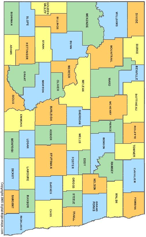
2 METHODOLOGY & TESTING PROCEDURE Bartlett & West is committed to using the MidStates VRS system going forward into We realize that having a state wide VRS will mean a savings of time on our projects which will translate into a direct savings in cost for our clients here in North Dakota. In order to gain a level of confidence with the system and resulting data, Bartlett & West conducted a series of field tests around the central and western parts of the state. For this testing, we were primarily looking to answer three specific questions: First, how well does the data repeat to itself? Second, how well does the data repeat to existing published control data? Third, how easy and effective is the system to set up and use? Based on our meeting with the NDDOT and Frontier Precision, it was determined that existing control points from various NDDOT projects spread around the central and western parts of the state should be used as the control set. Primary survey control for the NDDOT is based on an NGS OPUS Solution. The vast majority of our internal projects at Bartlett & West are also tied to control which is based on OPUS Solutions. 20 NDDOT highway projects were selected in 18 counties, six survey crew chiefs participated in the testing. Data was gathered between October 28, 2015 and November 16, 2015 on 69 monuments, including NGS and NDDOT OPUS primary control points. Between one and seven control monuments were occupied for each of the highway projects selected. Three NGS horizontal monuments were also selected (Discovery II monuments), as well as the four NGS benchmarks in Bismarck and Mandan. All GPS poles were checked for plumb and heights were verified prior to any field work. Job files were created with Trimble Access and utilized the US State Plane 1983 North Dakota Zones (North or South) Geoid12A, Int. ft. settings. All data in the field was collected in grid coordinates. Each crew was assigned several counties to verify either NGS or NDDOT OPUS published data. Once monuments were recovered and determined to be undisturbed, a Trimble R10 rover and bi-pod were placed and leveled on an indicated center point. All measurements were taken using a minimum 180 epochs (approximately three minute measurement). Each monument was occupied at two separate occasions, with a minimum of four hours between measurements. A majority of the monuments were measured on separate days rd St S Fargo, ND MidStatesVRS.com
3
4
5 Data Summary The mean horizontal residual of all test points surveyed was The mean vertical residual of all test points surveyed was Northing Mean = Standard Deviation = sigma = to sigma = to Comparison of B&W surveyed points Easting Mean = Standard Deviation = sigma = to sigma = to Elevation Mean = Standard Deviation = sigma = to sigma = to Comparison of avg. B&W surveyed points to published data Northing Mean = Standard Deviation = sigma = to sigma = to Easting Mean = Standard Deviation = sigma = to sigma = to Conclusion We were very satisfied with the results when comparing the data as surveyed by Bartlett & West in the test study, which shows a high confidence level of repeatability of the VRS system. In comparing our averaged data to the published control data, we anticipated approximately double the values of the B&W data, which it generally was. Some of the causes include: the NDDOT control monuments have been in the ground a number of years; a variety of consulting firms performed the OPUS solutions; OPUS solutions are based on a least squares adjustment using CORS stations; etc. Setting up the Trimble equipment for the VRS system is just a matter of creating a Survey Style, GNSS contact, and Wi-Fi connection. This took less than ten minutes of setup time, with instruction provided by Frontier Precision. Job startup in the field is no different than standard GPS RTK procedures, with the exception of verifying a proper Wi-Fi connection and selecting your broadcast format before performing work. We now have sufficient data to use in the future when we setup our company standards at Bartlett & West. Going forward in 2016 our internal project control will be utilizing the Midstates VRS system in place of OPUS solutions. With no base GPS to setup, the VRS system speeds up field operations, causing a significant increase in efficiencies in longer/larger projects, which in turn will save our clients time and money. Elevation Mean = Standard Deviation = sigma = to sigma = to rd St S Fargo, ND MidStatesVRS.com
Town of Chino Valley. Survey Control Network Report. mgfneerhg mc N. Willow Creek Road Prescott AZ
 Town of Chino Valley Survey Control Network Report mgfneerhg mc. 2050 N. Willow Creek Road Prescott AZ 86301 928-771-2376 Page 1 of 70 Table of Contents Town of Chino Valley Survey Datum Outline A short
HORIZONTAL PROJECTION PARAMETERS: DANE COUNTY COORDINATES
 Recommended RTK GPS Configuration Parameters for the City of Madison, WI Base Station Compiled by: Dan Rodman RLS, City of Madison (608)266-6674 drodman@cityofmadison.com For base station information see
Using UNAVCO Real-Time CORS Data, a No-Cost Positioning Resource
 Using UNAVCO Real-Time CORS Data, a No-Cost Positioning Resource By: Mark Silver, ms@igage.com, +1-801-412-0011 Date: 19 August 2014 UNAVCO is a non-profit consortium of Universities that coordinates the
Meeting the ODOT Survey & Mapping Specifications
 Meeting the ODOT Survey & Mapping Specifications A Simple Solution Presented by Ray Foos, P.S, ODOT CADD & Mapping Services & Jon Keller, P.S., ODOT District 3 Phases of an ODOT Survey Project Research
SURVEYING AND MAPPING, INC. COORDINATE DATA SHEET JOB: CITY OF DECATUR CLIENT: CITY OF DECATUR SAM JOB#:
 13 March 2001 SURVEYING AND MAPPING, INC. COORDINATE DATA SHEET JOB: CITY OF DECATUR CLIENT: CITY OF DECATUR SAM JOB#: 21038-20 HORIZONTAL DATUM: NAD-83 GEODETIC VERTICAL STATION ID LATITUDE LONGITUDE
NATRF 2022 AND LDP OCTOBER 11, 2017
 NATRF 2022 AND LDP OCTOBER 11, 2017 MODERNIZATION OF THE NSRS Why? Leaving passive control marks behind and relying solely on the CORS network for 3D positions: Older methodology relies on terrestrial
GRAVITY SURVEY TEELS MARSH PROSPECT
 GRAVITY SURVEY over the TEELS MARSH PROSPECT MINERAL COUNTY, NV for Dajin Resources (US) Corp. March 2015 SUBMITTED BY Magee Geophysical Services LLC 465 Leventina Canyon Road Reno, Nevada 89523 USA TEL
TOWARDS ROBUST LOCALIZATION OF RTK-GPS TOPOGRAPHIC SURVEYS 23
 TOWARDS ROBUST LOCALIZATION OF RTK-GPS TOPOGRAPHIC SURVEYS Jerry W. Nave, North Carolina A&T University; Tarig A. Ali, American University of Sharjah Abstract Localization is performed to fit the observed
Low Distortion Projections Part 2 Ground versus Grid
 Blue Marble Geographic Calculator provides an incredible variety of tools for working with an infinite combination of datums and projections. Shown here, I ve entered the parameters for a Low Distortion
GISC3325 Spring 2011 Final Exam
 GISC3325 Spring 2011 Final Exam Name: Carefully read each question. Identify the important elements and the question being asked. Show your work for partial credit. No credit for undocumented wrong answers.
4 Survey Datums. 4.1 Horizontal Datum Policy SURVEY DATUMS SEPTEMBER 2006
 4 Survey Datums Today s multi-organizational Project Development efforts require the use of common, accurate horizontal and vertical survey datums and consistent, precise control-survey procedures to ensure
Technical Support: Data Submission
 Why do we want your data? How should I observe data for submission? The objective behind data submissions is to leverage ongoing field work to provide industry with an up-todate network of NAD83 (CSRS)
How GNSS Signals are Impacted by Environmental Factors. MSPS 61 st Annual Meeting Bloomington Minnesota February 8, 2013
 How GNSS Signals are Impacted by Environmental Factors MSPS 61 st Annual Meeting Bloomington Minnesota February 8, 2013 Objectives Identify Negative Environmental Factors Useful Tools to Stack the Deck
Approaches to GNSS & Geodesy
 Approaches to GNSS & Geodesy Ray Hintz Univ. of Maine Ray.hintz@.maine.edu The biggest complaint about state plane coordinates The concept that scale and elevation factor need to be applied to the pythagoreum
Achieving Great Height with GNSS
 Achieving Great Height with GNSS Oregon GPS Users Group 2015 Annual Meeting January 23, 2015 Salem, Oregon Salem Convention Center Michael Dennis, RLS, PE Oregon State University National Geodetic Survey
Preventing Coordinate- System Confusion (maybe?)
") Preventing Coordinate- System Confusion (maybe?) Montana Association of Registered Land Surveyors 2008 Convention Bozeman, Montana 07 & 08 February 2008 Glenn Borkenhagen Inland GPS Inc. - Cody, Wyoming
Preventing Coordinate- System Confusion (maybe?) Montana Association of Registered Land Surveyors 2008 Convention Bozeman, Montana 07 & 08 February 2008 Glenn Borkenhagen Inland GPS Inc. - Cody, Wyoming
Exploring the boundaries of your built and natural world. Geomatics
 Exploring the boundaries of your built and natural world Geomatics Before the Luxor brought magic to the Las Vegas strip and before the South LRT extension in Edmonton gave residents a new route to travel,
Survey of the Bwlch of Craig Bron-banog
 Survey of the Bwlch of Craig Bron-banog 31 October 2014 The Team: John Barnard, Graham Jackson, and Myrddyn Phillips 1) Introduction Craig Bron-banog (Hill Number 3358, Section 30C, 1:50000 OS Map 116,
Principles of the Global Positioning System Lecture 23
 12.540 Principles of the Global Positioning System Lecture 23 Prof. Thomas Herring 05/12/03 12.540 Lec 23 1 OVERVIEW Run through HW 03. Final lecture: Application area and GPS results Analysis of contemporary
Technical Memorandum #2 Future Conditions
 Technical Memorandum #2 Future Conditions To: Dan Farnsworth Transportation Planner Fargo-Moorhead Metro Council of Governments From: Rick Gunderson, PE Josh Hinds PE, PTOE Houston Engineering, Inc. Subject:
If you aren t familiar with Geographical Information Systems (GIS), you. GIS, when combined with a database that stores response information,
, you. GIS, when combined with a database that stores response information,") Geographical Information Systems in EMS By William E. Ott If you aren t familiar with Geographical Information Systems (GIS), you should take a look at what GIS can offer you as an EMS manager. GIS, when
Geographical Information Systems in EMS By William E. Ott If you aren t familiar with Geographical Information Systems (GIS), you should take a look at what GIS can offer you as an EMS manager. GIS, when
Relative Positional Precision Explained in Everyday Language. Measurement vs. Enumeration. ALTA / ACSM Standards and Kentucky Standards of Practice
 Relative Positional Precision Explained in Everyday Language Todd W. Horton, PE, PLS February 015 Definitions Surveying That discipline which encompasses all methods for measuring, processing, and disseminating
Operational Aspects of GNSS CORS What is a GNSS CORS system used for?
 Please insert a picture (Insert, Picture, from file). Size according to grey field (10 cm x 25.4 cm). Scale picture: highlight, pull corner point Cut picture: highlight, choose the cutting icon from the
KEYSTONE PROPERTY GRAVITY GIS DATABASE. Residual Gravity Looking Down to Northwest
 KEYSTONE PROPERTY GRAVITY - 2018 GIS DATABASE Residual Gravity Looking Down to Northwest James L. Wright M.Sc. May 11, 2018 TABLE OF CONTENTS INTRODUCTION......................... 2 SURVEY PROCEDURE......................
Preliminary Microgravity Measurement Of Paka Geothermal Prospect
 Preliminary Microgravity Measurement Of Paka Geothermal Prospect Presented by: Levi Shako and Calistus Ndongoli Date: 4/November/2016 Venue: Addis Ababa, Ethiopia Introduction Microgravity is a geophysical
GPS- vs. DEM-Derived Elevation Estimates from a Hardwood Dominated Forest Watershed
 Journal of Geographic Information System, 2010, 2, 147-151 doi:10.4236/jgis.2010.23021 Published Online July 2010 (http://www.scirp.org/journal/jgis) GPS- vs. DEM-Derived Elevation Estimates from a Hardwood
H.A.R.S. PRA #1 (Historic Area Remediation Site)
") H.A.R.S. PRA #1 (Historic Area Remediation Site) 2009 Multibeam Bathymetry TABLE OF CONTENTS Page LIST OF TABLES 2 LIST OF FIGURES 3 1.0 INTRODUCTION 4 2.0 OBJECTIVE 4 3.0 PROCEDURE 4 3.1 DATA ACQUISITION
H.A.R.S. PRA #1 (Historic Area Remediation Site) 2009 Multibeam Bathymetry TABLE OF CONTENTS Page LIST OF TABLES 2 LIST OF FIGURES 3 1.0 INTRODUCTION 4 2.0 OBJECTIVE 4 3.0 PROCEDURE 4 3.1 DATA ACQUISITION
MODERNIZATION OF THE NSRS
 NATRF 2022 AND LDP SEPTEMBER 12, 2017 MODERNIZATION OF THE NSRS Why? Leaving passive control marks behind and relying solely on the CORS network for 3D positions: Older methodology relies on terrestrial
NGS Data Sheets for Rifle HARN Points
 NGS Data Sheets for Rifle HARN Points DATABASE = Sybase,PROGRAM = datasheet, VERSION = 6.98 1 National Geodetic Survey, Retrieval Date = MARCH 17, 2004 ***********************************************************************
Scott A. True Project Scientist Geodesy & Geophysics Division Basic and Applied Research Office InnoVision Directorate
 EGM96 Variable Resolution Geoid Implementation Error in GEOTRANS 2.3 Scott A. True Project Scientist Geodesy & Geophysics Division Basic and Applied Research Office InnoVision Directorate Introduction
The National Spatial Reference System of the Future
 The National Spatial Reference System of the Future William Stone Southwest Region (AZ, NM, NV, UT) Geodetic Advisor william.stone@noaa.gov NOAA s National Geodetic Survey geodesy.noaa.gov Salt Lake City
Geospatial Data Standards Considerations for the delivery of 2D and 3D spatial data February 2019
 Geospatial Data Standards Considerations for the delivery of 2D and 3D spatial data February 2019 Prepared by: GRCA Geomatics Version Date Summary of Changes Changes Made By: 1.00 March 16, 2018 Version
Fusion of Geodesy and GIS at NOAA s National Geodetic Survey
 Fusion of Geodesy and GIS at NOAA s National Geodetic Survey Esri Survey Summit July 6-9, 2013 San Diego, CA Michael Dennis, RLS, PE michael.dennis@noaa.gov The Plan Background NGS Data Explorer New Datasheet
Mapping Utilities with Mobile GIS Applications
 Mapping Utilities with Mobile GIS Applications Kristy M. Capobianco Reynolds, Smith and Hills, Inc. GIS Analyst Kristy.Capobianco@rsandh.com (904) 256-2251 2007 ESRI Southeast User Group Conference May
An Assessment of the Accuracy of PPP in Remote Areas in Oman
 An Assessment of the Accuracy of PPP in Remote Areas in Oman Rashid AL ALAWI, Sultanate of Oman and Audrey MARTIN, Ireland Keywords: GNSS, PPP, Oman Survey Infrastructure SUMMARY Traditionally, high accuracy
Localization & Grid to Ground Scale Factors in SurvCE
 Localization & Grid to Ground Scale Factors in SurvCE Mark Silver, ms@igage.com, +1-801-412-0011 x16, blog.ashgps.com Grid-to-Ground CSF is function of: Latitude, Elevation and Projection Difficult to
LiDAR Remote Sensing Data Collection Department of Geology and Mineral Industries OLC Sandy December 5, 2011
 LiDAR Remote Sensing Data Collection Department of Geology and Mineral Industries OLC Sandy December 5, 2011 SSubmi itttted tto:: Depaarrttmentt off Geologgyy aand Minerraal l Indussttrri I iess 800 NE
CONTROL MONUMENT REPORT
 CONTROL MONUMENT REPORT This document was prepared by Altus Geomatics for use by City of Yorkton staff and contractors working in and for the City of Yorkton. This document is meant to inform readers about
A303 Stonehenge Amesbury to Berwick Down Archaeological Geophysical Survey Design Brief
 A303 Stonehenge Amesbury to Berwick Down Archaeological Geophysical Survey Design Brief March 2016 Table of contents Chapter Pages 1 Summary 1 2 Background 1 2.1 Purpose 1 2.2 Location 2 2.3 Archaeological
VT State Plane. Daniel J. Martin National Geodetic Survey VT Geodetic Advisor. VSLS Conference Rutland VT April 11, 2008
 VT State Plane Daniel J. Martin National Geodetic Survey VT Geodetic Advisor VSLS Conference Rutland VT April 11, 2008 Today s Outline Define the problem Review of VT State Plane System Relationship
BUILDING AN ACCURATE GIS
 BUILDING AN ACCURATE GIS 2006 GIS in the Rockies Denver, Colorado September 13, 2006 William E. Linzey United States Department of Commerce National Oceanic and Atmospheric Administration National Geodetic
G002 An Integrated Regional Framework for Seismic Depth Imaging in the Deepwater Gulf of Mexico
 G002 An Integrated Regional Framework for Seismic Depth Imaging in the Deepwater Gulf of Mexico M. Davidson (Fugro Multi Client Services), M. Leander (Fugro Multi Client Services), K. Mohn (Fugro Multi
MODERNIZATION OF THE MUNICIPAL MAPPING USING HIGH END GNSS SYSTEM AND GIS SOFTWARE
 MODERNIZATION OF THE MUNICIPAL MAPPING USING HIGH END GNSS SYSTEM AND GIS SOFTWARE Mr. R. A. R. Khan Assistant Engineer, Sewerage Utility Management Centre (SUMC) Municipal Corporation Of Greater Mumbai
Building a Local Transverse Mercator (LTM) Grid aligned with MGA94 for use in GNSS and GIS Richard Stanaway
 Grid aligned with MGA94 for use in GNSS and GIS Richard Stanaway") Building a Local Transverse Mercator (LTM) Grid aligned with MGA94 for use in GNSS and GIS Richard Stanaway Quickclose What is an LTM? An LTM (Local Transverse Mercator) is a working Plane Grid Used for
Building a Local Transverse Mercator (LTM) Grid aligned with MGA94 for use in GNSS and GIS Richard Stanaway Quickclose What is an LTM? An LTM (Local Transverse Mercator) is a working Plane Grid Used for
PRESENTATION TITLE. Drone Magnetic Site Surveys To Verify Wellhead Locations David M. Velozzi 9/27/18
 1 PRESENTATION TITLE Drone Magnetic Site Surveys To Verify Wellhead Locations David M. Velozzi 9/27/18 Speaker Information David M. Velozzi Geoscience Team Lead Magnetic Variation Services (MagVAR) (A
Mapping the Badlands. Surveying and GIS Just Got Easier. >> By Deral Paulk, LS
 $4.95 Mapping the Badlands Surveying and GIS Just Got Easier Surveying and mapping here in southwestern Oklahoma can be a challenge. It s a rough-hewn landscape with rugged terrain features and plenty
Show Me the Money. >> By Robert L. Young, LS
 Show Me the Money here is a lot of talk about the role that GIS plays in business, and in society at large. I d like to talk about what GIS means to surveyors, at least to this surveyor: my experience
Lake Champlain Richelieu River Flood Inundation Mapping and Forecasting Tool
 Lake Champlain Richelieu River Flood Inundation Mapping and Forecasting Tool Rob Flynn USGS New England Water Science Center, NH/VT Office U.S. Department of the Interior U.S. Geological Survey Lake Champlain
NGS and the Modernization of the National Spatial Reference System (NSRS)
") NGS and the Modernization of the National Spatial Reference System (NSRS) Dr. Dana Caccamise Pacific Southwest Region (CA,NV) Geodetic Advisor dana.caccamise@noaa.gov NOAA s National Geodetic Survey geodesy.noaa.gov
NGS and the Modernization of the National Spatial Reference System (NSRS) Dr. Dana Caccamise Pacific Southwest Region (CA,NV) Geodetic Advisor dana.caccamise@noaa.gov NOAA s National Geodetic Survey geodesy.noaa.gov
EXTREMELY FAST IP USED TO DELINEATE BURIED LANDFILLS. Norman R. Carlson, Cris Mauldin Mayerle, and Kenneth L. Zonge
 EXTREMELY FAST IP USED TO DELINEATE BURIED LANDFILLS Norman R. Carlson, Cris Mauldin Mayerle, and Kenneth L. Zonge Zonge Engineering and Research Organization, Inc. 3322 East Fort Lowell Road Tucson, Arizona,
SOURCE: NAVD88 (Computed using GEOID12B)
") Shared Solution https://www.ngs.noaa.gov/opus/getdatasheet.jsp?pid=... 1 of 1 10/2/2018, 2:52 PM Shared Solution PID: Designation: NYKT R1 Stamping: NYKT R1 2005 Stability: May hold commonly subject to
Shared Solution https://www.ngs.noaa.gov/opus/getdatasheet.jsp?pid=... 1 of 1 10/2/2018, 2:52 PM Shared Solution PID: Designation: NYKT R1 Stamping: NYKT R1 2005 Stability: May hold commonly subject to
CADASTRAL DELIMITATION OF ADMINISTRATIVE TERRITORY IN ROMANIA IN ORDER TO ACHIEVE GENERAL URBAN PLANS
 CADASTRAL DELIMITATION OF ADMINISTRATIVE TERRITORY IN ROMANIA IN ORDER TO ACHIEVE GENERAL URBAN PLANS Lecturer PhD. eng. MAGDOLNA EVA KONCSAG, 1 Decembrie 1918 University of Alba Iulia, Romania ABSTRACT.
Location Restriction Demonstration
 Location Restriction Demonstration R.M. Heskett Station Coal Ash Landfill Prepared for Montana-Dakota Utilities Company October 2018 Minneapolis, MN, Bismarck, ND Location Restrictions Demonstration October
ESTIMATES OF HORIZONTAL DISPLACEMENTS ASSOCIATED WITH THE 1999 TAIWAN EARTHQUAKE
 ESTIMATES OF HORIZONTAL DISPLACEMENTS ASSOCIATED WITH THE 1999 TAIWAN EARTHQUAKE C. C. Chang Department of Surveying and Mapping Engineering Chung Cheng Institute of Technology, Taiwan, ROC ABSTRACT A
WEST FROM WASHINGTON
 SEPTEMBER 2018 WEST FROM WASHINGTON Hemisphere GNSS A visit to headquarters Thought Leader Bloomberg out of touch Flood Info Ensure it s correct West from Washington Establishing the 25th and 27th Meridians
NR402 GIS Applications in Natural Resources Lesson 4 Map Projections
 NR402 GIS Applications in Natural Resources Lesson 4 Map Projections From http://www.or.blm.gov/gis/ 1 Geographic coordinates Coordinates are expressed as Latitude and Longitude in Degrees, Minutes, Seconds
3/21/2019. Q: What is this? What is in this area of the country? Q: So what is this? GEOG 3100 Next Week
 Tuesday: Thursday: GEOG 3100 Next Week Discussion of The South region (in this room) GIS Computer Lab Time (ENV Building, Room 340 more on this in class on Tuesday next week) Ahead of this lab time, please
GPS and Mean Sea Level in ESRI ArcPad
 Summary In order to record elevation values as accurately as possible with, it is necessary to understand how ArcPad records elevation. Rather than storing elevation values relative to Mean Sea Level (MSL),
Frames for the Future New Datum Definitions for Modernization of the U.S. National Spatial Reference System
 Figure 10. Horizontal position differences (in meters) between NAD 83 and ITRF 08 at time 2022.00 (January 1, 2022). Positional differences are shown for the North American and Pacific tectonic plates.
MobileMapper 6. White Paper. MobileMapper 6 vs. Juno SC In Real World Conditions. Sub-Meter, Post-Processed Accuracy for less than 1,500 USD
 MobileMapper 6 White Paper MobileMapper 6 vs. Juno SC In Real World Conditions Sub-Meter, Post-Processed Accuracy for less than 1,500 USD Table of Contents Introduction...1 Testing Methodology...2 Test
ch02.pdf chap2.pdf chap02.pdf
 Introduction to Geographic Information Systems 8th Edition Karl Solutions Manual Full Download: http://testbanklive.com/download/introduction-to-geographic-information-systems-8th-edition-karl-solutions-manu
ANALYSIS OF THE SPATIO-TEMPORAL VARIABILITY AND IMPACT OF TROPOSPHERIC DELAY ON THE POSITIONAL ACCURACY IN GNSS PPP OBSERVATIONS
 ANALYSIS OF THE SPATIO-TEMPORAL VARIABILITY AND IMPACT OF TROPOSPHERIC DELAY ON THE POSITIONAL ACCURACY IN GNSS PPP OBSERVATIONS J. O. Odumosu, O. G. Ajayi, Y. D. Opaluwa, I. C. Onuigbo, A.A. Kuta and
Chapter 3 Geographic Location Systems
 Chapter 3 Geographic Location Systems In this chapter you will learn about: Latitude and longitude Universal Transverse Mercator (UTM) U.S. Public Land Survey Other geographic location systems Geographic
GEOIDS FAQ. November
 GEOIDS FAQ 1. What is a geoid? A geoid is a representation of the equipotential surface of the Earth s gravity field. It can be thought of as a surface coinciding with the undisturbed mean sea level extended
Positioning the Pacific: NOAA s Geospatial Activities. Juliana Blackwell, Director NOAA s National Geodetic Survey March 6, 2012
 Positioning the Pacific: NOAA s Geospatial Activities Juliana Blackwell, Director NOAA s National Geodetic Survey March 6, 2012 A Common Problem of the Early 19 th Century 1807 President Thomas Jefferson
REVISED UPDATED PREPARED DIRECT SAFETY ENHANCEMENT COST ALLOCATION TESTIMONY OF GARY LENART SAN DIEGO GAS & ELECTRIC COMPANY AND
 Application No: Exhibit No.: Witness: A.--00 ) In the Matter of the Application of San Diego Gas & ) Electric Company (U 0 G) and Southern California ) Gas Company (U 0 G) for Authority to Revise ) Their
Ground Truth Annual Conference. Design and Documentation of Low Distortion Projections for Surveying and GIS
 Professional Land Surveyors of Oregon 15 Annual Conference Ground Truth Design and Documentation of Low Distortion Projections for Surveying and GIS Michael L Dennis, RLS, PE v. (rev 1), January 15, Design
KIRKLAND LAKE GOLD ANNOUNCES 120 METRE DOWN-PLUNGE EXTENSION OF SWAN ZONE
 KIRKLAND LAKE GOLD ANNOUNCES 120 METRE DOWN-PLUNGE EXTENSION OF SWAN ZONE High-grade, visible-gold mineralization intersected 120 metres ( m ) down-plunge of Swan Zone Inferred Mineral Resource and 210
We re at the height of the homebuying season. Buyers, sellers and bad guys are out in abundance.
 We re at the height of the homebuying season. Buyers, sellers and bad guys are out in abundance. Attempted wire fraud against realtors, lenders and title companies continues to increase. The bad guys now
Lessons Learned from 40 Years of Grid-Sampling in Illinois D.W. Franzen, North Dakota State University, Fargo, ND
 Introduction Lessons Learned from 4 Years of Grid-Sampling in Illinois D.W. Franzen, North Dakota State University, Fargo, ND In 1961 a quietly radical soil sampling project was initiated by Drs. Sig Melsted
Midterm 2. DO NOT turn this page until you are instructed to do so
 University of California Berkeley Handout M2 CS170: Efficient Algorithms and Intractable Problems November 15, 2001 Professor Luca Trevisan Midterm 2 DO NOT turn this page until you are instructed to do
OFFSHORE. Advanced Weather Technology
 Contents 3 Advanced Weather Technology 5 Working Safely, While Limiting Downtime 6 Understanding the Weather Forecast Begins at the Tender Stage 7 Reducing Time and Costs on Projects is a Priority Across
NTS 93L/9W GEOCHEMICAL AND GEOPHYSICAL REPORT MONA CLAIM OMINICA MINING DIVISION. Lati tude 54036'N; Longitude 'W
 GEOCHEMICAL AND GEOPHYSICAL REPORT ON MONA CLAIM OMINICA MINING DIVISION Lati tude 54036'N; Longitude 126018'W NTS 93L/9W April 1981 Paul Plicka Consulting Geologist LOCATION MAP INTRODUCTION TABLE OF
Coastal Flood Risk Study Project for East Coast Central Florida Study Area
 Coastal Flood Risk Study Project for East Coast Central Florida Study Area St Lucie County, Florida Flood Risk Review Meeting March 28, 2017 Introductions Risk MAP Project Team FEMA Region IV BakerAECOM,
TEN YEARS OF DEFORMATION STUDY AND PROPOSED RESEARCH PROGRAM FOR THE AREA OF POLISH COPPER BASIN
 Proceedings, 11 th FIG Symposium on Deformation Measurements, Santorini, Greece, 2003. TEN YEARS OF DEFORMATION STUDY AND PROPOSED RESEARCH PROGRAM FOR THE AREA OF POLISH COPPER BASIN Stanislaw Oszczak
United States NSRS 2022: Terrestrial Reference Frames
 United States NSRS 2022: Terrestrial Reference Frames Daniel ROMAN, U.S.A. Key words: Capacity building; Positioning; Reference frames; Reference systems, Cadastre SUMMARY In 2022, the United States will
A New Approach to Estimating Population Growth Along a Major Arterial Highway.
 . ABSTRACT In the last twenty years Texas has undergone extensive growth as people move across the country and relocate in the Lone Star State. Many of these new Texans choose suburbs outside major cities
MSGIC Spring Mtg Denton April 23, 2014
 Modernization of the National Spatial Reference System Keeping Pace with Changes in Positioning Technology and User Expectations in a Dynamic World MSGIC Spring Mtg Denton April 23, 2014 Dave Doyle Base
OLC Rogue River. LiDAR Remote Sensing Data Final Report, 3 of 3
 OLC Rogue River LiDAR Remote Sensing Data Final Report, 3 of 3 November 5, 2012 Rogue River Valley, Oregon. Data collected for: Department of Geology and Mineral Industries 800 NE Oregon Street Suite 965
A Method for Measuring the Spatial Accuracy of Coordinates Collected Using the Global Positioning System
 This file was created by scanning the printed publication. Errors identified by the software have been corrected; however, some errors may remain. A Method for Measuring the Spatial Accuracy of Coordinates
Tectonic deformations in Greece and the operation of HEPOS network
 Tectonic deformations in Greece and the operation of HEPOS network M. Gianniou KTIMATOLOGIO S.A. (Hellenic Cadastre) Abstract Today, networks of permanent reference stations are broadly used for the realization
Once upon a time.. GY 301: Geomorphology. Alidade & Plane Table. Ray Measurement Geometry. Measurements with the Alidade and Stadia Rod
 UNIVERSITY OF SOUTH ALABAMA GY 301: Geomorphology Once upon a time.. The Alidade and Plane Table Surveying Lecture 10: Total Station Surveying Alidade & Plane Table Measurements with the Alidade and Stadia
Ground-penetrating radar (GPR) and shallow seismic surveys at Calgary International Airport, Alberta
 and shallow seismic surveys at Calgary International Airport, Alberta") Ground-penetrating radar (GPR) and shallow seismic surveys at Calgary International Airport, Alberta Robert R. Stewart, Han-xing Lu, and Don C. Lawton ABSTRACT A ground-penetrating radar survey was conducted
Ground-penetrating radar (GPR) and shallow seismic surveys at Calgary International Airport, Alberta Robert R. Stewart, Han-xing Lu, and Don C. Lawton ABSTRACT A ground-penetrating radar survey was conducted
FORENSIC WEATHER CONSULTANTS, LLC
 MOST INFORMATION HAS BEEN CHANGED FOR THIS SAMPLE REPORT FORENSIC WEATHER CONSULTANTS, LLC Howard Altschule Certified Consulting Meteorologist 1971 Western Avenue, #200 Albany, New York 12203 518-862-1800
How the Length of the Cord Affects the Value of K. Summary:
 Taylor Witherell Partners: Phuong Mai, Matthew Richards Section: 113-01 Date: 7 November 2017 How the Length of the Cord Affects the Value of K Summary: Our goal was to find an equation in terms of the
The Canadian Height Modernization Initiative. Information for British Columbia Stakeholders / Clients
 The Canadian Height Modernization Initiative Information for British Columbia Stakeholders / Clients Introduction A modern society requires the ability to measure elevations relative to mean sea level
GEODESY LESSON PLAN All Shook Up
 All Shook Up Lesson Plan GEODESY LESSON PLAN All Shook Up Focus Displacement of the Earth s crust due to seismic events Grade Level 9-12 Focus Question How can we measure movements in the Earth s crust
Trimble RTX TM Orbit Determination and User Positioning Performance with BeiDou Satellites
 Nick Talbot, Xiaoming Chen, Nico Reussner, Markus Brandl, Markus Nitschke, Carlos Rodriguez-Solano, Feipeng Zhang Trimble Terrasat GmbH IGNSS 2016, SYDNEY, AUSTRALIA Trimble RTX TM Orbit Determination
2013 Cartographic Country Report Uruguay **
 ADVANCE UNEDITED VERSION UNITED NATIONS _ STATISTICS DIVISION E/CONF.103/IP.5 Tenth United Nations Regional Cartographic Conference for the Americas New York, 19-23, August 2013 Item 6(b) of the provisional
Case Study of Japan: Crustal deformation monitoring with GNSS and InSAR
 Technical Seminar Reference Frame in Practice, Case Study of Japan: Crustal deformation monitoring with GNSS and InSAR Basara Miyahara miyahara-b96ip@milt.go.jp Geospatial Information Authority of Japan
This Land Surveying course has been developed by Failure & Damage Analysis, Inc.
 This Land Surveying course has been developed by Failure & Damage Analysis, Inc. www.discountpdh.com DEPARTMENT OF THE ARMY U.S. Army Corps of Engineers CECW-EP Washington, DC 20314-1000 ETL 1110-1-183
Spatial Data Collection using GPS: BEST PRACTICES
 Spatial Data Collection using GPS: BEST PRACTICES - 2007 Page 1 of 10 Best practices for GPS & Spatial Data Collection, Storage and Documentation These Best Practices are designed to maximize positional
Analysis of Physical Oceanographic Data from Bonne Bay, September 2002 September 2004
 Physics and Physical Oceanography Data Report -1 Analysis of Physical Oceanographic Data from Bonne Bay, September September Clark Richards and Brad deyoung Nov. 9 Department of Physics and Physical Oceanography
In Association With. Introduces. TPT Contractor
 In Association With Introduces TPT Contractor Software for Contractors with TENSIONMETERS Table of Contents Capabilities 4 Setup and Use 7 The Dashboard 12 Tower Setup Form 18 Field Calibration Verification
Road Scholar. Williamette Valley Invitational Practice Tournament
 Road Scholar Williamette Valley Invitational Practice Tournament Rules for this Event As you complete this event, enter your answers on the online data sheet. You may click "submit" when done and quietly
The following is an excerpt taken from the history section of the City of New Salem Website (
 The following is an excerpt taken from the history section of the City of New Salem Website (http://www.newsalem-nd.com/ THE SAGA OF NEW SALEM On an April day in 1883, a westbound freight train pulled
Control Surveys and Coordinate Systems
 Control Surveys and Coordinate Systems The Earth is Round Basic Shape of the Earth: Oblate Spheroid of Revolution The length of the equatorial axis is approximately 27 miles greater than the polar axis.
Winds on Titan: First results from the Huygens Doppler Wind Experiment
 1 Winds on Titan: First results from the Huygens Doppler Wind Experiment Supplementary Discussion. It was realized during the DWE design phase that Earth-based Doppler measurements could be combined with
Dealing with significant differential tectonic plate velocities within an RTK-network: The case of HEPOS
 Dealing with significant differential tectonic plate velocities within an RTK-network: The case of HEPOS M. Gianniou, E. Mitropoulou, I. Stavropoulou National Cadastre and Mapping Agency S.A. Mesogion
Kinematic Monitoring for Baselines Ranging from 3m to 30km
 Kinematic Monitoring for Baselines Ranging from 3m to 3km By: Colin Huber Waypoint Consulting Inc. November 23 1. INTRODUCTION This report investigates the accuracy and reliability for the continuous trajectory