Coastal Flood Risk Study Project for East Coast Central Florida Study Area
|
|
|
- Virginia Stevens
- 5 years ago
- Views:
Transcription


1 Coastal Flood Risk Study Project for East Coast Central Florida Study Area St Lucie County, Florida Flood Risk Review Meeting March 28, 2017

2 Introductions Risk MAP Project Team FEMA Region IV BakerAECOM, FEMA Mapping Partner Project Stakeholders Community CEOs Community FPAs Political Representatives Other State and Federal Agencies Public 2
3 Why We Are Here Project Review and Update Data Collected Modeling Approaches Hurricane Surge Overland Wave Analysis Questions and Answers Open Discussion of Draft Work Maps Nassau County, FL 3

4 Project Area Brevard County Indian River County St. Lucie County Martin County 4

5 Why the Coastal Flood Risk Study Is Being Updated Flood risk changes over time Effective study based on outdated hurricane modeling and topographic data Ability to more accurately define risk and account for significant development in project area To gain a complete and current picture of coastal flood risks. This helps community: Plan for the risk Communicate the risk to your citizens Take action to reduce flood risk to lives and property Build smarter and safer 5
6 Why the Coastal Flood Risk Study Is Being Updated (Cont d) Current surge analysis is 30+ years old: SURGE FEMA Coastal Flood Storm Surge Model, last updated in the 1980s Climate data from 1975, 1978, and 1979 NOAA reports Your risk is better defined through: Updated elevation data (topographic data and aerial imagery) New climatological data based on recent storms Computing resources a lot has changed in 30 years! Updated coastal hazard methodologies/modeling Improvement in Geographic Information System (GIS) technologies to improve coastal mapping accuracy 6
7 Outreach Meetings Discovery Meeting May 2012 Technical Update Meeting June 2013 Storm Surge Analysis Update Meeting November 2014 Flood Risk Review Meeting Today 7
 Determined from 2. Amount of wave setup storm surge model 3. Wave height above storm surge elevation 4.")
8 Basic Elements of a Coastal Flood Risk Study Base Flood Elevation (BFE) on FIRM includes four components: 1. Storm surge stillwater elevation (SWEL) Determined from 2. Amount of wave setup storm surge model 3. Wave height above storm surge elevation 4. Wave runup above storm surge elevation (where present) 8

9 Gathered Field Data Coordinated with community officials and stakeholders regarding available data Conducted thorough data investigation Conducted field investigations for surge and overland wave modeling efforts 9
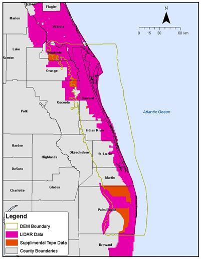
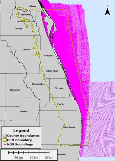
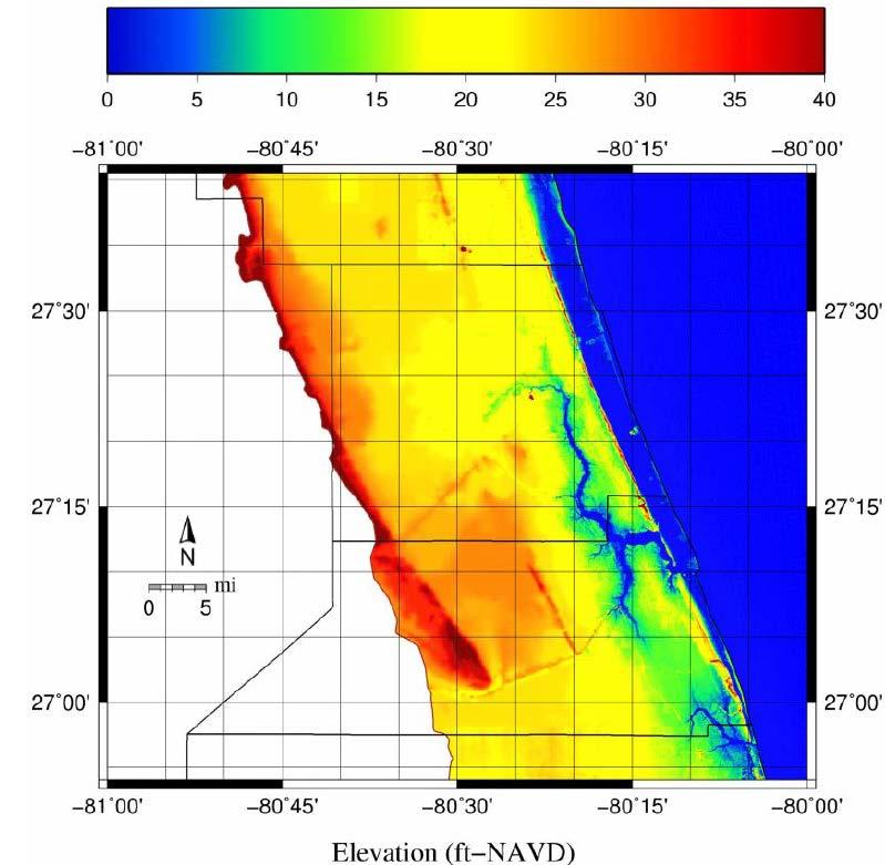
10 Topographic and Bathymetric Data 10

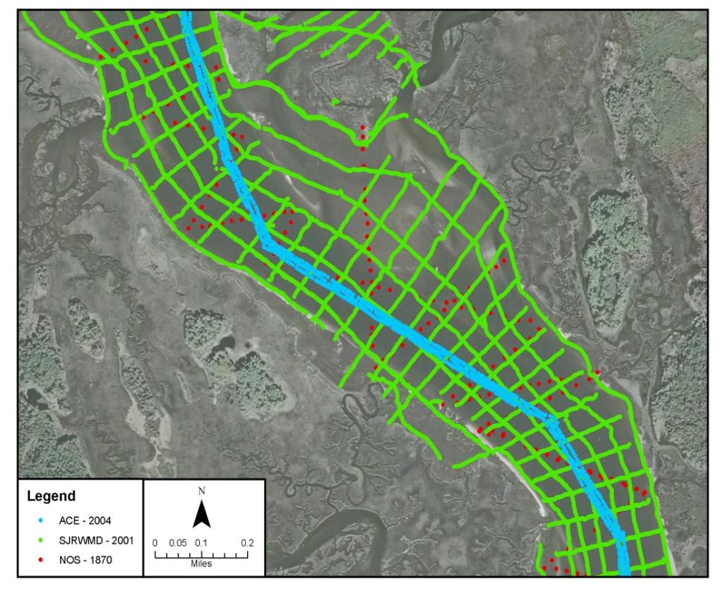
11 Topographic and Bathymetric Data 11

12 Hurricane Model Mesh Development 12
 Offshore: 80 200 m (260 655 ft) Western Boundary: 1 5 km (3,000 16,000")
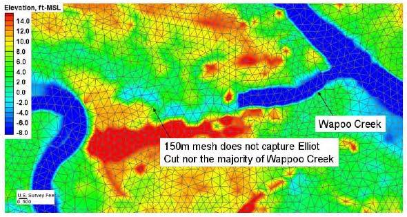
13 Seamless Digital Elevation Model Mesh Resolution 1,406,658 Nodes Complex Terrain / Developed Areas: m ( ft) Offshore: m ( ft) Western Boundary: 1 5 km (3,000 16,000 ft) 13


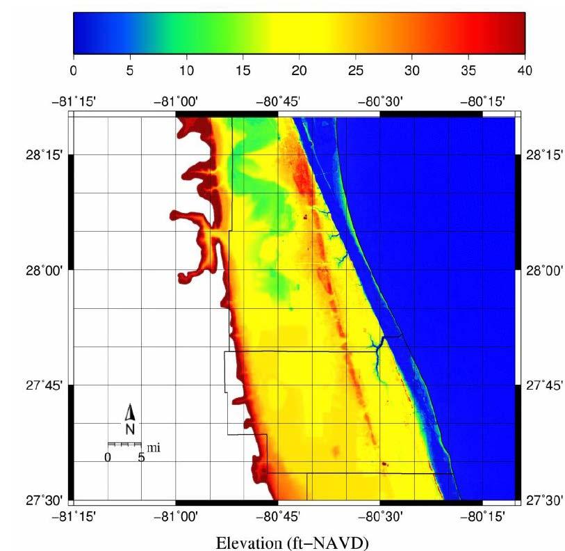
14 14 Seamless Digital Elevation Model

15 Hurricane Model Mesh St. Lucie County Fort Pierce Inlet, FL 15
 Fort Pierce")
16 Hurricane Model Mesh St. Lucie County (Cont d) Fort Pierce Inlet, FL ICWW A1A 16

17 Hurricane Model Mesh Development 17

 Node spacing 100")
18 Comparison of Old and New Mesh Node spacing ~3000 feet (0.5 nm) Node spacing feet 18
19 Hurricane Modeling Validate tidal elevation modeling Review historical storms Use historic storms to validate the hurricane/surge model Generate hundreds of hypothetical storms 19

20 Validation Storm Selection: Tidal Elevations Astronomical tides simulated based on 8 tidal constituents Modeled Tides compared to 10 NOAA Stations Agreement based on amplitude and phase 20

21 Storm Climatology: In Study Area Tropical Storms: Passing within 175 nm of Melbourne, FL Limited data before

22 Storm Climatology: In Study Area Significant Events Storm type Landfalling Bypassing Exiting 22

23 Validation Storm Selection: Significant Surge Events 23

24 Validation Storm Selection: Significant Surge Events (Cont d) 24
 2. Hurricane Frances (2004) 3. Hurricane Jeanne (2004) 4. Tropical Storm Tammy (2005) 5.")
25 Validation Storm Selection: Significant Surge Events (Cont d) Five Validation Storms Selected 1. Hurricane Irene (1999) 2. Hurricane Frances (2004) 3. Hurricane Jeanne (2004) 4. Tropical Storm Tammy (2005) 5. Hurricane Wilma (2005) 25

26 Validation Storm Selection: Significant Surge Events (Cont d) 26
27 Validation: Summary Validation completed for tides and five historical storms Demonstrated model capability to reproduce water levels and waves in project area Comparisons to available data showed reasonable agreement for water levels and waves 27
28 Hypothetical Storms Developed Using Five Parameters 1. Central pressure 2. Radius to maximum winds 3. Forward speed 4. Storm heading 5. Holland s B (shape parameter) Simulated Whole Range of Possible Storms for FL (Based on Historic Data for Area) Run Storms on High-Speed Computer Performed Quality Control of Results 28

29 Surge Modeling Gives 1-Percent-Annual- Chance SWELs, St. Lucie County Set up mesh for hurricane/surge model Validated hurricane/surge model Ran hundreds of hypothetical storms Computed return periods for study area Result: storm surge stillwater elevations for 1-percentannual-chance event 29
30 Overland Wave Analysis 30


31 St. Lucie County Transects 31

32 WHAFIS and Mapping 32


33 WHAFIS Modeling and Mapping 33


34 Wave Runup Modeling and Mapping 34
35 Wave Runup Modeling 35


36 Primary Frontal Dune (PFD) a continuous or nearly continuous mound or ridge of sand with relatively steep seaward and landward slopes immediately landward and adjacent to the beach and subject to erosion and overtopping from high tides and waves during major coastal storms NFIP regulations 36

37 Limit of Moderate Wave Action (LiMWA) FEMA Procedure Memorandum No. 50, 2008 At present not a regulatory requirement No Federal insurance requirements tied to LiMWA CRS benefit for communities requiring VE zone construction standards in areas defined by LiMWA or areas subject to waves greater then 1.5 feet 37

38 Combined Probability Mapping Coastal Riverine 38

39 Combined Probability Mapping (Cont d) 39

40 Combined Probability Mapping (Cont d) 40

41 Work Maps Example 41

42 Work Maps Example (Cont d) 42

43 Changes Since Last FIRM - Example 43

44 Upcoming Schedule 44
45 Timeline for Implementation Flood Risk Review Meetings Held: Today Preliminary FIRMs and FIS Reports Delivered: May 2017 CCO Meetings and Flood Risk Open Houses Held: June Day Appeal Periods Started: September 2017 Letters of Final Determination Issued: March 2018 FIRMs and FIS Reports Distributed: May 2018 Resilience Meetings Held: May 2018 FIRMs and FIS Reports Effective: September

46 Study Updates on FEMA Web Portal 46
 220-5450")
")

47 Coastal Flood Risk Study Contacts Mark Vieira, PE (770) Chris Mack, PE, PMP (843) Paul Carroll, PE

48 Open Discussion 48
Coastal Flood Risk Study Project for Northeast Florida Study Area
 Coastal Flood Risk Study Project for Northeast Florida Study Area Duval County, Florida Flood Risk Review Meeting September 22, 2015 Introductions Risk MAP Project Team FEMA Region IV BakerAECOM, FEMA
Storm Surge Analysis Update Meeting Charlotte and DeSoto Counties, Florida March 7, 2018
 Southwest Florida Coastal Storm Surge Study Storm Surge Analysis Update Meeting Charlotte and DeSoto Counties, Florida March 7, 2018 Agenda Introductions Goals for Today SWFL Coastal Surge Study Study
Storm Surge Analysis Update Meeting Cross City, Florida June 17, 2014
 Big Bend Coastal Storm Surge Study Storm Surge Analysis Update Meeting Cross City, Florida June 17, 2014 Introductions Risk MAP Project Team FEMA Region IV Florida Division of Emergency Management (FDEM)
Storm Surge Analysis Update Meeting Hillsborough and Manatee Counties April 5, 2016
 West Florida Coastal Storm Surge Study Storm Surge Analysis Update Meeting Hillsborough and Manatee Counties April 5, 2016 Agenda Introductions Goals for Today West Florida Coastal Surge Study Project
Location: Jacksonville, FL December 11, 2012
 Technical Update Meeting Northeast Florida Surge Study Location: Jacksonville, FL December 11, 2012 Agenda 2:00 2:15 Welcome/Introductions Tucker Mahoney, FEMA Region IV Michael DelCharco, BakerAECOM 2:15
2016 NC Coastal Local Governments Annual Meeting
 6 NC Coastal Local Governments Annual Meeting NCFMP Coastal Map Maintenance Flood Study Updates and Changes April, 6 Tom Langan, PE, CFM Engineering Supervisor NCEM-Risk Management - Floodplain Mapping
Georgia and Northeast Florida Coastal Storm Surge and Mapping Study: Continued Progress Amid Challenges
 Georgia and Northeast Florida Coastal Storm Surge and Mapping Study: Continued Progress Amid Challenges Presented by Christopher Bender, Ph.D., P.E., D.CE June 12, 2013 Presentation Overview FEMA risk
FEMA REGION III COASTAL HAZARD STUDY
 FEMA REGION III COASTAL HAZARD STUDY Impacts and Rollout June 11, 2013 Robin Danforth, FEMA Region III David Bollinger, FEMA Region III Jeff Gangai, RAMPP Christine Worley, RAMPP 1 Today s Discussion Overview
Final Results and Outreach Lessons Learned
 FEMA REGION III COASTAL HAZARD STUDY Final Results and Outreach Lessons Learned June 4, 2014 Mari Radford Christine Worley Robin Danforth David Bollinger FEMA Region III RAMPP FEMA Region III FEMA Region
Storm Induced Coastal Erosion for Flood Insurance Studies and Forecasting Coastal Flood Damage Impacts: Erosion, Runup & Overtopping
 Storm Induced Coastal Erosion for Flood Insurance Studies and Forecasting Coastal Flood Damage Impacts: Erosion, Runup & Overtopping Jeff Gangai- Dewberry Tucker Mahoney FEMA HQ Introduction Background
Miami-Dade County Technical Update Meeting South Florida Coastal Study. May 11, 2016
 Miami-Dade County Technical Update Meeting South Florida Coastal Study May 11, 2016 Welcome and Introductions FEMA Region IV Christina Lindemer Technical Lead Production and Technical Services (PTS) Contractor
SWAN+ADCIRC Mesh Flagler County
 SWAN+ADCIRC Mesh Flagler County 61 SWAN+ADCIRC Mesh Flagler County 62 SWAN+ADCIRC Mesh Flagler County Pellicer Creek, FL 63 SWAN+ADCIRC Mesh Flagler County Pellicer Creek, FL 64 SWAN+ADCIRC Mesh Volusia
Ed Curtis, PE, CFM, FEMA Region IX and Darryl Hatheway, CFM, AECOM ASFPM 2016, Grand Rapids, MI
 Methodology to Determine Process-Based Total Water Level Profiles in Areas Dominated by Wave Runup Ed Curtis, PE, CFM, FEMA Region IX and Darryl Hatheway, CFM, AECOM ASFPM 2016, Grand Rapids, MI Thurs.
HURRICANE JEANNE CHARACTERISTICS and STORM TIDE EVALUATION
 HURRICANE JEANNE CHARACTERISTICS and STORM TIDE EVALUATION ((DRAFT)) By Robert Wang and Michael Manausa Sponsored by Florida Department of Environmental Protection, Bureau of Beaches and Coastal Systems
Draft for Discussion 11/11/2016
 Coastal Risk Consulting (CRC) Climate Vulnerability Assessment for Village of Key Biscayne Deliverable 1.1 in Statement of Work. Preliminary Vulnerability Assessment Identifying Flood Hotspots Introduction...
Coastal Flood Hazard Mapping
 Coastal Flood Hazard Mapping Current Status and Update April 4, 2017 NCFMP Program Objectives Purpose: Develop, Maintain, and Disseminate current, accurate, digital flood hazard data for all of NC, to
South Florida Coastal Storm Surge and Mapping Study
 South Florida Coastal Storm Surge and Mapping Study Presented by Christopher Bender, Ph.D., P.E., D.CE June 2, 2015 Presentation Overview FEMA risk studies outline Overview South Florida surge study Work
COASTAL DATA APPLICATION
 2015 Coastal GeoTools Proactive By Design. Our Company Commitment COASTAL DATA APPLICATION Projecting Future Coastal Flood Risk for Massachusetts Bay Bin Wang, Tianyi Liu, Daniel Stapleton & Michael Mobile
HURRICANE FRANCES CHARACTERISTICS and STORM TIDE EVALUATION
 HURRICANE FRANCES CHARACTERISTICS and STORM TIDE EVALUATION ((DRAFT)) By Robert Wang and Michael Manausa Sponsored by Florida Department of Environmental Protection, Bureau of Beaches and Coastal Systems
Flood and Sea Level Rise Mapping Methodologies: The Way Forward
 Flood and Sea Level Rise Mapping Methodologies: The Way Forward Malcolm L. Spaulding Professor Emeritus, Ocean Engineering University of Rhode Island spaulding@egr.uri.edu Interagency Coordination Meeting
CAPE MAY COUNTY, NEW JERSEY (All Jurisdictions)
") VOLUME 1 OF 1 CAPE MAY COUNTY, NEW JERSEY (All Jurisdictions) COMMUNITY NAME COMMUNITY NUMBER AVALON, BOROUGH OF 345279 CAPE MAY, CITY OF 345288 CAPE MAY POINT, BOROUGH OF 345289 DENNIS, TOWNSHIP OF 340552
VOLUME 1 OF 1 CAPE MAY COUNTY, NEW JERSEY (All Jurisdictions) COMMUNITY NAME COMMUNITY NUMBER AVALON, BOROUGH OF 345279 CAPE MAY, CITY OF 345288 CAPE MAY POINT, BOROUGH OF 345289 DENNIS, TOWNSHIP OF 340552
Protecting the Storm Damage Prevention and Flood Control Interests of Coastal Resource Areas
 Protecting the Storm Damage Prevention and Flood Control Interests of Coastal Resource Areas Presented by: Massachusetts Department of Environmental Protection & Massachusetts Office of Coastal Zone Management
SOUTHEAST COASTAL ASSESSMENT: Creating a shared vision
 SOUTHEAST COASTAL ASSESSMENT: Creating a shared vision November 12, 2017 Jacqueline Keiser, PG, PMP Regional Sediment Management Regional Center of Expertise SOUTH ATLANTIC DIVISION U.S. ARMY CORPS OF
SOMERSET COUNTY, MARYLAND
 SOMERSET COUNTY, MARYLAND AND INCORPORATED AREAS COMMUNITY NAME CID NUMBER CRISFIELD, CITY OF 240062 PRINCESS ANNE, TOWN OF 240063 SOMERSET COUNTY (UNINCORPORATED AREAS) 240061 Somerset County PRELIMINARY:
Introduction to Risk MAP NYC Coastal Study
 Introduction to Risk MAP NYC Coastal Study FEMA REGION II October 18, 2012 Alan Springett, Senior Engineer 1 Agenda Components of FEMA Region II Coastal Surge Analysis Overview of entire process at a glance
Probabilistic Assessment of Coastal Storm Hazards
 Resilience of Coastal Infrastructure Conference Hato Rey, PR March 8-9, 2017 Probabilistic Assessment of Coastal Storm Hazards Dr. Norberto C. Nadal-Caraballo Leader, Coastal Hazards Group Team: Victor
Randall W. Parkinson, Ph.D., P.G. Institute of Water and Environment Florida International University
 An Update on Adaptation Action Activities Undertaken Since Completion of the City of Satellite Beach (FL) Vulnerability Assessment to Rising Seas (2010) Randall W. Parkinson, Ph.D., P.G. Institute of Water
Dealing with Zone A Flood Zones. Topics of Discussion. What is a Zone A Floodplain?
 Dealing with Zone A Flood Zones Topics of Discussion Overview of Zone A Floodplains Permitting Development in Zone A Floodplains Estimating Flood Elevations in Zone A Flood Insurance Implications Letters
FLOOD INSURANCE STUDY
 FLOOD INSURANCE STUDY RICHMOND COUNTY, VIRGINIA AND INCORPORATED AREAS COMMUNITY NAME COMMUNITY NUMBER RICHMOND COUNTY (UNINCORPORATED AREAS) 510310 * WARSAW, TOWN OF 510115 *No Special Flood Hazard Areas
CITY OF PORTSMOUTH, VIRGINIA (INDEPENDENT CITY)
") CITY OF PORTSMOUTH, VIRGINIA (INDEPENDENT CITY) City of Portsmouth PRELIMINARY JANUARY 13, 2014 REVISED: Federal Emergency Management Agency FLOOD INSURANCE STUDY NUMBER 515529V000B NOTICE TO FLOOD INSURANCE
CITY OF PORTSMOUTH, VIRGINIA (INDEPENDENT CITY) City of Portsmouth PRELIMINARY JANUARY 13, 2014 REVISED: Federal Emergency Management Agency FLOOD INSURANCE STUDY NUMBER 515529V000B NOTICE TO FLOOD INSURANCE
CAMDEN COUNTY, GEORGIA
 CAMDEN COUNTY, GEORGIA AND INCORPORATED AREAS COMMUNITY NAME COMMUNITY NUMBER CAMDEN COUNTY 130262 (UNINCORPORATED AREAS) KINGSLAND, CITY OF 130238 ST. MARYS, CITY OF 130027 WOODBINE, CITY OF 130241 CAMDEN
Hurricane Shelter Standards Governors Hurricane Conference 2018
 Hurricane Shelter Standards Governors Hurricane Conference 2018 Partnership with Florida Local Level State Level Hurricane Evacuation Studies Hurricane Evacuation Study Fresh Water Flooding Storm Surge
Appendix E Guidance for Shallow Flooding Analyses and Mapping
 Appendix E Guidance for Shallow Flooding Analyses and Mapping E.1 Introduction Different types of shallow flooding commonly occur throughout the United States. Types of flows that result in shallow flooding
Mapping of Future Coastal Hazards. for Southern California. January 7th, David Revell, Ph.D. E.
 Mapping of Future Coastal Hazards for Southern California January 7th, 2014 David Revell, Ph.D. drevell@esassoc.com E. Vandebroek, 2012 Outline Coastal erosion hazard zones Flood hazard zones: Coastal
Michelle Burnett, RI State Floodplain Manager Jess Stimson, RI Floodplain Mapping Coordinator
 The Sandy-est Aftermath: A Rhode Island Perspective After Hurricane Sandy Michelle Burnett, RI State Floodplain Manager Jess Stimson, RI Floodplain Mapping Coordinator June 13, 2013 Rhode Island Background
Background and Purpose of Meeting. River Towers Meeting. Flood Risk Management Study Alternatives Overview
 1 and Purpose of Meeting River Towers Meeting Flood Risk Management Study Alternatives Overview September 23, 2014 There is no "proposed" flood risk management solution for this area at this time Fairfax
Ground Water Protection Council 2017 Annual Forum Boston, Massachusetts. Ben Binder (303)
") Ground Water Protection Council 2017 Annual Forum Boston, Massachusetts Protecting Groundwater Sources from Flood Borne Contamination Ben Binder (303) 860-0600 Digital Design Group, Inc. The Problem Houston
Ground Water Protection Council 2017 Annual Forum Boston, Massachusetts Protecting Groundwater Sources from Flood Borne Contamination Ben Binder (303) 860-0600 Digital Design Group, Inc. The Problem Houston
New Jersey Department of Transportation Extreme Weather Asset Management Pilot Study
 New Jersey Department of Transportation Extreme Weather Asset Management Pilot Study Overview Prepared for: June 26, 2018 Introduction Overview of Pilot Study New Jersey s Climate New Jersey s Transportation
Sea level rise Web GIS Applications
 Florida International University FIU Digital Commons GIS Center GIS Center 2018 Sea level rise Web GIS Applications Zhaohui Fu GIS-RS Center, Florida International University, Fujen@fiu.edu Sheyla Santana
ARMSTRONG COUNTY, PA
 ARMSTRONG COUNTY, PA Revised Preliminary DFIRM Mapping March 31, 2013 Kevin Donnelly, P.E., CFM GG3, Greenhorne & O Mara, Inc. Presentation Agenda Armstrong County DFIRM Overview - June 25, 2010 DFIRM
SECTION 5: RISK ASSESSMENT FLOOD. Table of Contents
 Table of Contents SECTION 5 Risk Assessment... 5-1 5.1 Hazard Profile... 5-1 5.2 Hazard Description... 5-1 Previous Occurrences and Losses... 5-39 Probability of Future Occurrences... 5-56 Climate Change
FLOOD INSURANCE STUDY
 FLOOD INSURANCE STUDY CHARLES CITY COUNTY, VIRGINIA AND INCORPORATED AREAS COMMUNITY NAME COMMUNITY NUMBER CHARLES CITY COUNTY (UNINCORPORATED AREAS) 510198 Charles City County REVISED DATE Preliminary
Racing against time, an unprecedented year: the US Army Corps of Engineers (USACE) response to the hurricanes of 2004
 response to the hurricanes of 2004") Environmental Problems in Coastal Regions VI 205 Racing against time, an unprecedented year: the US Army Corps of Engineers (USACE) response to the hurricanes of 2004 R. I. McMillen 1, D. R. Haubner 2,
Environmental Problems in Coastal Regions VI 205 Racing against time, an unprecedented year: the US Army Corps of Engineers (USACE) response to the hurricanes of 2004 R. I. McMillen 1, D. R. Haubner 2,
Turn and Face the Strange: Economic Impacts of Climate Change Sea Level Rise and Coastal Flooding E2Tech Forum June 21, 2018
 Turn and Face the Strange: Economic Impacts of Climate Change Sea Level Rise and Coastal Flooding E2Tech Forum June 21, 2018 Peter A. Slovinsky, Marine Geologist Maine Geological Survey Image from Chebeague.org
COUNTY, DICTIONS) 44001CV000B COMMUNITY COMMUNITY NUMBER BRISTOL, TOWN
 44001CV000B COMMUNITY COMMUNITY NUMBER BRISTOL, TOWN") BRISTOL COUNTY, RHODE ISLAND (ALL JURISD DICTIONS) COMMUNITY NAME BARRINGTON, TOWN OF BRISTOL, TOWN OF WARREN, TOWN OF COMMUNITY NUMBER 445392 445393 445408 Federal Emerge ency Management Agency FLOOD
BRISTOL COUNTY, RHODE ISLAND (ALL JURISD DICTIONS) COMMUNITY NAME BARRINGTON, TOWN OF BRISTOL, TOWN OF WARREN, TOWN OF COMMUNITY NUMBER 445392 445393 445408 Federal Emerge ency Management Agency FLOOD
GREENE COUNTY, PA. Revised Preliminary DFIRM Mapping FEMA. Kevin Donnelly, P.E., CFM GG3, Greenhorne & O Mara, Inc. April 10, 2013
 GREENE COUNTY, PA Revised Preliminary DFIRM Mapping April 10, 2013 Kevin Donnelly, P.E., CFM GG3, Greenhorne & O Mara, Inc. Presentation Agenda Greene County DFIRM Overview September 30, 2010 DFIRM Countywide
Tropical Update 6 AM EDT Friday, October 7, 2016 Hurricane Matthew & Hurricane Nicole
 Tropical Update 6 AM EDT Friday, October 7, 2016 Hurricane Matthew & Hurricane Nicole This update is intended for government and emergency response officials, and is provided for informational and situational
Sea Level Rise and Hurricane Florence storm surge research methodology
 Sea Level Rise and Hurricane Florence storm surge research methodology Hurricane Florence storm surge analysis was conducted using a variety of input sources. In order to determine the maximum storm surge
Tropical Update. 12 PM EDT Friday, October 7, 2016 Hurricane Matthew & Tropical Storm Nicole
 Tropical Update 12 PM EDT Friday, October 7, 2016 Hurricane Matthew & Tropical Storm Nicole This update is intended for government and emergency response officials, and is provided for informational and
3301 Rickenbacker Causeway, Miami, FL 33149
 Virginia Key and Miami Beach 2016 King Tide Report and Projections (to 2045) using: 3301 Rickenbacker Causeway, Miami, FL 33149 *THIS REPORT IS PROVIDED SUBJECT TO THE COASTAL RISK CONSULTING, LLC, PRINTED
US Army Corps of Engineers BUILDING STRONG. Mary Cialone, Norberto Nadal-Caraballo, and Chris Massey
 North Atlantic Coast Comprehensive Study Storm Selection and Numerical Modeling An Overview Computing the Joint Probability of Storm Forcing Parameters from Maine to Virginia Mary Cialone, Norberto Nadal-Caraballo,
ASFPM - Rapid Floodplain Mapping
 ASFPM - Nicole Cominoli Hydraulic Engineer USACE - Omaha District mary.n.cominoli@usace.army.mil June 3, 2015 US Army Corps of Engineers Mitigation = Risk Informed Decisions 2 The National Flood Insurance
FLOOD INSURANCE STUDY
 FLOOD INSURANCE STUDY NEW KENT COUNTY, VIRGINIA AND INCORPORATED AREAS COMMUNITY NAME COMMUNITY NUMBER NEW KENT COUNTY (UNINCORPORATED AREAS) 510306 New Kent REVISED DATE Preliminary Date: January 31,
Risk Identification using Hazus
 Risk Identification using Hazus City of Boston, Suffolk County, MA Dave Shortman, GISP, CFM 6/21/2016 Agenda Objective Project Location Hazus Overview Hazus Level 2 Risk Assessment Comparison and Reporting
Base Level Engineering FEMA Region 6
 Base Level Engineering Over the past five years, has been evaluating its investment approach and data preparation work flow to establish an efficient and effective change in operation, generating an approach
Hurricane Harvey: Texas Coastal Erosion Hot Spot Analysis
 Hurricane Harvey: Texas Coastal Erosion Hot Spot Analysis Texas ASBPA Symposium April 24, 2018 Alan Johnson, FEMA Chris Levitz, Compass Agenda Introduction Hurricane Harvey Erosion Hot Spot Analysis Purpose
Major Hurricane Matthew Briefing Situation Overview
 Major Hurricane Matthew Briefing Situation Overview THIS IS NOW A WORST CASE STORM SURGE SCENARIO Catastrophic Damage is Anticipated for Coastal Areas. Major Hurricane Matthew is still expected to move
HURRICANE CHARLEY CHARACTERISTICS and STORM TIDE EVALUATION
 HURRICANE CHARLEY CHARACTERISTICS and STORM TIDE EVALUATION By Robert Wang, Michael Manausa And Jenny Cheng Sponsored by Florida Department of Environmental Protection, Bureau of Beaches and Coastal Systems
HVX-HURREVAC (Beta) Webinar Series
 Webinar Series") HVX-HURREVAC (Beta) Webinar Series Day 1 - An introduction to HURREVAC and the new web-based HVX platform 2018 HVX-HURREVAC Webinar Series 1. Intro to HURREVAC and General Overview of the Program (August
HVX-HURREVAC (Beta) Webinar Series Day 1 - An introduction to HURREVAC and the new web-based HVX platform 2018 HVX-HURREVAC Webinar Series 1. Intro to HURREVAC and General Overview of the Program (August
COASTAL FLOODING IMPACT REPORT (100-YEAR RETURN PERIOD EVENT) CORDECO DISCOVERY BAY RESORT & MARINA BO. ESPINAL, AGUADA, P.R.
 CORDECO DISCOVERY BAY RESORT & MARINA BO. ESPINAL, AGUADA, P.R.") COASTAL FLOODING IMPACT REPORT (100-YEAR RETURN PERIOD EVENT) CORDECO DISCOVERY BAY RESORT & MARINA BO. ESPINAL, AGUADA, P.R. submitted to CORDECO NORTHWEST CORP. 2305 LAUREL ST. SAN JUAN, P.R. 00913 by
COASTAL FLOODING IMPACT REPORT (100-YEAR RETURN PERIOD EVENT) CORDECO DISCOVERY BAY RESORT & MARINA BO. ESPINAL, AGUADA, P.R. submitted to CORDECO NORTHWEST CORP. 2305 LAUREL ST. SAN JUAN, P.R. 00913 by
Climate Risk Visualization for Adaptation Planning and Emergency Response
 Climate Risk Visualization for Adaptation Planning and Emergency Response NCR Flood Fact Finding Workshop Ricardo Saavedra ricardo@vizonomy.com Social Media, Mobile, and Big Data St. Peter s Basilica,
SLOSH New Orleans Basin 2012 Update
 SLOSH New Orleans Basin 2012 Update Michael Koziara Science and Operations Officer National Weather Service Slidell, LA The Basics What is storm surge? What is SLOSH? Details Assumptions Inundation = Storm
DIVISION OF COASTAL MANAGEMENT TO STUDY CURRENT LONG-TERM EROSION RATES ADJACENT TO TERMINAL GROINS
 DIVISION OF COASTAL MANAGEMENT TO STUDY CURRENT LONG-TERM EROSION RATES ADJACENT TO TERMINAL GROINS North Carolina Department of Environmental Quality Division of Coastal Management February 22, 2018 N.
VOLUME 3 OF 3 FAIRFIELD COUNTY, OHIO AND INCORPORATED AREAS COMMUNITY NAME NUMBER COMMUNITY NAME NUMBER
 VOLUME 3 OF 3 FAIRFIELD COUNTY, OHIO AND INCORPORATED AREAS COMMUNITY NAME NUMBER COMMUNITY NAME NUMBER AMANDA, VILLAGE OF * 390688 PICKERINGTON, CITY OF 390162 BALTIMORE, VILLAGE OF 390159 PLEASANTVILLE,
John Callahan (Delaware Geological Survey) Kevin Brinson, Daniel Leathers, Linden Wolf (Delaware Environmental Observing System)
 Kevin Brinson, Daniel Leathers, Linden Wolf (Delaware Environmental Observing System)") John Callahan (Delaware Geological Survey) Kevin Brinson, Daniel Leathers, Linden Wolf (Delaware Environmental Observing System) Delaware is extremely vulnerable to the impacts of coastal flooding Tropical
John Callahan (Delaware Geological Survey) Kevin Brinson, Daniel Leathers, Linden Wolf (Delaware Environmental Observing System) Delaware is extremely vulnerable to the impacts of coastal flooding Tropical
LOMR SUBMITTAL LOWER NESTUCCA RIVER TILLAMOOK COUNTY, OREGON
 LOMR SUBMITTAL LOWER NESTUCCA RIVER TILLAMOOK COUNTY, OREGON Prepared for: TILLAMOOK COUNTY DEPARTMENT OF COMMUNITY DEVELOPMENT 1510-B THIRD STREET TILLAMOOK, OR 97141 Prepared by: 10300 SW GREENBURG ROAD,
Appendix C Fluvial Flood Hazards
 Appendix C Fluvial Flood Hazards Sea Level Rise Vulnerability Assessment and Adaptation Project March 2019 Contents Contents... i Figures... i Tables... i Definitions, Acronyms, & Abbreviations... ii
US Army Corps of Engineers BUILDING STRONG
 Greater New Orleans Hurricane and Storm Damage Risk Reduction System Robert Rowlette Senior Senior Program Manager Task Force Hope U.S. Army Corps of Engineers April 19, 2012 US Army Corps of Engineers
Coastal Inundation Risk for SE Florida Incorporating Climate Change Impact on Hurricanes & Sea Level Rise
 Coastal Inundation Risk for SE Florida Incorporating Climate Change Impact on Hurricanes & Sea Level Rise Y. Peter Sheng and V.A. Paramygin Justin R. Davis, Andrew Condon, Andrew Lapetina, Tianyi Liu,
Phase II Storm Surge Analysis
 Phase II Storm Surge Analysis Post 45 Project, Charleston, SC Prepared for: USACE Charleston District Charleston, SC Prepared by: Water Environment Consultants Mount Pleasant, SC October 21, 2016 Table
5.2 IDENTIFICATION OF HAZARDS OF CONCERN
 5.2 IDENTIFICATION OF HAZARDS OF CONCERN 2015 HMP Update Changes The 2010 HMP hazard identification was presented in Section 6. For the 2015 HMP update, the hazard identification is presented in subsection
Regional Sediment Management
 Regional Sediment Management Linda S. Lillycrop Program Manager Coastal Engineer US Army Engineer Research and Development Center Coastal and Hydraulics Laboratory Q AVG Coastal Resilience: The Environmental,
Coastal Hazard Assessment for the Lowermost Mississippi River Management Program
 Coastal Hazard Assessment for the Lowermost Mississippi River Management Program USACE ERDC Coastal and Hydraulics Laboratory Mary Cialone Chris Massey Norberto Nadal USACE Mississippi Valley Division
Document Title. Estimating the Value of Partner Contributions to Flood Mapping Projects. Blue Book
 Document Title Estimating the Value of Partner Contributions to Flood Mapping Projects Blue Book Version 1.1 November 2006 Table of Contents 1. Background...1 2. Purpose...1 3. Overview of Approach...2
Sea-level Rise on Cape Cod: How Vulnerable Are We? Rob Thieler U.S. Geological Survey Woods Hole, MA
 Sea-level Rise on Cape Cod: How Vulnerable Are We? Rob Thieler U.S. Geological Survey Woods Hole, MA Outline Sea-level and coastal processes Past sea-level change Predictions for the future Coastal responses
Hurricane Wilma Post Storm Data Acquisition Estimated Peak Wind Analysis and Storm Tide Data. December 27, 2005
 Hurricane Wilma Post Storm Data Acquisition Estimated Peak Wind Analysis and Storm Tide Data December 27, 2005 Hurricane Wilma was the sixth major hurricane of the record-breaking 2005 Atlantic hurricane
Florida Flood Risks. Heavy Rainfall. Groundwater. Tidal Flooding. Storm Surge. King Tides. Runoff/Riverine
 Florida Flood Risks Heavy Rainfall Storm Surge Groundwater Tidal Flooding Runoff/Riverine King Tides Sawgrass Mills Mall Sunrise, Florida 15 of rain in 3 days, with most in 24 hours. Mall closed for 3
Evaluation of Storm Tide Measurements at Panama City Beach, FL
 Evaluation of Storm Tide Measurements at Panama City Beach, FL 1993-2007 Prepared by Mark E. Leadon Beaches and Shores Resource Center Florida State University May 2009 Prepared for Florida Department
Hurricanes and Storm Surge : Before coming to lab, visit the following web site:
 Geol 108 Lab #7 Week of October 15-19, 2012 Coastal Studies Hurricanes and Storm Surge : Before coming to lab, visit the following web site: http://www.usatoday.com/graphics/weather/gra/gsurge/flash.htm
NORTH ATLANTIC COAST COMPREHENSIVE STUDY (NACCS) STORM MODELING AND STATISTICAL ANALYSIS FOR
 STORM MODELING AND STATISTICAL ANALYSIS FOR") NORTH ATLANTIC COAST COMPREHENSIVE STUDY (NACCS) STORM MODELING AND STATISTICAL ANALYSIS FOR 237 237 217 217 200 200 80 27 252 174.59 COMPUTING 255 0 163 COASTAL 131 239 110 HAZARDS 112 62 255 255 0 0
NORTH ATLANTIC COAST COMPREHENSIVE STUDY (NACCS) STORM MODELING AND STATISTICAL ANALYSIS FOR 237 237 217 217 200 200 80 27 252 174.59 COMPUTING 255 0 163 COASTAL 131 239 110 HAZARDS 112 62 255 255 0 0
Tracking Storm Tide and Coastal Flooding During Hurricane Matthew
 Tracking Storm Tide and Coastal Flooding During Hurricane Matthew Stephen Harden, Jeanne Robbins, and Eric Frantz U.S. Geological Survey, South Atlantic Water Science Center Presented to: WRRI Annual Conference
Adaptation to Sea Level Rise A Regional Approach
 Adaptation to Sea Level Rise A Regional Approach Project Partners: in Saco Bay, ME Peter Slovinsky, Marine Geologist Maine Geological Survey, Department of Conservation Project Funding from: Saco Bay Hazards
Tropical Update. 5 AM EDT Tuesday, September 12, 2017 Post-Tropical Cyclone Irma, Hurricane Jose, & Tropical Wave (10%)
") Tropical Update 5 AM EDT Tuesday, September 12, 2017 Post-Tropical Cyclone Irma, Hurricane Jose, & Tropical Wave (10%) This update is intended for government and emergency response officials, and is provided
Tropical Update 5 AM EDT Tuesday, September 12, 2017 Post-Tropical Cyclone Irma, Hurricane Jose, & Tropical Wave (10%) This update is intended for government and emergency response officials, and is provided
Development of Operational Storm Surge Guidance to Support Total Water Predictions
 Development of Operational Storm Surge Guidance to Support Total Water Predictions J. Feyen 1, S. Vinogradov 1,2, T. Asher 3, J. Halgren 4, Y. Funakoshi 1,5 1. NOAA/NOS//Development Laboratory 2. ERT,
Application #: TEXT
 TOWN OF FORT MYERS BEACH 2008 PROPOSED COMPREHENSIVE PLAN AMENDMENTS Application #: 2008-13-TEXT Description: Modify the Coastal Management and Future Land Use Elements to reflect the state s new definition
Impacts of Hurricane Rita on the Beaches of Western Louisiana
 Impacts of Hurricane Rita on the Beaches of Western Louisiana By Hilary F. Stockdon, Laura A. Fauver, Asbury H. Sallenger, Jr., and C. Wayne Wright Hurricane Rita made landfall as a category 3 storm in
Hurricanes in a Warming World. Jeff Donnelly Woods Hole Oceanographic Institution
 Hurricanes in a Warming World Jeff Donnelly Woods Hole Oceanographic Institution Hurricanes impacting the NE US Hurricane Sandy Was Hurricane Sandy a freak of nature? Or had we just been lucky? What are
RE: Inadequacy of December 2017 Draft Supplemental Environmental Assessment Review of Recent Storm Events and Flooding
 December 29, 2017 U.S. Corps of Engineers Jacksonville District ATTN: Paul Stodola 701 San Marco Boulevard Jacksonville, Florida 32207-8175 TO: FROM: Paul Stodola U.S. Corps of Engineers Jacksonville District
5.2 IDENTIFICATION OF HAZARDS OF CONCERN
 5.2 IDENTIFICATION OF HAZARDS OF CONCERN 2016 HMP Update Changes The 2011 HMP hazard identification was presented in Section 3. For the 2016 HMP update, the hazard identification is presented in subsection
Peter A. Slovinsky, Marine Geologist Maine Geological Survey Department of Agriculture, Conserva=on and Forestry. Funding from:
 Peter A. Slovinsky, Marine Geologist Maine Geological Survey Department of Agriculture, Conserva=on and Forestry Funding from: 50% 40% Figure modified from Griggs, 2001 10% Global Sea Level Rise Driving
A Perfect Storm: The Collision of Tropical Cyclones, Climate Change and Coastal Population Growth. Jeff Donnelly Woods Hole Oceanographic Institution
 A Perfect Storm: The Collision of Tropical Cyclones, Climate Change and Coastal Population Growth Jeff Donnelly Woods Hole Oceanographic Institution Recent Hurricane Trends What Might the Future Hold?
Florida Statewide Regional Evacuation Study Program
 Florida Statewide Regional Evacuation Study Program Directional Atlas Lafayette County Volume 10-3 Book 4 Florida Division of Emergency Management North Central Florida Regional Planning Council North
Sea Level Rise Pilot Study
 Document Title FEMA Region IX California Coastal Analysis and Mapping Project / Open Pacific Coast Study Sea Level Rise Pilot Study Future Conditions Analysis and Mapping San Francisco County, California
Preliminary Vulnerability Assessment of Coastal Flooding Threats - Taylor County, Florida
 Preliminary Vulnerability Assessment of Coastal Flooding Threats - Taylor County, Florida North Central Florida Regional Planning Council Northeast Florida Regional Council April 28, 2016 BACKGROUND This
THC-T-2013 Conference & Exhibition
 Modeling of Shutter Coastal Protection against Storm Surge for Galveston Bay C. Vipulanandan, Ph.D., P.E., Y. Jeannot Ahossin Guezo and and B. Basirat Texas Hurricane Center for Innovative Technology (THC-IT)
HURRICANE IRENE. CONFERENCE CALL BRIEFING SLIDES Saturday August 27, :30 AM
 HURRICANE IRENE CONFERENCE CALL BRIEFING SLIDES Saturday August 27, 2011 8:30 AM NHC TRACK AND CONE HURRICANE IRENE WATCHES/WARNINGS Hurricane Warning along south coast including all of Cape Cod and Islands
TROPICAL STORM NATE BRIEFING
 TROPICAL STORM NATE BRIEFING 5:00 AM CDT Friday, October 6, 2017 Prepared by: NWS NWSNewOrleans www.weather.gov/neworleans Situation Overview No significant changes to the track forecast this morning.
Flood Insurance Study
 Flood Insurance Study Grant County, Arkansas Status Meeting November 17, 2010, 2pm Grant County OES/EOC 130 Grant 74, Sheridan, AR 72150 1 Presentation Overview Introduction FEMA Risk MAP Update Study
NOAA s National Weather Service Philadelphia/Mt. Holly NJ
 Next Briefing Package: Friday, October 2, 2015 no later than 300 PM Hazards and Impacts: Overview: A dangerous weather pattern still threatens our region. Threats include very heavy rainfall, inland river
YELLOWSTONE RIVER FLOOD STUDY REPORT TEXT
 YELLOWSTONE RIVER FLOOD STUDY REPORT TEXT TECHNICAL REPORT Prepared for: City of Livingston 411 East Callender Livingston, MT 59047 Prepared by: Clear Creek Hydrology, Inc. 1627 West Main Street, #294