Storm Surge Analysis Update Meeting Charlotte and DeSoto Counties, Florida March 7, 2018
|
|
|
- Antony Whitehead
- 5 years ago
- Views:
Transcription


1 Southwest Florida Coastal Storm Surge Study Storm Surge Analysis Update Meeting Charlotte and DeSoto Counties, Florida March 7, 2018


2 Agenda Introductions Goals for Today SWFL Coastal Surge Study Study Overview & Schedule Storm Surge Methodology Stillwater Elevation Information Risk MAP Overview & Products Next Steps Meet to Gather Input Town of Fort Myers Beach Hickory Mound Unit Bokeelia Fishing Pier 2


3 Welcome Risk MAP Project Team FEMA RAMPP (study contractor) Project Stakeholders State partners and officials Officials from local communities CEOs / Elected Officials Floodplain Administrators Engineers Emergency Planners Universities Other Federal agency representatives Non-governmental organizations City of Cape Coral Pine Island near Edison Preserve 3
4 Goals for Today Promote engagement with the communities Discuss the Southwest Florida Coastal Surge Study and the status of the study Discuss the study methodology and results Mesh Development Storm Climatology Validation Storms Stillwater Elevations Gather technical input and feedback from you 4

5 FEMA Region IV Coastal Studies 5

6 Study Overview: Surge Study Area Counties in the Study Area Sarasota DeSoto Charlotte Lee Hendry Collier 6
7 Study Overview: Project Schedule Completed Discovery Kickoff Meeting: February 2014 Discovery Meeting: March 2014 Mesh Review Meeting: September 2014 Storm Surge Analysis Update Meeting: Today Currently Ongoing Overland Wave Modeling (WHAFIS): Spring/Summer 2018 Upcoming Flood Risk Review Meeting: Summer 2018 Preliminary Flood Insurance Rate Maps:
8 Reason for Surge Update Flood risk changes over time Effective surge analysis is based on older hurricane modeling and topographic data Sarasota: 1978 (FEMA s Standard Surge Model) Charlotte: 1976 (US Dept. of Commerce s SPLASH model) Lee: 1984 (FEMA s Standard Surge Model) Collier: 2009 (FEMA s Standard Surge Model) Study area was selected due to risk and ongoing studies Significant flood risk from coastal storms (hurricanes, tropical storms) Increase in population and development since Effective coastal FIRMs were published Ongoing riverine watershed flood studies 8


9 Example of FEMA Standard Surge Model vs ADCIRC FEMA Standard Surge Model Cells are 1500 ft x 1500 ft ADCIRC Mesh Spacing 90 ft to 300 ft 9
10 Reason for Surge Update Your flood risk is better defined through: Updated topographic elevation data and aerial imagery New climatological data based on recent storms Updated coastal hazard methodologies/modeling Improvement in GIS technologies to improve coastal mapping accuracy To gain a complete and current picture of coastal flood risks. This helps the community: Plan for the risk Communicate the risk to your citizens Take action to reduce flood risk to lives and property build smarter and safer 10


11 Reason for Surge Update Different methods and goals from the 2010 FDEM Surge Study 2010 FDEM Evacuation Study FY 13 FEMA Surge Study Inundation levels for evacuation planning Mapping 1% annual chance flood hazard Included entire Florida coast Focus on Southwest Florida counties Base data includes recent LiDAR data Base data includes recent LiDAR data SLOSH model ADCIRC and SWAN models Example Evacuation Map Example Coastal SFHA Workmap 11
12 Project Overview: IDS Submittals IDS1 Field Reconnaissance Digital Elevation Model (DEM) Development of ADCIRC Mesh Storm Climatology Validation Storm Selection IDS2 Tide & Storm Validation Statistical Method Development IDS3 Production Runs Return Period Analysis Stillwater Elevations Starting Wave Conditions IDS4 and IDS5 Nearshore Hydraulics Draft Flood Hazard Mapping Mesh Review Meeting (Sept 2014) All Hands Meeting (Feb 2015) Report Review (Feb/March 2015) All Hands Meeting (Oct 2015) Report Review (Feb Nov 2017) SSAU Meeting (Today) Flood Risk Review Meeting (Summer/Fall 2018) 12
13 Storm Surge Approach (IDS1 IDS3) Storm Forcing - Hurricane Tracks Storm Surge Modeling Winds Waves Water Levels High-Resolution Bathy / Topo Mesh Return Period Analysis JPM-OS 10%, 4%, 2%, 1%, & 0.2% annual chance Tide Gage Analysis 50% & 20% annual chance Still Water Elev. JPM-OS = Joint Probability Method- Optimum Sampling 13


14 IDS1 Recap: Field Reconnaissance 72 locations in study area Applied this data during mesh development 14

15 IDS1 Recap: Digital Elevation Model Shoreline Topographic Data LiDAR FWC Enhanced Elevation National Elevation Dataset Bathymetric Data NOAA GEOphysical Data Management System Electronic Navigational Charts USACE Hydro Survey 15

16 IDS1 Recap: Development of ADCIRC Mesh ADCIRC = ADvanced CIRCulation model Finite element model Unstructured, triangulated mesh Node spacing set to accurately represent underlying topo/bathy Feature arcs created to represent important topographic features ARCIRC Mesh 16

17 IDS1 Recap: Development of ADCIRC Mesh Peace River 17

18 IDS1 Recap: Development of ADCIRC Mesh Peace River 18

19 IDS1 Recap: Development of ADCIRC Mesh Punta Gorda 19

20 IDS1 Recap: Development of ADCIRC Mesh Punta Gorda 20

21 IDS1 Recap: Development of ADCIRC Mesh Lemon Bay, Little Gasparilla Island 21

22 IDS1 Recap: Development of ADCIRC Mesh Lemon Bay, Little Gasparilla Island 22

23 IDS1 Recap: Storm Climatology Reviewed historical storms Selected tropical storms to validate the hurricane / surge model Generated hundreds of synthetic storms LandFall Storm Population and Tracks 23
 Hurricane Charley (2004) Selected based on peak surge and available")
24 IDS1 Recap: Validation Storm Selection Storms Selected: Hurricane Donna (1960) Tropical Storm Gabrielle (2001) Hurricane Charley (2004) Selected based on peak surge and available data 24
25 IDS2 Recap: Tide & Storm Validation elevation (ft NAVD88) Validation Data: Tide harmonic constituent data Surge descriptions and measurements Water level gages High Water Marks Wave buoy data Simulated and known tides Simulated and recorded surge elevations and wave characteristics for three historical storms measured modeled modeled-measured Comparison of PWEs for all storms Surge Elevations at Fort Myers during Gabrielle /10/ :00 9/11/ :00 9/12/ :00 9/13/ :00 9/14/ :00 9/15/ :00 25

26 IDS2 Recap: Statistical Method Development Developed probabilistic model for the occurrence and characteristics of hurricanes that generate significant surge along SWFL coast Generated the JPM-OS storm set of representative synthetic storms 26
27 IDS3: Production Runs Simulation of synthetic tropical cyclones using ADCIRC+SWAN Total of 395 synthetic storms (hurricanes and tropical storms) Time steps selected based on model efficiency and stability ADCIRC time step = 1 second SWAN time step = 15 minutes Simulations executed at random start times to represent the effects of astronomical tides Steric effect determined using NOAA s seasonal trend data 27
 Determined from overland wave modeling All applied to an eroded beach profile (when applicable) The above components")
28 Basic Elements of a Coastal Study Base Flood Elevation (BFE) on a FIRM includes 4 components: Storm surge stillwater elevation (SWEL) Wave setup Determined from storm surge model Wave height above total stillwater elevation Wave runup above storm surge elevation (where present) Determined from overland wave modeling All applied to an eroded beach profile (when applicable) The above components are computed through Terrain processing and profile erosion Storm surge study for SWELs determination Coastal Hazard Analysis 28
29 IDS3: Return Period Analysis Processed results of the production runs to develop: Coastal Stillwater Elevations (SWELs) for the 50-, 20-, 10-, 4-, 2-, 1-, and 0.2-percent-annual-exceedance flood levels Wave heights and periods for the 1- and 0.2-percent-annual-exceedance flood levels Developed surge-frequency curves for tropical cyclones from the production runs output For 10-, 4-, 2-, 1-, and 0.2-percent-annual-exceedance flood levels Analyzed historical NOAA water level gages For 50- and 20-percent-annual-exceedance flood levels 29

30 IDS3: Return Period Analysis At the WFL/SWFL boundary: blended flood levels to obtain a smooth transition 30
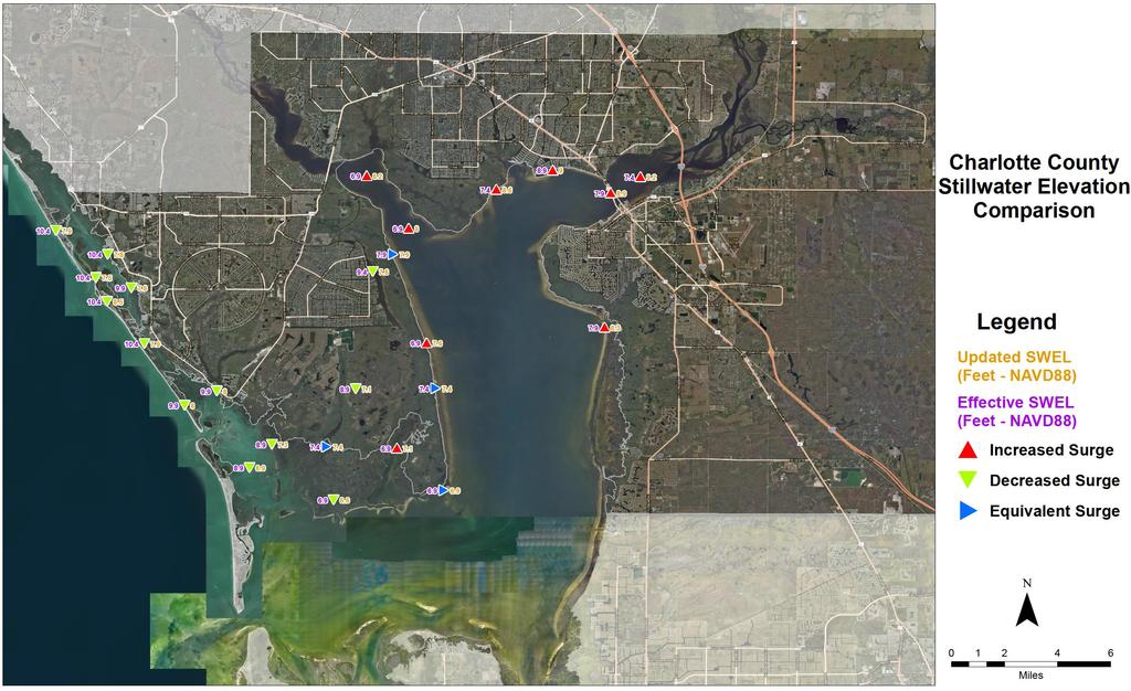
31 IDS3: Stillwater Elevations Calculated 1-percent-annual-chance stillwater elevations (SWELs) These are intended to give you an idea of the results we are seeing Comparison to Effective SWELs Does not correlate directly to what the FIRM may show because the published SWEL does not include wave heights Effective SWEL locations are approximate Results are variable throughout study area 31

32 IDS3: Stillwater Elevations 32
33

34 IDS3: Starting Wave Conditions Determined starting wave conditions to be used in the subsequent overland analysis Starting Wave Heights for 1-percent SWEL Starting Wave Periods for 1-percent SWEL 34

 Develop draft work maps Develop Risk MAP")
35 Upcoming Work IDS4: Overland Wave Modeling IDS5: Mapping Special Flood Hazard Areas Base Flood Elevations (BFEs) Limit of Moderate Wave Action (LiMWA) Develop draft work maps Develop Risk MAP nonregulatory products 35

36 Basic Elements of a Coastal Study 36

37 Limit of Moderate Wave Action (LiMWA) FEMA Procedure Memorandum No. 50, 2008 & Operating Guidance At present not a regulatory requirement No Federal Insurance requirements tied to LiMWA CRS benefit for communities requiring VE Zone construction standards in areas defined by LiMWA or areas subject to waves greater than 1.5 feet 37


38 Primary Frontal Dune (PFD) a continuous or nearly continuous mound or ridge of sand with relatively steep seaward and landward slopes immediately landward and adjacent to the beach and subject to erosion and overtopping from high tides and waves during major coastal storms NFIP regulations 38
39 Risk MAP Program Overview FEMA works with communities to develop flood risk products and flood hazard maps that are: Based on the best available data from the community and latest technologies Conducted by watershed (Riverine) Conducted by affected communities and counties (Coastal) Strengthened by partnerships You can use Risk MAP tools and data to: Create or improve your Local Mitigation Strategies Make informed decisions about development, ordinances, and flood mitigation projects Communicate with citizens about flood risk 39


40 Risk MAP Products Regulatory Products Non-Regulatory Products DFIRM Database Traditional products are regulatory and subject to statutory due-process requirements Risk MAP products are nonregulatory and are not subject to statutory due-process requirements 40

41 Risk MAP Products: Flood Risk Map Visually Promotes Risk Awareness Contains results of Risk MAP project non-regulatory datasets Promotes additional flood risk data not shown but located within the Flood Risk Database 41

42 Risk MAP Products: Changes Since Last FIRM Makes it easy for communities and homeowners to identify impacts of new FIRM Assists in prioritizing mitigation actions Helps identify reasons for changes 42
43 Work Breakdown Work to be done by RAMPP (PTS): Support Discovery and outreach Perform coastal storm surge and wave height analyses Perform coastal floodplain delineation and develop workmaps Develop coastal Risk MAP products Work to be done by COMPASS (PTS): Perform the Preliminary map production Perform the Post-Preliminary map production CCO/Open House Meeting CCO = Community Coordination and Outreach PTS = Production and Technical Services 43

44 Upcoming Outreach 44
45 Next Steps Questions & Answers Pick up RIV Coastal Analysis handout Based on today s discussion, we will finalize and to you: Meeting minutes Copy of this presentation IDS3 report Please provide your feedback and comments within three weeks of receiving that 45

46 Thank You We look forward to continuing to work with you to help the Southwest Florida coastal area become more resilient to flooding. Sanibel Island 46
 537-8639 Emily Dhingra RAMPP Emily.Dhingra@aecom.com (301) 820-3259 http://www.southeastcoastalmaps.")
47 Points of Contact Mark Vieira FEMA (770) Kevin Slover RAMPP (678) Emily Dhingra RAMPP (301)
Coastal Flood Risk Study Project for East Coast Central Florida Study Area
 Coastal Flood Risk Study Project for East Coast Central Florida Study Area St Lucie County, Florida Flood Risk Review Meeting March 28, 2017 Introductions Risk MAP Project Team FEMA Region IV BakerAECOM,
Storm Surge Analysis Update Meeting Cross City, Florida June 17, 2014
 Big Bend Coastal Storm Surge Study Storm Surge Analysis Update Meeting Cross City, Florida June 17, 2014 Introductions Risk MAP Project Team FEMA Region IV Florida Division of Emergency Management (FDEM)
Storm Surge Analysis Update Meeting Hillsborough and Manatee Counties April 5, 2016
 West Florida Coastal Storm Surge Study Storm Surge Analysis Update Meeting Hillsborough and Manatee Counties April 5, 2016 Agenda Introductions Goals for Today West Florida Coastal Surge Study Project
Coastal Flood Risk Study Project for Northeast Florida Study Area
 Coastal Flood Risk Study Project for Northeast Florida Study Area Duval County, Florida Flood Risk Review Meeting September 22, 2015 Introductions Risk MAP Project Team FEMA Region IV BakerAECOM, FEMA
Location: Jacksonville, FL December 11, 2012
 Technical Update Meeting Northeast Florida Surge Study Location: Jacksonville, FL December 11, 2012 Agenda 2:00 2:15 Welcome/Introductions Tucker Mahoney, FEMA Region IV Michael DelCharco, BakerAECOM 2:15
Miami-Dade County Technical Update Meeting South Florida Coastal Study. May 11, 2016
 Miami-Dade County Technical Update Meeting South Florida Coastal Study May 11, 2016 Welcome and Introductions FEMA Region IV Christina Lindemer Technical Lead Production and Technical Services (PTS) Contractor
FEMA REGION III COASTAL HAZARD STUDY
 FEMA REGION III COASTAL HAZARD STUDY Impacts and Rollout June 11, 2013 Robin Danforth, FEMA Region III David Bollinger, FEMA Region III Jeff Gangai, RAMPP Christine Worley, RAMPP 1 Today s Discussion Overview
2016 NC Coastal Local Governments Annual Meeting
 6 NC Coastal Local Governments Annual Meeting NCFMP Coastal Map Maintenance Flood Study Updates and Changes April, 6 Tom Langan, PE, CFM Engineering Supervisor NCEM-Risk Management - Floodplain Mapping
Final Results and Outreach Lessons Learned
 FEMA REGION III COASTAL HAZARD STUDY Final Results and Outreach Lessons Learned June 4, 2014 Mari Radford Christine Worley Robin Danforth David Bollinger FEMA Region III RAMPP FEMA Region III FEMA Region
Introduction to Risk MAP NYC Coastal Study
 Introduction to Risk MAP NYC Coastal Study FEMA REGION II October 18, 2012 Alan Springett, Senior Engineer 1 Agenda Components of FEMA Region II Coastal Surge Analysis Overview of entire process at a glance
COASTAL DATA APPLICATION
 2015 Coastal GeoTools Proactive By Design. Our Company Commitment COASTAL DATA APPLICATION Projecting Future Coastal Flood Risk for Massachusetts Bay Bin Wang, Tianyi Liu, Daniel Stapleton & Michael Mobile
Storm Induced Coastal Erosion for Flood Insurance Studies and Forecasting Coastal Flood Damage Impacts: Erosion, Runup & Overtopping
 Storm Induced Coastal Erosion for Flood Insurance Studies and Forecasting Coastal Flood Damage Impacts: Erosion, Runup & Overtopping Jeff Gangai- Dewberry Tucker Mahoney FEMA HQ Introduction Background
Draft for Discussion 11/11/2016
 Coastal Risk Consulting (CRC) Climate Vulnerability Assessment for Village of Key Biscayne Deliverable 1.1 in Statement of Work. Preliminary Vulnerability Assessment Identifying Flood Hotspots Introduction...
Ed Curtis, PE, CFM, FEMA Region IX and Darryl Hatheway, CFM, AECOM ASFPM 2016, Grand Rapids, MI
 Methodology to Determine Process-Based Total Water Level Profiles in Areas Dominated by Wave Runup Ed Curtis, PE, CFM, FEMA Region IX and Darryl Hatheway, CFM, AECOM ASFPM 2016, Grand Rapids, MI Thurs.
South Florida Coastal Storm Surge and Mapping Study
 South Florida Coastal Storm Surge and Mapping Study Presented by Christopher Bender, Ph.D., P.E., D.CE June 2, 2015 Presentation Overview FEMA risk studies outline Overview South Florida surge study Work
Coastal Flood Hazard Mapping
 Coastal Flood Hazard Mapping Current Status and Update April 4, 2017 NCFMP Program Objectives Purpose: Develop, Maintain, and Disseminate current, accurate, digital flood hazard data for all of NC, to
Georgia and Northeast Florida Coastal Storm Surge and Mapping Study: Continued Progress Amid Challenges
 Georgia and Northeast Florida Coastal Storm Surge and Mapping Study: Continued Progress Amid Challenges Presented by Christopher Bender, Ph.D., P.E., D.CE June 12, 2013 Presentation Overview FEMA risk
Flood and Sea Level Rise Mapping Methodologies: The Way Forward
 Flood and Sea Level Rise Mapping Methodologies: The Way Forward Malcolm L. Spaulding Professor Emeritus, Ocean Engineering University of Rhode Island spaulding@egr.uri.edu Interagency Coordination Meeting
Base Level Engineering FEMA Region 6
 Base Level Engineering Over the past five years, has been evaluating its investment approach and data preparation work flow to establish an efficient and effective change in operation, generating an approach
Coastal Inundation Risk for SE Florida Incorporating Climate Change Impact on Hurricanes & Sea Level Rise
 Coastal Inundation Risk for SE Florida Incorporating Climate Change Impact on Hurricanes & Sea Level Rise Y. Peter Sheng and V.A. Paramygin Justin R. Davis, Andrew Condon, Andrew Lapetina, Tianyi Liu,
HURRICANE CHARLEY CHARACTERISTICS and STORM TIDE EVALUATION
 HURRICANE CHARLEY CHARACTERISTICS and STORM TIDE EVALUATION By Robert Wang, Michael Manausa And Jenny Cheng Sponsored by Florida Department of Environmental Protection, Bureau of Beaches and Coastal Systems
LOMR SUBMITTAL LOWER NESTUCCA RIVER TILLAMOOK COUNTY, OREGON
 LOMR SUBMITTAL LOWER NESTUCCA RIVER TILLAMOOK COUNTY, OREGON Prepared for: TILLAMOOK COUNTY DEPARTMENT OF COMMUNITY DEVELOPMENT 1510-B THIRD STREET TILLAMOOK, OR 97141 Prepared by: 10300 SW GREENBURG ROAD,
Protecting the Storm Damage Prevention and Flood Control Interests of Coastal Resource Areas
 Protecting the Storm Damage Prevention and Flood Control Interests of Coastal Resource Areas Presented by: Massachusetts Department of Environmental Protection & Massachusetts Office of Coastal Zone Management
Flood Insurance Study
 Flood Insurance Study Grant County, Arkansas Status Meeting November 17, 2010, 2pm Grant County OES/EOC 130 Grant 74, Sheridan, AR 72150 1 Presentation Overview Introduction FEMA Risk MAP Update Study
Coastal Hazard Assessment for the Lowermost Mississippi River Management Program
 Coastal Hazard Assessment for the Lowermost Mississippi River Management Program USACE ERDC Coastal and Hydraulics Laboratory Mary Cialone Chris Massey Norberto Nadal USACE Mississippi Valley Division
Probabilistic Assessment of Coastal Storm Hazards
 Resilience of Coastal Infrastructure Conference Hato Rey, PR March 8-9, 2017 Probabilistic Assessment of Coastal Storm Hazards Dr. Norberto C. Nadal-Caraballo Leader, Coastal Hazards Group Team: Victor
Development of Operational Storm Surge Guidance to Support Total Water Predictions
 Development of Operational Storm Surge Guidance to Support Total Water Predictions J. Feyen 1, S. Vinogradov 1,2, T. Asher 3, J. Halgren 4, Y. Funakoshi 1,5 1. NOAA/NOS//Development Laboratory 2. ERT,
CAPE MAY COUNTY, NEW JERSEY (All Jurisdictions)
") VOLUME 1 OF 1 CAPE MAY COUNTY, NEW JERSEY (All Jurisdictions) COMMUNITY NAME COMMUNITY NUMBER AVALON, BOROUGH OF 345279 CAPE MAY, CITY OF 345288 CAPE MAY POINT, BOROUGH OF 345289 DENNIS, TOWNSHIP OF 340552
VOLUME 1 OF 1 CAPE MAY COUNTY, NEW JERSEY (All Jurisdictions) COMMUNITY NAME COMMUNITY NUMBER AVALON, BOROUGH OF 345279 CAPE MAY, CITY OF 345288 CAPE MAY POINT, BOROUGH OF 345289 DENNIS, TOWNSHIP OF 340552
NORTH ATLANTIC COAST COMPREHENSIVE STUDY (NACCS) STORM MODELING AND STATISTICAL ANALYSIS FOR
 STORM MODELING AND STATISTICAL ANALYSIS FOR") NORTH ATLANTIC COAST COMPREHENSIVE STUDY (NACCS) STORM MODELING AND STATISTICAL ANALYSIS FOR 237 237 217 217 200 200 80 27 252 174.59 COMPUTING 255 0 163 COASTAL 131 239 110 HAZARDS 112 62 255 255 0 0
NORTH ATLANTIC COAST COMPREHENSIVE STUDY (NACCS) STORM MODELING AND STATISTICAL ANALYSIS FOR 237 237 217 217 200 200 80 27 252 174.59 COMPUTING 255 0 163 COASTAL 131 239 110 HAZARDS 112 62 255 255 0 0
Risk Identification using Hazus
 Risk Identification using Hazus City of Boston, Suffolk County, MA Dave Shortman, GISP, CFM 6/21/2016 Agenda Objective Project Location Hazus Overview Hazus Level 2 Risk Assessment Comparison and Reporting
ASFPM - Rapid Floodplain Mapping
 ASFPM - Nicole Cominoli Hydraulic Engineer USACE - Omaha District mary.n.cominoli@usace.army.mil June 3, 2015 US Army Corps of Engineers Mitigation = Risk Informed Decisions 2 The National Flood Insurance
Dealing with Zone A Flood Zones. Topics of Discussion. What is a Zone A Floodplain?
 Dealing with Zone A Flood Zones Topics of Discussion Overview of Zone A Floodplains Permitting Development in Zone A Floodplains Estimating Flood Elevations in Zone A Flood Insurance Implications Letters
US Army Corps of Engineers BUILDING STRONG. Mary Cialone, Norberto Nadal-Caraballo, and Chris Massey
 North Atlantic Coast Comprehensive Study Storm Selection and Numerical Modeling An Overview Computing the Joint Probability of Storm Forcing Parameters from Maine to Virginia Mary Cialone, Norberto Nadal-Caraballo,
SOMERSET COUNTY, MARYLAND
 SOMERSET COUNTY, MARYLAND AND INCORPORATED AREAS COMMUNITY NAME CID NUMBER CRISFIELD, CITY OF 240062 PRINCESS ANNE, TOWN OF 240063 SOMERSET COUNTY (UNINCORPORATED AREAS) 240061 Somerset County PRELIMINARY:
Hurricane Shelter Standards Governors Hurricane Conference 2018
 Hurricane Shelter Standards Governors Hurricane Conference 2018 Partnership with Florida Local Level State Level Hurricane Evacuation Studies Hurricane Evacuation Study Fresh Water Flooding Storm Surge
Application #: TEXT
 TOWN OF FORT MYERS BEACH 2008 PROPOSED COMPREHENSIVE PLAN AMENDMENTS Application #: 2008-13-TEXT Description: Modify the Coastal Management and Future Land Use Elements to reflect the state s new definition
3301 Rickenbacker Causeway, Miami, FL 33149
 Virginia Key and Miami Beach 2016 King Tide Report and Projections (to 2045) using: 3301 Rickenbacker Causeway, Miami, FL 33149 *THIS REPORT IS PROVIDED SUBJECT TO THE COASTAL RISK CONSULTING, LLC, PRINTED
Sea level rise Web GIS Applications
 Florida International University FIU Digital Commons GIS Center GIS Center 2018 Sea level rise Web GIS Applications Zhaohui Fu GIS-RS Center, Florida International University, Fujen@fiu.edu Sheyla Santana
Phase II Storm Surge Analysis
 Phase II Storm Surge Analysis Post 45 Project, Charleston, SC Prepared for: USACE Charleston District Charleston, SC Prepared by: Water Environment Consultants Mount Pleasant, SC October 21, 2016 Table
HVX-HURREVAC (Beta) Webinar Series
 Webinar Series") HVX-HURREVAC (Beta) Webinar Series Day 1 - An introduction to HURREVAC and the new web-based HVX platform 2018 HVX-HURREVAC Webinar Series 1. Intro to HURREVAC and General Overview of the Program (August
HVX-HURREVAC (Beta) Webinar Series Day 1 - An introduction to HURREVAC and the new web-based HVX platform 2018 HVX-HURREVAC Webinar Series 1. Intro to HURREVAC and General Overview of the Program (August
SLOSH New Orleans Basin 2012 Update
 SLOSH New Orleans Basin 2012 Update Michael Koziara Science and Operations Officer National Weather Service Slidell, LA The Basics What is storm surge? What is SLOSH? Details Assumptions Inundation = Storm
Hurricane Readiness for Coastal Communities
 Hurricane Readiness for Participant Guide Developed for: Federal Emergency Management Agency Emergency Management Institute 16825 South Seton Avenue Emmitsburg, MD 21727-8998 Developed by: C² Technologies,
HURRICANE FRANCES CHARACTERISTICS and STORM TIDE EVALUATION
 HURRICANE FRANCES CHARACTERISTICS and STORM TIDE EVALUATION ((DRAFT)) By Robert Wang and Michael Manausa Sponsored by Florida Department of Environmental Protection, Bureau of Beaches and Coastal Systems
Climate Risk Visualization for Adaptation Planning and Emergency Response
 Climate Risk Visualization for Adaptation Planning and Emergency Response NCR Flood Fact Finding Workshop Ricardo Saavedra ricardo@vizonomy.com Social Media, Mobile, and Big Data St. Peter s Basilica,
Impacts of Hurricane Rita on the Beaches of Western Louisiana
 Impacts of Hurricane Rita on the Beaches of Western Louisiana By Hilary F. Stockdon, Laura A. Fauver, Asbury H. Sallenger, Jr., and C. Wayne Wright Hurricane Rita made landfall as a category 3 storm in
Preliminary Vulnerability Assessment of Coastal Flooding Threats - Taylor County, Florida
 Preliminary Vulnerability Assessment of Coastal Flooding Threats - Taylor County, Florida North Central Florida Regional Planning Council Northeast Florida Regional Council April 28, 2016 BACKGROUND This
FLOOD INSURANCE STUDY
 FLOOD INSURANCE STUDY CHARLES CITY COUNTY, VIRGINIA AND INCORPORATED AREAS COMMUNITY NAME COMMUNITY NUMBER CHARLES CITY COUNTY (UNINCORPORATED AREAS) 510198 Charles City County REVISED DATE Preliminary
FLOOD INSURANCE STUDY
 FLOOD INSURANCE STUDY RICHMOND COUNTY, VIRGINIA AND INCORPORATED AREAS COMMUNITY NAME COMMUNITY NUMBER RICHMOND COUNTY (UNINCORPORATED AREAS) 510310 * WARSAW, TOWN OF 510115 *No Special Flood Hazard Areas
Document Title. Estimating the Value of Partner Contributions to Flood Mapping Projects. Blue Book
 Document Title Estimating the Value of Partner Contributions to Flood Mapping Projects Blue Book Version 1.1 November 2006 Table of Contents 1. Background...1 2. Purpose...1 3. Overview of Approach...2
Coastal Hazards System: Interpretation and Application
 Lessons Learned and Best Practices: Resilience of Coastal Infrastructure Hato Rey, PR March 8-9, 2017 Coastal Hazards System: Interpretation and Application Victor M. Gonzalez, P.E. Team: PI: Jeffrey A.
State of Washington RiskMAP Business Plan
 State of Washington RiskMAP Business Plan - 2011 WA State RiskMAP Business Plan 2011 1 Washington State Department of Ecology Shorelands and Environmental Assistance Program Washington State Department
Positioning the Pacific: NOAA s Geospatial Activities. Juliana Blackwell, Director NOAA s National Geodetic Survey March 6, 2012
 Positioning the Pacific: NOAA s Geospatial Activities Juliana Blackwell, Director NOAA s National Geodetic Survey March 6, 2012 A Common Problem of the Early 19 th Century 1807 President Thomas Jefferson
ERDC S COASTAL STORM MODELING SYSTEM COASTAL TEXAS, USA
 ERDC S COASTAL STORM MODELING SYSTEM COASTAL TEXAS, USA Chris Massey Research Mathematician, USACE-ERDC Coastal & Hydraulics Lab Chris.Massey@usace.army.mil 1 st Int. Workshop on Waves, Storm Surge and
ERDC Update SAD Regional Management Board
 ERDC Update SAD Regional Management Board José E. Sanchez, P.E., SES Director, Coastal and Hydraulics Laboratory Engineer Research and Development Center 14FEB17 Overview of R&D Activities in AOR Cross
The Coastal Change Analysis Program and the Land Cover Atlas. Rebecca Love NOAA Office for Coastal Management
 The Coastal Change Analysis Program and the Land Cover Atlas Rebecca Love NOAA Office for Coastal Management Natural Infrastructure = Greater Resilience NOAA C-CAP Regional Land Cover and Change coast.noaa.gov/digitalcoast/data/ccapregional
CERA-Atlantic Storm Surge Web Page: Improvements for 2013 Based on EM Feedback
 CERA-Atlantic Storm Surge Web Page: Improvements for 2013 Based on EM Feedback Jessica Losego Meteorologist University of North Carolina - Institute for the Environment Rick Luettich Director, UNC IMS
LOMR SUBMITTAL LOWER NEHALEM RIVER TILLAMOOK COUNTY, OREGON
 LOMR SUBMITTAL LOWER NEHALEM RIVER TILLAMOOK COUNTY, OREGON Prepared for: TILLAMOOK COUNTY DEPARTMENT OF COMMUNITY DEVELOPMENT 1510-B THIRD STREET TILLAMOOK, OR 97141 Prepared by: 10300 SW GREENBURG ROAD,
CITY OF PORTSMOUTH, VIRGINIA (INDEPENDENT CITY)
") CITY OF PORTSMOUTH, VIRGINIA (INDEPENDENT CITY) City of Portsmouth PRELIMINARY JANUARY 13, 2014 REVISED: Federal Emergency Management Agency FLOOD INSURANCE STUDY NUMBER 515529V000B NOTICE TO FLOOD INSURANCE
CITY OF PORTSMOUTH, VIRGINIA (INDEPENDENT CITY) City of Portsmouth PRELIMINARY JANUARY 13, 2014 REVISED: Federal Emergency Management Agency FLOOD INSURANCE STUDY NUMBER 515529V000B NOTICE TO FLOOD INSURANCE
General background on storm surge. Pat Fitzpatrick and Yee Lau Mississippi State University
 General background on storm surge Pat Fitzpatrick and Yee Lau Mississippi State University Storm surge is an abnormal rise of water associated with a cyclone, not including tidal influences Low pressure
FLOOD INSURANCE STUDY
 FLOOD INSURANCE STUDY NEW KENT COUNTY, VIRGINIA AND INCORPORATED AREAS COMMUNITY NAME COMMUNITY NUMBER NEW KENT COUNTY (UNINCORPORATED AREAS) 510306 New Kent REVISED DATE Preliminary Date: January 31,
CAMDEN COUNTY, GEORGIA
 CAMDEN COUNTY, GEORGIA AND INCORPORATED AREAS COMMUNITY NAME COMMUNITY NUMBER CAMDEN COUNTY 130262 (UNINCORPORATED AREAS) KINGSLAND, CITY OF 130238 ST. MARYS, CITY OF 130027 WOODBINE, CITY OF 130241 CAMDEN
City of Manitou Springs
 March 2018 City of Manitou Springs Implementing Land Use tools to reduce and mitigate natural hazard risk Context & History Past Present Historic homes Older infrastructure Hillside development Creekside
Mapping of Future Coastal Hazards. for Southern California. January 7th, David Revell, Ph.D. E.
 Mapping of Future Coastal Hazards for Southern California January 7th, 2014 David Revell, Ph.D. drevell@esassoc.com E. Vandebroek, 2012 Outline Coastal erosion hazard zones Flood hazard zones: Coastal
Floodplain Mapping & Flood Warning Applications in North Carolina
 Floodplain Mapping & Flood Warning Applications in North Carolina Marc Stanard, IT Project Manager Ken Ashe, Assistant Director David Herlong, Flood Warning Program Manager NC Crime Control & Public Safety
Sea Level Rise Pilot Study
 Document Title FEMA Region IX California Coastal Analysis and Mapping Project / Open Pacific Coast Study Sea Level Rise Pilot Study Future Conditions Analysis and Mapping San Francisco County, California
2017 Hurricane Season and Beyond
 2017 Hurricane Season and Beyond Ken Graham National Hurricane Center Building a Weather-Ready Nation Much of U.S. Coast Saw Tropical Wind Watches or Warnings 2017 Hurricane Season Facts and Figures 7th
HURRICANE MATTHEW A GIS PERSPECTIVE GLYNN COUNTY GIS
 HURRICANE MATTHEW A GIS PERSPECTIVE GLYNN COUNTY GIS Situation September 25 th October 9 th 2016 Hurricane Matthew tracked its way up the east coast bringing hurricane force winds and flooding from Haiti
JCOMM-CHy Coastal Inundation Forecasting Demonstration Project (CIFDP)
") WMO World Meteorological Organization Working together in weather, climate and water JCOMM-CHy Coastal Inundation Forecasting Demonstration Project (CIFDP) Coastal Flooding & Vulnerable Populations Coastal
WMO World Meteorological Organization Working together in weather, climate and water JCOMM-CHy Coastal Inundation Forecasting Demonstration Project (CIFDP) Coastal Flooding & Vulnerable Populations Coastal
Regional Sediment Management
 Regional Sediment Management Linda S. Lillycrop Program Manager Coastal Engineer US Army Engineer Research and Development Center Coastal and Hydraulics Laboratory Q AVG Coastal Resilience: The Environmental,
Hurricane Harvey: Texas Coastal Erosion Hot Spot Analysis
 Hurricane Harvey: Texas Coastal Erosion Hot Spot Analysis Texas ASBPA Symposium April 24, 2018 Alan Johnson, FEMA Chris Levitz, Compass Agenda Introduction Hurricane Harvey Erosion Hot Spot Analysis Purpose
SECTION 5: RISK ASSESSMENT FLOOD. Table of Contents
 Table of Contents SECTION 5 Risk Assessment... 5-1 5.1 Hazard Profile... 5-1 5.2 Hazard Description... 5-1 Previous Occurrences and Losses... 5-39 Probability of Future Occurrences... 5-56 Climate Change
Randall W. Parkinson, Ph.D., P.G. Institute of Water and Environment Florida International University
 An Update on Adaptation Action Activities Undertaken Since Completion of the City of Satellite Beach (FL) Vulnerability Assessment to Rising Seas (2010) Randall W. Parkinson, Ph.D., P.G. Institute of Water
Major Hurricane Matthew Briefing Situation Overview
 Major Hurricane Matthew Briefing Situation Overview At 5 p.m. Tuesday, Category 4 Hurricane Matthew was about 860 miles South-Southeast of Mayport, Florida, moving north around 10 mph. Maximum sustained
Very Dangerous Coastal Storm Sandy October 28 th 31 st 2012
 Very Dangerous Coastal Storm Sandy October 28 th 31 st 2012 Prepared 600 PM EDT Monday October 29, 2012 Gary Szatkowski NOAA s NJ Forecast Office Weather.gov/phi Purpose of Briefing Briefing #11 for event
Appendix E Guidance for Shallow Flooding Analyses and Mapping
 Appendix E Guidance for Shallow Flooding Analyses and Mapping E.1 Introduction Different types of shallow flooding commonly occur throughout the United States. Types of flows that result in shallow flooding
John Callahan (Delaware Geological Survey) Kevin Brinson, Daniel Leathers, Linden Wolf (Delaware Environmental Observing System)
 Kevin Brinson, Daniel Leathers, Linden Wolf (Delaware Environmental Observing System)") John Callahan (Delaware Geological Survey) Kevin Brinson, Daniel Leathers, Linden Wolf (Delaware Environmental Observing System) Delaware is extremely vulnerable to the impacts of coastal flooding Tropical
John Callahan (Delaware Geological Survey) Kevin Brinson, Daniel Leathers, Linden Wolf (Delaware Environmental Observing System) Delaware is extremely vulnerable to the impacts of coastal flooding Tropical
Issue 44: Phase II & III H&H Issues Date: 07/03/2006 Page 1
 Background Phase I of the NCFMP studies have primarily focused on the coastal plain and sandhills physiographic regions in of the State. Phase II and III study areas will focus on the piedmont, foothills,
Community Discovery Data Questionnaire
 Region III Community Discovery Data Questionnaire Thank you for taking the time to complete this questionnaire. It will provide important information to help FEMA understand flood risk issues in the Conococheague-Opequon
Coastal Emergency Risks Assessment - CERA Real-Time Storm Surge and Wave Visualization Tool
 Coastal Emergency Risks Assessment - CERA Real-Time Storm Surge and Wave Visualization Tool Introduction This document provides guidance for using the Coastal Emergency Risks Assessment (CERA) visualization
Assessing Storm Tide Hazard for the North-West Coast of Australia using an Integrated High-Resolution Model System
 Assessing Storm Tide Hazard for the North-West Coast of Australia using an Integrated High-Resolution Model System J. Churchill, D. Taylor, J. Burston, J. Dent September 14, 2017, Presenter Jim Churchill
North Atlantic Coast Comprehensive Study (NACCS) APPENDIX A: ENGINEERING
 APPENDIX A: ENGINEERING") North Atlantic Coast Comprehensive Study (NACCS) APPENDIX A: ENGINEERING NORTH ATLANTIC COAST COMPREHENSIVE STUDY: RESILIENT ADAPTATION TO INCREASING RISK Appendix A - Engineering Table of Contents North
North Atlantic Coast Comprehensive Study (NACCS) APPENDIX A: ENGINEERING NORTH ATLANTIC COAST COMPREHENSIVE STUDY: RESILIENT ADAPTATION TO INCREASING RISK Appendix A - Engineering Table of Contents North
Appendix C Fluvial Flood Hazards
 Appendix C Fluvial Flood Hazards Sea Level Rise Vulnerability Assessment and Adaptation Project March 2019 Contents Contents... i Figures... i Tables... i Definitions, Acronyms, & Abbreviations... ii
The Impact of Hurricane Irma on the Coast of Florida
 The Impact of Hurricane Irma on the Coast of Florida Ralph Clark, Guy Weeks, Robert Wang, Mike Manausa & Peter Bacopoulos Division of Water Resource Management February 8, 2018 Overview: Hurricane Irma
Task Order HSFE06-09-J0001 for Dallas County, Arkansas
 Floodplain Mapping Technical Support Data Notebook Task Order HSFE06-09-J0001 for Dallas County, Arkansas Region II Storm Surge Project - Recurrence Interval Analysis of Coastal Storm Surge Levels and
ARMSTRONG COUNTY, PA
 ARMSTRONG COUNTY, PA Revised Preliminary DFIRM Mapping March 31, 2013 Kevin Donnelly, P.E., CFM GG3, Greenhorne & O Mara, Inc. Presentation Agenda Armstrong County DFIRM Overview - June 25, 2010 DFIRM
COUNTY, DICTIONS) 44001CV000B COMMUNITY COMMUNITY NUMBER BRISTOL, TOWN
 44001CV000B COMMUNITY COMMUNITY NUMBER BRISTOL, TOWN") BRISTOL COUNTY, RHODE ISLAND (ALL JURISD DICTIONS) COMMUNITY NAME BARRINGTON, TOWN OF BRISTOL, TOWN OF WARREN, TOWN OF COMMUNITY NUMBER 445392 445393 445408 Federal Emerge ency Management Agency FLOOD
BRISTOL COUNTY, RHODE ISLAND (ALL JURISD DICTIONS) COMMUNITY NAME BARRINGTON, TOWN OF BRISTOL, TOWN OF WARREN, TOWN OF COMMUNITY NUMBER 445392 445393 445408 Federal Emerge ency Management Agency FLOOD
Out with the Old, In with the New: Implementing the Results of the Iowa Rapid Floodplain Modeling Project
 Out with the Old, In with the New: Implementing the Results of the Iowa Rapid Floodplain Modeling Project Traci Tylski, E.I., CFM Hydraulics Engineer USACE - Omaha District Traci.M.Tylski@USACE.army.mil
Evaluation of Storm Tide Measurements at Panama City Beach, FL
 Evaluation of Storm Tide Measurements at Panama City Beach, FL 1993-2007 Prepared by Mark E. Leadon Beaches and Shores Resource Center Florida State University May 2009 Prepared for Florida Department
SWAN+ADCIRC Mesh Flagler County
 SWAN+ADCIRC Mesh Flagler County 61 SWAN+ADCIRC Mesh Flagler County 62 SWAN+ADCIRC Mesh Flagler County Pellicer Creek, FL 63 SWAN+ADCIRC Mesh Flagler County Pellicer Creek, FL 64 SWAN+ADCIRC Mesh Volusia
Improvements to Southeast Louisiana s floodwalls and pump stations since Katrina: the Hurricane and Storm Damage Risk Reduction System (HSDRRS)
") Improvements to Southeast Louisiana s floodwalls and pump stations since Katrina: the Hurricane and Storm Damage Risk Reduction System (HSDRRS) Pat Fitzpatrick Mississippi State University Review of levee
Improvements to Southeast Louisiana s floodwalls and pump stations since Katrina: the Hurricane and Storm Damage Risk Reduction System (HSDRRS) Pat Fitzpatrick Mississippi State University Review of levee
Improving global coastal inundation forecasting WMO Panel, UR2014, London, 2 July 2014
 Improving global coastal inundation forecasting WMO Panel, UR2014, London, 2 July 2014 Cyclone Sidr, November 2007 Hurricane Katrina, 2005 Prof. Kevin Horsburgh Head of marine physics, UK National Oceanography
ERDC Support for Hurricane Sandy
 ERDC Support for Hurricane Sandy Chris Massey, CHL; Aaron Byrd, CHL; Nawa Pradhan, CHL; Jeff Melby, CHL; Jane Smith, CHL; Robert Walker, ITL; and Jennifer Wozencraft, JALBTCX ERDC Support for Hurricane
Appendix A STORM SURGE AND WAVE HEIGHT ANALYSIS
 Appendix A STORM SURGE AND WAVE HEIGHT ANALYSIS Memo To: Jeff Robinson, P.E., GEC, Inc. From: Silong Lu, Ph.D., P.E., D.WRE, Dynamic Solutions, LLC. Date: 1/9/2014 CC: Re: Chris Wallen, Vice President,
Modeling Storm Surge for Emergency Management
 Modeling Storm Surge for Emergency Management Study Area: Guam is the southern-most island of the Mariana Archipelago and is located at 13 28 N, 144 47 E. It has a total area of 541.3 sq. km. and the highest
Flooding Performance Indicator Summary. Performance indicator: Flooding impacts on riparian property for Lake Ontario and the Upper St.
 Flooding Performance Indicator Summary Performance indicator: Flooding impacts on riparian property for Lake Ontario and the Upper St. Lawrence River Technical Workgroup: Coastal TWG Research by: Baird
USACE-ERDC Coastal Storm Modeling System Updates Chris Massey, PhD
 USACE-ERDC Coastal Storm Modeling System Updates Chris Massey, PhD Research Mathematician USACE-ERDC Coastal & Hydraulics Lab Chris.Massey@usace.army.mil ERDC s Coastal Storm-Modeling System (ERDC CSTORM-MS)
6 - STORM SURGES IN PUERTO RICO_Power Plants-Aguirre. Aguirre
 1 6 - STORM SURGES IN PUERTO RICO_Power Plants-Aguirre Aguirre Figure 1 shows a GE image of the Aguirre Electric Power Plant inside Jobos Bay. Figure 2 shows a picture of the plant looking at base level
Storm Surge/Coastal Inundation State of the Union. Jamie Rhome Storm Surge Team Lead NOAA/National Hurricane Center
 Storm Surge/Coastal Inundation State of the Union Jamie Rhome Storm Surge Team Lead NOAA/National Hurricane Center 2 Tampa: Cat 5 Scenario 3 4 The Stakes are High Combination of SLR and increasing coastal
Date: 27 April UF Research Contract Number: Project Date: Project Start: 6 November 2017 Project End: 30 June 2018
 Date: 27 April 2018 Project: Performance of Single-Family Residential Buildings in Hurricane Irma Evaluating the Impact of the 1st March 2002 Florida Building Code and Homeowner/Occupant Survey on Risk
Computing the Joint Probability of Hurricane Sandy and Historical Coastal Storm Forcing Parameters from Maine to Virginia
 Computing the Joint Probability of Hurricane Sandy and Historical Coastal Storm Forcing Parameters from Maine to Virginia Chris Massey and Jeff Melby USACE-ERDC Coastal & Hydraulics Lab Chris.Massey@usace.army.mil