HURRICANE MATTHEW A GIS PERSPECTIVE GLYNN COUNTY GIS
|
|
|
- Dorcas Davidson
- 6 years ago
- Views:
Transcription

1 HURRICANE MATTHEW A GIS PERSPECTIVE GLYNN COUNTY GIS
2 Situation September 25 th October 9 th 2016 Hurricane Matthew tracked its way up the east coast bringing hurricane force winds and flooding from Haiti up to Cape Hatteras, NC. Discussion Includes: Preparation How Glynn County GIS (GCGIS) prepared for hurricane season. Response During the Storm GCGIS Response during Hurricane Matthew Response After the Storm - GCGIS Response after Hurricane Matthew Lessons Learned - How to succeed in the future!

3 HURRICANE MATTHEW (2016) / HURRICANE FLOYD (1999) TRACKS Hurricane Floyd was the last storm in which Glynn County issued a mandatory evacuation order.
4 Identify essential personnel. Preparation GIS preparation Based on the role in the GIS department and Emergency Management Agency (EMA). Identify locations where essential personnel are needed. 2 locations Emergency Operations Center and back up Emergency Operations Center. Also make note of the locations of staff who will be evacuating and establish procedures for reentry. Identify equipment would be needed for those staying. Laptops, hard drives, printers, paper, office supplies, GPS devices, batteries, flashlights, radios, first aid etc. Back up of the GIS database to two external hard drives. One hard drive will go to each location. This is in case of loss of network/internet connection. Back up of standard maps the GIS Department produces i.e. base maps, road maps, fire, police, and ems maps. Software licenses are checked out from the license managers. i.e. ArcMap, and Trimble office Again in case of loss of connection with our license manager on the server.
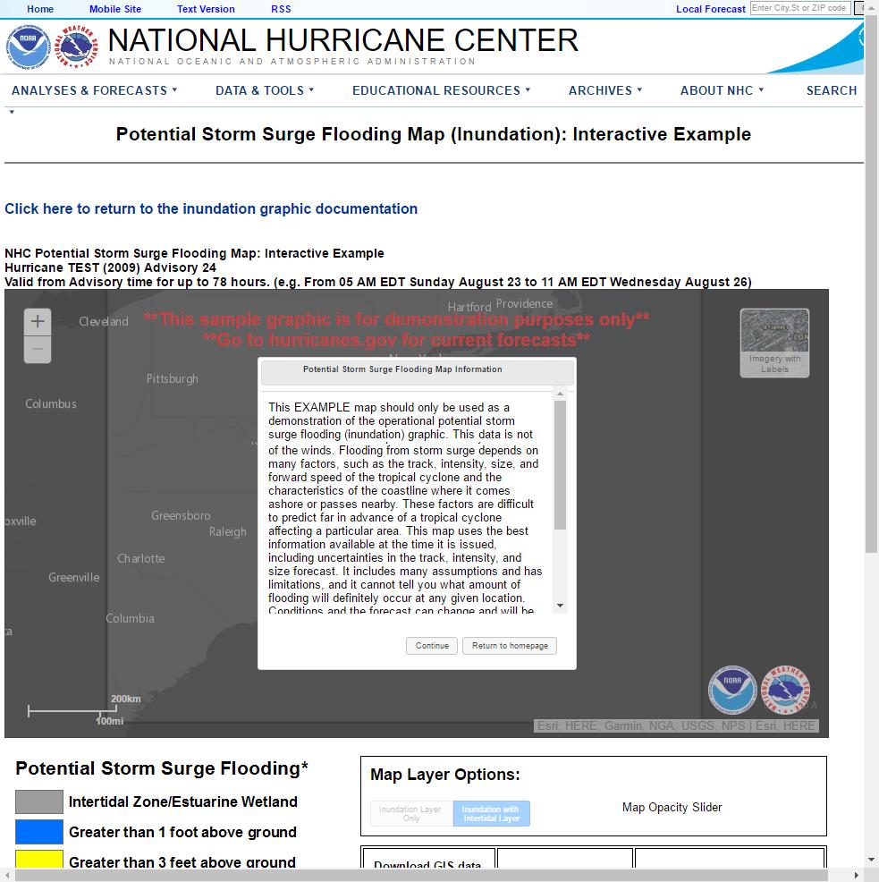
5 Preparation Collaboration with NWS and NHC Glynn County works closely with National Weather Service (NWS) and National Hurricane Center (NHC) in preparation for hurricane season. Mock hurricane tabletop exercises with Glynn County EMA, NWS JAX, and GEMA annually. NWS JAX provided advisories every 6 hours leading up to the storm. Software used HURREVAC - administered by FEMA, the USACE, and the NOAA National Hurricane Center. GCGIS utilized inundation data to determine where to relocate county assets and to determine an evacuation decision, mandatory, voluntary, or none. Software HURREVAC, ArcGIS for desktop , NHC GeoTIFF (inundation raster)
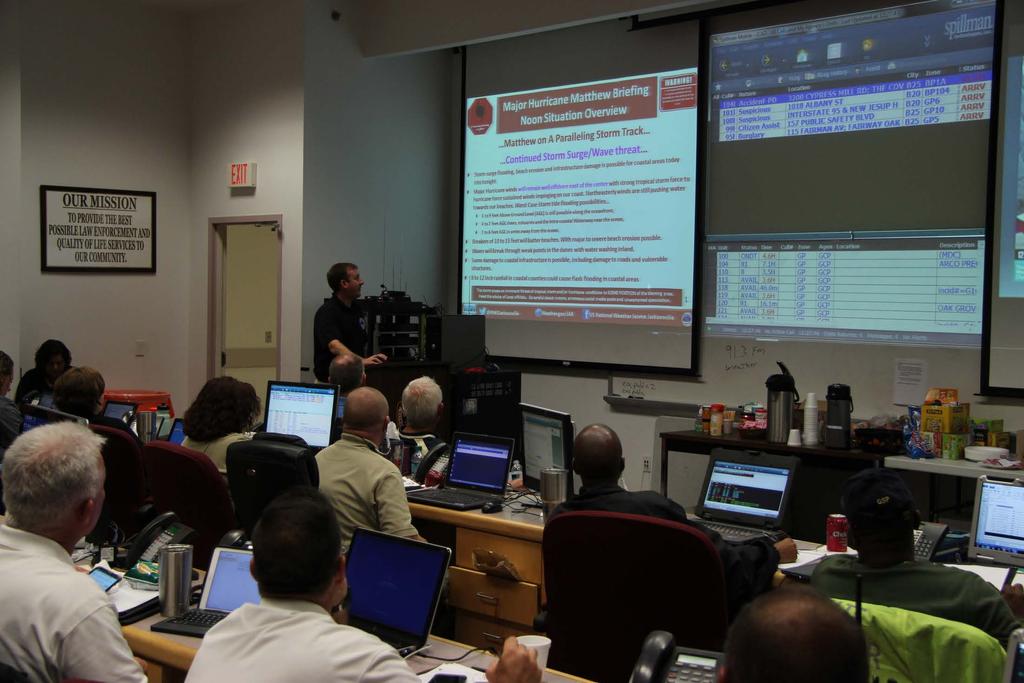
6 During the Storm Map Production Hurricane storm surge inundation For: Glynn County officials Purpose: To allow Glynn County Officials to determine the need to evacuate critical facilities such as the detention center. To identify areas of flooding where county assets and equipment may need to be moved. To identify which, if any, county facilities may receive flooding and plan strategies to allow access back into these locations after the storm. Data: Glynn county GIS maintained layers and GeoTIFF data from NHC. Software: ArcGIS for Desktop

7 ADVISORY 35 OCTOBER 7, 6:30 AM

8 ADVISORY 38 OCTOBER 7, 4:30 PM
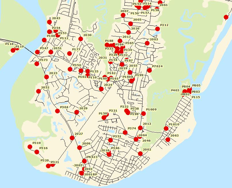
9 During the Storm Map production cont. Emergency Operating Sectors For: Glynn County Police Purpose: small 8.5x11 maps showing emergency operating sectors to be handed out to emergency personnel to show areas to patrol. Data: Glynn County GIS maintained layers. Software: ArcGIS for Desktop Glynn County Roads Map For: National Guard Purpose: To show Glynn County roads for the National Guard to navigate and clear roads of down trees and open access into subdivisions. Data: Glynn County GIS maintained layers Software: ArcGIS for Desktop

10
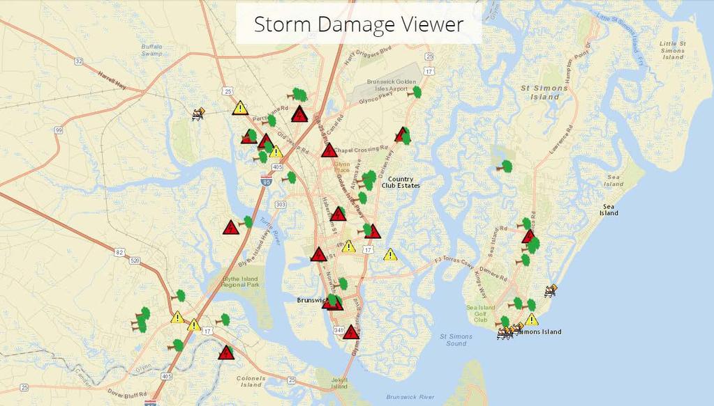
11 Website updates During the Storm Glynn County Storm Damage Viewer For: Glynn County officials and general public Purpose: GCGIS created an ArcGIS online map application to track road closures, down trees, down power lines, flooding, and other areas of concern during Hurricane Matthew. Data: ArcGIS Online Basemap, storm damage layers created for this viewer. Points - down trees, down power lines, closed roads, other areas of concern Area flooding Hurricanes active from ArcGIS Online hurricane tracks and positions provided by ESRI disaster response, NOAA National Hurricane Center (NHC) and Joint Typhoon Warning Center (JWTC) Software: ArcGIS for Desktop and ArcGIS Online
12
13 During the Storm Collaboration with NWS and NHC Glynn County Emergency Operations Center (EOC) received weather advisory briefings during the storm event from NWS meteorologist Ben Nelson on location and meteorologist Al Sandrik remote (JAX) on storm intensity, location, and tracks every 3 hours during the storm event. These briefings allowed Glynn county officials to monitor storm activity and possible scenarios for storm impact to make decisions regarding county assets, personnel, reentry, and damage assessment. Software: HURREVAC During the storm event after each advisory the NHC provided a potential storm surge inundation GeoTIFF for download and use in GIS software. GCGIS overlaid the GeoTIFF datasets in local County maps to allow county officials to make decisions about County facilities, asset locations, and potential areas of impact. Software: ArcGIS for Desktop Data: Glynn County GIS maintained layers and NHC storm surge GeoTIFF
14
15
16
17 After the Storm Brunswick Glynn Joint Water and Sewer Commission (JWSC) JWSC determined that at 7:00 PM on Sunday October, 9th (more than 40 hours after the hurricane had passed) that more than 80% of the sewer system was nonoperational on St. Simons Island and it was unsafe for residents to return. GCGIS used a projector and ArcGIS Desktop (inside the EOC) to map the water and sewer utilities as they became operational. Existing utility data was presented in a way that all agencies and elected officials could make timely decisions to ensure citizen safety.
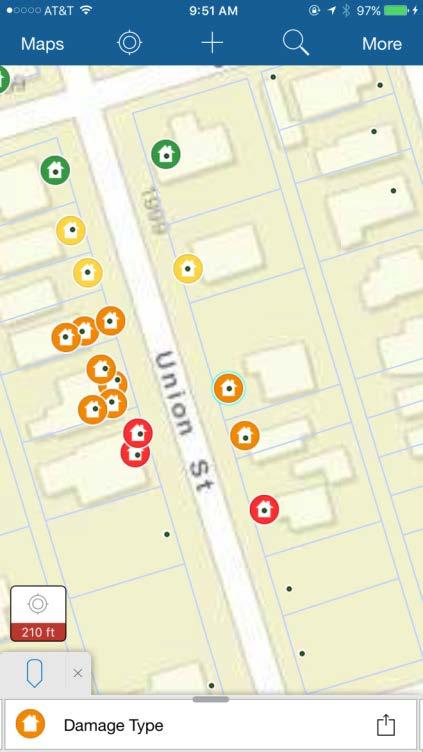
18
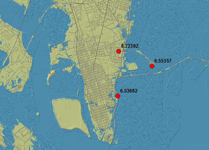
19 After the Storm High water marks GCGIS collected high water marks from known flooded areas, particularly along the eastern part of the County and St. Simons Island. High water marks are marks on houses or debris lines on the ground left by the surge. These high water marks were collected with survey grade GPS in order document the elevation of the storm surge. Equipment: Leica Viva GS 15 antenna and CS 15 controller Software: Leica SmartWorx Viva, Leica Geo Office, ArcGIS for Desktop Data: Glynn County GIS maintained layers, high water points collected by GCGIS
20 Validation of NHC forecast data After the Storm GCGIS used the high water mark data to establish an overall storm surge elevation during Hurricane Matthew. The elevation of the high water marks were approximately 6.7ft. above mean sea level. Mean Sea Level for Glynn County is approx. 3-4 ft. in elevation. The predicted high tide for Saturday October 8 th at 2:18am should have been 6.8ft. This would indicate a storm tide of approx. 11ft. or 3 ft. storm surge plus wave action. Using DEM data GCGIS was able to symbolize the storm surge inundation. Comparing the High Water Marks and DEM data with the potential storm surge inundation GeoTIFF from the NHC advisory just before the storm passed, it was determined that these predictions were a near match to actual storm surge levels. Software: ArcGIS for desktop Data: Glynn county GIS maintained layers, Glynn county 2008 LIDAR DEM, GCGIS collected high water marks, NHC potential storm surge inundation GeoTIFF
21
22 After the Storm FRI 8:08 PM 1.7 FEET LOW TIDE SAT 2:18 AM 6.8 FEET HIGH TIDE
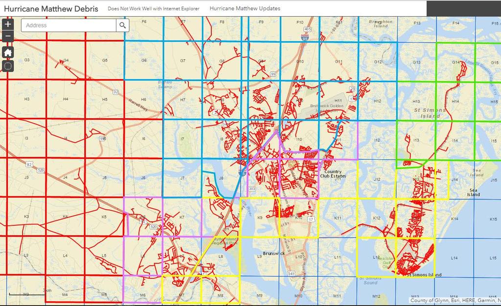
23 After the Storm Debris removal GCGIS created debris removal area maps that had the dates the debris would be picked up in specific locations of the County. Software: ArcGIS for Desktop Created a debris removal area viewer allowing residents to search their address and observe which debris removal area they reside in. Software: ArcGIS for Desktop ArcGIS Online App Builder
24
25 After the Storm Preliminary Damage Assessment During the preliminary damage assessment, GCGIS, assisted in the data collection in the field. FEMA field sheets Produced location maps of reported and expected heavily damaged areas to aid in the effort and expedite data collection. Maps created with points indicating homes that had damage and were included in the FEMA damage assessment. FEMA later used these maps to survey/sample damage assessment properties. Software: ArcGIS for Desktop

26 Preliminary Damage Assessment I.A. Individual Assistance P.A. Public Assistance

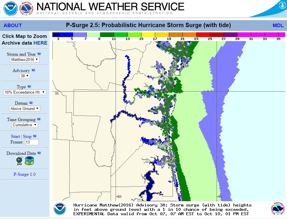
27 What is FEMA looking for? Extent of Damage Minor, Major, Destroyed Dwelling Type Low income Insured Primary Residence

28 Know your Assessment Areas Identify areas prone to flooding Identify areas with vulnerable populations

29 After the Storm

30 SURVEY 123 NEW FROM ESRI
31 Lessons learned Brunswick-Glynn Joint Water and Sewer Commission It would have been beneficial for JWSC GIS personnel to be present at the EOC or a Water and Sewer Utilities Map Viewer would have been an asset during the event. Storm Damage Viewer The major problem that Glynn County GIS encountered was removing features from the map once the hazard had been addressed by an agency. It was difficult for Public Works and the 911 Center to determine which hazards had been mitigated in real time. Preliminary Damage Assessment It would have been helpful for Customer Service and 911 to have provided a list of addresses with damage not necessarily concerning the roadways. GCGIS may have used these addresses as a starting point for the PDA.

 Detailed road maps should have been created in advance or")
32 Lessons learned Wireless Internet and Portable Database Jetpack (Mobile Hotspot) and External Hard Drives with GIS Database included where extremely beneficial as our home office lost power. Local Road Maps GCGIS had difficulty providing road maps timely and efficiently to outside agencies. (Our printer could only print up to 11 x 17 size) Detailed road maps should have been created in advance or Chamber of Commerce brochure road maps stocked.
33 Lessons learned Hurricane Damage Viewer: 15e08c871e212 Inundation Advisory/DEM Comparison Swipe Map: b0409f7d344f0b16 Debris Collection Viewer: a31472aea54d98
34 Lessons learned National Hurricane Center Potential Storm Surge Flooding: National Weather Service Probabilistic Hurricane Surge: y23&d=agl&ti=cum&msg=13&help=about Contact Information
A HURRICANE IS COMING. Presented by Atiba Upchurch Broward Emergency Management Division
 A HURRICANE IS COMING Presented by Atiba Upchurch Broward Emergency Management Division Mission Statement To safeguard the lives and property of the people of Broward County from major hazards and emergencies
Hurricane Readiness for Coastal Communities
 Hurricane Readiness for Participant Guide Developed for: Federal Emergency Management Agency Emergency Management Institute 16825 South Seton Avenue Emmitsburg, MD 21727-8998 Developed by: C² Technologies,
Hurricane Matthew. Life Threatening Flash Flooding Likely. National Weather Service Wilmington NC. Josh Weiss, Meteorologist
 Hurricane Matthew Life Threatening Flash Flooding Likely Threat Assessment for northeast South Carolina & southeast North Carolina National Weather Service Wilmington NC 630 PM EDT Friday October 7, 2016
Hurricane Matthew Life Threatening Flash Flooding Likely
 Hurricane Matthew Life Threatening Flash Flooding Likely Threat Assessment for northeast South Carolina & southeast North Carolina National Weather Service Wilmington NC 12 AM EDT Saturday October 8, 2016
Hurricane Matthew. National Weather Service Wilmington NC. Steven Pfaff, WCM.
 Hurricane Matthew Threat Assessment for northeast South Carolina & southeast North Carolina National Weather Service Wilmington NC 730 AM EDT Tuesday October 4, 2016 Steven Pfaff, WCM Steven.Pfaff@noaa.gov
Saturday, November 17, :30 a.m. EST
 Saturday, November 17, 2018 8:30 a.m. EST Significant Activity Nov 16-17 Significant Events: CA Wildfires Tropical Activity: Atlantic No new tropical cyclones are expected during the next 5 days Eastern
Table-Top Exercise for Emergency Preparedness Evaluation: Little Anse, Isle Madame
 Table-Top Exercise for Emergency Preparedness Evaluation: Little Anse, Isle Madame Alexander Chung, M.Sc. Candidate C-Change Student Research Associate May 2013 The Community of Little Anse Coastal community
TXWARN Tabletop Exercise: Hurricane Helen
 TXWARN Tabletop Exercise: Hurricane Helen July 31, 2015 Administrative Details In-studio participants and remote participants Situation manual Evaluations Training hours 1 In Studio: Welcome and Introductions
IH 35 at Blanco River May 2015
 IH 35 at Blanco River May 2015 Presentation Objectives Background of historical damage assessment processes Introduction to Collector App ( Mat Peck) Collector App and Flood Damage Assessment (Katie Steele)
Superstorm Sandy What Risk Managers and Underwriters Learned
 Superstorm Sandy What Risk Managers and Underwriters Learned Gary Ladman Vice President, Property Underwriting AEGIS Insurance Services, Inc. Superstorm Sandy Change in the Weather Recent years appears
Hurricane Matthew Threats and Impacts Briefing for Eastern NC
 Hurricane Matthew Threats and Impacts Briefing for Eastern NC October 6 th, 2016 Date/Time Created: 10/6/2016, Noon EDT National Weather Service Newport/Morehead City, NC Hurricane Matthew Key Points Changes
WHAT HAPPENS WHEN A TORNADO STRIKES THE COMMUNITY? Carroll County Sheriff s Office Emergency Management
 WHAT HAPPENS WHEN A TORNADO STRIKES THE COMMUNITY? Carroll County Sheriff s Office Emergency Management WHAT IS EMERGENCY MANAGEMENT? Carroll County Sheriff s Office Emergency Management Agency is responsible
United States Multi-Hazard Early Warning System
 United States Multi-Hazard Early Warning System Saving Lives Through Partnership Lynn Maximuk National Weather Service Director, Central Region Kansas City, Missouri America s s Weather Enterprise: Protecting
Daily Operations Briefing. Thursday, October 26, :30 a.m. EDT
 Daily Operations Briefing Thursday, October 26, 2017 8:30 a.m. EDT Significant Activity Oct 25-26 Significant Events: Response and recovery Tropical Cyclones Harvey, Irma and Maria Tropical Activity: Atlantic
Miami-Dade County Overview
 Miami-Dade County Overview 2,000 square miles World s busiest cruise port 2.6 million residents Second busiest US airport for international travelers Gateway to the Caribbean and Latin America Natural
Monday, November 19, :30 a.m. EST
 Monday, November 19, 2018 8:30 a.m. EST Significant Activity Nov 16-19 Significant Events: CA Wildfires Tropical Activity: Atlantic No new tropical cyclones are expected during the next 5 days Eastern
Daily Operations Briefing. Wednesday, August 23, :30 a.m. EDT
 Daily Operations Briefing Wednesday, August 23, 2017 8:30 a.m. EDT Significant Activity August 22-23 Significant Events: Tropical Weather Threat Gulf Coast Tropical Activity: Atlantic Disturbance 1 High
Daily Operations Briefing. Sunday, October 5, :30 a.m. EDT
 Daily Operations Briefing Sunday, October 5, 2014 8:30 a.m. EDT Significant Activity: Oct 4-5 Significant Events: Typhoon 19W (Vongfong) Tropical Activity: Atlantic Tropical Cyclone Activity is not expected
Storm Surge Forecast with Shifting Forecast Tracks
 Storm Surge Forecast with Shifting Forecast Tracks Storm Surge Findings in the Florida Keys Jon Rizzo Warning Coordination Meteorologist National Weather Service Florida Keys Florida Keys Life History
National Situation Report As of 3:00 a.m. EDT, Thursday, September 21, 2017 Table of Contents Current Operations Monitoring Recovery
 25k Overview National Situation Report As of 3:00 a.m. EDT, Thursday, September 21, 2017 Table of Contents Current Operations Monitoring Recovery FEMA Headquarters Status FEMA Region Status NRCC Level
Climate Risk Visualization for Adaptation Planning and Emergency Response
 Climate Risk Visualization for Adaptation Planning and Emergency Response NCR Flood Fact Finding Workshop Ricardo Saavedra ricardo@vizonomy.com Social Media, Mobile, and Big Data St. Peter s Basilica,
CATEX Hurricane Zachary
 CATEX Hurricane Zachary EXERCISE, EXERCISE,EXERCISE East Coast CATEX Power Restoration Functional Exercise 2013 This document was prepared under a grant from FEMA's Grants Programs Directorate, U.S. Department
Daily Operations Briefing. Thursday, November 9, :30 a.m. EST
 Daily Operations Briefing Thursday, November 9, 2017 8:30 a.m. EST Significant Activity Nov 8-9 Significant Events: Tropical Cyclones Harvey, Irma, and Maria Tropical Activity: Atlantic Tropical Storm
Daily Operations Briefing Saturday, October 1, :30 a.m. EDT
 Daily Operations Briefing Saturday, October 1, 2016 8:30 a.m. EDT Significant Activity Sept 30-Oct 1 Significant Events: None Tropical Activity: Atlantic Hurricane Matthew (CAT4); Disturbance 1 Low (10%)
Daily Operations Briefing. Wednesday, December 20, :30 a.m. EST
 Daily Operations Briefing Wednesday, December 20, 2017 8:30 a.m. EST Significant Activity Dec 19-20 Significant Events: Wildfires southern California Tropical Activity: Western Pacific No activity affecting
Lessons Learned and Shared
 Lessons Learned and Shared Plan for the worst. Hope for the best. Remember that hope is not a strategy. Agnes 8 Lessons 1. Identify Susceptible Communities 2. Develop a Plan 3. Threat Recognition 4. Review
Daily Operations Briefing. Saturday, May 13, :30 a.m. EDT
 Daily Operations Briefing Saturday, May 13, 2017 8:30 a.m. EDT Significant Activity May 12-13 Significant Events: None Significant Weather: Flash Flooding possible Northern NJ and New York City Fire Weather:
Daily Operations Briefing. Friday, November 10, :30 a.m. EST
 Daily Operations Briefing Friday, November 10, 2017 8:30 a.m. EST Significant Activity Nov 9-10 Significant Events: None Tropical Activity: Atlantic No tropical cyclones expected next 48 hours Eastern
Summary of Available Datasets that are Relevant to Flood Risk Characterization
 Inter-Agency Characterization Workshop February 25-27, 2014 USACE Institute for Water Resources, Alexandria, VA, IWR Classroom Summary of Available Datasets that are Relevant to Characterization National
Thursday, May 17, :30 a.m. EDT
 Thursday, May 17, 2018 8:30 a.m. EDT Significant Activity May 16-17 Significant Events: Kīlauea Volcano eruption Tropical Activity: Western Pacific no activity affecting U.S. interests Significant Weather:
Floodplain Mapping & Flood Warning Applications in North Carolina
 Floodplain Mapping & Flood Warning Applications in North Carolina Marc Stanard, IT Project Manager Ken Ashe, Assistant Director David Herlong, Flood Warning Program Manager NC Crime Control & Public Safety
HVX-HURREVAC (Beta) Webinar Series
 Webinar Series") HVX-HURREVAC (Beta) Webinar Series Day 1 - An introduction to HURREVAC and the new web-based HVX platform 2018 HVX-HURREVAC Webinar Series 1. Intro to HURREVAC and General Overview of the Program (August
HVX-HURREVAC (Beta) Webinar Series Day 1 - An introduction to HURREVAC and the new web-based HVX platform 2018 HVX-HURREVAC Webinar Series 1. Intro to HURREVAC and General Overview of the Program (August
Application of Geospatial Technology in an Emergency Management Academic Program
 Application of Geospatial Technology in an Emergency Management Academic Program Author Edwin Leachman Visiting Assistant Professor Department of Emergency Administration and Management Arkansas Tech University
Saturday, May 12, :30 a.m. EDT
 Saturday, May 12, 2018 8:30 a.m. EDT Significant Activity May 11-12 Significant Events: Kīlauea eruption Tropical Activity: Eastern Pacific Post-Tropical Cyclone One-E - FINAL Western Pacific Tropical
Major Hurricane Earl
 Major Hurricane Earl Advisory 32 North Carolina Threat Assessment Prepared at: 8 AM Thursday September 2, 2010 Hurricane and Tropical Storm Warnings in effect for the North Carolina Coast and Sounds. NWS
Sunday, November 25, :30 a.m. EST
 Sunday, November 25, 2018 8:30 a.m. EST Significant Activity Nov 24-25 Significant Events: CA Wildfires Tropical Activity: Atlantic Disturbance 1: Low (near 0%) Eastern Pacific Disturbance 1: Low (near
National Hurricane Program. FEMA Region IV
 National Hurricane Program FEMA Region IV Percent NHP A quick background Hurricane Program major buckets (Toolboxes) Hurricane Evacuation Study HURREVAC Post Storm Assessments Training Hurricane Liaison
Daily Operations Briefing. Wednesday, November 8, :30 a.m. EST
 Daily Operations Briefing Wednesday, November 8, 2017 8:30 a.m. EST Significant Activity Nov 7-8 Significant Events: Tropical Cyclones Harvey, Irma, and Maria Tropical Activity: Atlantic Tropical Storm
Coordinated Safety Messaging: An Integrated Approach. Matt Moreland FLGHC: Effective Messaging and Decision Support Services May 16, 2017
 Coordinated Safety Messaging: An Integrated Approach Matt Moreland FLGHC: Effective Messaging and Decision Support Services May 16, 2017 Question According to most meteorologists, how long should a weather
Fort Lauderdale s GIS Supports Response to. Hurricane Irma
 Fort Lauderdale s GIS Supports Response to Hurricane Irma By Monica Pratt, ArcUser Editor When Hurricane Irma first made landfall in the Florida Keys on September 10, 2017, it brought destructive 70 mph
Saturday, September 1, :30 a.m. EDT
 Saturday, September 1, 2018 8:30 a.m. EDT Significant Activity Aug 31 Sep 1 Significant Events: None Tropical Activity: Atlantic Tropical Storm Florence; Disturbance 1: Medium (40%) Eastern Pacific Hurricane
2014 Annual Mitigation Plan Review Meeting
 2014 Annual Mitigation Plan Review Meeting Highland County EMA MEETING OBJECTIVES Understand Your Natural Disaster Risk Review of Previous Plans Current Plan Status Future Activity Plan/Needs of Each Community
Tropical Update. 12 PM EDT Friday, October 7, 2016 Hurricane Matthew & Tropical Storm Nicole
 Tropical Update 12 PM EDT Friday, October 7, 2016 Hurricane Matthew & Tropical Storm Nicole This update is intended for government and emergency response officials, and is provided for informational and
NWS HURRICANES June 3, 2015
 NWS HURRICANES June 3, 2015 Hurricane Season June 1 November 30 2 What s the concern? All tropical systems passing within 125nm of central Maryland since 1950 Mid-Atlantic Hurricanes Greatest Risk: August
Daily Operations Briefing Friday, November 11, :30 a.m. EST
 Daily Operations Briefing Friday, November 11, 2016 8:30 a.m. EST Significant Activity Nov 10-11 Significant Events: None Tropical Activity: Atlantic Tropical cyclone activity is not expected during the
Daily Operations Briefing. Monday, October 9, :30 a.m. EDT
 Daily Operations Briefing Monday, October 9, 2017 8:30 a.m. EDT Significant Activity Oct 8-9 Significant Events: Response for Hurricane Maria Tropical Activity: Atlantic Tropical Depression Seventeen Eastern
Daily Operations Briefing. Sunday, March 4, :30 a.m. EST
 Daily Operations Briefing Sunday, March 4, 2018 8:30 a.m. EST Significant Activity Mar 3-4 Significant Events: Northeast coastal storm Tropical Activity: Western Pacific No activity affecting U.S. interests
Wednesday, May 23, :30 a.m. EDT
 Wednesday, May 23, 2018 8:30 a.m. EDT Significant Activity May 22-23 Significant Events: Kīlauea Volcano eruption Tropical Activity: Atlantic Invest 90L MEDIUM chance (60%) Significant Weather: Severe
Thursday, March 7, :30 a.m. EST
 Thursday, March 7, 2019 8:30 a.m. EST Significant Activity Mar 6-7 Significant Events: Severe thunderstorms and tornadoes AL and GA (FINAL) Tropical Activity: No activity affecting U.S. interests Significant
Daily Operations Briefing Sunday, July 24, :30 a.m. EDT
 Daily Operations Briefing Sunday, July 24, 2016 8:30 a.m. EDT Central Pacific Tropical Storm Darby http://www.prh.noaa.gov/cphc/ Tropical Storm Darby: (Advisory #51 as of 5:00 a.m. EDT) Located 145 miles
Daily Operations Briefing. Sunday, October 19, :30 a.m. EDT
 Daily Operations Briefing Sunday, October 19, 2014 8:30 a.m. EDT Significant Activity: Oct 18-19 Significant Events: Hurricane Ana Tropical Activity: Atlantic Hurricane Gonzalo (FINAL) Eastern Pacific
photo courtesy of
 BRITISH VIRGIN ISLANDS REPORT TROPICAL STORM JEANNE photo courtesy of www.bviplatinum.com PREPARED BY THE DEPARTMENT OF DISASTER MANAGEMENT 1 EVENT 13 th -16 th September, 2004 TROPICAL STORM JEANNE Sequence
Major Hurricane Matthew Briefing Situation Overview
 Major Hurricane Matthew Briefing Situation Overview At 5 p.m. Tuesday, Category 4 Hurricane Matthew was about 860 miles South-Southeast of Mayport, Florida, moving north around 10 mph. Maximum sustained
Frank Revitte National Weather Service. Weather Forecast Office New Orleans/Baton Rouge
 Frank Revitte National Weather Service Weather Forecast Office New Orleans/Baton Rouge Above normal activity 17 Total Named Storms 7 Tropical Storms 4 Hurricanes 6 Major Hurricanes Not the most active,
Business Preparedness. Hurricane Preparedness 2018 NFP InForum February 15, 2018
 Business Preparedness Hurricane Preparedness 2018 NFP InForum February 15, 2018 Agenda Past Experience Hugo Floyd Matthew Irma Hurricane Tabletop Exercise Pre-Landfall Post-Landfall (1 day and 10 days)
Friday, May 4, :30 a.m. EDT
 Friday, May 4, 2018 8:30 a.m. EDT Significant Activity May 3-4 Significant Events: No significant activity Tropical Activity: No significant activity Significant Weather: Enhanced Risk for severe thunderstorms,
Daily Operations Briefing Friday, January 20, :30 a.m. EST
 Daily Operations Briefing Friday, January 20, 2017 8:30 a.m. EST Significant Activity Jan 19-20 Significant Events: 58 th Presidential Inauguration Significant Weather: Flash flooding possible California,
Daily Operations Briefing. Friday, September 19, :30 a.m. EDT
 Daily Operations Briefing Friday, September 19, 2014 8:30 a.m. EDT Significant Activity: Sep 19 20 Significant Events: CA & OR Wildfires Southwest flooding (FINAL) Tropical Activity: Atlantic Tropical
Friday, September 28, :30 a.m. EDT
 Friday, September 28, 2018 8:30 a.m. EDT Significant Activity Sep 26-27 Significant Events: Hurricane Florence Response / Recovery Tropical Activity: Atlantic Tropical Storm Kirk; Disturbance 1: High (90%)
Daily Operations Briefing. Monday, October 30, :30 a.m. EDT
 Daily Operations Briefing Monday, October 30, 2017 8:30 a.m. EDT Significant Activity Oct 28-30 Significant Events: Response and Recovery Tropical Cyclones Harvey, Irma, and Maria Severe Weather Northeast
Daily Operations Briefing. Sunday, September 24, :30 a.m. EDT
 Daily Operations Briefing Sunday, September 24, 2017 8:30 a.m. EDT Significant Activity Sep 23-24 Significant Events: Response for Hurricane Maria Tropical Activity: Atlantic Hurricane Maria (CAT 2); Hurricane
Sea level rise Web GIS Applications
 Florida International University FIU Digital Commons GIS Center GIS Center 2018 Sea level rise Web GIS Applications Zhaohui Fu GIS-RS Center, Florida International University, Fujen@fiu.edu Sheyla Santana
Significant Flooding Expected
 Significant Flooding Expected Decision Support Briefing #5 As of: 9:00 AM September 14, 2018 What Has Changed? Flash Flood Watch now in effect for part of area, will be expanded later today 9/14/2018 9:23
Michelle Burnett, RI State Floodplain Manager Jess Stimson, RI Floodplain Mapping Coordinator
 The Sandy-est Aftermath: A Rhode Island Perspective After Hurricane Sandy Michelle Burnett, RI State Floodplain Manager Jess Stimson, RI Floodplain Mapping Coordinator June 13, 2013 Rhode Island Background
Peterborough Distribution Inc Ashburnham Drive, PO Box 4125, Station Main Peterborough ON K9J 6Z5
 Peterborough Distribution Inc. 1867 Ashburnham Drive, PO Box 4125, Station Main Peterborough ON K9J 6Z5 November 15, 2017 Ontario Energy Board PO Box 2319 27 th Floor, 2300 Yonge St Toronto ON M4P 1E4
TRB First International Conference on Surface Transportation Resilience
 TRB First International Conference on Surface Transportation Resilience Applying the Sea-Level Scenario Sketch Planning Tool to Enhance the Resilience of Long-Range Transportation Plans: Lessons Learned
Thursday, November 22, :30 a.m. EST
 Thursday, November 22, 2018 8:30 a.m. EST Significant Activity Nov 21-22 Significant Events: CA Wildfires Tropical Activity: Atlantic No new tropical cyclones are expected during the next 5 days Eastern
Daily Operations Briefing. Friday, October 6, :30 a.m. EDT
 Daily Operations Briefing Friday, October 6, 2017 8:30 a.m. EDT Significant Activity Oct 5-6 Significant Events: Response for Hurricane Maria, Preparations for Tropical Storm Nate Tropical Activity: Atlantic
Daily Operations Briefing Wednesday, February 15, :30 a.m. EST
 Daily Operations Briefing Wednesday, February 15, 2017 8:30 a.m. EST Oroville Dam Spillway Erosion CA Situation Erosion on the main spillway is not expected to expand further upstream and approach the
Communications and Lessons Learned from
 Weather Forecast Office Charleston, SC Communications and Lessons Learned from Southeast and Caribbean and Climate Community of Practice - April, 2017 Public Information and Communications During Extremes
Wednesday, November 7, :30 a.m. EST
 Wednesday, November 7, 2018 8:30 a.m. EST Significant Activity Nov 6-7 Significant Events: Tropical Cyclone Yutu Recovery Tropical Activity: Atlantic No new tropical cyclones are expected during the next
Daily Operations Briefing. Wednesday, September 27, :30 a.m. EDT
 Daily Operations Briefing Wednesday, September 27, 2017 8:30 a.m. EDT Significant Activity Sep 26-27 Significant Events: Response for Hurricane Maria Tropical Activity: Atlantic Tropical Storm Maria; Hurricane
Daily Operations Briefing. Friday, May 5, :30 a.m. EDT
 Daily Operations Briefing Friday, May 5, 2017 8:30 a.m. EDT Significant Activity May 4-5 Significant Events: Flooding Southern/Central Plains Significant Weather: Flash flooding possible Mid-Atlantic through
The Wind Hazard: Messaging the Wind Threat & Corresponding Potential Impacts
 The Wind Hazard: Messaging the Wind Threat & Corresponding Potential Impacts Scott Spratt Warning Coordination Meteorologist NWS Melbourne, FL David Sharp Science & Operations Officer NWS Melbourne, FL
Winter Ready DC District of Columbia Public Service Commission
 Winter Ready DC District of Columbia Public Service Commission Presented by: Michael Poncia, Vice President, Customer Operations, Pepco Holdings October 26, 2017 Preparing our System Improving our system
Hurricanes. Environmental Geology Mr. Paul Lowrey. Stacey Singleton, Cassandra Combs, Dwight Stephenson, Matt Smithyman
 Environmental Geology Mr. Paul Lowrey Stacey Singleton, Cassandra Combs, Dwight Stephenson, Matt Smithyman Hurricanes EMPACTS Project, Spring 2017 Northwest Arkansas Community College, Bentonville, AR
Major Hurricane Earl
 Major Hurricane Earl Advisory 33 North Carolina Threat Assessment Prepared at: 11 AM Thursday September 2, 2010 Hurricane and Tropical Storm Warnings in effect for the North Carolina Coast and Sounds NWS
WINTER STORM Annex II
 WINTER STORM Annex II I. PURPOSE A. This annex has been prepared to ensure a coordinated response by state agencies to requests from local jurisdictions to reduce potential loss of life and to ensure essential
Wednesday, March 20, :30 a.m. EDT
 Wednesday, March 20, 2019 8:30 a.m. EDT Significant Activity Mar 19-20 Significant Events: Flooding Central U.S. Tropical Activity: No activity affecting U.S. interests Significant Weather: No significant
IMPLEMENTING GOVERNMENT-WIDE ENTERPRISE GIS; THE FEDERATED MODEL
 IMPLEMENTING GOVERNMENT-WIDE ENTERPRISE GIS; THE FEDERATED MODEL James E. Mitchell, Ph. D. IT GIS Manager Louisiana Department of Transportation and Development presented at the ESRI International Users
Daily Operations Briefing Monday, March 30, :30 a.m. EDT
 Daily Operations Briefing Monday, March 30, 2015 8:30 a.m. EDT Significant Activity: Mar 27 30 Significant Events: Pacific earthquakes; no tsunami Significant Weather: Snow Upper Great Lakes and Northern
Daily Operations Briefing Sunday, January 8, :30 a.m. EST
 Daily Operations Briefing Sunday, January 8, 2017 8:30 a.m. EST Significant Activity Jan 6-8 Significant Events: Heavy Precipitation forecast to impact CA and NV Significant Weather: Freezing rain Pacific
City of Punta Gorda Community Emergency Management Plan 2013
 City of Punta Gorda Community Emergency Management Plan 2013 Hurricane Andrew- August 24, 1992 Category 5 hurricane. The second-most-destructive hurricane in U.S. history. The first named storm of the
Wednesday, June 13, :30 a.m. EDT
 Wednesday, June 13, 2018 8:30 a.m. EDT Significant Activity June 12-13 Significant Events: None Tropical Activity: Atlantic Disturbance 1: Low (20%) Eastern Pacific Tropical Storm Bud; Disturbance 1: Low
Daily Operations Briefing. Saturday, September 6, :30 a.m. EDT
 Daily Operations Briefing Saturday, September 6, 2014 8:30 a.m. EDT Significant Activity: Sep 5-6 Significant Events: Severe Weather Outbreak MI & IL Bridge Fire, CA Tropical Activity: Atlantic Disturbance
Sunday, September 30, :30 a.m. EDT
 Sunday, September 30, 2018 8:30 a.m. EDT Significant Activity Sep 29-30 Significant Events: None Tropical Activity: Atlantic Tropical Storm Leslie Eastern Pacific Hurricane Rosa (CAT 1); Tropical Storm
Significant Coastal Storm Today through Thursday, 11/7-8. Weather Briefing
 Significant Coastal Storm Today through Thursday, 11/7-8 Weather Briefing Prepared 10:00 am EST Wednesday, November 7, 2012 Presented by Gary Conte, Warning Coordination Meteorologist NOAA s National Weather
GIS Monroe Geographic Information System March 14, 2018
 GIS Monroe Geographic Information System March 14, 2018 Goals Maintain Enterprise/County-wide geo-database Increase spatial accuracy of data Build and acquire more data layers Increase use of GIS; as another
Daily Operations Briefing Saturday, January 16, :30 a.m. EST
 Daily Operations Briefing Saturday, January 16, 2016 8:30 a.m. EST Significant Activity: Jan 15-16 Significant Events: None Significant Weather: Flooding Central and Southern US Nor'easter expected over
SITUATION REPORT. Hurricane Nate. Operational Period: October 8, to October 9,
 SITUATION REPORT Hurricane Nate Operational Period: October 8, 2017 0800 to October 9, 2017 0759 CURRENT SITUATION 2:00 p.m. Briefing Hurricane Nate WEATHER SUMMARY All watches and warnings discontinued.
Daily Operations Briefing. Thursday, July 13, :30 a.m. EDT
 Daily Operations Briefing Thursday, July 13, 2017 8:30 a.m. EDT Significant Activity July 12-13 Significant Events: None Tropical Activity: Atlantic No tropical cyclones expected next 48 hours Eastern
StormReady Supporter Application Form updated by NWS Chanhassen on April 7, Name of Applying Entity: Point of Contact: Title:
 NATIONAL WEATHER SERVICE 1733 Lake Drive West Chanhassen, Minnesota www.weather.gov/twincities www.stormready.noaa.gov 952-361-6671, todd.krause@noaa.gov StormReady Supporter Application Form updated by
Geospatial natural disaster management
 Geospatial natural disaster management disasters happen. are you ready? Natural disasters can strike almost anywhere at any time, with no regard to a municipality s financial resources. These extraordinarily
HURRICANE PREPAREDNESS GUIDE
 HURRICANE PREPAREDNESS GUIDE BE PREPARED! TABLE OF CONTENTS Basic Preparedness Tips... 3 Preparing Your Home... 4 What To Do... 5 Make a Hurricane Plan... 6 Important Information... 7 pacu.com 800.433.7228
Storm Surge/Coastal Inundation State of the Union. Jamie Rhome Storm Surge Team Lead NOAA/National Hurricane Center
 Storm Surge/Coastal Inundation State of the Union Jamie Rhome Storm Surge Team Lead NOAA/National Hurricane Center 2 Tampa: Cat 5 Scenario 3 4 The Stakes are High Combination of SLR and increasing coastal
Daily Operations Briefing. Tuesday, October 24, :30 a.m. EDT
 Daily Operations Briefing Tuesday, October 24, 2017 8:30 a.m. EDT Significant Activity Oct 23-24 Significant Events: Response and recovery Tropical Cyclones Harvey, Irma, Maria Tropical Activity: Atlantic
Wednesday, July 11, :30 a.m. EDT
 Wednesday, July 11, 2018 8:30 a.m. EDT Significant Activity July 10-11 Significant Events: None Tropical Activity: Atlantic Disturbance 1: Medium (50%); Hurricane Chris (CAT 2) Eastern Pacific Disturbance
Monday, November 5, :30 a.m. EST
 Monday, November 5, 2018 8:30 a.m. EST Significant Activity Nov 3-5 Significant Events: Tropical Cyclone Yutu Recovery Tropical Activity: Atlantic No new tropical cyclones are expected during the next
Daily Operations Briefing Friday, January 22, :30 a.m. EST
 Daily Operations Briefing Friday, January 22, 2016 8:30 a.m. EST Significant Activity: Jan 21-22 Significant Events: Winter Storm Eastern U.S. Significant Weather: Heavy snow possible Cascades and Sierras;
The Tampa Bay Catastrophic Plan Presentation to CFGIS Users Group FDOT District 5 Urban Offices - Orlando July 30, 2010
 The Tampa Bay Catastrophic Plan Presentation to CFGIS Users Group FDOT District 5 Urban Offices - Orlando July 30, 2010 Brady Smith Senior Planner Tampa Bay Regional Planning Council Introduction Recent