Regional Sediment Management
|
|
|
- Isabel Barnett
- 5 years ago
- Views:
Transcription


1 Regional Sediment Management Linda S. Lillycrop Program Manager Coastal Engineer US Army Engineer Research and Development Center Coastal and Hydraulics Laboratory Q AVG Coastal Resilience: The Environmental, Infrastructure, and Human Systems New Orleans, LA May 2014 Q AVG US Army Corps of Engineers BUILDING STRONG


2 Why RSM?

3 Regional Sediment Management A systems approach for efficient and effective use of sediments and management of projects in our Coastal, Estuarine, Riverine, and Watershed environments


4 RSM = Sustainable Solutions for.. Navigation/Dred ging Flood Risk Management Environmental Restoration RSM Operating Principles: Recognize sediments as a regional resource; prioritize use Link and leverage across multiple projects, business lines, authorities Improve operational efficiencies & natural exchange of sediments Economically viable, environmentally sustainable solutions Local sediment actions which benefit the region, consider regional impacts Enhance technical knowledge/tools for regional approaches Share information and data Communicate and collaborate USACE, Stakeholders, Partners


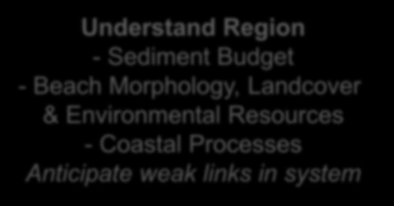
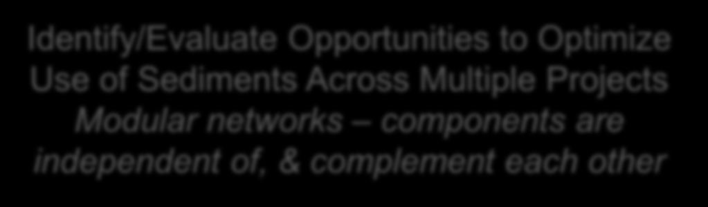
5 RSM Process Understand Region - Sediment Budget - Beach Morphology, Landcover & Environmental Resources - Coastal Processes Anticipate weak links in system Regional Budget RegionalSediment and Local Surveys Reduce Offshore Reduce/Utilize CDF Placement Sediments Identify Gaps/Improve Knowledge Data Management/Regional Tools Information accessible for decision-making Identify/Evaluate Opportunities to Optimize Use of Sediments Across Multiple Projects Modular networks components are independent of, & complement each other Take Action: Construct Pilot Projects Monitor: Evaluate Performance Incorporate Standard Practice Provide diverse and redundant protection Coastal Land Cover Landcover type Nearshore/Beac Optimize Placement h Bypassing Placement ID Monitor Opportunities Performance & Adaptive Evaluate Sediment Management Ecosystem Reduce Lake/Reservoir Restoration Implement Sedimentation Improvement
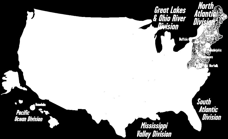


6 USACE RSM Participation ( ) CODS/CFDC NCDB MCNP WOTS
7 RSM and Resilience Successes

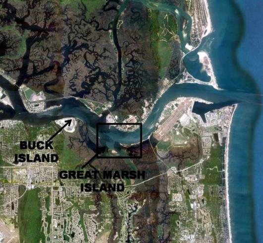


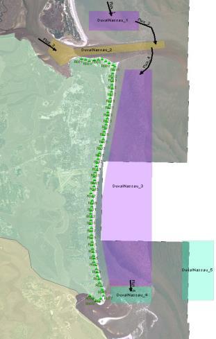
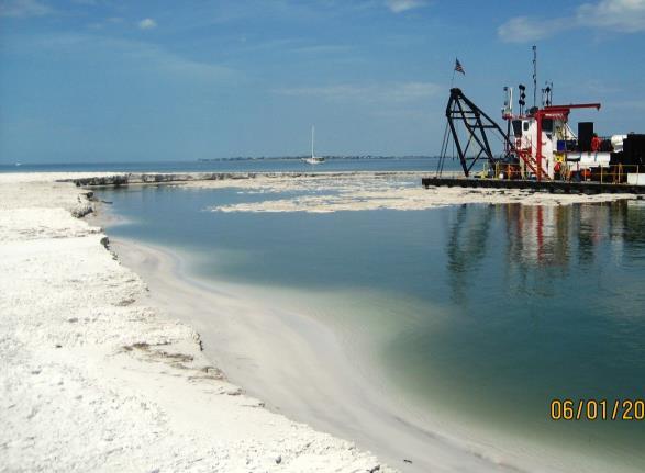
8 Jacksonville District - St Johns, Duval, Nassau Counties GRR Jacksonville Harbor Deepening Buck Island Great Marsh Island Nearshore Placement


9 Portland District - Mouth of the Columbia River, OR Collaboration 2002: District & Stakeholders - Leverage: Projects, Resources, Models, Tools, Data Collection - Long-term strategy - Construction Monitoring Benefits - 4 New nearshore BU sites - Reduced dredging costs - Protect navigation structures channel system - Stabilize Inlet morphology - Extend capital investments - Reduce shoreline erosion - Environmental habitat 1939 Benson Beach * * head of jetty in *

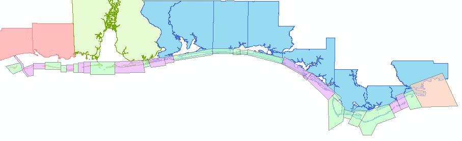
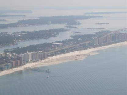
10 Mobile District RSM Domain 375-miles of Shoreline 21 Federal Projects 8 State Parks 7 Military Installations Gulf Islands National Seashore Harrison County Beach Fill Panama City Beach Fill Local Projects

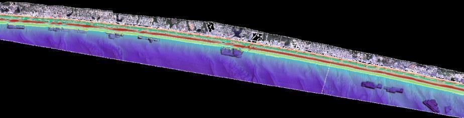

11 Mobile District RSM Demonstration


12 Regional to Local Opportunities Regional Sediment Management Domain Sub-Region 9 Sub-Region 7 Sub-Region 5 Sub-Region 3 Sub-Region 1 Mobile Bay Dauphin Island Sub-Region 8 Sub-Region 6 Sub-Region 4 Sub-Region 2 Perdido Pass Pensacola Pass East Pass Walton County Beaches Panama City Beaches Shell Island Port St Joe Mexico Beach Alligator Point Apalachicola Bay


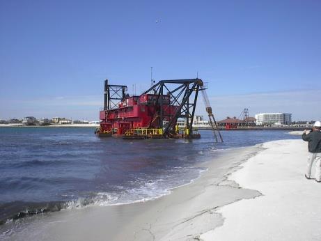
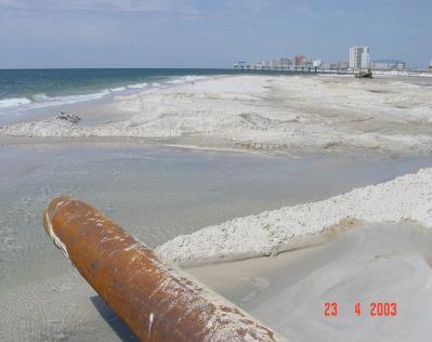
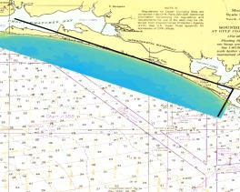
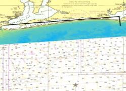
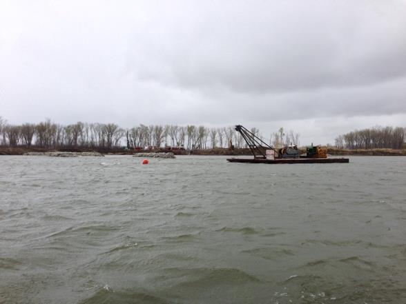
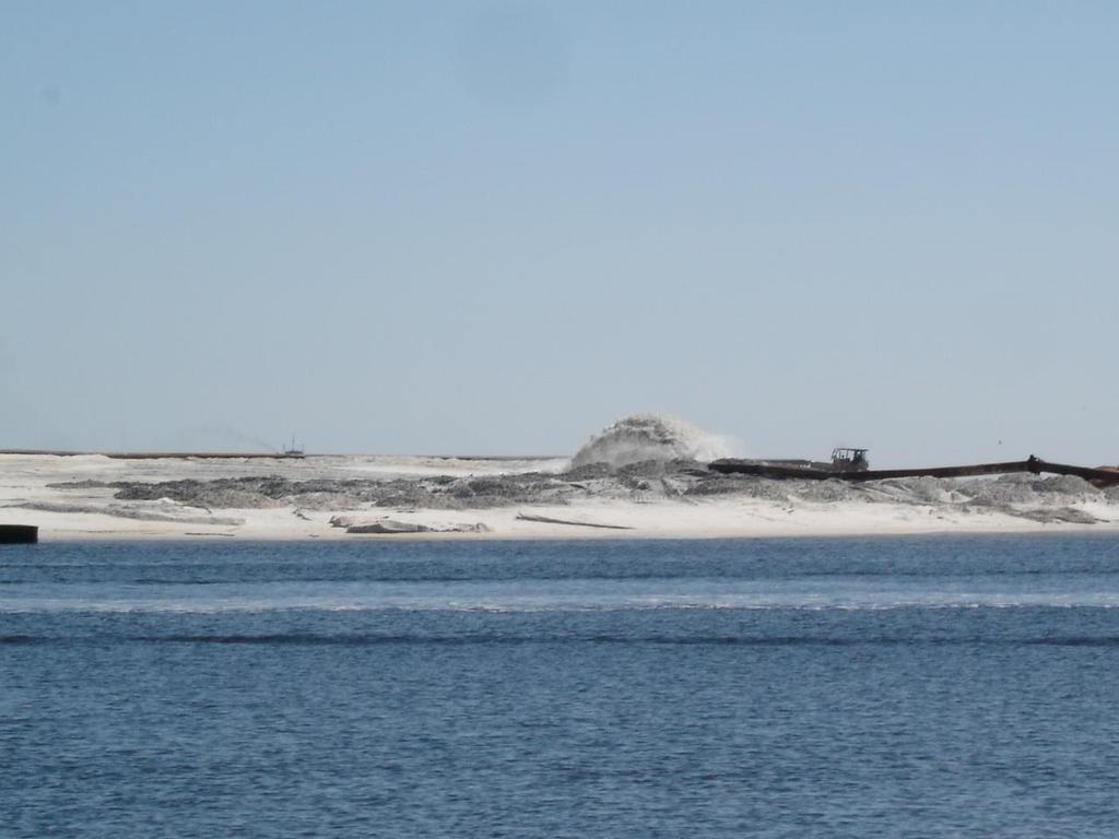
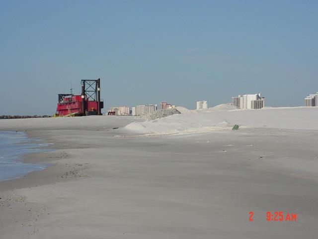
13 Perdido Pass, AL Pre-RSM Shoaling Area Placement Area Post-RSM mi

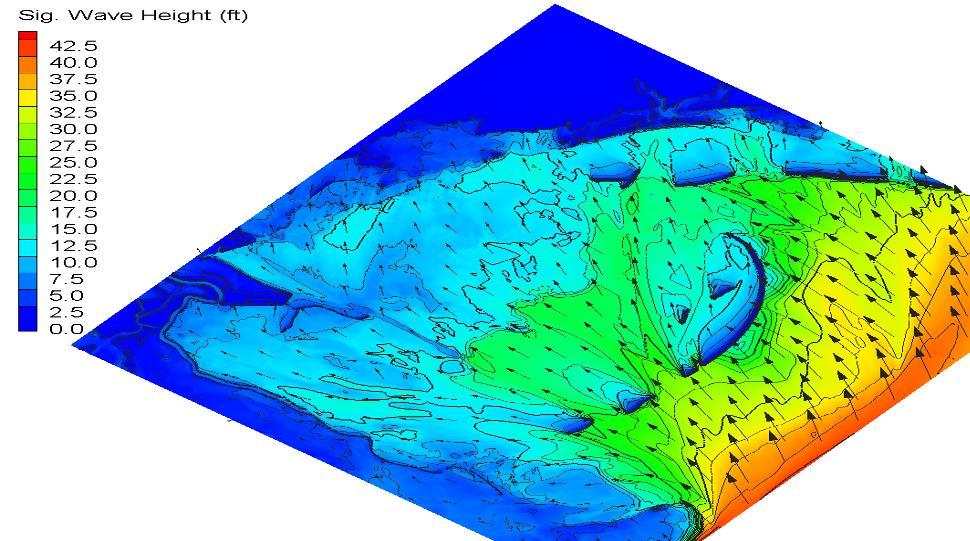
14 Hurricane Ivan 2004 Strong Cat mph winds + 14-foot surge

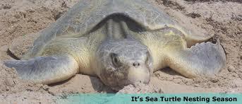
15 Pre-Ivan East side of Pass: Gulf State Park, Florida Point Natural beach system, Wide beaches Developed dune fields - 15-foot crest elevations above MSL Abundantly vegetated with sea oats and other native plants Habitat for several listed species Perdido Key beach mouse Piping plovers Least terns Nesting sea turtles.

16 Post-Ivan West side of Pass: infrastructure protected East side of Pass: X100,000s cubic yards of sand lost from beaches and dunes Eroded into Pass Overwashed into back-bay Transported seaward 5 to 10 feet of elevation lost Leveled dune fields Major beach erosion Much of the critical habitat destroyed
17 Post Ivan Recovery: Multi-agency effort to quickly develop & implement a restoration plan U.S. Fish and Wildlife Service Restoration of critical habitat Coordination for threatened and endangered species Critical habitats Alabama Dept. of Conservation and Natural Resources Use of state lands Alabama Dept. of Environmental Management Water Quality Certification / Coastal Zone Consistency Gulf State Parks Environmental coordination City of Orange Beach Easements and right of ways USACE Planning Engineering Operations

18


19 Post placement: 90 least tern nests 16 black skimmer nests 1 documented sea turtle nest Natural vegetation returning Perdido Pass Resilience Prepare: Regional/local Understanding Identify Opportunities Resist: RSM Sediment Optimization Recover: Partnerships, Coordination, Post Dredging/Placement Adapt: Florida Point Restoration

20 Why RSM is Important & supports resilience Improve utilization of sediments - local & regional Link multiple projects, authorities, leverage funding, reduce timelines Improve channel availability, shoreline erosion, environmental habitat Increase benefits while reducing/maintaining costs Share data, tools, and capabilities Improve partnerships and collaboration


")

21 RSM.USACE.ARMY.MIL RSM Technical Notes, Reports, Manuals, Conference Papers Tools and Data Sediment Budget Analysis System (SBAS) CE-Dredge-RSM Dredging Manager & Viewer Models and Databases Etc


22 14 th Annual RSM and EWN In-Progress-Review and Workshop July 2014 Vicksburg, MS 2013 RSM and EWN IPR and Workshop Coastal and Hydraulics Laboratory, Vicksburg
GALVESTON BAY RSM Moving toward an Integrated, Cooperative, and Holistic Approach to Estuarine Sediments
 GALVESTON BAY RSM Moving toward an Integrated, Cooperative, and Holistic Approach to Estuarine Sediments RAE Conference 2010 Larry A. Wise Moffatt & Nichol RSM is a system-based approach for collaboratively
ENGINEERING APPROACHES TO SHORELINE PLACEMENT FROM COAST TO COAST
 ENGINEERING APPROACHES TO SHORELINE PLACEMENT FROM COAST TO COAST 237 237 237 217 217 217 200 200 200 0 0 0 163 163 163 131 132 122 80 119 27 252 174.59 83 36 118 110 135 120 112 92 56 62 102 130 Comparing
MISSISSIPPI COASTAL IMPROVEMENTS
 MISSISSIPPI COASTAL IMPROVEMENTS PROGRAM (MsCIP) Comprehensive Barrier 237 27 200 237 27 200 Island 237 Restoration 27 200 Plan 80 9 27 252 74.59 255 255 255 0 0 0 63 63 63 3 32 22 239 65 53 0 35 20 2
Coastal Inlets Research Program US Army Corps of Engineers Engineering Research and Development Center
 Coastal Inlets Research Program US Army Corps of Engineers Engineering Research and Development Center Site of Moriches Inlet Nov. 1951 Julie Dean Rosati and Nicholas C. Kraus, CIRP Program Manager Shinnecock
Heather Schlosser Army Corps of Engineers Coastal Studies Group August 28, 2008
 Got sand? Regional Sediment Management in Orange County Heather Schlosser Army Corps of Engineers Coastal Studies Group August 28, 2008 Regional Sediment Management Regional sediment management recognizes
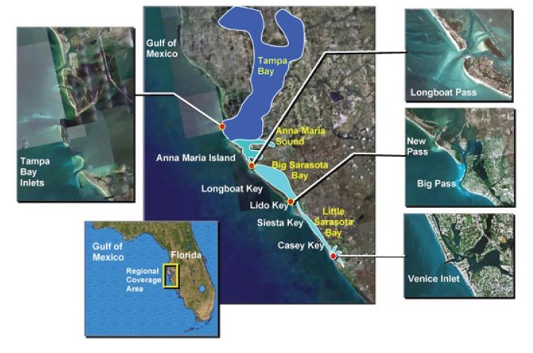
Pinellas, Manatee, and Sarasota Counties, Florida; Regional Sediment Budget
 Pinellas, Manatee, and Sarasota Counties, Florida; Regional Sediment Budget by Kelly R. Legault and Ashley E. Frey PURPOSE: This U.S. Army Corps of Engineers (USACE) Regional Sediment Management Technical
Material Workshop. Galveston District 2012 Beneficial Use of Dredged. Material Workshop. Custodians of the Coast
 Galveston District 2012 Beneficial Use of Dredged Material Workshop Galveston District 2012 Beneficial Use of Dredged Material Workshop US Army Corps of Engineers BUILDING STRONG Welcome Opening Remarks
Coastal Barrier Island Network (CBIN): Management strategies for the future
: Management strategies for the future") Coastal Barrier Island Network (CBIN): Management strategies for the future Heather Joesting*, Amy Williams**, Rusty Feagin**, and William K. Smith* *Department of Biology, Wake Forest University, Winston
Coastal Barrier Island Network (CBIN): Management strategies for the future Heather Joesting*, Amy Williams**, Rusty Feagin**, and William K. Smith* *Department of Biology, Wake Forest University, Winston
EAGLES NEST AND PIASA ISLANDS
 EAGLES NEST AND PIASA ISLANDS HABITAT REHABILITATION AND ENHANCEMENT PROJECT MADISON AND JERSEY COUNTIES, ILLINOIS ENVIRONMENTAL MANAGEMENT PROGRAM ST. LOUIS DISTRICT FACT SHEET I. LOCATION The proposed
MODELING OF EROSION CONTROL ALTERNATIVES AT STUMP PASS, CHARLOTTE COUNTY
 2014 NATIONAL CONFERENCE ON BEACH PRESERVATION TECHNOLOGY FEBRUARY 13, 2014 MODELING OF EROSION CONTROL ALTERNATIVES AT STUMP PASS, CHARLOTTE COUNTY 1 VADIM ALYMOV, PH.D. 2 CHUCK MOPPS 3 MICHAEL POFF,
Engineering with Nature: Nearshore Berm Placements at Fort Myers Beach and Perdido Key, Florida, USA
 Engineering with Nature: Nearshore Berm Placements at Fort Myers Beach and Perdido Key, Florida, USA Katherine E. Brutsché, Ph.D. Research Physical Scientist ERDC-Coastal & Hydraulics Laboratory May 14,
ENGINEERING WITH NATURE: NEARSHORE BERM PLACEMENTS AT FORT MYERS BEACH AND PERDIDO KEY, FLORIDA, USA
 1 ENGINEERING WITH NATURE: NEARSHORE BERM PLACEMENTS AT FORT MYERS BEACH AND PERDIDO KEY, FLORIDA, USA KATHERINE E. BRUTSCHÉ 1, PING WANG 2, JULIE D. ROSATI 1, CHERYL E. POLLOCK 1 1. U.S. Army Engineer
Racing against time, an unprecedented year: the US Army Corps of Engineers (USACE) response to the hurricanes of 2004
 response to the hurricanes of 2004") Environmental Problems in Coastal Regions VI 205 Racing against time, an unprecedented year: the US Army Corps of Engineers (USACE) response to the hurricanes of 2004 R. I. McMillen 1, D. R. Haubner 2,
Environmental Problems in Coastal Regions VI 205 Racing against time, an unprecedented year: the US Army Corps of Engineers (USACE) response to the hurricanes of 2004 R. I. McMillen 1, D. R. Haubner 2,
Sediment Management in the Coastal Bays
 Sediment Management in the Coastal Bays Introduction Need for ecosystem view of sediment management in Coastal Bays Island loss and restoration Navigation needs Habitat Trade offs Living Shoreline Requirements
Earth Wind & Fire. Game Changing Restoration Options in the Texas Chenier Plain
 Earth Wind & Fire Game Changing Restoration Options in the Texas Chenier Plain EARTH: The Chenier Plain is a 5 million acre coastal region in Southwest Louisiana and Southeast Texas providing landscape
REGIONAL SEDIMENT MANAGEMENT IN THE CORPS OF ENGINEERS
 REGIONAL SEDIMENT MANAGEMENT IN THE CORPS OF ENGINEERS Julie D. Rosati 1, Lynn M. Bocamazo 2, Bruce D. Carlson 3, Jack E. Davis 1, Thomas D. Smith 4, Jennifer M. Wozencraft 5, Lynn Hardegree 5 ABSTRACT
Nearshore Placement as a Regional Sediment Management Practice
 Nearshore Placement as a Regional Sediment Management Practice Katherine E. Brutsché, Ph.D. Brian C. McFall, Ph.D., P.E. Coastal and Hydraulics Laboratory US Army Engineer R&D Center ASBPA National Coastal
EAST PASS UP-DATE SUMMARY OF FINDINGS REPORT and INLET MANAGEMENT IMPLEMENTATION PLAN
 EAST PASS 2013 UP-DATE SUMMARY OF FINDINGS REPORT and INLET MANAGEMENT IMPLEMENTATION PLAN Introduction On June 8, 2000, the Florida Department of Environmental Protection adopted the East Pass Inlet Management
Regional-scale understanding of the geologic character and sand resources of the Atlantic inner continental shelf, Maine to Virginia
 Regional-scale understanding of the geologic character and sand resources of the Atlantic inner continental shelf, Maine to Virginia Workshop on Dredging, Beach Nourishment and Bird Conservation Atlantic
Quantifying effects of oil on coastal dune vegetation. Thomas Miller and Elise Gornish Biological Science, Florida State University
 Quantifying effects of oil on coastal dune vegetation Thomas Miller and Elise Gornish Biological Science, Florida State University Natural History of Barrier Islands in the Northern Gulf Make up ~70% of
Application #: TEXT
 TOWN OF FORT MYERS BEACH 2008 PROPOSED COMPREHENSIVE PLAN AMENDMENTS Application #: 2008-13-TEXT Description: Modify the Coastal Management and Future Land Use Elements to reflect the state s new definition
Sunset Harbour / Huntington Harbour Maintenance Dredging and Waterline Installation Project. CMANC 21 January 2016
 Sunset Harbour / Huntington Harbour Maintenance Dredging and Waterline Installation Project CMANC 21 January 2016 County of Orange Footprint Huntington Harbour Operational and Dredging Cost Sharing Agreements
The Corps of Engineers National Regional Sediment Management Demonstration Program
 The Corps of Engineers National Regional Sediment Management Demonstration Program by Julie D. Rosati, Bruce D. Carlson, Jack E. Davis, and Thomas D. Smith PURPOSE. This Coastal and Hydraulics Engineering
Regional Sediment Management: The Long Island Coastal Planning Project
 Regional Sediment Management: The Long Island Coastal Planning Project Lynn M. Bocamazo Senior Coastal Engineer USACE-New York District 22 September 2009 US Army Corps of Engineers Outline Project Location
Port of Kalama, 2013 TEMCO Berth Maintenance Dredging and In-water Flow-Lane Placement Project
 2014 WEDA ENVIRONMENTAL EXCELLENCE AWARDS Category: Navigation Dredging Port of Kalama, 2013 TEMCO Berth Maintenance Dredging and In-water Flow-Lane Placement Project Port of Kalama, Washington 18 April
ERDC Update SAD Regional Management Board
 ERDC Update SAD Regional Management Board José E. Sanchez, P.E., SES Director, Coastal and Hydraulics Laboratory Engineer Research and Development Center 14FEB17 Overview of R&D Activities in AOR Cross
Bob Van Dolah. Marine Resources Research Institute South Carolina Department of Natural Resources
 Bob Van Dolah Marine Resources Research Institute South Carolina Department of Natural Resources Shoreline Change Will Occur! On our front beaches where it is not easy to retreat Shoreline Change Will
The U.S. Army Corps of Engineers Philadelphia District
 The U.S. Army Corps of Engineers Philadelphia District The Atlantic Coast of New Jersey Regional Sediment Budget 1986-2003 Cape May Point to Manasquan Inlet Final Report March 2006 The Atlantic Coast of
Alexandra Carvalho, Ph.D., GISP Kathy Fitzpatrick, P.E.
 Coastal Data Organization for Project Management and Coastal Planning Martin County, Florida Alexandra Carvalho, Ph.D., GISP Kathy Fitzpatrick, P.E. Outline County Coastal Programs Coastal Geodatabase
PRESENTATION TITLE. Regional Sediment Management Application of a Coastal Model at the St. Johns River Entrance BUILDING STRONG
 PRESENTATION TITLE Regional Sediment Management Application of a Coastal Model at the St. Johns River Entrance Steven Bratos Senior Coastal Engineer U.S. Army Corps of Engineers Jacksonville District February
Regional Sediment Management at East Rockaway Inlet, NY, Utilizing the USACE Coastal Modeling System
 Regional Sediment Management at East Rockaway Inlet, NY, Utilizing the USACE Coastal Modeling System by US Army Engineer District, New York PURPOSE: This Coastal and Hydraulics Engineering Technical Note
The Sediment Budget Calculator: A Webtool to Develop a Family of Viable Inlet and Adjacent Beach Sediment Budget Solutions
 The Sediment Budget Calculator: A Webtool to Develop a Family of Viable Inlet and Adjacent Beach Sediment Budget Solutions by Julie Dean Rosati, Charles A. Sumner, and Derek A. Wilson PURPOSE: This Coastal
RESULTS FROM THE TEXAS COASTAL SEDIMENT SOURCES: A GENERAL EVALUATION STUDY
 RESULTS FROM THE TEXAS COASTAL SEDIMENT SOURCES: A GENERAL EVALUATION STUDY JUAN MOYA KELSEY CALVEZ CRIS WEBER ANTHONY RISKO *KEVIN FRENZEL FREESE AND NICHOLS, INC. COASTAL AND WATERWAYS GROUP OBJECTIVES
ΛTKINS. Applications of Regional Sediment Management Concepts in Texas Estuarine Restoration Projects. Riparian Workshop Fort Worth, October 17, 2012
 Juan C Moya, PhD., PG Coastal Planning and Restoration Applications of Regional Sediment Management Concepts in Texas Estuarine Restoration Projects Riparian Workshop Fort Worth, October 17, 2012 West
The Coastal Field Data Collection Program (CFDC) Waves & Coastal Observations for the Corps and the Nation
 Waves & Coastal Observations for the Corps and the Nation") The Coastal Field Data Collection Program (CFDC) Waves & Coastal Observations for the Corps and the Nation Bill Birkemeier Program Manager William.Birkemeier@usace.army.mil 10 August 2010 US Army Corps
The Coastal Field Data Collection Program (CFDC) Waves & Coastal Observations for the Corps and the Nation Bill Birkemeier Program Manager William.Birkemeier@usace.army.mil 10 August 2010 US Army Corps
THIN-LAYER PLACEMENT OF DREDGE MATERIAL FOR MARSH NOURISHMENT, RESOTRATION, AND RESPONSE TO SEA LEVEL RISE
 THIN-LAYER PLACEMENT OF DREDGE MATERIAL FOR MARSH NOURISHMENT, RESOTRATION, AND RESPONSE TO SEA LEVEL RISE Case studies and lesson learned regarding thin-layer deposition projects in Delaware, New Jersey,
Planning for the Future of Humboldt Bay: Sea Level Rise, Sediment Management, Sand Spits and Salt Marshes. Joel Gerwein
 Planning for the Future of Humboldt Bay: Sea Level Rise, Sediment Management, Sand Spits and Salt Marshes Joel Gerwein Introduction to Humboldt Bay Setting Economy, community, and environment Sediment
Beach Nourishment on the Florida East Coast. Boca Raton
 Beach Nourishment on the Florida East Coast Past Future Boca Raton Erosion is the Main Reason for Beach Past - Erosion on the east coast was mainly caused by inlets created or modified for navigation Nourishment
The Impact of Hurricane Irma on the Coast of Florida
 The Impact of Hurricane Irma on the Coast of Florida Ralph Clark, Guy Weeks, Robert Wang, Mike Manausa & Peter Bacopoulos Division of Water Resource Management February 8, 2018 Overview: Hurricane Irma
HAWAII REGIONAL SEDIMENT MANAGEMENT
 HAWAII REGIONAL SEDIMENT MANAGEMENT KAUAI Workshop January 20, 2011 Kauai Veteran s Center Kihei, HI of Engineers, Honolulu District AGENDA 1300-1310 Welcome and Introductions Conger Conant 1310-1330 Regional
Hurricane Protection and Environmental Restoration
 November 16, 2010 Hurricane Protection and Environmental Restoration Presented by: Colonel (Ret.) Leonard Waterworth AGENDA How do we protect People/Environment/Economy 1900 Year Storm Hurricane Carla
5/25/2017. What is projected for Coastal texas? PROTECTING CRITICAL WATER INFRASTRUCTURE FROM SEA LEVEL RISE
 PROTECTING CRITICAL WATER INFRASTRUCTURE FROM SEA LEVEL RISE What is projected for Coastal texas? Mean Sea Level has risen 3 18 to 37 above Mean Sea Level 1800-1992 1992-2015 2030 2060 2100 Mean Sea Level
DESIGN ENGINEERING ANALYSIS FOR TERMINAL GROIN LENGTH
 APPENDIX F DESIGN ENGINEERING ANALYSIS FOR TERMINAL GROIN LENGTH (Prepared by Olsen Associates, Inc.) DRAFT Environmental Impact Statement Village of Bald Head Island Shoreline Protection Project Brunswick
Adaptation to Sea Level Rise A Regional Approach
 Adaptation to Sea Level Rise A Regional Approach Project Partners: in Saco Bay, ME Peter Slovinsky, Marine Geologist Maine Geological Survey, Department of Conservation Project Funding from: Saco Bay Hazards
Presentation Outline. Project Overview. Sea Level Rise Assessment & Decision Tools. Community Engagement. Tina Whitman, Friends of the San Juans
 Healthy Beaches for People & Fish Sea Level Rise Adaptation Tools for San Juan County, WA Tina Whitman & Andrea MacLennan December 10, 2015 Presentation Outline Project Overview Tina Whitman, Friends of
Overview. Gulf of Mexico Alliance Ocean and Coastal Mapping Regional Ecosystem Data Management (REDM) Q2O (QARTOD to OGC) Things to Consider
 Q2O (QARTOD to OGC) Things to Consider") 1 Overview Gulf of Mexico Alliance Ocean and Coastal Mapping Regional Ecosystem Data Management (REDM) Q2O (QARTOD to OGC) Things to Consider 2 Gulf Of Mexico Alliance Partnership of the states of Alabama,
1 Overview Gulf of Mexico Alliance Ocean and Coastal Mapping Regional Ecosystem Data Management (REDM) Q2O (QARTOD to OGC) Things to Consider 2 Gulf Of Mexico Alliance Partnership of the states of Alabama,
SEGMENTED BREAKWATERS AND THEIR USE IN COASTAL LOUISIANA
 SEGMENTED BREAKWATERS AND THEIR USE IN COASTAL LOUISIANA Prepared by: Louisiana Coastal Protection and Restoration Authority Engineering Division March 2016 The geology of Louisiana s coastal zone is intimately
HURRICANE IVAN CHARACTERISTICS and STORM TIDE EVALUATION
 HURRICANE IVAN CHARACTERISTICS and STORM TIDE EVALUATION By Robert Wang and Michael Manausa Sponsored by Florida Department of Environmental Protection, Bureau of Beaches and Coastal Systems Submitted
GenCade. Combining and Extending the GENESIS and Cascade Models for Planning and Design in a Regional Sediment Management Framework
 GenCade Combining and Extending the GENESIS and Cascade Models for Planning and Design in a Regional Sediment Management Framework G Presented by Nicholas C. Kraus For the GenCade Development Team Ken
3. MARINE HABITAT RESTORATION
 Feasibility Study for Restoration of Titlow Lagoon Fish Passage South Puget Sound Salmon Enhancement Group 3. MARINE HABITAT RESTORATION Marine habitat restoration at Titlow Park could include restoration
Red River Levee Panel
 Red River Levee Panel Mississippi River Commission Monday, August 9, 2017 Red River Levees in LA & AR NONE along TX & OK Boarder Red River Levee Issues Caddo Levee Cherokee Park Authorization Bossier Levee
Long-Distance Pumping and Opportunities for Engineering with Nature
 Long-Distance Pumping and Opportunities for Engineering with Nature Tim Welp and Derek Wilson Tim Welp Research Hydraulic Engineer Coastal and Hydraulics Laboratory 23 October 2012 Engineering with Nature
EROSIONAL RATES IN THE POINT AUX CHENES BAY AREA, MISSISSIPPI: Kathleen P. Wacker G. Alan Criss INTRODUCTION
 Summary of a Paper Presented at the: Sixtieth Annual Meeting of the Mississippi Academy of Sciences in Jackson, Mississippi February 22, 1996 ===============================================================
Mapping of Future Coastal Hazards. for Southern California. January 7th, David Revell, Ph.D. E.
 Mapping of Future Coastal Hazards for Southern California January 7th, 2014 David Revell, Ph.D. drevell@esassoc.com E. Vandebroek, 2012 Outline Coastal erosion hazard zones Flood hazard zones: Coastal
National RSM Program Bi-Monthly call 19 October 2017
 National RSM Program Bi-Monthly call 19 October 2017 1:30-1:55 FY18 Proposal Selections, Schedule, Activities, etc Linda Lillycrop 1:55-2:15 Post-Hurricane Coastal Mapping and Change Analysis NCMP (National
Geology Setting Management Options Management Structure
 Geology Setting Management Options Management Structure WFF = Wallops Flight Facility LST = Longshore sediment transport SLR = Sea level rise September 29, 2015 Accomack County/Accomack Northampton County
Appendix A STORM SURGE AND WAVE HEIGHT ANALYSIS
 Appendix A STORM SURGE AND WAVE HEIGHT ANALYSIS Memo To: Jeff Robinson, P.E., GEC, Inc. From: Silong Lu, Ph.D., P.E., D.WRE, Dynamic Solutions, LLC. Date: 1/9/2014 CC: Re: Chris Wallen, Vice President,
Randall W. Parkinson, Ph.D., P.G. Institute of Water and Environment Florida International University
 An Update on Adaptation Action Activities Undertaken Since Completion of the City of Satellite Beach (FL) Vulnerability Assessment to Rising Seas (2010) Randall W. Parkinson, Ph.D., P.G. Institute of Water
Impacts of Hurricane Rita on the Beaches of Western Louisiana
 Impacts of Hurricane Rita on the Beaches of Western Louisiana By Hilary F. Stockdon, Laura A. Fauver, Asbury H. Sallenger, Jr., and C. Wayne Wright Hurricane Rita made landfall as a category 3 storm in
Lab 12 Coastal Geology
 Lab 12 Coastal Geology I. Fluvial Systems Hydrologic Cycle Runoff that flows into rivers = precipitation (rain and snowmelt) [infiltration (loss to groundwater) + evaporation (loss to atmosphere) + transpiration
Sri Lanka has a coastline of km excluding the shoreline of bays and inlets.
 Defining and Demarcating Coastal zones in Sri Lanka Procedure, Challenges and What needs to be done? Dr. Anil Premaratne Director General Coast Conservation Coast Conservation Department Sri Lanka 1 Sri
SAGE. Systems Approach to Geomorphic Engineering. Barnegat Bay Pilot. Heather Jensen Philadelphia District. US Army Corps of Engineers BUILDING STRONG
 SAGE Systems Approach to Geomorphic Engineering Barnegat Bay Pilot Heather Jensen Philadelphia District US Army Corps of Engineers SAGE Nationwide program with a Regional Approach Innovative approach to
Advancing Real Time Observations and Coastal Modeling Forecasts-
 Advancing Real Time Observations and Coastal Modeling Forecasts- Moving Forward in a Changing Coastal Landscape Next Generation Navigation-Coastal Operations- Coastal and Nearshore Coastal Operational
Kootenai River Habitat Restoration Program Update
 Kootenai River Habitat Restoration Program Update Kootenai Tribe of Idaho Kootenai Valley Resource Initiative November 19, 2012 Bonners Ferry, Idaho Changes to Kootenai Basin Beaver trapping Floodplain
TEXAS COASTAL GEOLOGICAL DREDGING VS. GEOTECHNICAL DREDGING: CAN WE ANTICIPATE THE FUTURE?
 TEXAS COASTAL GEOLOGICAL DREDGING VS. GEOTECHNICAL DREDGING: CAN WE ANTICIPATE THE FUTURE? J.C. Moya 1, M. Mahoney 2, T. Dellapenna 3, C. Weber 1, T. Dixon 1 ABSTRACT How much do we really know about our
Hurricane Katrina and Oil Spills: Impact on Coastal and Ocean Environments
 Archived version from NCDOCKS Institutional Repository http://libres.uncg.edu/ir/asu/ Pine, J. C. (June 2006). Hurricane Katrina and oil spills: Impact on coastal and ocean environments. Oceanography,
Elwha River response to dam removals through four years and a big flood:
 Elwha River response to dam removals through four years and a big flood: Lessons learned, channel response, and sediment effects from the world s largest engineered dam removal Andy Ritchie NPS Elwha Restoration
Location: Jacksonville, FL December 11, 2012
 Technical Update Meeting Northeast Florida Surge Study Location: Jacksonville, FL December 11, 2012 Agenda 2:00 2:15 Welcome/Introductions Tucker Mahoney, FEMA Region IV Michael DelCharco, BakerAECOM 2:15
2006 & 2007 Pre-Hurricane Scenario Analyses
 2006 & 2007 Pre-Hurricane Scenario Analyses Executive Summary May 2007 Page 1 OF X FOR OFFICIAL USE ONLY 4 Public Availability to be Determined Under 5 U.S.C. 552 NOTE: Limited Distribution. Release of
Coastal Flood Risk Study Project for East Coast Central Florida Study Area
 Coastal Flood Risk Study Project for East Coast Central Florida Study Area St Lucie County, Florida Flood Risk Review Meeting March 28, 2017 Introductions Risk MAP Project Team FEMA Region IV BakerAECOM,
Response Case Study: April 2014 Historic Flood Event. Severe Weather April 29 30, 2014
 Response Case Study: April 2014 Historic Flood Event NOAA s Regional Preparedness Training (NRPT) Natural Disaster Causing Technology Disasters in Mobile Bay Area Kimberly Albins Gulf of Mexico Regional
MEMORANDUM FOR SWG
 MEMORANDUM FOR SWG-2007-1623 Subject: Jurisdictional Determination (JD) for SWG-2007-1623 on Interdunal Wetlands Adjacent to Traditional Navigable Waters (TNWs) Summary The U.S. Environmental Protection
Puakea, Hawaiÿi. Puakea, Hawaiÿi WATERSHED FEATURES
 Puakea, Hawaiÿi DAR Watershed Code: 85046 Puakea, Hawaiÿi WATERSHED FEATURES Puakea watershed occurs on the island of Hawaiÿi. The Hawaiian meaning of the name is white blossom. The area of the watershed
APPENDIX H SAN DIEGUITO LAGOON W-19 INLET AND OCEAN ENTRANCE MAINTENANCE STUDY
 APPENDIX H SAN DIEGUITO LAGOON W-19 INLET AND OCEAN ENTRANCE MAINTENANCE STUDY San Dieguito Lagoon W-19 Restoration Project Final EIR November 2018 Appendices 3780 Kilroy Airport Way, Suite 600 Long Beach,
Building Marina Resilience to Storms Wisconsin Marine Association Conference November 2-3, 2016
 Julia Noordyk NOAA Great Lakes Coastal Storms Program Outreach Coordinator UW Sea Grant @NoordCoast Building Marina Resilience to Storms Wisconsin Marine Association Conference November 2-3, 2016 July
Oyster Reef for Shoreline Stabilization and Restoration. Jason Kirkpatrick Conservation Program Manager MacDill AFB Tampa, Florida
 Oyster Reef for Shoreline Stabilization and Restoration Jason Kirkpatrick Conservation Program Manager MacDill AFB Tampa, Florida Interbay Penninsula Port of Tampa X The few remaining mangroves are being
Keanahalululu Gulch, Hawaiÿi
 DAR Watershed Code: 85021 WATERSHED FEATURES Keanahalululu Gulch watershed occurs on the island of Hawaiÿi. The Hawaiian meaning of the name is unknown. The area of the watershed is 4.1 square mi (10.6
West Galveston Bay Regional Sediment Management Plan (An Eco-geomorphologic Approach)
") West Galveston Bay Regional Sediment Management Plan (An Eco-geomorphologic Approach) Juan Moya, Matthew Mahoney and Mike Smith Restore America s Estuaries Conference Tampa, FL, October 23, 2012 Atkins
West Galveston Bay Regional Sediment Management Plan (An Eco-geomorphologic Approach) Juan Moya, Matthew Mahoney and Mike Smith Restore America s Estuaries Conference Tampa, FL, October 23, 2012 Atkins
Evaluation of Storm Tide Measurements at Panama City Beach, FL
 Evaluation of Storm Tide Measurements at Panama City Beach, FL 1993-2007 Prepared by Mark E. Leadon Beaches and Shores Resource Center Florida State University May 2009 Prepared for Florida Department
Regional Sediment Dynamics in Mobile Bay, Alabama; A Sediment Budget Perspective
 Regional Sediment Dynamics in Mobile Bay, Alabama; A Sediment Budget Perspective by Mark R. Byrnes, Jennifer L. Berlinghoff, and Sarah F. Griffee PURPOSE: This U.S. Army Corps of Engineers (USACE) Regional
Del Mar Sediment Management Study
 Del Mar Sediment Management Study Shoreline Preservation Working Group, June 7, 2018 Lindsey Sheehan Current work in Del Mar 2016 Sea-Level Rise Vulnerability Assessment 2018 Adaptation Plan 2018 Sediment
Regional Sediment Management Tools and Technologies
 Regional Sediment Management Tools and Technologies Volume I Coastal February Regional Sediment Management: Integrated Solutions for Sediment Related Challenges Points of Contact: Linda S. Lillycrop Program
INFLUENCE OF INLET / SHOAL COMPLEX ON ADJACENT SHORELINES VIA INLET SINK METHOD
 INFLUENCE OF INLET / SHOAL COMPLEX ON ADJACENT SHORELINES VIA INLET SINK METHOD Kelly R. Legault, Ph.D., P.E. 1, Tanya M. Beck 2 and Jason A. Engle, P.E. 3 The region of influence of the inlet on the adjacent
SOUTHEAST COASTAL ASSESSMENT: Creating a shared vision
 SOUTHEAST COASTAL ASSESSMENT: Creating a shared vision November 12, 2017 Jacqueline Keiser, PG, PMP Regional Sediment Management Regional Center of Expertise SOUTH ATLANTIC DIVISION U.S. ARMY CORPS OF
Mark H. Horwitz Ping Wang PhD Coastal Research Laboratory, School of Geosciences University of South Florida
 Mark H. Horwitz Ping Wang PhD Coastal Research Laboratory, School of Geosciences University of South Florida American Shore & Beach Preservation Association 2015 National Coastal Conference, New Orleans,
SAVANNAH HARBOR EXPANSION BANK EROSION STUDY UPDATE
 CESAS-EN-GS SAVANNAH HARBOR EXPANSION BANK EROSION STUDY UPDATE GEOTECHNICAL AND HTRW BRANCH SOILS SECTION CITY FRONT, BIGHT SECTION, FORT PULASKI & NORTH TYBEE ISLAND GEORGIA 23 June 2011 CESAW-TS-EG
Science & Monitoring to Assess the Success of Restoration Projects related to the DWH Oil Spill & Natural Resource Damage Assessment and Restoration
 Science & Monitoring to Assess the Success of Restoration Projects related to the DWH Oil Spill & Natural Resource Damage Assessment and Restoration Alyssa Dausman & Jo Ellen Hinck U.S. Geological Survey
Preliminary Vulnerability Assessment of Coastal Flooding Threats - Taylor County, Florida
 Preliminary Vulnerability Assessment of Coastal Flooding Threats - Taylor County, Florida North Central Florida Regional Planning Council Northeast Florida Regional Council April 28, 2016 BACKGROUND This
Developed in Consultation with Florida Educators
 Developed in Consultation with Florida Educators Table of Contents Next Generation Sunshine State Standards Correlation Chart... 7 Benchmarks Chapter 1 The Practice of Science...................... 11
Storm Surge/Coastal Inundation State of the Union. Jamie Rhome Storm Surge Team Lead NOAA/National Hurricane Center
 Storm Surge/Coastal Inundation State of the Union Jamie Rhome Storm Surge Team Lead NOAA/National Hurricane Center 2 Tampa: Cat 5 Scenario 3 4 The Stakes are High Combination of SLR and increasing coastal
Lessons Learned in Regional Sediment Management: The Mobile District Demonstration Program; Technical Program Implementation
 Lessons Learned in Regional Sediment Management: The Mobile District Demonstration Program; Technical Program Implementation by Linda S. Lillycrop, Jennifer M. Wozencraft, Lynn C. Hardegree, Rose Dopsovic,
Report on the Damage Survey Caused by Hurricane Katrina (Tentative Report)
") Report on the Damage Survey Caused by Hurricane Katrina (Tentative Report) November 1, 2005 Coastal Disaster Prevention Technology Survey Team 1. Introduction Hurricane Katrina struck the United States
Report on the Damage Survey Caused by Hurricane Katrina (Tentative Report) November 1, 2005 Coastal Disaster Prevention Technology Survey Team 1. Introduction Hurricane Katrina struck the United States
Webinar on PTM with CMS
 Webinar on PTM with CMS Honghai Li Research Physical Scientist Mitchell E. Brown Civil Engineering Technician Engineer Research and Development Center CMS December 4, 2013 US Army Corps of Engineers BUILDING
Island Design. UMRS EMP Regional Workshop. Presentation for the
 Island Design Presentation for the UMRS EMP Regional Workshop by Jon Hendrickson Hydraulic Engineer Regional Technical Specialist, Water Quality and Habitat Restoration August 17 19, 2005 Project Delivery
NOAA Nautical Charts and Coastal and Marine Spatial Planning. Meredith Westington Chief Geographer NOAA/NOS/Office of Coast Survey
 NOAA Nautical Charts and Coastal and Marine Spatial Planning Meredith Westington Chief Geographer NOAA/NOS/Office of Coast Survey Ocean Policy Task Force What is CMSP? A comprehensive, adaptive, integrated,
Extreme Changes to Barrier Islands Along the Central Gulf of Mexico Coast During Hurricane Katrina
 Extreme Changes to Barrier Islands Along the Central Gulf of Mexico Coast During Hurricane Katrina By Asbury Sallenger, Wayne Wright, Jeff Lillycrop, Peter Howd, Hilary Stockdon, Kristy Guy, and Karen
Inter State Large Navigable Rivers of the United States
 Inter State Large Navigable Rivers of the United States REVIEW OF NORTH AMERICAN BASINS: GREAT LAKES AND MISSISSIPPI RIVER HELEN A. BROHL, EXECUTIVE DIRECTOR US COMMITTEE ON THE MARINE TRANSPORTATION SYSTEM
STORM IMPACT MODELING ANALYSIS FOR THE RESTORATION OF GULF STATE PARK, AL
 STORM IMPACT MODELING ANALYSIS FOR THE RESTORATION OF GULF STATE PARK, AL Jordon Cheifet, PE, CFM Joao Dobrochinski, MSc Morjana Signorin APTIM Senior Project Engineer APTIM Numerical Modeling Lead APTIM
 Red River Flooding June 2015 Caddo and Bossier Parishes Presented by: Flood Technical Committee Where the Rain Falls Matters I-30 versus I-20 I-20 Backwater and Tributary Floods (Localized) 2016 Flood
EVALUATION TECHNIQUES FOR THE PROTECTIVE BENEFITS OF DUNE SYSTEMS TO COASTAL HAZARDS
 EVALUATION TECHNIQUES FOR THE PROTECTIVE BENEFITS OF DUNE SYSTEMS TO COASTAL HAZARDS 5 th Coastal Hazards Symposium Key West 2015 Matthew Janssen Thomas Herrington Jon Miller 1 Abstract Quantify and predict