Planning for the Future of Humboldt Bay: Sea Level Rise, Sediment Management, Sand Spits and Salt Marshes. Joel Gerwein
|
|
|
- Maurice Washington
- 5 years ago
- Views:
Transcription


1 Planning for the Future of Humboldt Bay: Sea Level Rise, Sediment Management, Sand Spits and Salt Marshes Joel Gerwein
2 Introduction to Humboldt Bay Setting Economy, community, and environment Sediment Management Sediment budget Dredging and disposal Sea level rise planning Beneficial reuse: case studies
3 Setting
, aquaculture, restoration, fisheries, recreation, education")
4 Population: 80,000 (Eureka and Arcata) Economy: Timber, agriculture (marijuana), aquaculture, restoration, fisheries, recreation, education (HSU)

5 Balance of Many Uses in the Bay Working port Center for oyster culture Tourism/ recreation Focus of biodiversity conservation

6 Watershed 4 major tributaries Small watershed for estuary of its size

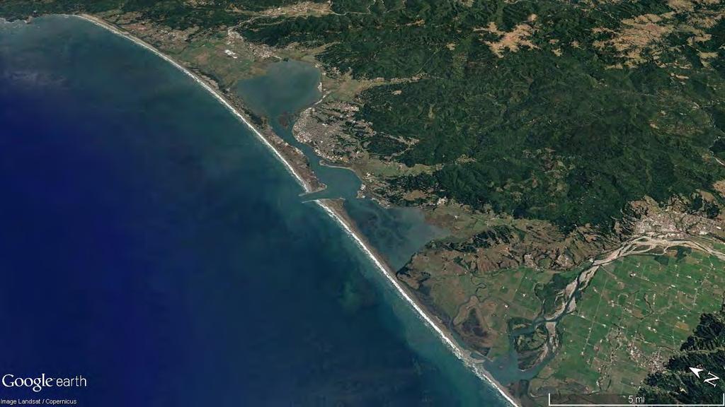
7 Sediment Management: Eureka Littoral Cell 40 miles of coastline Eel, Mad and Little Rivers Coastal dune fields
8 Sediment Budget (per CRSMP) Source Name Rivers Discharging to Pacific Ocean Total Sand Volume (cy) (Sand> mm) Little River 53,000 37,000 Mad River 690, ,000 Eel River 3,600,000 2,300,000 Subtotal 4,340,000 2,823,000 Rivers/Creeks Discharging to Humboldt Bay Elk River, Freshwater Creek, Salmon Creek and Jacoby Creek Beach Size Fraction (cy) (>0.125 mm) Unknown but small (total yield is ~36,000 cy, mostly silt)
9 Maintenance Dredging Dredging Sponsor Annual Volume (cy) Disposal Site Federal (USACE) 1,203,300 (sand) HOODS Local (Harbor District, City of Eureka, Private) 25,000 (silt) Various

10 Maintenance Dredged Navigation Channels in Humboldt Bay

11 Sediment Placement Sites- Past and Present

12 Historic Shoreline Mapping (1939-present) Humboldt Bay dunes appear stable except for hot spot on North Spit Sediment deficit apparent south of Eel River mouth

13 North Spit Erosional Area
14 Marsh Accretion Rates vs. Relative Sea Level Rise Area Accretion Rates (mm/yr) RSLR* (mm/yr) North Bay Mad River Slough Jacoby Creek Marsh South Bay White Slough Hookton Slough *RSLR includes Vertical Land Motion, which is variable from North to South in Humboldt Bay (higher in the south).

15 SLR Inundation Maps- Arcata Bay

16 SLR Inundation Maps- Eureka

17 SLR Inundation Maps- South Bay
 Shoreline 60 miles U.S. Coast Survey 1870")
18 Historical Conditions 1870 Open Water 60% (15,800 ac) Salt Marsh 40% (10,500 ac) Shoreline 60 miles U.S. Coast Survey 1870
 Shoreline 102 miles Artificial 75 % (77 miles) Natural 25% (26 miles)")
19 Current Conditions 2014 Open Water 90% (15,800 acres) Salt Marsh 10% (-9,000 acres) Shoreline 102 miles Artificial 75 % (77 miles) Natural 25% (26 miles)

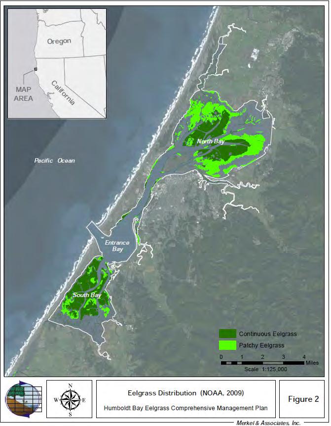
20 Humboldt Bay Eelgrass

21 Shoreline Structure Dike = 53%, 41 miles Natural = 25 %, 25 miles Railroad = 14 %, 11 miles

22 Red=High Yellow=Moderate Green=Low Shoreline Vulnerability

23 U.S. Highway 101 Critical Regional Public Asset

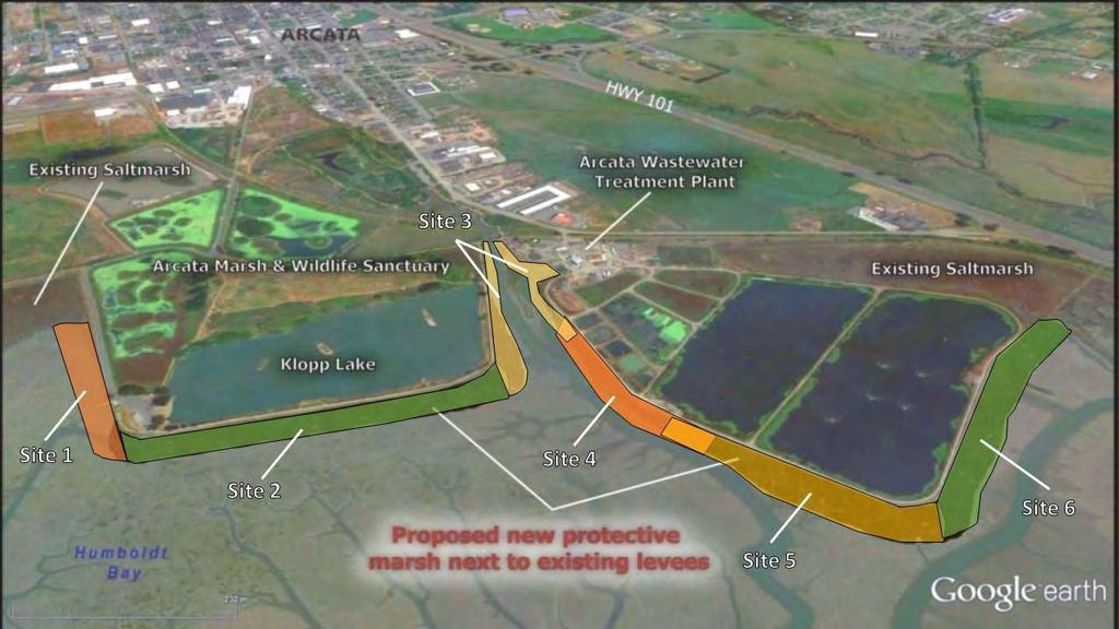
24 Beneficial Sediment Reuse for Living Shorelines/ Hwy 101 Protection


25 Living Shorelines Wetlands White Slough Restoration (SCC, USFWS) Arcata Bay Adaptation Measures (City of Arcata) Bolinas Lagoon Wetland Enhancement/SLR Adaptation (Marin County Open Space) South Bay Salt Ponds (SCC and Partners) Seal Beach Sediment Augmentation (Southwest Wetlands Interpretive Association)

26 Project Location


27 Considering Local Conditions Physical Elements Habitat Hardscape Infrastructure Aesthetics/ Community

28 Benthic Habitat Distribution Yellow=Marshes Light Orange=Mudflat Project site in mudflats

29 Narrow band of fringe marsh and mudflats

30 Barrier Heights Arcata Bay Range 3 to 14+ Upper Arcata Bay Reach Tidal Elevation
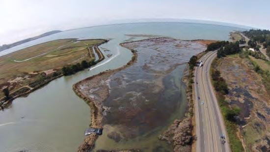
31 Living Shoreline Components
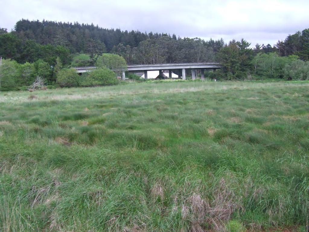
32 Design Exploration


33 Rocks, oyster reefs Coir logs Oyster bags. Coastal Resources Management 2015 Ocean and Coastal Consultants 2014 Large woody debris


34 Some Conceptual Designs Concepts Salt marsh veg / breakwater Horizontal Levee variations


35 City of Arcata Living Shoreline Concept Design Plans (2016) Coir logs Oyster reefs Large wood
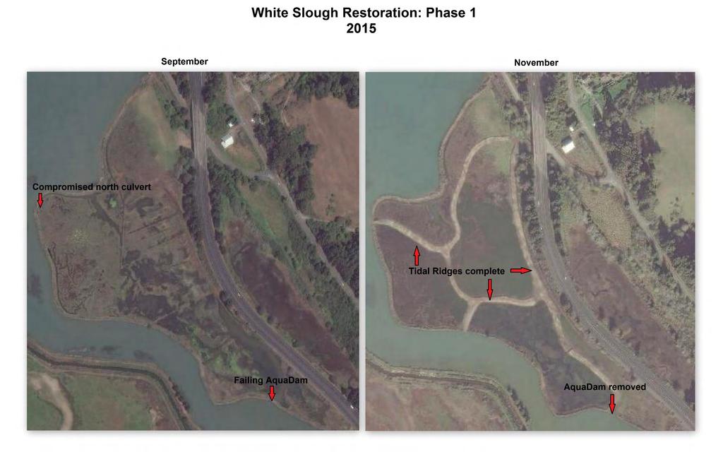
36
37
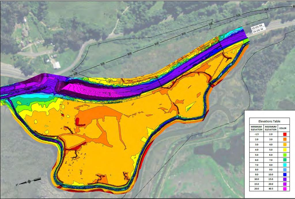
38
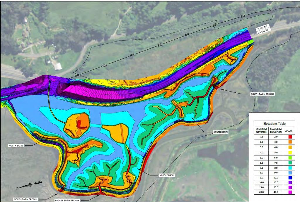
39

40 Adjacent Marsh Restoration Sites McDaniel Slough Project site Jacoby Creek


41 Subsided 40 acre brackish marsh behind failing dikes White Slough Restoration

42 Adjacent to Highway 101 and College of the Redwoods access road Project location

43 Project Area

44 Project area Inundation with MMMW yr stillwater level (9.99 ft)
45

46 Pre-project Levee Breach
47
48 Existing topography
49 Proposed topography
50

51 Project Actions

52 Post-Project Habitat Types
53

54 2017 Status
55 Project constraints Caltrans engineering specs required a setback of the project Finding and permitting sediment for beneficial reuse is difficult and time consuming
56 Project benefits Marsh habitat Wave attenuation to protect highway embankment and access road Increased accretion
57 CONCLUSIONS Sea Level Rise Vulnerability Tidal Marshes Agricultural Land/Seasonal Wetlands Human Communities Sediment Management Exporting sediment from littoral cell Need for beneficial reuse Living Shorelines a promising approach
58 Thank you!
Design of Levee Breaches in Sheltered Water for Flood Risk Reduction & Marsh Restoration ASFMP; June 5, 2014 Presented By:
 Design of Levee Breaches in Sheltered Water for Flood Risk Reduction & Marsh Restoration ASFMP; June 5, 2014 Presented By: Rohin Saleh Alameda County Flood Control District Matt Powers, P.E. GEI Consultants
Carbon Sequestration Potential from Coastal Wetlands Restoration Sites
 Carbon Sequestration Potential from Coastal Wetlands Restoration Sites Insert then choose Picture select your picture. Right click your picture and Send to back. Paul Krause, Alyssa Beach Emily Cooper,
Sea-level Rise on Cape Cod: How Vulnerable Are We? Rob Thieler U.S. Geological Survey Woods Hole, MA
 Sea-level Rise on Cape Cod: How Vulnerable Are We? Rob Thieler U.S. Geological Survey Woods Hole, MA Outline Sea-level and coastal processes Past sea-level change Predictions for the future Coastal responses
Sri Lanka has a coastline of km excluding the shoreline of bays and inlets.
 Defining and Demarcating Coastal zones in Sri Lanka Procedure, Challenges and What needs to be done? Dr. Anil Premaratne Director General Coast Conservation Coast Conservation Department Sri Lanka 1 Sri
Sunset Harbour / Huntington Harbour Maintenance Dredging and Waterline Installation Project. CMANC 21 January 2016
 Sunset Harbour / Huntington Harbour Maintenance Dredging and Waterline Installation Project CMANC 21 January 2016 County of Orange Footprint Huntington Harbour Operational and Dredging Cost Sharing Agreements
Heather Schlosser Army Corps of Engineers Coastal Studies Group August 28, 2008
 Got sand? Regional Sediment Management in Orange County Heather Schlosser Army Corps of Engineers Coastal Studies Group August 28, 2008 Regional Sediment Management Regional sediment management recognizes
THIN-LAYER PLACEMENT OF DREDGE MATERIAL FOR MARSH NOURISHMENT, RESOTRATION, AND RESPONSE TO SEA LEVEL RISE
 THIN-LAYER PLACEMENT OF DREDGE MATERIAL FOR MARSH NOURISHMENT, RESOTRATION, AND RESPONSE TO SEA LEVEL RISE Case studies and lesson learned regarding thin-layer deposition projects in Delaware, New Jersey,
APPENDIX F SEDIMENT DEPOSITION AND HABITAT CONVERSION ANALYSIS
 APPENDIX F SEDIMENT DEPOSITION AND HABITAT CONVERSION ANALYSIS San Dieguito Lagoon W-19 Restoration Project Draft EIR March 2017 Appendices Introduction: The following is an analysis to provide the volume
EAGLES NEST AND PIASA ISLANDS
 EAGLES NEST AND PIASA ISLANDS HABITAT REHABILITATION AND ENHANCEMENT PROJECT MADISON AND JERSEY COUNTIES, ILLINOIS ENVIRONMENTAL MANAGEMENT PROGRAM ST. LOUIS DISTRICT FACT SHEET I. LOCATION The proposed
GALVESTON BAY RSM Moving toward an Integrated, Cooperative, and Holistic Approach to Estuarine Sediments
 GALVESTON BAY RSM Moving toward an Integrated, Cooperative, and Holistic Approach to Estuarine Sediments RAE Conference 2010 Larry A. Wise Moffatt & Nichol RSM is a system-based approach for collaboratively
Australian Coastal Councils Conference
 Australian Coastal Councils Conference 11 March 2015 Estimating Future Coastal Inundation and Erosion Hazards Dr Andrew McCowan Dr Christine Lauchlan-Arrowsmith Warwick Bishop Background Victorian Future
ENGINEERING APPROACHES TO SHORELINE PLACEMENT FROM COAST TO COAST
 ENGINEERING APPROACHES TO SHORELINE PLACEMENT FROM COAST TO COAST 237 237 237 217 217 217 200 200 200 0 0 0 163 163 163 131 132 122 80 119 27 252 174.59 83 36 118 110 135 120 112 92 56 62 102 130 Comparing
The Coast: Beaches and Shoreline Processes
 1 2 3 4 5 6 7 8 9 The Coast: es and Shoreline Processes Trujillo & Thurman, Chapter 10 Oceanography 101 Chapter Objectives Recognize the various landforms characteristic of beaches and coastal regions.
Alexandra Carvalho, Ph.D., GISP Kathy Fitzpatrick, P.E.
 Coastal Data Organization for Project Management and Coastal Planning Martin County, Florida Alexandra Carvalho, Ph.D., GISP Kathy Fitzpatrick, P.E. Outline County Coastal Programs Coastal Geodatabase
The Coast: Beaches and Shoreline Processes Trujillo & Thurman, Chapter 10
 The Coast: es and Shoreline Processes Trujillo & Thurman, Chapter 10 Oceanography 101 Chapter Objectives Recognize the various landforms characteristic of beaches and coastal regions. Identify seasonal
Del Mar Sediment Management Study
 Del Mar Sediment Management Study Shoreline Preservation Working Group, June 7, 2018 Lindsey Sheehan Current work in Del Mar 2016 Sea-Level Rise Vulnerability Assessment 2018 Adaptation Plan 2018 Sediment
Primer on Coastal Erosion And Habitat Creation
 2 nd Regional Conference Dredging, Beach Nourishment & Bird Conservation Primer on Coastal Erosion And Habitat Creation Timothy Kana Ph.D Source: Newsday 1962 Photo by Kelsey Aerials 1978 Source: U Mass
Whiskey Island Marsh Creation Rolling with the Punches
 Whiskey Island Marsh Creation Rolling with the Punches Santiago Alfageme, M&N Jerry Carroll, LADNR Brad Miller, LADNR Project Location Historic Island Retreat Previous Restoration Project Whiskey Island
3. MARINE HABITAT RESTORATION
 Feasibility Study for Restoration of Titlow Lagoon Fish Passage South Puget Sound Salmon Enhancement Group 3. MARINE HABITAT RESTORATION Marine habitat restoration at Titlow Park could include restoration
Sea Level Rise Providing Nature A-Right-of Way
 Sea Level Rise Providing Nature A-Right-of Way Study Area Site 2: Skagit Bay Initial Condition 11.2 Inches by 2050 No Dikes 27.3 Inches by 2100 No Dikes The Problem Loss of coastal wetlands due to submergence
Shoreline and Climate Change Adaptation Alternatives for The Letter Parcel, Bolinas Lagoon
 Shoreline and Climate Change Adaptation Alternatives for The Letter Parcel, Bolinas Lagoon Scenic shoreline vista of Bolinas Lagoon and ridges, from Letter Parcel, March 2016 Peter Baye, Coastal Ecologist
Puget Sound Shorelines. Announcements
 Announcements Puget Sound Shorelines Wednesday discussion of Bates paper Bham Bay project: Updates, finals week schedules Last portion of the class: Environmental issues in Puget Sound Puget Sound shorelines:
Regional-scale understanding of the geologic character and sand resources of the Atlantic inner continental shelf, Maine to Virginia
 Regional-scale understanding of the geologic character and sand resources of the Atlantic inner continental shelf, Maine to Virginia Workshop on Dredging, Beach Nourishment and Bird Conservation Atlantic
Port of Kalama, 2013 TEMCO Berth Maintenance Dredging and In-water Flow-Lane Placement Project
 2014 WEDA ENVIRONMENTAL EXCELLENCE AWARDS Category: Navigation Dredging Port of Kalama, 2013 TEMCO Berth Maintenance Dredging and In-water Flow-Lane Placement Project Port of Kalama, Washington 18 April
APPENDIX H SAN DIEGUITO LAGOON W-19 INLET AND OCEAN ENTRANCE MAINTENANCE STUDY
 APPENDIX H SAN DIEGUITO LAGOON W-19 INLET AND OCEAN ENTRANCE MAINTENANCE STUDY San Dieguito Lagoon W-19 Restoration Project Final EIR November 2018 Appendices 3780 Kilroy Airport Way, Suite 600 Long Beach,
Sediment Management in the Coastal Bays
 Sediment Management in the Coastal Bays Introduction Need for ecosystem view of sediment management in Coastal Bays Island loss and restoration Navigation needs Habitat Trade offs Living Shoreline Requirements
SHORELINE PROTECTION & RESTORATION PROGRAM
 City of Mandeville, LA SHORELINE PROTECTION & RESTORATION PROGRAM June 8, 2017 Pre-Budget Background Presentation Prepared by: Overview Background Context: RSLR, Rigolets Closure City Program & Project
Long-Distance Pumping and Opportunities for Engineering with Nature
 Long-Distance Pumping and Opportunities for Engineering with Nature Tim Welp and Derek Wilson Tim Welp Research Hydraulic Engineer Coastal and Hydraulics Laboratory 23 October 2012 Engineering with Nature
MEMORANDUM FOR SWG
 MEMORANDUM FOR SWG-2007-1623 Subject: Jurisdictional Determination (JD) for SWG-2007-1623 on Interdunal Wetlands Adjacent to Traditional Navigable Waters (TNWs) Summary The U.S. Environmental Protection
Coastal Processes 101. Greg Berman (Woods Hole Sea Grant & Cape Cod Cooperative Extension)
") Coastal Processes 101 Greg Berman (Woods Hole Sea Grant & Cape Cod Cooperative Extension) January 23, 2019 Coastal Processes 101 Outline: ~30 min talk Coastal Processes What is Erosion? Value of the Ecosystem
Coastal Processes 101 Greg Berman (Woods Hole Sea Grant & Cape Cod Cooperative Extension) January 23, 2019 Coastal Processes 101 Outline: ~30 min talk Coastal Processes What is Erosion? Value of the Ecosystem
Adaptation to Sea Level Rise A Regional Approach
 Adaptation to Sea Level Rise A Regional Approach Project Partners: in Saco Bay, ME Peter Slovinsky, Marine Geologist Maine Geological Survey, Department of Conservation Project Funding from: Saco Bay Hazards
A SEDIMENT BUDGET ANALYSIS AND MANAGEMENT STRATEGY FOR FORT PIERCE INLET, FL
 A SEDIMENT BUDGET ANALYSIS AND MANAGEMENT STRATEGY FOR FORT PIERCE INLET, FL By Elba Rodriguez and Robert G. Dean Department of Civil and Coastal Engineering University of Florida Gainesville, FL 32611,
Seagrass Transplantation & Environmental & Marine Consulting Services, Inc. Drew Campbell, Vice President & Lead Scientst.
 Indian River Lagoon Symposium Seagrass Transplantation & Project Considerations Environmental & Marine Consulting Services, Inc. Drew Campbell, Vice President & Lead Scientst March 26 th, 2013 Regulatory
Regional Sediment Management
 Regional Sediment Management Linda S. Lillycrop Program Manager Coastal Engineer US Army Engineer Research and Development Center Coastal and Hydraulics Laboratory Q AVG Coastal Resilience: The Environmental,
IS THERE ENOUGH SEDIMENT? Presentation at the State of the Estuary Conference San Francisco, CA, October 9-10, By Philip B.
 IS THERE ENOUGH SEDIMENT? Presentation at the State of the Estuary Conference San Francisco, CA, October 9-10, 2001 By Philip B. Williams 1. INTRO I AM TEMPTED TO MAKE THIS THE SHORTEST TALK OF THE CONFERENCE:
Chapter 3 - White Oak River Subbasin Includes Bogue Sound and the Newport River
 Chapter 3 - White Oak River Subbasin 03-05-03 Includes Bogue Sound and the Newport River 3.1 Water Quality Overview Subbasin 03-05-03 at a Glance Land and Water Area (sq. mi.) Total area: 228 Land area:
Island Design. UMRS EMP Regional Workshop. Presentation for the
 Island Design Presentation for the UMRS EMP Regional Workshop by Jon Hendrickson Hydraulic Engineer Regional Technical Specialist, Water Quality and Habitat Restoration August 17 19, 2005 Project Delivery
Mapping of Future Coastal Hazards. for Southern California. January 7th, David Revell, Ph.D. E.
 Mapping of Future Coastal Hazards for Southern California January 7th, 2014 David Revell, Ph.D. drevell@esassoc.com E. Vandebroek, 2012 Outline Coastal erosion hazard zones Flood hazard zones: Coastal
Application #: TEXT
 TOWN OF FORT MYERS BEACH 2008 PROPOSED COMPREHENSIVE PLAN AMENDMENTS Application #: 2008-13-TEXT Description: Modify the Coastal Management and Future Land Use Elements to reflect the state s new definition
memorandum Preliminary Implementation Options Overview Coastal Armor by Reach San Francisco Littoral Cell CRSMP Stakeholder Advisory Group
 550 Kearny Street Suite 900 San Francisco, CA 94108 415.262.2300 phone 415.262.2303 fax www.pwa-ltd.com memorandum date June 5, 2012 to from subject San Francisco Littoral Cell CRSMP Stakeholder Advisory
Earth Wind & Fire. Game Changing Restoration Options in the Texas Chenier Plain
 Earth Wind & Fire Game Changing Restoration Options in the Texas Chenier Plain EARTH: The Chenier Plain is a 5 million acre coastal region in Southwest Louisiana and Southeast Texas providing landscape
Assessing marsh response from sea-level rise applying local site conditions: Humboldt Bay wetlands
 Assessing marsh response from sea-level rise applying local site conditions: Humboldt Bay wetlands U. S. Geological Survey, Western Ecological Research Center Addendum - Data Summary Report February 23,
Coastal Inlets Research Program US Army Corps of Engineers Engineering Research and Development Center
 Coastal Inlets Research Program US Army Corps of Engineers Engineering Research and Development Center Site of Moriches Inlet Nov. 1951 Julie Dean Rosati and Nicholas C. Kraus, CIRP Program Manager Shinnecock
TIDAL EROSION AT ELKHORN SLOUGH
 TIDAL EROSION AT ELKHORN SLOUGH Virtually all of California s tidal wetlands have been dramatically altered. Hydrological manipulations changes in water flow are widespread. Either flow has been decreased
MISSISSIPPI COASTAL IMPROVEMENTS
 MISSISSIPPI COASTAL IMPROVEMENTS PROGRAM (MsCIP) Comprehensive Barrier 237 27 200 237 27 200 Island 237 Restoration 27 200 Plan 80 9 27 252 74.59 255 255 255 0 0 0 63 63 63 3 32 22 239 65 53 0 35 20 2
Types of Wetlands. Tidal Systems
 Types of Wetlands Tidal Systems 1 COASTAL WETLAND ECOSYSTEMS Tidal Salt Marshes Tidal Freshwater Marshes Mangrove Wetlands 2 Tidal Estuarine Wetland 3 Definition and Formation of Estuaries Estuary: : partially
Subtidal permanently flooded with tidal water. Irregularly exposed surface exposed by tides less often than daily
 Types of Wetlands Tidal Systems COASTAL WETLAND ECOSYSTEMS Tidal Salt Marshes Tidal Freshwater Marshes Mangrove Wetlands Tidal Estuarine Wetland 1 Definition and Formation of Estuaries u Estuary : partially
Sea-level Rise and Storm Effects on Coastal Systems under Changing Global Climate. Cape May, NJ 12 January 2009
 Sea-level Rise and Storm Effects on Coastal Systems under Changing Global Climate 2009 Delaware Estuary Science Summit Cape May, NJ 12 January 2009 S. Jeffress Williams Senior Coastal Marine Geologist
Home About Us Articles Press Releases Image Gallery Contact Us Media Kit Free Subscription 10/5/2006 5:56:35 PM
 Home About Us Articles Press Releases Image Gallery Contact Us Media Kit Free Subscription 10/5/2006 5:56:35 PM Industry Resources Industry Directory NASA Links Missions/Launches Calendar Human development
Newsletter # 2. Pilot sites in Greece. December 2018
 A HarmonizEd framework to Mitigate coastal EroSion promoting ICZM protocol implementation Newsletter # 2 December 2018 View of a beach in Ammolofi ( Paggaio Municipality ) Pilot sites in Greece 1. Name
Lower South Fork McKenzie River Floodplain Enhancement Project
 Lower South Fork McKenzie River Floodplain Enhancement Project McKenzie River Ranger District Willamette National Forest Project Location The project is located in the South Fork McKenzie River Watershed,
RESULTS FROM THE TEXAS COASTAL SEDIMENT SOURCES: A GENERAL EVALUATION STUDY
 RESULTS FROM THE TEXAS COASTAL SEDIMENT SOURCES: A GENERAL EVALUATION STUDY JUAN MOYA KELSEY CALVEZ CRIS WEBER ANTHONY RISKO *KEVIN FRENZEL FREESE AND NICHOLS, INC. COASTAL AND WATERWAYS GROUP OBJECTIVES
Landslide & Coastal Erosion Risk Reduction at Oregon s Water/Wastewater Networks
 Landslide & Coastal Erosion Risk Reduction at Oregon s Water/Wastewater Networks Laura Gabel, RG (with Bill Burns, RG & Jonathan Allan, Ph. D) Oregon Department of Geology and Mineral Industries (541)
Connecticut Coastal Management Program
 Connecticut Coastal Management Program Fact Sheet for SHORELINE FLOOD AND EROSION CONTROL STRUCTURES What are Shoreline Flood and Erosion Control Structures? The Connecticut General Statutes (CGS) define
SHORELINE AND BEACH PROCESSES: PART 2. Implications for Coastal Engineering
 SHORELINE AND BEACH PROCESSES: PART 2 Implications for Coastal Engineering Objectives of the lecture: Part 2 Show examples of coastal engineering Discuss the practical difficulties of ocean engineering
Bolinas Lagoon Sedimentation. Sedimentation rate in the North Basin of Bolinas Lagoon, California Jordan Malin
 Sedimentation rate in the North Basin of Bolinas Lagoon, California Jordan Malin Abstract Bolinas Lagoon exists as a haven for birds and marine life as well as an aesthetic addition to the West Marin communities.
Preliminary Data Release for the Humboldt Bay Sea Level Rise Vulnerability Assessment: Humboldt Bay Sea Level Rise Inundation Mapping
 Preliminary Data Release for the Humboldt Bay Sea Level Rise Vulnerability Assessment: Humboldt Bay Sea Level Rise Inundation Mapping Prepared by: Jeff Anderson, Northern Hydrology & Engineering (jeff@northernhydrology.com)
Material Workshop. Galveston District 2012 Beneficial Use of Dredged. Material Workshop. Custodians of the Coast
 Galveston District 2012 Beneficial Use of Dredged Material Workshop Galveston District 2012 Beneficial Use of Dredged Material Workshop US Army Corps of Engineers BUILDING STRONG Welcome Opening Remarks
Integrating new coastline information and geographically coordinated coastal geomorphology data
 Integrating new coastline information and geographically coordinated coastal geomorphology data NOAA Contemporary Shoreline DOE Coastal Geomorphology Cynthia Miller Corbett Jeff Simley 1 National Hydrography
Some Thoughts on the Role of Elevation
 Some Thoughts on the Role of Elevation Data in Sea-level Rise Impact Assessments Rob Thieler* U.S. Geological Survey Coastal and Marine Geology Program Woods Hole, MA *i l d t i l d f D C h D G h *includes
Oyster Reef for Shoreline Stabilization and Restoration. Jason Kirkpatrick Conservation Program Manager MacDill AFB Tampa, Florida
 Oyster Reef for Shoreline Stabilization and Restoration Jason Kirkpatrick Conservation Program Manager MacDill AFB Tampa, Florida Interbay Penninsula Port of Tampa X The few remaining mangroves are being
Coastal Sediment Properties and Longshore Sediment Transport
 Coastal Sediment Properties and Longshore Sediment Transport Julie Rosati Julie.D.Rosati@erdc.usace.army.mil 601-634-3005 Coastal Planning Course Lesson #8 Tuesday 8:00-9:00 am CEM III-1, III-2 1. Coastal
UNIT 2 WARM UP. List the OCEANS. Bonus: Name the Largest LAKE on Earth
 UNIT 2 WARM UP List the OCEANS Bonus: Name the Largest LAKE on Earth Land Forms Land Mountain Hill Cliff Butte Mesa Plateau Cave Volcano Desert Plains Prairie Steppe Marsh Swamp Tundra Glacier Continent
Coastal Processes 101 & The Regs. Greg Berman (Woods Hole Sea Grant & Cape Cod Cooperative Extension)
") Coastal Processes 101 & The Regs Greg Berman (Woods Hole Sea Grant & Cape Cod Cooperative Extension) March 26, 2019 Coastal Processes 101 & The Regs Outline: ~15 min talk Coastal Processes What is Erosion?
Coastal Processes 101 & The Regs Greg Berman (Woods Hole Sea Grant & Cape Cod Cooperative Extension) March 26, 2019 Coastal Processes 101 & The Regs Outline: ~15 min talk Coastal Processes What is Erosion?
Coastal Impacts of Climate Change in the Northwest: A Summary of the Findings of the upcoming National Climate Assessment
 Western Washington University Western CEDAR Salish Sea Ecosystem Conference 2014 Salish Sea Ecosystem Conference (Seattle, Wash.) May 1st, 3:30 PM - 5:00 PM Coastal Impacts of Climate Change in the Northwest:
Presentation Outline. Project Overview. Sea Level Rise Assessment & Decision Tools. Community Engagement. Tina Whitman, Friends of the San Juans
 Healthy Beaches for People & Fish Sea Level Rise Adaptation Tools for San Juan County, WA Tina Whitman & Andrea MacLennan December 10, 2015 Presentation Outline Project Overview Tina Whitman, Friends of
Seaton to Seaton Hole SUMMARY OF PREFERRED PLAN RECOMMENDATIONS AND JUSTIFICATION
 Location reference: Policy Unit reference: Plan: Seaton to Seaton Hole 6a29 and 6a30 SUMMARY OF PREFERRED PLAN RECOMMENDATIONS AND JUSTIFICATION The large number of properties and assets at risk in the
3.0 GEOLOGY, SEISMICITY, AND TSUNAMIS
 3.0 GEOLOGY, SEISMICITY, AND TSUNAMIS 3.1 BACKGROUND AND SETTING 3.1.1 Geology, Seismicity, and Ground Stability The general geological setting for the Humboldt Bay area is described in subsection 4.2.2
TEXAS COASTAL GEOLOGICAL DREDGING VS. GEOTECHNICAL DREDGING: CAN WE ANTICIPATE THE FUTURE?
 TEXAS COASTAL GEOLOGICAL DREDGING VS. GEOTECHNICAL DREDGING: CAN WE ANTICIPATE THE FUTURE? J.C. Moya 1, M. Mahoney 2, T. Dellapenna 3, C. Weber 1, T. Dixon 1 ABSTRACT How much do we really know about our
Coastal Processes and Shoreline Erosion on the Oregon Coast, Cascade Head to Cape Kiwanda
 State of Oregon Department of Geology and Mineral Industries Vicki S. McConnell, State Geologist Open File Report OFR O-04-11 Coastal Processes and Shoreline Erosion on the Oregon Coast, Cascade Head to
Supplemental Slides. Shore: Junction of Land & Water. Junction of Land & Water. Sea Level Variations. Shore vs. Coast. Sea Level Variations
 Shore: Junction of Land & Water Supplemental Slides Sediments come off land Most get dumped at the beach Sediment interacts with ocean waves and currents Junction of Land & Water Features: Breaking waves,
Shore: Junction of Land & Water. Sediments come off land Most get dumped at the beach Sediment interacts with ocean waves and currents
 Shore: Junction of Land & Water Supplemental Slides Sediments come off land Most get dumped at the beach Sediment interacts with ocean waves and currents Junction of Land & Water Features: Breaking waves,
DESIGN ENGINEERING ANALYSIS FOR TERMINAL GROIN LENGTH
 APPENDIX F DESIGN ENGINEERING ANALYSIS FOR TERMINAL GROIN LENGTH (Prepared by Olsen Associates, Inc.) DRAFT Environmental Impact Statement Village of Bald Head Island Shoreline Protection Project Brunswick
Coastal Vulnerability and Risk Parameters
 European Water 11/12: 3-7, 2005. 2005 E.W. Publications Coastal Vulnerability and Risk Parameters E. Doukakis National Technical University of Athens-Dept. of Rural and Surveying Engineering, Lab. of Higher
The Use of Geographic Information Systems to Assess Change in Salt Marsh Ecosystems Under Rising Sea Level Scenarios.
 The Use of Geographic Information Systems to Assess Change in Salt Marsh Ecosystems Under Rising Sea Level Scenarios Robert Hancock The ecological challenges presented by global climate change are vast,
The Role of Coastal Forest and Trees in Combating Coastal Erosion
 Regional Technical Workshop, 28-31 August 2006, Khaolak, Thailand Coastal Protection in the aftermath of the Indian Ocean tsunami: What role of coastal forest and trees? The Role of Coastal Forest and
Solutions to Flooding on Pescadero Creek Road
 Hydrology Hydraulics Geomorphology Design Field Services Photo courtesy Half Moon Bay Review Solutions to Flooding on Pescadero Creek Road Prepared for: San Mateo County Resource Conservation District
Influence of the Major Drainages to the Mississippi River and Implications for System Level Management
 Influence of the Major Drainages to the Mississippi River and Implications for System Level Management Brian M. Vosburg Geologist Louisiana Coastal Protection and Restoration Authority brian.vosburg@la.gov
Swift Creek Sediment Management Action Plan (SCSMAP)
") Swift Creek Sediment Management Action Plan (SCSMAP) PHASE 3 PROJECT PLAN PROPOSAL Whatcom County Public Works Department 322 N. Commercial Street, Suite 210 Bellingham, WA 98225 (360) 676-6692 June 2013
Swift Creek Sediment Management Action Plan (SCSMAP) PHASE 3 PROJECT PLAN PROPOSAL Whatcom County Public Works Department 322 N. Commercial Street, Suite 210 Bellingham, WA 98225 (360) 676-6692 June 2013
Relatively little hard substrate occurs naturally in the
 CHAPTER FIVE Rock Habitats Relatively little hard substrate occurs naturally in the estuary, owing mainly to the vast quantities of fine sediment that have been deposited by the rivers. Rock habitat is
Adapting to Rising Sea Level & Extreme Weather Events:
 Adapting to Rising Sea Level g & Extreme Weather Events: A Florida Perspective Randall W. Parkinson, Ph.D., P.G. President RWParkinson Consulting, Inc. Melbourne, Florida & Administrator Space Coast Climate
Analysis of Tides and Storm Surge from Observational Records in the Delaware Inland Bays
 Analysis of Tides and Storm Surge from Observational Records in the Delaware Inland Bays John Callahan Delaware Geological Survey Coastal GeoTools Conference March 30 April 2, 2015 Charleston, SC Outline
The Systems Approach. Alun Williams, ABPmer
 The Systems Approach Alun Williams, ABPmer Overview What is A Systems Approach? Behavioural / Qualitative Modelling? System Definition / Mapping (Behavioural Statements Objective) What is a Systems Approach?
South Carolina Coastal Habitats
 South Carolina Coastal Habitats By C. Livingston, 2009 Earth Where is South Carolina? North America United States of America SC Here we are! South Carolina borders the Atlantic Ocean. Did you know? South
ΛTKINS. Applications of Regional Sediment Management Concepts in Texas Estuarine Restoration Projects. Riparian Workshop Fort Worth, October 17, 2012
 Juan C Moya, PhD., PG Coastal Planning and Restoration Applications of Regional Sediment Management Concepts in Texas Estuarine Restoration Projects Riparian Workshop Fort Worth, October 17, 2012 West
Shoreline Evolution: City of Hampton, Virginia Chesapeake Bay, Back River, and Hampton River Shorelines
 Shoreline Evolution: City of Hampton, Virginia Chesapeake Bay, Back River, and Hampton River Shorelines Virginia Insitute of Marine Science College of William & Mary Gloucester Point, Virginia September
Swift Creek Sediment Management Action Plan (SCSMAP)
") Swift Creek Sediment Management Action Plan (SCSMAP) PHASE 2 PROJECT PLAN PROPOSAL Whatcom County Public Works Department 322 N. Commercial Street, Suite 210 Bellingham, WA 98225 (360) 676-6692 June 2013
Swift Creek Sediment Management Action Plan (SCSMAP) PHASE 2 PROJECT PLAN PROPOSAL Whatcom County Public Works Department 322 N. Commercial Street, Suite 210 Bellingham, WA 98225 (360) 676-6692 June 2013
June 2018 Sediments and Dredging at GBR Ports
 June 2018 Sediments and Dredging at GBR Ports Reef 2050 Long Term Sustainability Plan The Great Barrier Reef is over 2000 km long and covers an area of approximately 350,000 square kilometres. It is a
Scenarios for the NI coast in the 21 st Century
 Scenarios for the NI coast in the 21 st Century Prof Julian Orford Geography, Archaeology & Palaeoecology Queen s University, Belfast Challenging perspective Living by the coast is good for your health!
Salt Marsh Erosion Control. Danielle Kreeger Partnership for the. Haskin Shellfish Research Lab Rutgers University
 Mussel Powered Living Shorelines for Salt Marsh Erosion Control Danielle Kreeger Partnership for the Delaware Estuary David Bushek Haskin Shellfish Research Lab Rutgers University Other Scientists: Laura
DELINEATION OF COASTAL SET-BACK LINES AND OVERLAY ZONES IN WEST COAST DISTRICT
 DELINEATION OF COASTAL SET-BACK LINES AND OVERLAY ZONES IN WEST COAST DISTRICT I. Bekko C. George IAIA Conference August 2014 Content Background and Context Process followed for West Coast District Set-back
Appendix I. Dredged Volume Estimates. Draft Contractor Document: Subject to Continuing Agency Review
 Appendix I Dredged Volume Estimates Draft Contractor Document: Subject to Continuing Agency Review Interoffice Correspondence Date: April 6, 2007 To: L. Bossi (WHI) Copy: S. Thompson (WHI), B. Fidler (NNJ)
9 th INTECOL Orlando, Florida June 7, 2012
 Restoration of the Everglades Saline Wetlands and Florida Bay: Responses Driven from Land and Sea David Rudnick 1, Colin Saunders 2, Carlos Coronado 2, Fred Sklar 2 Erik Stabenau 1, Vic Engel 1, Rene Price
Geology Setting Management Options Management Structure
 Geology Setting Management Options Management Structure WFF = Wallops Flight Facility LST = Longshore sediment transport SLR = Sea level rise September 29, 2015 Accomack County/Accomack Northampton County
Highland Lake Bathymetric Survey
 Highland Lake Bathymetric Survey Final Report, Prepared For: The Town of Highland Lake 612 Lakeshore Drive Oneonta, AL 35121 Prepared By: Tetra Tech 2110 Powers Ferry Road SE Suite 202 Atlanta, GA 30339
MODELING OF EROSION CONTROL ALTERNATIVES AT STUMP PASS, CHARLOTTE COUNTY
 2014 NATIONAL CONFERENCE ON BEACH PRESERVATION TECHNOLOGY FEBRUARY 13, 2014 MODELING OF EROSION CONTROL ALTERNATIVES AT STUMP PASS, CHARLOTTE COUNTY 1 VADIM ALYMOV, PH.D. 2 CHUCK MOPPS 3 MICHAEL POFF,
Randall W. Parkinson, Ph.D., P.G. Institute of Water and Environment Florida International University
 An Update on Adaptation Action Activities Undertaken Since Completion of the City of Satellite Beach (FL) Vulnerability Assessment to Rising Seas (2010) Randall W. Parkinson, Ph.D., P.G. Institute of Water
Protecting the Storm Damage Prevention and Flood Control Interests of Coastal Resource Areas
 Protecting the Storm Damage Prevention and Flood Control Interests of Coastal Resource Areas Presented by: Massachusetts Department of Environmental Protection & Massachusetts Office of Coastal Zone Management
Draft exercise for share fair at Bozeman workshop only. This exercise is not ready for distribution. Please send helpful suggestions to
 Draft exercise for share fair at Bozeman workshop only. This exercise is not ready for distribution. Please send helpful suggestions to foleyd@plu.edu Figure list 1. Trailer photograph 2. Location map
Marine Spatial Data for Marine Spatial Planning. Ocean Leadership 2010 Public Policy Forum
 Marine Spatial Data for Marine Spatial Planning Ocean Leadership 2010 Public Policy Forum March 10, 2010 Edward Saade President, Fugro EarthData, Inc 1 Marine Spatial Data What is Marine Spatial Data?