Inter State Large Navigable Rivers of the United States
|
|
|
- Ira Kennedy
- 6 years ago
- Views:
Transcription

1 Inter State Large Navigable Rivers of the United States REVIEW OF NORTH AMERICAN BASINS: GREAT LAKES AND MISSISSIPPI RIVER HELEN A. BROHL, EXECUTIVE DIRECTOR US COMMITTEE ON THE MARINE TRANSPORTATION SYSTEM
2 Basins in North America are large in size and in numbers; Basins in North America cross state, regional and national boundaries; Governance over North American basins ranges widely; Sometimes interested stakeholder organizations can have as much influence as governance organizations;

3 Columbia River Great Lakes/St. Lawrence Great Basin Pacific Ocean Seaboard Colorado River Mississippi River and Sub Basins Atlantic Ocean Seaboard Gulf of Mexico Seaboard NORTH AMERICAN BASINS ARE LARGE IN SIZE AND NUMBERS. ALL OF THEM CROSS JURISDICTIONAL BOUNDARIES.
4 GREAT LAKES / SAINT LAWRENCE RIVER

5 MISSISSIPPI RIVER BASIN
6

7 GREAT LAKES ST. LAWRENCE RIVER BASIN Includes: US states of Minnesota, Wisconsin, Illinois, Indiana, Michigan, Ohio, Pennsylvania, New York AND the Canadian provinces of Ontario and Quebec.
8
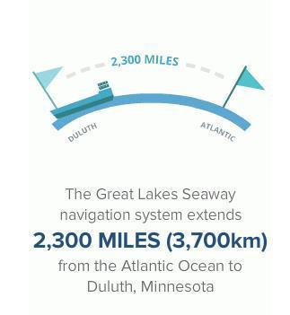
9 One-fifth of all surface freshwater on planet Earth Waterway flows from west to east As it flows from its westernmost point in Duluth, Minnesota to the Atlantic Ocean, the waterway drops in elevation approximately 600 feet (182 m). Locks and Channels Most of the waterway is naturally navigable but public works projects have been carried out by both the U.S. and Canada to construct channels and locks. The Soo Locks Located at Sault Ste Marie, Michigan. Constructed by the U.S. Army Corps of Engineers to address a 21 foot (7 m) elevation change.29.5 feet (9 m) deep. The Poe Lock is 1200 feet (366 m) long, 110 feet (34 m) wide, and 32 feet (10 m) deep. St. Lawrence Seaway Welland Canal Section Welland Canal was constructed by the Government of Canada and cuts across the Niagara Peninsula between Port Weller and Port Colborne, Ontario, a distance of 27 miles (43.4 km). The canal includes eight locks. St. Lawrence Seaway Montreal/Lake Ontario Section Completed in 1959 by the U.S. and Canadian governments. Seven navigation locks five in Canada and two in the United States. Combined, locks lift or lower ships 243 feet (74 m).
10 GOVERNANCE and INTERESTS: Great Lakes / Saint Lawrence State/Provincial US Government Saint Lawrence Seaway Development Corporation US Army Corps of Engineers US Coast Guard Great Lakes Interagency Task Force Canadian Government Saint Lawrence Seaway Management Corporation Hydro Canada Transport Canada Transboundary International Joint Commission Great Lakes Governors Association Great Lakes Commission International Association for Great Lake Research Tribal

11 The Mighty Mississippi flows through 10 US States. The Mississippi Watershed covers 31 states and 2 Canadian Provinces.

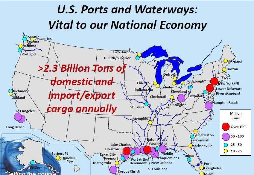
12 Mississippi River The U.S. inland and intracoastal waterway system handles about 630 million tons pf cargo annually, or about 17 percent of all intercity freight by volume Commodities include: Coal Petroleum-based products Grains Aggregates Steel Minerals Dry bulks
13 ASPECTS: MISSISSIPPI RIVER BASIN North America's longest and largest river in terms of discharge, and the fifth largest discharge river worldwide; Mississippi flows 3,763 kilometers (2,333 miles) from Lake Itasca in northern Minnesota to its delta in southern Louisiana; River itself flows through 10 US states; Commercial navigation began in 1830s, USACE removed rock from the Des Moines (Iowa) and Rock Island (Illinois) rapids; Mississippi River watershed is the 4th largest in the world, extending from Allegheny Mtns to the Rocky Mtns in the west; Sub Basins of the Mississippi River watershed include: Ohio River Arkansas Red River Missouri River Mississippi River (trunk) Illinois River
14 GOVERNANCE and INTERESTS: Mississippi River Basin State The Mississippi River Regional Planning Commission is a Commission of nine counties located along the Mississippi River in Western Wisconsin Iowa Office of Systems Planning Illinois Waterways Council US Government US Army Corps of Engineers National Oceanic & Atmospheric Administration US Coast Guard US Fish and Wildlife Service Great Lakes Interagency Task Force Multi-Jurisdictional Mississippi River Commission (est. 1879) Mississippi River Basin Initiative Mississippi River/Gulf of Mexico Watershed Nutrient Task Force
15 GREAT LAKES AND MISSISSIPPI RIVER SYSTEM CHALLENGES Aging Infrastructure Long term constrained civil works funding trend Seasonal and depth constraints of Great Lakes and Inland System Multi-jurisdictional considerations public, local, regional, national Interests may be more than about legal governance should include influential stakeholders Interests are very diverse environmental/operational/financing/strategic/private/ Federal agency business lines cross between watershed, civil works, environmental, etc.
EQ: Discuss main geographic landforms of the U.S. & Canada and examine varied landforms in relation to their lifestyles.
 EQ: Discuss main geographic landforms of the U.S. & Canada and examine varied landforms in relation to their lifestyles. Places & Terms for Discussion Appalachian Mountains Great Plains Canadian Shield
The Mississippi, Missouri, and Ohio Rivers
 The Mississippi, Missouri, and Ohio Rivers Mississippi River Mississippi River begins at Lake Itasca in northwest Minnesota and runs 2,320 miles to the Gulf of Mexico approx. 90 days for a drop of rain
The United States & Canada. A Regional Study of Anglo America
 A Regional Study of Anglo America Landform Regions of the United States & Canada world leaders in agricultural and industrial production because of... VAST LANDS stretch from the Atlantic Ocean on the
discussion of North America s physical features, including its landforms and bodies of
 Chapter 7 Natural Environments of North America Chapter 7 focuses on the natural environments of North America. The chapter opens with a discussion of North America s physical features, including its landforms
Life East of the Mississippi
 Life East of the Mississippi Physical Features ESSENTIAL QUESTION: How does geography influence the way people live? ~The United States can be divided into regions based on physical characteristics. Learning
Terms. divide headwaters tributary fall line fishery
 Chapter 5 Preview Section 1 The Land Objectives Identify some key similarities and differences in the physical geography of the United States and Canada. Explain why rivers have played such an important
Unit 1: Geography. For additional information, refer to this website: 1 G e o g r a p h y
 Unit 1: Geography For additional information, refer to this website: http://mryoungtms.weebly.com/ 1 G e o g r a p h y Continents and Oceans SOL USI. 2a Essential Understanding: Continents are large land
U.S. ARMY CORPS OF ENGINEERS
 CORPS FACTS Regulating Mississippi River Navigation Pools U.S. ARMY CORPS OF ENGINEERS BUILDING STRONG Historical Background Federal improvements in the interest of navigation on the Mississippi River
Unit 1: Geography CLASS WEBSITE: QUIZLET GAMES: ONLINE RESOURCES
 Unit 1: Geography ONLINE RESOURCES CLASS WEBSITE: HTTPS://MRYOUNGTMS.WEEBLY.COM/GEOGRAPHY.HTML QUIZLET GAMES: HTTPS://QUIZLET.COM/JOIN/MSFYY94T5 1 G e o g r a p h y Continents and Oceans The Seven Continents
Terms to Know. divide headwaters tributary fall line fishery
 Chapter Objectives Describe the dominant landforms and natural resources of the United States and Canada. Discuss climate and vegetation in the United States and Canada. Section 1 The Land Section Objectives
UNDERSTANDING GREAT LAKES WATER LEVEL FLUCTUATIONS AND CURRENT CONDITIONS APRIL 2013
 UNDERSTANDING GREAT LAKES WATER LEVEL FLUCTUATIONS AND CURRENT CONDITIONS IL 213 John Allis Chief, Great Lakes Hydraulics and Hydrology Office (313) 226-2137 John.T.Allis@usace.army.mil Keith Kompoltowicz
CHAPTER 1. Geo Challenges 1A to 1D. & World Map Activity
 CHAPTER 1 Geo Challenges 1A to 1D & World Map Activity SELECT YOUR CHALLENGE World Map Activity Challenge 1A Challenge 1B Challenge 1C Challenge 1D Challenge 1A WS PG. 2 STEP #1 Label the largest continent
Physical Geography of the United States and Canada Chapter 5 A Land of Contrasts
 Physical Geography of the United States and Canada Chapter 5 A Land of Contrasts Land Area Together the U.S. and Canada cover more than 7 million square miles. In total area, Canada ranks 2 nd and the
Great Lakes Update. Background
 Great Lakes Update Background The U.S. Army Corps of Engineers, Detroit District, monitors and forecasts the water levels of the Great Lakes. This report summarizes the hydrologic conditions of the Great
Landforms and Bodies of Water
 Chapter 5, Section 1 For use with textbook pages 115 120. The Land Terms to Know divide A high point or ridge that determines the direction that rivers flow (page 118) headwaters The source waters of a
LATITUDE. Latitude lines run to, but are measured & The 0 of latitude that circles the earth is called the?
 LATITUDE Latitude lines run to, but are measured & The 0 of latitude that circles the earth is called the? LATITUDE 0 0 Latitude lines run east to west, but are measured north & south The 0 of latitude
Marine Analysis. LA 23 New. Louisiana. Prepared by:
 Gulf Intracoastal Waterway (GIWW) Marine Vessel Trafficc Analysis LA 23 New Orleans Gulf Coastt Railway Relocation PE/NEPA Project Jefferson and Plaquemines Parishes, Louisiana RPC Task LA23RR1 RPC/FRA
Correction to Spatial and temporal distributions of U.S. winds and wind power at 80 m derived from measurements
 JOURNAL OF GEOPHYSICAL RESEARCH, VOL. 109,, doi:10.1029/2004jd005099, 2004 Correction to Spatial and temporal distributions of U.S. winds and wind power at 80 m derived from measurements Cristina L. Archer
Preview: Making a Mental Map of the Region
 Preview: Making a Mental Map of the Region Draw an outline map of Canada and the United States on the next page or on a separate sheet of paper. Add a compass rose to your map, showing where north, south,
2012 USACE Drought Actions
 2012 USACE Drought Actions for Inland Waterway Users Board 68 Jim Walker Navigation Branch Chief 19 December 2012 US US Army Corps of of Engineers US Drought Monitor 1 2 3 4 6 5 Impacts: 1. The area in
Unit 2. United States Physical Geography
 Unit 2 United States Physical Geography Physical Geography U.S. extends from the Atlantic to Pacific U.S. is the 3rd largest country U.S. has fertile soils, vast forests, and variety of minerals All major
Intercity Bus Stop Analysis
 by Karalyn Clouser, Research Associate and David Kack, Director of the Small Urban and Rural Livability Center Western Transportation Institute College of Engineering Montana State University Report prepared
Prepared by the North American Ice Service. 4 December Seasonal Outlook Great Lakes Winter
 Prepared by the North American Ice Service A collaboration of the Canadian Ice Service and the National/Naval Ice Center 4 December 2008 Seasonal Outlook Great Lakes Winter 2008-2009 - 1 - Table of contents
Challenge 1: Learning About the Physical Geography of Canada and the United States
 60ºN S T U D E N T H A N D O U T Challenge 1: Learning About the Physical Geography of Canada and the United States 170ºE 10ºW 180º 20ºW 60ºN 30ºW 1 40ºW 160ºW 50ºW 150ºW 60ºW 140ºW N W S E 0 500 1,000
Standard Indicator That s the Latitude! Students will use latitude and longitude to locate places in Indiana and other parts of the world.
 Standard Indicator 4.3.1 That s the Latitude! Purpose Students will use latitude and longitude to locate places in Indiana and other parts of the world. Materials For the teacher: graph paper, globe showing
Influence of the Major Drainages to the Mississippi River and Implications for System Level Management
 Influence of the Major Drainages to the Mississippi River and Implications for System Level Management Brian M. Vosburg Geologist Louisiana Coastal Protection and Restoration Authority brian.vosburg@la.gov
Earth Wind & Fire. Game Changing Restoration Options in the Texas Chenier Plain
 Earth Wind & Fire Game Changing Restoration Options in the Texas Chenier Plain EARTH: The Chenier Plain is a 5 million acre coastal region in Southwest Louisiana and Southeast Texas providing landscape
Great Lakes Regional Collaboration and U.S. GEOSS/IOOS/GLOS Initiative Focus on the Huron to Erie Corridor
 Great Lakes Regional Collaboration and U.S. GEOSS/IOOS/GLOS Initiative Focus on the Huron to Erie Corridor USEPA Grosse Ile Lab October 17, 2005 Great Lakes Interagency Task Force Draft Plan calls for
Red River Levee Panel
 Red River Levee Panel Mississippi River Commission Monday, August 9, 2017 Red River Levees in LA & AR NONE along TX & OK Boarder Red River Levee Issues Caddo Levee Cherokee Park Authorization Bossier Levee
High School World History Cycle 2 Week 2 Lifework
 Name: Advisory: Period: High School World History Cycle 2 Week 2 Lifework This packet is due Monday, November 7 Complete and turn in on Friday for 10 points of EXTRA CREDIT! Lifework Assignment Complete
Great Lakes Update Annual Summary. Vol. No. 150 January 7, US Army Corps of Engineers Detroit District
 Vol. No. 150 January 7, 2003 US Army Corps of Engineers Detroit District Great Lakes Update 2002 Annual Summary At times during 2002, each of the Great Lakes experienced water levels that were higher than
Unit 1 Physical Setting
 Unit 1 Physical Setting Chapter 1: Finding Your Way Chapter 2: Our Natural Environment Chapter 3: The Changing Weather Chapter 4: A Place To Live Chapter 1: Finding Our Way Key Terms Lines of Latitude
Confronting Climate Change in the Great Lakes Region. Technical Appendix Climate Change Projections MIGRATING CLIMATES
 Confronting Climate Change in the Great Lakes Region Technical Appendix Climate Change Projections MIGRATING CLIMATES A helpful indicator of the projected climate effects is to estimate where selected
4th Grade U.S. Regional Geography
 4th Grade U.S. Regional Geography Multiple Choice Identify the choice that best completes the statement or answers the question. What does the term mainland mean in the sentence above? A the continent
Physiographic Provinces (West, Ch. 13)
") Geology 229 Engineering Geology Lecture 13 Physiographic Provinces (West, Ch. 13) The definition of the term Physiography Physiography (n.) The science which treats of the earth's exterior physical features,
Geology 229 Engineering Geology Lecture 13 Physiographic Provinces (West, Ch. 13) The definition of the term Physiography Physiography (n.) The science which treats of the earth's exterior physical features,
GEOGRAPHY OF CANADA 1. PHYSICAL GEOGRAPHY
 GEOGRAPHY OF CANADA 1. PHYSICAL GEOGRAPHY 1.1. CANADIAN SHIELD 1.2. VOLCANOES 1.3. WESTERN CORDILLERA 1.4. CANADIAN ARCTIC 1.5. CANADIAN INTERIOR PLAINS 1.6. GREAT LAKES AND ST LAWRENCE LOWLANDS 1.7. APPALACHIAN
Chapter 6, Part Colonizers arriving in North America found extremely landscapes. It looked different to region showing great.
 Social Studies 9 Unit 1 Worksheet Chapter 6, Part 1. 1. Colonizers arriving in North America found extremely landscapes. It looked different to region showing great. 2. The Earth is years old and is composed
CANADA S LANDFORM REGIONS
 CANADA S LANDFORM REGIONS Canada s Regions Canada is divided into Eight major regions. A Region is an area that is defined on the basis of the presence or absence of certain characteristics: Age of rock
Landforms. Lesson 1: Physical Geography of Canada Mexico. Canada s mountainous eastern and western edges create a central region of fertile plains.
 Lesson 1: Physical Geography of Canada Mexico Landforms Canada s mountainous eastern and western edges create a central region of fertile plains. Collisions of tectonic plates thrust up a series of sharp-peaked
Introducing North America
 Introducing North America I. Quick Stats Includes U.S. & Canada U.S consists of 50 States Federal Government Democracy 4 th in world w/ land area 3 rd in population Economic leader of free world II. Major
Grade 7 History Mr. Norton
 Grade 7 History Mr. Norton Section 1: Thinking Geographically Section 2: Land and Climates of the United States Section 3: The Tools of History Section 4: Economics and Other Social Sciences Grade 7 History
3.11 Floodplains Existing Conditions
 Other stormwater control practices may be needed to mitigate water quality impacts. In addition to detention facilities, other practices such as vegetated basins/buffers, infiltration basins, and bioswales
Topography of the conterminous United States
 Topography of the conterminous United States Potential Natural Vegetation Geology Coastal Ranges physiographic province Cascade-Sierra Mountains Cascades Mount Hood California central valley Sierra-Nevada
Locations of Monitoring Stations in the Mercury Trends Network
 Locations of Monitoring Stations in the Mercury Trends Network Three sets of geographic criteria were used to determine the locations for the regionally representative MTN monitoring stations: ecoregion,
A. Geography Students know the location of places, geographic features, and patterns of the environment.
 Learning Targets Elementary Social Studies Grade 5 2014-2015 A. Geography Students know the location of places, geographic features, and patterns of the environment. A.5.1. A.5.2. A.5.3. A.5.4. Label North
Great Lakes Update. Great Lakes Winter and Spring Summary January June Vol. 187 Great Lakes Update August 2012
 Great Lakes Update Great Lakes Winter and Spring Summary January June 2012 The US Army Corps of Engineers (USACE) Detroit District monitors hydraulic and hydrologic conditions of the Great Lakes. This
 Red River Flooding June 2015 Caddo and Bossier Parishes Presented by: Flood Technical Committee Where the Rain Falls Matters I-30 versus I-20 I-20 Backwater and Tributary Floods (Localized) 2016 Flood
JAN/FEB MAR/APR MAY/JUN
 QF 1.100 (Build 1010) Widget Publishing, Inc Page: 1 Circulation Breakdown by Issue Qualified Non-Paid Qualified Paid Previous This Previous This Total Total issue Removals Additions issue issue Removals
Meteorology 110. Lab 1. Geography and Map Skills
 Meteorology 110 Name Lab 1 Geography and Map Skills 1. Geography Weather involves maps. There s no getting around it. You must know where places are so when they are mentioned in the course it won t be
 Contributors: Arlene Fiore 1, Lee Murray 1, Luke Valin 1, Olivia Clifton 1, Jean Guo 1 Author: Melissa Seto 1 Analysis of Wisconsin 2007 High-Ozone event Section 1A: Can satellite NO 2 columns inform us
Summary of Natural Hazard Statistics for 2008 in the United States
 Summary of Natural Hazard Statistics for 2008 in the United States This National Weather Service (NWS) report summarizes fatalities, injuries and damages caused by severe weather in 2008. The NWS Office
Additional VEX Worlds 2019 Spot Allocations
 Overview VEX Worlds 2019 Spot s Qualifying spots for the VEX Robotics World Championship are calculated twice per year. On the following table, the number in the column is based on the number of teams
Guided Reading Activity
 Guided Reading Activity Lesson 1 Physical Features Essential Question: How does geography influence the way people live? A Vast Land Directions: Read the lesson and use your text to decide whether each
OUT-OF-STATE 965 SUBTOTAL OUT-OF-STATE U.S. TERRITORIES FOREIGN COUNTRIES UNKNOWN GRAND TOTAL
 Report ID: USSR8072-V3 Page No. 1 Jurisdiction: ON-CAMPUS IL Southern Illinois University - Carb 1 0 0 0 Black Hawk College Quad-Cities 0 0 1 0 John A Logan College 1 0 0 0 Rend Lake College 1 0 0 0 Aurora
Bias in the Corps Report
 Bias in Corps of Engineers Inland Navigation Traffic Forecasts and Recent Congressional Testimony prepared by Public Employees for Environmental Responsibility (PEER) June 2001 Introduction "I know that
4th Grade Social Studies First Nine Weeks
 4th Grade Social Studies First Nine Weeks Multiple Choice Identify the choice that best completes the statement or answers the question. 1 Name the mountains that are located in the eastern United States.
National Council for Geographic Education Curriculum & Instruction Committee Geography Club Submitted by: Steve Pierce
 National Council for Geographic Education Curriculum & Instruction Committee Geography Club Submitted by: Steve Pierce stevepierce@charter.net Ninth Month Activities Geography for Life: National Geography
Illinois Drought Update, December 1, 2005 DROUGHT RESPONSE TASK FORCE Illinois State Water Survey, Department of Natural Resources
 Illinois Drought Update, December 1, 2005 DROUGHT RESPONSE TASK FORCE Illinois State Water Survey, Department of Natural Resources For more drought information please go to http://www.sws.uiuc.edu/. SUMMARY.
Canadian Mapping Big Book
 Canadian Mapping Big Book Grades 4-6 Written by Lynda Golletz Illustrated by S&S Learning Materials About the Author: Lynda Golletz was an elementary school teacher for thirty-three years. She is the author
Basin & Range / Mojave Desert
 Basin & Range / Mojave Desert Basin & Range vs. Great Basin 1 2/20/2016 An overview of the last horst Basin and Range / Mojave Desert Summary: Granitic, volcanic, marine sedimentary, non marine sedimentary,
Cooperative Program Allocation Budget Receipts Southern Baptist Convention Executive Committee May 2018
 Cooperative Program Allocation Budget Receipts May 2018 Cooperative Program Allocation Budget Current Current $ Change % Change Month Month from from Contribution Sources 2017-2018 2016-2017 Prior Year
Cooperative Program Allocation Budget Receipts Southern Baptist Convention Executive Committee October 2017
 Cooperative Program Allocation Budget Receipts October 2017 Cooperative Program Allocation Budget Current Current $ Change % Change Month Month from from Contribution Sources 2017-2018 2016-2017 Prior
Cooperative Program Allocation Budget Receipts Southern Baptist Convention Executive Committee October 2018
 Cooperative Program Allocation Budget Receipts October 2018 Cooperative Program Allocation Budget Current Current $ Change % Change Month Month from from Contribution Sources 2018-2019 2017-2018 Prior
ALASKA DEEP-DRAFT ARCTIC PORT EVALUATION
 ALASKA DEEP-DRAFT ARCTIC PORT EVALUATION Joint Study of Federal and State June 20, 2012 Opportunity and Constraint Warming of Arctic region is leading to new maritime opportunities. Thawing of permafrost
Weather and Climate Summary and Forecast January 2019 Report
 Weather and Climate Summary and Forecast January 2019 Report Gregory V. Jones Linfield College January 4, 2019 Summary: December was mild and dry over much of the west, while the east was much warmer than
Regional Sediment Management
 Regional Sediment Management Linda S. Lillycrop Program Manager Coastal Engineer US Army Engineer Research and Development Center Coastal and Hydraulics Laboratory Q AVG Coastal Resilience: The Environmental,
National Waterway Network. Waterway Mile Marker Database. Waterway Network Link Commodity Data.
 National Waterway Network. Waterway Mile Marker Database. Waterway Network Link Commodity Data. Comments or Questions Contact: WCSC (504) 862-1424, or (504) 862-1441 http://www.iwr.usace.army.mil/about/technical-centers/wcsc-waterborne-commerce-statistics-center/
HOTSPOTS FOR VESSEL-TO-VESSEL AND VESSEL-TO-FIX OBJECT ACCIDENTS ALONG THE GREAT LAKES SEAWAY
 0 0 HOTSPOTS FOR VESSEL-TO-VESSEL AND VESSEL-TO-FIX OBJECT ACCIDENTS ALONG THE GREAT LAKES SEAWAY Bircan Arslannur* MASc. Candidate Department of Civil and Environmental Engineering, University of Waterloo
Monthly Long Range Weather Commentary Issued: APRIL 1, 2015 Steven A. Root, CCM, President/CEO
 Monthly Long Range Weather Commentary Issued: APRIL 1, 2015 Steven A. Root, CCM, President/CEO sroot@weatherbank.com FEBRUARY 2015 Climate Highlights The Month in Review The February contiguous U.S. temperature
Jakarta International School 6 th Grade Formative Assessment Graphing and Statistics -Black
 Jakarta International School 6 th Grade Formative Assessment Graphing and Statistics -Black Name: Date: Score : 42 Data collection, presentation and application Frequency tables. (Answer question 1 on
Crop / Weather Update
 Crop / Weather Update Corn Crop Condition Percent of Acreage Rated Good or Excellent 85 80 75 70 65 60 55 50 45 As of September 9, USDA rates the crop at 68% good to excellent. The rating is up one point
PHYSIOGRAPHIC REGIONS OF THE LOWER 48 UNITED STATES
 PHYSIOGRAPHIC REGIONS OF THE LOWER 48 UNITED STATES LAURENTIAN UPLAND 1. Superior Upland ATLANTIC PLAIN 2. Continental Shelf (not on map) 3. Coastal Plain a. Embayed section b. Sea Island section c. Floridian
Your web browser (Safari 7) is out of date. For more security, comfort and the best experience on this site: Update your browser Ignore
 is out of date. For more security, comfort and the best experience on this site: Update your browser Ignore") Your web browser (Safari 7) is out of date. For more security, comfort and the best experience on this site: Update your browser Ignore ISTHMU S tombolo For the complete encyclopedic entry with media resources,
Your web browser (Safari 7) is out of date. For more security, comfort and the best experience on this site: Update your browser Ignore ISTHMU S tombolo For the complete encyclopedic entry with media resources,
QF (Build 1010) Widget Publishing, Inc Page: 1 Batch: 98 Test Mode VAC Publisher's Statement 03/15/16, 10:20:02 Circulation by Issue
 Widget Publishing, Inc Page: 1 Batch: 98 Test Mode VAC Publisher's Statement 03/15/16, 10:20:02 Circulation by Issue") QF 1.100 (Build 1010) Widget Publishing, Inc Page: 1 Circulation by Issue Qualified Non-Paid Circulation Qualified Paid Circulation Individual Assoc. Total Assoc. Total Total Requester Group Qualified
QF 1.100 (Build 1010) Widget Publishing, Inc Page: 1 Circulation by Issue Qualified Non-Paid Circulation Qualified Paid Circulation Individual Assoc. Total Assoc. Total Total Requester Group Qualified
Report on the Damage Survey Caused by Hurricane Katrina (Tentative Report)
") Report on the Damage Survey Caused by Hurricane Katrina (Tentative Report) November 1, 2005 Coastal Disaster Prevention Technology Survey Team 1. Introduction Hurricane Katrina struck the United States
Report on the Damage Survey Caused by Hurricane Katrina (Tentative Report) November 1, 2005 Coastal Disaster Prevention Technology Survey Team 1. Introduction Hurricane Katrina struck the United States
AP Human Geography World Atlas Project
 AP Human Geography World Atlas Project - 2018 Welcome to Robert E. Lee High School and Advanced Placement Human Geography! You are going to thoroughly enjoy this class. It will be a lot of work, but the
Chippewa County Natural Hazards Mitigation Plan
 2014 Chippewa County Natural Hazards Mitigation Plan Prepared for: Chippewa County Office of Emergency Management With the Assistance of: Eastern U.P. Regional Planning & Development Commission April,
Greater New Orleans Hurricane and Storm Damage Risk Reduction System 101
 Greater New Orleans Hurricane and Storm Damage Risk Reduction System 101 René Poché New Orleans District U.S. Army Corps of Engineers US Army Corps of Engineers BUILDING STRONG 1878 Gentilly Ridge Metairie
Your web browser (Safari 7) is out of date. For more security, comfort and the best experience on this site: Update your browser Ignore
 is out of date. For more security, comfort and the best experience on this site: Update your browser Ignore") Your web browser (Safari 7) is out of date. For more security, comfort and the best experience on this site: Update your browser Ignore Educator Version TRACKING GRO W TH IN THE U.S. Late 19th century
Your web browser (Safari 7) is out of date. For more security, comfort and the best experience on this site: Update your browser Ignore Educator Version TRACKING GRO W TH IN THE U.S. Late 19th century
A GUIDE TO THE CARTOGRAPHIC PRODUCTS OF
 A GUIDE TO THE CARTOGRAPHIC PRODUCTS OF THE FEDERAL DEPOSITORY LIBRARY PROGRAM (FDLP) This guide was designed for use as a collection development tool by map selectors of depository libraries that participate
Lecture Outlines PowerPoint. Chapter 12 Earth Science 11e Tarbuck/Lutgens
 Lecture Outlines PowerPoint Chapter 12 Earth Science 11e Tarbuck/Lutgens 2006 Pearson Prentice Hall This work is protected by United States copyright laws and is provided solely for the use of instructors
National Geological and Geophysical Data Preservation Program State Geological Survey Projects
 National Geological and Geophysical Data Preservation Program - 2016 State Geological Survey Projects USGS StoryMap Author: Natalie Latysh, U.S. Geological Survey, National Geological and Geophysical Data
Lecture 3. Data Sources for GIS in Water Resources
 Lecture 3 Data Sources for GIS in Water Resources GIS in Water Resources Spring 2015 http://www.data.gov/ 1 USGS GIS data for Water http://water.usgs.gov/maps.html Watersheds of the US 2-digit water resource
Great Lakes Update Annual Summary. Vol. No. 174 January 2009
 Vol. No. 174 January 2009 Great Lakes Update 2008 Annual Summary Lakes Superior remains in its longest period of continuous below average water levels since 1918. Lake Michigan-Huron continued its second
Abortion Facilities Target College Students
 Target College Students By Kristan Hawkins Executive Director, Students for Life America Ashleigh Weaver Researcher Abstract In the Fall 2011, Life Dynamics released a study entitled, Racial Targeting
Instructions with pictures of completed
 Great Lakes States Lapbook Instructions Print state matchbooks two sided (flip along the long side of the paper) Print Great Lakes State features two sided (flip along the long side of the paper). Print
Impacts of the April 2013 Mean trough over central North America
 Impacts of the April 2013 Mean trough over central North America By Richard H. Grumm National Weather Service State College, PA Abstract: The mean 500 hpa flow over North America featured a trough over
Earth s Layers. Earth s Surface
 CHAPTER 1 LESSON 3 Earth s Layers Earth s Surface Key Concepts What are Earth s major landforms and how do they compare? What are the major landform regions of the United States? What do you think? Read
Alaska s Mount McKinley is the highest mountain in North
 1 1 Section Step-by-Step Instruction Objectives Social Studies 1. Learn where the are located. 2. Find out about the major landforms of the. 3. Explore major bodies of water that are important in the United
Climate. Annual Temperature (Last 30 Years) January Temperature. July Temperature. Average Precipitation (Last 30 Years)
 January Temperature. July Temperature. Average Precipitation (Last 30 Years)") Climate Annual Temperature (Last 30 Years) Average Annual High Temp. (F)70, (C)21 Average Annual Low Temp. (F)43, (C)6 January Temperature Average January High Temp. (F)48, (C)9 Average January Low Temp.
Climate Annual Temperature (Last 30 Years) Average Annual High Temp. (F)70, (C)21 Average Annual Low Temp. (F)43, (C)6 January Temperature Average January High Temp. (F)48, (C)9 Average January Low Temp.
Insurance Department Resources Report Volume 1
 2014 Insurance Department Resources Report Volume 1 201 Insurance Department Resources Report Volume One 201 The NAIC is the authoritative source for insurance industry information. Our expert solutions
The Great Lakes Region: Past, Present, and Future
 The Great Lakes Region: Past, Present, and Future. HISTORICAL OVERVIEW AND CURRENT SITUATION prepared by Peter J. Sousounis University of Michigan, Ann Arbor, Michigan George M. Albercook Center for Environmental
Marine Spatial Planning: A Tool for Implementing Ecosystem-Based Management
 Marine Spatial Planning: A Tool for Implementing Ecosystem-Based Management Steven Murawski, Ph.D., Ecosystem Goal Team Lead National Oceanic and Atmospheric Administration NOAA November 16, 2009 1 To
A WATER CYCLE PREDICTION SYSTEM
 A WATER CYCLE PREDICTION SYSTEM FOR THE GREAT LAKES AND ST. LAWRENCE RIVER V. Fortin 1, D. Durnford 2, G. Smith 1, P. Matte 1, M. Mackay 1, N. Bernier 1... and many others 1 Meteorological Research Division,
Monthly Long Range Weather Commentary Issued: SEPTEMBER 19, 2016 Steven A. Root, CCM, Chief Analytics Officer, Sr. VP,
 Monthly Long Range Weather Commentary Issued: SEPTEMBER 19, 2016 Steven A. Root, CCM, Chief Analytics Officer, Sr. VP, sroot@weatherbank.com SEPTEMBER 2016 Climate Highlights The Month in Review The contiguous
Bank Erosion and Morphology of the Kaskaskia River
 Bank Erosion and Morphology of the Kaskaskia River US Army Corps Of Engineers St. Louis District Fayette County Soil and Water Conservation District Team Partners : Carlyle Lake Ecosystem Partnership Vicinity
Hourly Precipitation Data Documentation (text and csv version) February 2016
 February 2016") I. Description Hourly Precipitation Data Documentation (text and csv version) February 2016 Hourly Precipitation Data (labeled Precipitation Hourly in Climate Data Online system) is a database that gives
I. Description Hourly Precipitation Data Documentation (text and csv version) February 2016 Hourly Precipitation Data (labeled Precipitation Hourly in Climate Data Online system) is a database that gives
United States Geography Unit 1
 United States Geography Unit 1 I WANT YOU TO STUDY YOUR GEORGAPHY Name: Period: Due Date: Geography Key Terms Absolute Location: Relative Location: Demographic Map: Population Density: Sun-Belt: Archipelago:
low turbidity high turbidity
 What is Turbidity? Turbidity refers to how clear the water is. The greater the amount of total suspended solids (TSS) in the water, the murkier it appears and the higher the measured turbidity. Excessive
PRESS RELEASE LOUISIANA UNIVERSITIES MARINE CONSORTIUM July 31, 2011
 PRESS RELEASE LOUISIANA UNIVERSITIES MARINE CONSORTIUM July 31, 2011 Scientists have returned from mapping the 2011 area of hypoxia, commonly known as the Dead Zone, along the Louisiana coast. This year