PRESENTATION TITLE. Regional Sediment Management Application of a Coastal Model at the St. Johns River Entrance BUILDING STRONG
|
|
|
- Melvyn Strickland
- 5 years ago
- Views:
Transcription


1 PRESENTATION TITLE Regional Sediment Management Application of a Coastal Model at the St. Johns River Entrance Steven Bratos Senior Coastal Engineer U.S. Army Corps of Engineers Jacksonville District February 11, 2011
2 Presentation Outline Jacksonville Harbor Project Background Project vs Regional View Coastal System Approach Summary & Conclusion Hydrodynamic Modeling Design Field Hydro- Forcing Ship Sim Design Salinity Shoaling Coastal Measurements Modeling Site Characteristics Impacts


3 Lower St. Johns River Basin Project Location Jacksonville Harbor Federal Channel BARTRAM ISLAND BLOUNT ISLAND BUCK ISLAND MILE POINT MAYPORT NAVAL STATION MILL COVE


4 Jacksonville Harbor Mayport NS Jacksonville Harbor Seg. 1&2 (14 mi, 6 mi) Existing Project Depth 40 ft, Proposed between 40 & 50 ft Mayport NS Project Depth 50 ft (under constr)

5 Project & Regional View PROJECT SCALE REGIONAL SCALE Channel Shoaling Impacts Adjacent Inlets & Beaches Miles Years Manage Sediment per Littoral Processes Multi-Project 10s of miles Decades Shoaling Rates 10 to 40 KCY/yr Modeling Design Impacts Field Hydro- Forcing Ship Sim Design Salinity Shoaling Coastal Measurements Modeling
6 Impacts to the Littoral Zone Beaches and Inlets Regional Sediment Management Sediment managed as valuable resource Regional Multi project level Understand existing condition Inlet and adjacent beach morphology Regional effects of project modification Sediment transport modeling Deposition/erosion Modeling Design Impacts Field Hydro- Forcing Ship Sim Design Salinity Shoaling Coastal Measurements Modeling


7 Duval SPP Little Talbot Is Sediment Budget Regional Sediment Management Mining Ft. George Flood Shoal and Wards Bank Improve Ft. George River Flow Back pass to Little Talbot Bypass to Duval County SPP Nearshore Placement Duval Co SPP Modeling Design Impacts Field Hydro- Forcing Ship Sim Design Salinity Shoaling Coastal Measurements Modeling


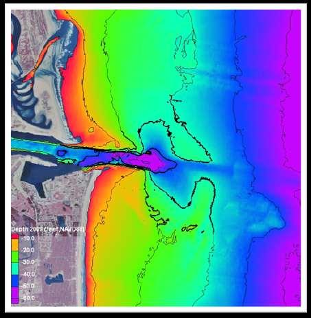
8 Field Measurements and Modeling PHYSICAL CHARACTERISTICS Water Velocities Levels and Flows Salinity Channel Shoaling Ship Wakes Coastal Shoreline Impacts 2009 May - July Bathymetric Survey MEASUREMENTS Water Level Salinity and Gages Suspended Sediment Sensors Acoustic Doppler Velocity and Flow Meters Measurement Plan Wave Gages Modeling Design Impacts Field Hydro- Forcing Ship Sim Design Salinity Shoaling Coastal Measurements Modeling
9 CoastalMeasurements CP-SL (1 mo) Velocity ADCP (3 mo/1yr) Hs, Tp, Dir WL Velocity Waves Hs=1m Tp=8sec Waves, WL, Currents Bathymetry (channel) Sediment (channel) North 0 Wave Height (meters) <=0.5 >0.5-1 >1-1.5 >1.5-2 >2-2.5 >2.5 Currents ADCP (6 mo) Velocity 270 Frequency 0% 5% 10% 15% 20% 25% JAX ODMDS ADCP
")

10 Sediment Characteristics 2007 Vibracores Distribution (2010) 75-60% fine sand 15 % med/cor % silt/clay Ebb Shoal D to 0.25 mm
11 Storm Event Extratropical Storm Events Date Max Hs Max Vbtm Duration Max Vbtm above 35 cm/s (m) (cm/s) (days) 1 Sep, 10-15, Nov, 2-9, Nov, 18-25, Jan, 16-22, Mar 29-Apr 4, Apr 19-24, May 5-13, May 29-Jun 5, JAX ODMDS ADCP ExtraTrop: 10-12/yr Tropical: 1 / 2yr 70 BtmVel_cm/s BtmVel_dir/10 DepAvgVel_cm /s DepAvgDir/10 SurVel_cm/s SurDir/10 Julian Days - November 19-24,2006
")
 Wave,")
12 JAX ADCP Wave WL #4 (pressure) JAX Gage (7m Depth) Wave, Current, WL
13 Modeling ADCIRC Depth Averaged Water level & Current Boundary Conditions Nov 2006, May July 2009 (complete) Coastal Modeling System (CMS) Channel Shoaling Rates (Preliminary) Sediment budgets & sediment transport for coastal shoreline GenCade Long Term Morphology (start 2011)
 Models Coastal water levels and")

14 ADCIRC - Salt Marsh, Tidal Creeks & IWW Advanced Circulation (ADCIRC) Models Coastal water levels and velocities Modeling Design Impacts Field Hydro- Forcing Ship Sim Design Salinity Shoaling Coastal Measurements Modeling


15 Local Model Applications - Regional ADCIRC Boundary Conditions Tidal and Meteorologic o Channel Design o Salinity o Coastal Modeling Design Impacts Field Hydro- Forcing Ship Sim Design Salinity Shoaling Coastal Measurements Modeling
 Fernandina Beach ODMDS ADCP Jacksonville ODMDS ADCP")

16 Time Series Validated (in terms of elevations and velocities at two stations) Fernandina Beach ODMDS ADCP Jacksonville ODMDS ADCP Jacksonville ODMDS Elevations Modeling Design Impacts Field Hydro- Forcing Ship Sim Design Salinity Shoaling Coastal Measurements Modeling


17 Jacksonville ODMDS Velocity and Direction Modeling Design Impacts Field Hydro- Forcing Ship Sim Design Salinity Shoaling Coastal Measurements Modeling

18 St. Johns Inlet Evolution 1856 chart of the St. Johns River entrance


19 1959 St. Johns Inlet Evolution


20 CMS Modeling St. Johns River Inlet Coastal Modeling System Coupled wave, current, sediment transport and bottom change 2-D / 3-D 80 Storm Events Currents (cm/s) Julian Days - November 19-24,2006 Modeling Design Impacts Field Hydro- Forcing Ship Sim Design Salinity Shoaling Coastal Measurements Modeling


21 Project & Regional Scale CMS CMS-Flow grid 60K cells 150m 30m CMS-Flow Telescope grid 68K cells 400m 25m


22 Project Level CMS-Flow Tides & Current Falling Tide Ebb Current
23 CMS Tasks Calibrate, & Verify Hydrodynamics, Waves, Sediment Transport & Morphology 2D-Depth Averaged or 3D? Simulate 1 year storm climate Define Sediment Transport Pathways Calculate Sediment Transport Rate Channel Shoaling Rates Sediment Budget


24 Regional Sediment Management Plan Jacksonville Harbor Deepening Project Duval County Duval County SPP CMS - St. Augustine Inlet CMS - St. Johns River Inlet GenCade Long Term Morphology
25 Summary Jacksonville Harbor / Mayport Deepening Projects Project & Regional Sediment Management Perspectives Modeling Tools ADCIRC Coastal Modeling System (CMS) GenCade
26 Thank You!
ERDC Update SAD Regional Management Board
 ERDC Update SAD Regional Management Board José E. Sanchez, P.E., SES Director, Coastal and Hydraulics Laboratory Engineer Research and Development Center 14FEB17 Overview of R&D Activities in AOR Cross
Savannah Harbor Expansion Project
 Savannah Harbor Expansion Project Evaluation of Hurricane Surge Impacts with Proposed Mitigation Plan December 2007 Introduction This report summarizes the results of hurricane surge impacts with implementation
WIND EFFECTS ON CHEMICAL SPILL IN ST ANDREW BAY SYSTEM
 WIND EFFECTS ON CHEMICAL SPILL IN ST ANDREW BAY SYSTEM PETER C. CHU, PATRICE PAULY Naval Postgraduate School, Monterey, CA93943 STEVEN D. HAEGER Naval Oceanographic Office, Stennis Space Center MATHEW
Nearshore Placement as a Regional Sediment Management Practice
 Nearshore Placement as a Regional Sediment Management Practice Katherine E. Brutsché, Ph.D. Brian C. McFall, Ph.D., P.E. Coastal and Hydraulics Laboratory US Army Engineer R&D Center ASBPA National Coastal
Coastal Inlets Research Program US Army Corps of Engineers Engineering Research and Development Center
 Coastal Inlets Research Program US Army Corps of Engineers Engineering Research and Development Center Site of Moriches Inlet Nov. 1951 Julie Dean Rosati and Nicholas C. Kraus, CIRP Program Manager Shinnecock
Morphological Modeling of Inlets and Adjacent Shorelines on Engineering Timescales
 CB&I Morphological Modeling of Inlets and Adjacent Shorelines on Engineering Timescales Challenges and Model Improvements based on Recent Studies Dobrochinski, J.P.H.; Benedet, L.; Signorin, M.; Pierro,
Mark H. Horwitz Ping Wang PhD Coastal Research Laboratory, School of Geosciences University of South Florida
 Mark H. Horwitz Ping Wang PhD Coastal Research Laboratory, School of Geosciences University of South Florida American Shore & Beach Preservation Association 2015 National Coastal Conference, New Orleans,
ABSTRACT. Keywords: Brunswick, dredged material, nearshore placement, PTM, sediment transport INTRODUCTION
 APPLICATION OF THE PARTICLE TRACKING MODEL TO PREDICT FAR-FIELD FATE OF SEDIMENT SUSPENDED BY NEARSHORE DREDGING AND PLACEMENT, BRUNSWICK GA Joseph Z. Gailani 1, Tahirih C. Lackey 1, and S. Jarrell Smith
Regional Sediment Management
 Regional Sediment Management Linda S. Lillycrop Program Manager Coastal Engineer US Army Engineer Research and Development Center Coastal and Hydraulics Laboratory Q AVG Coastal Resilience: The Environmental,
Decline of Lake Michigan-Huron Levels Caused by Erosion of the St. Clair River
 Decline of Lake Michigan-Huron Levels Caused by Erosion of the St. Clair River W.F. & Associates Coastal Engineers (in association with Frank Quinn) April 13, 2005 Outline Problem Definition Understanding
INFLUENCE OF INLET / SHOAL COMPLEX ON ADJACENT SHORELINES VIA INLET SINK METHOD
 INFLUENCE OF INLET / SHOAL COMPLEX ON ADJACENT SHORELINES VIA INLET SINK METHOD Kelly R. Legault, Ph.D., P.E. 1, Tanya M. Beck 2 and Jason A. Engle, P.E. 3 The region of influence of the inlet on the adjacent
Stream Discharge and the Water Budget
 Regents Earth Science Unit 6: Water Cycle & Climate Name: Lab # Stream Discharge and the Water Budget Introduction: The United States Geological Survey (USGS) measures and publishes values for the daily
Donald K. Stauble and Bill Birkemeier Coastal and Hydraulics Laboratory US Army Corps of Engineers
 Donald K. Stauble and Bill Birkemeier Coastal and Hydraulics Laboratory US Army Corps of Engineers Define the Problem Navigation Shore Protection Environmental Political So what is the problem? Management
Regional Sediment Management at East Rockaway Inlet, NY, Utilizing the USACE Coastal Modeling System
 Regional Sediment Management at East Rockaway Inlet, NY, Utilizing the USACE Coastal Modeling System by US Army Engineer District, New York PURPOSE: This Coastal and Hydraulics Engineering Technical Note
Annual transport rates at two locations on the fore-slope.
 Sediment Transport by Currents Fore-slope Sediment transport rates and sediment concentrations were computed from the hydrodynamic model runs as well as from direct measurements of current velocities at
Coastal and Hydraulics Laboratory
 ERDC/CHL TR-17-7 Regional Sediment Management (RSM) Program Charleston Harbor, SC, Regional Sediment Management Study; Beneficial Use of Dredged Material through Nearshore Placement Layla R. Kashlan, Sara
ENGINEERING APPROACHES TO SHORELINE PLACEMENT FROM COAST TO COAST
 ENGINEERING APPROACHES TO SHORELINE PLACEMENT FROM COAST TO COAST 237 237 237 217 217 217 200 200 200 0 0 0 163 163 163 131 132 122 80 119 27 252 174.59 83 36 118 110 135 120 112 92 56 62 102 130 Comparing
Creating a Bathymetric Database & Datum Conversion
 Creating a Bathymetric Database & Datum Conversion Mitchell Brown Civil Engineering Technician Mitchell.E.Brown@erdc.dren.mil June 11, 2012 US Army Corps of Engineers BUILDING STRONG Introduction to Bathymetric
MISSISSIPPI COASTAL IMPROVEMENTS
 MISSISSIPPI COASTAL IMPROVEMENTS PROGRAM (MsCIP) Comprehensive Barrier 237 27 200 237 27 200 Island 237 Restoration 27 200 Plan 80 9 27 252 74.59 255 255 255 0 0 0 63 63 63 3 32 22 239 65 53 0 35 20 2
SUPPLEMENTAL ENVIRONMENTAL ASSESSMENT AND FINDING OF NO SIGNIFICANT IMPACT
 January 2018 SUPPLEMENTAL ENVIRONMENTAL ASSESSMENT AND FINDING OF NO SIGNIFICANT IMPACT REVIEW OF RECENT STORM EVENTS AND FLOODING JACKSONVILLE HARBOR NAVIGATION PROJECT DUVAL COUNTY, FLORIDA U.S. Army
Appendix G.19 Hatch Report Pacific NorthWest LNG Lelu Island LNG Maintenance Dredging at the Materials Offloading Facility
 Appendix G.19 Hatch Report Pacific NorthWest LNG Lelu Island LNG Maintenance Dredging at the Materials Offloading Facility Project Memo H345670 To: Capt. David Kyle From: O. Sayao/L. Absalonsen December
COASTAL DATA APPLICATION
 2015 Coastal GeoTools Proactive By Design. Our Company Commitment COASTAL DATA APPLICATION Projecting Future Coastal Flood Risk for Massachusetts Bay Bin Wang, Tianyi Liu, Daniel Stapleton & Michael Mobile
Phase II Storm Surge Analysis
 Phase II Storm Surge Analysis Post 45 Project, Charleston, SC Prepared for: USACE Charleston District Charleston, SC Prepared by: Water Environment Consultants Mount Pleasant, SC October 21, 2016 Table
Pinellas, Manatee, and Sarasota Counties, Florida; Regional Sediment Budget
 Pinellas, Manatee, and Sarasota Counties, Florida; Regional Sediment Budget by Kelly R. Legault and Ashley E. Frey PURPOSE: This U.S. Army Corps of Engineers (USACE) Regional Sediment Management Technical
Location: Jacksonville, FL December 11, 2012
 Technical Update Meeting Northeast Florida Surge Study Location: Jacksonville, FL December 11, 2012 Agenda 2:00 2:15 Welcome/Introductions Tucker Mahoney, FEMA Region IV Michael DelCharco, BakerAECOM 2:15
Lu, S., P. Craig, C. Wallen, Z. Liu, A. Stoddard, W. McAnnally and E. Maak. Dynamic Solutions, Knoxville, TN USACOE, Sacramento District
 An Extended-Delta Hydrodynamic Model Framework for Sea Level Rise Analysis to Support Resource Management Planning for the Sacramento-San Joaquin River Delta Lu, S., P. Craig, C. Wallen, Z. Liu, A. Stoddard,
Regional Sediment Management: The Long Island Coastal Planning Project
 Regional Sediment Management: The Long Island Coastal Planning Project Lynn M. Bocamazo Senior Coastal Engineer USACE-New York District 22 September 2009 US Army Corps of Engineers Outline Project Location
Coastal and Hydraulics Laboratory
 ERDC/CHL TR-12-14 Coastal Inlets Research Program Optimization of Ebb Shoal Mining and Beach Nourishment at St. Johns County, St. Augustine Inlet, Florida Report 3 Tanya M. Beck and Kelly Legault August
Holderness Erosion and Evolution of the Spurn Peninsula
 Holderness Erosion and Evolution of the Spurn Peninsula Prof. Ken Pye and Dr. Simon Blott Kenneth Pye Associates Ltd. Outline of the Presentation Overview of historical erosion trends Effects of coast
Linking Inlet Hydrodynamics and Morphologic Response at Oregon Inlet, NC
 Linking Inlet Hydrodynamics and Morphologic Response at Oregon Inlet, NC Prepared for: Sharon Ahlers Engineering Communications Program Cornell University Prepared by: Justin Vandever School of Civil and
Sessom Creek Sand Bar Removal HCP Task 5.4.6
 Sessom Creek Sand Bar Removal HCP Task 5.4.6 Prepared by: Dr. Thomas Hardy Texas State University Dr. Nolan Raphelt Texas Water Development Board January 6, 2013 DRAFT 1 Introduction The confluence of
SAVANNAH HARBOR EXPANSION BANK EROSION STUDY UPDATE
 CESAS-EN-GS SAVANNAH HARBOR EXPANSION BANK EROSION STUDY UPDATE GEOTECHNICAL AND HTRW BRANCH SOILS SECTION CITY FRONT, BIGHT SECTION, FORT PULASKI & NORTH TYBEE ISLAND GEORGIA 23 June 2011 CESAW-TS-EG
MODELING OF EROSION CONTROL ALTERNATIVES AT STUMP PASS, CHARLOTTE COUNTY
 2014 NATIONAL CONFERENCE ON BEACH PRESERVATION TECHNOLOGY FEBRUARY 13, 2014 MODELING OF EROSION CONTROL ALTERNATIVES AT STUMP PASS, CHARLOTTE COUNTY 1 VADIM ALYMOV, PH.D. 2 CHUCK MOPPS 3 MICHAEL POFF,
A SEDIMENT BUDGET ANALYSIS AND MANAGEMENT STRATEGY FOR FORT PIERCE INLET, FL
 A SEDIMENT BUDGET ANALYSIS AND MANAGEMENT STRATEGY FOR FORT PIERCE INLET, FL By Elba Rodriguez and Robert G. Dean Department of Civil and Coastal Engineering University of Florida Gainesville, FL 32611,
Webinar on PTM with CMS
 Webinar on PTM with CMS Honghai Li Research Physical Scientist Mitchell E. Brown Civil Engineering Technician Engineer Research and Development Center CMS December 4, 2013 US Army Corps of Engineers BUILDING
ST. JOHNS COUNTY, FLORIDA South Ponte Vedra Beach, Vilano Beach, and Summer Haven Reaches
 ST. JOHNS COUNTY, FLORIDA South Ponte Vedra Beach, Vilano Beach, and Summer Haven Reaches COASTAL STORM RISK MANAGEMENT PROJECT DRAFT INTEGRATED FEASIBILITY STUDY AND ENVIRONMENTAL ASSESSMENT APPENDIX
The U.S. Army Corps of Engineers Philadelphia District
 The U.S. Army Corps of Engineers Philadelphia District The Atlantic Coast of New Jersey Regional Sediment Budget 1986-2003 Cape May Point to Manasquan Inlet Final Report March 2006 The Atlantic Coast of
An overview of USGS Hurricane Sandy Supplemental Studies along the Delmarva Peninsula
 An overview of USGS Hurricane Sandy Supplemental Studies along the Delmarva Peninsula Neil K. Ganju, Laura L. Brothers, Nathaniel G. Plant, Christopher G. Smith, E. Robert Thieler Coastal and Marine Geology
Remaining Capacity in Great Lakes Reservoirs
 US Army Corps of Engineers Detroit District Remaining Capacity in Great Lakes Reservoirs Storage Capacity Behind Great Lakes Dams Field Data and Modeling Motivation for project Project overview Data and
Primer on Coastal Erosion And Habitat Creation
 2 nd Regional Conference Dredging, Beach Nourishment & Bird Conservation Primer on Coastal Erosion And Habitat Creation Timothy Kana Ph.D Source: Newsday 1962 Photo by Kelsey Aerials 1978 Source: U Mass
Appendix G.18 Hatch Report Pacific NorthWest LNG Lelu Island LNG Potential Impacts of the Marine Structures on the Hydrodynamics and Sedimentation
 Appendix G.18 Hatch Report Pacific NorthWest LNG Lelu Island LNG Potential Impacts of the Marine Structures on the Hydrodynamics and Sedimentation Patterns Project Memo H345670 To: Capt. David Kyle From:
RE: Inadequacy of December 2017 Draft Supplemental Environmental Assessment Review of Recent Storm Events and Flooding
 December 29, 2017 U.S. Corps of Engineers Jacksonville District ATTN: Paul Stodola 701 San Marco Boulevard Jacksonville, Florida 32207-8175 TO: FROM: Paul Stodola U.S. Corps of Engineers Jacksonville District
Coastal Sediment Properties and Longshore Sediment Transport
 Coastal Sediment Properties and Longshore Sediment Transport Julie Rosati Julie.D.Rosati@erdc.usace.army.mil 601-634-3005 Coastal Planning Course Lesson #8 Tuesday 8:00-9:00 am CEM III-1, III-2 1. Coastal
Georgia and Northeast Florida Coastal Storm Surge and Mapping Study: Continued Progress Amid Challenges
 Georgia and Northeast Florida Coastal Storm Surge and Mapping Study: Continued Progress Amid Challenges Presented by Christopher Bender, Ph.D., P.E., D.CE June 12, 2013 Presentation Overview FEMA risk
GenCade. Combining and Extending the GENESIS and Cascade Models for Planning and Design in a Regional Sediment Management Framework
 GenCade Combining and Extending the GENESIS and Cascade Models for Planning and Design in a Regional Sediment Management Framework G Presented by Nicholas C. Kraus For the GenCade Development Team Ken
Linking Sediment Transport in the Hudson from the Tidal River to the Estuary
 Linking Sediment Transport in the Hudson from the Tidal River to the Estuary Or, what happened to all the mud from Irene? David Ralston, Rocky Geyer, John Warner, Gary Wall Hudson River Foundation seminar
EAST PASS UP-DATE SUMMARY OF FINDINGS REPORT and INLET MANAGEMENT IMPLEMENTATION PLAN
 EAST PASS 2013 UP-DATE SUMMARY OF FINDINGS REPORT and INLET MANAGEMENT IMPLEMENTATION PLAN Introduction On June 8, 2000, the Florida Department of Environmental Protection adopted the East Pass Inlet Management
ΛTKINS. Applications of Regional Sediment Management Concepts in Texas Estuarine Restoration Projects. Riparian Workshop Fort Worth, October 17, 2012
 Juan C Moya, PhD., PG Coastal Planning and Restoration Applications of Regional Sediment Management Concepts in Texas Estuarine Restoration Projects Riparian Workshop Fort Worth, October 17, 2012 West
EFFECTIVE TROPICAL CYCLONE WARNING IN BANGLADESH
 Country Report of Bangladesh On EFFECTIVE TROPICAL CYCLONE WARNING IN BANGLADESH Presented At JMA/WMO WORKSHOP ON EFFECTIVE TROPICAL CYCLONE WARNING IN SOUTHEAST ASIA Tokyo, Japan,11-14 March 2014 By Sayeed
Appendix O. Sediment Transport Modelling Technical Memorandum
 Appendix O Sediment Transport Modelling Technical Memorandum w w w. b a i r d. c o m Baird o c e a n s engineering l a k e s design r i v e r s science w a t e r s h e d s construction Final Report Don
Amelia Island, Nassau County, FL Marine Geological Field Investigation for Offshore Geologic Model Support
 Amelia Island, Nassau County, FL for Offshore Geologic Model Support BOEM Notice of Scientific Research NA15 001 Submitted to: Bureau of Ocean Energy Management (BOEM) Florida Department of Environmental
Physical Processes: What have we learned about Florida Bay in the past five years, and how is that useful to CERP planning and SFER management?
 Physical Processes: What have we learned about Florida Bay in the past five years, and how is that useful to CERP planning and SFER management? Peter B. Ortner, UM/RSMAS/CIMAS Modeling Progress Statistical
Development, Testing and Application of the Multi-Block LTFATE Hydrodynamic and Sediment Transport Model
 Development, Testing and Application of the Multi-Block LTFATE Hydrodynamic and Sediment Transport Model Earl Hayter Environmental Lab October 25, 2012 LTFATE Multi-Block Hydrodynamic, Water Quality and
Predicting the Evolution of Tidal Channels in Muddy Coastlines
 Predicting the Evolution of Tidal Channels in Muddy Coastlines Sergio Fagherazzi Address Department of Earth Sciences and Center for Computational Science, Boston University, Boston MA 02215 Phone: 617-353-2092
Coastal and Hydraulics Laboratory
 ERDC/CHL TR-05-6 Texas City Ship Channel Deepening Study, Hydrodynamic Model Lisa M. Lee, Jennifer N. Tate, and R. C. Berger August 2005 Coastal and Hydraulics Laboratory Approved for public release; distribution
Anderson-Ketron PSDDA Disposal Site Fate and Transport Modeling
 Pierce County Washington Anderson-Ketron PSDDA Disposal Site Fate and Transport Modeling Design Memorandum September 2014 Table of Contents 1 Introduction... 3 1.1 Purpose and Scope... 3 1.2 Project Description:
Development and application of demonstration MIKE 21C morphological model for a bend in Mekong River
 Development and application of demonstration MIKE 21C morphological model for a bend in Mekong River September 2015 0 Table of Contents 1. Introduction... 2 2. Data collection... 3 2.1 Additional data...
The Sediment Budget Calculator: A Webtool to Develop a Family of Viable Inlet and Adjacent Beach Sediment Budget Solutions
 The Sediment Budget Calculator: A Webtool to Develop a Family of Viable Inlet and Adjacent Beach Sediment Budget Solutions by Julie Dean Rosati, Charles A. Sumner, and Derek A. Wilson PURPOSE: This Coastal
Appendix I. Dredged Volume Estimates. Draft Contractor Document: Subject to Continuing Agency Review
 Appendix I Dredged Volume Estimates Draft Contractor Document: Subject to Continuing Agency Review Interoffice Correspondence Date: April 6, 2007 To: L. Bossi (WHI) Copy: S. Thompson (WHI), B. Fidler (NNJ)
Sediment Traps. CAG Meeting May 21, 2012
 Sediment Traps CAG Meeting May 21, 2012 Agenda Background Fundamentals of Sediment Transport Sediment Trap Existing Information Next Steps 2 The Site Saginaw River 22 mile river beginning at confluence
ANALYSIS OF FLOW CONDITIONS AT THE IHNC-GIWW SECTOR GATE
 ANALYSIS OF FLOW CONDITIONS AT THE IHNC-GIWW SECTOR GATE SLFPA-E October 2016 Motivation SLFPA-E has observed high velocities within the opening of the GIWW sector gate at the surge barrier. Concern about
Coastal and Hydraulics Laboratory
 ERDC/CHL TR-09-6 Houston-Galveston Navigation Channels, Texas Project Navigation Channel Sedimentation Study, Phase 2 Plan Simulations Jennifer N. Tate and Cassandra G. Ross August 2009 Coastal and Hydraulics
COASTAL SEDIMENT BUDGET FOR JUPITER INLET, FLORIDA
 COASTAL SEDIMENT BUDGET FOR JUPITER INLET, FLORIDA By KRISTEN MARIE ODRONIEC A THESIS PRESENTED TO THE GRADUATE SCHOOL OF THE UNIVERSITY OF FLORIDA IN PARTIAL FULFILLMENT OF THE REQUIREMENTS FOR THE DEGREE
MORPHODYNAMIC PROCESSES IN ESTUARIES COMPARISON OF MARINE AND LIMNIC TIDAL FLATS
 MORPHODYNAMIC PROCESSES IN ESTUARIES COMPARISON OF MARINE AND LIMNIC TIDAL FLATS Thorsten Albers 1, Dagmar Much 2, Nino Ohle 2, Nicole von Lieberman 1, Eva Falke 1 Tidal flat areas in estuaries are affected
Geology Setting Management Options Management Structure
 Geology Setting Management Options Management Structure WFF = Wallops Flight Facility LST = Longshore sediment transport SLR = Sea level rise September 29, 2015 Accomack County/Accomack Northampton County
Del Mar Sediment Management Study
 Del Mar Sediment Management Study Shoreline Preservation Working Group, June 7, 2018 Lindsey Sheehan Current work in Del Mar 2016 Sea-Level Rise Vulnerability Assessment 2018 Adaptation Plan 2018 Sediment
The use of MIKE21 to study the. barrier beach system of Inner Dingle Bay, Co. Kerry, Ireland. Dr. Michael O Shea Malachy Walsh and Partners
 The use of MIKE21 to study the morphodynamic evolution of the mid-bay barrier beach system of Inner Dingle Bay, Co. Kerry, Ireland Dr. Michael O Shea Malachy Walsh and Partners Contents Why Study Morphodynamics
Field and Numerical Study of the Columbia River Mouth
 DISTRIBUTION STATEMENT A. Approved for public release; distribution is unlimited. Field and Numerical Study of the Columbia River Mouth Guy Gelfenbaum 400 Natural Bridges Dr. Santa Cruz, CA 95060 Phone:
GSA DATA REPOSITORY
 GSA DATA REPOSITORY 2009206 Miner et al. Supplemental Material Bathymetric Survey Methods The bathymetric data for the area were gathered using a single-beam bathymetric survey rig mounted aboard a 21-foot
ROBERTS BANK CONTAINER EXPANSION COASTAL GEOMORPHOLOGY STUDY. Appendix B
 ROBERTS BANK CONTAINER EXPANSION COASTAL GEOMORPHOLOGY STUDY Appendix B Prepared for: Vancouver Port Authority Prepared by: northwest hydraulic consultants 30 Gostick Place North Vancouver, B. C. V7M 3G2
PTM: A Lagrangian Particle Tracking Model. Joseph Gailani
 PTM: A Lagrangian Particle Tracking Model Joseph Gailani Joe.Z.Gailani@usace.army.mil OUTLINE Motivation for sediment/constituent modeling system Objectives of modeling system Description of PTM PTM Example
Modeling Nearshore Waves for Hurricane Katrina
 Modeling Nearshore Waves for Hurricane Katrina Jane McKee Smith US Army Engineer Research & Development Center Coastal and Hydraulics Laboratory Outline Introduction Modeling Approach Hurricane Katrina
N. von Lieberman 1 and T. Albers 2
 MORPHODYNAMIC DEVELOPMENT OF TIDAL FLATS by N. von Lieberman 1 and T. Albers 2 ABSTRACT The tidal flats of the German North Sea coast are affected by intense morphodynamics. Especially in the mouths of
ST. JOHNS COUNTY, FLORIDA
 ST. JOHNS COUNTY, FLORIDA South onte Vedra Beach, Vilano Beach, and Summer Haven Reaches COASTAL STORM RISK MANAGEMENT ROJECT DRAFT INTEGRATED FEASIBILITY STUDY AND ENVIRONMENTAL ASSESSMENT AENDIX D Geotechnical
Planning for the Future of Humboldt Bay: Sea Level Rise, Sediment Management, Sand Spits and Salt Marshes. Joel Gerwein
 Planning for the Future of Humboldt Bay: Sea Level Rise, Sediment Management, Sand Spits and Salt Marshes Joel Gerwein Introduction to Humboldt Bay Setting Economy, community, and environment Sediment
Process-based Long Term Morphological Modelling the present state-of-the-art and the way ahead. Dirk-Jan Walstra
 Process-based Long Term Morphological Modelling the present state-of-the-art and the way ahead Dirk-Jan Walstra Deltares Delft Hydraulics Delft University of Technology Les littoraux à l heure du changement
Redwood City Harbor, California, Navigation Improvement Feasibility Study. Appendix D. Geotechnical Engineering. DRAFT April 2015
 1 Redwood City Harbor, California, Navigation Improvement Feasibility Study Appendix D Geotechnical Engineering DRAFT April 2015 2 Contents 1 Purposes of Report... 3 2 Background... 3 3 References and
Analysis of Tides and Storm Surge from Observational Records in the Delaware Inland Bays
 Analysis of Tides and Storm Surge from Observational Records in the Delaware Inland Bays John Callahan Delaware Geological Survey Coastal GeoTools Conference March 30 April 2, 2015 Charleston, SC Outline
Whiskey Island Marsh Creation Rolling with the Punches
 Whiskey Island Marsh Creation Rolling with the Punches Santiago Alfageme, M&N Jerry Carroll, LADNR Brad Miller, LADNR Project Location Historic Island Retreat Previous Restoration Project Whiskey Island
Jun Cheng School of Geosciences, University of South Florida 4202 E. Fowler Ave., NES 117, Tampa, FL 33620
 EDUCATION Jun Cheng 4202 E. Fowler Ave., NES 117, Tampa, FL 33620 Phone: 813-974-2759 Email: jun@mail.usf.ed University of South Florida (Tampa, FL) Ph.D. in Geology, 2015 Dissertation: Multiple Scale
South Florida Coastal Storm Surge and Mapping Study
 South Florida Coastal Storm Surge and Mapping Study Presented by Christopher Bender, Ph.D., P.E., D.CE June 2, 2015 Presentation Overview FEMA risk studies outline Overview South Florida surge study Work
ENGINEERING WITH NATURE: NEARSHORE BERM PLACEMENTS AT FORT MYERS BEACH AND PERDIDO KEY, FLORIDA, USA
 1 ENGINEERING WITH NATURE: NEARSHORE BERM PLACEMENTS AT FORT MYERS BEACH AND PERDIDO KEY, FLORIDA, USA KATHERINE E. BRUTSCHÉ 1, PING WANG 2, JULIE D. ROSATI 1, CHERYL E. POLLOCK 1 1. U.S. Army Engineer
Assessment of the Hood River Delta Hood River, Oregon
 Assessment of the Hood River Delta Hood River, Oregon Pacific Northwest Waterways Association Annual Meeting October 13, 2010 Michael McElwee, Executive Director Port of Hood River Overview U.S. Army Corps
RESULTS FROM THE TEXAS COASTAL SEDIMENT SOURCES: A GENERAL EVALUATION STUDY
 RESULTS FROM THE TEXAS COASTAL SEDIMENT SOURCES: A GENERAL EVALUATION STUDY JUAN MOYA KELSEY CALVEZ CRIS WEBER ANTHONY RISKO *KEVIN FRENZEL FREESE AND NICHOLS, INC. COASTAL AND WATERWAYS GROUP OBJECTIVES
Illinois State Water Survey Division
 Illinois State Water Survey Division SURFACE WATER SECTION SWS Miscellaneous Publication 108 SEDIMENT YIELD AND ACCUMULATION IN THE LOWER CACHE RIVER by Misganaw Demissie Champaign, Illinois June 1989
West Galveston Bay Regional Sediment Management Plan (An Eco-geomorphologic Approach)
") West Galveston Bay Regional Sediment Management Plan (An Eco-geomorphologic Approach) Juan Moya, Matthew Mahoney and Mike Smith Restore America s Estuaries Conference Tampa, FL, October 23, 2012 Atkins
West Galveston Bay Regional Sediment Management Plan (An Eco-geomorphologic Approach) Juan Moya, Matthew Mahoney and Mike Smith Restore America s Estuaries Conference Tampa, FL, October 23, 2012 Atkins
High Resolution Numerical Models of Tidal Marshes in the Delaware Bay
 High Resolution Numerical Models of Tidal Marshes in the Delaware Bay Ramona Stammermann Dept. of Civil, Architectural & Environmental Engineering, Drexel University, Philadelphia, PA Michael Piasecki
Material Workshop. Galveston District 2012 Beneficial Use of Dredged. Material Workshop. Custodians of the Coast
 Galveston District 2012 Beneficial Use of Dredged Material Workshop Galveston District 2012 Beneficial Use of Dredged Material Workshop US Army Corps of Engineers BUILDING STRONG Welcome Opening Remarks
APPENDIX F SEDIMENT DEPOSITION AND HABITAT CONVERSION ANALYSIS
 APPENDIX F SEDIMENT DEPOSITION AND HABITAT CONVERSION ANALYSIS San Dieguito Lagoon W-19 Restoration Project Draft EIR March 2017 Appendices Introduction: The following is an analysis to provide the volume
SEDIMENT TRANSPORT IN RIVER MOUTH ESTUARY
 SEDIMENT TRANSPORT IN RIVER MOUTH ESTUARY Katsuhide YOKOYAMA, Dr.Eng. dredge Assistant Professor Department of Civil Engineering Tokyo Metropolitan University 1-1 Minami-Osawa Osawa, Hachioji,, Tokyo,
'Sand' Balance Approach. Assessing sediment budgets and transports using bathymetric data
 'Sand' Balance Approach Assessing sediment budgets and transports using bathymetric data Deltares, 2012 Contents 1 A sediment approach 1 1.1 Introduction 1 1.2 Dynamic stability of estuaries and management
IMPAC-T Progress report Variability of Sediment Discharge and Shoreline Change due to Global Warming
 IMPAC-T Progress report Variability of Sediment Discharge and Shoreline Change due to Global Warming SiBUC Research Group Researcher Butsawan Bidorn Water Resources Engineering Dept. Chulalongkorn University
Flow estimations through spillways under submerged tidal conditions
 Computational Methods and Experimental Measurements XIII 137 Flow estimations through spillways under submerged tidal conditions P. D. Scarlatos 1, M. Ansar 2 & Z. Chen 2 1 Department of Civil Engineering
DIVISION OF COASTAL MANAGEMENT TO STUDY CURRENT LONG-TERM EROSION RATES ADJACENT TO TERMINAL GROINS
 DIVISION OF COASTAL MANAGEMENT TO STUDY CURRENT LONG-TERM EROSION RATES ADJACENT TO TERMINAL GROINS North Carolina Department of Environmental Quality Division of Coastal Management February 22, 2018 N.
John Callahan (Delaware Geological Survey) Kevin Brinson, Daniel Leathers, Linden Wolf (Delaware Environmental Observing System)
 Kevin Brinson, Daniel Leathers, Linden Wolf (Delaware Environmental Observing System)") John Callahan (Delaware Geological Survey) Kevin Brinson, Daniel Leathers, Linden Wolf (Delaware Environmental Observing System) Delaware is extremely vulnerable to the impacts of coastal flooding Tropical
John Callahan (Delaware Geological Survey) Kevin Brinson, Daniel Leathers, Linden Wolf (Delaware Environmental Observing System) Delaware is extremely vulnerable to the impacts of coastal flooding Tropical
Predicting the Evolution of Tidal Channels in Muddy Coastlines
 Predicting the Evolution of Tidal Channels in Muddy Coastlines Sergio Fagherazzi Department of Earth Sciences and Center for Computational Science Boston University, Boston MA 02215 Phone: (617) 353-2092
SUWANNEE RIVER WATER MANAGEMENT DISTRICT 9225 CR 49 LIVE OAK FLORIDA DECEMBER 2015
 HYDRODYNAMIC MODEL DEVELOPMENT, CALIBRATION, AND MFL FLOW REDUCTION AND SEA LEVEL RISE SIMULATION FOR THE TIDAL PORTION OF THE ECONFINA RIVER ECONFINA RIVER, FLORIDA SUWANNEE RIVER WATER MANAGEMENT DISTRICT
GALVESTON BAY RSM Moving toward an Integrated, Cooperative, and Holistic Approach to Estuarine Sediments
 GALVESTON BAY RSM Moving toward an Integrated, Cooperative, and Holistic Approach to Estuarine Sediments RAE Conference 2010 Larry A. Wise Moffatt & Nichol RSM is a system-based approach for collaboratively
Regional-scale understanding of the geologic character and sand resources of the Atlantic inner continental shelf, Maine to Virginia
 Regional-scale understanding of the geologic character and sand resources of the Atlantic inner continental shelf, Maine to Virginia Workshop on Dredging, Beach Nourishment and Bird Conservation Atlantic
THE IMPORTANCE OF SCIENCE IN COASTAL RESTORATION IN LOUISIANA
 THE IMPORTANCE OF SCIENCE IN COASTAL RESTORATION IN LOUISIANA Barb Kleiss USACE, Mississippi Valley Division August 3, 2011 LCA S&T Office Authorized under WRDA 2007 Designed to address technical issues