Primer on Coastal Erosion And Habitat Creation
|
|
|
- Charles Cross
- 5 years ago
- Views:
Transcription

1 2 nd Regional Conference Dredging, Beach Nourishment & Bird Conservation Primer on Coastal Erosion And Habitat Creation Timothy Kana Ph.D Source: Newsday 1962 Photo by Kelsey Aerials 1978 Source: U Mass Coastal Research Group C o a s t a l S c i e n c e & E n g i n e e r i n g CS


2 Public Perceptions Coastal Erosion is: Myrtle Beach - Today Inevitable Expensive to Manage Only A Problem Where There is Development Low Tide High Tide 20-yr Cost To Restore & Maintain: $20/foot/year.


3 Fundamental Processes Scales of Change Barrier Island Evolution Erosion Signatures Implications For Wildlife Habitat Outline of Presentation Storm Surge Northeaster - Cape Cod Photo by Kelsey Aerial Photography
4 Frames of Reference The Coast Evolves as a Function of: Tectonic Setting Sea Level Position epoch scale Sea Level Fluctuation historical Sediment Supply Climate & Coastal Processes Waves Tides Currents Post-Storm Storm Time/Space Scales: >1 million yrs/ 100s kilometers (hor) ~100,000 yrs / ~100 meters (vert) ~10,000 yrs / ~ 10 meters All Time Scales Millenium To Decadal Processes That Mold & Shape The Coast From Year to Year Weeks to Months Hours to Days Unless The Time Scale of Interest Is Specified, There Will Always Be Confusion and Disagreement Regarding Coastal Erosion!


5 The Beach Cycle Tides & Storm Surges Control The Water Level - But Waves Do The Work! Photos Courtesy: U of Mass Coastal Research Group & U of South Carolina Coastal Research Division


6 What Is The Storm Erosion vs Long-term Erosion Rates Appropriate Erosion Rate And Time Period For Planning? Most developed shorelines are changing by less than 3 ft per year at decade to century time scales. Source: Dolan et al (1990).


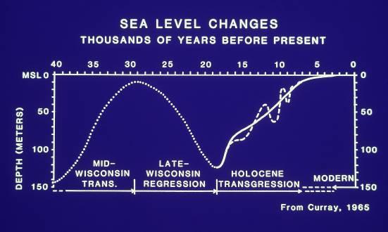
7 Sea level Rise As A Cause Of Erosion
8 Sea-Level Rise 1 Ft Per Century (20th Century Rate) = ~30 Feet Of Beach Recession, or = ~ 0.3 Ft/Year Erosion Rate Therefore, 2-3 Ft Per Century = ~ Ft/Year Erosion

9 Barrier Island Types Edingsville Beach SC Planter s Cottages Abandoned by 1893 Century Erosion Rates: ft/yr
10 Washover Barrier Island A A Low Sandy Island That Is Flooded Often By Storm Tides & Waves Typical Dimensions Barrier Island Assume Average Erosion Rate = 5 ft/yr
11 Washover Barrier Island Years Erosion The Beaches Are Moving! Kaufman & Pilkey, 5 ft/yr Volume Erosion Rate: ~5 CY/ft/yr 50-Yr Loss: ~250 CY/ft 100-Yr Loss: ~500 CY/ft Or, ~30 truckloads of sand per ft of beach

12 Core Banks NC ~50 Year Erosion Rate: 5 to 15 Ft/yr Source: NC Div of Coastal Management (May 2003)


13 Are Washover Beaches Typical? Bogue Banks NC Western Fire Island NY
14 Beach Ridge Barrier Island Many Barrier Islands Are >1000 ft - wide! Barrier Island Assume Erosion Rate = 2 ft/yr
15 Beach Ridge Barrier Island Yrs 2 ft/yr Volume Erosion Rate: ~2 CY/ft/yr 50-Yr Loss: ~100 CY/ft 100-Yr Loss: ~200 CY/ft Or, ~12 truckloads of sand per ft of beach
16 Barrier Island Sections Common Developed Barrier Island Present Cost to Maintain 2 CY/ft/yr Erosion Rate = ~$10-16/ft/yr Washover Barrier 10 CY/ft/yr Erosion Rate = ~$50-80/ft/yr

17 Directions Sand Moves How Do We Know This? Photos by T.W. Kana
18 Western Fire Island Evolution Oak Beach Great South Bay Sore Thumb Fire Island Inlet 1834 Kismet Democrat Point Accretion Fillet Net Longshore Transport N Atlantic Ocean Scale - Miles Based On USACE 1958; Saville 1960
19 Spit Growth & Rotation Megascale Geomorphic Model No Rotation With Rotation Marsh-filled Lagoon Washovers Infrequent Open Lagoon Washovers Common Bulge eg.. Kiawah Island, SC Cape Litchfield, SC eg.. Western Fire Island, NY Garden City, SC


20 Spit Growth & Rotation Capt Sams Inlet SC North Inlet SC Debordieu Colony Seabrook Island Earlier Inlet Earlier Inlet Kiawah Island Present Inlet Which Spit Is Likely To Create The Most Habitat for Least Terns?


21 Dewees Inlet SC Inlet Sand Trapping & Bypassing Severe Erosion 0.4 Miles Severe Erosion

22 Shoal Bypassing at Kiawah Island 1970s to 1980s Shoal Bypassing: The release of sand bars from inlet deltas due to changes in channel position and excess sediment supply. Bypass Volumes: ~ 1 million cy 1986 This is why some beaches are healthy at century time scales!


23 Kiawah Island Dec 1998 Source: Miles Hayes (USC)

24 Shoal Bypassing at Kiawah Island 1990s Bypass Volumes: > 5 million cy Focussed Erosion


25 Type of Habitat Some Threatened Birds Like 1860s Beach 1960s Beach 2003 Images Dynamic Shoreline Unstable Large Sand Surplus Nearby Food Source No Predators


26 Feb 1983 Captain Sams Inlet Relocation New Channel ~150,000 cy to move channel ~1,500,000 cy added to Seabrook Cost: $300,000 Sep 1983 May 1984 Feb 1986
 1983 1987 Original dunes 5.2 1.6 Closure dike (dune) 0.9 New dunes (by accretion) 0.8 3.")

27 1983 Inlet Relocation - Habitats ~1 km Habitat Changes Habitat Total Area Type ( ) Original dunes Closure dike (dune) 0.9 New dunes (by accretion) Washover terraces New beach 10.3 Intertidal bars Subtidal (lagoon) Totals Hectare Marsh New Barrier Beach 1983 Closure Dike *Source: Baca & Lankford, 1987


28 Habitats Created At Decadal Scales Why Salt Marsh In Some Areas & Open Water Elsewhere?
 Building Blocks: Barrier Beach Wetland Habitats function of - land elevation (w/res Sea Level) - flooding frequency (w/res")
29 Controls On Tidal Wetland Formation Elevation (ft NGVD) Predicted Tide And Range Of Low Marsh Predicted Tide Surveyed Range Of Low Marsh Typical Tide Record (Days) Building Blocks: Barrier Beach Wetland Habitats function of - land elevation (w/res Sea Level) - flooding frequency (w/res Tide)


30 EPA Case Studies Flooding frequency: - High Marsh ~1% - Low Marsh ~ 10% % Areal Coverage Source: Kana & Baca 1988

31 Summary Coastal Erosion Operates At A Continuum of Scales The Present Coast Is Dependent On A Balance Between SLR & Sediment Supply There Are Many Site-specific Signatures Of Erosion Conflicts Regarding Shoreline Management Arise Because Of Differing Time Frames Of Reference It Is Possible To Create Habitat Artificially And Thereby Accelerate or Decelerate Natural Processes In Some Cases, If Done With Care!
Bob Van Dolah. Marine Resources Research Institute South Carolina Department of Natural Resources
 Bob Van Dolah Marine Resources Research Institute South Carolina Department of Natural Resources Shoreline Change Will Occur! On our front beaches where it is not easy to retreat Shoreline Change Will
Sea-level Rise on Cape Cod: How Vulnerable Are We? Rob Thieler U.S. Geological Survey Woods Hole, MA
 Sea-level Rise on Cape Cod: How Vulnerable Are We? Rob Thieler U.S. Geological Survey Woods Hole, MA Outline Sea-level and coastal processes Past sea-level change Predictions for the future Coastal responses
Geology Setting Management Options Management Structure
 Geology Setting Management Options Management Structure WFF = Wallops Flight Facility LST = Longshore sediment transport SLR = Sea level rise September 29, 2015 Accomack County/Accomack Northampton County
Coastal Inlets Research Program US Army Corps of Engineers Engineering Research and Development Center
 Coastal Inlets Research Program US Army Corps of Engineers Engineering Research and Development Center Site of Moriches Inlet Nov. 1951 Julie Dean Rosati and Nicholas C. Kraus, CIRP Program Manager Shinnecock
Whiskey Island Marsh Creation Rolling with the Punches
 Whiskey Island Marsh Creation Rolling with the Punches Santiago Alfageme, M&N Jerry Carroll, LADNR Brad Miller, LADNR Project Location Historic Island Retreat Previous Restoration Project Whiskey Island
Sediment Management in the Coastal Bays
 Sediment Management in the Coastal Bays Introduction Need for ecosystem view of sediment management in Coastal Bays Island loss and restoration Navigation needs Habitat Trade offs Living Shoreline Requirements
The U.S. Army Corps of Engineers Philadelphia District
 The U.S. Army Corps of Engineers Philadelphia District The Atlantic Coast of New Jersey Regional Sediment Budget 1986-2003 Cape May Point to Manasquan Inlet Final Report March 2006 The Atlantic Coast of
DIVISION OF COASTAL MANAGEMENT TO STUDY CURRENT LONG-TERM EROSION RATES ADJACENT TO TERMINAL GROINS
 DIVISION OF COASTAL MANAGEMENT TO STUDY CURRENT LONG-TERM EROSION RATES ADJACENT TO TERMINAL GROINS North Carolina Department of Environmental Quality Division of Coastal Management February 22, 2018 N.
Coastal Processes 101 & The Regs. Greg Berman (Woods Hole Sea Grant & Cape Cod Cooperative Extension)
") Coastal Processes 101 & The Regs Greg Berman (Woods Hole Sea Grant & Cape Cod Cooperative Extension) March 26, 2019 Coastal Processes 101 & The Regs Outline: ~15 min talk Coastal Processes What is Erosion?
Coastal Processes 101 & The Regs Greg Berman (Woods Hole Sea Grant & Cape Cod Cooperative Extension) March 26, 2019 Coastal Processes 101 & The Regs Outline: ~15 min talk Coastal Processes What is Erosion?
Planning for the Future of Humboldt Bay: Sea Level Rise, Sediment Management, Sand Spits and Salt Marshes. Joel Gerwein
 Planning for the Future of Humboldt Bay: Sea Level Rise, Sediment Management, Sand Spits and Salt Marshes Joel Gerwein Introduction to Humboldt Bay Setting Economy, community, and environment Sediment
The Coast: Beaches and Shoreline Processes
 1 2 3 4 5 6 7 8 9 The Coast: es and Shoreline Processes Trujillo & Thurman, Chapter 10 Oceanography 101 Chapter Objectives Recognize the various landforms characteristic of beaches and coastal regions.
GenCade. Combining and Extending the GENESIS and Cascade Models for Planning and Design in a Regional Sediment Management Framework
 GenCade Combining and Extending the GENESIS and Cascade Models for Planning and Design in a Regional Sediment Management Framework G Presented by Nicholas C. Kraus For the GenCade Development Team Ken
The Coast: Beaches and Shoreline Processes Trujillo & Thurman, Chapter 10
 The Coast: es and Shoreline Processes Trujillo & Thurman, Chapter 10 Oceanography 101 Chapter Objectives Recognize the various landforms characteristic of beaches and coastal regions. Identify seasonal
Importance of Understanding Coastal Landforms
 Importance of Understanding Coastal Landforms Costa Concordia Shipwreck, Isola del Giglio, Italy Depositional Coastal Landforms Can interpret landforms in light of geomorphic processes, both terrestrial
Del Mar Sediment Management Study
 Del Mar Sediment Management Study Shoreline Preservation Working Group, June 7, 2018 Lindsey Sheehan Current work in Del Mar 2016 Sea-Level Rise Vulnerability Assessment 2018 Adaptation Plan 2018 Sediment
Tony Pratt, DNREC to The Center for the Inland Bays Scientific and Technical Advisory Committee. August 21, 2009
 Sea Level Rise in Delaware Presented by Tony Pratt, DNREC to The Center for the Inland Bays Scientific and Technical Advisory Committee August 21, 2009 Sea level has been fluctuating ever since there have
Striking A Balance: Implications of Shoreline Change Along the South Carolina Coast The Physical Environment
 Striking A Balance: Implications of Shoreline Change Along the South Carolina Coast The Physical Environment Paul T. Gayes Burroughs and Chapin Center for Marine and Wetland Studies Coastal Carolina University
Coastal Processes 101. Greg Berman (Woods Hole Sea Grant & Cape Cod Cooperative Extension)
") Coastal Processes 101 Greg Berman (Woods Hole Sea Grant & Cape Cod Cooperative Extension) January 23, 2019 Coastal Processes 101 Outline: ~30 min talk Coastal Processes What is Erosion? Value of the Ecosystem
Coastal Processes 101 Greg Berman (Woods Hole Sea Grant & Cape Cod Cooperative Extension) January 23, 2019 Coastal Processes 101 Outline: ~30 min talk Coastal Processes What is Erosion? Value of the Ecosystem
Developing Long-Term Coastal Erosion Hazard Maps ASFPM Conference Seattle, WA
 ASFPM 2014 Annual Conference Developing Long-Term Coastal Erosion Hazard Maps ASFPM Conference Seattle, WA Jeremy Mull, P.E. Elena Drei-Horgan, Ph.D. June 5 th, 2014 Presentation Outline Overview of Great
APPENDIX F SEDIMENT DEPOSITION AND HABITAT CONVERSION ANALYSIS
 APPENDIX F SEDIMENT DEPOSITION AND HABITAT CONVERSION ANALYSIS San Dieguito Lagoon W-19 Restoration Project Draft EIR March 2017 Appendices Introduction: The following is an analysis to provide the volume
Australian Coastal Councils Conference
 Australian Coastal Councils Conference 11 March 2015 Estimating Future Coastal Inundation and Erosion Hazards Dr Andrew McCowan Dr Christine Lauchlan-Arrowsmith Warwick Bishop Background Victorian Future
Adaptation to Sea Level Rise A Regional Approach
 Adaptation to Sea Level Rise A Regional Approach Project Partners: in Saco Bay, ME Peter Slovinsky, Marine Geologist Maine Geological Survey, Department of Conservation Project Funding from: Saco Bay Hazards
Sea-level Rise and Storm Effects on Coastal Systems under Changing Global Climate. Cape May, NJ 12 January 2009
 Sea-level Rise and Storm Effects on Coastal Systems under Changing Global Climate 2009 Delaware Estuary Science Summit Cape May, NJ 12 January 2009 S. Jeffress Williams Senior Coastal Marine Geologist
Regional-scale understanding of the geologic character and sand resources of the Atlantic inner continental shelf, Maine to Virginia
 Regional-scale understanding of the geologic character and sand resources of the Atlantic inner continental shelf, Maine to Virginia Workshop on Dredging, Beach Nourishment and Bird Conservation Atlantic
Linking Inlet Hydrodynamics and Morphologic Response at Oregon Inlet, NC
 Linking Inlet Hydrodynamics and Morphologic Response at Oregon Inlet, NC Prepared for: Sharon Ahlers Engineering Communications Program Cornell University Prepared by: Justin Vandever School of Civil and
1 Shoreline Landforms 2. 2 Emergent v. Submergent 2. 3 Wavecutting 3. 4 Planview 4. 5 Marine Terraces 5. 6 California 7. 7 Tombolos, Sea Stacks 8
 Shorelines November 9, 2008 Contents 1 Shoreline Landforms 2 2 Emergent v. Submergent 2 3 Wavecutting 3 4 Planview 4 5 Marine Terraces 5 6 California 7 7 Tombolos, Sea Stacks 8 8 Active Processes 9 9 Emergence
A Perfect Storm: The Collision of Tropical Cyclones, Climate Change and Coastal Population Growth. Jeff Donnelly Woods Hole Oceanographic Institution
 A Perfect Storm: The Collision of Tropical Cyclones, Climate Change and Coastal Population Growth Jeff Donnelly Woods Hole Oceanographic Institution Recent Hurricane Trends What Might the Future Hold?
West Galveston Bay Regional Sediment Management Plan (An Eco-geomorphologic Approach)
") West Galveston Bay Regional Sediment Management Plan (An Eco-geomorphologic Approach) Juan Moya, Matthew Mahoney and Mike Smith Restore America s Estuaries Conference Tampa, FL, October 23, 2012 Atkins
West Galveston Bay Regional Sediment Management Plan (An Eco-geomorphologic Approach) Juan Moya, Matthew Mahoney and Mike Smith Restore America s Estuaries Conference Tampa, FL, October 23, 2012 Atkins
Carbon Sequestration Potential from Coastal Wetlands Restoration Sites
 Carbon Sequestration Potential from Coastal Wetlands Restoration Sites Insert then choose Picture select your picture. Right click your picture and Send to back. Paul Krause, Alyssa Beach Emily Cooper,
Mapping, monitoring, and modeling: USGS Coastal and Marine Geology activities along the Northeast coast
 Mapping, monitoring, and modeling: USGS Coastal and Marine Geology activities along the Northeast coast Coastal and Marine Geology Program Woods Hole Coastal and Marine Science Center St. Petersburg Coastal
Geol 117 Lecture 18 Beaches & Coastlines. I. Types of Coastlines A. Definition:
 I. Types of Coastlines A. Definition: 1. Shore = narrow zone where ocean meets land (e.g. beach) 2. Coast is a broad area where both ocean and land processes act a. Includes onshore marshes, dunes, sea
South Carolina Coastal Habitats
 South Carolina Coastal Habitats By C. Livingston, 2009 Earth Where is South Carolina? North America United States of America SC Here we are! South Carolina borders the Atlantic Ocean. Did you know? South
A Multi-Hazard Evaluation of Vulnerability using GIS along Cape Hatteras National Seashore, NC
 A Multi-Hazard Evaluation of Vulnerability using GIS along Cape Hatteras National Seashore, NC Tom Allen¹, Burrell Montz¹, JP Walsh¹, Tom Crawford² ¹East Carolina University, ²Saint Louis University Presented
ENGINEERING APPROACHES TO SHORELINE PLACEMENT FROM COAST TO COAST
 ENGINEERING APPROACHES TO SHORELINE PLACEMENT FROM COAST TO COAST 237 237 237 217 217 217 200 200 200 0 0 0 163 163 163 131 132 122 80 119 27 252 174.59 83 36 118 110 135 120 112 92 56 62 102 130 Comparing
Coastal Processes and Shoreline Erosion on the Oregon Coast, Cascade Head to Cape Kiwanda
 State of Oregon Department of Geology and Mineral Industries Vicki S. McConnell, State Geologist Open File Report OFR O-04-11 Coastal Processes and Shoreline Erosion on the Oregon Coast, Cascade Head to
RESULTS FROM THE TEXAS COASTAL SEDIMENT SOURCES: A GENERAL EVALUATION STUDY
 RESULTS FROM THE TEXAS COASTAL SEDIMENT SOURCES: A GENERAL EVALUATION STUDY JUAN MOYA KELSEY CALVEZ CRIS WEBER ANTHONY RISKO *KEVIN FRENZEL FREESE AND NICHOLS, INC. COASTAL AND WATERWAYS GROUP OBJECTIVES
The use of MIKE21 to study the. barrier beach system of Inner Dingle Bay, Co. Kerry, Ireland. Dr. Michael O Shea Malachy Walsh and Partners
 The use of MIKE21 to study the morphodynamic evolution of the mid-bay barrier beach system of Inner Dingle Bay, Co. Kerry, Ireland Dr. Michael O Shea Malachy Walsh and Partners Contents Why Study Morphodynamics
The Use of Geographic Information Systems to Assess Change in Salt Marsh Ecosystems Under Rising Sea Level Scenarios.
 The Use of Geographic Information Systems to Assess Change in Salt Marsh Ecosystems Under Rising Sea Level Scenarios Robert Hancock The ecological challenges presented by global climate change are vast,
Donald K. Stauble and Bill Birkemeier Coastal and Hydraulics Laboratory US Army Corps of Engineers
 Donald K. Stauble and Bill Birkemeier Coastal and Hydraulics Laboratory US Army Corps of Engineers Define the Problem Navigation Shore Protection Environmental Political So what is the problem? Management
EAST PASS UP-DATE SUMMARY OF FINDINGS REPORT and INLET MANAGEMENT IMPLEMENTATION PLAN
 EAST PASS 2013 UP-DATE SUMMARY OF FINDINGS REPORT and INLET MANAGEMENT IMPLEMENTATION PLAN Introduction On June 8, 2000, the Florida Department of Environmental Protection adopted the East Pass Inlet Management
Some Thoughts on the Role of Elevation
 Some Thoughts on the Role of Elevation Data in Sea-level Rise Impact Assessments Rob Thieler* U.S. Geological Survey Coastal and Marine Geology Program Woods Hole, MA *i l d t i l d f D C h D G h *includes
Summary Visualizations for Coastal Spatial Temporal Dynamics
 Summary Visualizations for Coastal Spatial Temporal Dynamics October 24 2011 Providence, RI Sidharth Thakur 1, Laura Tateosian 2, Helena Mitasova, Eric Hardin, and Margery Overton 1. sthakur@renci.org,
ST. JOHNS COUNTY, FLORIDA South Ponte Vedra Beach, Vilano Beach, and Summer Haven Reaches
 ST. JOHNS COUNTY, FLORIDA South Ponte Vedra Beach, Vilano Beach, and Summer Haven Reaches COASTAL STORM RISK MANAGEMENT PROJECT DRAFT INTEGRATED FEASIBILITY STUDY AND ENVIRONMENTAL ASSESSMENT APPENDIX
Developed in Consultation with Florida Educators
 Developed in Consultation with Florida Educators Table of Contents Next Generation Sunshine State Standards Correlation Chart... 7 Benchmarks Chapter 1 The Practice of Science...................... 11
ΛTKINS. Applications of Regional Sediment Management Concepts in Texas Estuarine Restoration Projects. Riparian Workshop Fort Worth, October 17, 2012
 Juan C Moya, PhD., PG Coastal Planning and Restoration Applications of Regional Sediment Management Concepts in Texas Estuarine Restoration Projects Riparian Workshop Fort Worth, October 17, 2012 West
Beach Nourishment on the Florida East Coast. Boca Raton
 Beach Nourishment on the Florida East Coast Past Future Boca Raton Erosion is the Main Reason for Beach Past - Erosion on the east coast was mainly caused by inlets created or modified for navigation Nourishment
A SEDIMENT BUDGET ANALYSIS AND MANAGEMENT STRATEGY FOR FORT PIERCE INLET, FL
 A SEDIMENT BUDGET ANALYSIS AND MANAGEMENT STRATEGY FOR FORT PIERCE INLET, FL By Elba Rodriguez and Robert G. Dean Department of Civil and Coastal Engineering University of Florida Gainesville, FL 32611,
Scenarios for the NI coast in the 21 st Century
 Scenarios for the NI coast in the 21 st Century Prof Julian Orford Geography, Archaeology & Palaeoecology Queen s University, Belfast Challenging perspective Living by the coast is good for your health!
Adapting to Rising Sea Level & Extreme Weather Events:
 Adapting to Rising Sea Level g & Extreme Weather Events: A Florida Perspective Randall W. Parkinson, Ph.D., P.G. President RWParkinson Consulting, Inc. Melbourne, Florida & Administrator Space Coast Climate
Coastal Sediment Properties and Longshore Sediment Transport
 Coastal Sediment Properties and Longshore Sediment Transport Julie Rosati Julie.D.Rosati@erdc.usace.army.mil 601-634-3005 Coastal Planning Course Lesson #8 Tuesday 8:00-9:00 am CEM III-1, III-2 1. Coastal
UNDERSTANDING COASTAL GEOLOGIC HAZARDS, SEA LEVEL RISE and CLIMATE CHANGE in THE NORTHEASTERN US
 UNDERSTANDING COASTAL GEOLOGIC HAZARDS, SEA LEVEL RISE and CLIMATE CHANGE in THE NORTHEASTERN US Congressional Hazards Caucus Briefing Washington, DC 18 November 2009 Jon C. Boothroyd Rhode Island Geological
Shoreline Mapping & Erosion Patterns. Julia Knisel Julia Knisel Coastal Shoreline & Floodplain Manager
 Shoreline Mapping & Erosion Patterns Along the Massachusetts Coast Julia Knisel Julia Knisel Coastal Shoreline & Floodplain Manager CZM Shoreline Change Project Timeline 1989: produced coast wide maps
Mapping of Future Coastal Hazards. for Southern California. January 7th, David Revell, Ph.D. E.
 Mapping of Future Coastal Hazards for Southern California January 7th, 2014 David Revell, Ph.D. drevell@esassoc.com E. Vandebroek, 2012 Outline Coastal erosion hazard zones Flood hazard zones: Coastal
Lab 12 Coastal Geology
 Lab 12 Coastal Geology I. Fluvial Systems Hydrologic Cycle Runoff that flows into rivers = precipitation (rain and snowmelt) [infiltration (loss to groundwater) + evaporation (loss to atmosphere) + transpiration
Holderness Erosion and Evolution of the Spurn Peninsula
 Holderness Erosion and Evolution of the Spurn Peninsula Prof. Ken Pye and Dr. Simon Blott Kenneth Pye Associates Ltd. Outline of the Presentation Overview of historical erosion trends Effects of coast
COASTAL GEOLOGIC HAZARDS AND SEA-LEVEL RISE: CLIMATE CHANGE IN RHODE ISLAND
 COASTAL GEOLOGIC HAZARDS AND SEA-LEVEL RISE: CLIMATE CHANGE IN RHODE ISLAND Sakonnet Preservation Association Annual Meeting 9 July 2013 Jon C. Boothroyd 1,2 and Bryan A. Oakley 3 (1) Rhode Island Geological
Regional Sediment Management at East Rockaway Inlet, NY, Utilizing the USACE Coastal Modeling System
 Regional Sediment Management at East Rockaway Inlet, NY, Utilizing the USACE Coastal Modeling System by US Army Engineer District, New York PURPOSE: This Coastal and Hydraulics Engineering Technical Note
Jasper Beach, Machiasport, Maine
 Maine Geologic Facts and Localities June, 2000 Jasper Beach, Machiasport, Maine 44 o 38 30.28 N, 67 o 22 31.96 W Text by Joesph T. Kelley, Department of Agriculture, Conservation & Forestry 1 Map by USGS
Sea Level Rise in Miami-Dade County Florida Implications for Management of Coastal Wetlands and the Everglades
 Sea Level Rise in Miami-Dade County Florida Implications for Management of Coastal Wetlands and the Everglades Peter W. Harlem Dr. John F. Meeder Florida International University Southeast Environmental
SHORELINE MANAGEMENT PLAN FOR OWEN ANCHORAGE AND COCKBURN SOUND SHORELINE MONITORING PLAN
 SHORELINE MANAGEMENT PLAN FOR OWEN ANCHORAGE AND COCKBURN SOUND SHORELINE MONITORING PLAN CHAPTER EIGHT OF DOCUMENT: LONG-TERM SHELLSAND DREDGING, OWEN ANCHORAGE ENVIRONMENTAL MANAGEMENT PROGRAMME JUNE
L7/ Historical Perspec=ve, Deltas
 Colin Woodroffe (2002) Coasts: Form, Process and Evolu=on, Outline of Chapter 7: L7/1 L7/2 7.1. Historical Perspec=ve, 7.1.1. Deltas Herodotus (450, B.C.) delta = Shape of Nile River Delta = Δ Gilbert
COASTAL DYNAMICS VIRTUAL FIELD TRIP, NORTHEAST FLORIDA. Joann Mossa Department of Geography University of Florida
 COASTAL DYNAMICS VIRTUAL FIELD TRIP, NORTHEAST FLORIDA Joann Mossa Department of Geography University of Florida WHERE ARE WE GOING? In NE Florida (Flagler and St. Johns County, south of St. Augustine),
Supplemental Slides. Shore: Junction of Land & Water. Junction of Land & Water. Sea Level Variations. Shore vs. Coast. Sea Level Variations
 Shore: Junction of Land & Water Supplemental Slides Sediments come off land Most get dumped at the beach Sediment interacts with ocean waves and currents Junction of Land & Water Features: Breaking waves,
Shore: Junction of Land & Water. Sediments come off land Most get dumped at the beach Sediment interacts with ocean waves and currents
 Shore: Junction of Land & Water Supplemental Slides Sediments come off land Most get dumped at the beach Sediment interacts with ocean waves and currents Junction of Land & Water Features: Breaking waves,
Lack of Evidence for Onshore Sediment Transport from Deep Water at Decadal Time Scales: Fire Island, New York
 Journal of Coastal Research SI 59 61-75 West Palm Beach, Florida 2011 Lack of Evidence for Onshore Sediment Transport from Deep Water at Decadal Time Scales: Fire Island, New York Timothy W. Kana, Julie
OVERWASHED SEDIMENT INTO THE GAMO LAGOON IN NANAKITA RIVER MOUTH AND EFFECTIVENESS OF THE OVERWASH PREVENTION CONSTRUCTION
 東北地域災害科学研究第 6 巻 (010) 191 OVERWASHED SEDIMENT INTO THE GAMO LAGOON IN NANAKITA RIVER MOUTH AND EFFECTIVENESS OF THE OVERWASH PREVENTION CONSTRUCTION ABSTRACT Xuan Tinh Nguyen 1, Ryutaro Hirao, Hitoshi
South Carolina BMA. Jurisdictional Line Revisions
 South Carolina BMA Jurisdictional Line Revisions 40 Year Retreat Policy A forty year policy of retreat from the shoreline is established. The department must implement this policy and utilize the best
Latest trends in sea level rise and storm surges in Maine Peter A. Slovinsky, Marine Geologist
 Latest trends in sea level rise and storm surges in Maine Peter A. Slovinsky, Marine Geologist Image from Chebeague.org Maine s glacial geology and historic sea level rise trends Current sea level trends
PRESENTATION TITLE. Regional Sediment Management Application of a Coastal Model at the St. Johns River Entrance BUILDING STRONG
 PRESENTATION TITLE Regional Sediment Management Application of a Coastal Model at the St. Johns River Entrance Steven Bratos Senior Coastal Engineer U.S. Army Corps of Engineers Jacksonville District February
Modeling Sea-Level Rise in Coastal Wetlands: Understanding Potential Impacts and Their Implications for Management on Cape Cod
 Modeling Sea-Level Rise in Coastal Wetlands: Understanding Potential Impacts and Their Implications for Management on Cape Cod C a p e C o a s t a l C o n f e r e n c e H y a n n i s R e s o r t a n d
APPENDIX C INLET MANAGEMENT PLAN
 APPENDIX C INLET MANAGEMENT PLAN DRAFT INLET MANAGEMENT PLAN LOCKWOODS FOLLY INLET, NC 1.0 INTRODUCTION The Town of Holden Beach (herein referred to as the Town ) has proposed the construction of a terminal
Weathering of Rocks. Weathering - Breakdown of rocks into pieces (sediment) 2 main types of weathering to rocks
 2 main types of weathering to rocks") Weathering of Rocks Weathering - Breakdown of rocks into pieces (sediment) 2 main types of weathering to rocks Mechanical weathering requires physical forces to break rocks into smaller pieces. Chemical
Weathering of Rocks Weathering - Breakdown of rocks into pieces (sediment) 2 main types of weathering to rocks Mechanical weathering requires physical forces to break rocks into smaller pieces. Chemical
The Marine Environment
 The Marine Environment SECTION 16.1 Shoreline Features In your textbook, read about erosional landforms, beaches, estuaries, longshore currents, and rip currents. For each statement below, write true or
Mapping Coastal Change Using LiDAR and Multispectral Imagery
 Mapping Coastal Change Using LiDAR and Multispectral Imagery Contributor: Patrick Collins, Technical Solutions Engineer Presented by TABLE OF CONTENTS Introduction... 1 Coastal Change... 1 Mapping Coastal
Modeling Coastal Change Using GIS Technology
 Emily Scott NRS 509 Final Report December 5, 2013 Modeling Coastal Change Using GIS Technology In the past few decades, coastal communities around the world are being threatened by accelerating rates of
ACCELERATED BEACH EROSION ALONG THE UPPER TEXAS COAST
 ACCELERATED BEACH EROSION ALONG THE UPPER TEXAS COAST Young Hyun Park 1, Billy L. Edge 2 and Sehyun Cheon 3 The upper Texas coast has been severely eroded and beach erosion is going on. It is not extreme
MISSISSIPPI COASTAL IMPROVEMENTS
 MISSISSIPPI COASTAL IMPROVEMENTS PROGRAM (MsCIP) Comprehensive Barrier 237 27 200 237 27 200 Island 237 Restoration 27 200 Plan 80 9 27 252 74.59 255 255 255 0 0 0 63 63 63 3 32 22 239 65 53 0 35 20 2
MEMORANDUM FOR SWG
 MEMORANDUM FOR SWG-2007-1623 Subject: Jurisdictional Determination (JD) for SWG-2007-1623 on Interdunal Wetlands Adjacent to Traditional Navigable Waters (TNWs) Summary The U.S. Environmental Protection
Design of Levee Breaches in Sheltered Water for Flood Risk Reduction & Marsh Restoration ASFMP; June 5, 2014 Presented By:
 Design of Levee Breaches in Sheltered Water for Flood Risk Reduction & Marsh Restoration ASFMP; June 5, 2014 Presented By: Rohin Saleh Alameda County Flood Control District Matt Powers, P.E. GEI Consultants
Analysis of Tides and Storm Surge from Observational Records in the Delaware Inland Bays
 Analysis of Tides and Storm Surge from Observational Records in the Delaware Inland Bays John Callahan Delaware Geological Survey Coastal GeoTools Conference March 30 April 2, 2015 Charleston, SC Outline
SHORELINE AND BEACH PROCESSES: PART 2. Implications for Coastal Engineering
 SHORELINE AND BEACH PROCESSES: PART 2 Implications for Coastal Engineering Objectives of the lecture: Part 2 Show examples of coastal engineering Discuss the practical difficulties of ocean engineering
The Marine Environment
 The Marine Environment SECTION 16.1 Shoreline Features In your textbook, read about erosional landforms, beaches, estuaries, longshore currents, and rip currents. For each statement below, write or. 1.
Presentation Outline. Project Overview. Sea Level Rise Assessment & Decision Tools. Community Engagement. Tina Whitman, Friends of the San Juans
 Healthy Beaches for People & Fish Sea Level Rise Adaptation Tools for San Juan County, WA Tina Whitman & Andrea MacLennan December 10, 2015 Presentation Outline Project Overview Tina Whitman, Friends of
Regional Sediment Management
 Regional Sediment Management Linda S. Lillycrop Program Manager Coastal Engineer US Army Engineer Research and Development Center Coastal and Hydraulics Laboratory Q AVG Coastal Resilience: The Environmental,
MANAGING COASTAL BIOME INTERFACES
 MANAGING COASTAL BIOME INTERFACES A Discussion Paper ROBERT BRUCE JEFFREY DOLAN HAYDEN HEYWOOD CHARLOTTESVILLE, VIRGINIA U.S.A. SEPTEMBER, 1975 UNESCO / UNEP PROJECT No. 0605 "74 "002 MANAGING COASTAL
KEYWORDS: erosion shoreline change nourishment community issues
 UNC Coastal Studies Institute 1 TITLE: Sand, Soil, Sediment Selection for Beach Nourishment KEYWORDS: erosion shoreline change nourishment community issues ABSTRACT: North Carolina s barrier islands are
2.2.7 Backbarrier flats
 FIGURE 24. VERTICAL PHOTOGRAPH SHOWING THE DEVELOPMENT OF SMALL PARABOLIC DUNES FROM BLOWOUTS IN A LARGE RELICT FOREDUNE NORTHWEST OF HUNTER'S CREEK. PHOTOGRAPH COURTESY OF CAR'T'ER HOLT HARVEY FORESTS
ON THE EVOLUTION OF A HOLOCENE BARRIER COAST
 ON THE EVOLUTION OF A HOLOCENE BARRIER COAST Response to sea-level change and sediment supply DANCORE Seminar 2014 COADAPT - Danish Coasts and Climate Adaptation Flooding Risk and Coastal Protection Mikkel
In 1990, 50% of the U.S. population lived within 75 km of a coast. By 2010, 75% of the U.S. population will live within 75 km of a coast.
 In 1990, 50% of the U.S. population lived within 75 km of a coast. By 2010, 75% of the U.S. population will live within 75 km of a coast. High Tech Methods for Surveying the Deep Sea Floor Fig. 20.18 1
CHAPTER TWO HUNDRED ONE
 CHAPTER TWO HUNDRED ONE SEDIMENTATION PATTERNS IN A TIDAL INLET SYSTEM MORICHES INLET, NEW YORK Michael J. Vogel and Timothy W. Kana RPI Coastal Science and Engineering, Inc. Columbia, South Carolina ABSTRACT
The Science of Sea Level Rise and the Impact of the Gulf Stream
 Old Dominion University ODU Digital Commons July 29, 2016: The Latest in Sea Level Rise Science Hampton Roads Sea Level Rise/Flooding Adaptation Forum 7-29-2016 The Science of Sea Level Rise and the Impact
MISSISSIPPI RIVER DELTA OVERVIEW
 MISSISSIPPI RIVER DELTA OVERVIEW Science and Engineering Special Team Conference Louisiana State University October 9, 2012 Introduction Basics of the Mississippi Delta Natural and Human-Induced Land Loss
SHORELINE BEHAVIOR ALONG THE ATLANTIC COAST OF DELAWARE
 Middle States Geographer, 2008, 41:74-81 SHORELINE BEHAVIOR ALONG THE ATLANTIC COAST OF DELAWARE Francis A. Galgano Jr. Department of Geography and the Environment Villanova University Villanova, Pennsylvania
THIN-LAYER PLACEMENT OF DREDGE MATERIAL FOR MARSH NOURISHMENT, RESOTRATION, AND RESPONSE TO SEA LEVEL RISE
 THIN-LAYER PLACEMENT OF DREDGE MATERIAL FOR MARSH NOURISHMENT, RESOTRATION, AND RESPONSE TO SEA LEVEL RISE Case studies and lesson learned regarding thin-layer deposition projects in Delaware, New Jersey,
Erosion Information Paper - Barrow, Alaska Current as of September 14, 2007
 U.S. Army Corps of Engineers ALASKA BASELINE EROSION ASSESSMENT Erosion Information Paper - Barrow, Alaska Current as of September 14, 2007 Community Information Barrow (BARE-row, a.k.a. Ukpeagvik), population
26 Coastal erosion and accretion
 26 Coastal erosion and accretion 26.1 Rate of erosion and accretion 26.2 Length of protected coastline 26.3 Volume of sand nourishment Fig. 26.1: Coastline dynamics of the South East Baltic region Key
Coastal Storms of the New Jersey Shore
 Coastal Storms of the New Jersey Shore Dr. Steven G. Decker Dept. of Environmental Sciences School of Environmental and Biological Sciences Rutgers University May 25, 2011 Overview Threats Historical Examples
Coastal Vulnerability and Risk Parameters
 European Water 11/12: 3-7, 2005. 2005 E.W. Publications Coastal Vulnerability and Risk Parameters E. Doukakis National Technical University of Athens-Dept. of Rural and Surveying Engineering, Lab. of Higher
MAINE STATE LEGISLATURE
 MAINE STATE LEGISLATURE The following document is provided by the LAW AND LEGISLATIVE DIGITAL LIBRARY at the Maine State Law and Legislative Reference Library http://legislature.maine.gov/lawlib Reproduced
3. MARINE HABITAT RESTORATION
 Feasibility Study for Restoration of Titlow Lagoon Fish Passage South Puget Sound Salmon Enhancement Group 3. MARINE HABITAT RESTORATION Marine habitat restoration at Titlow Park could include restoration