KEYWORDS: erosion shoreline change nourishment community issues
|
|
|
- Lorraine Knight
- 5 years ago
- Views:
Transcription

1 UNC Coastal Studies Institute 1 TITLE: Sand, Soil, Sediment Selection for Beach Nourishment KEYWORDS: erosion shoreline change nourishment community issues ABSTRACT: North Carolina s barrier islands are subject to coastal processes that erode shorelines in some areas, while accreting in others. For places where erosion is occurring, coastal communities are faced with losing their properties, homes, and public beachfront. Municipal governments attempt to combat this loss through engineering projects such as breakwaters, riprap, jetties and groins, but each of these present their own set of issues in their capacity to slow erosion. Another option pursued by communities is beach nourishment projects. This process incorporates sand brought in from another location to widen the beach and advance the shoreline seaward. Where sand comes from for these projects varies, as does the sediment composition and expense. In a two-year project that began in 2014, the North Carolina Department of Transportation (NCDOT) prepared to dredge an emergency ferry channel located in Rodanthe, NC. In their preparation, the department teamed up with scientists from the UNC Coastal Studies Institute to take a look at the archaeological, ecological and geological impacts this project would have on a defined research area. Additionally, they also wanted to know how to best utilize the dredge spoil. The material that the dredge removes from the sound floor could offer a viable resource for North Carolina beaches, but what type of sand is found on the sound floor? Are all sands the same? This lesson will explore these questions and more.
2 2 OBJECTIVE: Provide an understanding of the role of coastal processes and sediment dynamics have on beachfront erosion, the differences in sediment, and the considerations coastal communities must make concerning beach nourishment. TIME: 1.5hr GRADE LEVEL: 6-8 STANDARDS: EEn.2.1.2, EEn.2.21, 6.E.2.3 SUPPLIES: Sand sample Soil Sample Beakers Sieves Stopwatch Scale Pie dish Petri dish BACKGROUND: Spanning a length of over 300 miles along the Atlantic Ocean coast, North Carolina beaches are subjected to constant reshaping through coastal processes like large storm events, high tides, human interaction and constant wave action. The dynamics of the coastal processes impacting the shoreline means sediment is constantly in motion either through erosion or accretion. Just one of the methods beach communities use to mitigate the loss of sand are beach nourishment projects. These initiatives bring in sand from suitable locations and deposit the resource in areas of the beach most affected by erosion. Although, providing some relief in the short term, these projects can be very costly, time consuming and in some cases ineffective. Despite these issues, many coastal communities in North Carolina use beach nourishment as a method to mitigate erosion. Locating sand that makes for a good beach is not always easy and is often found in deep marine environments off shore. Sometimes sand can be found in locations closer to the shore, including North Carolina s estuaries and sounds. The shifting sands of the Outer Banks can be swept away in one area and deposited in another. The inlets of the Outer Banks are locations where, due to changes in water speed, suspended sediment comes out of solution and settles to the sea floor creating shoals. This buildup is hazardous to individuals who use the inlets such as commercial and recreational fisherman, dive boat captains, Coast Guards, marine scientists, and other boaters. The North Carolina Department of Transportation (NCDOT) is often called in to perform dredging in areas of sediment buildup. To combat the accumulation, the DOT uses a dredge to suck-up sand from the bottom and haul it to a de-watering area.

3 UNC Coastal Studies Institute 3 Figure 1. Dredge de-watering site This de-watering site is a basin where water is allowed to drain from the dredge spoil leaving the sediment behind. What remains is an amalgamation of sediment including gravel, sand, silt and clay. The characterization of these different remains relates to their size. Some dredge spoil may be adequate for beach nourishment, but first scientists need to analyze the sediment and compare its attributes with the sediment found at the site in need of nourishment. Aligning the composition of sediment from a source to the area in need of nourishment is important not only for the success of the project from an engineering standpoint, but also from an ecological one. For example, similar sediment composition is important to the success of sea turtle nesting, egg incubation, and hatching success. Coastal creatures are well adapted to the natural processes of accretion and erosion because these processes naturally occur all the time. However, scientists still have much to learn about the impact beach nourishment has ecologically. Scientists examine samples from the nourishment site and compare them with samples from the dredge spoil. For this classroom activity, there is a control sample representing the beach nourishment site and there are multiple samples from various sites represented by the samples the students bring in. The control sample is one that the instructor creates ahead of time for the exercise. Through this experiment students will see how the composition of the different samples vary and if any of the samples provide a viable option for beach nourishment. For the purpose of this project the sizes are as follows: 1st sieve gravel 2nd sieve fine gravel 3rd sieve coarse sand 4th sieve medium sand 5th sieve very fine sand 6th sieve silt and clay

4 4 PROCEDURES: The instructor must collect a sand sample, which is weighed, sieved and catalogued prior to the assignment to act as the target sample. Students are assigned, for either in-class or at home, to collect soil samples. 1. The instructor assigns students to collect sediment samples. One sample is taken from a vegetation-covered location and a second from a sandy area. Instruct students to remove the vegetation before taking the soil sample. Samples size needs to be at least 1 cup. 2. Back in the classroom, spread the samples out on paper towel and allow sufficient time to dry. This improves the sieving method and can take 24 hours or longer depending upon the saturation of the sample (especially if there s been a lot rain recently). 3. Once the samples are dry, have the students crush up the specimens separately, using only their hands, and removing any vegetation as well. Now the samples are ready.


5 UNC Coastal Studies Institute 5 Step 4 Step 5

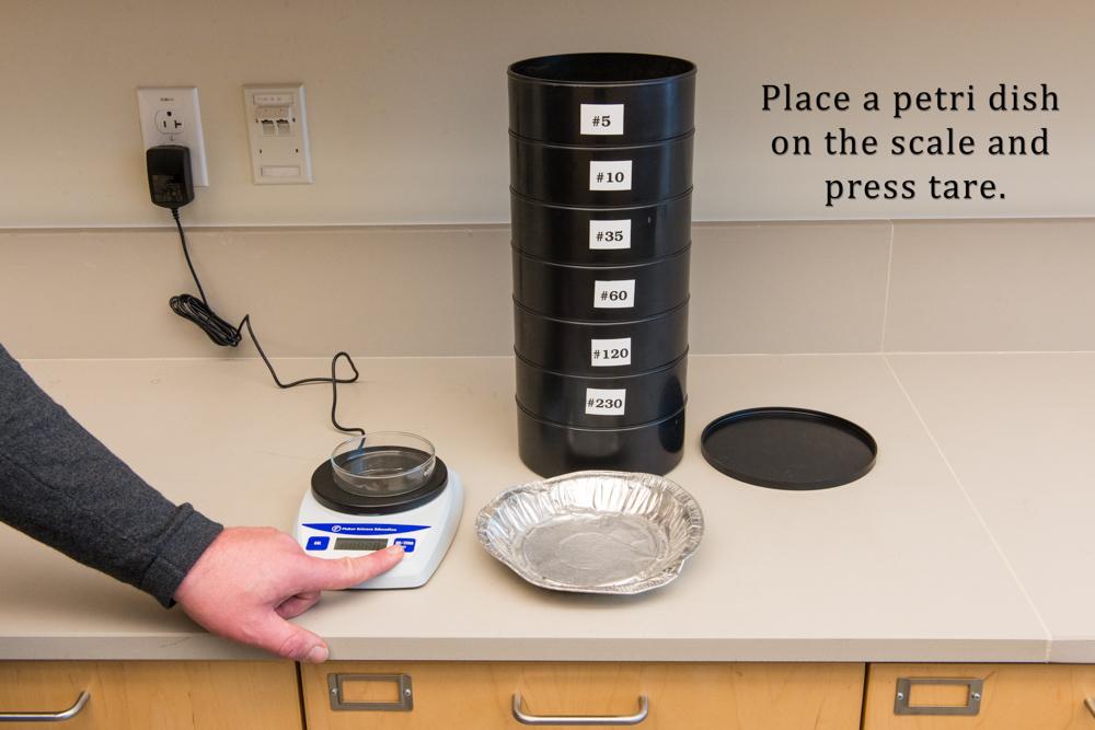
6 6 Step 6 Step 7


7 UNC Coastal Studies Institute 7 Step 8 Step 9

8 8 Step 10 Continue for each sieve and repeat the entire process with the sand sample. Note: Educational sieve sets start at around $50 online at places like Amazon, but teachers do not have to spend that amount of money to use this lesson plan. More affordable options include colanders, window screening, hardware mesh, panty hose, cheesecloth and other similar materials that work equally well with a little creativity. Additionally, teachers do not have to use actual sediment in this process. A composite of snack foods such as peanuts (gravel), sunflower seeds (sand), nerds candy (clay) and others work just as easily. And instead of sieves, the students could simply separate the food items by hand and weigh them separately. As long as the methods are conveyed and the composition of the samples are compared to the control sample is emphasized, this activity can be fun and informative.
9 UNC Coastal Studies Institute 9 Data Worksheet Record the percentages of the control sample provided by your teacher. Control Sample: Sieve #1 Sieve #2 Sieve #3 % - gravel % - fine gravel % - coarse sand Sieve #4 Sieve #5 Sieve #6 % - medium sand % - very fine sand % - silt and clay DIRECTIONS: 1. Record the total weight of the sample before sieving. 2. After sieving, record the weight of the sediment found in each sieve and record below. 3. Take individual weight from each sieve and divide it by the total weight of the sample to get a percentage. Sediment Sample #1 Sieve #1 gravel Sieve #2 fine gravel Sieve #3 coarse sand Sieve #4 medium sand Sieve #5 very fine sand Sieve #6 silt and clay Total weight of sediment sample Sediment Sample #2 Sieve #1 gravel Sieve #2 fine gravel Sieve #3 coarse sand Sieve #4 medium sand Sieve #5 very fine sand Sieve #6 silt and clay Total weight of sediment sample
10 10 DISCUSSION: 1. Which size sediment makes up the highest percentage of sample #1? What percentage is it? 2. Which size sediment makes up the highest percentage of sample #2? What percentage is it? 3. How do the two samples differ? 4. What conclusions can be drawn from these differences? 5. Which sample aligns most closely with the control sample? 6. Would your sample offer an adequate source for beach nourishment? Explain why or why not.
11 UNC Coastal Studies Institute 11 1 EXTENSIONS: This topic offers a lot of opportunity for in-class discussion including the role of taxpayers in providing this resource, how climate change and rising sea levels will impact current methods of beach nourishment, and alternatives to beach nourishment projects. There are a number of excellent resources out there that grapple with this issue and could offer alternative talking points. The Town of Nags Head, North Carolina provides information on its shoreline management projects and can be found at this site: A B89EBAB548} The U.S. Army Corps of Engineers provides an informative publication called the Shore Protection Assessment and it can be accessed here: merasbpa.pdf For a documentary on coastal communities and their relationship coastal processes that shape our shores go here: The Coastal Processes program at the UNC Coastal Studies Institute home page offers a number of resources that covers this topic as well as others affecting our coastal communities. Visit the program page for information about current research projects conducted at the Institute: For a video on how scientists monitor the shorelines in North Carolina click here:
Weathering of Rocks. Weathering - Breakdown of rocks into pieces (sediment) 2 main types of weathering to rocks
 2 main types of weathering to rocks") Weathering of Rocks Weathering - Breakdown of rocks into pieces (sediment) 2 main types of weathering to rocks Mechanical weathering requires physical forces to break rocks into smaller pieces. Chemical
Weathering of Rocks Weathering - Breakdown of rocks into pieces (sediment) 2 main types of weathering to rocks Mechanical weathering requires physical forces to break rocks into smaller pieces. Chemical
The Marine Environment
 The Marine Environment SECTION 16.1 Shoreline Features In your textbook, read about erosional landforms, beaches, estuaries, longshore currents, and rip currents. For each statement below, write true or
The Marine Environment
 The Marine Environment SECTION 16.1 Shoreline Features In your textbook, read about erosional landforms, beaches, estuaries, longshore currents, and rip currents. For each statement below, write or. 1.
Controlling Processes That Change Land
 1 Name Date Controlling Processes That Change Land People try to control some of the processes that change land. To do this, people apply technology- the use of science to solve problems in everyday life.
Coastal Sediment Properties and Longshore Sediment Transport
 Coastal Sediment Properties and Longshore Sediment Transport Julie Rosati Julie.D.Rosati@erdc.usace.army.mil 601-634-3005 Coastal Planning Course Lesson #8 Tuesday 8:00-9:00 am CEM III-1, III-2 1. Coastal
DIVISION OF COASTAL MANAGEMENT TO STUDY CURRENT LONG-TERM EROSION RATES ADJACENT TO TERMINAL GROINS
 DIVISION OF COASTAL MANAGEMENT TO STUDY CURRENT LONG-TERM EROSION RATES ADJACENT TO TERMINAL GROINS North Carolina Department of Environmental Quality Division of Coastal Management February 22, 2018 N.
Geol 117 Lecture 18 Beaches & Coastlines. I. Types of Coastlines A. Definition:
 I. Types of Coastlines A. Definition: 1. Shore = narrow zone where ocean meets land (e.g. beach) 2. Coast is a broad area where both ocean and land processes act a. Includes onshore marshes, dunes, sea
SEGMENTED BREAKWATERS AND THEIR USE IN COASTAL LOUISIANA
 SEGMENTED BREAKWATERS AND THEIR USE IN COASTAL LOUISIANA Prepared by: Louisiana Coastal Protection and Restoration Authority Engineering Division March 2016 The geology of Louisiana s coastal zone is intimately
ENGINEERING WITH NATURE: NEARSHORE BERM PLACEMENTS AT FORT MYERS BEACH AND PERDIDO KEY, FLORIDA, USA
 1 ENGINEERING WITH NATURE: NEARSHORE BERM PLACEMENTS AT FORT MYERS BEACH AND PERDIDO KEY, FLORIDA, USA KATHERINE E. BRUTSCHÉ 1, PING WANG 2, JULIE D. ROSATI 1, CHERYL E. POLLOCK 1 1. U.S. Army Engineer
The Coast: Beaches and Shoreline Processes
 1 2 3 4 5 6 7 8 9 The Coast: es and Shoreline Processes Trujillo & Thurman, Chapter 10 Oceanography 101 Chapter Objectives Recognize the various landforms characteristic of beaches and coastal regions.
The Coast: Beaches and Shoreline Processes Trujillo & Thurman, Chapter 10
 The Coast: es and Shoreline Processes Trujillo & Thurman, Chapter 10 Oceanography 101 Chapter Objectives Recognize the various landforms characteristic of beaches and coastal regions. Identify seasonal
Chapter 17. Ocean and Coastal Processes
 Chapter 17 Ocean and Coastal Processes Ocean Basins and Plates Ocean Basins Ocean Basins are profoundly different from the continents. Ocean crust is thin and dense and young. New ocean crust is generated
DESIGN ENGINEERING ANALYSIS FOR TERMINAL GROIN LENGTH
 APPENDIX F DESIGN ENGINEERING ANALYSIS FOR TERMINAL GROIN LENGTH (Prepared by Olsen Associates, Inc.) DRAFT Environmental Impact Statement Village of Bald Head Island Shoreline Protection Project Brunswick
Bob Van Dolah. Marine Resources Research Institute South Carolina Department of Natural Resources
 Bob Van Dolah Marine Resources Research Institute South Carolina Department of Natural Resources Shoreline Change Will Occur! On our front beaches where it is not easy to retreat Shoreline Change Will
Professors Dean and Dalrymple are also authors of the well-known Water Wave Mechanics for Engineers and Scientists.
 COASTAL PROCESSES The world s coastlines, dividing land from sea, are geological environments unique in their composition and the physical processes affecting them. Humans have been building structures
Objectives. Vocabulary
 Shoreline Features Objectives Explain how shoreline features are formed and modified by marine processes. Describe the major erosional and depositional shoreline features. Vocabulary wave refraction beach
Coastal Processes 101. Greg Berman (Woods Hole Sea Grant & Cape Cod Cooperative Extension)
") Coastal Processes 101 Greg Berman (Woods Hole Sea Grant & Cape Cod Cooperative Extension) January 23, 2019 Coastal Processes 101 Outline: ~30 min talk Coastal Processes What is Erosion? Value of the Ecosystem
Coastal Processes 101 Greg Berman (Woods Hole Sea Grant & Cape Cod Cooperative Extension) January 23, 2019 Coastal Processes 101 Outline: ~30 min talk Coastal Processes What is Erosion? Value of the Ecosystem
Regional-scale understanding of the geologic character and sand resources of the Atlantic inner continental shelf, Maine to Virginia
 Regional-scale understanding of the geologic character and sand resources of the Atlantic inner continental shelf, Maine to Virginia Workshop on Dredging, Beach Nourishment and Bird Conservation Atlantic
The U.S. Army Corps of Engineers Philadelphia District
 The U.S. Army Corps of Engineers Philadelphia District The Atlantic Coast of New Jersey Regional Sediment Budget 1986-2003 Cape May Point to Manasquan Inlet Final Report March 2006 The Atlantic Coast of
Changes in Texas Ecoregions Copy the questions and answers
 Changes in Texas Ecoregions Copy the questions and answers 1. What are some kinds of damage that hurricanes cause? Roads and bridges might be washed away. Trees and power lines can be knocked down. Area
Erosion and Deposition along Rivers and Seashores - Part 1: Modeling in the Classroom
 Erosion and Deposition along Rivers and Seashores - Part 1: Modeling in the Classroom Lesson Focus: Erosion and Deposition Learning Objectives: Students will learn to recognize landforms found on Earth.
Dynamic preservation of the coastline
 Dynamic preservation of the coastline Content Introduction The Dutch coastal defence by dynamic processes Data collection Management of the sand resources Growing importance of marine sand and gravel resources
Supplemental Slides. Shore: Junction of Land & Water. Junction of Land & Water. Sea Level Variations. Shore vs. Coast. Sea Level Variations
 Shore: Junction of Land & Water Supplemental Slides Sediments come off land Most get dumped at the beach Sediment interacts with ocean waves and currents Junction of Land & Water Features: Breaking waves,
Shore: Junction of Land & Water. Sediments come off land Most get dumped at the beach Sediment interacts with ocean waves and currents
 Shore: Junction of Land & Water Supplemental Slides Sediments come off land Most get dumped at the beach Sediment interacts with ocean waves and currents Junction of Land & Water Features: Breaking waves,
Page 1. Name:
 Name: 1) Which event is the best example of erosion? dissolving of rock particles on a limestone gravestone by acid rain breaking apart of shale as a result of water freezing in a crack rolling of a pebble
Marine Ecology Pacing Guide
 Marine Ecology Pacing Guide Course Description: The focus of the course is the interrelationships among marine organisms and the physical, chemical, geological and biological factors. North Carolina coastal
Lab 12 Coastal Geology
 Lab 12 Coastal Geology I. Fluvial Systems Hydrologic Cycle Runoff that flows into rivers = precipitation (rain and snowmelt) [infiltration (loss to groundwater) + evaporation (loss to atmosphere) + transpiration
FILL SUITABILITY CHARACTERIZATION OF A COMPLEX COASTAL AREA: DARE COUNTY, NORTH CAROLINA
 FILL SUITABILITY CHARACTERIZATION OF A COMPLEX COASTAL AREA: DARE COUNTY, NORTH CAROLINA Donald K. Stauble 1, William Birkemeier, Michael F. Forte and William A. Dennis 3 ABSTRACT As part of the design
Erosion and Deposition
 CHAPTER 3 LESSON 2 Erosion and Deposition Landforms Shaped by Water and Wind Key Concepts What are the stages of stream development? How do water erosion and deposition change Earth s surface? How do wind
Alexandra Carvalho, Ph.D., GISP Kathy Fitzpatrick, P.E.
 Coastal Data Organization for Project Management and Coastal Planning Martin County, Florida Alexandra Carvalho, Ph.D., GISP Kathy Fitzpatrick, P.E. Outline County Coastal Programs Coastal Geodatabase
Geology Setting Management Options Management Structure
 Geology Setting Management Options Management Structure WFF = Wallops Flight Facility LST = Longshore sediment transport SLR = Sea level rise September 29, 2015 Accomack County/Accomack Northampton County
Ocean and Coastal Processes. Ocean Basins. Chapter 20. Ocean Basins and Plates. Ocean Terms. Sea Arch Bay-mouth Bar Spit Tombolo Coast.
 Chapter 20 Ocean Basins and Plates Ocean and Coastal Processes Tide Wave Height Length Period Base Refraction Tsunami Beach Sea stack Ocean Terms Sea Arch Bay-mouth Bar Spit Tombolo Coast Emergent Submergent
UNIT 1: WATER SYSTEMS ON EARTH CHAPTER 2: OCEANS CONTROL THE WATER CYCLE
 UNIT 1: WATER SYSTEMS ON EARTH CHAPTER 2: OCEANS CONTROL THE WATER CYCLE ORIGINS OF OCEAN WATER OCEANS HAVE FILLED OVER HUNDREDS OF MILLIONS OF YEARS SCIENTISTS BELIEVE THE OCEANS ARE MORE THAN 3 BILLION
Coastal Systems and Landscapes 3 days
 AS Level Geography WJEC Coastal Systems and Landscapes 3 days This course is for Welsh schools. This in-depth course prepares students for the physical fieldwork focusing on the Coastal option, for Section
The Erosion Problem: Perspectives. Physical
 Greg Berman The Erosion Problem: Perspectives Physical Education Regulation The Erosion Problem: Physical Perspectives What is a hotspot? Erosion Rate / Vulnerability / Frame of Reference Sandwich Town
Connecticut Coastal Management Program
 Connecticut Coastal Management Program Fact Sheet for SHORELINE FLOOD AND EROSION CONTROL STRUCTURES What are Shoreline Flood and Erosion Control Structures? The Connecticut General Statutes (CGS) define
Coastal Sediment Transport
 Coastal & Marine Coastal Sediment Transport Mazen Abualtayef Assistant Prof., IUG, Palestine Sediment Transport Sediment is any particulate matter that can be transported by fluid flow and which eventually
GCSE 4242/02 GEOGRAPHY (Specification B) FOUNDATION TIER UNIT 2 SECTION B
 FOUNDATION TIER UNIT 2 SECTION B") Surname Centre Number Candidate Number Other Names 0 GCSE 4242/02 GEOGRAPHY (Specification B) FOUNDATION TIER UNIT 2 SECTION B S15-4242-02 P.M. WEDNESDAY, 3 June 2015 1 hour 30 minutes For s use Part Maximum
Surname Centre Number Candidate Number Other Names 0 GCSE 4242/02 GEOGRAPHY (Specification B) FOUNDATION TIER UNIT 2 SECTION B S15-4242-02 P.M. WEDNESDAY, 3 June 2015 1 hour 30 minutes For s use Part Maximum
Earth Science Lesson Plan Quarter 2, Week 10, Day 1
 Earth Science Lesson Plan Quarter 2, Week 10, Day 1 Outcomes for Today Standard Focus: PREPARE 1. Background knowledge necessary for today s reading. Beaches are created by the actions of waves, tides,
Coastal issues: Beaches and Estuaries
 Coastal issues: Beaches and Estuaries Definitions: Coast = broad zone where both marine & terrestrial processes act It includes the beach, lagoons, marshes, bars etc. Coastal processes act to shape the
Mapping Coastal Change Using LiDAR and Multispectral Imagery
 Mapping Coastal Change Using LiDAR and Multispectral Imagery Contributor: Patrick Collins, Technical Solutions Engineer Presented by TABLE OF CONTENTS Introduction... 1 Coastal Change... 1 Mapping Coastal
Lab Activity on Sedimentary Processes
 Lab Activity on Sedimentary Processes 2002 Ann Bykerk-Kauffman, Dept. of Geological and Environmental Sciences, California State University, Chico * Objectives When you have completed this lab activity,
ADVENTURES IN WATER DEVELOPED BY LOUISVILLE WATER COMPANY
 ADVENTURES IN WATER DEVELOPED BY LOUISVILLE WATER COMPANY Tunneling for Water explains the science behind a first-of-its-kind project in the world! Louisville Water Company is the first water utility
Kelly Sears, 8 th Grade Science Teacher Smith Middle School, Chapel Hill, NC Submitted to COSEE SE Dec, 2006
 Kelly Sears, 8 th Grade Science Teacher Smith Middle School, Chapel Hill, NC Submitted to COSEE SE Dec, 2006 (The following unit plan for Eighth Grade presents activities and worksheets based upon Kelly
In 1990, 50% of the U.S. population lived within 75 km of a coast. By 2010, 75% of the U.S. population will live within 75 km of a coast.
 In 1990, 50% of the U.S. population lived within 75 km of a coast. By 2010, 75% of the U.S. population will live within 75 km of a coast. High Tech Methods for Surveying the Deep Sea Floor Fig. 20.18 1
Geology Chapter Teacher Sheet. Activity #3: Determining the Percolation Rate of Soil
 Geology Chapter Teacher Sheet Activity #3: Determining the Percolation Rate of Soil Adapted from The Percolation Rate of a Soil, CurriculumResources for Earth Science Teachers, Maine Department of Conservation.
2nd Grade. Wind, Water and Land.
 1 2nd Grade Wind, Water and Land 2015 11 23 www.njctl.org 2 Wind, Water and Land What is Wind? Wind Erosion Preventing Wind Erosion Water Erosion Sudden Water Erosion Preventing Water Erosion Landforms
Materials. Use materials meeting the following.
 208.01 Section 208. SOIL EROSION AND SEDIMENTATION CONTROL 208.01 Description. Install and maintain erosion and sedimentation controls to minimize soil erosion and to control sedimentation from affecting
COASTAL DYNAMICS VIRTUAL FIELD TRIP, NORTHEAST FLORIDA. Joann Mossa Department of Geography University of Florida
 COASTAL DYNAMICS VIRTUAL FIELD TRIP, NORTHEAST FLORIDA Joann Mossa Department of Geography University of Florida WHERE ARE WE GOING? In NE Florida (Flagler and St. Johns County, south of St. Augustine),
SHORELINE AND BEACH PROCESSES: PART 2. Implications for Coastal Engineering
 SHORELINE AND BEACH PROCESSES: PART 2 Implications for Coastal Engineering Objectives of the lecture: Part 2 Show examples of coastal engineering Discuss the practical difficulties of ocean engineering
EDUCATION PROGRAMS GUIDE
 EDUCATION PROGRAMS GUIDE Inner Space Center University of Rhode Island Graduate School of Oceanography innerspacecenter.org ABOUT THE ISC The Inner Space Center (ISC) is an international leader in ocean
The Norwood Science Center. Geology (Minerals) Grade 4
 Grade 4") The Norwood Science Center Geology (Minerals) Grade 4 Background Information: Where do rocks come from? At first you might think the answer to this question is simple. Igneous rock comes from either magma
The Norwood Science Center Geology (Minerals) Grade 4 Background Information: Where do rocks come from? At first you might think the answer to this question is simple. Igneous rock comes from either magma
Draft exercise for share fair at Bozeman workshop only. This exercise is not ready for distribution. Please send helpful suggestions to
 Draft exercise for share fair at Bozeman workshop only. This exercise is not ready for distribution. Please send helpful suggestions to foleyd@plu.edu Figure list 1. Trailer photograph 2. Location map
MEMORANDUM FOR SWG
 MEMORANDUM FOR SWG-2007-1623 Subject: Jurisdictional Determination (JD) for SWG-2007-1623 on Interdunal Wetlands Adjacent to Traditional Navigable Waters (TNWs) Summary The U.S. Environmental Protection
Essential Questions. What is erosion? What is mass wasting?
 Erosion Essential Questions What is erosion? What is mass wasting? What is Erosion? Erosion The transportation of sediment from one area to another Caused mainly by running water but also caused by glaciers,
Unit 1: Water Systems on Earth Chapter 2
 Unit 1: Water Systems on Earth Chapter 2 Create a mind map with the driving question, Why are Oceans Important? Remember: Why are oceans so important? Why are oceans so important? Primary water source
Bay Area Scientists in Schools Presentation Plan
 Bay Area Scientists in Schools Presentation Plan Lesson Name Presenter(s) The Water Cycle UC Berkeley PhD students Grade Level 1 Standards Connection(s) Earth Sciences, physics sciences CA Science Content
Primer on Coastal Erosion And Habitat Creation
 2 nd Regional Conference Dredging, Beach Nourishment & Bird Conservation Primer on Coastal Erosion And Habitat Creation Timothy Kana Ph.D Source: Newsday 1962 Photo by Kelsey Aerials 1978 Source: U Mass
What is weathering and how does it change Earth s surface? Answer the question using
 7 th Grade Lesson What is weathering and how does it change Earth s surface? Answer the question using the sentence frame. You have 4 minutes. Weathering is. This changes the Earth s surface because. 1
Developed in Consultation with Florida Educators
 Developed in Consultation with Florida Educators Table of Contents Next Generation Sunshine State Standards Correlation Chart... 7 Benchmarks Chapter 1 The Practice of Science...................... 11
What Is Water Erosion? Aren t they the same thing? What Is Sediment? What Is Sedimentation? How can Sediment Yields be Minimized?
 Jerald S. Fifield, Ph.D. CISEC HydroDynamics Incorporated Parker, CO 303-841-0377 Aren t they the same thing? What Is Sediment? Soil particles deposited or suspended in water or air The process of depositing
RESULTS FROM THE TEXAS COASTAL SEDIMENT SOURCES: A GENERAL EVALUATION STUDY
 RESULTS FROM THE TEXAS COASTAL SEDIMENT SOURCES: A GENERAL EVALUATION STUDY JUAN MOYA KELSEY CALVEZ CRIS WEBER ANTHONY RISKO *KEVIN FRENZEL FREESE AND NICHOLS, INC. COASTAL AND WATERWAYS GROUP OBJECTIVES
3.0 ROBERTS BANK TIDAL FLAT MORPHOLOGY
 Vancouver Port Authority Northwest Hydraulic Consultants Ltd. /Triton Consultants Ltd. Roberts Bank Container Expansion File: 33863 Coastal Geomorphology Study - 19 - November 2004 3.0 ROBERTS BANK TIDAL
1 Earth s Oceans. TAKE A LOOK 2. Identify What are the five main oceans?
 CHAPTER 13 1 Earth s Oceans SECTION Exploring the Oceans BEFORE YOU READ After you read this section, you should be able to answer these questions: What affects the salinity of ocean water? What affects
Changes in Ecosystems - Natural Events
 Changes in Ecosystems - Natural Events 8A predict and describe how different types of catastrophic events impact ecosystems such as floods, hurricanes, or tornadoes Textbook pages: 396-406 How can ecosystems
SHORELINE MANAGEMENT PLAN FOR OWEN ANCHORAGE AND COCKBURN SOUND SHORELINE MONITORING PLAN
 SHORELINE MANAGEMENT PLAN FOR OWEN ANCHORAGE AND COCKBURN SOUND SHORELINE MONITORING PLAN CHAPTER EIGHT OF DOCUMENT: LONG-TERM SHELLSAND DREDGING, OWEN ANCHORAGE ENVIRONMENTAL MANAGEMENT PROGRAMME JUNE
Directed Reading. Section: The Water Planet. surface is called the a. Earth s ocean. b. Pacific Ocean. c. salt-water ocean. d. global ocean.
 Skills Worksheet Directed Reading Section: The Water Planet 1. The body of salt water covering nearly three-quarters of the Earth s surface is called the a. Earth s ocean. b. Pacific Ocean. c. salt-water
Day 3 Weathering and Erosion.notebook. October 02, Section 7.2. Erosion and Deposition. Objectives
 Objectives Describe the relationship of gravity to all agents of erosion. Contrast the features left from different types of erosion. Analyze the impact of living and nonliving things on the processes
Notes and Summary pages:
 Topographic Mapping 8.9C Interpret topographical maps and satellite views to identify land and erosional features and predict how these shapes may be reshaped by weathering ATL Skills: Communication taking
Marine Biodiversity: Global Ocean to the Salish Sea Design Your Own Salish Sea Creature
 Science Unit: Lesson #2 Marine Biodiversity: Global Ocean to the Salish Sea Design Your Own Salish Sea Creature Summary: Lesson type: Grade level: Duration of lesson: Developed by: Developed for: Based
Mapping rainfall and flooding
 Mapping rainfall and flooding BY DAVID WALBERT Although Hurricane Floyd was the biggest storm of 1999 and the one most remembered, eastern North Carolina was hit by three hurricanes in a six-week period
ENGINEERING APPROACHES TO SHORELINE PLACEMENT FROM COAST TO COAST
 ENGINEERING APPROACHES TO SHORELINE PLACEMENT FROM COAST TO COAST 237 237 237 217 217 217 200 200 200 0 0 0 163 163 163 131 132 122 80 119 27 252 174.59 83 36 118 110 135 120 112 92 56 62 102 130 Comparing
Weathering, Erosion, and Deposition
 Weathering, Erosion, and Deposition E Q : H O W I S T H E E A R T H A F F E C T E D B Y C O N S T R U C T I V E A N D D E S T R U C T I V E F O R C E S? http://player.discoveryeducation.com/index.cfm?guidassetid=6b1e329e-5a77-4b36-bfa9-1d307f75441c&blnfromsearch=1&productcode=us
Erosion and Deposition
 Erosion and Deposition The Erosion-Deposition Process What do you think? Read the two statements below and decide whether you agree or disagree with them. Place an A in the Before column if you agree with
Dunes Growth Estimation for Coastal Protection
 Dunes Growth Estimation for Coastal Protection Muhammad Zikra Department of Ocean Engineering, Faculty of Marine Technology, ITS, Kampus ITS Keputih Sukolilo, Surabaya 60111 Abstract: This paper describes
Sediment Management in the Coastal Bays
 Sediment Management in the Coastal Bays Introduction Need for ecosystem view of sediment management in Coastal Bays Island loss and restoration Navigation needs Habitat Trade offs Living Shoreline Requirements
Science EOG Review: Landforms
 Mathematician Science EOG Review: Landforms Vocabulary Definition Term canyon deep, large, V- shaped valley formed by a river over millions of years of erosion; sometimes called gorges (example: Linville
AGY 514 Marine Geology COURSE PARTICULARS COURSE INSTRUCTORS COURSE DESCRIPTION COURSE OBJECTIVES
 AGY 514 Marine Geology COURSE PARTICULARS Course Code: AGY 514 Course Title: Marine Geology No. of Units: 3 Course Duration: Two hours of theory and three hours of practical per week for 15 weeks. Status:
Linking Inlet Hydrodynamics and Morphologic Response at Oregon Inlet, NC
 Linking Inlet Hydrodynamics and Morphologic Response at Oregon Inlet, NC Prepared for: Sharon Ahlers Engineering Communications Program Cornell University Prepared by: Justin Vandever School of Civil and
Tracking the Salt Front
 Tracking the Salt Front Students will use Hudson River salinity data to practice math skills as they track movements of the salt front in response to storms and other weather events. Objectives: Students
Which map shows the stream drainage pattern that most likely formed on the surface of this volcano? A) B)
 B)") 1. When snow cover on the land melts, the water will most likely become surface runoff if the land surface is A) frozen B) porous C) grass covered D) unconsolidated gravel Base your answers to questions
1. When snow cover on the land melts, the water will most likely become surface runoff if the land surface is A) frozen B) porous C) grass covered D) unconsolidated gravel Base your answers to questions
1 Shoreline Erosion and Deposition
 CHAPTER 12 1 Shoreline Erosion and Deposition SECTION Agents of Erosion and Deposition BEFORE YOU READ After you read this section, you should be able to answer these questions: What is a shoreline? How
Coastal Barrier Island Network (CBIN): Management strategies for the future
: Management strategies for the future") Coastal Barrier Island Network (CBIN): Management strategies for the future Heather Joesting*, Amy Williams**, Rusty Feagin**, and William K. Smith* *Department of Biology, Wake Forest University, Winston
Coastal Barrier Island Network (CBIN): Management strategies for the future Heather Joesting*, Amy Williams**, Rusty Feagin**, and William K. Smith* *Department of Biology, Wake Forest University, Winston
Earth Science Chapter 9. Day 6 - Finish Capillary Action Lab - Quiz over Notes - Review Worksheets over Sections 9.2 and 9.3
 Earth Science Chapter 9 Day 1 Day 2 Day 3 Read Section 9.1 Surface Water Chapter 9 Term Sheet Notes over Section 9.1 Surface Water Section 9.1 Review Worksheets Quiz over Section 9.1 Notes Virtual Lab
A SEDIMENT BUDGET ANALYSIS AND MANAGEMENT STRATEGY FOR FORT PIERCE INLET, FL
 A SEDIMENT BUDGET ANALYSIS AND MANAGEMENT STRATEGY FOR FORT PIERCE INLET, FL By Elba Rodriguez and Robert G. Dean Department of Civil and Coastal Engineering University of Florida Gainesville, FL 32611,
Lesson 4. Stream Table Lab. Summary. Suggested Timeline. Objective. Materials. Teacher Background Knowledge
 Rivers Instructional Case: A series of student-centered science lessons Suggested Timeline 50 minutes Materials 1 Stream table for each station 1 Calculator for each station Approximately 3 lb of sand
Hurricane Matthew Threats and Impacts Briefing for Eastern NC
 Hurricane Matthew Threats and Impacts Briefing for Eastern NC October 6 th, 2016 Date/Time Created: 10/6/2016, Noon EDT National Weather Service Newport/Morehead City, NC Hurricane Matthew Key Points Changes
1. Erosion by Running Water Most powerful cause of erosion
 I. Destructive Forces Notes: Destructive force: a process in which land is destroyed or changed such as weathering and erosion. All landforms are a result of a combination of constructive and destructive
SAND ANALYSIS EXERCISE
 SAND ANALYSIS EXERCISE Step 1: Taking Beach Sediment Samples Equipment: Sample cups; three(3) per profile Permanent ink marker A. Take one sand sample from the foredune, berm top, and beachface areas.
The Use of Geographic Information Systems to Assess Change in Salt Marsh Ecosystems Under Rising Sea Level Scenarios.
 The Use of Geographic Information Systems to Assess Change in Salt Marsh Ecosystems Under Rising Sea Level Scenarios Robert Hancock The ecological challenges presented by global climate change are vast,
Mangrove Erosion in the Mekong delta
 Mangrove Erosion in the Mekong delta 1. Introduction a. Mangrove coast - a balance between different forcing factors Mangroves are coastal environments frequently observed in the tropical muddy coasts.
Cliff stabilisation. Adaptation Option Climate-ADAPT
 Cliff stabilisation Adaptation Option Climate-ADAPT Cover design: EEA Cover photo: EEA Layout: EEA Legal notice The contents of this publication do not necessarily reflect the official opinions of the
Map 4: Cowal Peninsula: Cluniter to Ardyne Point Map Content Descriptions
 Map 4: Cowal Peninsula: Cluniter to Ardyne Point Map Content Descriptions 1. Built Heritage and Archaeology A total of twenty four sites were recorded in the area covered by Map 4. Of these six were previously
Lab 7: Sedimentary Structures
 Name: Lab 7: Sedimentary Structures Sedimentary rocks account for a negligibly small fraction of Earth s mass, yet they are commonly encountered because the processes that form them are ubiquitous in the
Erosion Skittles Experiment
 Erosion Skittles Experiment Free PDF ebook Download: Erosion Skittles Experiment Download or Read Online ebook erosion skittles experiment in PDF Format From The Best User Guide Database 34. Erosion Experiments.
Topic 6: Weathering, Erosion and Erosional-Deposition Systems (workbook p ) Workbook Chapter 4, 5 WEATHERING
 Workbook Chapter 4, 5 WEATHERING") Topic 6: Weathering, Erosion and Erosional-Deposition Systems (workbook p. 95-125) Workbook Chapter 4, 5 THE BIG PICTURE: Weathering, erosion and deposition are processes that cause changes to rock material
Topic 6: Weathering, Erosion and Erosional-Deposition Systems (workbook p. 95-125) Workbook Chapter 4, 5 THE BIG PICTURE: Weathering, erosion and deposition are processes that cause changes to rock material
Depositional Environment
 Depositional Environment Sedimentary depositional environment describes the combination of physical, chemical and biological processes associated with the deposition of a particular type of sediment. Types
Term Knowledge Using and applying Grade Criteria Autumn 1 Assessment window October Natural hazards pose major risks to people and property.
 Assessment Schedule Year 9 2015/6 Term Knowledge Using and applying Grade Criteria Autumn 1 Assessment window October 2015 3.1.1.2 Tectonic Natural hazards pose major risks to people and property. Definition
Summary. Streams and Drainage Systems
 Streams and Drainage Systems Summary Streams are part of the hydrologic cycle and the chief means by which water returns from the land to the sea. They help shape the Earth s surface and transport sediment
STUDENT NAME DATE ID GRADE 5 SCIENCE
 STUDENT NAME DATE ID GRADE 5 SCIENCE Administered October 2007 DIRECTIONS Read each question and choose the best answer. Be sure to mark your answers. SAMPLE A Objects That Conduct Heat Silver spoon Copper