Dynamic preservation of the coastline
|
|
|
- Lewis McKenzie
- 5 years ago
- Views:
Transcription

1 Dynamic preservation of the coastline
2 Content Introduction The Dutch coastal defence by dynamic processes Data collection Management of the sand resources


3 Growing importance of marine sand and gravel resources Annually between 47 and 59 billion tonnes of solid material is extracted worldwide. Sand and gravel forms with 68% to 85% the greatest part of it. Marine extraction is increasing due to the exhausting of the resources on land. In the European seas yearly c. 94. million m 3 is extracted.


4 Applications of marine sand and gravel Coastal extensions and artificial islands Landfill Beach nourishment Burial of pipelines Industrial use for concrete and mortar sand

 live below sea level, locally")


5 The Dutch lowlands Some figures about The Netherlands: NL 55% of the country is laying below sea level 60 % (10.2 million people) live below sea level, locally as low as -7 m. 65% of the national gross product is from this area Below mean sea level 55%: of its territory 60%: of its population 65%: of its national gross product Hansje Brinkers The earliest early warning system


6 Keeping the country dry for more than 1000 years Subsidence


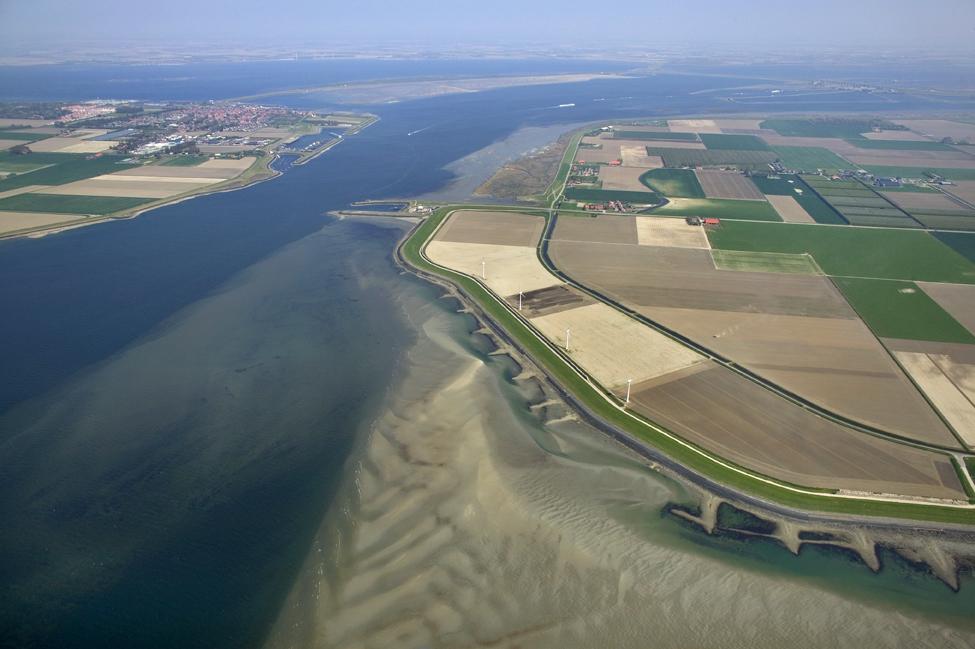
7 Yearly measuring of the coastline Basal Coast Line, since 1990 No further retreat of the entire 400 km coastline excepted High tide Check points Low tide Yearly survey to detect coastal retreat


8 Coastal defence methods Coastal nourishment program: At the beach In the foreshore At the beach and foreshore Aim: Dynamic preservation of the coastline Maintaining the overall sediment availability in the coastal system


9 Sand engine In million m 3 of marine sand was dredged and dumped at the foreshore Expected to be transported along the coast in northwards direction in 20 years The behaviour of the sand body is monitoring by jetski s and video camera s


10 Protection of a coastal protection dam The nourishment is still in progress, ready in 2015 To protect a 5 km long dam in 2014 a project started to supply 36 million m 3 sand in the foreshore. Against the dama dune ridge will be formed Existing situation new situation

11 Beach nourishment amounts along the Dutch coast Yellow beach nourishment, blue foreshore nourishment, red line percentage of erosion of the basal coastline


12 New land by interupting longshore transport by extension of a harbor dam Sedimentation over 5 km, about 7 million m 3 and has been collected behind the dam. Reach of equilibrium expected in 2025 Former coastline
13 Methods for detecting extractable sand resources


14 Acoustic methods Multibeam Side scan sonar for obstacles, like wrecks Multibeam for morphology Vertical acoustic profiling with for detecting thicknesses of the sand resources and clay layers


15 Sea bed sampling Boxcorer Undisturbed sample 0-50 cm Vibrocorer Undisturbed Sample 0-6 m Disturbed sample Van Veen grab 0-20 cm
16 Management of marine sand resources

17 2D mapping of sand extraction areas Presentation of the D50 of the sand fraction and the silt fraction <63 micron of the upper 2 metres of the sea bed in a sand extraction area Extraction permitted at -20 m isobath or at 20 km from the coastline

18 Search for pollutants Each sand extraction area has to be investigated for the presence of contaminants. The following elements have to analysed: Dry and organic matter Fraction <2 micron Cadmium Chrome Copper Mercury Lead Nickel Zinc Mineral oil Polycyclic Aromatic Hydrocarbons PCB s Organochloric pesticides Tributylene Of each 6 cores in an area a mixed sample of each 0.50 cm depth has to be analysed
19 Management of marine sand resources To assure that on the long term the sand budget will sufficient to maintain the coastline, a tool has to be developed to provided the authorities with adequate information. Management of offshore sand resources requires both knowledge on the quantity and quality of sand and a tool to visualize this information. Traditional 2D mapping -> good result, but time consuming i.e. costly New method: A 3D model which can be used in a decision support system


20 Available data Zone of interest Informations of boreholes Particle size analyses High resolution acoustic information Extraction permitted beyond the 20 m isobath or at 20 km from the coastline

21 Soil sample locations Pattern of soil sample locations in the zone of interest

22 Data Layer model Pattern of interpreted high resolution acoustic information in the zone of interest
23 Method 3D kriging using spatial correlation structures Interpolation of soil classes, silt % and shell % Voxels m 1. Fine sand ( µm) 2. Medium sand ( µm) 3. Coarse sand ( µm) 4. Very coarse sand( ) 5. Sand unknown 6. Clay/loam 7. Peat 8. Shells Soil classification 1. Silt 0-2% 2. Silt 2-4% 3. Silt 4-10% 4. Silt >10% 1. no shells 2. shells 0-1% 3. shells 1-10% 4. shells 10-30% 5. shells unknown Silt fraction classification Shell percentage

24 Data layer model based on available information Total depth below sea bed 12 m Fine sand Medium fine Medium coarse Coarse Sand grain size unknown Clay Peat Shells
25 Extractability criteria Fine-grained layers: critical thickness and type of sediment sand extractable fine grained or clay sand non extractable
26 Different scenarios Extractability criteria Geology? Scenario Cri*cal thickness Lithology of fine- grained layers A no - B1 1,0 metre On clay/peat layers B2 0.5 metre On clay/peat layers C 1,0 metre On silt classes 3 & 4, clay/loam/peat)
27 Sand thicknesses with different scenarios Thickness to 12 m below sea bed without critical thickness of unextractable clay, silt or peat layers Thickness of the extractable sand resources with critical thickness of 0,5 m upon an unextractable layer

28 Sand volumes with different scenarios

29 Extractable sand with pipelines and cables routes No dredging within 500 m at each side of the cable or pipeline Short term, no extraction in the pipeline routes and electric cable routes from windmill parks Long term, lifetime pipelines and electric cables c. 30 years. After removal sand resources become available.
30 Conclusions Small scaled foreshore sand nourishment appeared to be more effective on the short term than large scale foreshore nourishment because of the long term process involved. A flexible decision-support system with a powerful and easy-to-understand visualization component is more useful than traditional mapping results. The flexibility of the system, with possibilities for refinement and for the addition of non-geological expertise, is its main strength.
31 Thank you for your attention!
Geophysical Site Surveys
 Geophysical Site Surveys Simon Oakley Geoscience Team Leader Fugro Survey Limited 16/04/2014 Contents Menu Introduction Section 1 - Geophysical Site Surveys - Seabed Bathymetry - Shallow Geology - Seabed
Geol 117 Lecture 18 Beaches & Coastlines. I. Types of Coastlines A. Definition:
 I. Types of Coastlines A. Definition: 1. Shore = narrow zone where ocean meets land (e.g. beach) 2. Coast is a broad area where both ocean and land processes act a. Includes onshore marshes, dunes, sea
Environmental impact assessment study of the new offshore dumping sites for Šventoji port in Lithuania
 Environmental impact assessment study of the new offshore dumping sites for Šventoji port in Lithuania Introduction Summary In 2003 Lithuanian Ministry of Transport initiated the preparation of feasibility
b Blackwell Science Environmental Geology PRINCIPLES AND PRACTICE
 Environmental Geology PRINCIPLES AND PRACTICE Fred G. Bell Department of Geology and Applied Geology University of Natal, Durban, South Africa b Blackwell Science Preface, ix 1 Introduction, 1 1.1 Planning
KEYWORDS: erosion shoreline change nourishment community issues
 UNC Coastal Studies Institute 1 TITLE: Sand, Soil, Sediment Selection for Beach Nourishment KEYWORDS: erosion shoreline change nourishment community issues ABSTRACT: North Carolina s barrier islands are
The Marine Environment
 The Marine Environment SECTION 16.1 Shoreline Features In your textbook, read about erosional landforms, beaches, estuaries, longshore currents, and rip currents. For each statement below, write true or
26 Coastal erosion and accretion
 26 Coastal erosion and accretion 26.1 Rate of erosion and accretion 26.2 Length of protected coastline 26.3 Volume of sand nourishment Fig. 26.1: Coastline dynamics of the South East Baltic region Key
BUDGET. Investigation of natural sand transport on the Belgian continental shelf
 BUDGET Investigation of natural sand transport on the Belgian continental shelf Funded by Federal Office for Scientific, Technical and Cultural Affairs Program: Sustainable Management of the North Sea
Introduction to Acoustic Remote Sensing and Seafloor Mapping (AE4-E13) May 19, 2010
 May 19, 2010") Introduction to Acoustic Remote Sensing and Seafloor Mapping (AE4-E13) May 19, 2010 1 Delft Vermelding Institute onderdeel of Earth organisatie Observation and Space Systems Why Acoustic Remote Sensing?
Introduction to Acoustic Remote Sensing and Seafloor Mapping (AE4-E13) May 19, 2010 1 Delft Vermelding Institute onderdeel of Earth organisatie Observation and Space Systems Why Acoustic Remote Sensing?
The Coast: Beaches and Shoreline Processes
 1 2 3 4 5 6 7 8 9 The Coast: es and Shoreline Processes Trujillo & Thurman, Chapter 10 Oceanography 101 Chapter Objectives Recognize the various landforms characteristic of beaches and coastal regions.
The Coast: Beaches and Shoreline Processes Trujillo & Thurman, Chapter 10
 The Coast: es and Shoreline Processes Trujillo & Thurman, Chapter 10 Oceanography 101 Chapter Objectives Recognize the various landforms characteristic of beaches and coastal regions. Identify seasonal
SHORELINE AND BEACH PROCESSES: PART 2. Implications for Coastal Engineering
 SHORELINE AND BEACH PROCESSES: PART 2 Implications for Coastal Engineering Objectives of the lecture: Part 2 Show examples of coastal engineering Discuss the practical difficulties of ocean engineering
2. REGIS II: PARAMETERIZATION OF A LAYER-BASED HYDROGEOLOGICAL MODEL
 HYDRAULIC PARAMETERIZATION OF 3D SUBSURFACE MODELS: FROM MEASUREMENT-SCALE TO MODEL-SCALE Jan L. Gunnink, Jan Stafleu, Denise Maljers and Jan Hummelman TNO Geological Survey of the Netherlands, P.O. Box
The Marine Environment
 The Marine Environment SECTION 16.1 Shoreline Features In your textbook, read about erosional landforms, beaches, estuaries, longshore currents, and rip currents. For each statement below, write or. 1.
Regional-scale understanding of the geologic character and sand resources of the Atlantic inner continental shelf, Maine to Virginia
 Regional-scale understanding of the geologic character and sand resources of the Atlantic inner continental shelf, Maine to Virginia Workshop on Dredging, Beach Nourishment and Bird Conservation Atlantic
Protection of Coasts
 Protection of Coasts [Coastal Zones] Jan van de Graaff Delft University of Technology 1 Coastal Zone: many definitions here: rather narrow strip of land adjacent to sea or large inland water (say: 150
Results of a Sediment Survey in the Near Offshore Waters of the Proposed Quarry Site in the Vicinity of Whites Cove, Digby Neck, Nova Scotia
 Results of a Sediment Survey in the Near Offshore Waters of the Proposed Quarry Site in the Vicinity of Whites Cove, Digby Neck, Nova Scotia Prepared for Paul G. Buxton P.O. Box 98 Annapolis Royal, Nova
Erosion and Deposition
 CHAPTER 3 LESSON 2 Erosion and Deposition Landforms Shaped by Water and Wind Key Concepts What are the stages of stream development? How do water erosion and deposition change Earth s surface? How do wind
Map 9: Ayrshire Coast: Stevenston Pier to Barassie Map Content Descriptions
 Map 9: Ayrshire Coast: Stevenston Pier to Barassie Map Content Descriptions 1. Built Heritage and Archaeology A total of thirteen sites were recorded in the area covered by Map 9. Of these five were previously
SEGMENTED BREAKWATERS AND THEIR USE IN COASTAL LOUISIANA
 SEGMENTED BREAKWATERS AND THEIR USE IN COASTAL LOUISIANA Prepared by: Louisiana Coastal Protection and Restoration Authority Engineering Division March 2016 The geology of Louisiana s coastal zone is intimately
Environmental Implications A Case Study
 Grain Size Variations and Its Environmental Implications A Case Study DR PURANDARA BEKAL SCIENTIST, NATIONAL INSTITUTE OF HYDROLOGY HARD ROCK REGIONAL CENTER HANUMAN NAGAR BELGAUM, KARNATAKA Particle Transport
Coastal Sediment Properties and Longshore Sediment Transport
 Coastal Sediment Properties and Longshore Sediment Transport Julie Rosati Julie.D.Rosati@erdc.usace.army.mil 601-634-3005 Coastal Planning Course Lesson #8 Tuesday 8:00-9:00 am CEM III-1, III-2 1. Coastal
Weathering of Rocks. Weathering - Breakdown of rocks into pieces (sediment) 2 main types of weathering to rocks
 2 main types of weathering to rocks") Weathering of Rocks Weathering - Breakdown of rocks into pieces (sediment) 2 main types of weathering to rocks Mechanical weathering requires physical forces to break rocks into smaller pieces. Chemical
Weathering of Rocks Weathering - Breakdown of rocks into pieces (sediment) 2 main types of weathering to rocks Mechanical weathering requires physical forces to break rocks into smaller pieces. Chemical
Coastal Vulnerability and Risk Parameters
 European Water 11/12: 3-7, 2005. 2005 E.W. Publications Coastal Vulnerability and Risk Parameters E. Doukakis National Technical University of Athens-Dept. of Rural and Surveying Engineering, Lab. of Higher
Coastal Sediment Transport
 Coastal & Marine Coastal Sediment Transport Mazen Abualtayef Assistant Prof., IUG, Palestine Sediment Transport Sediment is any particulate matter that can be transported by fluid flow and which eventually
Coring and sediment sampling
 Coring and sampling Principle: In order to ground-truth geophysical data, it is necessary to obtain a sample of the seabed. There are two main techniques available for sampling unconsolidated s : (1) seabed
Term Knowledge Using and applying Grade Criteria Autumn 1 Assessment window October Natural hazards pose major risks to people and property.
 Assessment Schedule Year 9 2015/6 Term Knowledge Using and applying Grade Criteria Autumn 1 Assessment window October 2015 3.1.1.2 Tectonic Natural hazards pose major risks to people and property. Definition
The Arctic - A New Frontier The geological, environmental and engineering challenges for submarine telecommunication cables
 The Arctic - A New Frontier The geological, environmental and engineering challenges for submarine telecommunication cables Ryan Wopschall 5 September 2013 Oceanology International China, Shanghai Fugro
DUNE EROSION NEAR SEA WALLS: MODEL-DATA COMPARISON
 DUNE EROSION NEAR SEA WALLS: MODEL-DATA COMPARISON Pieter van Geer 1, Bram de Vries 2, Ap van Dongeren 1 and Jaap van Thiel de Vries 1,2 This paper describes the validation of the dune erosion model XBeach
Sediment and sedimentary rocks Sediment
 Sediment and sedimentary rocks Sediment From sediments to sedimentary rocks (transportation, deposition, preservation and lithification) Types of sedimentary rocks (clastic, chemical and organic) Sedimentary
Holderness Erosion and Evolution of the Spurn Peninsula
 Holderness Erosion and Evolution of the Spurn Peninsula Prof. Ken Pye and Dr. Simon Blott Kenneth Pye Associates Ltd. Outline of the Presentation Overview of historical erosion trends Effects of coast
Exploitation of Ocean Predictions by the Oil and Gas Industry. GODAE OceanView Symposium 2013
 Exploitation of Ocean Predictions by the Oil and Gas Industry GODAE OceanView Symposium 2013 Introduction Information needs Challenges Acknowledgements IMarEST/SUT Metocean Awareness Course Colleagues
Coasts Key Word Glossary
 Coasts Key Word Glossary Abrasion Also known as corrosion. It is the wearing away of the cliff by sand, fragments of rock and boulders that are being hurled at the cliff by the waves. It causes grinding
INTEGRATED COASTAL SEDIMENT MANAGEMENT AT PHYSIOGRAPHIC UNIT SCALE, AN APPLICATION IN VERSILIA LITTORAL (TUSCANY, ITALY)
") INTEGRATED COASTAL SEDIMENT MANAGEMENT AT PHYSIOGRAPHIC UNIT SCALE, AN APPLICATION IN VERSILIA LITTORAL (TUSCANY, ITALY) Damiano Scarcella (Msc) Sergio Cappucci (PhD) Andrea Taramelli (PhD) OUTLINE Sediment
INTEGRATED COASTAL SEDIMENT MANAGEMENT AT PHYSIOGRAPHIC UNIT SCALE, AN APPLICATION IN VERSILIA LITTORAL (TUSCANY, ITALY) Damiano Scarcella (Msc) Sergio Cappucci (PhD) Andrea Taramelli (PhD) OUTLINE Sediment
Sediment and Sedimentary rock
 Sediment and Sedimentary rock Sediment: An accumulation of loose mineral grains, such as boulders, pebbles, sand, silt or mud, which are not cemented together. Mechanical and chemical weathering produces
Module 10: Resources and Virginia Geology Topic 4 Content: Virginia Geology Notes
 Virginia is composed of a very diverse landscape that extends from the beaches and barrier islands all of the way to the highly elevated Appalachian Plateau. Geologists have discovered ancient shallow
Controlling Processes That Change Land
 1 Name Date Controlling Processes That Change Land People try to control some of the processes that change land. To do this, people apply technology- the use of science to solve problems in everyday life.
Oil & Gas. From exploration to distribution. Week 1 V05 Origin of hydrocarbon resources part 1. Jean-Pierre Deflandre
 Oil & Gas From exploration to distribution Week 1 V05 Origin of hydrocarbon resources part 1 Jean-Pierre Deflandre W1V5 Origin of hydrocarbon resources1 p. 1 Introduction to hydrocarbon resources You will
Erosion along the Holderness Coast
 PT-2013: Coastal and Ocean Engineering ENGI.8751 Undergraduate Student Forum Faculty of Engineering and Applied Science, Memorial University, St. John s, NL, Canada March, 2013 Paper Code. (PT-2013 - Carson)
Beach nourishment behaviour Modeling of beach nourishment planform evolution: a case study of the coast of North Zealand
 Institut for Geovidenskab og Naturforvaltning Beach nourishment behaviour Modeling of beach nourishment planform evolution: a case study of the coast of North Zealand Serena Pilunnguaq Sørensen & Sofie
Evaluation of nourishment strategies Holland Coast HK4.1: Long-term sustainable strategies for the Holland Coast Cycle 1
 Evaluation of nourishment strategies Holland Coast HK4.1: Long-term sustainable strategies for the Holland Coast Cycle 1 Bas Huisman Arjen Luijendijk Deltares, 2010 Content 1 Introduction 1 1.1 Introduction
Earth Science Lesson Plan Quarter 2, Week 10, Day 1
 Earth Science Lesson Plan Quarter 2, Week 10, Day 1 Outcomes for Today Standard Focus: PREPARE 1. Background knowledge necessary for today s reading. Beaches are created by the actions of waves, tides,
A Quantitative Assessment of Human Interventions and Climate Change on the West African sediment budget
 Public Disclosure Authorized Public Disclosure Authorized A Quantitative Assessment of Human Interventions and Climate Change on the West African sediment budget Public Disclosure Authorized The West African
A new sediment budget for the Netherlands: the effect of 15 years of nourishing ( )
") A new sediment budget for the Netherlands: the effect of 15 years of nourishing (1991-2005) A new sediment budget for the Netherlands: the effect of 15 years of nourishing (1991-2005) Ad van der Spek
A new sediment budget for the Netherlands: the effect of 15 years of nourishing (1991-2005) A new sediment budget for the Netherlands: the effect of 15 years of nourishing (1991-2005) Ad van der Spek
Integrated geological approach to the study of coastal subsidence in Emilia-Romagna. Luisa PERINI Calabrese Lorenzo, Luciani Paolo, Severi Paolo,
 Integrated geological approach to the study of coastal subsidence in Emilia-Romagna Luisa PERINI Calabrese Lorenzo, Luciani Paolo, Severi Paolo, Subsidence hazard of Emilia-Romagna coastal plain Caputo
Supplemental Slides. Shore: Junction of Land & Water. Junction of Land & Water. Sea Level Variations. Shore vs. Coast. Sea Level Variations
 Shore: Junction of Land & Water Supplemental Slides Sediments come off land Most get dumped at the beach Sediment interacts with ocean waves and currents Junction of Land & Water Features: Breaking waves,
Shore: Junction of Land & Water. Sediments come off land Most get dumped at the beach Sediment interacts with ocean waves and currents
 Shore: Junction of Land & Water Supplemental Slides Sediments come off land Most get dumped at the beach Sediment interacts with ocean waves and currents Junction of Land & Water Features: Breaking waves,
Appendix O. Sediment Transport Modelling Technical Memorandum
 Appendix O Sediment Transport Modelling Technical Memorandum w w w. b a i r d. c o m Baird o c e a n s engineering l a k e s design r i v e r s science w a t e r s h e d s construction Final Report Don
Sediment. Weathering: mechanical and chemical decomposition and disintegration of rock and minerals at the surface
 Sediment Some basic terminology Weathering: mechanical and chemical decomposition and disintegration of rock and minerals at the surface Erosion: removal of weathered rock and minerals from one place to
Process-based Long Term Morphological Modelling the present state-of-the-art and the way ahead. Dirk-Jan Walstra
 Process-based Long Term Morphological Modelling the present state-of-the-art and the way ahead Dirk-Jan Walstra Deltares Delft Hydraulics Delft University of Technology Les littoraux à l heure du changement
Mapping Coastal Change Using LiDAR and Multispectral Imagery
 Mapping Coastal Change Using LiDAR and Multispectral Imagery Contributor: Patrick Collins, Technical Solutions Engineer Presented by TABLE OF CONTENTS Introduction... 1 Coastal Change... 1 Mapping Coastal
3 coastal landscapes in the Netherlands. Reconstruction c. 800 A.D.
 3 coastal landscapes in the Netherlands Reconstruction c. 800 A.D. Workshop 1: Challenges with rejuvenation and dynamics in inland and coastal dunes Introduction on the actual dynamic coastal management
FORENSIC GEOLOGY SAND SIZE-DISTRIBUTIONS AS INDICATORS OF CRIME SCENE LOCATIONS
 I. Introduction 89.215 FORENSIC GEOLOGY SAND SIZE-DISTRIBUTIONS AS INDICATORS OF CRIME SCENE LOCATIONS If you think about the world around you sand, and other sediments, occur in many environments. For
OFFSHORE SAND PROSPECTING IN HAWAII
 OFFSHORE SAND PROSPECTING IN HAWAII James H. Barry Sea Engineering, Inc. Waimanalo, HI Honolulu, Hawaii Makai Research Pier, Waimanalo, Hawaii Santa Cruz and Santa Barbara, California www.seaengineering.com
Lab 7: Sedimentary Structures
 Name: Lab 7: Sedimentary Structures Sedimentary rocks account for a negligibly small fraction of Earth s mass, yet they are commonly encountered because the processes that form them are ubiquitous in the
Objectives: Define Relative Age, Absolute Age
 S6E5. Students will investigate the scientific view of how the earth s surface is formed. c. Classify rocks by their process of formation. g. Describe how fossils show evidence of the changing surface
Coastal Systems and Landscapes 3 days
 AS Level Geography WJEC Coastal Systems and Landscapes 3 days This course is for Welsh schools. This in-depth course prepares students for the physical fieldwork focusing on the Coastal option, for Section
Sediment management: a european perspective. Piet den Besten Centre for Water Management Rijkswaterstaat, Netherlands
 Sediment management: a european perspective Piet den Besten Centre for Water Management Rijkswaterstaat, Netherlands Content Background of Dutch-German exchange (DGE plus) What is needed for adequate sediment
Tuesday 6 June 2017 Afternoon
 Oxford Cambridge and RSA Tuesday 6 June 2017 Afternoon A2 GCE GEOLOGY F794/01 Environmental Geology *6783378785* Candidates answer on the Question Paper. OCR supplied materials: None Other materials required:
Lake Sedimentation Survey of Siloam Springs State Park Lake, Adams County, Illinois
 Contract Report 567 Lake Sedimentation Survey of Siloam Springs State Park Lake, Adams County, Illinois by Richard L. Allgire Office of Sediment & Wetland Studies Prepared for the Illinois Department of
EMODnet data. Flanders Marine Institute. Simon Claus. A. Giorgetti, D. Schaap, A. Novellino, A. Pititto, H.Lilis, V. Henry, T.
 EMODnet data Simon Claus A. Giorgetti, D. Schaap, A. Novellino, A. Pititto, H.Lilis, V. Henry, T. Schmitt Flanders Marine Institute EMODnet data themes Types of Data Vocabularies Data Exchange Format Metadata
'Sand' Balance Approach. Assessing sediment budgets and transports using bathymetric data
 'Sand' Balance Approach Assessing sediment budgets and transports using bathymetric data Deltares, 2012 Contents 1 A sediment approach 1 1.1 Introduction 1 1.2 Dynamic stability of estuaries and management
Geology 12 FINAL EXAM PREP. Possible Written Response Exam Questions
 Geology 12 FINAL EXAM PREP Possible Written Response Exam Questions Use this study guide to prepare for the written response portion of the final exam. Name FINAL EXAM - POSSIBLE WRITTEN RESPONSE QUESTIONS
Lab 12 Coastal Geology
 Lab 12 Coastal Geology I. Fluvial Systems Hydrologic Cycle Runoff that flows into rivers = precipitation (rain and snowmelt) [infiltration (loss to groundwater) + evaporation (loss to atmosphere) + transpiration
Chapter 3 Erosion and Deposition. The Big Question:
 Chapter 3 Erosion and Deposition The Big Question: 1 Design a way to represent and describe the 4 types of mass movement. You may use pictures, diagrams, list, web, chart, etc 2 Chapter 3: Erosion and
THE OHIO JOURNAL OF SCIENCE
 THE OHIO JOURNAL OF SCIENCE VOL. LI JANUARY 1951 No. 1 SHORE EROSION ON SANDUSKY BAY PAUL R. SHAFFER Department of Geology, University of Illinois, Urbana, 111. The south shore of San dusky Bay is undergoing
Phillip Island Nature Parks Coastal Process Study 8 October 2014
 Phillip Island Nature Parks Coastal Process Study 8 October 2014 Project Overview Coastal Geology Basaltic and fragmented lavas, granite at Pyramid Rock and Cape Woolamai Weathered basalt (>10m thick)
1 Shoreline Erosion and Deposition
 CHAPTER 12 1 Shoreline Erosion and Deposition SECTION Agents of Erosion and Deposition BEFORE YOU READ After you read this section, you should be able to answer these questions: What is a shoreline? How
1 Shoreline Landforms 2. 2 Emergent v. Submergent 2. 3 Wavecutting 3. 4 Planview 4. 5 Marine Terraces 5. 6 California 7. 7 Tombolos, Sea Stacks 8
 Shorelines November 9, 2008 Contents 1 Shoreline Landforms 2 2 Emergent v. Submergent 2 3 Wavecutting 3 4 Planview 4 5 Marine Terraces 5 6 California 7 7 Tombolos, Sea Stacks 8 8 Active Processes 9 9 Emergence
BURGAS CASE STUDY: LAND-SEA INTERACTIONS. Dr. Margarita Stancheva
 BURGAS CASE STUDY: LAND-SEA INTERACTIONS Dr. Margarita Stancheva Name of presentation NEED FOR COHERENCE BETWEEN LAND AND SEA ACTIVITIES Name presenter Burgas is the fourth largest city in Bulgaria and
Helcom Submerged Bonn
 HAZARD OF SEABED CONTAMINATION BY OIL PRODUCTS FROM MOTOR SHIP WRECKS BASED ON THE EXAMPLE OF THE STUTTGART SHIP WRECK Hac B., Helcom Submerged Bonn 22-23.04.2015 s/s Stuttgart Stuttgart ship wreck Main
FILL SUITABILITY CHARACTERIZATION OF A COMPLEX COASTAL AREA: DARE COUNTY, NORTH CAROLINA
 FILL SUITABILITY CHARACTERIZATION OF A COMPLEX COASTAL AREA: DARE COUNTY, NORTH CAROLINA Donald K. Stauble 1, William Birkemeier, Michael F. Forte and William A. Dennis 3 ABSTRACT As part of the design
Influence of the Major Drainages to the Mississippi River and Implications for System Level Management
 Influence of the Major Drainages to the Mississippi River and Implications for System Level Management Brian M. Vosburg Geologist Louisiana Coastal Protection and Restoration Authority brian.vosburg@la.gov
Sedimentary Rocks. All sedimentary rocks begin to form when existing rocks are broken down into sediments Sediments are mainly weathered debris
 Rocks! Objectives Describe the major processes involved in the formation of sedimentary rock Distinguish between clastic sedimentary rocks and chemical sedimentary rocks Identify the features that are
A National Outer Continental Shelf Sand / Sediment Inventory
 A National Outer Continental Shelf Sand / Sediment Inventory Sand Resource Areas Lease Areas Lora Turner December 15, 2016 Restoring and Protecting Our Nation s Coasts through Stewardship of OCS Resources
ABP Southampton. Environmental Statement for Port of Southampton: Berth 201/202 Works. Appendix B. Dredge Material Characterisation
 ABP Southampton Environmental Statement for Port of Southampton: Berth 201/202 Works Appendix B Dredge Material Characterisation Appendix B Dredge Material Characterisation Environmental Statement for
MONITORING AND MODELING NATURAL AND ANTHROPOGENIC TERRAIN CHANGE
 MONITORING AND MODELING NATURAL AND ANTHROPOGENIC TERRAIN CHANGE Spatial analysis and simulations of impact on landscape processess Helena MITASOVA, Russell S. HARMON, David BERNSTEIN, Jaroslav HOFIERKA,
Case study 22: Soil and Sediment Analysis from Viking to Medieval deposits in Orkney
 Case study 22: Soil and Sediment Analysis from Viking to Medieval deposits in Orkney Ian A. Simpson, James H. Barrett and Karen B. Milek This case study is based on Simpson, I.A. J.H. Barrett and K.B.
TIME-DEPENDENT EFFECTS OF NOURISHMENTS ON SHOREFACE BAR BEHAVIOUR. Abstract
 TIME-DEPENDENT EFFECTS OF NOURISHMENTS ON SHOREFACE BAR BEHAVIOUR Tommer Vermaas 1, Edwin Elias 2, Ad van der Spek 3 and Rena Hoogland 4 Abstract In 2011/2012 a shoreface nourishment was placed at Heemskerk,
C) D) 3. Which graph best represents the relationship between soil particle size and the rate at which water infiltrates permeable soil?
 D) 3. Which graph best represents the relationship between soil particle size and the rate at which water infiltrates permeable soil?") 1. Which earth material covering the surface of a landfill would permit the least amount of rainwater to infiltrate the surface? A) silt B) clay C) sand D) pebbles 2. Which graph best represents the relationship
1. Which earth material covering the surface of a landfill would permit the least amount of rainwater to infiltrate the surface? A) silt B) clay C) sand D) pebbles 2. Which graph best represents the relationship
Chapter 6 Sedimentary and Metamorphic Rock
 Chapter 6 Sedimentary and Metamorphic Rock Weathering and Erosion Wherever rock is exposed at Earth s surface, it is continuously being broken down by weathering a set of physical and chemical processes
Understanding Earth Fifth Edition
 Understanding Earth Fifth Edition Grotzinger Jordan Press Siever Chapter 5: SEDIMENTATION: Rocks Formed by Surface Processes Lecturer: H Mohammadzadeh Assistant professors, Department of Geology, FUM Copyright
Dam Removal Analysis Guidelines for Sediment
 A review of: Dam Removal Analysis Guidelines for Sediment Joe Rathbun (Retired) rathbunj@sbcglobal.net Some Potential Sediment Issues Reservoir restoration Downstream water quality Downstream deposition
River bed classification using multi-beam echo-sounder backscatter data. Niels KINNEGING Rijkswaterstaat Centre for Water Management
 River bed classification using multi-beam echo-sounder backscatter data Niels KINNEGING Rijkswaterstaat Centre for Water Management Mirjam SNELLEN Delft University of Techonology Dimitrios ELEFTHERAKIS
Lyme Regis. Environmental Improvements Phase 2. Securing the future of Lyme Regis
 Lyme Regis Environmental Improvements Phase 2 Securing the future of Lyme Regis Wave attack on Marine Parade The spectacular scenery around Lyme Regis is a result of erosion by the sea and landsliding
Map 10: Ayrshire Coast: Barassie to Prestwick North Map Content Descriptions
 Map 10: Ayrshire Coast: Barassie to Prestwick North Map Content Descriptions 1. Built Heritage and Archaeology A total of thirteen sites were recorded in the area covered by Map 10. Of these nine were
Birecik Dam & HEPP Downstream River Arrangement R. Naderer, G. Scharler Verbundplan GmbH, 5021 Salzburg, Austria
 Birecik Dam & HEPP Downstream River Arrangement R. Naderer, G. Scharler Verbundplan GmbH, 5021 Salzburg, Austria e-mail: scharlerg@verbund.co.at Abstract Birecik Dam & HEPP on the Euphrates river in Turkey
In the space provided, write the letter of the description that best matches the term or phrase. a. any form of water that falls to Earth s
 Skills Worksheet Concept Review In the space provided, write the letter of the description that best matches the term or phrase. 1. condensation 2. floodplain 3. watershed 4. tributary 5. evapotranspiration
GLY Coastal Geomorphology Notes
 GLY 4734 - Coastal Geomorphology Notes Dr. Peter N. Adams Spring 2011 2 Coastal Classification In this lecture, we discuss some successful classification schemes of the coastal landscape, and pay particular
WP. 4 Detection and characterization of CWA dumpsites. Zygmunt Klusek Ulf Olsson
 WP. 4 Detection and characterization of CWA dumpsites Zygmunt Klusek Ulf Olsson Stockholm 02.03.2013 Zygmunt Klusek & Ulf Olsson WP. 4 Detection and characterization of CWA dumpsites 0.2.03.2013 This page
Geophysical alluvial exploration using the Aquares resistivity method
 Geophysical alluvial exploration using the Aquares resistivity method P.M. Brabers Demco NV, Belgium Traditional seismic geophysical methods always have had limited success in gravel deposits because of
SCI-4 Q1 Benchmark Exam not valid for Paper Pencil Test Sessions
 SCI-4 Q1 Benchmark 2018-19 Exam not valid for Paper Pencil Test Sessions [Exam ID:1LGR2D 1 Which of these are the deepest parts of the ocean? A Abyssal plains B Continental slopes C Ocean trenches D Continental
PHOSPHATE MINING ON THE CHATHAM RISE
 PHOSPHATE MINING ON THE CHATHAM RISE ERIK SCHOUTE SENIOR ENGINEERING GEOLOGIST, BOSKALIS EMSAGG SEMINAR OPPORTUNITIES FOR EUROPEAN MINERAL RESOURCES BUNDESAMT FÜR SEESCHIFFART UND HYDROGRAPHIE (BSH), HAMBURG
WP4: COASTAL PROCESSES
 WP4: COASTAL PROCESSES Coordinator: G. EBERHARDS Faculty of Geography and Earth Sciences, University of Latvia Daugavpils, 2008 Goal: The objective of this study is analysis of coastal changes and forecast
Dunes Growth Estimation for Coastal Protection
 Dunes Growth Estimation for Coastal Protection Muhammad Zikra Department of Ocean Engineering, Faculty of Marine Technology, ITS, Kampus ITS Keputih Sukolilo, Surabaya 60111 Abstract: This paper describes
Earth Science Review
 Earth Science Review Earth Science Categories Resources Earth Clues W-E-D 1 W-E-D 2 Misc. Grab Bag $100 $100 $100 $100 $100 $100 $200 $200 $200 $200 $200 $200 $300 $300 $300 $300 $300 $300 $400 $400 $400
Map 4: Cowal Peninsula: Cluniter to Ardyne Point Map Content Descriptions
 Map 4: Cowal Peninsula: Cluniter to Ardyne Point Map Content Descriptions 1. Built Heritage and Archaeology A total of twenty four sites were recorded in the area covered by Map 4. Of these six were previously
Habitat Mapping in The Hauraki Gulf Marine Park. Dan Breen
 Habitat Mapping in The Hauraki Gulf Marine Park Dan Breen Outline 1. Intro Habitat mapping 2. Coastal marine habitats and marine protected areas in the New Zealand Territorial Sea: a broad scale gap analysis
GEOLOGY MEDIA SUITE Chapter 5
 UNDERSTANDING EARTH, SIXTH EDITION GROTZINGER JORDAN GEOLOGY MEDIA SUITE Chapter 5 Sedimentation Rocks Formed by Surface Processes 2010 W.H. Freeman and Company Mineralogy of sandstones Key Figure 5.12
Bowen s Chemical Stability Series
 Lab 5 - Identification of Sedimentary Rocks Page - Introduction Sedimentary rocks are the second great rock group. Although they make up only a small percentage of the rocks in the earth s crust (~5%)