'Sand' Balance Approach. Assessing sediment budgets and transports using bathymetric data
|
|
|
- Warren Stevens
- 5 years ago
- Views:
Transcription


1 'Sand' Balance Approach Assessing sediment budgets and transports using bathymetric data Deltares, 2012

2
3 Contents 1 A sediment approach Introduction Dynamic stability of estuaries and management issues Large and small scales of space and time 2 2 Determination of sediment budgets Procedure and data Schematization and synchronization Uncertainties 4 3 Sediment budgets at different scales of space and time 6 4 Sediment balances for the Scheldt Estuary General History and development-objectives of the Western Scheldt Results / observations for the Scheldt estuary 9 5 Contribution to TIDE-objectives Proposed link to understandingtide Using the approach for elaborating objectives Application in dynamic sediment management 13 'Sand' Balance Approach i
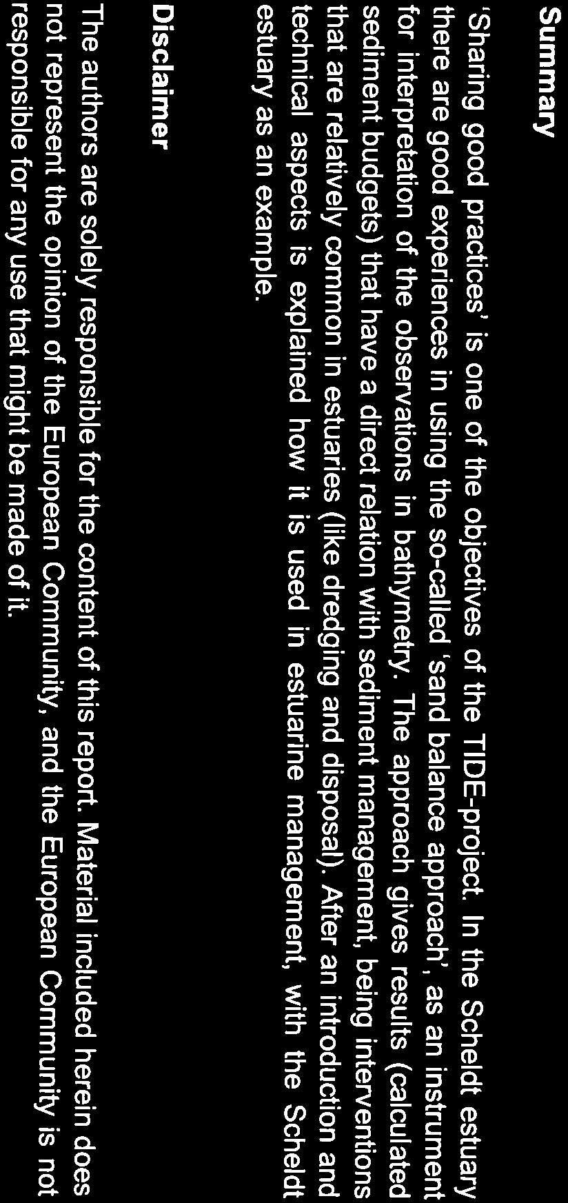
4 1 A sediment approach 1.1 Introduction This document contributes to sharing good practices between the partners of the four TIDEestuaries (Elbe, Humber, Scheldt, Weser), being one of the objectives of the TIDE-project. In the Scheldt estuary there are good experiences in using the so-called sand balance approach as an instrument for interpretation of the observations in bathymetry. This approach uses data that are often reasonably well available (bathymetric data). Its outcomes (calculated sediment budgets) have a direct relation with sediment management and interventions that are relatively common in estuaries (like dredging and disposal). After an introduction and technical aspects is explained how it is used in estuarine management. The sand balance approach is in fact a volume balance, over a specified period and a specified area, of all sediments and objects (including even ship wrecks) that are in and on the water bed. It uses bathymetric measurements to calculate volumes (not mass). Sediments in the water column (and not observed by bathymetric measurements) are not included. In sandy environments (like for instance the Dutch and Flemish coasts) it is mainly changes in sand budgets that are calculated, hence the name sand balance Dynamic stability of estuaries and management issues The physical behavior of an estuary covers hydrodynamics (governed by tide, geometry, river discharge and their mutual interactions) and morphodynamics (governed by hydrodynamics and sediment availability). We observe the trends in hydro- and morphodynamics in order to assess the physical behavior and compare this to policy objectives. Policy objectives determine which states and developments of hydro- and morphodynamics are desired. Often the policy objectives include sustainable development of the estuary. For a tidal basin / estuary the sustainability of the physical behavior means a dynamic stability. This refers to a balance of hydro- and morphodynamical processes, on the various scales of time and space (see 1.3). The assessment of a sediment balance provides information on status and trends in physical behavior and more precise, the sediment budgets. These budgets can be appropriate indicators for policy and management. Preservation of sediment budgets in itself may be a management objective 2. Trends in sediment budgets can indicate whether short and/or long term physical behavior is changing 3. The observed developments can be used to assess the scale and consequences of sediment management (dredging, disposal, sand mining, nourishments) as well as natural 4 changes in bathymetry. 1. Usually we calculate budgets on the assumption that only sediment that can settle has to be taken in account. This and the name itself (sand balance approach) make it easy to neglect the role of fine sediments, which are stored in the water column. This may be true during normal flow, but they tend to settle in low dynamic areas like harbors. 2. For example, for the Dutch coast these budgets (comprising almost only sand) indicate the resilience for climate change and the Dutch coastal policy is based on the maintenance of sand budgets. 3. For example, in the Scheldt estuary, net budgets and transports are used to learn about the functioning of the multiple channel system (see chapter4). 4. Natural refers to sediment transports as result of water movement. These have, of course, not just natural causes as all sorts of human interferences induce changes in hydrodynamics and hydrology. 'Sand' Balance Approach 1 van 15
 of a tidal basin / estuary is governed by tidal asymmetry. When there are stronger currents during flood (ebb) we talk about flood (ebb) dominance.")
5 The morphological development of a basin is the result of (i) sediment demand, (ii) sediment availability and (iii) the ability to transport sediment. The net sediment transport (during a tidal cycle) of a tidal basin / estuary is governed by tidal asymmetry. When there are stronger currents during flood (ebb) we talk about flood (ebb) dominance. This means that there is more transport capacity in flood (ebb) direction. It may occur that an estuary has both areas of flood- and ebb-dominance, depending on the geometry on smaller scales. There is also a feedback mechanism as the tidal characteristics, including the occurrence of flood and ebb dominance, is depending on the morphology. A reliable sand balance requires monitoring results. The budgets are determined out of bathymetric data for predefined areas and periods. This gives insight in the development of the areas and in the relative importance of the various sediment sources and losses, resulting in deposition and erosion. The sand balance approach is used to describe the system and understand development, but not for predicting effects of interventions of natural developments (e.g. future rates of Sea Level Rise). 1.3 Large and small scales of space and time Space AREAS OF INTEREST: One estuary with mouth and river: * Tidal range * Large scale sediment balance Smaller scales * Development intertidal areas * Development channels * Ecological response * Navigation * Safety Middle, East, West Macro-cell Mouth W-Scheldt SeaScheldt Estuary Dutch Flemish Coastal system Shoals, channels Intertidal areas Ripples Time Figure 1: Scales of time and space in an estuary (illustrated using the Scheldt) Figure 1 shows areas of interest, morphological elements and associated scales (time, space) for the Scheldt estuary. Large-scale issues like tidal range and sediment balance cannot be translated straightforward to individual smaller areas. Observed trends in sediment budgets differ often between groups of channels and shoals (called macro cells, a concept that is explained in section 4.2). Such differences between scales of time and space make assessments more complex. 'Sand' Balance Approach 2 van 15
6 The use of mathematical models to estimate the sediment balance out of hydrodynamic processes is developing, but still too limited to give reliable results in complex and dynamic systems like estuaries. Results of a sand balance approach are, on the other hand, of importance in improving and judging numerical tools. It is one of the requirements of morphological modeling that they reproduce the development of sediment budgets sufficiently. 'Sand' Balance Approach 3 van 15
7 2 Determination of sediment budgets 2.1 Procedure and data The sand (sediment) balance is a relatively simple procedure. The budget is determined as a mass balance (in practice: volumes) of sediment that is in/on the waterbed. The time rate of change of the volume of sediment in a compartment is simply the difference between two measurements, which, by definition, must be equal to the result of human interventions and natural transport of sediment. Calculations are done relative to a constant reference plane. V transport = V tot - V i * V transport : The calculated difference between transports into and out of the area during the period. A positive value suggests sedimentation, a negative one suggests erosion. * V tot : the changes in volume, based on measurements * V i : the changes in volume as result of human interventions The results of this procedure, if presented with their variation in time and space, give a relatively detailed image on evolutions and trends in morphological behaviour. The approach requires data on: Variation of bathymetry in time, based on field measurements; Dredging activities, specified in space and time and dredged amounts; Disposal activities, also specified in space and time and amounts; preferably including the relative content of sediments that will suspend (like silt/clay); Possible other interventions that influence the sediment balance, like nourishments and sand mining (but both can be regarded as special variations on dredging and disposal). It also comprises interventions in geometry like embankments and removal of wrecks, as these have impact on the measured bathymetric and hence the calculated volumes. 2.2 Schematization and synchronization The approach requires a schematization, in areas for which the determination of sediment budgets is needed. These schematizations must be made on morphological considerations, and not on, for instance, administrative grounds or on aspects of data-collection. Schematizations should represent the presence of shoals and channels and their development in time. The latter gives an extra complication with the requirement that the coordinates of the areas do not change. A changing schematization makes an interpretation in terms of sediment budget no longer possible. This means that the calculations of sediment budgets on smaller scales can get difficult or even impossible, when morphological elements like channels and shoals change too much in position 5. Changes in surface-area must be taken in account when conclusions are drawn on average depth or height of morphological elements out of the sediment budgets. 2.3 Uncertainties The processes of measurements and synchronization / interpolation introduce all kind of uncertainties on the outcome. The approach uses, for example, data from different sources. These data can vary, in time intervals, in methods of interpolation of data and in used measurement techniques. The importance of the study-results for policy and management requires good insight in all these uncertainties. This is not easy as one has to deal with: 5. Alternative may be to look at changes in hypsometric curves of areas and to derive volume-changes out of these. 'Sand' Balance Approach 4 van 15
8 A lack of insight into the accuracy of the measurements; Lack of spatial resolution: usually very little data is available to derive transport between smaller morphological elements, for instance between shoals and neighboring channels; Methods and techniques have developed during the years, also and especially in the processing following the measurements: there are many human factors left that can introduce errors; The processing and analysis of data, especially from older surveys, can be very laborintensive As illustration: A small change in bed level over a wide shelf area is, for example, equivalent to a large supply or loss of sediment (10 mm erosion over an area of 10x10km2 is equivalent to 1 million m3 of sediment). Only long-running survey programs can deduce such slight but systematic changes of bed levels. Tectonic processes also have implications on the sediment balance, being either natural processes (on geological timescales) or the result of human activities (e.g. gas mining near the Dutch Wadden Sea). These are effects in the same order of magnitude. 'Sand' Balance Approach 5 van 15
9 3 Sediment budgets at different scales of space and time Methodology Coastal and estuarine systems can be studied as interrelated units. For coasts, one can specify littoral cells, which are linked by various transfer processes that operate over different spatial and temporal scales. The units or cells are identified according to morphological and process information and defined as relatively self-contained units within which sediment circulates. Cell and sub-cell boundaries can be defined consistently by identification of discontinuities in rate or direction of sediment transport. These boundaries can be a total barrier for sediment transport, resulting in independent morphological cells over a timescale of decades. Examples of this are barriers to longshore sediment transport, represented by e.g. deep inlets with strong currents, major artificial manmade structures or deep navigation channels that are maintained over long periods. Less strict barriers are also used as boundaries, varying from shallow inlets to so-called transient partial boundaries like spits, sand banks and short breakwaters. For the identification of units in estuaries we may need go one step further and make use of the hydrodynamic conditions (see example of the Scheldt in 4.2). Interpretation for various scales, in relation to policy and management The state and development of sediment budgets can differ on various scales of time and space 6, as well as their meaning for policy and management. It may, for example, be that a total sediment budget shows a constant status and/or trend, while at the same time the distribution of the sediment over smaller morphological elements shows significant changes, which may be related to undesired developments. An important parameter for the evaluation of long term developments can be the total sediment budget and the ability for a system to adapt to sea level rise. On smaller scales the state and trends in sediment budgets may be used to assess stability and development of smaller morphological units: main channels, secondary channels, shoals and intertidal areas (see also chapter 4). For all scales holds: observations must be compared with historical trends and evaluated in the light of policy-objectives. The Scheldt case elaborates this. The focus in this estuary is both (i) on the budgets of smaller units, in light of the preservation of the multiple channel system (as elaboration of dynamic stability and (ii) on large-scale developments in budgets, in light of long term safety and keeping up with sea level rise. 6. See figure 1 for an explanation of scales of time and space 'Sand' Balance Approach 6 van 15
 and")
10 4 Sediment balances for the Scheldt Estuary 4.1 General The Scheldt estuary can, in terms of morphodynamics, be distinguished in: The estuary in Flanders: the Upper Sea Scheldt (stretching from Gent to Rupelmonde, not included in figure 2) and the Lower Sea Scheldt (up to the border) The estuary in the Netherlands: Western Scheldt (from the border to the mouth, usually the line between Vlissingen and Breskens is used within sediment budget calculations) The mouth, stretching North and South along the coastline, usually the towns of Zeebrugge and Westkapelle are used for boundaries. This distinction reflects the different morphological characteristics: a one-channel system (Flanders), a two(multiple) channel system (Netherlands) and the mouth. First some aspects of schematization of the Western Scheldt are discussed (4.2), before results of a sand balance study are shown as an example (4.3). Figure 2: The Scheldt estuary with ebb and flood channels, up to Antwerp. The estuary continues, as the upper Sea Scheldt, until the city of Gent 4.2 History and development-objectives of the Western Scheldt The multiple channel system of the Western Scheldt shows ebb and flood channels with large intertidal flats in between. Numerous stable and/or migrating connecting channels intersect these intertidal flats. The ebb and flood channels join at highly dynamic, shallow areas (including the sills, where a lot of dredging works needs to be done). In this way the channels form six rather distinct topographic units with strong interaction between its morphologic elements (e.g. Van Veen, 1950) and very large gross water and sediment transport rates through their branches. These units are the so-called macro-cells (see Figure 3). This schematization, in a chain of morphological cells, proved to be a useful tool. 'Sand' Balance Approach 7 van 15

11 Figure 3 morphological schematization of the Western Scheldt multiple channel system in a chain of cells The multiple channel system was able to develop itself as a remainder of a period when the estuary was much larger. Centuries ago the channels had to feed and drain large tidal basins along the estuary. A major part of these basins were cut off the estuary by embankments, when they were transformed into polders (usually after a period of sedimentation). The channels lost in that way part of their original function. An accepted hypothesis is that the multiple channel system did not disappear as it became self-preserving, due to the large gross sediment transport rates through the channels and the overall asymmetry of the system (Winterwerp, 2001). The asymmetry results in significant residual transports circulating through the cells, in the flood or ebb direction of the branches. The multiple channel system is, taking the previous in mind, regarded to be in some sort of dynamic equilibrium, on a timescale of decades. On larger timescales geologists describe the stage of the Western Scheldt as one that is somewhere in between a one channel system with bordering flats and a drowned estuary with no intertidal flats 7. These possible endpoints of the morphologic development do not fit within the policy objectives, neither of the Netherlands nor Flanders. The countries both made conservation of the multi-channel system as an important policy objective. This is thought to serve the long term goals for safety, accessibility and system integrity (both non-biotics and ecology) in the best way. Present management aims hence at a balanced combination of dredging, disposal and sand mining, to preserve the physical characteristics of the multiple channel system. A basic hypothesis for management aimed at conservation of the multiple channel system is that the objective can be broken down to smaller scales. This implies that the objective is met if the cell structure of all macro cells is preserved. The stability of the entire multiple channel system is hence studied by analyzing the stability of the individual. Preservation of the large circulating sediment transport capacity through the branches and the overall asymmetry is assumed crucial. The asymmetry between the ebb and flood channel (producing net water level differences over the intertidal flat) is also important, as it is thought to be the driving force for the (re)generation of the connecting channels (Swinkels, 2009). Sediment balances of macro cells (and of smaller morphological units) help to assess whether the development and stability of channels and intertidal flats is at stake. The example of critical thresholds for disposal below illustrates how this can help to evaluate sediment management, without knowing the exact system-functioning. 7. On the geological timescale the sediment availability and demand (most important the one as result of sea level rise) will determine if and how fast the estuary develops towards one of these two endpoints 'Sand' Balance Approach 8 van 15
12 Example: critical thresholds for disposal in a secondary channel There is a threshold on the amount of dredged material for a secondary channel 8 to receive yearly. Above this threshold a channel system in equilibrium will probably become unstable and degenerate. This is a process that occurs at large timescales: decades to centuries. Such long time scales have the risk that only after a long time, when it may be too late, the negative impact (of a disposal strategy) is known. A concept based on transport capacity and autonomous evolution of the macro-cell helps to assess the approximate magnitude of the disposal capacity. An indicative theoretical level of 5% to 10% of the transport capacity is available as an engineering rule, for a first indication of the disposal capacity in systems like the macro cells of the Scheldt estuary. With additional data and verification for a given location and estuary a more detailed evaluation or design of disposal strategies will be possible (see e.g. Wang and Winterwerp, 2001; Jeuken and Wang, 2010). 4.3 Results / observations for the Scheldt estuary For the Scheldt estuary, various reports are available based on the sand balance approach. The most extensive is the report by Haecon (2006, in Dutch), being the first one covering both the Dutch and the Flemish part of the estuary. As an example for the description of the approach, some figures of this study are presented below. Figure 4: Sand balance approach for Sea Scheldt Figures 4 and 5 show typical results of a sand balance study. The blue dashed lines represent the sum of all human interventions. The black lines represent the measured volumes. Adding measured volumes and human interventions results in a calculated net volume change which is, assumed to be the result of transport (the red line, with triangles). For the Sea Scheldt (figure 4) is assumed that there is no net transport over its upstream boundaries. For the Western Scheldt (figure 5) there is net transport upstream, towards the 8. The primary channel is the main channel and can be either the flood or ebb channel. The secondary channel is the other. In the Western Scheldt the ebb channel is the primary channel, except in macro cell 4. 'Sand' Balance Approach 9 van 15
13 Sea Scheldt. This can be derived from figure 4 (red line) and is shown (with a green line) in figure 5. This volume is needed to derive the net transport between Western Scheldt and the mouth of the estuary. Figure 5: Sand balance approach for Western Scheldt Examples of lessons that can be learned from figures 4 and 5: The sediment volumes of both Sea Scheldt and Western Scheldt have decreased, more or less continuous, over the last decades This loss of sediment in the estuary is less than the net result of human interventions There has been a long term trend of import of sediment from West (the mouth) to East (the Sea Scheldt). There may be a change in trend of import from the mouth to the Western Scheldt, occurring around the first half of the 1990 s. Such lessons are based on trends. Sudden changes between years (like e.g in figure 5 before 1970) can easily be the result of uncertainties as described in 2.3. These should regarded with care. Please note that, (i) the sediment transport also reacts on the 18,6 year-period of the tide 9 ; (ii) the uncertainty in the calculation of the net transport between Western Scheldt and the mouth is also depending on the uncertainty in the sediment balance of the Sea Scheldt. 9. The time-lag is, for the Scheldt estuary, approximately 4-5 years (theoretically, but cannot be observed in recent years, probably due to the dominance of all human interventions) 'Sand' Balance Approach 10 van 15
14 - sum of interventions measured volume-change Figure 6: Calculated yearly transports between macro-cells, based on sand balance of Western Scheldt Figure 6 is an example of information of a sand balance study for smaller areas. It shows a longitudinal distribution of the net transports, between macro-cells, averaged over 50 years. In this period, the net transport has been upstream (red arrows). The figure includes the sum of interventions, observations and calculated net transports with neighboring macro-cells. Some macro-cells show more export to the macro-cell upstream than they receive as import from the macro-cell downstream. These cells have sediment budgets that decreased more than the sum of all human interventions. Figures 4 and 5 already showed the magnitude of these interventions and their effect on the large-scale balance. There is no full discussion in this document on the value and interpretation of the results and conclusions of Haecon (2006) for the management of the Scheldt estuary. This would require extensive information, on available system knowledge, developments in policy and management, uncertainties, as well as the evaluation of recent monitoring data. 'Sand' Balance Approach 11 van 15
 balance approach contributes to increased understanding of the system.")
15 5 Contribution to TIDE-objectives 5.1 Proposed link to understandingtide To position this document within the TIDE-project we look at figure 7, especially the left side of it. In chapters 1 4 is explained how a sand (sediment) balance approach contributes to increased understanding of the system. This, in turn, helps to better set objectives for the short and long term (understanding estuary functions). Insight in required sediment budgets (for various functions) and in morphological developments is used in designing measures within sediment management and, more specific, a disposal strategy. The introduction in the application of the approach for the Scheldt estuary (chapter 4) provided an example and best practice. Figure 7: TIDE Inter-relations between various general estuary processes, TIDE activities and expected outputs (derived from memo understanding TIDE, November 2010) 5.2 Using the approach for elaborating objectives Large-scale development and long term safety: Soft coastal systems have the ability to adapt to sea level rise by capturing sediment and growing vertically according the rate of sea level rise. This principle is the basic philosophy of Dutch coastline management. The sand (sediment) balance approach offers tools to calculate the required sediment (on average per year), either by natural transport or by man (e.g. nourishments). This approach can be applied for morphologically interconnected units. 'Sand' Balance Approach 12 van 15
 for the individual channels or shoals? Chapter 4.")
16 Smaller scales: habitats and dynamic stability: To help and preserve the dynamic equilibrium of channels and shoals, the approach is used to study and monitor the natural development. Are changes in trends visible? Which trends are desired or non-desired (increasing or decreasing sediment budgets) for the individual channels or shoals? Chapter 4.2 gave an introduction in the determination of critical thresholds for disposal of sediment in secondary channels. Finally, the sand balance approach also introduces a conceptual model, based on identifying morphologically interrelated units on the relevant scale of time. Such concept is relatively easy to communicate as the basis for sediment management to a wider audience. This holds for a general policy as well as for individual measures. 5.3 Application in dynamic sediment management Dynamic sediment management is based on monitoring the morphological development and adjusting strategies on these observations. The flexible disposal strategy (see TIDE-factsheet and Sas et al, 2011) operationalises this. It tries to combine the freedom that is offered by sediment management (much more reversible than hard measures ) 10 and the possibility to vary the measure along the estuary. We can distinguish four disposal strategies (figure 8): A. In the deepest parts of the primary channel B. In the secondary channels, but in such way that primary and secondary channels stay in balance C. Enlarge intertidal areas D. Bring the sediment outside the macro-cell and/or outside the estuary (incl. sand mining and relocation within the estuary, but over larger distances) Innovations: flexible disposal strategy / integrated sediment management Sand mining D B Secondary channel Disposal? C Intertidal area Disposal in other cells D Main channel Sill (navigation) A Disposal in deep parts Figure 8: schematization of possibilities within a flexible disposal strategy 10. We distinguish hard and soft measures. Structures are typical hard measures. They influence hydrodynamics and/or connectivity of morphological units and, as result, sediment budgets change. Sediment management has a direct influence on sand budgets. 'Sand' Balance Approach 13 van 15
17 The disposal strategies have an influence on two levels: 1. They directly influence the sediment balance of the areas; 2. They change the bathymetry and influence hydrodynamics (flow velocities, tidal asymmetry etc). In this way they can influence the net transport and future sediment balance. A flexible disposal strategy has the choice to vary the disposal within a macro-cell (primary channel, secondary channel or intertidal area) and to adjust on a large-scale (disposal in the same macro-cell, other macro-cells or in adjacent morphological units like the mouth and the coastal zone or combine this with sand mining). Insight in the sediment budgets supports the assessment of the strategies. Dredging and disposal in the same morphological active area (like a macro-cell in the Western Scheldt) will have less impact on the large-scale sediment budgets. Disposal in the primary channel has usually smallest morphological effects, but can lead to increase of dredging volumes. When sediment is brought outside the macro-cell, the morphological effect will depend on the capacity of the receiving unit and the large-scale trends. 'Sand' Balance Approach 14 van 15
18 Literature Van Rijn, L., Principles of Coastal Morphology, Aqua Publications, the Netherlands (1998). Winterwerp, J.C.; Z.B. Wang, M.J.F. Stive, A.A. Arends, C. Jeuken, C. Kuijper, P.M.C. Thoolen. A new morphological schematization of the Western Scheldt estuary, The Netherlands. Proceedings of the 2nd IAHR Symposium on River, Coastal and Estuarine Morphodynamics, 2001, pp Arends, A.A.; J.C. Winterwerp, Morphological management concept for the Western Scheldt. Coastal Zone 01-12th Biennial Conference Proceedings - Cleveland, USA, July 2001 Jeuken, M.C.J.L.; Z.B. Wang, 2010, Impact of dredging and dumping on the stability of ebbflood channel systems. Coastal Engineering vol. 57 pp HAECON (2006). Actualisatie van de zandbalans van de Zee- en Westerschelde. Proses2010: Bergen op Zoom. (in Dutch) J. van Veen. Ebb and flood channel systems in Dutch tidal waters. Tijdschrift Koninklijk Nederlands Aardwetenschappelijk Genootschap, 67, , 1950 (in Dutch). TIDE-factsheet: A New Sediment Disposal Strategy for the Scheldt VNSC (2009), Protocol conditions for Flexible disposal strategy Quality Parameters. Roose F., Y. Plancke and S. Ides (2008). A synthesis on the assessment of an alternative disposal strategy to serve sustainability in the Scheldt estuary, CEDA Dredging Days, Antwerp. M. Sas, R. De Sutter, K. Beirinckx, F. Aerts and G-J Like (2011). Dredging works in the Westerschelde to deepen the navigation channel and to create ecologically valuable areas. CEDA Dredging Days Rotterdam. Swinkels, C.M.; M.C.J.L., Z.B. Wang, R.J. Nicholls (2009). Presence of Connecting Channels in the Western Scheldt Estuary. Journal of Coastal research 'Sand' Balance Approach 15 van 15
Dynamics of the Ems Estuary
 Dynamics of the Ems Estuary Physics of coastal systems Jerker Menninga 0439738 Utrecht University Institute for Marine and Atmospheric research Utrecht Lecturer: Prof. dr. H.E. de Swart Abstract During
Process-based Long Term Morphological Modelling the present state-of-the-art and the way ahead. Dirk-Jan Walstra
 Process-based Long Term Morphological Modelling the present state-of-the-art and the way ahead Dirk-Jan Walstra Deltares Delft Hydraulics Delft University of Technology Les littoraux à l heure du changement
MORPHOLOGICAL DEVELOPMENT OF THE RIF AND THE ENGELSMANPLAAT, AN INTERTIDAL FLAT COMPLEX IN THE FRISIAN INLET, DUTCH WADDEN SEA
 MORPHOLOGICAL DEVELOPMENT OF THE RIF AND THE ENGELSMANPLAAT, AN INTERTIDAL FLAT COMPLEX IN THE FRISIAN INLET, DUTCH WADDEN SEA Z.B. Wang 1 and A.P. Oost 2 The Rif and the Engelsmanplaat form together a
Sediment Connectivity and Exchange in Ameland Inlet
 Sediment Connectivity and Exchange in Ameland Inlet Stuart G. Pearson, Bram C. van Prooijen, Zheng Bing Wang, and Jasper P. Bak January 11 th, 2017 NCK Symposium on Sediment Sorting Study Site: Ameland
A new sediment budget for the Netherlands: the effect of 15 years of nourishing ( )
") A new sediment budget for the Netherlands: the effect of 15 years of nourishing (1991-2005) A new sediment budget for the Netherlands: the effect of 15 years of nourishing (1991-2005) Ad van der Spek
A new sediment budget for the Netherlands: the effect of 15 years of nourishing (1991-2005) A new sediment budget for the Netherlands: the effect of 15 years of nourishing (1991-2005) Ad van der Spek
Prediction of changes in tidal system and deltas at Nakdong estuary due to construction of Busan new port
 Prediction of changes in tidal system and deltas at Nakdong estuary due to construction of Busan new port H. Gm1 & G.-Y. park2 l Department of Civil & Environmental Engineering, Kookmin University, Korea
impact of human interventions on estuarine dynamics regime shifts
 impact of human interventions on estuarine dynamics regime shifts Han Winterwerp Deltares and Delft University of Technology concentration [mg/l] high and low water level [m] rationale for analysis 8 observations
Sediment Exchange between the Dutch Coast and the Tidal Basin Western Scheldt
 University of Southampton Faculty of Engineering, Science and Mathematics School of Civil Engineering and the Environment & School of Ocean and Earth Science Sediment Exchange between the Dutch Coast and
Simulating the large-scale spatial sand-mud distribution in a schematized process-based tidal inlet system model
 DOI: 10.3990/2.196 Simulating the large-scale spatial sand-mud distribution in a schematized process-based tidal inlet system model F. Scheel1,2,3, M. van Ledden1,2, B.C. van Prooijen1 and M.J.F. Stive1
MORPHODYNAMIC PROCESSES IN ESTUARIES COMPARISON OF MARINE AND LIMNIC TIDAL FLATS
 MORPHODYNAMIC PROCESSES IN ESTUARIES COMPARISON OF MARINE AND LIMNIC TIDAL FLATS Thorsten Albers 1, Dagmar Much 2, Nino Ohle 2, Nicole von Lieberman 1, Eva Falke 1 Tidal flat areas in estuaries are affected
Annual transport rates at two locations on the fore-slope.
 Sediment Transport by Currents Fore-slope Sediment transport rates and sediment concentrations were computed from the hydrodynamic model runs as well as from direct measurements of current velocities at
Sediment transport in the Schelde-estuary: A comparison between measurements, transport formula and numerical models
 Sustainable Hydraulics in the Era of Global Change Erpicum et al. (Eds.) 2016 Taylor & Francis Group, London, ISBN 978-1-138-02977-4 Sediment transport in the Schelde-estuary: A comparison between measurements,
TIME-DEPENDENT EFFECTS OF NOURISHMENTS ON SHOREFACE BAR BEHAVIOUR. Abstract
 TIME-DEPENDENT EFFECTS OF NOURISHMENTS ON SHOREFACE BAR BEHAVIOUR Tommer Vermaas 1, Edwin Elias 2, Ad van der Spek 3 and Rena Hoogland 4 Abstract In 2011/2012 a shoreface nourishment was placed at Heemskerk,
SHORELINE AND BEACH PROCESSES: PART 2. Implications for Coastal Engineering
 SHORELINE AND BEACH PROCESSES: PART 2 Implications for Coastal Engineering Objectives of the lecture: Part 2 Show examples of coastal engineering Discuss the practical difficulties of ocean engineering
BUDGET. Investigation of natural sand transport on the Belgian continental shelf
 BUDGET Investigation of natural sand transport on the Belgian continental shelf Funded by Federal Office for Scientific, Technical and Cultural Affairs Program: Sustainable Management of the North Sea
SEDIMENT IMPORT BY TIDAL INLETS SEDBOX -model for tidal inlets Marsdiep and Vlie, Wadden sea, The Netherlands by L.C. van Rijn
 SEDIMENT IMPORT BY TIDAL INLETS SEDBOX -model for tidal inlets Marsdiep and Vlie, Wadden sea, The Netherlands by L.C. van Rijn 1. Physical processes of sandy tidal inlet systems 1.1 Introduction 1.2 Hydrodynamics
Mangrove Erosion in the Mekong delta
 Mangrove Erosion in the Mekong delta 1. Introduction a. Mangrove coast - a balance between different forcing factors Mangroves are coastal environments frequently observed in the tropical muddy coasts.
MODELLING OF SEDIMENTATION OF DREDGED TRENCHES AND CHANNELS UNDER THE COMBINED ACTION OF TIDAL CURRENTS AND WAVES
 MODELLING OF SEDIMENTATION OF DREDGED TRENCHES AND CHANNELS UNDER THE COMBINED ACTION OF TIDAL CURRENTS AND WAVES D.J.R. Walstra 1, L.C. Van Rijn 1, S.E. Hoogewoning 2, S.G.J. Aarninkhof 1 Abstract: The
SUPPLEMENTARY INFORMATION
 SUPPLEMENTARY INFORMATION DOI: 10.1038/NCLIMATE1664 Climate-change impact assessment for inlet-interrupted coastlines ROSHANKA RANASINGHE 1,2,3*, TRANG MINH DUONG 1,3, STEFAN UHLENROOK 1,2, DANO ROELVINK
BYPASS IN GROYNE FIELDS: CASE STUDY ALONG THE LOBITO SPIT
 BYPASS IN GROYNE FIELDS: CASE STUDY ALONG THE LOBITO SPIT Sten Esbjørn Kristensen 1, Nils Drønen 2, Rolf Deigaard 3, Berry Elfrink 4 Abstract The Lobito spit, in Angola, is fronted by a groyne field along
PRESENTATION TITLE. Regional Sediment Management Application of a Coastal Model at the St. Johns River Entrance BUILDING STRONG
 PRESENTATION TITLE Regional Sediment Management Application of a Coastal Model at the St. Johns River Entrance Steven Bratos Senior Coastal Engineer U.S. Army Corps of Engineers Jacksonville District February
Appendix O. Sediment Transport Modelling Technical Memorandum
 Appendix O Sediment Transport Modelling Technical Memorandum w w w. b a i r d. c o m Baird o c e a n s engineering l a k e s design r i v e r s science w a t e r s h e d s construction Final Report Don
Donald K. Stauble and Bill Birkemeier Coastal and Hydraulics Laboratory US Army Corps of Engineers
 Donald K. Stauble and Bill Birkemeier Coastal and Hydraulics Laboratory US Army Corps of Engineers Define the Problem Navigation Shore Protection Environmental Political So what is the problem? Management
A lithological map created from multibeam backscatter data in challenging circumstances: the Lower Sea Scheldt estuary
 A lithological map created from multibeam backscatter data in challenging circumstances: the Lower Sea Scheldt estuary Mieke Mathys*, Marc Sas*, Frederik Roose** HYDRO12, Rotterdam, 15/11/2012 *International
Michael Walsworth, Ryan Sullivan, Simi Odueyungbo, William Budd
 Michael Walsworth, Ryan Sullivan, Simi Odueyungbo, William Budd Estuarine Environment At first (Pritchard, 1967), an estuary was defined by the salinity of the water. Then by Clifton (1982) as an inlet
MACRO-SCALE MORPHOLOGICAL CHARACTERISATION
 MACRO-SCALE MORPHOLOGICAL CHARACTERISATION OF THE WESTERN SCHELDT July 2002 Marco Toffolon E-mail: marco.toffolon@ing.unitn.it Dipartimento di Ingegneria Civile e Ambientale (Dept. of Civil and Environmental
Morphodynamic Response of Tidal Mudflats to Marine Cohesive Sediment Influx
 Morphodynamic Response of Tidal Mudflats to Marine Cohesive Sediment Influx Wongsoredjo Samor Master of Science in Earth Sciences Thesis Utrecht, 2016 Utrecht University, Faculty of Geosciences Morphodynamic
SEDIMENT TRANSPORT IN RIVER MOUTH ESTUARY
 SEDIMENT TRANSPORT IN RIVER MOUTH ESTUARY Katsuhide YOKOYAMA, Dr.Eng. dredge Assistant Professor Department of Civil Engineering Tokyo Metropolitan University 1-1 Minami-Osawa Osawa, Hachioji,, Tokyo,
Longitudinal dams as an alternative to wing dikes in river engineering. Fredrik Huthoff
 Longitudinal dams as an alternative to wing dikes in river engineering Fredrik Huthoff Contents Introduction Why consider longitudinal dams? Room for the river in the Netherlands The pilot study The Dutch
delft hydraulics Morphodynamic network simulations of the Westerschelde Rijkswaterstaat Rijkslnslituut voor Kust en Zee/RIKZ Bibllolhook (Middolburg)
") Rijkswaterstaat Rijkslnslituut voor Kust en Zee/RIKZ Bibllolhook (Middolburg) Morphodynamic network simulations of the Westerschelde R.J, Fokkink delft hydraulics delft hydraulics CLIENT :Directoraat-Generaal
Rijkswaterstaat Rijkslnslituut voor Kust en Zee/RIKZ Bibllolhook (Middolburg) Morphodynamic network simulations of the Westerschelde R.J, Fokkink delft hydraulics delft hydraulics CLIENT :Directoraat-Generaal
The Systems Approach. Alun Williams, ABPmer
 The Systems Approach Alun Williams, ABPmer Overview What is A Systems Approach? Behavioural / Qualitative Modelling? System Definition / Mapping (Behavioural Statements Objective) What is a Systems Approach?
SEDIMENT MANAGEMENT CONCEPT OF THE PORT OF HAMBURG
 International Conference - Karlsruher Flussgebietstage 2013 62 SEDIMENT MANAGEMENT CONCEPT OF THE PORT OF HAMBURG Axel Netzband Contact: Axel Netzband Hamburg Port Authority Neuer Wandrahm 4 20457 Hamburg
Coastal Sediment Properties and Longshore Sediment Transport
 Coastal Sediment Properties and Longshore Sediment Transport Julie Rosati Julie.D.Rosati@erdc.usace.army.mil 601-634-3005 Coastal Planning Course Lesson #8 Tuesday 8:00-9:00 am CEM III-1, III-2 1. Coastal
Del Mar Sediment Management Study
 Del Mar Sediment Management Study Shoreline Preservation Working Group, June 7, 2018 Lindsey Sheehan Current work in Del Mar 2016 Sea-Level Rise Vulnerability Assessment 2018 Adaptation Plan 2018 Sediment
Decline of Lake Michigan-Huron Levels Caused by Erosion of the St. Clair River
 Decline of Lake Michigan-Huron Levels Caused by Erosion of the St. Clair River W.F. & Associates Coastal Engineers (in association with Frank Quinn) April 13, 2005 Outline Problem Definition Understanding
The Coast: Beaches and Shoreline Processes
 1 2 3 4 5 6 7 8 9 The Coast: es and Shoreline Processes Trujillo & Thurman, Chapter 10 Oceanography 101 Chapter Objectives Recognize the various landforms characteristic of beaches and coastal regions.
The Coast: Beaches and Shoreline Processes Trujillo & Thurman, Chapter 10
 The Coast: es and Shoreline Processes Trujillo & Thurman, Chapter 10 Oceanography 101 Chapter Objectives Recognize the various landforms characteristic of beaches and coastal regions. Identify seasonal
June 2018 Sediments and Dredging at GBR Ports
 June 2018 Sediments and Dredging at GBR Ports Reef 2050 Long Term Sustainability Plan The Great Barrier Reef is over 2000 km long and covers an area of approximately 350,000 square kilometres. It is a
Understanding and Managing Morphological Change in Estuaries
 PRESENTATION OF FINDINGS This chapter: Explores ways in which the findings from coastal studies can be communicated to others and provides a number of worked examples of the techniques outlined; Reviews
Securing Manoeuverability of a Deep Draft Ship in a Sediment loaded Tidal River Berth
 Securing Manoeuverability of a Deep Draft Ship in a Sediment loaded Tidal River Berth O. Stoschek 1, A. Matheja 1 & C. Zimmermann 1 1 Franzius-Institute for Hydraulic, Waterways and Coastal Engineering,
Dynamic preservation of the coastline
 Dynamic preservation of the coastline Content Introduction The Dutch coastal defence by dynamic processes Data collection Management of the sand resources Growing importance of marine sand and gravel resources
Climate change and socio-economic impact on the long term sediment balance in the Belgian Part of the North Sea
 Climate change and socio-economic impact on the long term sediment balance in the Belgian Part of the North Sea De Sutter Renaat, Ghent University & IMDC Van Lancker Vera, Fettweis Michael, Van den Eynde
Appendix G.19 Hatch Report Pacific NorthWest LNG Lelu Island LNG Maintenance Dredging at the Materials Offloading Facility
 Appendix G.19 Hatch Report Pacific NorthWest LNG Lelu Island LNG Maintenance Dredging at the Materials Offloading Facility Project Memo H345670 To: Capt. David Kyle From: O. Sayao/L. Absalonsen December
Predicting the implications of tidal energy barrages: the use of analogues in exploring environmental issues
 Predicting the implications of tidal energy barrages: the use of analogues in exploring environmental issues Roger Morris Bright Angel Coastal Consultants Structure of this presentation Introduction to
The Imperative of Sediment Management Concepts in River Basin Management Plans
 The Imperative of Sediment Management Concepts in River Basin Management Plans Stefan Vollmer, Thomas Hoffmann, Gudrun Hillebrand, Ina Quick, Axel Winterscheid Department M3 Groundwater, Geology, River
Hydrodynamics in Shallow Estuaries with Complex Bathymetry and Large Tidal Ranges
 DISTRIBUTION STATEMENT A: Approved for public release; distribution is unlimited. Hydrodynamics in Shallow Estuaries with Complex Bathymetry and Large Tidal Ranges Stephen G. Monismith Dept of Civil and
Morphological Modeling of Inlets and Adjacent Shorelines on Engineering Timescales
 CB&I Morphological Modeling of Inlets and Adjacent Shorelines on Engineering Timescales Challenges and Model Improvements based on Recent Studies Dobrochinski, J.P.H.; Benedet, L.; Signorin, M.; Pierro,
THE SETTLING OF MUD FLOCS IN THE DOLLARD ESTUARY, THE NETHERLANDS
 THE SETTLING OF MUD FLOCS IN THE DOLLARD ESTUARY, THE NETHERLANDS SUMMARY Chapter 1 Introduction and literature review Morphological changes of estuarine channels and tidal flats depend on erosion, sediment
The use of MIKE21 to study the. barrier beach system of Inner Dingle Bay, Co. Kerry, Ireland. Dr. Michael O Shea Malachy Walsh and Partners
 The use of MIKE21 to study the morphodynamic evolution of the mid-bay barrier beach system of Inner Dingle Bay, Co. Kerry, Ireland Dr. Michael O Shea Malachy Walsh and Partners Contents Why Study Morphodynamics
Sediments in a changing Environment Ecological implications of dredging and relocation in the Elbe estuary Günther Eichweber, WSD-Nord
 Sediments in a changing Environment Ecological implications of dredging and relocation in the Elbe estuary Günther Eichweber, WSD-Nord 2011-04-07 S1 Basic problem: sediment budget out of equilibrium 2011-04-07
Development and application of demonstration MIKE 21C morphological model for a bend in Mekong River
 Development and application of demonstration MIKE 21C morphological model for a bend in Mekong River September 2015 0 Table of Contents 1. Introduction... 2 2. Data collection... 3 2.1 Additional data...
L7/ Historical Perspec=ve, Deltas
 Colin Woodroffe (2002) Coasts: Form, Process and Evolu=on, Outline of Chapter 7: L7/1 L7/2 7.1. Historical Perspec=ve, 7.1.1. Deltas Herodotus (450, B.C.) delta = Shape of Nile River Delta = Δ Gilbert
Tarbela Dam in Pakistan. Case study of reservoir sedimentation
 Tarbela Dam in Pakistan. HR Wallingford, Wallingford, UK Published in the proceedings of River Flow 2012, 5-7 September 2012 Abstract Reservoir sedimentation is a main concern in the Tarbela reservoir
N. von Lieberman 1 and T. Albers 2
 MORPHODYNAMIC DEVELOPMENT OF TIDAL FLATS by N. von Lieberman 1 and T. Albers 2 ABSTRACT The tidal flats of the German North Sea coast are affected by intense morphodynamics. Especially in the mouths of
RESULTS FROM THE TEXAS COASTAL SEDIMENT SOURCES: A GENERAL EVALUATION STUDY
 RESULTS FROM THE TEXAS COASTAL SEDIMENT SOURCES: A GENERAL EVALUATION STUDY JUAN MOYA KELSEY CALVEZ CRIS WEBER ANTHONY RISKO *KEVIN FRENZEL FREESE AND NICHOLS, INC. COASTAL AND WATERWAYS GROUP OBJECTIVES
DP2.8 The December 2013 storm. lessons In Flanders learned in Belgium
 DP2.8 The December 2013 storm Lessons Learned December Storm lessons In Flanders learned in Belgium Tidal Scheldt Sigmaplan Flemish Coast Coastal Safety Master Plan Lessons learnt Patrik Peeters Kathleen
Environmental impact assessment study of the new offshore dumping sites for Šventoji port in Lithuania
 Environmental impact assessment study of the new offshore dumping sites for Šventoji port in Lithuania Introduction Summary In 2003 Lithuanian Ministry of Transport initiated the preparation of feasibility
KEYWORDS: erosion shoreline change nourishment community issues
 UNC Coastal Studies Institute 1 TITLE: Sand, Soil, Sediment Selection for Beach Nourishment KEYWORDS: erosion shoreline change nourishment community issues ABSTRACT: North Carolina s barrier islands are
WESTERN SCHELDT ESTUARY (THE NETHERLANDS)
") WESTERN SCHELDT ESTUARY (THE NETHERLANDS) Contact: Paul SISTERMANS Odelinde NIEUWENHUIS DHV group 36 Laan 1914 nr.35, 3818 EX Amersfoort PO Box 219 3800 AE Amersfoort The Netherlands Tel: +31 (0)33 468
WESTERN SCHELDT ESTUARY (THE NETHERLANDS) Contact: Paul SISTERMANS Odelinde NIEUWENHUIS DHV group 36 Laan 1914 nr.35, 3818 EX Amersfoort PO Box 219 3800 AE Amersfoort The Netherlands Tel: +31 (0)33 468
TIDAL FLAT EVOLUTION AT THE CENTRAL JIANGSU COAST, CHINA
 Proceedings of the Sixth International Conference on Asian and Pacific Coasts (APAC 211) December 14 16, 211, Hong Kong, China TIDAL FLAT EVOLUTION AT THE CENTRAL JIANGSU COAST, CHINA Z. GONG State Key
A Quantitative Assessment of Human Interventions and Climate Change on the West African sediment budget
 Public Disclosure Authorized Public Disclosure Authorized A Quantitative Assessment of Human Interventions and Climate Change on the West African sediment budget Public Disclosure Authorized The West African
Research Topic Updated on Oct. 9, 2014
 Research Topic Updated on Oct. 9, 204 Mixed Cohesive/Non-cohesive Sediments Sedimentation in Estuary: Flocculation Deposition Erosion Transport Consolidation *: It has been recognized that when the fraction
Supplemental Slides. Shore: Junction of Land & Water. Junction of Land & Water. Sea Level Variations. Shore vs. Coast. Sea Level Variations
 Shore: Junction of Land & Water Supplemental Slides Sediments come off land Most get dumped at the beach Sediment interacts with ocean waves and currents Junction of Land & Water Features: Breaking waves,
Shore: Junction of Land & Water. Sediments come off land Most get dumped at the beach Sediment interacts with ocean waves and currents
 Shore: Junction of Land & Water Supplemental Slides Sediments come off land Most get dumped at the beach Sediment interacts with ocean waves and currents Junction of Land & Water Features: Breaking waves,
INTEGRATED COASTAL SEDIMENT MANAGEMENT AT PHYSIOGRAPHIC UNIT SCALE, AN APPLICATION IN VERSILIA LITTORAL (TUSCANY, ITALY)
") INTEGRATED COASTAL SEDIMENT MANAGEMENT AT PHYSIOGRAPHIC UNIT SCALE, AN APPLICATION IN VERSILIA LITTORAL (TUSCANY, ITALY) Damiano Scarcella (Msc) Sergio Cappucci (PhD) Andrea Taramelli (PhD) OUTLINE Sediment
INTEGRATED COASTAL SEDIMENT MANAGEMENT AT PHYSIOGRAPHIC UNIT SCALE, AN APPLICATION IN VERSILIA LITTORAL (TUSCANY, ITALY) Damiano Scarcella (Msc) Sergio Cappucci (PhD) Andrea Taramelli (PhD) OUTLINE Sediment
DUNE EROSION NEAR SEA WALLS: MODEL-DATA COMPARISON
 DUNE EROSION NEAR SEA WALLS: MODEL-DATA COMPARISON Pieter van Geer 1, Bram de Vries 2, Ap van Dongeren 1 and Jaap van Thiel de Vries 1,2 This paper describes the validation of the dune erosion model XBeach
Effects of possible land reclamation projects on siltation in the Rotterdam harbour area. A model study.
 Effects of possible land reclamation projects on siltation in the Rotterdam harbour area. A model study. J.M. de Kok
Possibility of Reducing Sedimentation at Lateral Diversion
 Available online at www.scholarsresearchlibrary.com Annals of Biological Research, 212, 3 (5):2545-2554 (http://scholarsresearchlibrary.com/archive.html) ISSN 976-1233 CODEN (USA): ABRNBW Possibility of
Primer on Coastal Erosion And Habitat Creation
 2 nd Regional Conference Dredging, Beach Nourishment & Bird Conservation Primer on Coastal Erosion And Habitat Creation Timothy Kana Ph.D Source: Newsday 1962 Photo by Kelsey Aerials 1978 Source: U Mass
Protection of Coasts
 Protection of Coasts [Coastal Zones] Jan van de Graaff Delft University of Technology 1 Coastal Zone: many definitions here: rather narrow strip of land adjacent to sea or large inland water (say: 150
Winfried Siefert ; Volker Barthel**' and
 CHAPTER 176 THE GERMAN "MORAN" PROJECT by Winfried Siefert ; Volker Barthel**' and Abstract The project "MORAN" (Morphological Analyses of the North- Sea-Coast) is an extensive program in order to try
Flood Risk Mapping and Forecasting in England
 Flood Risk Mapping and Forecasting in England Mark Franklin Environment Agency, England NORDESS Workshop on Risk Assessment and Acceptable Risk Outline Flood risk in England Who we are and how we work
ESTUARINE AND COASTAL SEDIMENTATION PROBLEMS 1
 ESTUARINE AND COASTAL SEDIMENTATION PROBLEMS 1 Leo C. van Rijn Delft Hydraulics and University of Utrecht, The Netherlands. E mail: leo.vanrijn@wldelft.nl Abstract: This Keynote Lecture addresses engineering
Environmental Implications A Case Study
 Grain Size Variations and Its Environmental Implications A Case Study DR PURANDARA BEKAL SCIENTIST, NATIONAL INSTITUTE OF HYDROLOGY HARD ROCK REGIONAL CENTER HANUMAN NAGAR BELGAUM, KARNATAKA Particle Transport
Geol 117 Lecture 18 Beaches & Coastlines. I. Types of Coastlines A. Definition:
 I. Types of Coastlines A. Definition: 1. Shore = narrow zone where ocean meets land (e.g. beach) 2. Coast is a broad area where both ocean and land processes act a. Includes onshore marshes, dunes, sea
Long-term morphodynamic evolution and energy dissipation in a coastal plain, tidal embayment
 JOURNAL OF GEOPHYSICAL RESEARCH, VOL. 113,, doi:10.1029/2007jf000898, 2008 Long-term morphodynamic evolution and energy dissipation in a coastal plain, tidal embayment M. van der Wegen, 1 Zheng Bing Wang,
High Resolution Numerical Models of Tidal Marshes in the Delaware Bay
 High Resolution Numerical Models of Tidal Marshes in the Delaware Bay Ramona Stammermann Dept. of Civil, Architectural & Environmental Engineering, Drexel University, Philadelphia, PA Michael Piasecki
Solutions to Flooding on Pescadero Creek Road
 Hydrology Hydraulics Geomorphology Design Field Services Photo courtesy Half Moon Bay Review Solutions to Flooding on Pescadero Creek Road Prepared for: San Mateo County Resource Conservation District
Mud dynamics in the Eems- Dollard, phase 2. Setup sediment transport models
 Mud dynamics in the Eems- Dollard, phase 2 Setup sediment transport models Mud dynamics in the Eems-Dollard, phase 2 Setup sediment transport models Bas van Maren Julia Vroom Luca Sittoni Thijs van Kessel
HRPP 423. Past and future evolution in the Thames Estuary. Kate Rossington and Jeremy Spearman
 HRPP 423 Past and future evolution in the Thames Estuary Kate Rossington and Jeremy Spearman Reproduced from a paper presented at: Reproduced from a paper published in: Ocean Dynamics Volume 59 PAST AND
Improvement of navigation conditions on the Danube (Calarasi-Braila and Lower Danube) - Ecological concerns?
 - Ecological concerns?") Improvement of navigation conditions on the Danube (Calarasi-Braila and Lower Danube) - Ecological concerns? Georg Rast, Christine Bratrich, Orieta Hulea WWF Germany/DCPO Topics of the presentation Major
Improvement of navigation conditions on the Danube (Calarasi-Braila and Lower Danube) - Ecological concerns? Georg Rast, Christine Bratrich, Orieta Hulea WWF Germany/DCPO Topics of the presentation Major
3.3 Classification Diagrams Estuarine Zone Coastal Lagoons References Physical Properties and Experiments in
 Contents 1 Introduction to Estuary Studies... 1 1.1 Why to Study Estuaries?.... 1 1.2 Origin and Geological Age... 4 1.3 Definition and Terminology... 7 1.4 Policy and Actions to Estuary Preservation....
Analysis of coarse sediment connectivity in semiarid river channels
 Sediment Transfer tlirongh the Fluviai System (Proceedings of a symposium held in Moscow, August 2004). IAHS Publ. 288, 2004 269 Analysis of coarse sediment connectivity in semiarid river channels J. M.
Numerical Simulation of Hydrodynamic for Abrupt Bathymetry in Palu River Estuary
 Indian Journal of Science and Technology, Vol 10(29), DOI: 10.17485/ijst/2017/v10i29/116502, August 2017 ISSN (Print) : 0974-6846 ISSN (Online) : 0974-5645 Numerical Simulation of Hydrodynamic for Abrupt
Tidal changes in the Lower Ems ( ): reconstructing the effects of channel deepening and bottom roughness
: reconstructing the effects of channel deepening and bottom roughness") Tidal changes in the Lower Ems (1945-2005): reconstructing the effects of channel deepening and bottom roughness BSc thesis Marjolijn Schoemans Utrecht University; Faculty of Geosciences; Department of
Tidal changes in the Lower Ems (1945-2005): reconstructing the effects of channel deepening and bottom roughness BSc thesis Marjolijn Schoemans Utrecht University; Faculty of Geosciences; Department of
Monitoring of sediment dynamics during disposal of dredged harbour sediment in Port of Esbjerg, Denmark
 Monitoring of sediment dynamics during disposal of dredged harbour sediment in Port of Esbjerg, Denmark Ulrik Lumborg, DHI Jacob Vested, DHI Signe Marie Ingvardsen, Kystdirektoratet Agenda Port of Esbjerg
3.0 ROBERTS BANK TIDAL FLAT MORPHOLOGY
 Vancouver Port Authority Northwest Hydraulic Consultants Ltd. /Triton Consultants Ltd. Roberts Bank Container Expansion File: 33863 Coastal Geomorphology Study - 19 - November 2004 3.0 ROBERTS BANK TIDAL
Teacher s Pack Key Stage 3 GEOGRAPHY
 Teacher s Pack Key Stage 3 GEOGRAPHY Geography Key Stage 3 Fieldwork Worksheet Rivers: 1. Is the water fresh or salty? (test its resistance or specific gravity) 2. Do you know where the water is coming
WORKSHOP #2 [Modeling and Sediment Transfers Review of alternative solutions] Bucharest 07 October 2015
![WORKSHOP #2 [Modeling and Sediment Transfers Review of alternative solutions] Bucharest 07 October 2015](/thumbs/82/85703998.jpg "WORKSHOP #2 [Modeling and Sediment Transfers Review of alternative solutions] Bucharest 07 October 2015") STUDIU DE FEZABILITATE PENTRU SOLUŢII TEHNICE ALTERNATIVE/COMPLEMENTARE PRIVIND LUCRĂRILE CE SE VOR EXECUTA ÎN PUNCTUL CRITIC 01 BALA DIN CADRUL PROIECTULUI ÎMBUNĂTĂŢIREA CONDIŢIILOR DE NAVIGAŢIE PE DUNĂRE
STUDIU DE FEZABILITATE PENTRU SOLUŢII TEHNICE ALTERNATIVE/COMPLEMENTARE PRIVIND LUCRĂRILE CE SE VOR EXECUTA ÎN PUNCTUL CRITIC 01 BALA DIN CADRUL PROIECTULUI ÎMBUNĂTĂŢIREA CONDIŢIILOR DE NAVIGAŢIE PE DUNĂRE
FAILURES IN THE AMAZON RIVERBANKS, IQUITOS, PERU
 FAILURES IN THE AMAZON RIVERBANKS, IQUITOS, PERU A.Carrillo-Gil University of Engineering & A.Carrillo Gil S.A.,Consulting Engineering,Lima,Peru L. Dominguez University of Engineering,Lima & The Maritime
Sediment management: a european perspective. Piet den Besten Centre for Water Management Rijkswaterstaat, Netherlands
 Sediment management: a european perspective Piet den Besten Centre for Water Management Rijkswaterstaat, Netherlands Content Background of Dutch-German exchange (DGE plus) What is needed for adequate sediment
Term Knowledge Using and applying Grade Criteria Autumn 1 Assessment window October Natural hazards pose major risks to people and property.
 Assessment Schedule Year 9 2015/6 Term Knowledge Using and applying Grade Criteria Autumn 1 Assessment window October 2015 3.1.1.2 Tectonic Natural hazards pose major risks to people and property. Definition
SEGMENTED BREAKWATERS AND THEIR USE IN COASTAL LOUISIANA
 SEGMENTED BREAKWATERS AND THEIR USE IN COASTAL LOUISIANA Prepared by: Louisiana Coastal Protection and Restoration Authority Engineering Division March 2016 The geology of Louisiana s coastal zone is intimately
Planning for the Future of Humboldt Bay: Sea Level Rise, Sediment Management, Sand Spits and Salt Marshes. Joel Gerwein
 Planning for the Future of Humboldt Bay: Sea Level Rise, Sediment Management, Sand Spits and Salt Marshes Joel Gerwein Introduction to Humboldt Bay Setting Economy, community, and environment Sediment
Deposition and Resuspension of Sediments in Near Bank Water Zones of the River Elbe
 9th International Congress on Environmental Modelling and Software Brigham Young University BYU ScholarsArchive 4th International Congress on Environmental Modelling and Software - Barcelona, Catalonia,
The Marine Environment
 The Marine Environment SECTION 16.1 Shoreline Features In your textbook, read about erosional landforms, beaches, estuaries, longshore currents, and rip currents. For each statement below, write or. 1.
Holocene Sediments of the Rhine-Meuse-Scheldt Estuaries as Aids to Interpret Tidal and Fluvial-Tidal Deposits in Outcrop and Core*
 Holocene Sediments of the Rhine-Meuse-Scheldt Estuaries as Aids to Interpret Tidal and Fluvial-Tidal Deposits in Outcrop and Core* Allard W. Martinius 1 and J.H. (Janrik) van den Berg 2 Search and Discovery
MORPHOLOGICAL MODELLING OF ARTIFICIAL SAND RIDGE NEAR HOEK VAN HOLLAND, THE NETHERLANDS. L.C. van Rijn, D.J.R. Walstra and P.K.
 MORPHOLOGICAL MODELLING OF ARTIFICIAL SAND RIDGE NEAR HOEK VAN HOLLAND, THE NETHERLANDS L.C. van Rijn, D.J.R. Walstra and P.K. Tonnon Delft Hydraulics, P.O. Box 177, 2700 MH Delft, The Netherlands. leo.vanrijn@wldelft.nl
The Marine Environment
 The Marine Environment SECTION 16.1 Shoreline Features In your textbook, read about erosional landforms, beaches, estuaries, longshore currents, and rip currents. For each statement below, write true or
Sediment Traps. CAG Meeting May 21, 2012
 Sediment Traps CAG Meeting May 21, 2012 Agenda Background Fundamentals of Sediment Transport Sediment Trap Existing Information Next Steps 2 The Site Saginaw River 22 mile river beginning at confluence