Flood Risk Mapping and Forecasting in England
|
|
|
- Polly Rose
- 5 years ago
- Views:
Transcription
1 Flood Risk Mapping and Forecasting in England Mark Franklin Environment Agency, England NORDESS Workshop on Risk Assessment and Acceptable Risk

2


3 Outline Flood risk in England Who we are and how we work Understanding risk Managing risk Responding to incidents
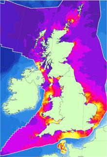
4 Flooding in England ~2.5m properties at risk of flooding from rivers and the sea ~1m of these are in Coastal Areas ~3m at risk of flooding from surface water


5 Who we are and how we work: governance Flood & coastal erosion risk management (FCRM) policy & research Department for Communities and Local Government Local councils (coastal erosion management), spatial planning Regulator: water, waste, carbon, biodiversity Operator: FCRM strategy, mapping & modelling, warning & informing, incident management, partnership working, direct investment (river & sea flooding) & budget management Adviser: policy development and delivery Marine spatial planning, marine licensing & management Biodiversity adviser and regulator, including designated sites 5


6 Who we are and how we work: strategic FCRM planning at the coast National FCRM Strategy Shoreline Management Plans Coastal / Estuary Strategies Projects Update scheduled Mid-term reviews, risk analysis Thames Estuary, Humber, Exe, Cumbria Clacton, Dawlish 6
7 Understanding risk: mapping, modelling & data Updating our National Flood Risk Assessment Coastal Flood Boundary data set improvements Updates to National Coastal Erosion Maps Coastal Hazard Mapping Modelling standards in large estuaries and open coasts icoasst Wave ensemble modelling Other research priorities
8 Understanding risk: a renewed coastal focus 8

9 Understanding risk: key initiatives (1) National Flood Risk Assessment Data improvements from Met Office Wave Watch III 34 year hindcast, sea defence asset data from Asset Information Management System and new Surf Zone Digital Terrain Model Modelling improvements to joint probability, wave transformation and overtopping models Coastal Flood Boundary data Updates to spatially consistent set of sea levels, uncertainty data and design surge profiles using new data from coastal monitoring. Coastal Erosion data Updates to nationally consistent coastal erosion projections using local authority information and tested methodology, with public facing maps.

10 Understanding risk: key initiatives (2) Major Incident Ready Programme H19 East Coast review Coastal modelling standards Coastal Hazard Maps Inter-operability: guidelines and training Gap analysis Consistency in modelling and visualisation Helen Colyer: Project Manager 10

 future combination with real time in situ")
11 Understanding risk: key initiatives (3) Integrated Coastal Sediment Systems (icoasst) Coastal & Estuarine Systems Maps Coastal State Indicators evaluation Model improvements: ASMITA, UnaLinea and SCAPE+ New models: ESTEEM and Meso-I Model linkage demonstrations Wave ensemble modelling improvements probabilistic tide/surge water level plus sea state operational Ensemble Prediction System (EU FP7 Mywave ) future combination with real time in situ observation data 11
12 Understanding risk: other research activities Better understanding and management of mixed beaches Improvements to the Eurotop manual Innovation in beach recharge techniques Synthesising analytical approaches to sediment budgets Effective management of defence toe structures


13 Managing risk: planning (1) Humber strategy update 400,000 people below the 5m contour, billions at risk 2007 approved strategy including 323million 25 year expenditure and strategic approach to habitat creation New legislation (2010), Partnership Funding (2012) and tidal surge (2013: 40km defences overtopped, 7,000ha flooded) Revised strategy incorporates mathematical modelling for decision support, new site investigation techniques and green infrastructure 13

14 Managing risk: planning (2) Thames Estuary Asset Management TE2100 plan involves 3.2billion investment in first forty years First 10 years of delivery being taken forward by integrated specialist team Thames Barrier: APF 0.7% assuming 5 times annual closure. By 2070, 70 times annual closure Downstream exposure of asset system, upstream complex composite structures Towards an ISO55000 accredited optimised replacement and adaptation regime 14
, infrastructure and SPA bird communities (numbering")
15 Managing risk: practising (1) Dawlish Scenario planning for 25km stretch of strategic south west rail network (built 1840) Sand spit recharge using dredge from local ebb delta Re-activation of dune processes and removal of damaging assets Improved storm sheltering for Exe estuary communities (2900 properties), infrastructure and SPA bird communities (numbering 93,000) 15

16 Managing risk: practising (2) Clacton on Sea, Essex 36 million to protect over 3,000 homes over 100 years Partnership funding: 4 million combined local authority funding, 0.5million Growth Fund 23 fish tail rock groynes, 950,000m 3 beach recharge Towards regeneration 16
17

18 Forecasting in England

19 National Forecasting service 7 Centres provide services to Areas Thames Barrier


20 BAU 3 2 Months 1 Month 10 to 6 days 5 to 2 days up to 2 days - Resilience rostering - Scenario planning - Exercising - Dredging Tone Setting Assess and prepare - Asset contingency plan - Kit deployment planning - Community relations Pre-emptive media brief Planning and prepare - Pre-emptive MP brief - Focussed scenario planning - National Planning cell - Media briefing Planning & Response - COBR - NOIMT - Focussed planning - Pre-emptive MP brief - Media briefings Response & Recovery - All cells activated - NOIMT / COBR - Check asset conditions - Mutual aid - Requests to move kit - Big comms - Recovery phase plan Response & Recovery - SCGs - Deploy Temp Defences - Flood Response Plans - Media Briefings - Final checks Acting Early Being Visible Enhanced situational awareness Thinking Big Increasing number of people involved in preparation and response Increasing resolution and confidence in forecasts Escalating National Response
21 BAU / beyond 3 months ahead
22 Understanding risk

23 2-3 months ahead


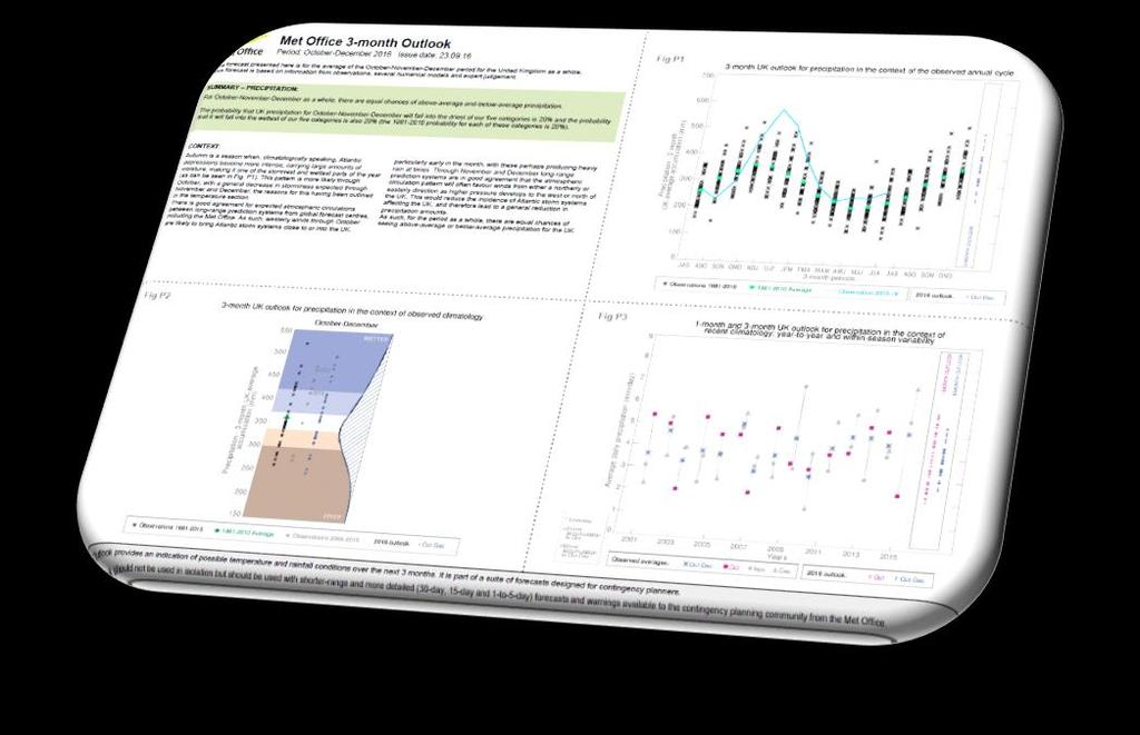
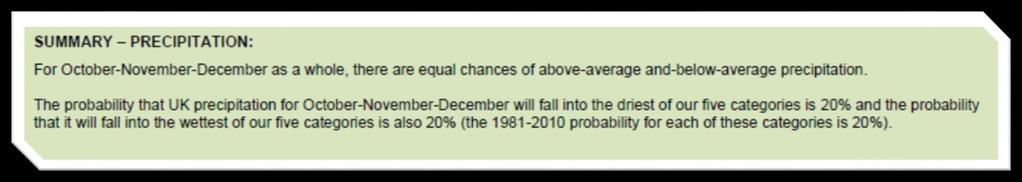
24 Met Office 3 month outlook 24

25 1 month ahead


26 Forecast Products monthly outlook 26

27 6 10 days ahead


28 National Duty Manager Briefing 28


29 FFC Briefing Notes 29


30 Hydromet Guidance 30

31 Out to 5 days ahead


32 Detailed Hydromet Guidance 32
33 Forecast Meteorological Data 33


34 Flood Guidance Statement 34


35 Local Flood Outlook 35


36 Tidal / Heavy Rainfall Alerts 36

37 National Flood Forecasting Duty Officer 37
38
39 Thank you
The UK Flood Forecasting Centre
 Storm Surge Networking Forum, Venice: Tuesday 19 th November 2013 The UK Flood Forecasting Centre Dave Cox - Senior Hydrometeorologist FFC Exeter, England. In My talk today I will cover: Ü Overview of
Flood Risk Forecasts for England and Wales: Production and Communication
 Staines Surrey Flood Risk Forecasts for England and Wales: Production and Communication Jon Millard UEF 2015 : Quantifying and Communicating Uncertainty FFC What is the FFC? Successful partnership between
Using Weather Pattern Analysis to Identify Periods of Heightened Coastal Flood Risk in the Medium to Long Range
 UEF 2017 - Storms Using Weather Pattern Analysis to Identify Periods of Heightened Coastal Flood Risk in the Medium to Long Range David Price (FFC) and Robert Neal (Met Office) Thursday 15 June The Flood
Climate Services in Practice UK Perspective
 Climate Services in Practice UK Perspective Chris Hewitt ICCS, Columbia University, October 2011 Overview Perspectives on: Why have a climate service? What is a climate service? UK activities Examples
LONDON & TE December 2009
 LONDON & TE2100 10 December 2009 Tim Reeder Environment Agency How is London vulnerable to CC? Flooding Overheating Water resources Air Quality Subsidence and heave Wind storms Global climate events What
Coastal Inundation Forecasting Demonstration Project CIFDP. Flood Forecasting Initiative-Advisory Group (FFI-AG 3), Geneva, 5-7 Dec, 2017
, Geneva, 5-7 Dec, 2017") Coastal Inundation Forecasting Demonstration Project CIFDP Flood Forecasting Initiative-Advisory Group (FFI-AG 3), Geneva, 5-7 Dec, 2017 Coastal Flooding & Vulnerable Populations Coastal populations are
Coastal Inundation Forecasting Demonstration Project CIFDP Flood Forecasting Initiative-Advisory Group (FFI-AG 3), Geneva, 5-7 Dec, 2017 Coastal Flooding & Vulnerable Populations Coastal populations are
Application #: TEXT
 TOWN OF FORT MYERS BEACH 2008 PROPOSED COMPREHENSIVE PLAN AMENDMENTS Application #: 2008-13-TEXT Description: Modify the Coastal Management and Future Land Use Elements to reflect the state s new definition
Sea Level Space Watch: Service Offering
 Space for Smarter Government Programme Sea Level Space Watch: Service Offering General Sea Level Space Watch : Operational service developed to support national flood defence planning. Systematically updated
The known requirements for Arctic climate services
 The known requirements for Arctic climate services based on findings described in STT White paper 8/2015 Johanna Ekman / EC PHORS STT Regional drivers The Arctic region is home to almost four million people
Challenges in providing effective flood forecasts and warnings
 Challenges in providing effective flood forecasts and warnings National Centre for Flood Research Inaugural Symposium Justin Robinson Bureau of Meteorology October 2018 Zero Lives Lost A key responsibility
Hydrological forecasting and decision making in Australia
 Hydrological forecasting and decision making in Australia Justin Robinson, Jeff Perkins and Bruce Quig Bureau of Meteorology, Australia The Bureau's Hydrological Forecasting Services Seasonal Forecasts
Job Description. 1) To provide a range of meteorological services, including a forecaster consultancy service.
 To provide a range of meteorological services, including a forecaster consultancy service.") Job Description Job Title: Department: Division: Location: Grade: Responsible to: Trainee Meteorological Forecaster Department of Infrastructure Ports Division Isle of Man Airport Trainee Met Officer Senior
Job Description Job Title: Department: Division: Location: Grade: Responsible to: Trainee Meteorological Forecaster Department of Infrastructure Ports Division Isle of Man Airport Trainee Met Officer Senior
RISC-KIT: EWS-DSS Hotspot Tool
 RISC-KIT: EWS-DSS Hotspot Tool Robert McCall Ap van Dongeren Deltares www.risckit.eu This project has received funding from the European Union s Seventh Programme for Research, Technological Development
Weather Climate Science to Service Partnership South Africa
 PROJECTS UNDERWAY Title of the Weather Climate Science to Service Partnership South Africa Together, building on an existing strong partnership, South African Weather Service and the Met Office will build
Flooding and Climate Change APSE Seminar, 9 February 2017
 Flooding and Climate Change APSE Seminar, 9 February 2017 Local Roads Maintenance 1 Department for Transport OFFICIAL Preparations for Winter Important the transport sector, including local highway authorities,
Improving global coastal inundation forecasting WMO Panel, UR2014, London, 2 July 2014
 Improving global coastal inundation forecasting WMO Panel, UR2014, London, 2 July 2014 Cyclone Sidr, November 2007 Hurricane Katrina, 2005 Prof. Kevin Horsburgh Head of marine physics, UK National Oceanography
NOAA Hurricane Forecast Improvement Project
 NOAA Hurricane Forecast Improvement Project Fred Toepfer Hurricane Forecast Improvement Project Manager November 9 th, 2009 Outline NOAA Hurricane Forecast Improvement Project Driving Issue Purpose NOAA
Presentation Outline. Project Overview. Sea Level Rise Assessment & Decision Tools. Community Engagement. Tina Whitman, Friends of the San Juans
 Healthy Beaches for People & Fish Sea Level Rise Adaptation Tools for San Juan County, WA Tina Whitman & Andrea MacLennan December 10, 2015 Presentation Outline Project Overview Tina Whitman, Friends of
DEVELOPMENT OF A FORECAST EARLY WARNING SYSTEM ethekwini Municipality, Durban, RSA. Clint Chrystal, Natasha Ramdass, Mlondi Hlongwae
 DEVELOPMENT OF A FORECAST EARLY WARNING SYSTEM ethekwini Municipality, Durban, RSA Clint Chrystal, Natasha Ramdass, Mlondi Hlongwae LOCATION DETAILS AND BOUNDARIES ethekwini Municipal Area = 2297 km 2
How advances in atmospheric modelling are used for improved flood forecasting. Dr Michaela Bray Cardiff University
 How advances in atmospheric modelling are used for improved flood forecasting Dr Michaela Bray Cardiff University Overview of current short term rainfall forecasting Advancements and on going research
Sea Level Rise and Coastal Inundation Thursday 11 th October, 2012, 1.00pm, With lunch in the Legislative Council Committee Room
 The Presiding Officers invite Parliamentarians and Staff to a Science Briefing on Sea Level Rise and Coastal Inundation Thursday 11 th October, 2012, 1.00pm, With lunch in the Legislative Council Committee
CLIMATE CHANGE ADAPTATION BY MEANS OF PUBLIC PRIVATE PARTNERSHIP TO ESTABLISH EARLY WARNING SYSTEM
 CLIMATE CHANGE ADAPTATION BY MEANS OF PUBLIC PRIVATE PARTNERSHIP TO ESTABLISH EARLY WARNING SYSTEM By: Dr Mamadou Lamine BAH, National Director Direction Nationale de la Meteorologie (DNM), Guinea President,
Dynamic Coast. Coastal erosion / Management Briefing to THC
 Dynamic Coast Coastal erosion / Management Briefing to THC What is Dynamic Coast? Dynamic Coast is a Scottish Government project, funded by CREW, managed by SNH, with a research team from the University
Planning for coastal hazards in a changing climate
 March 2013 Planning for coastal hazards in a changing climate Catherine Knight, Coastal and Estuary Officer Sharyn French, Manager Land and Natural Environment Presentation overview Stormy past Council
Seamless weather and climate for security planning
 Seamless weather and climate for security planning Kirsty Lewis, Principal Climate Change Consultant, Met Office Hadley Centre 28 June 2010 Global Climate Models Mitigation timescale changes could be avoided
Assessing Sea Level Rise, Storm Surge and Flooding Risks at the Ogunquit Wastewater Treatment Facility COMMITMENT & INTEGRITY DRIVE RESULTS
 Assessing Sea Level Rise, Storm Surge and Flooding Risks at the Ogunquit Wastewater Treatment Facility September 27, 2012 Presentation Outline Reasons for the Study Sea Level Rise, Storm Surge & Flooding
Republic of Mozambique
 Republic of Mozambique Second Expert's Symposium on Multi-Hazard Early Warning Systems with focus on the Role of National Meteorological and Hydrological Services 5-7 May 2009, Toulouse France 1. Background
JCOMM-CHy Coastal Inundation Forecasting Demonstration Project (CIFDP)
") WMO World Meteorological Organization Working together in weather, climate and water JCOMM-CHy Coastal Inundation Forecasting Demonstration Project (CIFDP) Coastal Flooding & Vulnerable Populations Coastal
WMO World Meteorological Organization Working together in weather, climate and water JCOMM-CHy Coastal Inundation Forecasting Demonstration Project (CIFDP) Coastal Flooding & Vulnerable Populations Coastal
Climate Change and the Implications for the Management of Coastal Landslides. James Houghton Senior Geotechnical Engineer Isle of Wight Council
 Climate Change and the Implications for the Management of Coastal Landslides James Houghton Senior Geotechnical Engineer Isle of Wight Council Outline Background to landsliding on the Isle of Wight Current
Global Challenges - Partnering with Service Providers. World Meteorological Organization. J. Lengoasa WMO Deputy Secretary-General
 WMO World Meteorological Organization Working together in weather, climate and water Global Challenges - Partnering with Service Providers J. Lengoasa WMO Deputy Secretary-General jlengoasa@wmo.int http://www.wmo.int/pages/gfcs/gfcs_en.html
Storm Surge/Coastal Inundation State of the Union. Jamie Rhome Storm Surge Team Lead NOAA/National Hurricane Center
 Storm Surge/Coastal Inundation State of the Union Jamie Rhome Storm Surge Team Lead NOAA/National Hurricane Center 2 Tampa: Cat 5 Scenario 3 4 The Stakes are High Combination of SLR and increasing coastal
Key Indicators for Territorial Cohesion & Spatial Planning Stakeholder Workshop - Project Update. 13 th December 2012 San Sebastián, Basque Country
 Key Indicators for Territorial Cohesion & Spatial Planning Stakeholder Workshop - Project Update 13 th December 2012 San Sebastián, Basque Country Key Aims Explore the use of territorial data in developing
NOAA s National Weather Service Philadelphia/Mt. Holly NJ
 Next Briefing Package: Thursday, October 1, 2015 no later than 300 PM Hazards and Impacts: Overview: A dangerous weather pattern is developing for our region. Threats include very heavy rainfall, inland
Sediment management: a european perspective. Piet den Besten Centre for Water Management Rijkswaterstaat, Netherlands
 Sediment management: a european perspective Piet den Besten Centre for Water Management Rijkswaterstaat, Netherlands Content Background of Dutch-German exchange (DGE plus) What is needed for adequate sediment
TOWARDS CLIMATE-RESILIENT COASTAL MANAGEMENT: OPPORTUNITIES FOR IMPROVED ICZM IN BELIZE
 TOWARDS CLIMATE-RESILIENT COASTAL MANAGEMENT: OPPORTUNITIES FOR IMPROVED ICZM IN BELIZE CHANTALLE SAMUELS Coastal Zone Management Authority and Institute The Caribbean Community Climate Change Centre VULNERABILITY
Scotland s centre of expertise for waters. Dynamic Coast - National Coastal Change Assessment: Defence Asset Database
 Scotland s centre of expertise for waters Dynamic Coast - National Coastal Change Assessment: Defence Asset Database Scotland s centre of expertise for waters Published by CREW Scotland s Centre of Expertise
From Climate Science to Climate Services
 Making sense of complexity in an interdependent world: February 2013 From Climate Science to Climate Services Julia Slingo, Met Office Chief Scientist Climate Change: Taking the planet into uncharted territory?
Understanding Weather and Climate Risk. Matthew Perry Sharing an Uncertain World Conference The Geological Society, 13 July 2017
 Understanding Weather and Climate Risk Matthew Perry Sharing an Uncertain World Conference The Geological Society, 13 July 2017 What is risk in a weather and climate context? Hazard: something with the
Michael Cranston, Claire Harley, Lauren McLean, Amy Tavendale, Darroch Kaye, and Lisa Naysmith (Flood Forecasting and Warning section)
") Firths of Forth and Tay Flood Warning System and the Storms of 2012-2014 Keming Hu Acknowledgements Michael Cranston, Claire Harley, Lauren McLean, Amy Tavendale, Darroch Kaye, and Lisa Naysmith (Flood
Firths of Forth and Tay Flood Warning System and the Storms of 2012-2014 Keming Hu Acknowledgements Michael Cranston, Claire Harley, Lauren McLean, Amy Tavendale, Darroch Kaye, and Lisa Naysmith (Flood
Major Hurricane Matthew Briefing Situation Overview
 Major Hurricane Matthew Briefing Situation Overview THIS IS NOW A WORST CASE STORM SURGE SCENARIO Catastrophic Damage is Anticipated for Coastal Areas. Major Hurricane Matthew is still expected to move
Addendum to the Essex and South Suffolk Second Generation Shoreline Management Plan
 Addendum to the Essex and South Suffolk Second Generation Shoreline Management Plan September 2012 CONTENTS 1. Introduction 1 2. Changes in saltmarsh habitat 1 3. Preferred managed realignment policy options
Early Warning > Early Action: The Next Frontier. Dr. Arame Tall Climate Services- Global Coordinator, Champion
 Early Warning > Early Action: The Next Frontier Dr. Arame Tall Climate Services- Global Coordinator, Champion a.tall@cgiar.org 2 3/21/11 The Challenge: Bridging The Gap Seasonal Precipitation Forecast
SLOSH New Orleans Basin 2012 Update
 SLOSH New Orleans Basin 2012 Update Michael Koziara Science and Operations Officer National Weather Service Slidell, LA The Basics What is storm surge? What is SLOSH? Details Assumptions Inundation = Storm
FLOOD-CBA Kassel September 2014
 FLOOD-CBA Kassel September 2014 Oxford Edmund Penning-Rowsell FLOOD-CBA Kassel September 2014 Oxford Techniques, data and tools for CBA in the UK today The Actors The Policies and Guidance Techniques Data
United States Multi-Hazard Early Warning System
 United States Multi-Hazard Early Warning System Saving Lives Through Partnership Lynn Maximuk National Weather Service Director, Central Region Kansas City, Missouri America s s Weather Enterprise: Protecting
Northern Sea Wall, Kent
 Northern Sea Wall, Kent The North Kent Shoreline Management Plan (SMP) defines management units along the North Kent coast ranging from Management Unit 4a - 1A at the Isle of Grain, to Management Unit
Hurricane Matthew Threats and Impacts Briefing for Eastern NC
 Hurricane Matthew Threats and Impacts Briefing for Eastern NC October 6 th, 2016 Date/Time Created: 10/6/2016, Noon EDT National Weather Service Newport/Morehead City, NC Hurricane Matthew Key Points Changes
Rainfall-River Forecasting: Overview of NOAA s Role, Responsibilities, and Services
 Dr. Thomas Graziano Chief Hydrologic Services Division NWS Headquarters Steve Buan Service Coordination Hydrologist NWS North Central River Forecast Center Rainfall-River Forecasting: Overview of NOAA
Seaton to Seaton Hole SUMMARY OF PREFERRED PLAN RECOMMENDATIONS AND JUSTIFICATION
 Location reference: Policy Unit reference: Plan: Seaton to Seaton Hole 6a29 and 6a30 SUMMARY OF PREFERRED PLAN RECOMMENDATIONS AND JUSTIFICATION The large number of properties and assets at risk in the
Communicating Hurricane Threats and Impacts on a National Scale. Daniel Brown Warning Coordination Meteorologist National Hurricane Center
 Communicating Hurricane Threats and Impacts on a National Scale Daniel Brown Warning Coordination Meteorologist National Hurricane Center New NWS Products to Help Communicate Potential Impacts New probabilistic
Ed Curtis, PE, CFM, FEMA Region IX and Darryl Hatheway, CFM, AECOM ASFPM 2016, Grand Rapids, MI
 Methodology to Determine Process-Based Total Water Level Profiles in Areas Dominated by Wave Runup Ed Curtis, PE, CFM, FEMA Region IX and Darryl Hatheway, CFM, AECOM ASFPM 2016, Grand Rapids, MI Thurs.
THE FIRE AND RESCUE SERVICE S ROLE IN RESPONDING TO FLOODING DAVE RUSSEL ASSISTANT CHIEF FIRE OFFICER
 THE FIRE AND RESCUE SERVICE S ROLE IN RESPONDING TO FLOODING DAVE RUSSEL ASSISTANT CHIEF FIRE OFFICER RESPONDING TO FLOODING NATIONAL CONTEXT Fire and Rescue Services Act 2004: Power to respond to floods
The Wind Hazard: Messaging the Wind Threat & Corresponding Potential Impacts
 The Wind Hazard: Messaging the Wind Threat & Corresponding Potential Impacts Scott Spratt Warning Coordination Meteorologist NWS Melbourne, FL David Sharp Science & Operations Officer NWS Melbourne, FL
Seamless water forecasting for Australia
 Seamless water forecasting for Australia Narendra Tuteja, Dasarath Jayasuriya and Jeff Perkins 2 December 2015 Built on extensive research partnerships WIRADA What we do Perspective Situational awareness
EARLY WARNING IN SOUTHERN AFRICA:
 EARLY WARNING IN SOUTHERN AFRICA: Enhancing the Meteorological Early Warning System Eugene Poolman South African Weather Service OUTLINE OF PRESENTATION Impact of Climate Change Meteorological Early Warning
Past & Future Services
 Past & Future Services and Integration with Emergency Responders Graeme Leitch UKMO Public Weather Service The PWS provides a coherent range of weather information and weatherrelated warnings that enable
Urban Integrated Services and Multi-Hazard Early Warning Systems
 WMO for UN New Urban Agenda Urban Integrated Services and Multi-Hazard Early Warning Systems Gregory R. Carmichael WMO WMO Priority: Urbanization - Research and services for megacities and large urban
Probabilistic Coastal Flood Forecasting Nigel Tozer HR Wallingford
 Probabilistic Coastal Flood Forecasting Nigel Tozer HR Wallingford Peter Hawkes, Tim Pullen, HR Wallingford Angela Scott, UKCMF / Environment Agency Jonathan Flowerdew, Ken Mylne, Francois Xavier-Bocquet,
Weather forecasts and warnings: Support for Impact based decision making
 Weather forecasts and warnings: Support for Impact based decision making Gerry Murphy, Met Éireann www.met.ie An Era of Change Climate and weather is changing Societal vulnerability is increasing The nature
Numerical models in context of coastal climate change, adaptation and protection schemes. Nils Drønen Head of Innovation, CED, DHI
 Numerical models in context of coastal climate change, adaptation and protection schemes Nils Drønen Head of Innovation, CED, DHI Agenda Introduction How can we quantify coastal response to climate change
15 March 2010 Re: Draft Native Vegetation of the Sydney Metropolitan Catchment Management Authority Area GIS layers and explanatory reports
 SYDNEY COASTAL COUNCILS GROUP Inc. C/- City of Sydney Council Level 14, 456 Kent Street GPO Box 1591, SYDNEY NSW 2001 Phone: (02) 9246 7791 Facsimile: (02) 9265 9660 Email: info@sydneycoastalcouncils.com.au
MISSOURI LiDAR Stakeholders Meeting
 MISSOURI LiDAR Stakeholders Meeting East-West Gateway June 18, 2010 Tim Haithcoat Missouri GIO Enhanced Elevation Data What s different about it? Business requirements are changing.fast New data collection
Forecasting Flood Risk at the Flood Forecasting Centre, UK. Delft-FEWS User Days David Price
 Forecasting Flood Risk at the Flood Forecasting Centre, UK Delft-FEWS User Days 2012 David Price Overview of the Flood Forecasting Centre (FFC) What is the FFC? Partnership between the Met Office and Environment
Unidata Policy Committee
 Unidata Policy Committee Weather-Ready Nation Saving Lives and Livelihoods May 21, 2014 LeRoy Spayd NOAA/NWS 1 Outline Weather Ready Nation NOAA Budget AWIPS 2 Algorithm Verification study National Water
Improving Sub-Seasonal to Seasonal Prediction at NOAA
 Improving Sub-Seasonal to Seasonal Prediction at NOAA Dr. Louis W. Uccellini Director, National Weather Service NOAA Assistant Administrator for Weather Services July 13, 2016 Congressional Briefing Value
ICE STORM! a mini tabletop exercise for home care agencies
 1 ICE STORM! a mini tabletop exercise for home care agencies HCA Education and Research Winter 2010 2011 2 What is a tabletop exercise? People come together to review and discuss a hypothetical emergency
The UK National Severe Weather Warning Service - Guidance Unit Perspective
 The UK National Severe Weather Warning Service - Guidance Unit Perspective Dan Suri, Chief Operational Meteorologist ECMWF User Workshop June 2015 Contents Who are the Guidance Unit? The National Severe
Extending the use of Flood Modeller Pro towards operational forecasting with Delft-FEWS
 Extending the use of Flood Modeller Pro towards operational forecasting with Delft-FEWS Simone van Schijndel, Department Head Operational Water Management and Early Warning Intentionally blank The world
NOAA s National Weather Service Philadelphia/Mt. Holly NJ
 Next Briefing Package: Friday, October 2, 2015 no later than 300 PM Hazards and Impacts: Overview: A dangerous weather pattern still threatens our region. Threats include very heavy rainfall, inland river
Extreme Weather Events and Transportation Asset Management
 Extreme Weather Events and Transportation Asset Management AASHTO Annual Meeting November 17, 2012 Mike Savonis ICF International 1 AASHTO commissioned a short paper on how to address Extreme Weather Events
L i n k i n g f l o o d i m p a c t f o r e c a s t i n g a n d s a t e l l i t e r a p i d m a p p i n g i n E u r o p e
 L i n k i n g f l o o d i m p a c t f o r e c a s t i n g a n d s a t e l l i t e r a p i d m a p p i n g i n E u r o p e Francesco Dottori, Milan Kalas, Peter Salamon, Annett Wania, Ines Rivero (EC JRC)
Randall W. Parkinson, Ph.D., P.G. Institute of Water and Environment Florida International University
 An Update on Adaptation Action Activities Undertaken Since Completion of the City of Satellite Beach (FL) Vulnerability Assessment to Rising Seas (2010) Randall W. Parkinson, Ph.D., P.G. Institute of Water
Coordinated Safety Messaging: An Integrated Approach. Matt Moreland FLGHC: Effective Messaging and Decision Support Services May 16, 2017
 Coordinated Safety Messaging: An Integrated Approach Matt Moreland FLGHC: Effective Messaging and Decision Support Services May 16, 2017 Question According to most meteorologists, how long should a weather
Sea-level Rise on Cape Cod: How Vulnerable Are We? Rob Thieler U.S. Geological Survey Woods Hole, MA
 Sea-level Rise on Cape Cod: How Vulnerable Are We? Rob Thieler U.S. Geological Survey Woods Hole, MA Outline Sea-level and coastal processes Past sea-level change Predictions for the future Coastal responses
Hurricane Season 2018
 Hurricane Season 2018 Mission Protect LIFE and Property (Save Lives and Livelihoods) NOAA/ National Weather Service We are NOT a 9-to-5 agency. We operate 24/7/365 serving communities. We are available
Wainui Beach Management Strategy (WBMS) Summary of Existing Documents. GNS Tsunami Reports
 Summary of Existing Documents. GNS Tsunami Reports") Wainui Beach Management Strategy (WBMS) Summary of Existing Documents GNS Tsunami Reports a) Review of Tsunami Hazard and Risk in New Zealand ( National Risk Report ) b) Review of New Zealand s Preparedness
Wainui Beach Management Strategy (WBMS) Summary of Existing Documents GNS Tsunami Reports a) Review of Tsunami Hazard and Risk in New Zealand ( National Risk Report ) b) Review of New Zealand s Preparedness
Natura 2000 in the marine environment: state of implementation and next steps
 Life on the blue planet: biodiversity research and the new European marine policies EPBRS European Platform on Biodiversity Research Strategy Porto, Portugal 7-9 November 2007 Natura 2000 in the marine
Coastal Inundation Forecasting and Community Response in Bangladesh
 WMO Coastal Inundation Forecasting and Community Response in Bangladesh Bapon (SHM) Fakhruddin Nadao Kohno 12 November 2015 System Design for Coastal Inundation Forecasting CIFDP-PSG-5, 14-16 May 2014,
Weather Forecasting in Flood Forecasting Activities
 Weather Forecasting in Flood Forecasting Activities Eugene Poolman South African Weather Service Representing CBS Pretoria South Africa FCAST PRES 20130919 001 Main Activities of CBS Development, implementation
THE FLOODRESILIENCITY PROJECT
 THE FLOODRESILIENCITY PROJECT Tony Maguire, Senior Executive Engineer, Environment & Engineering Department, Dublin City Council. EWA SYMPOSIUM IFAT 2010 Note all photos & graphics FRC Project; Dublin
VISIT MISSISSIPPI GULF COAST CRISIS COMMUNICATION MANUAL 2016
 VISIT MISSISSIPPI GULF COAST CRISIS COMMUNICATION MANUAL 2016 This manual was prepared for Visit Mississippi Gulf Coast staff in the event of a crisis, and will help to distinguish the appropriate course
StormReady Supporter Application Form updated by NWS Chanhassen on April 7, Name of Applying Entity: Point of Contact: Title:
 NATIONAL WEATHER SERVICE 1733 Lake Drive West Chanhassen, Minnesota www.weather.gov/twincities www.stormready.noaa.gov 952-361-6671, todd.krause@noaa.gov StormReady Supporter Application Form updated by
Mermaid. The most sophisticated marine operations planning software available.
 Mermaid The most sophisticated marine operations planning software available. Mojo Maritime / Marine economic risk management aid Mermaid : marine economic risk management aid The most sophisticated marine
Natural Susceptibility to Coastal Erosion: Methodology and Mapping Summary
 Natural Susceptibility to Coastal Erosion: Methodology and Mapping Summary. Introduction The Flood Risk Management (Scotland) Act 2009 (FRM Act) introduced a coordinated and partnership approach to how
Unit 4. This unit will enable you to improve coordination and communication with State and local agencies when hazardous weather threatens.
 Unit 4 This unit will enable you to improve coordination and communication with State and local agencies when hazardous weather threatens. In this unit we will discuss the role of Emergency Managers in
A Detailed First Pass coastal hazard assessment for a long complex coast: Kingborough LGA, Tasmania
 A Detailed First Pass coastal hazard assessment for a long complex coast: Kingborough LGA, Tasmania Chris Sharples & Paul Donaldson University of Tasmania September 2012 Kingborough LGA, south-eastern
Bistandsprosjekter i Sørøst-Asia
 Bistandsprosjekter i Sørøst-Asia -Sikre liv og verdier Lars R. Hole, Hanneke Luijting, Tor Ivar Mathisen og Kristine Gjesdal September 2017 Norwegian Meteorological Institute Background Ministry of Foreign
An overview of the applications for early warning and mapping of the flood events in New Brunswick
 Flood Recovery, Innovation and Reponse IV 239 An overview of the applications for early warning and mapping of the flood events in New Brunswick D. Mioc 1, E. McGillivray 2, F. Anton 1, M. Mezouaghi 2,
New Zealand s Next Top Model: integrating tsunami modelling into land use planning
 New Zealand s Next Top Model: integrating tsunami modelling into land use planning Wendy Saunders (MZNZPI), Gegar Prasetya, Graham Leonard GNS Science, Lower Hutt, w.saunders@gns.cri.nz In April 2011 a
Delivering Met to the Military User
 Delivering Met to the Military User Andy Kirkman Met Office Defence Business Manager ECMWF MOS Workshop - November 2007 Crown copyright 2006 Page 1 Delivering Met to the Military User This Presentation
Implementation of the ESPON 2020 cooperation program. 16 January 2017 Anneloes van Noordt
 Implementation of the ESPON 2020 cooperation program 16 January 2017 Anneloes van Noordt Outline! ESPON Cooperation Program! Specific Objectives! Applied Research! Targeted Analysis! Database & Tools!
Daily Operations Briefing. Saturday, March 3, :30 a.m. EST
 Daily Operations Briefing Saturday, March 3, 2018 8:30 a.m. EST Northeast Coastal Storm Situation A high-impact and long duration coastal storm is bringing area of heavy rain and snow, significant coastal
President s Day Weekend Storm Community Meeting and Workshop April 17, 2017
 President s Day Weekend Storm Community Meeting and Workshop April 17, 2017 Meeting outline 1. Progress update on the City of San Jose s recovery efforts 2. Water district presentation on: Weather situation
County Clare Flood Forecasting System
 County Clare Flood Forecasting System Paul Moroney BE (Civil), C. Eng. M.I.E.I. M.C.I.Arb. Head of the Environment Section Clare County Council (The views expressed in this paper represent the professional
Physical landscapes River landscapes in the UK
 Physical landscapes River landscapes in the UK The shape of river valleys change s as rivers flow downstream - PROCESSES Erosion Abrasion or corrasion Attrition Hydraulic Action Solution or corrosion Deposition
Regional-scale understanding of the geologic character and sand resources of the Atlantic inner continental shelf, Maine to Virginia
 Regional-scale understanding of the geologic character and sand resources of the Atlantic inner continental shelf, Maine to Virginia Workshop on Dredging, Beach Nourishment and Bird Conservation Atlantic
Rivers Trusts and NIEA Working in partnership
 Rivers Trusts and NIEA Working in partnership Lakes Symposium 5 th October 2012 Stormont Mark Horton BSc(Hons) MSc Northern Ireland Development Officer What are Rivers Trusts? Charities established to
Daily Operations Briefing. Sunday, March 4, :30 a.m. EST
 Daily Operations Briefing Sunday, March 4, 2018 8:30 a.m. EST Significant Activity Mar 3-4 Significant Events: Northeast coastal storm Tropical Activity: Western Pacific No activity affecting U.S. interests
Table-Top Exercise for Emergency Preparedness Evaluation: Little Anse, Isle Madame
 Table-Top Exercise for Emergency Preparedness Evaluation: Little Anse, Isle Madame Alexander Chung, M.Sc. Candidate C-Change Student Research Associate May 2013 The Community of Little Anse Coastal community
BUREAU OF METEOROLOGY
 BUREAU OF METEOROLOGY Building an Operational National Seasonal Streamflow Forecasting Service for Australia progress to-date and future plans Dr Narendra Kumar Tuteja Manager Extended Hydrological Prediction