INTEGRATED COASTAL SEDIMENT MANAGEMENT AT PHYSIOGRAPHIC UNIT SCALE, AN APPLICATION IN VERSILIA LITTORAL (TUSCANY, ITALY)
|
|
|
- Theresa Floyd
- 6 years ago
- Views:
Transcription


")
")
1 INTEGRATED COASTAL SEDIMENT MANAGEMENT AT PHYSIOGRAPHIC UNIT SCALE, AN APPLICATION IN VERSILIA LITTORAL (TUSCANY, ITALY) Damiano Scarcella (Msc) Sergio Cappucci (PhD) Andrea Taramelli (PhD)
2 OUTLINE Sediment management role in ICZM Need for a decision support system tool Principal features of the Sediment Management Decision Support System (SMDSS) Sediment management and policy making in port dredging: Marina di Carrara Data input and some expected output from SMDSS on Apuo- Versilian coastal cell Conclusions
 Funding Planning and design Cost / Benefits Public Private Partnership and Project Financing Integrated approach and best")
3 COASTAL EROSION: A BROAD VISION Ports Rivers Bruntland - WCED (1987) Beaches Sandpits 1150 Km of sandy coast at Risk for erosion in Italy (ISPRA 2010) Funding Planning and design Cost / Benefits Public Private Partnership and Project Financing Integrated approach and best practice
4 Sediment Management Ports Rivers Beaches Sandpits Infrastructures and Mobility, coastal settlements Agricolture and Irrigation Habitat and landscape preservation Tourism Energy Harbours activities, navigation Pollution, water resources, environmental monitoring Fisheries and acquaculture
5 ICZM IN EUROPE May 2002 EU Recommendation for actuation of ICZM in Europe June 2006-Ottobre 2007, publication of green and blue Books of EU on Integrated marine policy (ICZM and use of the sea) January 2008 (Madrid), VII Protocol of Barcellona Convention on ICZM in the Mediterranean Sea September 2010: EU Adoption of the ICZM protocol April 2011: EU Commission public consultation on possible EU action on ICZM

, VII Protocol of Barcellona Convention on ICZM in the")
6 ICZM IN EUROPE May 2002 EU Recommendation for actuation of ICZM in Europe June 2006-Ottobre 2007, publication of green and blue Books of EU on Integrated marine policy (ICZM and use of the sea) January 2008 (Madrid), VII Protocol of Barcellona Convention on ICZM in the Mediterranean Sea
7 PLANNING INTRUMENTS AND DIRECTIVES INVOLVING SEDIMENTS EU ICZM procol Water framework directive Marine strategy framework directive Local Planning instruments Harbour masterplans Municipalities masterplans River basin masterplan for hydrogeologic risk (PAI) italian D.L. 180/98 Reservoir management plan italian Law 152/99 Regional ICZM planning


8 NEED FOR A DECISIONS SUPPORT SYSTEM INTEGRATED SYSTEM TO MANAGE PROCEDURES LINKED TO GEOGRAPHICAL FEATURES GIS PEOPLE Regions Provinces Municipalities Port Authorites Reservoir owners National research institutes Dredging companies RESOURCES Sediments! WORK FLOW MANAGEMENT ACTIONS Port dredging Beach nourishment Hard coastal defence Marinas construction Reservoir management Offshore sandpit dredging Land reclamation Creation of sand trap River dredging Adapted from Globo, 2008


 DATA PROCESSES PROCEDURES COST BENEFIT ANALYSIS DECISIONS")
9 FEATURES OF A SM DECISIONS SUPPORT SYSTEM COMPOUND DSS (database + rules) 1. Inputs: Factors, numbers, and features to analyze 2. Users Knowledge and Expertise: Inputs requiring manual analysis by multiple users 3. Outputs: Transformed data from which DSS "decisions" are generated 4. Decisions: Results generated by the DSS based on user criteria (cost-benefit, life saving ) DATA PROCESSES PROCEDURES COST BENEFIT ANALYSIS DECISIONS COMMUNICATION Adapted from Globo, 2008

10 COST / BENEFIT ANALYSIS FOR BEACH NOURISHMENT From Lupino, 2006
 Transportation cost for sediment (USACE RSM, 2004) SOME BENEFITS Recreational value for beaches Local Interviews Travel cost")
11 COST / BENEFIT ANALYSIS FOR BEACH NOURISHMENT SOME COSTS Nourishment vs. hard structures Hard defence: 4.5M / Km Soft defence: 4 M / Km (Italian Ministry of Environment, 2006) Transportation cost for sediment (USACE RSM, 2004) SOME BENEFITS Recreational value for beaches Local Interviews Travel cost method Tax Revenues (Italy: State Regions?) /m 2 (Nomisma, 2005) Rapporto investimento - ritorno economico globale -- base rapporto : 1 investito ripascimento 1 ANNO 3 ANNO 5 ANNO Elaborated from Nomisma, 2005
12 CASE STUDY: INPUT FOR A SMDSS: APUO-VERSILIAN COASTS INPUTS: Factors, numbers, and feature to analyze Where What Harbours Beaches Resorvoirs Sand pits Capital dredging and maintenance of coastal structures Siltation rate (m 3 /y) of ports Long shore transport Water and sediment discharge of rivers Reservoir s storage capacity Periodic bathymetric and coastline surveys Sea bed mapping and classification Search and characterization of off shore sand deposits Pollutant contents for emerged-beaches and seabed sediments Possible sandtrap locations


13 DREDGING AND DISPOSAL OPERATIONS AT MARINA DI CARRARA Sedimentological evidence of infill process Time history of dredge and fill operations Contamination level Sediment management Influence on sediment budget

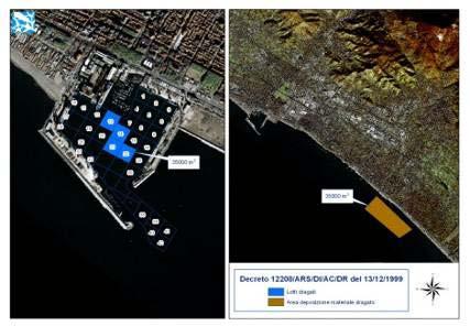
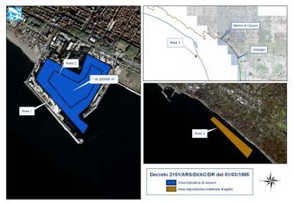
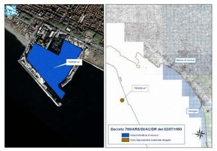
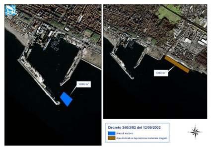
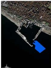
14 DREDGING AND DISPOSAL OPERATIONS AT MARINA DI CARRARA Contaminated Site of National Interest Dredging Disposal
 were carried out at the harbor inlet, suggesting an average filling of about 10.000 m 3 /y.")
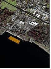
15 DREDGING AND DISPOSAL OPERATIONS AT MARINA DI CARRARA Dredged volumes authorized by MATTM with 10 decrees (2 authorized by local administrations in 2000 and 2006) The last 4 interventions (out of 12) were carried out at the harbor inlet, suggesting an average filling of about m 3 /y. The 2007 nourishment was imposed for compensation
16 DREDGING AND DISPOSAL OPERATIONS AT MARINA DI CARRARA Dumping 305,000 m 3 Dredged volume 849,500 m 3 Sediment output 530,000 m 3 CDF 215,000 m 3 Landfill 10,000 m 3 Sediment Transfer 319,500 m 3 Nourishment 344,500 m 3 Sediment Input 25,000 m 3
17 DREDGING AND DISPOSAL OPERATIONS AT MARINA DI CARRARA sediment deficit dredged material nourishment m year The sediment deficit mainly caused by the recent dredging of the harbor inlet to a depth of 10 m and delivery of the sediment to a CDF. After 2000 the small dredging has been almost compensated by downdrift nourishment. The compensation strategy was imposed only in 2007.

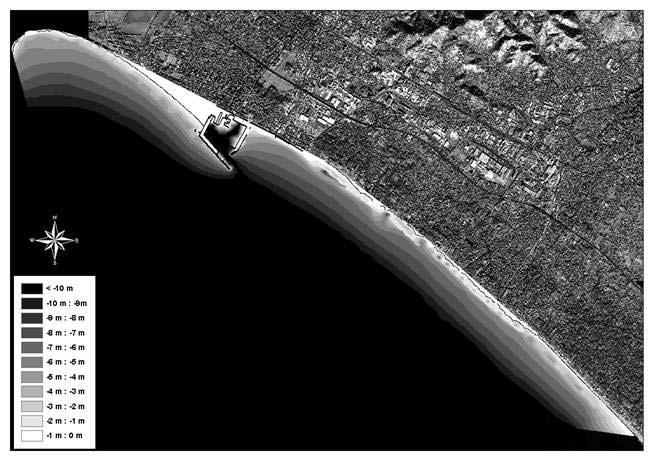
18 APUO-VERSILIAN COAST CELL (north) Length: 50 km (between Magra River and Livorno) A S.I.N. was established in 1999 River Magra dredging for navigation SIN Coastal erosion Marina di Carrara harbour was built in 1924 is and Viareggio in They both suffer periodical infill. Carrara Harbour dredging Littoral drift convergence River Magra also needs dredging for navigation Viareggio Harbour dredging
 From Deltares,")
19 APUO-VERSILIAN COAST CELL: RIVER SOLID TRANSPORT Magra: m 3 /y (Cappucci et al, 2008) From Deltares, 2006


20 APUO-VERSILIAN COAST CELL: BEACH PROFILES Sedimentological surveys on 393 transects (Regione Toscana) Offshore bar Submerged breakwater From Deltares, 2006

21 APUO-VERSILIAN COAST CELL: RESERVOIRS RESERVOIRS: Magra: 2 Serchio: 14 Arno: 19
22 NOURISHMENT PLANNING / LONG TERM EROSION Alert given by processing of periodical survey data Decision on nourishment (from modeling and Cost Benefit analysis) YES NO Standard monitoring DSS Database update Nourishment project (design: at least 200 m3/ml; monitoring&maintanance) Decision on Borrow area Priority list: 1. Port dredging 2. Other downdrift stocks 3. Offshore sandpits Nourishment
23 CONCLUSIONS ICZM ask for an Integrated Sediment Management A DSS approach for sediment management (SMDSS) can help to better design any intervention and to obtain better cost/benefit performances Different users (responsible administrations) need the same DSS in order to keep the management integrated The SMDSS can be a compund DSS structured with database and rules that can come from numerical modeling DSSSM structure can be modular in order to better allow the deepening of any ring of the chain Input data for a prototype of SMDSS on the Apuo Versilian coast has been showed. The data must be shared, the action must be coordinated

24 THANK YOU FOR THE ATTENTION! www. isprambiente.it
Heather Schlosser Army Corps of Engineers Coastal Studies Group August 28, 2008
 Got sand? Regional Sediment Management in Orange County Heather Schlosser Army Corps of Engineers Coastal Studies Group August 28, 2008 Regional Sediment Management Regional sediment management recognizes
A new tool for littorals management support in Emilia-Romagna
 Direzione Generale Ambiente, Difesa del Suolo e della Costa Regional action strategies for coastal zone adaptation to climate change A new tool for littorals management support in Emilia-Romagna the Littoral
Margarita Stancheva Hristo Stanchev & Robert Young 2. MEDCOAST JUBILEE WORKSHOP May 2015, Iberotel Sarigerme Park, Dalaman, Turkey
 Margarita Stancheva Hristo Stanchev & Robert Young 2 INTRODUCTION: Bulgarian Black Sea coast INTRODUCTION: Increasing pressure on Bulgarian coastal zone In 2011, of the 7 364 570 people that lived in Bulgaria,
Newsletter # 2. Pilot sites in Greece. December 2018
 A HarmonizEd framework to Mitigate coastal EroSion promoting ICZM protocol implementation Newsletter # 2 December 2018 View of a beach in Ammolofi ( Paggaio Municipality ) Pilot sites in Greece 1. Name
HELSINKI COMMISSION Baltic Marine Environment Protection Commission
 HELSINKI COMMISSION Baltic Marine Environment Protection Commission HELCOM RECOMMENDATION 24/10 Adopted 25 June 2003, having regard to Article 20, Paragraph 1 b) of the 1992 Helsinki Convention IMPLEMENTATION
Coastal Mapping Follow on? Bruno Frachon Corine Lochet Gaël Morvan
 Coastal Mapping Follow on? Bruno Frachon Corine Lochet Gaël Morvan Shared objectives; IHO DG MARE CPMR Development of a Joint European Coastal Mapping Programme (JECMaP) within the IHO EU network with
Country reports. Israel did not establish an Exclusive Economic Zone. Consequently, its jurisdiction is restricted to the Israeli territorial waters.
 Country reports I. ISRAEL Disclaimer This document has not been adopted by the European Commission and should therefore not be relied upon as a statement of the European Commission. The purpose of this
ISPRA. Stefano Bataloni ISPRA
 MINISTRY FOR THE ENVIRONMENT AND LAND AND SEA PROTECTION Istituto Superiore per la Protezione e la Ricerca Ambientale National Institute for Environmental Protection and Research THE ITALIAN NATIONAL BOARD
Shoreline Evolution and Protection StrategiesAlong the Tuscany Coastline, Italy
 Journal of Coastal Research SI 9 84-847 ICS 4 (Proceedings) Brazil ISSN 749-8 Shoreline Evolution and Protection StrategiesAlong the Tuscany Coastline, Italy E. Pranzini and E.J. Farrell Dipartimento di
SHORELINE AND BEACH PROCESSES: PART 2. Implications for Coastal Engineering
 SHORELINE AND BEACH PROCESSES: PART 2 Implications for Coastal Engineering Objectives of the lecture: Part 2 Show examples of coastal engineering Discuss the practical difficulties of ocean engineering
SEGMENTED BREAKWATERS AND THEIR USE IN COASTAL LOUISIANA
 SEGMENTED BREAKWATERS AND THEIR USE IN COASTAL LOUISIANA Prepared by: Louisiana Coastal Protection and Restoration Authority Engineering Division March 2016 The geology of Louisiana s coastal zone is intimately
Planning for the Future of Humboldt Bay: Sea Level Rise, Sediment Management, Sand Spits and Salt Marshes. Joel Gerwein
 Planning for the Future of Humboldt Bay: Sea Level Rise, Sediment Management, Sand Spits and Salt Marshes Joel Gerwein Introduction to Humboldt Bay Setting Economy, community, and environment Sediment
Port of Kalama, 2013 TEMCO Berth Maintenance Dredging and In-water Flow-Lane Placement Project
 2014 WEDA ENVIRONMENTAL EXCELLENCE AWARDS Category: Navigation Dredging Port of Kalama, 2013 TEMCO Berth Maintenance Dredging and In-water Flow-Lane Placement Project Port of Kalama, Washington 18 April
Graduate School of Civil and Ecological Engineering, I-Shou University, Kaohsiung, Taiwan, R.O.C.
 Journal of Civil Engineering and Architecture 10 (2016) 1297-1303 doi: 10.17265/1934-7359/2016.11.011 D DAVID PUBLISHING Ho-Shong Hou Graduate School of Civil and Ecological Engineering, I-Shou University,
Issue to be addressed
 Climate change impacts in fluvial, coastal and transition zones in Mediterranean environments altered by human activities: Guadalfeo and Adra river mouths Andrea Lira Loarca - aliraloarca@ugr.es Manuel
Connecticut Coastal Management Program
 Connecticut Coastal Management Program Fact Sheet for SHORELINE FLOOD AND EROSION CONTROL STRUCTURES What are Shoreline Flood and Erosion Control Structures? The Connecticut General Statutes (CGS) define
BEFORE THE ENVIRONMENTAL PROTECTION AUTHORITY AT WELLINGTON
 BEFORE THE ENVIRONMENTAL PROTECTION AUTHORITY AT WELLINGTON IN THE MATTER of the Exclusive Economic Zone and Continental Shelf (Environmental Effects) Act 2012 (EEZ Act) AND IN THE MATTER BETWEEN AND AND
Dynamic preservation of the coastline
 Dynamic preservation of the coastline Content Introduction The Dutch coastal defence by dynamic processes Data collection Management of the sand resources Growing importance of marine sand and gravel resources
Environmental impact assessment study of the new offshore dumping sites for Šventoji port in Lithuania
 Environmental impact assessment study of the new offshore dumping sites for Šventoji port in Lithuania Introduction Summary In 2003 Lithuanian Ministry of Transport initiated the preparation of feasibility
TOWARDS CLIMATE-RESILIENT COASTAL MANAGEMENT: OPPORTUNITIES FOR IMPROVED ICZM IN BELIZE
 TOWARDS CLIMATE-RESILIENT COASTAL MANAGEMENT: OPPORTUNITIES FOR IMPROVED ICZM IN BELIZE CHANTALLE SAMUELS Coastal Zone Management Authority and Institute The Caribbean Community Climate Change Centre VULNERABILITY
Introduction to EMODnet
 Introduction to EMODnet Antonio Novellino Torino, 14-15 Ottobre 2015 What is EMODnet? Initiated by the European Commission in response to the EU Future Maritime Policy and Blue Growth, launched in June
MyCoast Elaboration of a vision and a strategy for Integrated Coastal Zone Management in Bulgaria
 1. NAME MyCoast Elaboration of a vision and a strategy for Integrated Coastal Zone Management in Bulgaria 2. DESCRIPTION 2.1 The case Bulgaria s coastal territory is distributed among three administrative
Regional Sediment Management
 Regional Sediment Management Linda S. Lillycrop Program Manager Coastal Engineer US Army Engineer Research and Development Center Coastal and Hydraulics Laboratory Q AVG Coastal Resilience: The Environmental,
Natura 2000 in the marine environment: state of implementation and next steps
 Life on the blue planet: biodiversity research and the new European marine policies EPBRS European Platform on Biodiversity Research Strategy Porto, Portugal 7-9 November 2007 Natura 2000 in the marine
Cliff stabilisation. Adaptation Option Climate-ADAPT
 Cliff stabilisation Adaptation Option Climate-ADAPT Cover design: EEA Cover photo: EEA Layout: EEA Legal notice The contents of this publication do not necessarily reflect the official opinions of the
Evaluation Model for the Sustainable Development of European Coastal Zones
 Evaluation Model for the Sustainable Development of European Coastal Zones SUMMARY Interreg IIIC - South 2 INDEX 1.- INTRODUCTION... 3 2.- CONTEXT OF DEDUCE... 4 3.- CURRENT SITUATION AND CHALLENGES...
4 Project Alternatives
 BSD Deepening EIR Page 50 4 Project Alternatives In terms of the EIA regulations (Regulation 6 (1) (d) GN No. R1183, dated 5 September 1997) and NEMA, the applicant is required to demonstrate that alternatives
The Great Lakes Coalition is an organization of shoreline property owners on the Great Lakes dedicated to improving the quality of life for both it s
 The Great Lakes Coalition is an organization of shoreline property owners on the Great Lakes dedicated to improving the quality of life for both it s s membership and the public at large. Facts about Section
Prediction of changes in tidal system and deltas at Nakdong estuary due to construction of Busan new port
 Prediction of changes in tidal system and deltas at Nakdong estuary due to construction of Busan new port H. Gm1 & G.-Y. park2 l Department of Civil & Environmental Engineering, Kookmin University, Korea
Sediment management: a european perspective. Piet den Besten Centre for Water Management Rijkswaterstaat, Netherlands
 Sediment management: a european perspective Piet den Besten Centre for Water Management Rijkswaterstaat, Netherlands Content Background of Dutch-German exchange (DGE plus) What is needed for adequate sediment
Marine Spatial Data for Marine Spatial Planning. Ocean Leadership 2010 Public Policy Forum
 Marine Spatial Data for Marine Spatial Planning Ocean Leadership 2010 Public Policy Forum March 10, 2010 Edward Saade President, Fugro EarthData, Inc 1 Marine Spatial Data What is Marine Spatial Data?
The Urban Sea and Coastal Zone Management
 The Urban Sea and Coastal Zone Management David NEALE, Trinidad and Tobago Key words: hydrography, Caribbean, coastal zone management, land use. SUMMARY Within the coastal zone of Eastern Caribbean States,
Regional Sediment Management: The Long Island Coastal Planning Project
 Regional Sediment Management: The Long Island Coastal Planning Project Lynn M. Bocamazo Senior Coastal Engineer USACE-New York District 22 September 2009 US Army Corps of Engineers Outline Project Location
Regional-scale understanding of the geologic character and sand resources of the Atlantic inner continental shelf, Maine to Virginia
 Regional-scale understanding of the geologic character and sand resources of the Atlantic inner continental shelf, Maine to Virginia Workshop on Dredging, Beach Nourishment and Bird Conservation Atlantic
SPLAN-Natura Towards an integrated spatial planning approach for Natura th January, 2017 Brussels. Commissioned by DG Environment
 SPLAN-Natura 2000 Towards an integrated spatial planning approach for Natura 2000 Commissioned by DG Environment 17 th January, 2017 Brussels V. Simeonova (Ph.D.) Drivers towards integrating Biodiversity
R E P U B L I C O F C Y P R U S NATIONAL REPORT OF CYPRUS TO THE MEDITERRANEAN AND BLACK SEAS HYDROGRAPHIC COMMISSION (MBSHC)
") R E P U B L I C O F C Y P R U S NATIONAL REPORT OF CYPRUS TO THE MEDITERRANEAN AND BLACK SEAS HYDROGRAPHIC COMMISSION (MBSHC) ISTANBUL MEETING 25-27 SEPTEMBER 2013 NATIONAL REPORT OF CYPRUS TO THE MEDITERRANEAN
R E P U B L I C O F C Y P R U S NATIONAL REPORT OF CYPRUS TO THE MEDITERRANEAN AND BLACK SEAS HYDROGRAPHIC COMMISSION (MBSHC) ISTANBUL MEETING 25-27 SEPTEMBER 2013 NATIONAL REPORT OF CYPRUS TO THE MEDITERRANEAN
Del Mar Sediment Management Study
 Del Mar Sediment Management Study Shoreline Preservation Working Group, June 7, 2018 Lindsey Sheehan Current work in Del Mar 2016 Sea-Level Rise Vulnerability Assessment 2018 Adaptation Plan 2018 Sediment
MR. George ALEXAKIS, parallel session 3. "Mediterranean Sea Region. laying the conditions. for sustainable growth and jobs"
 parallel session 3 "Mediterranean Sea Region laying the conditions for sustainable growth and jobs" MR. George ALEXAKIS, elected Regional Councillor of Crete, Greece and representative of Crete in CRPM.
I. LIBYA I.1. COUNTRY CHARACTERISTICS. Country reports
 Country reports I. LIBYA Disclaimer This document has not been adopted by the European Commission and should therefore not be relied upon as a statement of the European Commission. The purpose of this
GALVESTON BAY RSM Moving toward an Integrated, Cooperative, and Holistic Approach to Estuarine Sediments
 GALVESTON BAY RSM Moving toward an Integrated, Cooperative, and Holistic Approach to Estuarine Sediments RAE Conference 2010 Larry A. Wise Moffatt & Nichol RSM is a system-based approach for collaboratively
Mapping Water Resources and Reservoirs for Climate Resilience in Zambezi River Basin
 Mapping Water Resources and Reservoirs for Climate Resilience in Zambezi River Basin Corné van der Sande, NEO BV Senior Advisor Earth Observation Services for Monitoring Drought and Water Resources in
Coastal dune consideration for erosion and marine submersion characterization along the Aquitaine coast (SW France)
") Coastal dune consideration for erosion and marine submersion characterization along the Aquitaine coast (SW France) Integrated Coastal Dune Management in Europe Case studies EUCC Merlimont, 17-19 June
Coastal dune consideration for erosion and marine submersion characterization along the Aquitaine coast (SW France) Integrated Coastal Dune Management in Europe Case studies EUCC Merlimont, 17-19 June
Engineering with Nature: Nearshore Berm Placements at Fort Myers Beach and Perdido Key, Florida, USA
 Engineering with Nature: Nearshore Berm Placements at Fort Myers Beach and Perdido Key, Florida, USA Katherine E. Brutsché, Ph.D. Research Physical Scientist ERDC-Coastal & Hydraulics Laboratory May 14,
INDICATORS FOR INTEGRATED COASTAL ZONE MANAGEMENT (ICZM)
") IOC UNESCO / Leader Task 4.1 Contact Francesca Santoro, Julian Barbiere E-mail: f.santoro@unesco.org, j.barbiere@unesco.org Phone: +33 1 45683952 How to cite this factsheet: PEGASO Consortium. 2013. Area
IOC UNESCO / Leader Task 4.1 Contact Francesca Santoro, Julian Barbiere E-mail: f.santoro@unesco.org, j.barbiere@unesco.org Phone: +33 1 45683952 How to cite this factsheet: PEGASO Consortium. 2013. Area
Oman NSDI Business Values and Future Directions. Hassan Alawi Alghazali Acting Director General National Spatial Data Infrastructure
 Oman NSDI Business Values and Future Directions Hassan Alawi Alghazali Acting Director General National Spatial Data Infrastructure Presentation Outline Geospatial Maturity Current Challenges NCSI s Role
Seabed knowledge In support of UN SDGs
 Seabed knowledge In support of UN SDGs Evert Flier Fiskerifaglig forum 2. november 2017 Hydrography & small scale fishing Hydrography in Transition Serving the Maritime Community Hydrography in Transition
E x a m p l e s o f t o o l s f o r s e a s i t u a t i o n a l a w a r e n e s s u s i n g C M E M S d a t a. Copernicus EU
 E x a m p l e s o f t o o l s f o r s e a s i t u a t i o n a l a w a r e n e s s u s i n g C M E M S d a t a Copernicus EU Copernicus EU Copernicus EU www.copernicus.eu S e a S i t u a t i o n a l A w
EUROSION: Coastal erosion measures, knowledge and results acquired through 60 studies
 Herrier J.-L., J. Mees, A. Salman, J. Seys, H. Van Nieuwenhuyse and I. Dobbelaere (Eds). 2005. p. 421-431 Proceedings Dunes and Estuaries 2005 International Conference on Nature Restoration Practices in
EO Information Services. Assessing Vulnerability in the metropolitan area of Rio de Janeiro (Floods & Landslides) Project
 Project") EO Information Services in support of Assessing Vulnerability in the metropolitan area of Rio de Janeiro (Floods & Landslides) Project Ricardo Armas, Critical Software SA Haris Kontoes, ISARS NOA World
EO Information Services in support of Assessing Vulnerability in the metropolitan area of Rio de Janeiro (Floods & Landslides) Project Ricardo Armas, Critical Software SA Haris Kontoes, ISARS NOA World
GIS-Based Sediment Quality Database for the St. Louis River Area of Concern (AOC): Overview Presentations and Demonstration
: Overview Presentations and Demonstration") GIS-Based Sediment Quality Database for the St. Louis River Area of Concern (AOC): Overview Presentations and Demonstration Judy L. Crane 1 and Dawn E. Smorong 2 1 Minnesota Pollution Control Agency, St.
GIS-Based Sediment Quality Database for the St. Louis River Area of Concern (AOC): Overview Presentations and Demonstration Judy L. Crane 1 and Dawn E. Smorong 2 1 Minnesota Pollution Control Agency, St.
Dredging and environment : MARCOM contributions
 Dredging and environment : MARCOM contributions by Mr Geoffroy CAUDE Chairman of MARCOM General Delegate of Union des ports de France (french ports association) Dredging and environment : MARCOM contributions
16540/14 EE/cm 1 DG E 1A
 Council of the European Union Brussels, 5 December 2014 (OR. en) 16540/14 ENV 965 CULT 139 NOTE From: To: Subject: General Secretariat of the Council Delegations Charter of Rome on Natural and Cultural
ICZM and Coastal Monitoring Systems. The experience gained from BeachMed-e
 Observing System Requirements for Managing and Mitigating the Impacts of Human Activities and Coastal Inundation in the Mediterranean Region June 9-13, 2008, Athens, Greece BEACHMED e INTERREG IIIC Sud
Coastal Engineering Survey Services
 Coastal Engineering Survey Services Engineering The Coastline We have created world-class ports and sustainable coastal environments, sculpting shorelines and enhancing land values. Our reclamation work
Croatian physical planning system and strategic approach to MSP
 W 1/7 Past two years all over the Europe: case studies 2 Croatian physical planning system and strategic approach to MSP Vesna Marohnić Kuzmanović Head of Department Croatian Institute for Spatial Development
Climate change and socio-economic impact on the long term sediment balance in the Belgian Part of the North Sea
 Climate change and socio-economic impact on the long term sediment balance in the Belgian Part of the North Sea De Sutter Renaat, Ghent University & IMDC Van Lancker Vera, Fettweis Michael, Van den Eynde
2. Defining fisheries areas
 What does fisheries area mean in the context of the EFF? Axis 4 of the European Fisheries Fund (EFF) is different from the other three Axes in that it targets fisheries areas (it is titled Sustainable
AS & A2 Geography for OCR. Tailored Courses. Slapton Ley
 AS & A2 Geography for OCR Tailored Courses Slapton Ley Please visit http://www.field-studies-council.org/outdoorclassroom/geography/aqa/ for alternative A-level AQA programmes OVERVIEW Since the assessment
Erosion along the Holderness Coast
 PT-2013: Coastal and Ocean Engineering ENGI.8751 Undergraduate Student Forum Faculty of Engineering and Applied Science, Memorial University, St. John s, NL, Canada March, 2013 Paper Code. (PT-2013 - Carson)
Flood Risk Mapping and Forecasting in England
 Flood Risk Mapping and Forecasting in England Mark Franklin Environment Agency, England NORDESS Workshop on Risk Assessment and Acceptable Risk Outline Flood risk in England Who we are and how we work
Sri Lanka has a coastline of km excluding the shoreline of bays and inlets.
 Defining and Demarcating Coastal zones in Sri Lanka Procedure, Challenges and What needs to be done? Dr. Anil Premaratne Director General Coast Conservation Coast Conservation Department Sri Lanka 1 Sri
A SEDIMENT BUDGET ANALYSIS AND MANAGEMENT STRATEGY FOR FORT PIERCE INLET, FL
 A SEDIMENT BUDGET ANALYSIS AND MANAGEMENT STRATEGY FOR FORT PIERCE INLET, FL By Elba Rodriguez and Robert G. Dean Department of Civil and Coastal Engineering University of Florida Gainesville, FL 32611,
Alexandra Carvalho, Ph.D., GISP Kathy Fitzpatrick, P.E.
 Coastal Data Organization for Project Management and Coastal Planning Martin County, Florida Alexandra Carvalho, Ph.D., GISP Kathy Fitzpatrick, P.E. Outline County Coastal Programs Coastal Geodatabase
ENGINEERING WITH NATURE: NEARSHORE BERM PLACEMENTS AT FORT MYERS BEACH AND PERDIDO KEY, FLORIDA, USA
 1 ENGINEERING WITH NATURE: NEARSHORE BERM PLACEMENTS AT FORT MYERS BEACH AND PERDIDO KEY, FLORIDA, USA KATHERINE E. BRUTSCHÉ 1, PING WANG 2, JULIE D. ROSATI 1, CHERYL E. POLLOCK 1 1. U.S. Army Engineer
Sediment Management in the Coastal Bays
 Sediment Management in the Coastal Bays Introduction Need for ecosystem view of sediment management in Coastal Bays Island loss and restoration Navigation needs Habitat Trade offs Living Shoreline Requirements
Coastal Sediment Transport
 Coastal & Marine Coastal Sediment Transport Mazen Abualtayef Assistant Prof., IUG, Palestine Sediment Transport Sediment is any particulate matter that can be transported by fluid flow and which eventually
Maritime Spatial Planning in the Baltic Sea Region
 Maritime Spatial Planning in the Baltic Sea Region Talis Linkaits Head of VASAB Secretariat 20 May 2015 Helsinki A cooperation of ministers of the 11 Baltic Sea Region countries responsible for spatial
June 2018 Sediments and Dredging at GBR Ports
 June 2018 Sediments and Dredging at GBR Ports Reef 2050 Long Term Sustainability Plan The Great Barrier Reef is over 2000 km long and covers an area of approximately 350,000 square kilometres. It is a
MISSISSIPPI COASTAL IMPROVEMENTS
 MISSISSIPPI COASTAL IMPROVEMENTS PROGRAM (MsCIP) Comprehensive Barrier 237 27 200 237 27 200 Island 237 Restoration 27 200 Plan 80 9 27 252 74.59 255 255 255 0 0 0 63 63 63 3 32 22 239 65 53 0 35 20 2
Oceanography and Marine Research
 Journal of Oceanograp hy and Marine Research ISSN: 2572-3103 Journal of Oceanography and Marine Research Negm et al., Oceanography 2015, 3:1 DOI: 10.4172/2332-2632.1000132 Research Article Article Open
Material Workshop. Galveston District 2012 Beneficial Use of Dredged. Material Workshop. Custodians of the Coast
 Galveston District 2012 Beneficial Use of Dredged Material Workshop Galveston District 2012 Beneficial Use of Dredged Material Workshop US Army Corps of Engineers BUILDING STRONG Welcome Opening Remarks
Nearshore Placement as a Regional Sediment Management Practice
 Nearshore Placement as a Regional Sediment Management Practice Katherine E. Brutsché, Ph.D. Brian C. McFall, Ph.D., P.E. Coastal and Hydraulics Laboratory US Army Engineer R&D Center ASBPA National Coastal
KNES Primary School Year 6 Geography Course Outline:
 KNES Primary School Year 6 Geography Course Outline: 2017-2018 This term Year 6 students will be studying everything about Rivers. Geographical skills include using a range of evidence to investigate places
Exploring GIS Potential for Northwestern Ontario Land Information Ontario
 Exploring GIS Potential for Northwestern Ontario Land Information Ontario May 13, 2015 The LIO Vision LIO Vision: That all geographic information about Ontario is fully integrated and accessible LIO Goal:
La fascia costiera emiliano-romagnola: dinamiche e criticità The coastline of Emilia-Romagna: dynamic and hazards Luisa Perini
 La fascia costiera emiliano-romagnola: dinamiche e criticità The coastline of Emilia-Romagna: dynamic and hazards Luisa Perini IMPORTANCE OF THE COASTAL ZONE strategic importance of coastal zone & conflicts
Copernicus for Coastal Zone Monitoring and Management
 Copernicus for Coastal Zone Monitoring and Management DG-Grow, 29 June 2017 User Requirement Perspective: Monitoring of coastal zones, pressures and impacts on nature and people Courtesy: J. Ekebom storm
EUSAIR on sea topics from Slovenian perspective
 MINISTRY OF FOREIGN AFFAIRS REPUBLIC OF SLOVENIA EUSAIR on sea topics from Slovenian perspective Mag. Andreja Jerina National Coordinator 4 EU MRS: 270 millions of population 19 MS 12 non MS Sea basin
1 Shoreline Landforms 2. 2 Emergent v. Submergent 2. 3 Wavecutting 3. 4 Planview 4. 5 Marine Terraces 5. 6 California 7. 7 Tombolos, Sea Stacks 8
 Shorelines November 9, 2008 Contents 1 Shoreline Landforms 2 2 Emergent v. Submergent 2 3 Wavecutting 3 4 Planview 4 5 Marine Terraces 5 6 California 7 7 Tombolos, Sea Stacks 8 8 Active Processes 9 9 Emergence
Lorna V Inniss, Ph.D SAGE Workshop, New York City
 Lorna V Inniss, Ph.D SAGE Workshop, New York City 2014-05-21 Why me? The globally recognized success of the Barbados ICZM programme has generated requests for technical assistance and CD from many Governments
Supplemental Slides. Shore: Junction of Land & Water. Junction of Land & Water. Sea Level Variations. Shore vs. Coast. Sea Level Variations
 Shore: Junction of Land & Water Supplemental Slides Sediments come off land Most get dumped at the beach Sediment interacts with ocean waves and currents Junction of Land & Water Features: Breaking waves,
Shore: Junction of Land & Water. Sediments come off land Most get dumped at the beach Sediment interacts with ocean waves and currents
 Shore: Junction of Land & Water Supplemental Slides Sediments come off land Most get dumped at the beach Sediment interacts with ocean waves and currents Junction of Land & Water Features: Breaking waves,
Curriculum Links AS and A level Field Studies
 Equipment Includes Human Geography Coastal Management Students examine the conflicts that arise from coastal erosion and the options for coastal management. They investigate different types of coastal
New GCSE Geography AQA
 Learning Checklist Half Term 1 26 th September 3 rd October 10 th October 17 th October 1.1.1 Tectonic Hazards Plate tectonics theory. Global distribution of earthquakes and volcanic eruptions and their
Cross Boundary Issues
 6 Cross Boundary Issues 6 C R O S S B O U N D A R Y I S S U E S 6.1 Introduction The effects of an activity within the coastal marine area are often felt in adjacent areas, outside of the immediate vicinity
Marine/Maritime Spatial Planning Andrej Abramić
 Marine/Maritime Spatial Planning Andrej Abramić EcoAqua SUMMER SCHOOL: Ecosystem approach to aquaculture 26-29th of October 2015 Research and Technology to enhance excellence in Aquaculture development
Coastal Inlets Research Program US Army Corps of Engineers Engineering Research and Development Center
 Coastal Inlets Research Program US Army Corps of Engineers Engineering Research and Development Center Site of Moriches Inlet Nov. 1951 Julie Dean Rosati and Nicholas C. Kraus, CIRP Program Manager Shinnecock
Cooperation for ecosystem based planning of the marine environment using GIS Project leader: Jens Perus
 Cooperation for ecosystem based planning of the marine environment using GIS http://seagis.org Project leader: Jens Perus Projectperiod june 2011-oct 2014 Budget: 1 M Aim of SeaGIS The overarching aim
Navigable maritime and river waterways in the seaside - Danube Delta area and the connected rural development
 SUMMARY OF Ph-D Thesis, with title RESEARCH STUDIES ON MANAGEMENT IMPROVEMENT OF MARITIME AND RIVER TRANSPORT ACTIVITY IN THE COASTAL AND DANUBE DELTA AREA FROM AN ENVIROMENTAL, ECONOMIC AND SOCIAL PERSPECTIVE
Scotland s centre of expertise for waters. Dynamic Coast - National Coastal Change Assessment: Defence Asset Database
 Scotland s centre of expertise for waters Dynamic Coast - National Coastal Change Assessment: Defence Asset Database Scotland s centre of expertise for waters Published by CREW Scotland s Centre of Expertise
Lower Snake River Programmatic Sediment Management Plan Final Environmental Impact Statement
 U.S. Army Corps of Engineers Walla Walla District Lower Snake River Programmatic Sediment Management Plan Final Environmental Impact Statement EXECUTIVE SUMMARY August 2014 EXECUTIVE SUMMARY Introduction
The "Geo-Information System Coast Mecklenburg-Vorpommern"
 The "Geo-Information System Coast Mecklenburg-Vorpommern" Lars Tiepolt State Office for Environment and Nature Rostock, Germany Abstract The Division Coast of the State Office for Environment and Nature
DIVISION OF COASTAL MANAGEMENT TO STUDY CURRENT LONG-TERM EROSION RATES ADJACENT TO TERMINAL GROINS
 DIVISION OF COASTAL MANAGEMENT TO STUDY CURRENT LONG-TERM EROSION RATES ADJACENT TO TERMINAL GROINS North Carolina Department of Environmental Quality Division of Coastal Management February 22, 2018 N.
ALASKA DEEP-DRAFT ARCTIC PORT EVALUATION
 ALASKA DEEP-DRAFT ARCTIC PORT EVALUATION Joint Study of Federal and State June 20, 2012 Opportunity and Constraint Warming of Arctic region is leading to new maritime opportunities. Thawing of permafrost
SDI in Lombardia (Italy(
 SDI in Lombardia (Italy( Italy) Andrea Piccin European SDI Best Practice Awards 2009 - Learning from Best Practices Turin, 26th and 27th November 2009 Lombardia, in Italy, is 4 th Region for territorial
MISSOURI LiDAR Stakeholders Meeting
 MISSOURI LiDAR Stakeholders Meeting East-West Gateway June 18, 2010 Tim Haithcoat Missouri GIO Enhanced Elevation Data What s different about it? Business requirements are changing.fast New data collection
Appendix O. Sediment Transport Modelling Technical Memorandum
 Appendix O Sediment Transport Modelling Technical Memorandum w w w. b a i r d. c o m Baird o c e a n s engineering l a k e s design r i v e r s science w a t e r s h e d s construction Final Report Don
Jordan's Strategic Research Agenda in cultural heritage
 Jordan's Strategic Research Agenda in cultural heritage Analysis of main results Alessandra Gandini Amman, Jordan 3 rd November 2013 Main objectives The work performed had the main objective of giving
Sustainable management of sediment resources: sediment management at the river basin scale
 Sustainable management of sediment resources: sediment management at the river basin scale Phil Owens University of Northern British Columbia, Canada owensp@unbc.ca Co-authos: Sabine Apitz, Ramon Batalla,
Statistical-geospatial integration - The example of Sweden. Marie Haldorson Director, Statistics Sweden
 Statistical-geospatial integration - The example of Sweden Marie Haldorson Director, Statistics Sweden Spatial data and geospatial applications at Statistics Sweden Long tradition GI integrated in production
Country Fiche Lithuania
 Country Fiche Lithuania Updated June 2018 1. General information The Lithuanian maritime space is delimited by the Decree of the Government of the Republic of Lithuania of 6 December, 2004, No. 1597 and