Longitudinal dams as an alternative to wing dikes in river engineering. Fredrik Huthoff
|
|
|
- Audrey Chandler
- 5 years ago
- Views:
Transcription

1 Longitudinal dams as an alternative to wing dikes in river engineering Fredrik Huthoff
2 Contents Introduction Why consider longitudinal dams? Room for the river in the Netherlands The pilot study The Dutch Rhine Wing dike lowering Pilot study for longitudinal dams Numerical model Results Impacts on flow Morphodynamic effects Discussion & Conclusions
3 Introduction Are longitudinal dams a suitable alternative for wing dikes? Functions of wing dikes Protection of banks Maintain required flow depths for navigation during low-discharge situations Wing dikes force the flow field towards the main channel in the river during low flows Larger flow depths Less sedimentation in the main channel Disadvantages of wing dikes during high-discharge conditions wing dikes obstruct the flow and may lead to higher flood levels Design is not flexible Wing dikes cause local disturbances to flow and river beds
4 Longitudinal dams: a pilot study A study for longitudinal dams in the Rhine Use dams instead of (lowered) wing dikes Computational study to investigate hydrodynamic and morphodynamic effects Consider different types of dams in order to get insight into the range of possible effects

5 The Rhine Wing dike lowering

6 Wing dike lowering in the Rhine Lowering of groynes has already started! Room for the river Main objective: increase safety by reducing water levels on the Rhine The target is approximately 10 cm water level lowering at the design discharge of m3/s This can be (partly) achieved by lowering the wing dikes by approx. 1,5 m over a length of 76 km (DHV 2011) Is a longitudinal dam a suitable alternative for wing dikes?
7 Pilot longitudinal dams Remove 37 (lowered) wing dikes on inner bends and add longitudinal dams in a river section of 11 km length Wing dikes on outer bends are not lowered Height of dam is comparable to height of the (unlowered) wing dikes Consider variations in dams: vertical wall and dam with side slope with and without openings
8 Effect on flood levels: translate bed elevation to WAQUA 2D 2D hydrodynamic model Curvilinear grid (cell size ~ 80 by 20 m) Calculate water levels at design discharge (16000 m 3 /s) Several cases considered: 1a: dam as vertical wall (without openings) 1b: dam as vertical wall (with openings) 2a: dam with side slope 1:3 (without openings) 2b: dam with side slope 1:3 (with openings) 3: dam with side slope 1:2.5 (with openings) and removal of obstacles in the river bank section
9 Effect on flood levels (WAQUA 2D) Water level difference D hydrodynamic mode Curvilinear grid (cell size ~ 80 by 20 m) openingen in dam Calculate water levels at design discharge (16000 m 3 /s) Several cases considered: kribvlg tov ref (groynes) damopbr tov ref (2b) damopsl tov ref (1b) optimale variant 1 tov ref 1a: dam as vertical wall (without openings) 1b: dam as vertical wall (with openings) 2a: dam with side slope 1:3 (without openings) 2b: dam with side slope 1:3 (with openings) 3: dam with side slope 1:2.5 (with openings) and removal of obstacles Lowered groynes Long. dams Lowered groynes in the river bank section (3) River kilometer
10 Morphodynamic effects: translate bed elevation to Delft3D Deltares open source package 2D hydro- & morphodynamic mode Curvilinear grid (cell size ~ 80 by 20 m) Refined grid in pilot study area (factor 3) Sediment transport Uniform sediment Van Rijn Morphological calibration Adopt grain size to get agreement with measured sediment transport loads Study the RELATIVE EFFECT of longitudinal dam Compare to projected development of current situation
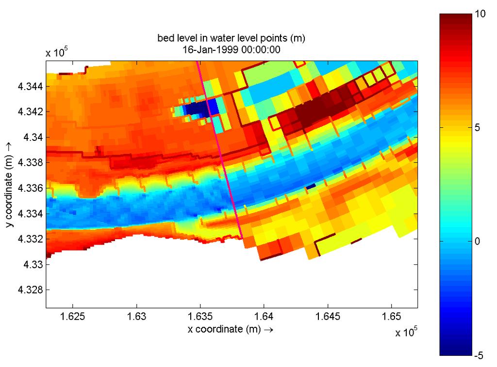
11 Computational grid
12 Case 2a: dam with side slope 1:2.5 (without openings) Dam with side slope without openings
 Dam with side slope")
13 Case 2b: dam with side slope 1:2.5 (with openings) Dam with side slope with openings
14 Input discharge hydrograph (8 discharge levels)


15 Q = 1409 m3/s Results (velocity field)
16 Bed level changes After 1 year
17 Bed level changes After 2 years
18 Bed level changes After 5 years
19 Bed level changes After 8 years
20 Bed level changes After 10 years Quick morphodynamic response (1-2 years)
21 Bed level changes With openings in dam Bed level change (m) Groyne lowering
 Potential steering parameter?")
22 Bed level changes Without openings in dam Bed level change (m) Potential steering parameter? Groyne lowering
23 Conclusions LDs may be a suitable alternative for wing dikes Maintain flow depths & sediment transport rates during low flows Quick morphodynamic response (1-2 years) Advantages over wing dikes are: LDs give less resistance to flow during high discharge events (lower flood levels) Additional flow area can be created behind the dams to lower flood levels LDs allow easy readjustment of inlets/outlets to correct for unwanted morphodynamic effects (minimize dredging efforts) Future studies of LDs should also focus on Combination of LD-designs and monitoring strategies to optimize LD-design (openings in dam) morphodynamics behind the LD in order to get insight into stability (or required maintenance) of LD-designs
24 Questions? Fredrik Huthoff
25 Changes in discharge capacity (with respect to current situation) Q = 3813 m3/s Correlates well with bed level changes
Development and application of demonstration MIKE 21C morphological model for a bend in Mekong River
 Development and application of demonstration MIKE 21C morphological model for a bend in Mekong River September 2015 0 Table of Contents 1. Introduction... 2 2. Data collection... 3 2.1 Additional data...
DVR toolbox for sediment management in the Rhine delta
 DVR toolbox for sediment management in the Rhine delta 1 DVR toolbox for sediment management in the Rhine delta Kees (C.J.) Sloff Abstract The DVR Toolbox is a modeling system developed to be used as an
FEWS-WATERWAYS: TOOL FOR SHARING DATA BETWEEN INLAND STAKEHOLDERS by Caroline F. van der Mark 1, Juzer Dhondia 2, Henk Verheij 3
 FEWS-WATERWAYS: TOOL FOR SHARING DATA BETWEEN INLAND STAKEHOLDERS by Caroline F. van der Mark 1, Juzer Dhondia 2, Henk Verheij 3 ABSTRACT This paper describes the FEWS-Waterways system for navigation that
Texas A & M University and U.S. Bureau of Reclamation Hydrologic Modeling Inventory Model Description Form
 Texas A & M University and U.S. Bureau of Reclamation Hydrologic Modeling Inventory Model Description Form JUNE, 1999 Name of Model: Two-Dimensional Alluvial River and Floodplain Model (MIKE21 CHD & CST)
Numerical modelling of morphological stability of proposed restoration measures along the Havel River
 Numerical modelling of morphological stability of proposed restoration measures along the Havel River Small scale morphological evolution of coastal, estuarine and rivers systems 6 7 October 2014, Nantes,
The importance of sediment supply data to modelling river morphodynamics
 The importance of sediment supply data to modelling river morphodynamics Wilbers & Ten Brinke (2003) bed elevation (m NAP) Pannerden channel Astrid Blom Delft University of Technology Netherlands Waal
Domino Effect of River Training in Large Sand-Bed Braiding Rivers
 6 th International Conference on Structural Engineering and Construction Management 2015, Kandy, Sri Lanka, 11 th -13 th December 2015 SECM/15/176 Domino Effect of River Training in Large Sand-Bed Braiding
ESTIMATION OF MORPHOLOGICAL IMPACT OF GROYNE LENGTHENING I. RÁTKY, ÉVA RÁTKY
 ESTIMATION OF MORPHOLOGICAL IMPACT OF GROYNE LENGTHENING I. RÁTKY, ÉVA RÁTKY Abstract. Hydraulic-morphological calculations in open channel flows still cause problems for modellers, partially because of
The effect of different gate opening patterns on reservoir flushing and morphological changes downstream a dam
 The effect of different gate opening patterns on reservoir flushing and morphological changes downstream a dam Amgad Y. A. Omer Ymkje Huismans Kees Sloff Yuichi Kitamura Deltares Deltares Deltares & TU
WORKSHOP #2 [Modeling and Sediment Transfers Review of alternative solutions] Bucharest 07 October 2015
![WORKSHOP #2 [Modeling and Sediment Transfers Review of alternative solutions] Bucharest 07 October 2015](/thumbs/82/85703998.jpg "WORKSHOP #2 [Modeling and Sediment Transfers Review of alternative solutions] Bucharest 07 October 2015") STUDIU DE FEZABILITATE PENTRU SOLUŢII TEHNICE ALTERNATIVE/COMPLEMENTARE PRIVIND LUCRĂRILE CE SE VOR EXECUTA ÎN PUNCTUL CRITIC 01 BALA DIN CADRUL PROIECTULUI ÎMBUNĂTĂŢIREA CONDIŢIILOR DE NAVIGAŢIE PE DUNĂRE
STUDIU DE FEZABILITATE PENTRU SOLUŢII TEHNICE ALTERNATIVE/COMPLEMENTARE PRIVIND LUCRĂRILE CE SE VOR EXECUTA ÎN PUNCTUL CRITIC 01 BALA DIN CADRUL PROIECTULUI ÎMBUNĂTĂŢIREA CONDIŢIILOR DE NAVIGAŢIE PE DUNĂRE
WL delft hydraulics. Voorspelinstrument duurzame vaarweg. Rijkswaterstaat RIZA. Prepared for:
 Prepared for: Rijkswaterstaat RIZA Voorspelinstrument duurzame vaarweg Report April Q357.3 WL delft hydraulics Prepared for: Rijkswaterstaat RIZA Voorspelinstrument duurzame vaarweg Mohamed Yossef, Migena
River bed classification using multi-beam echo-sounder backscatter data. Niels KINNEGING Rijkswaterstaat Centre for Water Management
 River bed classification using multi-beam echo-sounder backscatter data Niels KINNEGING Rijkswaterstaat Centre for Water Management Mirjam SNELLEN Delft University of Techonology Dimitrios ELEFTHERAKIS
Removal of riverbank protection along the River Rhine (the Netherlands)
") RR 2004 3rd European Conference on River Restoration RIVER RESTORATION 2004 Zagreb, Croatia, 17-21 May 2004 Removal of riverbank protection along the River Rhine (the Netherlands) L.J. Bolwidt, H.E.J.
RR 2004 3rd European Conference on River Restoration RIVER RESTORATION 2004 Zagreb, Croatia, 17-21 May 2004 Removal of riverbank protection along the River Rhine (the Netherlands) L.J. Bolwidt, H.E.J.
River bed classification using multi-beam echo-sounder backscatter data
 River bed classification using multi-beam echo-sounder backscatter data Niels Kinneging Mirjam Snellen Dimitrios Eleftherakis Dick Simons Erik Mosselman Arjan Sieben 13 November 2012 transport water management
Paper 114 Validation of Actual Depth Measurements by Inland Vessels
 Paper 114 Validation of Actual Depth Measurements by Inland Vessels VAN DER MARK C.F. 1 ; VIJVERBERG T. 2 ; OTTEVANGER W. 1 1 Deltares, Delft, the Netherlands 2 Royal HaskoningDHV, Amersfoort, the Netherlands
Stream Geomorphology. Leslie A. Morrissey UVM July 25, 2012
 Stream Geomorphology Leslie A. Morrissey UVM July 25, 2012 What Functions do Healthy Streams Provide? Flood mitigation Water supply Water quality Sediment storage and transport Habitat Recreation Transportation
WORKSHOP #2 Modelling and sediment transfers. Bucharest 07 October 2015
 STUDIU DE FEZABILITATE PENTRU SOLUŢII TEHNICE ALTERNATIVE/COMPLEMENTARE PRIVIND LUCRĂRILE CE SE VOR EXECUTA ÎN PUNCTUL CRITIC 01 BALA DIN CADRUL PROIECTULUI ÎMBUNĂTĂŢIREA CONDIŢIILOR DE NAVIGAŢIE PE DUNĂRE
Probabilistic Evaluation of a Meandering Low-Flow Channel. February 24 th, UMSRS
 Probabilistic Evaluation of a Meandering Low-Flow Channel February 24 th, 2014 2014 UMSRS 1 2 acknowledgments Low- Flow Channel (LFC) overview Proposed Diversion Channel collects runoff from: The Rush
EVALUATING EFFICIENCY OF THE RIVER NILE NAVIGATIONAL PATH
 International Water Technology Journal, IWTJ Vol. 7 No.3, September 217 EVALUATING EFFICIENCY OF THE RIVER NILE NAVIGATIONAL PATH Mohamed M. F. Sobeih 1, Nahla El-Saied Sadek 2, Esam El-Deen Y. Helal 3
Reactivation of Klingnau reservoir sidearm: Numerical simulation of sediment release downstream
 River Flow 2014 Schleiss et al. (Eds) 2014 Taylor & Francis Group, London, ISBN 978-1-138-02674-2 Reactivation of Klingnau reservoir sidearm: Numerical simulation of sediment release downstream A. Amini
Improvement of navigation conditions on the Danube (Calarasi-Braila and Lower Danube) - Ecological concerns?
 - Ecological concerns?") Improvement of navigation conditions on the Danube (Calarasi-Braila and Lower Danube) - Ecological concerns? Georg Rast, Christine Bratrich, Orieta Hulea WWF Germany/DCPO Topics of the presentation Major
Improvement of navigation conditions on the Danube (Calarasi-Braila and Lower Danube) - Ecological concerns? Georg Rast, Christine Bratrich, Orieta Hulea WWF Germany/DCPO Topics of the presentation Major
MATHEMATICAL MODELING OF FLUVIAL SEDIMENT DELIVERY, NEKA RIVER, IRAN. S.E. Kermani H. Golmaee M.Z. Ahmadi
 JOURNAL OF ENVIRONMENTAL HYDROLOGY The Electronic Journal of the International Association for Environmental Hydrology On the World Wide Web at http://www.hydroweb.com VOLUME 16 2008 MATHEMATICAL MODELING
Fluvial Processes in River Engineering
 Fluvial Processes in River Engineering Howard H. Chang San Diego State University... A WILEY-INTERSCIENCE PUBLTCATION John Wiley & Sons New York Chicbester Brisbane Toronto Singapore CONTENTS PARTI FLUVIAL
The simulation tool DredgeSim Predicting dredging needs in 2- and 3-dimensional models to evaluate dredging strategies
 River Flow 2010 - Dittrich, Koll, Aberle & Geisenhainer (eds) - 2010 Bundesanstalt für Wasserbau ISBN 978-3-939230-00-7 The simulation tool DredgeSim Predicting dredging needs in 2- and 3-dimensional models
Effect of Roughness on Discharge
 Effect of Roughness on Discharge T.W. Lau, and N.R. Afshar Abstract These Water resource projects and hydraulic engineering works have been developing rapidly throughout the world, thus prediction of water
CHANGES IN RIVER BED AROUND THE FUKAWA CONTRACTION AREA BY FLOODS AND CHANNEL IMPROVEMENT WORKS IN THE LOWER TONE RIVER
 The 1 th Int. Conf. on Hydroscience and Engineering (ICHE-212), Nov. 4 Nov. 7, Orlando, USA 1 CHANGES IN RIVER BED AROUND THE FUKAWA CONTRACTION AREA BY FLOODS AND CHANNEL IMPROVEMENT WORKS IN THE LOWER
MIKE 21C Morphological and Hydrodynamic Modeling Software and its application on River Loire and Labe
 Wasserbaukolloquium 2006: Strömungssimulation im Wasserbau Dresdner Wasserbauliche Mitteilungen Heft 32 117 MIKE 21C Morphological and Hydrodynamic Modeling Software and its application on River Loire
Scheepvaart en ecologische doelstellingen
 Scheepvaart en ecologische doelstellingen Margriet Schoor 25 April 2008 The Rhine Delta Rotterdam 2/3 1/3 Scheepvaart en ecologische doelstellingen 2 Germany Navigation on the Rhine Busiest river in Europe
Stage Discharge Prediction in a Prismatic Compound Channel
 International Journal of Civil Engineering Research. ISSN 2278-3652 Volume 5, Number 3 (2014), pp. 227-232 Research India Publications http://www.ripublication.com/ijcer.htm Stage Discharge Prediction
The Imperative of Sediment Management Concepts in River Basin Management Plans
 The Imperative of Sediment Management Concepts in River Basin Management Plans Stefan Vollmer, Thomas Hoffmann, Gudrun Hillebrand, Ina Quick, Axel Winterscheid Department M3 Groundwater, Geology, River
Impact of recent changes in river management on maintenance dredging in the Waal River
 i ii Impact of recent changes in river management on maintenance dredging in the Waal river By JAYESH KISOENSINGH MASTER OF SCIENCE In Civil Engineering Delft University of Technology Graduation Committee:
River Response. Sediment Water Wood. Confinement. Bank material. Channel morphology. Valley slope. Riparian vegetation.
 River Response River Response Sediment Water Wood Confinement Valley slope Channel morphology Bank material Flow obstructions Riparian vegetation climate catchment vegetation hydrological regime channel
ADH Sediment Module Testing
 ADH Sediment Module Testing By Jennifer N. Tate and R. C. Berger PURPOSE: The Kate Aubrey reach of the Mississippi River, located north of Memphis, TN, was used as a test domain for the ADaptive Hydraulics
Mississippi River West Bay Diversion Geomorphic Assessment and 1-D Modeling Plan
 Mississippi River West Bay Diversion Geomorphic Assessment and 1-D Modeling Plan Freddie Pinkard and Charlie Little Research Hydraulic Engineers ERDC-CHL-River Engineering Branch 27 February 2009 Lane
Appendix O. Sediment Transport Modelling Technical Memorandum
 Appendix O Sediment Transport Modelling Technical Memorandum w w w. b a i r d. c o m Baird o c e a n s engineering l a k e s design r i v e r s science w a t e r s h e d s construction Final Report Don
Morphological Changes of Reach Two of the Nile River
 ICHE 2014, Hamburg - Lehfeldt & Kopmann (eds) - 2014 Bundesanstalt für Wasserbau ISBN 978-3-939230-32-8 Morphological Changes of Reach Two of the Nile River E. Said Egyptian Environmental Affairs Agency,
Physical modelling of sediment transport in mountain torrents upstream of open check dams
 Physical modelling of sediment transport in mountain torrents upstream of open check dams Authors: Sebastian SCHWINDT Dr. Mário J. FRANCA Check dam in the region of Trent (Italy) Paper Code: EGU2015-6166
Sediment transport and river bed evolution
 1 Chapter 1 Sediment transport and river bed evolution 1.1 What is the sediment transport? What is the river bed evolution? System of the interaction between flow and river beds Rivers transport a variety
Morphodynamic Response of Tidal Mudflats to Marine Cohesive Sediment Influx
 Morphodynamic Response of Tidal Mudflats to Marine Cohesive Sediment Influx Wongsoredjo Samor Master of Science in Earth Sciences Thesis Utrecht, 2016 Utrecht University, Faculty of Geosciences Morphodynamic
Important Copyright Information
 Important Copyright Information The following content is provided for educational purposes by the workshop presenter. This content may or may not have been peer reviewed. Information, opinions and recommendations
The investigation of sediment processes in rivers by means of the Acoustic Doppler Profiler
 368 Evolving Water Resources Systems: Understanding, Predicting and Managing Water Society Interactions Proceedings of ICWRS014, Bologna, Italy, June 014 (IAHS Publ. 364, 014). The investigation of sediment
The SedAlp Project: WP6: INTERACTION WITH STRUCTURES
 The SedAlp Project: WP6: INTERACTION WITH STRUCTURES 6 th International conference Water in the Alps Herrenchiemsee, 12 th of October, 2016 Jošt Sodnik Contents Structure of SedAlp project (www.sedalp.eu)
Study on Flushing Mechanism of Dam Reservoir Sedimentation and Recovery of Riffle-Pool in Downstream Reach by a Flushing Bypass Tunnel
 Study on Flushing Mechanism of Dam Reservoir Sedimentation and Recovery of -Pool in Downstream Reach by a Flushing Bypass Tunnel Tomoo Fukuda Department of Science and Engineering, Chuo University, Tokyo,
Applicability of a coastal morphodynamic model for fluvial environments Beevers, Lindsay Catherine; Popescu, Ioana; Pan, Quan; Pender, Douglas
 Heriot-Watt University Heriot-Watt University Research Gateway Applicability of a coastal morphodynamic model for fluvial environments Beevers, Lindsay Catherine; Popescu, Ioana; Pan, Quan; Pender, Douglas
The Importance of Riparian Vegetation in Channel Restoration: Moving Towards Quantification in Design
 The Importance of Riparian Vegetation in Channel Restoration: Moving Towards Quantification in Design Rob Millar Department of Civil Engineering The University of British Columbia "Nothing is as practical
Annual transport rates at two locations on the fore-slope.
 Sediment Transport by Currents Fore-slope Sediment transport rates and sediment concentrations were computed from the hydrodynamic model runs as well as from direct measurements of current velocities at
Sediment transport in the Schelde-estuary: A comparison between measurements, transport formula and numerical models
 Sustainable Hydraulics in the Era of Global Change Erpicum et al. (Eds.) 2016 Taylor & Francis Group, London, ISBN 978-1-138-02977-4 Sediment transport in the Schelde-estuary: A comparison between measurements,
Strategies for managing sediment in dams. Iwona Conlan Consultant to IKMP, MRCS
 Strategies for managing sediment in dams Iwona Conlan Consultant to IKMP, MRCS 1 Sediment trapping by dams Active storage capacity Dead storage coarse material (bed load) Fine materials (suspension) Francis
NUMERICAL MODEL FOR MOVABLE BED AS A TOOL FOR THE SIMULATION OF THE RIVER EROSION A CASE STUDY
 NUMERICAL MODEL FOR MOVABLE BED AS A TOOL FOR THE SIMULATION OF THE RIVER EROSION A CASE STUDY Solichin 1 Abstract: A serious erosion problem takes place in Cipamingkis River in west Java, Indonesia. As
Stop 1: Marmot Dam Stop 1: Marmot Dam
 Stop 1: Marmot Dam Stop 1: Marmot Dam Following the removal of Marmot Dam in 2007, the fate of the reservoir sediments has been monitored through a series of surveys and sediment transport measurements.
Pilot-Project Project Bad Deutsch Altenburg:
 Pilot-Project Project Bad Deutsch Altenburg: River Restoration and Prevention of Riverbed-Erosion in the Danube Floodplain National Park (Austria) Stefan Schneeweihs Mohács, 2013 11 18 Pictures: F. Kovacs,
SCOPE OF PRESENTATION STREAM DYNAMICS, CHANNEL RESTORATION PLANS, & SEDIMENT TRANSPORT ANALYSES IN RELATION TO RESTORATION PLANS
 DESIGN METHODS B: SEDIMENT TRANSPORT PROCESSES FOR STREAM RESTORATION DESIGN PETER KLINGEMAN OREGON STATE UNIVERSITY CIVIL ENGINEERING DEPT., CORVALLIS 2 ND ANNUAL NORTHWEST STREAM RESTORATION DESIGN SYMPOSIUM
Upper Mississippi River Basin Environmental Management Program Workshop
 Presentation to the Upper Mississippi River Basin Environmental Management Program Workshop by Michael Rodgers River Engineer US Army Corps of Engineers, St. Louis District August 17, 2007 Engineering
 http://water.usgs.gov/waterwatch/ Stream Flow Measurement: Velocity-Area method Stream discharge = Q = U * A Q = volumetric flow rate in [L 3 T -1 ] U= average stream velocity [L 2 T -1 ] A = cross sectional
GEOL 1121 Earth Processes and Environments
 GEOL 1121 Earth Processes and Environments Wondwosen Seyoum Department of Geology University of Georgia e-mail: seyoum@uga.edu G/G Bldg., Rm. No. 122 Seyoum, 2015 Chapter 6 Streams and Flooding Seyoum,
Hindcasting morphodynamic evolution with sand mud interactions in the Yangtze Estuary
 doi:10.5194/piahs-368-430-2015 430 Remote Sensing and GIS for Hydrology and Water Resources (IAHS Publ. 368, 2015) (Proceedings RSHS14 and ICGRHWE14, Guangzhou, China, August 2014). Hindcasting morphodynamic
Bifurcation dynamics and avulsion duration in meandering rivers by one-dimensional and three-dimensional models
 WATER RESOURCES RESEARCH, VOL. 44,, doi:10.1029/2007wr005912, 2008 Bifurcation dynamics and avulsion duration in meandering rivers by one-dimensional and three-dimensional models M. G. Kleinhans, 1 H.
River Model (Delft3D)
") A Short River Model (Delft3D) & DIVERSION ANALYSIS presented by Nina J. Reins, PE, PhD, PMP State of the Coast May 30-June 1, 2018 Overview of Presentation Problem Statement & Background Analysis Key Findings
A Short River Model (Delft3D) & DIVERSION ANALYSIS presented by Nina J. Reins, PE, PhD, PMP State of the Coast May 30-June 1, 2018 Overview of Presentation Problem Statement & Background Analysis Key Findings
EFFECT OF TWO SUCCESIVE CHECK DAMS ON DEBRIS FLOW DEPOSITION
 DOI: 10.4408/IJEGE.2011-03.B-116 EFFECT OF TWO SUCCESIVE CHECK DAMS ON DEBRIS FLOW DEPOSITION Farouk Maricar (*), Haruyuki Hashimoto (*), Shinya Ikematsu (*) & Tomohiro Miyoshi (*) (*) Department of Civil
Three-dimensional CFD modeling of morphological bed changes in the Danube River
 WATER RESOURCES RESEARCH, VOL. 44,, doi:10.1029/2007wr006402, 2008 Three-dimensional CFD modeling of morphological bed changes in the Danube River Tim Fischer-Antze, 1 Nils Reidar B. Olsen, 2 and Dieter
Temporal variability of partially-contaminated sediments in a strongly regulated reservoir of the upper Rhine River
 Temporal variability of partially-contaminated sediments in a strongly regulated reservoir of the upper Rhine River Germain Antoine 1,2,, Thomas Pretet 1,3,, Matthieu Secher 3,, and Anne Clutier 3, 1 Laboratoire
Towards the prediction of free-forming meander formation using 3D computational fluid dynamics
 Wasserbaukolloquium 2006: Strömungssimulation im Wasserbau 31 Dresdner Wasserbauliche Mitteilungen Heft 32 Towards the prediction of free-forming meander formation using 3D computational fluid dynamics
On the lateral variability of bed-load transport in the Niederrhein
 On the lateral variability of bed-load transport in the Niederrhein and its implications for measurement strategies Roy Frings, Christian Beckhausen Institute of Hydraulic Engineering and Water Resources
A STUDY OF LOCAL SCOUR AT BRIDGE PIERS OF EL-MINIA
 A STUDY OF LOCAL SCOUR AT BRIDGE PIERS OF EL-MINIA Dr. Gamal A. Sallam 1 and Dr. Medhat Aziz 2 ABSTRACT Bridges are critical structures that require a substantial investment to construct and serve an important
Technical Review of Pak Beng Hydropower Project (1) Hydrology & Hydraulics and (2) Sediment Transport & River Morphology
 Hydrology & Hydraulics and (2) Sediment Transport & River Morphology") Technical Review of Pak Beng Hydropower Project (1) Hydrology & Hydraulics and (2) Sediment Transport & River Morphology The 2 nd Regional Stakeholder Forum The Pak Beng Hydropower Project 5 th May 2017
Technical Review of Pak Beng Hydropower Project (1) Hydrology & Hydraulics and (2) Sediment Transport & River Morphology The 2 nd Regional Stakeholder Forum The Pak Beng Hydropower Project 5 th May 2017
Introduction to BASEMENT Basic Simulation Environment for Computation of Environmental Flow and Natural Hazard Simulation
 Introduction to BASEMENT Basic Simulation Environment for Computation of Environmental Flow and Natural Hazard Simulation Numerical Hydraulics Autumn semester 2016 Prof. Dr. Markus Holzner Author: Pascal
Modeling of long-term sedimentation in the Osijek port basin
 Water Management and Hydraulic Engineering 2015 Litera Brno, ISBN 978-80-214-5230-5, ISSN 2410-5910 Modeling of long-term sedimentation in the Osijek port basin G. Gilja, N. Kuspilić (Faculty of civil
Licca Liber - the free Lech
 Licca Liber - the free Lech Source: W. Schilling WWA Donauwörth The river Lech an overview Hydrography / Hydrology catchment area 4000 km² Length 256 km Delta H 1100 m Slope Ø 0,4 % discharge in Augsburg
Dealing with Sedimental Transport Over Partly Non-Erodible Bottoms
 Utah State University DigitalCommons@USU International Junior Researcher and Engineer Workshop on Hydraulic Structures Jun 17th, 12:00 AM - Jun 20th, 12:00 AM Dealing with Sedimental Transport Over Partly
CHAPTER 126 ^^^C^SR, SEDIMENTATION STUDIES ON THE NIGER RIVER DELTA
 CHAPTER 126 SEDIMENTATION STUDIES ON THE NIGER RIVER DELTA Ramiro Mayor-Mora, D. Eng. (1) Preben Mortensen, M.Sc. (2) Jorgen Fredsoe, M.Sc. (2) 1. Introduction An area of the Niger River Delta was studied
What? River response to base level rise. The morphodynamic system. Why? Channel-forming discharge. Flow. u = What s in a name. Flow Sediment transport
 River response to base level rise and other boundary conditions Dr. Maarten Kleinhans Summer course climate change and fluvial systems Course materials of Prof. Gary Parker Flow Sediment transport What?
Quasi-three dimensional computations for flows and bed variations in curved channel with gently sloped outer bank
 River Sedimentation Wieprecht et al. (Eds) 2017 Taylor & Francis Group, London, ISBN 978-1-138-02945-3 Quasi-three dimensional computations for flows and bed variations in curved channel with gently sloped
VICTORIA BEND HYDRAULIC SEDIMENT RESPONSE MODEL INVESTIGATION LOWER MISSISSIPPI RIVER MILES
 Technical Report M48 VICTORIA BEND HYDRAULIC SEDIMENT RESPONSE MODEL INVESTIGATION LOWER MISSISSIPPI RIVER MILES 600-590 By Peter M. Russell, P.E. Jasen L. Brown, P.E Edward J. Brauer, P.E. Robert D. Davinroy,
Diagnostic Geomorphic Methods for Understanding Future Behavior of Lake Superior Streams What Have We Learned in Two Decades?
 Diagnostic Geomorphic Methods for Understanding Future Behavior of Lake Superior Streams What Have We Learned in Two Decades? Faith Fitzpatrick USGS WI Water Science Center, Middleton, WI fafitzpa@usgs.gov
The use of MIKE21 to study the. barrier beach system of Inner Dingle Bay, Co. Kerry, Ireland. Dr. Michael O Shea Malachy Walsh and Partners
 The use of MIKE21 to study the morphodynamic evolution of the mid-bay barrier beach system of Inner Dingle Bay, Co. Kerry, Ireland Dr. Michael O Shea Malachy Walsh and Partners Contents Why Study Morphodynamics
Tarbela Dam in Pakistan. Case study of reservoir sedimentation
 Tarbela Dam in Pakistan. HR Wallingford, Wallingford, UK Published in the proceedings of River Flow 2012, 5-7 September 2012 Abstract Reservoir sedimentation is a main concern in the Tarbela reservoir
Evaluation of Dredging Operations for Tigris River within Baghdad, Iraq
 Journal of Water Resource and Protection, 2014, 6, 202-213 Published Online March 2014 in SciRes. http://www.scirp.org/journal/jwarp http://dx.doi.org/10.4236/jwarp.2014.64026 Evaluation of Dredging Operations
ANALYSIS OF CURRENT PATTERNS IN COASTAL AREAS USING X-BAND RADAR IMAGES
 ANALYSIS OF CURRENT PATTERNS IN COASTAL AREAS USING X-BAND RADAR IMAGES Cilia Swinkels 1, Herman Peters 2 and Jos van Heesen 3 The Seadarq software from Nortek is designed to derive wave, water depth and
!"#$%&&'()*+#$%(,-./0*)%(!
*+#$%(,-./0*)%(!") 8:30 Sign in Hoosic River Revival Coalition!"#$%&&'()*+#$%(,-./0*)%(! 12-#30+4/#"5-(60 9:00 Welcome and Introductions 9:15 Goals for Today s Program: A Description of the Planning Process 9:30 First Session:
8:30 Sign in Hoosic River Revival Coalition!"#$%&&'()*+#$%(,-./0*)%(! 12-#30+4/#"5-(60 9:00 Welcome and Introductions 9:15 Goals for Today s Program: A Description of the Planning Process 9:30 First Session:
General discussion and conclusions
 CHAPTER 9 ~ DISCUSSION AND CONCLUSIONS 177 General discussion and conclusions 9 This study followed a functional-geographical approach to research into river rehabilitation and to expand our knowledge
Sediment and Water Quality in HEC-RAS. Mark Jensen
 Sediment and Water Quality in HEC-RAS Mark Jensen The HEC-RAS Modeling System 1D River Hydraulics Graphical User Interface Steady & Unsteady Flow Bridges, Culverts, Dams, weirs, gates, etc Data storage/management
MORPHOLOGICAL PROCESSES AND EFFECTIVE RIVER EROSION MANAGEMENT: A CASE STUDY OF THE ARIAL KHAN RIVER IN BANGLADESH
 MORPHOLOGICAL PROCESSES AND EFFECTIVE RIVER EROSION MANAGEMENT: A CASE STUDY OF THE ARIAL KHAN RIVER IN BANGLADESH Jakia Akter* 1, Maminul Haque Sarker, Preetha Haque 1 Center for environmental and Geographic
Calculation of Stream Discharge Required to Move Bed Material
 Calculation of Stream Discharge Required to Move Bed Material Objective: Students will map two sections of a stream and calculate the depth, velocity, and discharge of flows required to move the stream
Laboratory Investigation of Submerged Vane Shapes Effect on River Banks Protection
 Australian Journal of Basic and Applied Sciences, 5(12): 1402-1407, 2011 ISSN 1991-8178 Laboratory Investigation of Submerged Vane Shapes Effect on River Banks Protection Touraj Samimi Behbahan Department
Sediment trapping efficiency of modular steel check dam in laboratory experiment and field observation
 Sediment trapping efficiency of modular steel check dam in laboratory experiment and field observation Su-Chin CHEN 1, Hiroshi KOKURYO 2, Shuan-Pei AN 1, Sheng-Jui LU 1, and Hui-Kai HUANG 1* 1 Department
Stream Restoration and Environmental River Mechanics. Objectives. Pierre Y. Julien. 1. Peligre Dam in Haiti (deforestation)
") Stream Restoration and Environmental River Mechanics Pierre Y. Julien Malaysia 2004 Objectives Brief overview of environmental river mechanics and stream restoration: 1. Typical problems in environmental
Stream Restoration and Environmental River Mechanics Pierre Y. Julien Malaysia 2004 Objectives Brief overview of environmental river mechanics and stream restoration: 1. Typical problems in environmental
 Red River Flooding June 2015 Caddo and Bossier Parishes Presented by: Flood Technical Committee Where the Rain Falls Matters I-30 versus I-20 I-20 Backwater and Tributary Floods (Localized) 2016 Flood
Influence of the Major Drainages to the Mississippi River and Implications for System Level Management
 Influence of the Major Drainages to the Mississippi River and Implications for System Level Management Brian M. Vosburg Geologist Louisiana Coastal Protection and Restoration Authority brian.vosburg@la.gov
Dr Benjamin Dewals, Ir Sylvain Detrembleur, Dr P. Archambeau, Ir L. Gouverneur & Prof. M. Pirotton
 Dr Benjamin Dewals, Ir Sylvain Detrembleur, Dr P. Archambeau, Ir L. Gouverneur & Prof. M. Pirotton Content Hydraulic modelling within AMICE Existing models and modelling procedures Transnational modelling
Why Geomorphology for Fish Passage
 Channel Morphology - Stream Crossing Interactions An Overview Michael Love Michael Love & Associates mlove@h2odesigns.com (707) 476-8938 Why Geomorphology for Fish Passage 1. Understand the Scale of the
Numerical modelling of the geologically reconstructed Oer-IJ estuary.
 Numerical modelling of the geologically reconstructed Oer-IJ estuary. MSc Thesis Bas Bodewes Student number: 3507874 June 2013 December 2014 Master: Earth Surface and Water Track: Coastal dynamics and
Morphological Modeling of Inlets and Adjacent Shorelines on Engineering Timescales
 CB&I Morphological Modeling of Inlets and Adjacent Shorelines on Engineering Timescales Challenges and Model Improvements based on Recent Studies Dobrochinski, J.P.H.; Benedet, L.; Signorin, M.; Pierro,
Modelling of flow and sediment transport in rivers and freshwater deltas Peggy Zinke
 1 Modelling of flow and sediment transport in rivers and freshwater deltas Peggy Zinke with contributions from Norwegian and international project partners 2 Outline 1. Introduction 2. Basic ideas of flow
COMPARISON OF SCOUR AROUND DIFFERENT SHAPES OF GROYNES IN OPEN CHANNEL
 COMPARISON OF SCOUR AROUND DIFFERENT SHAPES OF GROYNES IN OPEN CHANNEL Thangamani Vijaya Kumar 1, Devesh Tyagi 2, Lokesh Aggarwal 3, Munendra Kumar 4 1,2,3,4 Department of Civil Engineering, Delhi Technological
River Nith restoration, cbec UK Ltd, October 2013 APPENDIX A
 APPENDIX A FLUVIAL AUDIT METHOD STATEMENT Fluvial Audit Methodology INTRODUCTION The procedure used to characterize the geomorphic and sedimentary regimes of the River Till is an adaptation of the Fluvial
Appendix D. Summary of Hydrodynamic, Sediment Transport, and Wave Modeling
 Appendix D Summary of Hydrodynamic, Sediment Transport, and Wave Modeling Appendix D Summary of Hydrodynamic, Sediment Transport, and Wave Modeling Spirit Lake Sediment Site Prepared for U. S. Steel Corporation
Coastal and Hydraulics Laboratory
 SAM Hydraulic Design Package for Channels Coastal and Hydraulics Laboratory William A. Thomas, Ronald R. Copeland, and Dinah N. McComas September 2002 Approved for public release; distribution is unlimited.
Squaw Creek. General Information
 General Information is a tributary to the Salmon River. It enters the north side of the river about 0 miles downstream of North Fork, Idaho. The study reach is about a 30 ft length of stream about 2 miles
Modeling Sediment Accumulation at Kenyir Reservoir Using GSTARS3
 ISSN (e): 2250 3005 Vol, 04 Issue, 10 October 2014 International Journal of Computational Engineering Research (IJCER) Modeling Sediment Accumulation at Kenyir Reservoir Using GSTARS3 Manal M.A. Albayati
Run 028 (Note: error in UKC at start of exercise due incorrect tide input then corrected ok.)
") Run 027 RNZ Full Bridge Simulation Run Plots Final Report Be-Software August 2016 Prepared for Royal Haskoning DHV on behalf of Refining New Zealand Limited 27 Run 028 (Note: error in UKC at start of exercise
Run 027 RNZ Full Bridge Simulation Run Plots Final Report Be-Software August 2016 Prepared for Royal Haskoning DHV on behalf of Refining New Zealand Limited 27 Run 028 (Note: error in UKC at start of exercise