Sediment and Water Quality in HEC-RAS. Mark Jensen
|
|
|
- Christina Atkinson
- 5 years ago
- Views:
Transcription
1 Sediment and Water Quality in HEC-RAS Mark Jensen

2 The HEC-RAS Modeling System 1D River Hydraulics Graphical User Interface Steady & Unsteady Flow Bridges, Culverts, Dams, weirs, gates, etc Data storage/management Graphics, Tabular Output & Reporting GeoRas ArcGIS
3 History of HEC-RAS Development 1D Steady Flow Analysis FY Produced Steady flow versions of HEC-RAS (Beta 1&2, Versions , ) 1D Unsteady Modeling for River Analysis FY Versions D Sediment Transport for River Analysis FY D Water Quality Modeling FY
4 Features added to recent versions of HEC-RAS Mixed Flow Regime for Unsteady Flow Dam Break Analysis Levee Breaching Pump Stations Navigation Dams Stable Channel Design and Analysis Sediment Transport Potential
5 New HEC-RAS Developments (that we will be talking about today) Sediment Transport (Mobile Bed Hydraulics) Water Quality
6 Mobile Bed Sediment Transport Goals of adding sediment routing into HEC-RAS Quasi-Steady Hydrodynamics Transport Capacity Sediment continuity Sorting and Armoring Erosion and Deposition User Interface Design Preliminary Results Additional Capabilities Planned
7 Goals of adding Mobile Bed Capabilities into HEC-RAS Replicate the capabilities of HEC-6 Re-coding general capabilities in RAS Differences exist in hydraulic computations Add new capabilities beyond current HEC-6 Features Improve the capabilities where we have known deficiencies
8 Quasi-Steady Flow Flow Hydrograph represented by a series of steady flows associated with durations. Requires a new way of handling flows in HEC RAS
9 Computational Time Steps Flow Increment Q Computational Time Step Time
10 Transport Potential Functions Ackers-White Englund-Hansen Laursen (Copeland) Myer-Peter-Meuler Toffaleti Yang (Sand and Gravel)
11 Transport Capacity Bed Material and Inflowing Load divided into separate grain classes (up to 20) Transport potential is calculated for each grain size Transport Capacity = (Transport Potential for each grain size) X (fraction of that material in active layer of bed)
12 Sediment Continuity: Exner Equation (1 ) B p = t Q x s H
13 Sorting and Armoring Cover Layer Subsurface Layer Inactive Layer Bedrock Layer Active Layer Diagramed and Conceptualized HEC 6 Code 3 Methods in HEC-6T Exner 5 implemented Currently in RAS
14 Temporal Constraints on Eroding and Depositing Erosion and deposition does not occur instantaneously. Deposition is based on settling velocity: Deposition efficiency coefficient = Erosion is based on Characteristic Flow Length Erosion = (Gs Qs) x C e Where: C e = V s ( i ) ( i ) D Entrainment Coefficient e L 30 D e t
15 Erosion and Deposition to RAS Cross Sections Deposition RAS computations modified to compute bed changes and modify cross sections before each time step Cross Sections Bridges Erosion

16 Sediment User Interface
 50 40 30 20 10 0 0 2 4 6 8 10")
17 Simple Transport Example Flow Series Flow (cfs) Days
18 Animation of Bed Movement

19 Time Series of Bed Elevation at a Single XS
20 Water Quality
21 Water Quality (Temperature) Model Based on unreleased version of CE-QUAL-RIV1 QUICKEST-ULTIMATE numerical scheme Finite Volume Variable grid size Automatic time step selection Full energy budget for Temperature Working with ERDC to use a common Nutrient Model
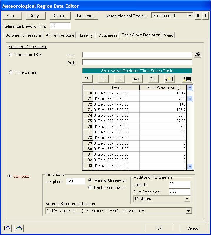
22 Meteorological Data Editor Solar Radiation
23 Source/Sink Term for Temperature (Energy Budget) solar radiation (qsw) net longwave radiation (qlw) sensible heat (qh) f (site location, time of day, day of year, atmospheric turbidity, cloud cover) f (air temperature, water temperature) f (temperature gradient, wind, a&b) latent heat (qe) f (vapor pressure gradient, wind, a&b) q = q + q + q + net sw lwn h q e Planned: ground heat conduction shading (topographic, riparian)


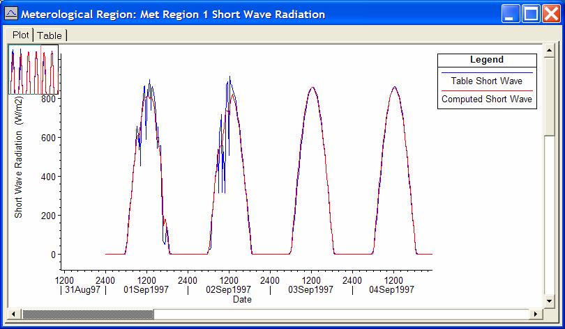
24 Time Series Plots Water temperature Solar Radiation

25 Plot of Energy Budget Terms Net Heat Flux Shortwave Radiation Longwave Down Energy Budget Profiles Sensible Heat Evaporation Longwave Up Component Outputs can be Viewed Separately

26 Profile Plot of Temperature 1 day travel time distance River approx. 60,000 m Profile velocity approx m/s

27 Map View of Temperature in Sacramento River
Determining the Suitable Sediment extraction Locations of Existing Sand and Gravel Mines on Boshar River in Iran using HEC-RAS Modeling
 ICSE6-134 Determining the Suitable Sediment extraction Locations of Existing Sand and Gravel Mines on Boshar River in Iran using HEC-RAS Modeling Mohammad GHARESIFARD 1, Ali JAHEDAN 2, Bahar MOLAZEM 3
3 Theoretical Basis for SAM.sed Calculations
 3 Theoretical Basis for SAM.sed Calculations Purpose Sediment transport functions can be used to calculate the bed material portion of the sediment discharge rating curve. This rating curve can then be
Lower Susquehanna River Reservoir System Proposed Modeling Enhancements
 Lower Susquehanna River Reservoir System Proposed Modeling Enhancements Presented at the Chesapeake Bay Program Scientific and Technical Advisory Committee (STAC) Workshop January 13, 2016 Overview Due
MATHEMATICAL MODELING OF FLUVIAL SEDIMENT DELIVERY, NEKA RIVER, IRAN. S.E. Kermani H. Golmaee M.Z. Ahmadi
 JOURNAL OF ENVIRONMENTAL HYDROLOGY The Electronic Journal of the International Association for Environmental Hydrology On the World Wide Web at http://www.hydroweb.com VOLUME 16 2008 MATHEMATICAL MODELING
APPLICATION OF HEC-RAS MODEL FOR ESTIMATING CHANGES IN WATERCOURSE GEOMETRY DURING FLOODS
 Studia Geotechnica et Mechanica, Vol. XXXIV, No. 2, 2012 DOI: 105277/sgm021206 APPLICATION OF HEC-RAS MODEL FOR ESTIMATING CHANGES IN WATERCOURSE GEOMETRY DURING FLOODS JOANNA MARKOWSKA Department of Environmental
7.3 Sediment Delivery Analysis
 7.3 Sediment Delivery Analysis In order to evaluate potential changes in sedimentation patterns that could occur due to impacts from the FCP and LPP alignments, sediment assessment models were constructed
Mississippi River West Bay Diversion Geomorphic Assessment and 1-D Modeling Plan
 Mississippi River West Bay Diversion Geomorphic Assessment and 1-D Modeling Plan Freddie Pinkard and Charlie Little Research Hydraulic Engineers ERDC-CHL-River Engineering Branch 27 February 2009 Lane
Technical Memorandum No
 Pajaro River Watershed Study in association with Technical Memorandum No. 1.2.10 Task: Evaluation of Four Watershed Conditions - Sediment To: PRWFPA Staff Working Group Prepared by: Gregory Morris and
HEC-RAS Reservoir Transport Simulation of Three Reservoirs in the Lower Susquehanna River Basin. Mike Langland and Ed Koerkle
 HEC-RAS Reservoir Transport Simulation of Three Reservoirs in the Lower Susquehanna River Basin Mike Langland and Ed Koerkle Topics Background / Project Objectives Data Selection - Sediment and Geometric
* Chapter 10 Nonequilibrium Sediment Transport
 Chapter 10 Nonequilibrium Sediment Transport Section I Introduction 10-1. General Nonequilibrium sediment transport refers to cases where the outflowing sediment discharge from a reach does not equal the
Technical Memorandum No Sediment Model
 Pajaro River Watershed Study in association with Technical Memorandum No. 1.2.9 Sediment Model Task: Development of Sediment Model To: PRWFPA Staff Working Group Prepared by: Gregory Morris and Elsie Parrilla
Summary of Hydraulic and Sediment-transport. Analysis of Residual Sediment: Alternatives for the San Clemente Dam Removal/Retrofit Project,
 Appendix N SUMMARY OF HYDRAULIC AND SEDIMENT-TRANSPORT ANALYSIS OF RESIDUAL SEDIMENT: ALTERNATIVES FOR THE SAN CLEMENTE DAM REMOVAL/RETROFIT PROJECT, CALIFORNIA the San Clemente Dam Removal/Retrofit Project,
International Journal of Scientific & Engineering Research, Volume 6, Issue 3, March ISSN
 International Journal of Scientific & Engineering Research, Volume 6, Issue 3, March-2015 1338 Modeling of Sediment Transport Upstream of Al- Shamia Barrage Prof. Dr. Saleh I. Khassaf, Mohammed jaber Abbas
B-1. Attachment B-1. Evaluation of AdH Model Simplifications in Conowingo Reservoir Sediment Transport Modeling
 Attachment B-1 Evaluation of AdH Model Simplifications in Conowingo Reservoir Sediment Transport Modeling 1 October 2012 Lower Susquehanna River Watershed Assessment Evaluation of AdH Model Simplifications
Hydrologic Analysis for Ecosystem Restoration
 Hydrologic Analysis for Ecosystem Restoration Davis, California Objectives: To provide participants with: 1) an understanding of the issues in restoration studies; 2) an overview of Corps policies and
(3) Sediment Movement Classes of sediment transported
 Sediment Movement Classes of sediment transported") 9/17/15 (3) Sediment Movement Classes of sediment transported Dissolved load Suspended load Important for scouring algae Bedload (5-10% total load) Moves along bed during floods Source of crushing for
9/17/15 (3) Sediment Movement Classes of sediment transported Dissolved load Suspended load Important for scouring algae Bedload (5-10% total load) Moves along bed during floods Source of crushing for
Reactivation of Klingnau reservoir sidearm: Numerical simulation of sediment release downstream
 River Flow 2014 Schleiss et al. (Eds) 2014 Taylor & Francis Group, London, ISBN 978-1-138-02674-2 Reactivation of Klingnau reservoir sidearm: Numerical simulation of sediment release downstream A. Amini
Applying GIS to Hydraulic Analysis
 Texas A&M University Department of Civil Engineering CVEN689 Applications of GIS to Civil Engineering Instructor: Francisco Olivera, Ph.D., P.E. Applying GIS to Hydraulic Analysis Lim, Chae Kwan April
Coarse Sediment Augmentation on Regulated Rivers. Scott McBain McBain & Trush, Inc.
 Coarse Sediment Augmentation on Regulated Rivers Scott McBain McBain & Trush, Inc. scott@mcbaintrush.com Components Some geomorphic and ecological considerations Conceptual approach at understanding augmentation
Sediment and Nutrient Mass Balance Model of ConowingoPool
 Sediment and Nutrient Mass Balance Model of ConowingoPool Mark Velleux and Jim Fitzpatrick HDR Engineering Chesapeake Bay Program Modeling Quarterly Review: August 10, 2016 Model Grid and Spatial Resolution
Sediment Transport Analysis for Stream Restoration Design: The Good, the Bad, and the Ugly.
 Sediment Transport Analysis for Stream Restoration Design: The Good, the Bad, and the Ugly. Brett Jordan Phd, PE HydroGeo Designs LLC. Land and Water Services Inc. THE GOOD THE BAD THE UGLY THE GOOD THE
Hydraulic and Sediment Transport Modeling Strategy
 Appendix B Hydraulic and Sediment Transport Modeling Strategy May 2014 Technical Memorandum Channel Capacity Report January 2015 San Joaquin River Restoration Program Hydraulic and Sediment Transport Modeling
LAR BPWG. DWR Erosion Screening Process Application to LAR. May 17, water resource specialists
 LAR BPWG DWR Erosion Screening Process Application to LAR May 17, 2016 Presentation Outline Review of Erosion Screening Process Modifications for LAR Application ESP LAR Results Recommendations ESP Background
Modeling of long-term sedimentation in the Osijek port basin
 Water Management and Hydraulic Engineering 2015 Litera Brno, ISBN 978-80-214-5230-5, ISSN 2410-5910 Modeling of long-term sedimentation in the Osijek port basin G. Gilja, N. Kuspilić (Faculty of civil
Modelling of flow and sediment transport in rivers and freshwater deltas Peggy Zinke
 1 Modelling of flow and sediment transport in rivers and freshwater deltas Peggy Zinke with contributions from Norwegian and international project partners 2 Outline 1. Introduction 2. Basic ideas of flow
Texas A & M University and U.S. Bureau of Reclamation Hydrologic Modeling Inventory Model Description Form
 Texas A & M University and U.S. Bureau of Reclamation Hydrologic Modeling Inventory Model Description Form JUNE, 1999 Name of Model: Two-Dimensional Alluvial River and Floodplain Model (MIKE21 CHD & CST)
Development, Testing and Application of the Multi-Block LTFATE Hydrodynamic and Sediment Transport Model
 Development, Testing and Application of the Multi-Block LTFATE Hydrodynamic and Sediment Transport Model Earl Hayter Environmental Lab October 25, 2012 LTFATE Multi-Block Hydrodynamic, Water Quality and
Lecture notes: Interception and evapotranspiration
 Lecture notes: Interception and evapotranspiration I. Vegetation canopy interception (I c ): Portion of incident precipitation (P) physically intercepted, stored and ultimately evaporated from vegetation
- matter-energy interactions. - global radiation balance. Further Reading: Chapter 04 of the text book. Outline. - shortwave radiation balance
 (1 of 12) Further Reading: Chapter 04 of the text book Outline - matter-energy interactions - shortwave radiation balance - longwave radiation balance - global radiation balance (2 of 12) Previously, we
Two-Dimensional Simulation of Truckee River Hydrodynamics
 Two-Dimensional Simulation of Truckee River Hydrodynamics by Stephen H. Scott PURPOSE: The purpose of this Coastal and Hydraulics Engineering Technical Note (CHETN) is to demonstrate the use of multidimensional
A STUDY OF LOCAL SCOUR AT BRIDGE PIERS OF EL-MINIA
 A STUDY OF LOCAL SCOUR AT BRIDGE PIERS OF EL-MINIA Dr. Gamal A. Sallam 1 and Dr. Medhat Aziz 2 ABSTRACT Bridges are critical structures that require a substantial investment to construct and serve an important
WQMAP (Water Quality Mapping and Analysis Program) is a proprietary. modeling system developed by Applied Science Associates, Inc.
 is a proprietary. modeling system developed by Applied Science Associates, Inc.") Appendix A. ASA s WQMAP WQMAP (Water Quality Mapping and Analysis Program) is a proprietary modeling system developed by Applied Science Associates, Inc. and the University of Rhode Island for water quality
Appendix A. ASA s WQMAP WQMAP (Water Quality Mapping and Analysis Program) is a proprietary modeling system developed by Applied Science Associates, Inc. and the University of Rhode Island for water quality
Lower Susquehanna River Integrated Sediment & Nutrient Monitoring Program
 Lower Susquehanna River Integrated Sediment & Nutrient Monitoring Program Presented at the Chesapeake Bay Program Scientific and Technical Advisory Committee (STAC) Workshop January 13, 2016 Background
Coastal and Hydraulics Laboratory
 SAM Hydraulic Design Package for Channels Coastal and Hydraulics Laboratory William A. Thomas, Ronald R. Copeland, and Dinah N. McComas September 2002 Approved for public release; distribution is unlimited.
Final Report for TWDB Contract No
 Final Report for TWDB Contract No. 1004831127 Sediment Transport Modeling of Channel Scale Geomorphic Processes J.K. Haschenburger University of Texas at San Antonio July 31, 2012 1 Introduction This study
Block 6 Heat transport in rivers
 Numerical Hydraulics Block 6 Heat transport in rivers Markus Holzner Contents of the course Block 1 The equations Block 2 Computation of pressure surges Block 3 Open channel flow (flow in rivers) Block
MODELING OF LOCAL SCOUR AROUND AL-KUFA BRIDGE PIERS Saleh I. Khassaf, Saja Sadeq Shakir
 ISSN 2320-9100 11 International Journal of Advance Research, IJOAR.org Volume 1, Issue 8,August 2013, Online: ISSN 2320-9100 MODELING OF LOCAL SCOUR AROUND AL-KUFA BRIDGE PIERS Saleh I. Khassaf, Saja Sadeq
MEMORANDUM 1. INTRODUCTION
 MEMORANDUM TO: Jim Well, Ducks Unlimited FROM: Mike Harvey, PhD, PG, Bob Mussetter, PhD, PE, Dai Thomas, PE SUBJECT: Two-dimensional Sediment-transport Modeling of the M&T/Llano Project No. US-CA-62-2
ADH Sediment Module Testing
 ADH Sediment Module Testing By Jennifer N. Tate and R. C. Berger PURPOSE: The Kate Aubrey reach of the Mississippi River, located north of Memphis, TN, was used as a test domain for the ADaptive Hydraulics
Numerical modeling of sediment flushing from Lewis and Clark Lake
 University of Nebraska - Lincoln DigitalCommons@University of Nebraska - Lincoln US Army Research U.S. Department of Defense 2013 Numerical modeling of sediment flushing from Lewis and Clark Lake Jungkyu
LAKE CLARKE AND LAKE ALDRED SEDIMENT TRANSPORT MODELING FINAL REPORT
 LAKE CLARKE AND LAKE ALDRED SEDIMENT TRANSPORT MODELING FINAL REPORT Safe Harbor Dam, 2011 Conestoga River Mouth Holtwood Dam, September 10, 2011 Prepared by: WEST CONSULTANTS, INC. May 2017 Lake Clarke
Surface Processes Focus on Mass Wasting (Chapter 10)
") Surface Processes Focus on Mass Wasting (Chapter 10) 1. What is the distinction between weathering, mass wasting, and erosion? 2. What is the controlling force in mass wasting? What force provides resistance?
Surface Processes Focus on Mass Wasting (Chapter 10) 1. What is the distinction between weathering, mass wasting, and erosion? 2. What is the controlling force in mass wasting? What force provides resistance?
How to predict the sedimentological impacts of reservoir operations?
 ICSE 212 How to predict the sedimentological impacts of reservoir operations? E. Valette EDF CIH eric.valette@edf.fr M. Jodeau EDF R&D LNHE magali.jodeau@edf.fr Presentation of the numerical code Courlis
NUMERICAL MODEL FOR MOVABLE BED AS A TOOL FOR THE SIMULATION OF THE RIVER EROSION A CASE STUDY
 NUMERICAL MODEL FOR MOVABLE BED AS A TOOL FOR THE SIMULATION OF THE RIVER EROSION A CASE STUDY Solichin 1 Abstract: A serious erosion problem takes place in Cipamingkis River in west Java, Indonesia. As
Objectives This tutorial demonstrates how to perform sediment transport simulations in SRH-2D.
 SMS v. 12.2 SRH-2D Tutorial Objectives This tutorial demonstrates how to perform sediment transport simulations in SRH-2D. Prerequisites SMS Overview tutorial SRH-2D Requirements SRH-2D Model Map Module
Riverine Modeling Proof of Concept
 Technical Team Meeting Riverine Modeling Proof of Concept Version 2 HEC-RAS Open-water Flow Routing Model April 15-17, 2014 Prepared by R2 Resource Consultants, Brailey Hydrologic, Geovera, Tetra Tech,
Dam Removal Analysis Guidelines for Sediment
 A review of: Dam Removal Analysis Guidelines for Sediment Joe Rathbun (Retired) rathbunj@sbcglobal.net Some Potential Sediment Issues Reservoir restoration Downstream water quality Downstream deposition
How Do Human Impacts and Geomorphological Responses Vary with Spatial Scale in the Streams and Rivers of the Illinois Basin?
 How Do Human Impacts and Geomorphological Responses Vary with Spatial Scale in the Streams and Rivers of the Illinois Basin? Bruce Rhoads Department of Geography University of Illinois at Urbana-Champaign
What causes cooling water temperature gradients in a forested stream reach?
 What causes cooling water temperature gradients in a forested stream reach? Grace Garner 1 ; Iain A. Malcolm 2 ; David M. Hannah 1 ; Jonathan P. Sadler 1 1 School of Geography, Earth & Environmental Sciences,
5. General Circulation Models
 5. General Circulation Models I. 3-D Climate Models (General Circulation Models) To include the full three-dimensional aspect of climate, including the calculation of the dynamical transports, requires
World Environmental and Water Resources Congress 2008: Ahupua'a
 Soil Erosion and Sediment Yield Modeling with the Hydrologic Modeling System (HEC-HMS) By Jang Pak 1, Matt Fleming 1, William Scharffenberg 1, and Paul Ely 2 1 U.S. Army Corps of Engineers, Institute For
Do you think sediment transport is a concern?
 STREAM RESTORATION FRAMEWORK AND SEDIMENT TRANSPORT BASICS Pete Klingeman 1 What is Your Restoration Project Like? k? Do you think sediment transport is a concern? East Fork Lewis River, WA Tidal creek,
Computing the Joint Probability of Hurricane Sandy and Historical Coastal Storm Forcing Parameters from Maine to Virginia
 Computing the Joint Probability of Hurricane Sandy and Historical Coastal Storm Forcing Parameters from Maine to Virginia Chris Massey and Jeff Melby USACE-ERDC Coastal & Hydraulics Lab Chris.Massey@usace.army.mil
Determining the Best Method for Estimating the Bed Load through HEC-RAS Model (A Case Study for Taleghan Dam)
") Bulletin of Environment, Pharmacology and Life Sciences Bull. Env. Pharmacol. Life Sci., Vol 3 Spl Issue III 2014: 20-27 2014 Academy for Environment and Life Sciences, India Online ISSN 2277-1808 Journal
Bulletin of Environment, Pharmacology and Life Sciences Bull. Env. Pharmacol. Life Sci., Vol 3 Spl Issue III 2014: 20-27 2014 Academy for Environment and Life Sciences, India Online ISSN 2277-1808 Journal
Appendix O. Sediment Transport Modelling Technical Memorandum
 Appendix O Sediment Transport Modelling Technical Memorandum w w w. b a i r d. c o m Baird o c e a n s engineering l a k e s design r i v e r s science w a t e r s h e d s construction Final Report Don
The HIGHTSI ice model and plans in SURFEX
 Air Snow T in Ice with snow cover T sfc x T snow Q si F si h s h s The HIGHTSI ice model and plans in SURFEX Bin Cheng and Laura Rontu Water Ice T ice h i Finnish Meteorological Institute, FI-11 Helsinki,
Appendix B. Mobile-bed model Calibration Report
 Appendix B Mobile-bed model Calibration Report This page is intentionally left blank. Missouri River Bed Degradation Study Mobile Bed Model Calibration Report March 2017 Introduction Bed Degradation on
SUPPLEMENTAL LEVEE FAILURE ANALYSIS USING NWS BREACH AND HEC-RAS EXISTING RD 799 LEVEE AT SANDMOUND SLOUGH
 SUPPLEMENTAL LEVEE FAILURE ANALYSIS USING NWS BREACH AND HEC-RAS EXISTING RD 799 LEVEE AT SANDMOUND SLOUGH FOR THE CYPRESS LAKES PROJECT CONTRA COSTA COUNTY, CALIFORNIA September 2, 2003 Prepared By: CIVIL
Birecik Dam & HEPP Downstream River Arrangement R. Naderer, G. Scharler Verbundplan GmbH, 5021 Salzburg, Austria
 Birecik Dam & HEPP Downstream River Arrangement R. Naderer, G. Scharler Verbundplan GmbH, 5021 Salzburg, Austria e-mail: scharlerg@verbund.co.at Abstract Birecik Dam & HEPP on the Euphrates river in Turkey
!"#$%&&'()*+#$%(,-./0*)%(!
*+#$%(,-./0*)%(!") 8:30 Sign in Hoosic River Revival Coalition!"#$%&&'()*+#$%(,-./0*)%(! 12-#30+4/#"5-(60 9:00 Welcome and Introductions 9:15 Goals for Today s Program: A Description of the Planning Process 9:30 First Session:
8:30 Sign in Hoosic River Revival Coalition!"#$%&&'()*+#$%(,-./0*)%(! 12-#30+4/#"5-(60 9:00 Welcome and Introductions 9:15 Goals for Today s Program: A Description of the Planning Process 9:30 First Session:
Sediment Transport, Numerical Modeling and Reservoir Management some Concepts and Applications
 Sediment Transport, Numerical Modeling and Reservoir Management some Concepts and Applications CEMRACS 2013 August 6 th Magali Jodeau EDF R&D LNHE magali.jodeau@edf.fr Overview of the presentation What
Probabilistic Evaluation of a Meandering Low-Flow Channel. February 24 th, UMSRS
 Probabilistic Evaluation of a Meandering Low-Flow Channel February 24 th, 2014 2014 UMSRS 1 2 acknowledgments Low- Flow Channel (LFC) overview Proposed Diversion Channel collects runoff from: The Rush
Global Climate Change
 Global Climate Change Definition of Climate According to Webster dictionary Climate: the average condition of the weather at a place over a period of years exhibited by temperature, wind velocity, and
GEOL 1121 Earth Processes and Environments
 GEOL 1121 Earth Processes and Environments Wondwosen Seyoum Department of Geology University of Georgia e-mail: seyoum@uga.edu G/G Bldg., Rm. No. 122 Seyoum, 2015 Chapter 6 Streams and Flooding Seyoum,
Rivers T. Perron
 1 Rivers T. Perron 12.001 After our discussions of large-scale topography, how we represent topography in maps, and how topography interacts with geologic structures, you should be frothing at the mouth
Evaluation of Scour Depth around Bridge Piers with Various Geometrical Shapes
 Evaluation of Scour Depth around Bridge Piers with Various Geometrical Shapes Dr. P. D. Dahe * Department of Civil Engineering, SGGSIE&T, Vishnupuri, Nanded (Maharashtra) S. B. Kharode Department of Civil
Evaluation of Sediment Transport Function using Different Fall Velocity Equations
 GRD Journals Global Research and Development Journal for Engineering Recent Advances in Civil Engineering for Global Sustainability March 2016 e-issn: 2455-5703 Evaluation of Sediment Transport Function
Land Surface Processes and Their Impact in Weather Forecasting
 Land Surface Processes and Their Impact in Weather Forecasting Andrea Hahmann NCAR/RAL with thanks to P. Dirmeyer (COLA) and R. Koster (NASA/GSFC) Forecasters Conference Summer 2005 Andrea Hahmann ATEC
WATER TEMPERATURE TRANSACTION TOOL (W3T): TECHNICAL AND USER S GUIDE (V1.0)
: TECHNICAL AND USER S GUIDE (V1.0)") WATER TEMPERATURE TRANSACTION TOOL (W3T): TECHNICAL AND USER S GUIDE (V1.0) A Report for National Fish and Wildlife Foundation (NFWF) PREPARED BY WATERCOURSE ENGINEERING, INC. 424 SECOND STREET, SUITE
WATER TEMPERATURE TRANSACTION TOOL (W3T): TECHNICAL AND USER S GUIDE (V1.0) A Report for National Fish and Wildlife Foundation (NFWF) PREPARED BY WATERCOURSE ENGINEERING, INC. 424 SECOND STREET, SUITE
Black Gore Creek 2013 Sediment Source Monitoring and TMDL Sediment Budget
 Black Gore Creek 2013 Sediment Source Monitoring and TMDL Sediment Budget Prepared for: Prepared By: - I. Introduction The Black Gore Creek Total Maximum Daily Load (TMDL) was developed in collaboration
11/12/2014. Running Water. Introduction. Water on Earth. The Hydrologic Cycle. Fluid Flow
 Introduction Mercury, Venus, Earth and Mars share a similar history, but Earth is the only terrestrial planet with abundant water! Mercury is too small and hot Venus has a runaway green house effect so
Dam Break Analysis Using HEC-RAS and HEC-GeoRAS A Case Study of Ajwa Reservoir
 Journal of Water Resources and Ocean Science 2016; 5(6): 108-113 http://www.sciencepublishinggroup.com/j/wros doi: 10.11648/j.wros.20160506.15 ISSN: 2328-7969 (Print); ISSN: 2328-7993 (Online) Case Report
Stream Geomorphology. Leslie A. Morrissey UVM July 25, 2012
 Stream Geomorphology Leslie A. Morrissey UVM July 25, 2012 What Functions do Healthy Streams Provide? Flood mitigation Water supply Water quality Sediment storage and transport Habitat Recreation Transportation
GEOG415 Mid-term Exam 110 minute February 27, 2003
 GEOG415 Mid-term Exam 110 minute February 27, 2003 1 Name: ID: 1. The graph shows the relationship between air temperature and saturation vapor pressure. (a) Estimate the relative humidity of an air parcel
Leveraging new models and data to improve flood stage forecast. Improving Flood Stage Forecasting in the Feather River Watershed. September 11 th 2015
 Leveraging new models and data to improve flood stage forecast Improving Flood Stage Forecasting in the Feather River Watershed September 11 th 2015 Mitch Russo, P.E. (DWR) Ashok Bathulla, P.E., CFM (GEI)
(3) Sediment Movement Classes of sediment transported
 Sediment Movement Classes of sediment transported") (3) Sediment Movement Classes of sediment transported Dissolved load Suspended (and wash load ) Important for scouring algae Bedload (5-10% total load Moves along bed during floods Source of crushing for
(3) Sediment Movement Classes of sediment transported Dissolved load Suspended (and wash load ) Important for scouring algae Bedload (5-10% total load Moves along bed during floods Source of crushing for
INFLOW DESIGN FLOOD CONTROL SYSTEM PLAN 40 C.F.R. PART PLANT YATES ASH POND 2 (AP-2) GEORGIA POWER COMPANY
 GEORGIA POWER COMPANY") INFLOW DESIGN FLOOD CONTROL SYSTEM PLAN 40 C.F.R. PART 257.82 PLANT YATES ASH POND 2 (AP-2) GEORGIA POWER COMPANY EPA s Disposal of Coal Combustion Residuals from Electric Utilities Final Rule (40 C.F.R.
INFLOW DESIGN FLOOD CONTROL SYSTEM PLAN 40 C.F.R. PART 257.82 PLANT YATES ASH POND 2 (AP-2) GEORGIA POWER COMPANY EPA s Disposal of Coal Combustion Residuals from Electric Utilities Final Rule (40 C.F.R.
Physical and Numerical Modelling of Cerro del Águila Dam: Hydraulic and Sedimentation
 Physical and Numerical Modelling of Cerro del Águila Dam: Hydraulic and Sedimentation S. M. Sayah S. Bonanni Lombardi Eng. Ltd. Astaldi S.p.A. Via R. Simen 19 Via G.V.Bona 65 CH-6648 Minusio 00156 Roma
Morphological Changes of Reach Two of the Nile River
 ICHE 2014, Hamburg - Lehfeldt & Kopmann (eds) - 2014 Bundesanstalt für Wasserbau ISBN 978-3-939230-32-8 Morphological Changes of Reach Two of the Nile River E. Said Egyptian Environmental Affairs Agency,
Dams, sediment, and channel changes and why you should care
 Dams, sediment, and channel changes and why you should care Gordon E. Grant USDA Forest Service PNW Research Station Corvallis, Oregon Dam effects on river regimes FLOW (Q) SEDIMENT (Qs) TEMP CHEMISTRY
Lake Tahoe Watershed Model. Lessons Learned through the Model Development Process
 Lake Tahoe Watershed Model Lessons Learned through the Model Development Process Presentation Outline Discussion of Project Objectives Model Configuration/Special Considerations Data and Research Integration
Sediment Transport Model of the San Benito River Between Hollister and the Pajaro River Confluence
 720 California Street, Suite 600, San Francisco, CA 94108-2404 tel: 415.262.2300 fax: 415.262.2303 email: sfo@pwa-ltd.com Sediment Transport Model of the San Benito River Between Hollister and the Pajaro
Stop 1: Marmot Dam Stop 1: Marmot Dam
 Stop 1: Marmot Dam Stop 1: Marmot Dam Following the removal of Marmot Dam in 2007, the fate of the reservoir sediments has been monitored through a series of surveys and sediment transport measurements.
ASSESSMENT OF RIVERBED CHANGE DUE TO THE OPERATION OF A SERIES OF GATES IN A NATURAL RIVER. A Thesis ZOOHO KIM
 ASSESSMENT OF RIVERBED CHANGE DUE TO THE OPERATION OF A SERIES OF GATES IN A NATURAL RIVER A Thesis by ZOOHO KIM Approved by: Submitted to the Office of Graduate Studies of Texas A&M University in partial
Research Topic Updated on Oct. 9, 2014
 Research Topic Updated on Oct. 9, 204 Mixed Cohesive/Non-cohesive Sediments Sedimentation in Estuary: Flocculation Deposition Erosion Transport Consolidation *: It has been recognized that when the fraction
FUTURE MEANDER BEND MIGRATION AND FLOODPLAIN DEVELOPMENT PATTERNS NEAR RIVER MILES 241 TO 235, SACRAMENTO RIVER
 FUTURE MEANDER BEND MIGRATION AND FLOODPLAIN DEVELOPMENT PATTERNS NEAR RIVER MILES 241 TO 235, SACRAMENTO RIVER Eric W. Larsen University of California, Davis With the assistance of Evan Girvetz REPORT
Water flowing in the stream can move sediments along the stream channel because of an exchange of energy from the
 1. Base your answer(s) to the following question(s) on the Earth Science Reference Tables, the diagram below, and your knowledge of Earth science. The diagram represents a laboratory stream table. Water
HEC-6 Modeling of the Main Stem of the Kankakee River in Illinois from the Stateline Bridge to the Kankakee Dam
 Contract Report 2004-04 HEC-6 Modeling of the Main Stem of the Kankakee River in Illinois from the Stateline Bridge to the Kankakee Dam by Nani G. Bhowmik, Christina Tsai, Paminder Parmar, and Misganaw
The Use of Synthetic Floods for Defining the Regulated Volume Duration Frequency Curves for the Red River at Fargo, ND
 The Use of Synthetic Floods for Defining the Regulated Volume Duration Frequency Curves for the Red River at Fargo, ND Prepared by the USACE - St. Paul District Hydrology & Water Management Section June
ESTIMATION OF MORPHOLOGICAL IMPACT OF GROYNE LENGTHENING I. RÁTKY, ÉVA RÁTKY
 ESTIMATION OF MORPHOLOGICAL IMPACT OF GROYNE LENGTHENING I. RÁTKY, ÉVA RÁTKY Abstract. Hydraulic-morphological calculations in open channel flows still cause problems for modellers, partially because of
Perspectives on river restoration science, geomorphic processes, and channel stability
 Perspectives on river restoration science, geomorphic processes, and channel stability Stream Restoration Forum: Science and Regulatory Connections Andrew C. Wilcox Department of Geosciences University
Appendix 15 Computational Methodology
 Appendix 15 Computational Methodology Introduction This Appendix describes the process used by the risk team to determine the final loss exceedence values in the risk analysis. The process involved the
INTRODUCTION TO HYDROLOGIC MODELING USING HEC-HMS
 INTRODUCTION TO HYDROLOGIC MODELING USING HEC-HMS By Thomas T. Burke, Jr., PhD, PE Luke J. Sherry, PE, CFM Christopher B. Burke Engineering, Ltd. October 8, 2014 1 SEMINAR OUTLINE Overview of hydrologic
Technical Memorandum. To: From: Copies: Date: 10/19/2017. Subject: Project No.: Greg Laird, Courtney Moore. Kevin Pilgrim and Travis Stroth
 Technical Memorandum To: From: Greg Laird, Courtney Moore Kevin Pilgrim and Travis Stroth 5777 Central Avenue Suite 228 Boulder, CO 80301 www.otak.com Copies: [Electronic submittal] Date: 10/19/2017 Subject:
Evaluation of flood discharge hydrographs and bed variations in a channel network on the Ota River delta, Japan
 3 Floods: From Risk to Opportunity (IAHS Publ. 357, 3). Evaluation of flood discharge hydrographs and bed variations in a channel network on the Ota River delta, Japan T. GOTOH, S. FUKUOKA & R. TANAKA
Final Report. Prepared for. American Rivers, California Trout, Friends of the River and Trout Unlimited
 A of the Potential Downstream Sediment Deposition Following the Removal of Iron Gate, Copco, and J.C. Boyle Dams, Klamath River, CA Final Report Prepared for American Rivers, California Trout, Friends
Licca Liber - the free Lech
 Licca Liber - the free Lech Source: W. Schilling WWA Donauwörth The river Lech an overview Hydrography / Hydrology catchment area 4000 km² Length 256 km Delta H 1100 m Slope Ø 0,4 % discharge in Augsburg
Conclusion Evaluating Methods for 3D CFD Models in Sediment Transport Computations
 Conclusion Evaluating Methods for 3D CFD Models in Sediment Transport Computations Hamid Reza Madihi* 1, Bagher Keshtgar 2, Sina Hosseini Fard 3 1, 2, 3 M.Sc. Coastal Environmental Engineering, Graduate
IMPACT project: Dam-break waves over movable beds
 EL Kadi, Paquier 1 IMPACT project: Dam-break waves over movable beds K. El Kadi Abderrezzak UR Hydrologie- Hydraulique, Cemagref Lyon, France elkadi@lyon.cemagref.fr A. Paquier UR Hydrologie- Hydraulique,
Aquifer an underground zone or layer of sand, gravel, or porous rock that is saturated with water.
 Aggradation raising of the streambed by deposition that occurs when the energy of the water flowing through a stream reach is insufficient to transport sediment conveyed from upstream. Alluvium a general