Habitat Mapping in The Hauraki Gulf Marine Park. Dan Breen
|
|
|
- Rosamond Goodwin
- 5 years ago
- Views:
Transcription
1 Habitat Mapping in The Hauraki Gulf Marine Park Dan Breen
2 Outline 1. Intro Habitat mapping 2. Coastal marine habitats and marine protected areas in the New Zealand Territorial Sea: a broad scale gap analysis (DOC and MFish) 3. Maps for the Hauraki Gulf Marine Park 4. Sidescan and multibeam surveys 5. Surveys of species assemblages 6. Descriptive, photo and video information

3 How to map biodiversity? Map broad physical habitats assuming these relate to communities and species. -broad-scale habitat classification Field surveys of organism distribution - systematic surveys Models relating physical and biological data Review results through expert consensus - Delphic approach
4 Several physical and biologically based classifications of HGMP Vary in spatial resolution from metres to hundreds of kilometres Vary in taxonomic resolution from broad scale physical habitats to community assemblages and individual species Quality of information depends on fitness for use Different data sets may have different role in different situations Data and techniques often complementary rather than mutually exclusive Review just few of many data sets collected or acquired for marine planning GIS based planning tools can help unite data from many sources and make them more accessible to wider audience

5 Coastal = Coastal & Deepwater Classification 13 Coastal Biogeographic Regions Major Environments Estuarine & Coastal Depths intertidal, subtidal to 30m, 30m to 200m Substrata mud, sand, gravel, cobble, boulders, bedrock, biogenic Exposure exposed, moderate, sheltered
6 Coastal marine habitats and marine protected areas in the New Zealand Territorial Sea: a broad scale gap analysis Volume 1. Report and Appendices 1 to 6 Published by Department of Conservation and the Ministry of Fisheries PO Box Wellington, New Zealand Volume 2. APPENDIX 7. MAPS OF MANAGEMENT TOOLS Volume 3. APPENDIX 8. MAPS OF COASTAL MARINE HABITATS -and-coastal/marine-protected-areas/coastal-marinehabitats-and-marine-protected-areas-in-the-newzealand-territorial-sea-a-broad-scale-gap-analysis/
7
8 Bioregions Policy, LINZ 12nm, estuary from Hume
9 Depth NIWA, charts, soundings
10 Seds_wgs84_region.shp Calc-Gravel Calc-Gravel, b Calc-Gravel/Sand, b Calc-Mud Calc-Ooze, b Calc-Sand Calc-Sand, b Calc-Silt Clay Coarse Calc-Sand Coarse Calc-Sand, b Coarse Sand Coarse Sand, a Coarse Sand, v Deep Ocean Clays Gravel Gravel, v Gravel/Sand, t Mud Mud, rc Mud, t Sand Sand, a Sand, v Siliceous-Ooze, b Silt Volcanic NZ Combined Ocean Sediments 1:200,000, 1: , 1: Bardsley et al 2008 N
11 Substrata NZ combined sediments Reef from Wild &Duffy from charts and field Biogenic from literature Scientist surveys (Sivaguru & Byers) Topo and LandCover
12 Mean annual significant wave height N Hs Mean Annual Significant Wave Height m 1.5-2m 2-2.5m 2.5-3m 3-3.5m 3-4m 0 No Data Gorman et al. 2003
13 Exposure Estuary from Hume (NIWA) High current from Marine Environment Classification
14 Bioregion x Depth x Substratum x Exposure
15

16 Deep Mud Shallow Mud Deep Sand Upper slope Mid Slope
17
18 % of Hauraki Gulf Marine Park (marine) Broad scale habitats Deep Sand 35.9 Deep Mud 31.6 Shallow Mud 6.4 Upper Slope 4.1 Moderate Shallow Sand 3.1 High Current Deep Sand 3.0 Sheltered Shallow Sand 2.5 High Current Shallow Mud 2.2 Moderate Shallow Reef 1.5 Estuarine Sand 0.9 Deep Reef 0.8 Mudflat 0.8 High Current Shallow Sand 0.7 Deep Gravel 0.7 Mid Slope 0.6
19 % of Hauraki Gulf Marine Park (marine) Broad scale habitats Sheltered Shallow Reef 0.5 High Current Shallow Gravel 0.4 High Current Deep Mud 0.4 High Current Deep Gravel 0.3 Mangrove 0.3 Sheltered Shallow Gravel 0.2 High Current Shallow Reef 0.2 Estuarine Reef 0.1 Moderate Shallow Gravel 0.1 Sheltered Rocky Shore 0.1 Moderate Rocky Shore 0.1 Seagrass 0.1 Moderate Beach 0.1 Estuarine Mud 0.1 Saltmarsh 0.0 Sheltered Beach 0.0 High Current Deep Reef 0.0 Estuarine Rocky Shore 0.0 High Current Rocky Shore 0.0 Estuarine Beach 0.0 High Current Beach 0.0

20 Beach, shallow Subtidal reef, Rocky shore, Seagrass, Mangrove and Saltmarsh mapped from Auckland Council aerial photo by Stacey Byers and Anna and Chris Wild

21 Navy fare sheets


22 Aerial photo Fare sheets Mapping of habitats from aerial photo and fare sheets by Stacey Byers, Anna and Chris Wild (DOC Auckland) with edits by Vince Kerr and ASR and data from Environmental Waikato

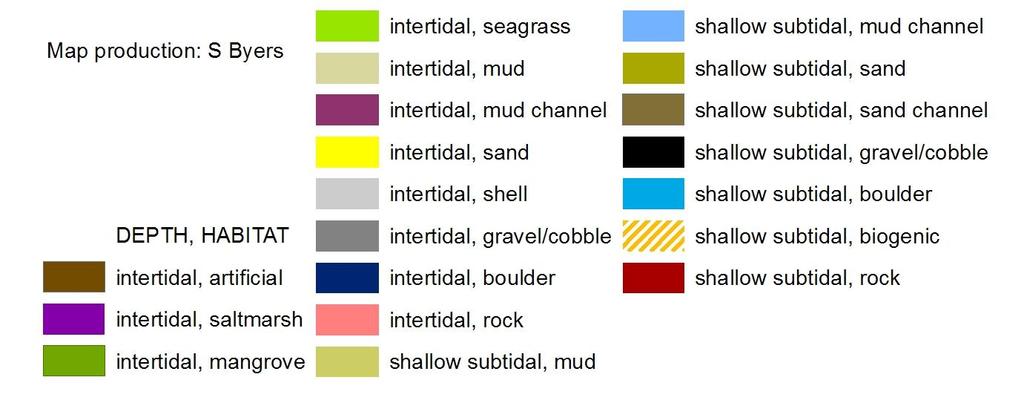
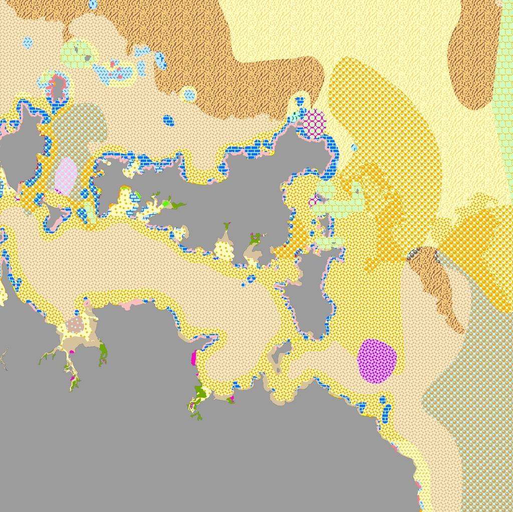
23 Map by Stacy Byers


24 Sidescan sonar Vince Kerr and Roger Grace

25 Sidescan sonar of northern area of Waiheke Island by Vince Kerr and Roger Grace


26 Aerial Photo: Auckland Council Sidescan Vince Kerr and Roger Grace

27 Mapping inshore habitats from sidescan sonar Vince Kerr and Roger Grace


28 Ground truth: side scan sonar Survey for DOC by Roger Grace Noises Islands And reefs north of Whangamata (Roger Grace)
 Colour - Shipping lane 1 survey for LINZ from RNZN, DTM")
 High relief from fare sheets (Stacey Byers) Video")
29 1 km N Multibeam bathymetry off Cuvier Is. (50-140m) Colour - Shipping lane 1 survey for LINZ from RNZN, DTM provided by NIWA) High relief traced from hydrographic charts (Chris Wild) High relief from fare sheets (Stacey Byers) Video drops to 110m Cuvier, Colville Channel

30 Te Matuku Marine Reserve Intertidal habitat map from aerial photo Community and school cockle monitoring Sediment & macrofauna sample points Towed video night surveys of fishes and benthos Seabed types from NIWA QTC single beam sonar Waikato Uni sidescan and multibeam NIWA and LINZ multibeam
Marine habitat map of Northland: Mangawhai to Ahipara
 Marine habitat map of Northland: Mangawhai to Ahipara Version 1 April 2009 Vince Kerr Published by Department of Conservation P.O. Box 842 Whangarei 0140, New Zealand This report was prepared by Vince
Significant Ecological Marine Area Assessment Sheet
 Significant Ecological arine Area Assessment Sheet Name: Eastern Bay of Island Biogenic Soft Sediment Complex Summary: The semi-sheltered areas between the central islands of the Eastern Bay of Islands
National Marine Sanctuary Program
 National Marine Sanctuary Program NMSP/USGS Joint Seabed Mapping Initiative: September 2004 AA National Ocean Service National Marine Sanctuaries Interim Report September 2004 Background: Since 2002,
Intertidal shellfish monitoring in the northern North Island region,
 Intertidal shellfish monitoring in the northern North Island region, 2014 15 New Zealand Fisheries Assessment Report 2015/59 K. Berkenbusch P. Neubauer ISSN 1179-6480 (online) ISBN 978-1-77665-063-7 (online)
FINMARINET: Inventories and Planning for the Marine Natura 2000 Network in Finland. A.2 Geological inventories of the seafloor Final Report
 LIFE07 NAT/FIN/000151 FINMARINET: Inventories and Planning for the Marine Natura 2000 Network in Finland A.2 Geological inventories of the seafloor Final Report Geological Survey of Finland, GTK 1. Introduction
Using remote-sensed data for quantitative shallow water habitat mapping in New Zealand
 Using remote-sensed data for quantitative shallow water habitat mapping in New Zealand Friday 24 February 2012 Geoffroy Lamarche National Institute of Water and Atmospheric Research Wellington with substantial
Confidence Assessment Scoring System
 Confidence Assessment Scoring System Confidence field Confidence group Confidence question Comments Remote sensing data collection RemoteTechnique Were the techniques used appropriate for the ground type?
Aim and objectives Components of vulnerability National Coastal Vulnerability Assessment 2
 ASSESSING THE UTILITY OF GEOMORPHIC SENSITIVITY MAPPING ON THE ILLAWARRA COAST Pamela Abuodha, Christina Baker, Chris Sharples, Darren Skene and Colin Woodroffe Geoquest Research Centre, University of
Coastal and Marine Ecological Classification Standard (CMECS)
") Coastal and Marine Ecological Classification Standard (CMECS) Kathy Goodin, NatureServe EMECS, August 2011 Baltimore, MD 1 Outline Objectives & Process Classification Content Questions 2 Objectives Develop
Coastal and Marine Ecological Classification Standard (CMECS) Kathy Goodin, NatureServe EMECS, August 2011 Baltimore, MD 1 Outline Objectives & Process Classification Content Questions 2 Objectives Develop
The Problem. Which ecosystems are the most sensitive? Where will ecosystems be migrating? Where will investments be overwhelmed?
 BC Parks BC Parks is responsible for the designation, management and conservation of a system of ecological reserves, provincial parks and recreation areas located throughout the province. British Columbia
Intertidal shellfish monitoring in the northern North Island region,
 Intertidal shellfish monitoring in the northern North Island region, 2013 14 New Zealand Fisheries Assessment Report 2015/15 K. Berkenbusch E. Abraham P. Neubauer ISSN 1179-5532 (online) ISBN 978-0-477-10560-6
Modeling habitat suitability for the European green crab using the ShoreZone mapping system
 Modeling habitat suitability for the European green crab using the ShoreZone mapping system Jodi N. Harney, Ph.D. and John R. Harper, Ph.D. Coastal and Ocean Resources Inc. Mary Morris, R.P. Bio. Archipelago
Geophysical Site Surveys
 Geophysical Site Surveys Simon Oakley Geoscience Team Leader Fugro Survey Limited 16/04/2014 Contents Menu Introduction Section 1 - Geophysical Site Surveys - Seabed Bathymetry - Shallow Geology - Seabed
Crustose algae communities on Baltic infralittoral rock and mixed substrata
 European Red List of Habitats Marine: Baltic Habitat Group Crustose algae communities on Baltic infralittoral rock and mixed substrata Summary This benthic habitat is present throughout the Baltic where
ARE YOU READY TO THINK? Look at the first slide THINK PAIR SHARE!
 ARE YOU READY TO THINK? Look at the first slide THINK PAIR SHARE! WHAT PROMINENT FEATURE CAN YOU IDENTIFY IN THIS PICTURE? What do you think the different colors represent? Who might find such a picture
Create your own map for tidepooling, beach field trips, boating, camping, kayaking, fishing, and exploring the beaches in Southcentral Alaska.
 Create your own map for tidepooling, beach field trips, boating, camping, kayaking, fishing, and exploring the beaches in Southcentral Alaska. Here s an opportunity to download and customize your own free
Carte des peuplements benthiques des substrats meubles de la baie de Saint-Brieuc (Source Thouzeau G., Hamon D., 1992) - Echelle 1/ Score sheet
 - Echelle 1/ Score sheet") 16/07/2010 Carte des peuplements benthiques des substrats meubles de la baie de Saint-Brieuc (Source Thouzeau G., Hamon D., 1992) - Echelle 1/100000 sheet sensing? How good is the ground-truthing? How
16/07/2010 Carte des peuplements benthiques des substrats meubles de la baie de Saint-Brieuc (Source Thouzeau G., Hamon D., 1992) - Echelle 1/100000 sheet sensing? How good is the ground-truthing? How
Introduction to Acoustic Remote Sensing and Seafloor Mapping (AE4-E13) May 19, 2010
 May 19, 2010") Introduction to Acoustic Remote Sensing and Seafloor Mapping (AE4-E13) May 19, 2010 1 Delft Vermelding Institute onderdeel of Earth organisatie Observation and Space Systems Why Acoustic Remote Sensing?
Introduction to Acoustic Remote Sensing and Seafloor Mapping (AE4-E13) May 19, 2010 1 Delft Vermelding Institute onderdeel of Earth organisatie Observation and Space Systems Why Acoustic Remote Sensing?
Multiple methods, maps, and management applications: purpose made maps in support of Ocean Management. Craig J. Brown McGregor GeoScience Ltd.
 Multiple methods, maps, and management applications: purpose made maps in support of Ocean Management Craig J. Brown McGregor GeoScience Ltd. International workshop on seabed mapping methods and technology,
Physiography Ocean Provinces p. 1 Dimensions p. 1 Physiographic Provinces p. 2 Continental Margin Province p. 2 Deep-Ocean Basin Province p.
 Physiography Ocean Provinces p. 1 Dimensions p. 1 Physiographic Provinces p. 2 Continental Margin Province p. 2 Deep-Ocean Basin Province p. 2 Mid-Ocean Ridge Province p. 3 Benthic and Pelagic Provinces
BIOLOGICAL OCEANOGRAPHY
 BIOLOGICAL OCEANOGRAPHY AN INTRODUCTION 0 ^ J ty - y\ 2 S CAROL M. LALLI and TIMOTHY R. PARSONS University of British Columbia, Vancouver, Canada PERGAMON PRESS OXFORD NEW YORK SEOUL TOKYO ABOUT THIS VOLUME
Benthic habitat mapping: a synopsis of methodologies and approaches. Dr. Craig Brown University of Ulster
 Benthic habitat mapping: a synopsis of methodologies and approaches Dr. Craig Brown University of Ulster Technological advances in remote sensing Insitu sampling Improving technology Single beam acoustics/video
Directed Reading. Section: The Water Planet. surface is called the a. Earth s ocean. b. Pacific Ocean. c. salt-water ocean. d. global ocean.
 Skills Worksheet Directed Reading Section: The Water Planet 1. The body of salt water covering nearly three-quarters of the Earth s surface is called the a. Earth s ocean. b. Pacific Ocean. c. salt-water
Marine ecosystem mapping at the Prince Edward Islands
 Marine ecosystem mapping at the Prince Edward Islands Biodiversity Planning Forum NBA special session June 2018 R Adams, C von der Meden, A Dayaram, K Sink, A Lombard, A Bosman, M Dopolo, F Fourie, L Harris,
Reading Material. See class website. Sediments, from Oceanography M.G. Gross, Prentice-Hall
 Reading Material See class website Sediments, from Oceanography M.G. Gross, Prentice-Hall Materials filling ocean basins Dissolved chemicals especially from rivers and mid-ocean ridges (volcanic eruptions)
Lecture Outlines PowerPoint. Chapter 13 Earth Science 11e Tarbuck/Lutgens
 Lecture Outlines PowerPoint Chapter 13 Earth Science 11e Tarbuck/Lutgens 2006 Pearson Prentice Hall This work is protected by United States copyright laws and is provided solely for the use of instructors
Kyle Griebel NRS 509 Dr. August & Dr. Wang GIS and remote sensing in Seafloor mapping
 GIS and remote sensing in Seafloor mapping Introduction to seafloor mapping Seafloor maps have a wide variety of uses for scientists and coastal planning needs. Some of these uses include biological assessment
Coastal Zone Mapping and Imaging Lidar (CZMIL)
") Coastal Zone Mapping (CZMIL) Shallow Survey 2012 Wellington, New Zealand Christopher L. Macon U.S. Army Corps of Engineers, Mobile District Joint Airborne Lidar Bathymetry Technical Center of expertise
Coastal Zone Mapping (CZMIL) Shallow Survey 2012 Wellington, New Zealand Christopher L. Macon U.S. Army Corps of Engineers, Mobile District Joint Airborne Lidar Bathymetry Technical Center of expertise
Coastal and Marine Ecological Classification Standard (CMECS)
") Coastal and Marine Ecological Classification Standard (CMECS) Mark Finkbeiner NOAA Coastal Services Center Presented at the International Workshop on Seabed Mapping Methods and Technology 18 October 2012
Coastal and Marine Ecological Classification Standard (CMECS) Mark Finkbeiner NOAA Coastal Services Center Presented at the International Workshop on Seabed Mapping Methods and Technology 18 October 2012
The Application of CHRIS Data to the Multi-temporal & Multi-angular Study of Near-shore Marine Bathymetry
 The Application of CHRIS Data to the Multi-temporal & Multi-angular Study of Near-shore Marine Bathymetry PhD/Postgrad students: Libby Boak Stacy Mitchell AJ Lau Indrie Miller School of Biological, Earth,
Alexandra Carvalho, Ph.D., GISP Kathy Fitzpatrick, P.E.
 Coastal Data Organization for Project Management and Coastal Planning Martin County, Florida Alexandra Carvalho, Ph.D., GISP Kathy Fitzpatrick, P.E. Outline County Coastal Programs Coastal Geodatabase
Systematic approaches to marine spatial planning
 Systematic approaches to marine spatial planning Dan Breen Sean Cooper Marine Conservation Team Aquatic and Threats Research and Development New Zealand Department of Conservation Survey of 22 managers
Outline. - Background of coastal and marine conservation - Species distribution modeling (SDM) - Reserve selection analysis. - Results & discussion
 - Reserve selection analysis. - Results & discussion") Application of GIS for data preparation and modeling for coastal and marine conservation planning in Madagascar Rija Rajaonson Technical Assistant, REBIOMA Wildlife Conservation Society Madagascar Outline
Application of GIS for data preparation and modeling for coastal and marine conservation planning in Madagascar Rija Rajaonson Technical Assistant, REBIOMA Wildlife Conservation Society Madagascar Outline
Environmental impact assessment study of the new offshore dumping sites for Šventoji port in Lithuania
 Environmental impact assessment study of the new offshore dumping sites for Šventoji port in Lithuania Introduction Summary In 2003 Lithuanian Ministry of Transport initiated the preparation of feasibility
ssessments Ecoregional Assessment
 Standard 7: Select terrestrial, freshwater and marine conservation targets/biodiversity elements/features across multiple biological and spatial scales. Case Study: Shoreline Habitat Classification for
Treasure Coast Science Scope and Sequence
 Course: Marine Science I Honors Course Code: 2002510 Quarter: 3 Topic(s) of Study: Marine Organisms and Ecosystems Bodies of Knowledge: Nature of Science and Life Science Standard(s): 1: The Practice of
SW Florida Escarpment Mapping Area
 Overview NOAA s Okeanos Explorer (EX) Program plans to conduct systematic mapping and telepresence-enabled ROV explorations in the Gulf of Mexico during Spring 2014. In 2011, the EX conducted mapping operations
Relatively little hard substrate occurs naturally in the
 CHAPTER FIVE Rock Habitats Relatively little hard substrate occurs naturally in the estuary, owing mainly to the vast quantities of fine sediment that have been deposited by the rivers. Rock habitat is
Rock Boulder RockSand 1 RockSand 2 RockSand 3 Sand
 Figure 15. Histogram comparison of ROV observed primary substrates determined from 33,605 dgps positions to RoxAnn seabed classification. Pie charts represent the percentage of ROV modified primary substrate
Marine Spatial Planning: A Tool for Implementing Ecosystem-Based Management
 Marine Spatial Planning: A Tool for Implementing Ecosystem-Based Management Steven Murawski, Ph.D., Ecosystem Goal Team Lead National Oceanic and Atmospheric Administration NOAA November 16, 2009 1 To
Food for thoughts. Jon Davies MESH Project Coordinator
 Food for thoughts Jon Davies MESH Project Coordinator You are not alone.. There is someone out there.. Habmap UKSeaMap MESH Why is he here? Introduce the MESH Project, give a brief overview of other marine
BEFORE THE ENVIRONMENTAL PROTECTION AUTHORITY AT WELLINGTON
 BEFORE THE ENVIRONMENTAL PROTECTION AUTHORITY AT WELLINGTON IN THE MATTER of the Exclusive Economic Zone and Continental Shelf (Environmental Effects) Act 2012 (EEZ Act) AND IN THE MATTER BETWEEN AND AND
The Marine Environment
 The Marine Environment SECTION 16.1 Shoreline Features In your textbook, read about erosional landforms, beaches, estuaries, longshore currents, and rip currents. For each statement below, write true or
are unconsolidated particulate materials that either precipitate from or are deposited by a fluid (e.g., water, wind);
;") Sediments... are unconsolidated particulate materials that either precipitate from or are deposited by a fluid (e.g., water, wind); provide information about the past depositional environments and climatic
Sediments... are unconsolidated particulate materials that either precipitate from or are deposited by a fluid (e.g., water, wind); provide information about the past depositional environments and climatic
 http://www.neic.cr.usgs.gov/neis/pands/global.html Global Seismicity and World Cities This map displays the worldwide hazard to cities by large earthquakes. When earthquakes occur near cities, the potential
Ecological mapping using satellite imagery: an Abu Dhabi case study Middle East Geospatial Forum 16 th February 2015
 Ecological mapping using satellite imagery: an Abu Dhabi case study Middle East Geospatial Forum 16 th February 2015 Richard Flemmings rf@proteusgeo.com About Proteus Formed in UAE 2011 We specialise in
Biogeographic Approach to Coastal Assessments & Spatial Planning
 NOAA s Biogeographic Approach to Coastal Assessments & Spatial Planning Mark E. Monaco Mark.Monaco@noaa.gov Center for Coastal Monitoring and Assessment http://ccma.nos.noaa.gov/about/biogeography Biogeography
Cambridge International Examinations Cambridge International Advanced Subsidiary and Advanced Level
 Cambridge International Examinations Cambridge International Advanced Subsidiary and Advanced Level *0627433796* MARINE SCIENCE 9693/01 Paper 1 AS Structured Questions October/November 2016 1 hour 30 minutes
Bio 20 Marine Biology Exam 4 Outline
 The Intertidal Zone (Littoral Zone) Bio 20 Marine Biology Exam 4 Outline Between the Tides (Chapter 11) 2 main types of intertidal zones I. Rocky Shore Communities A. Problems that rocky intertidal organisms
Sea-level Rise on Cape Cod: How Vulnerable Are We? Rob Thieler U.S. Geological Survey Woods Hole, MA
 Sea-level Rise on Cape Cod: How Vulnerable Are We? Rob Thieler U.S. Geological Survey Woods Hole, MA Outline Sea-level and coastal processes Past sea-level change Predictions for the future Coastal responses
Mapping of marine habitats in shallow coastal areas in Denmark
 6 th Workshop Seabed Acoustics, Rostock, November 14/15, 2013 P11-1 Mapping of marine habitats in shallow coastal areas in Denmark Dr. Zyad Al-Hamdani Geological Survey of Denmark and Greenland - GEUS
The Arctic - A New Frontier The geological, environmental and engineering challenges for submarine telecommunication cables
 The Arctic - A New Frontier The geological, environmental and engineering challenges for submarine telecommunication cables Ryan Wopschall 5 September 2013 Oceanology International China, Shanghai Fugro
Using seascapes to help predict Australia s benthic marine habitat diversity in the development of a national system of marine protected areas
 Using seascapes to help predict Australia s benthic marine habitat diversity in the development of a national system of marine protected areas A.D. Heap 1, T. Whiteway 1, V. Lucieer 2, S. Nichol 1 1. Geoscience
PRINCIPLE OF OCEANOGRAPHY PBBT101 UNIT-1 INTRODUCTION OF OCEANIC ENVIRONMENT. PART-A (2 Marks)
") PRINCIPLE OF OCEANOGRAPHY PBBT101 UNIT-1 INTRODUCTION OF OCEANIC ENVIRONMENT 1. Define marine ecosystem. 2. What is geography? 3. Give two Oceanic zones 4. What is sea? 5. Define oceanography? 6. Enlist
PRINCIPLE OF OCEANOGRAPHY PBBT101 UNIT-1 INTRODUCTION OF OCEANIC ENVIRONMENT 1. Define marine ecosystem. 2. What is geography? 3. Give two Oceanic zones 4. What is sea? 5. Define oceanography? 6. Enlist
Marine Geomorphology as a Determinant for Essential Life Habitat III
 Marine Geomorphology as a Determinant for Essential Life Habitat III marinecoastalgis.net/aag08 10:10 Dawn Wright, Oregon 10:30 Will McClintock, California 10:50 Daniel Sampson, Massachusetts 11:10 Gary
by B.A. Foster THE EFFECT OF ASPECT ON POPULATION COMPOSITION
 TANE (1966) 12 : 37-44 37 THE EFFECTS OF WAVE EXPOSURE AND ASPECT ON THE VERTICAL SHORE DISTRIBUTION AND POPULATION COMPOSITION OF MELARHAPHA OLIVERI. by B.A. Foster INTRODUCTION The periwinkle Melarhapha
From seafloor geomorphology to predictive habitat mapping: progress in applications of biophysical data to ocean management.
 From seafloor geomorphology to predictive habitat mapping: progress in applications of biophysical data to ocean management. Peter T. Harris Geoscience Australia, Canberra ACT, Australia Currently seconded
NIWA Client Report: WLG July 2004 NIWA Project: DOC04403
 BENTHIC HABITATS OFF KAIKOURA - Physical characteristics from side-scan sonar and depth imagery NIWA Client Report: WLG2004-50 July 2004 NIWA Project: DOC04403 BENTHIC HABITATS OFF KAIKOURA - Physical
Map 39 SECTION E: OUTSTANDING COASTAL NATURAL CHARACTER. Legend. Outstanding Coastal Natural Character Areas. Extent of Coastal Environment
 8 289 Legend 1 2 2 3 Extent of Coastal Environment Outstanding Coastal Natural Character Areas 5 Tapuaetahi Bay and Coastline Adjacent Outstanding Coastal Natural Character Areas 4 7 5 6 SECTION E: OUTSTANDING
Marine Sediments EPSS15 Spring 2017 Lab 4
 Marine Sediments EPSS15 Spring 2017 Lab 4 Why Sediments? Record of Earth s history - Tectonic plate movement - Past changes in climate - Ancient ocean circulation currents - Cataclysmic events 1 Classification
12/11/2013& egm502 seafloor mapping
 egm502 seafloor mapping lecture 13 multi-beam echo-sounders The majority of the current charts of the ocean floors have been produced from single beam echo-sounder data. Even though these data have been
Dynamic preservation of the coastline
 Dynamic preservation of the coastline Content Introduction The Dutch coastal defence by dynamic processes Data collection Management of the sand resources Growing importance of marine sand and gravel resources
Earth / Environmental Science. Ch. 14 THE OCEAN FLOOR
 Earth / Environmental Science Ch. 14 THE OCEAN FLOOR The Blue Planet Nearly 70% of the Earth s surface is covered by the global ocean It was not until the 1800s that the ocean became an important focus
Picture: Nigel Keeley. SustainAqua. Sustainable aquaculture in the North identifying thresholds, indicators and tools for future growth
 Picture: Nigel Keeley SustainAqua Sustainable aquaculture in the North identifying thresholds, indicators and tools for future growth 4 årigt forskningsråds prosjekt Norway International Raymond Bannister
Offshore Video Survey and Oceanographic Analysis: Georges Bank to the Chesapeake project
 Non-Technical Synopsis of the Offshore Video Survey and Oceanographic Analysis: Georges Bank to the Chesapeake project Executive Summary Dave Bethoney Kristin Kleisner Mark Anderson Changsheng Chen Bradley
SEABED CLASSIFICATION FROM MULTIBEAM ECHOSOUNDER BACKSCATTER DATA USING WAVELET TRANSFORMATION AND NEURAL NETWORK APPROACH
 SEABED CLASSIFICATION FROM MULTIBEAM ECHOSOUNDER BACKSCATTER DATA USING WAVELET TRANSFORMATION AND NEURAL NETWORK APPROACH Jaroslaw Tegowski a,b, Jaroslaw Nowak a, Mateusz Moskalik c, Kazimierz Szefler
Ngā Motu Marine Reserve Society. List of Questions for Expert Witnesses. Trans-Tasman Resources Limited Sand Mining Application 2016
 Ngā Motu Marine Reserve Society List of Questions for Expert Witnesses Trans-Tasman Resources Limited Sand Mining Application 2016 The questions for the witnesses are provided below in bold blue text.
SEABED MAPPING. Selsey to Eastoke TR 65
 SEABED MAPPING Selsey to Eastoke TR 65 Contents Channel Coastal Observatory National Oceanography Centre European Way Southampton SO14 3ZH Tel: +44 (0)23 8059 8472 e-mail: cco@channelcoast.org Website:
Auckland Council District Plan Hauraki Gulf Islands Section Operative 2013 Proposed plan modification no. 1: Plan Change
 Page 1 Auckland Council District Plan Hauraki Gulf Islands Section Operative 2013 Proposed plan modification no. 1: Plan Change Date of public notification: 31 May 2013 Closing date for submission: 1 July
Current and Future Technology Applications for Coastal Zone Management. Bruce K. Carlisle, Acting Director Office of Coastal Zone Management
 Current and Future Technology Applications for Coastal Zone Management Bruce K. Carlisle, Acting Director Office of Coastal Zone Management The Massachusetts Coastal Zone Management Program Approved in
Sediment classification from multibeam backscatter images using simple histogram analysis
 Sediment classification from multibeam backscatter images using simple histogram analysis Rozaimi Che Hasan 1,2, Mohd Razali Mahmud 3 and Shahrin Amizul Shamsudin 1 1 UTM Razak School of Engineering and
Intertidal shellfish monitoring in the northern North Island region,
 Intertidal shellfish monitoring in the northern North Island region, 2015 16 New Zealand Fisheries Assessment Report 2016/49 K. Berkenbusch P. Neubauer ISSN 1179-5352 (online) ISBN 978-1-77665-365-2 (online)
Evolution and Life in the Ocean
 Characteristics of All Living Things Contain matter in a highly organized state Capture, store and transmit energy; all organisms require energy Capable of reproduction Change through time and adapt to
Map shows 3 main features of ocean floor
 Map shows 3 main features of ocean floor 2017 Pearson Education, Inc. Chapter 3 Marine Provinces 2017 Pearson Education, Inc. 1 Chapter 3 Overview The study of bathymetry determines ocean depths and ocean
Cowichan Estuary Habitat Mapping and Oyster Population Assessment. Cowichan Stewardship Round Table
 Cowichan Estuary Habitat Mapping and Oyster Population Assessment Presentation at Cowichan Stewardship Round Table June 21, 2018 By Dr. Goetz Schuerholz 1 More than 8000 drone photos taken stitched together
A lithological map created from multibeam backscatter data in challenging circumstances: the Lower Sea Scheldt estuary
 A lithological map created from multibeam backscatter data in challenging circumstances: the Lower Sea Scheldt estuary Mieke Mathys*, Marc Sas*, Frederik Roose** HYDRO12, Rotterdam, 15/11/2012 *International
NOAA/University of New Hampshire Joint Hydrographic Center & Center for Coastal and Ocean Mapping. MAPPS Summer Conference July 23, 2013
 NOAA/University of New Hampshire Joint Hydrographic Center & Center for Coastal and Ocean Mapping MAPPS Summer Conference July 23, 2013 07/23/2013 2 07/23/2013 3 Center Goals To be a world leader in the
GG710 Remote Sensing in Submarine Environments Sidescan Sonar
 GG710 Remote Sensing in Submarine Environments Sidescan Sonar Harold Edgerton, a professor of electrical engineering at the Massachusetts Institute of Technology, developed sidescan sonar technology for
Bathymetry Measures the vertical distance from the ocean surface to mountains, valleys, plains, and other sea floor features
 1 2 3 4 5 6 7 8 9 10 11 CHAPTER 3 Marine Provinces Chapter Overview The study of bathymetry determines ocean depths and ocean floor topography. Echo sounding and satellites are efficient bathymetric tools.
Subtidal permanently flooded with tidal water. Irregularly exposed surface exposed by tides less often than daily
 Types of Wetlands Tidal Systems COASTAL WETLAND ECOSYSTEMS Tidal Salt Marshes Tidal Freshwater Marshes Mangrove Wetlands Tidal Estuarine Wetland 1 Definition and Formation of Estuaries u Estuary : partially
Types of Wetlands. Tidal Systems
 Types of Wetlands Tidal Systems 1 COASTAL WETLAND ECOSYSTEMS Tidal Salt Marshes Tidal Freshwater Marshes Mangrove Wetlands 2 Tidal Estuarine Wetland 3 Definition and Formation of Estuaries Estuary: : partially
Quantitative experimental comparison of single-beam, sidescan, and multibeam benthic habitat maps
 1766 Quantitative experimental comparison of single-beam, sidescan, and multibeam benthic habitat maps Alexandre C. G. Schimel, Terry R. Healy, David Johnson, and Dirk Immenga Schimel, A. C. G., Healy,
Foundations of Earth Science, 6e Lutgens, Tarbuck, & Tasa
 Foundations of Earth Science, 6e Lutgens, Tarbuck, & Tasa Oceans: The Last Frontier Foundations, 6e - Chapter 9 Stan Hatfield Southwestern Illinois College The vast world ocean Earth is often referred
The Marine Environment
 The Marine Environment SECTION 16.1 Shoreline Features In your textbook, read about erosional landforms, beaches, estuaries, longshore currents, and rip currents. For each statement below, write or. 1.
RED LIST OF EUROPEAN HABITATS. Marine Results Presentation 24 th May, 2016
 RED LIST OF EUROPEAN HABITATS Marine Results Presentation 24 th May, 2016 Geographical scope of the project Habitat Typology One typology for marine and terrestrial At the same time... revision of EUNIS
2.2.7 Backbarrier flats
 FIGURE 24. VERTICAL PHOTOGRAPH SHOWING THE DEVELOPMENT OF SMALL PARABOLIC DUNES FROM BLOWOUTS IN A LARGE RELICT FOREDUNE NORTHWEST OF HUNTER'S CREEK. PHOTOGRAPH COURTESY OF CAR'T'ER HOLT HARVEY FORESTS
June 2018 Sediments and Dredging at GBR Ports
 June 2018 Sediments and Dredging at GBR Ports Reef 2050 Long Term Sustainability Plan The Great Barrier Reef is over 2000 km long and covers an area of approximately 350,000 square kilometres. It is a
Mapping intertidal sediment distributions using the RoxAnn System, Dornoch Firth, NE Scotland
 Mapping intertidal sediment distributions using the RoxAnn System, Dornoch Firth, NE Scotland J. HULL & R. NUNNY Ambios Environmental Consultants Ltd, The Ferns, Kilkenny Ave, Taunton, Somerset TA2 7P
An overview of the use of acoustic data for geology and habitat mapping in MAREANO
 An overview of the use of acoustic data for geology and habitat mapping in MAREANO Margaret Dolan, Valerie Bellec, Sigrid Elvenes, Reidulv Bøe, Terje Thorsnes, Shyam Chand, Leif Rise, Monica Winsborrow
of the Resource Management Act 1991 ("Act") (ENV-2013-AKL )
 (ENV-2013-AKL )") BEFORE THE ENVIRONMENT COURT IN THE MATTER of the Resource Management Act 1991 ("Act") AND IN THE MATTER of a Notice of Motion under section 87G of the Act requesting the granting of resource consents
BEFORE THE ENVIRONMENT COURT IN THE MATTER of the Resource Management Act 1991 ("Act") AND IN THE MATTER of a Notice of Motion under section 87G of the Act requesting the granting of resource consents
Introduction: The Gulf of Mexico Alliance. The Gulf GAME project MERMAid and PHINS Results & Conclusions What s next? Examples
 AAG Las Vegas March 25, 2009 Introduction: Ocean governance and Ecosystem-Based Management The Gulf of Mexico Alliance Habitat Identification and Characterization The Gulf GAME project MERMAid and PHINS
SHORELINE MANAGEMENT PLAN FOR OWEN ANCHORAGE AND COCKBURN SOUND SHORELINE MONITORING PLAN
 SHORELINE MANAGEMENT PLAN FOR OWEN ANCHORAGE AND COCKBURN SOUND SHORELINE MONITORING PLAN CHAPTER EIGHT OF DOCUMENT: LONG-TERM SHELLSAND DREDGING, OWEN ANCHORAGE ENVIRONMENTAL MANAGEMENT PROGRAMME JUNE
Chapter Overview. Bathymetry. Measuring Bathymetry. Measuring Bathymetry
 CHAPTER 3 Marine Provinces Chapter Overview The study of bathymetry determines ocean depths and ocean floor topography. Echo sounding and satellites are efficient bathymetric tools. Most ocean floor features
Characterization of the Nigerian Shoreline using Publicly-Available Satellite Imagery
 University of New Hampshire University of New Hampshire Scholars' Repository Center for Coastal and Ocean Mapping Center for Coastal and Ocean Mapping 1-2014 Characterization of the Nigerian Shoreline
A Detailed First Pass coastal hazard assessment for a long complex coast: Kingborough LGA, Tasmania
 A Detailed First Pass coastal hazard assessment for a long complex coast: Kingborough LGA, Tasmania Chris Sharples & Paul Donaldson University of Tasmania September 2012 Kingborough LGA, south-eastern
Diameter of objects moved (mm)
") PRACTICE SAC on DATA TRANSFORMATIONS Rivers and streams carry small solid particles of rock downhill.solid particles are classified according to their mean diameter from smallest to largest as clay, silt,
PRACTICE SAC on DATA TRANSFORMATIONS Rivers and streams carry small solid particles of rock downhill.solid particles are classified according to their mean diameter from smallest to largest as clay, silt,
The Systems Approach. Alun Williams, ABPmer
 The Systems Approach Alun Williams, ABPmer Overview What is A Systems Approach? Behavioural / Qualitative Modelling? System Definition / Mapping (Behavioural Statements Objective) What is a Systems Approach?
GIS USE IN THE STUDY OF ESTUARINE SOILS AND SEDIMENTS Margot K. Payne NRS 509 November 30, 2005
 GIS USE IN THE STUDY OF ESTUARINE SOILS AND SEDIMENTS Margot K. Payne NRS 509 November 30, 2005 Throughout the world, estuaries are not only some of the most ecologically productive environments, but are
SEABED MORPHOLOGY OFF SOUTHERN LONG ISLAND: STUDIES OF ARTIFICIAL REEFS AND IMPLICATIONS FOR WIND FARMS. Juliet Kinney & Roger D.
 SEABED MORPHOLOGY OFF SOUTHERN LONG ISLAND: STUDIES OF ARTIFICIAL REEFS AND IMPLICATIONS FOR WIND FARMS Juliet Kinney & Roger D. Flood Marine Sciences Research Center, Stony Brook University Stony Brook,
The Ocean Floor Earth Science, 13e Chapter 13
 The Ocean Floor Earth Science, 13e Chapter 13 Stanley C. Hatfield Southwestern Illinois College The vast world ocean Earth is often referred to as the blue planet Seventy-one percent of Earth s surface