12/11/2013& egm502 seafloor mapping
|
|
|
- Georgina Lee
- 5 years ago
- Views:
Transcription


1 egm502 seafloor mapping lecture 13 multi-beam echo-sounders The majority of the current charts of the ocean floors have been produced from single beam echo-sounder data. Even though these data have been acquired on a continuous basis for at least 50 years, large tracts of the seafloor remain unmapped. One of the reasons for this is that survey lines for conventional bathymetric surveys are often spaced 100's to 1000's of kilometres apart. This leaves us in the bizarre situation that more is known about the surface of many of the planets in the solar system than is know about Earth. reading lurton, 2010, Section 8.3 Geological Survey of Norway, 2004 The MBES is an extension of the SBES. Instead of transmitting and receiving a single vertical beam, the MBES transmits and receives a fan of beams with small beam angles (typically 1 or 2 ) across the ship axis. Typically achieving 200 or more depth measurements, imaging a wide swath up to 150 (7.5 times water depth). Now the primary tool for seafloor mapping. Two types of swath systems are commonly employed for bathymetric mapping multi-beam echo-sounders (beamforming) and interferometric sonars (also termed bathymetric sidescan sonar). Each of these systems has its own advantages and disadvantages. To put it simply, MBES systems offer higher-resolution bathymetric data with low-order backscatter data as a by-product, whereas interferometric systems offer lower-order bathymetric data and true side-scan. The more sophisticated MBES can simultaneously acquire depth and backscatter data for each point insonified on the seafloor 1&
 is a signal processing technique used in sensor arrays for directional signal transmission or reception.")

2 Beamforming Artificially steers the array directivity pattern. Beamforming (sometimes refereed to as spatial filtering) is a signal processing technique used in sensor arrays for directional signal transmission or reception. This is achieved by combining elements in a phased array in such a way that signals at particular angles experience constructive interference while others experience destructive interference. Beamforming can be used at both the transmitting and receiving ends in order to achieve spatial selectivity. In simple terms..for a sonar to transmit a sharp pulse of underwater sound towards the seafloor, simply transmitting that sharp pulse from every projector in an array simultaneously fails because the near-field is insonified before the far-field. The beamforming technique solves this by sending the pulse from each projector at slightly different times (the central projector last), so that every pulse hits the seafloor at exactly the same time, producing the effect of a single strong pulse from a single powerful projector. Interferometric sonar (Gostnell, 2010) IFMS systems are not beam-forming, but measure depths at precise locations on the seafloor via the use of exactly spaced phase differencing transducer elements which measure the phase offsets of acoustic returns. The phase offset is used to calculate the angle ( ) from which the return was received. The angle, in combination with range based on two way travel time, is used to calculate the position of the seafloor and objects upon it relative to the instrument. This provides accurate bathymetric data co-located with SSS imagery which can be used to create either side-scan sonar (SSS) imagery, bathymetry, or imagery with associated depths. MBES have varied applications. 3 main categories: Deep water systems Typically 12 khz for deep ocean and 30 khz for continental slopes Designed for regional mapping Large arrays, limited t large deep-sea vessels Shallow-water systems Typically khz Designed for mapping continental shelves Best suited to hydrography High-resolution systems Typically khz Designed for high-resolution imaging Hydrography, shipwreck location, inspection of underwater structures Small sizes means suitable for deployment on ROVs and AUVs 2&


3 ADUS, 2005 ADUS Transmission and reception arrays Narrow horizontal sector, narrow beam angles insonify thin strip acrosstrack Wide vertical sector, broad angular sector, large across-track sector Most commonly employed reception arrays: Horizontal linear V-shaped U-shaped ADUS Simplest configuration, limits useful swath width to Unstable hull mount. & Two linear arrays, inclined (aka dualhead). Allows large swaths with moderate beam-steering. & Circular section array, enables simple beamforming. & 3&


 w = 3.")
4 Resolution considerations Across Track Along Track Across track resolution controlled by: No. of beams, angular sector, beamwidth and beam spacing. Along track resolution controlled by: Vessel speed and pulse rate. Beamwidth and data resolution Same seafloor imaged with 2 different systems Angular Sector (α) (α)# d MBES are often described by their achievable angular sector (α), e.g. 120 o α" w If α = 120, then w = 2d tan(120/2) w = 3.46d The swath width of the 120 o system therefore approximates 3.5 times the water depth 4&


 survey are defined by IHO in")

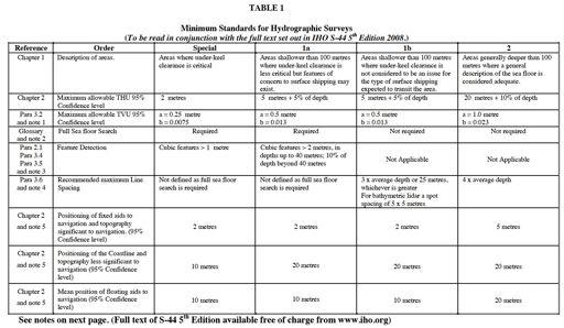
5 HYDROGRAPHIC SURVEYING (IHO, 2005, 2011) Survey Specifications Name Craig Dyer Degree BSc Marine Science I graduated with a 2.1 in 2011 and started with Fugro EMU in Southampton. I am now a Senior Hydrographic Surveyor, responsible for the collection and consolidation of high-resolution bathymetric data. To accommodate in a systematic manner different accuracy requirements for areas to be surveyed, four orders of (hydrographic) survey are defined by IHO in publication S-44 5th Edition One of the many surveys we are completing is the UK Civil Hydrography Programme, helping the UKHO and MCA update nautical charts for safe navigation. 5&
6 6&
Acoustic seafloor mapping systems. September 14, 2010
 Acoustic seafloor mapping systems September 14, 010 1 Delft Vermelding Institute onderdeel of Earth organisatie Observation and Space Systems Acoustic seafloor mapping techniques Single-beam echosounder
Introduction to Acoustic Remote Sensing and Seafloor Mapping (AE4-E13) May 19, 2010
 May 19, 2010") Introduction to Acoustic Remote Sensing and Seafloor Mapping (AE4-E13) May 19, 2010 1 Delft Vermelding Institute onderdeel of Earth organisatie Observation and Space Systems Why Acoustic Remote Sensing?
Introduction to Acoustic Remote Sensing and Seafloor Mapping (AE4-E13) May 19, 2010 1 Delft Vermelding Institute onderdeel of Earth organisatie Observation and Space Systems Why Acoustic Remote Sensing?
Smart Survey Approach: Multibeam Echosounder and Integrated Water Column Data as an Added Value for Seep Hunting
 Smart Survey Approach: Multibeam Echosounder and Integrated Water Column Data as an Added Value for Seep Hunting HYDRO 2016 8 November 2016 Marco Filippone Introduction, Multibeam Sonars & water column
Topic: Bathymetric Survey Techniques. (a) Single-beam echo-sounders (SBES) (b) Multi-beam echo-sounders (MBES)
 Single-beam echo-sounders (SBES) (b) Multi-beam echo-sounders (MBES)") Topic: Bathymetric Survey Techniques (a) Single-beam echo-sounders (SBES) (b) Multi-beam echo-sounders (MBES) Bathymetry is the measurement of water depths - bathymetry is the underwater equivalent of
Topic: Bathymetric Survey Techniques (a) Single-beam echo-sounders (SBES) (b) Multi-beam echo-sounders (MBES) Bathymetry is the measurement of water depths - bathymetry is the underwater equivalent of
GG710 Remote Sensing in Submarine Environments Sidescan Sonar
 GG710 Remote Sensing in Submarine Environments Sidescan Sonar Harold Edgerton, a professor of electrical engineering at the Massachusetts Institute of Technology, developed sidescan sonar technology for
National Marine Sanctuary Program
 National Marine Sanctuary Program NMSP/USGS Joint Seabed Mapping Initiative: September 2004 AA National Ocean Service National Marine Sanctuaries Interim Report September 2004 Background: Since 2002,
NEW SEAFLOOR INSTALLATIONS REQUIRE ULTRA-HIGH RESOLUTION SURVEYS
 NEW SEAFLOOR INSTALLATIONS REQUIRE ULTRA-HIGH RESOLUTION SURVEYS Donald Hussong (Fugro Seafloor Surveys, Inc.) dhussong@fugro.com Fugro Seafloor Surveys, Inc., 1100 Dexter Avenue North (Suite 100), Seattle,
Offshore Operations and Project Execution Geophysical Site Surveys
 Offshore Operations and Project Execution Geophysical Site Surveys Chris Almond Senior Geophysicist Fugro Survey Limited 22/04/2015 Presentation Summary: Office-based Personnel Project Awarded Pre Offshore
Storm Response Surveying with Phase- Measuring Bathymetric Sidescan Sonar
 Storm Response Surveying with Phase- Measuring Bathymetric Sidescan Sonar Kevin Jerram and Val Schmidt Center for Coastal and Ocean Mapping Durham, New Hampshire Two sunken subway cars and adjacent bedforms
NOAA/University of New Hampshire Joint Hydrographic Center & Center for Coastal and Ocean Mapping. MAPPS Summer Conference July 23, 2013
 NOAA/University of New Hampshire Joint Hydrographic Center & Center for Coastal and Ocean Mapping MAPPS Summer Conference July 23, 2013 07/23/2013 2 07/23/2013 3 Center Goals To be a world leader in the
Recent developments in multi-beam echo-sounder processing at the Delft
 Recent developments in multi-beam echo-sounder processing at the Delft University of Technology Prof. Dr. Dick G. Simons Acoustic Remote Sensing Group, Faculty of Aerospace Engineering, Delft University
Inspection of Waterfront Facilities Using Vessel-Based Remote Sensing Mitchell, Del Bello, Suarez
 Inspection of Waterfront Facilities Using Vessel-Based Remote Sensing Mitchell, Del Bello, Suarez American Association of Port Authorities Facilities Engineering Conference October 20-22, 2015 Waterfront
Your web browser (Safari 7) is out of date. For more security, comfort and the best experience on this site: Update your browser Ignore
 is out of date. For more security, comfort and the best experience on this site: Update your browser Ignore") Your web browser (Safari 7) is out of date. For more security, comfort and the best experience on this site: Update your browser Ignore BATHYMETRY For the complete encyclopedic entry with media resources,
Your web browser (Safari 7) is out of date. For more security, comfort and the best experience on this site: Update your browser Ignore BATHYMETRY For the complete encyclopedic entry with media resources,
Ultrasonic Measuring System for Deposition of Sediments in Reservoirs
 MECAHITECH 11, vol. 3, year: 011 Ultrasonic Measuring System for Deposition of Sediments in Reservoirs M. Mărgăritescu* 1, A. Moldovanu * 1, P. Boeriu *, A.M.E. Rolea* 1 * 1 National Institute of Research
Essential Question: How are the geological features that exist on land similar to the geological features on the ocean floor?
 Essential Question: How are the geological features that exist on land similar to the geological features on the ocean floor? Geography of the Oceans The world ocean can be divided into four main ocean
GEOPHYSICAL TECHNIQUES FOR MARITIME ARCHAEOLOGICAL SURVEYS. Abstract
 GEOPHYSICAL TECHNIQUES FOR MARITIME ARCHAEOLOGICAL SURVEYS Mark Lawrence, Wessex Archaeology, Salisbury, UK, Ian Oxley, English Heritage, Portsmouth, UK, C. Richard Bates, University of St. Andrews, St.
Future Ocean Floor Mapping: Ocean Stewardship & Initial Industry Contributions. U.S Hydro Galveston, TX March 23, 2017 David Millar - Fugro
 Future Ocean Floor Mapping: Ocean Stewardship & Initial Industry Contributions U.S Hydro 2017 - Galveston, TX March 23, 2017 David Millar - Fugro Presentation Outline The Need for Ocean Mapping GEBCO GEBCO
Name Class Date. The ocean floor has varied and distinct surfaces much like those found on land.
 6 Explore the Seafloor BigIdeas The ocean floor has varied and distinct surfaces much like those found on land. Satellites orbiting Earth, as well as sonar technology, are used to map the seafloor. The
Bathymetry Measures the vertical distance from the ocean surface to mountains, valleys, plains, and other sea floor features
 1 2 3 4 5 6 7 8 9 10 11 CHAPTER 3 Marine Provinces Chapter Overview The study of bathymetry determines ocean depths and ocean floor topography. Echo sounding and satellites are efficient bathymetric tools.
Cruise Report YK10-06
 Cruise Report YK10-06 (R/V Yokosuka) Site Surveys for drilling projects of IODP at the Kumano-nada and the northern Izu-Bonin arc June 13 20, 2010 Center for Deep Earth Exploration (CDEX) Japan Agency
Chapter Overview. Bathymetry. Measuring Bathymetry. Measuring Bathymetry
 CHAPTER 3 Marine Provinces Chapter Overview The study of bathymetry determines ocean depths and ocean floor topography. Echo sounding and satellites are efficient bathymetric tools. Most ocean floor features
7.0 Project Reports 7.1 Geophysical Mapping of Submarine Environments
 7.0 Project Reports 7.1 Geophysical Mapping of Submarine Environments Suzanne Carbotte, Robin Bell, Roger Flood 7.1.1 METHODS In April 2000 we deployed the R/V Onrust, operated by MSRC at SUNY Stony Brook,
A Review Archaeological Geophysical Remote Surveying for the Seafloor
 A Review Archaeological Geophysical Remote Surveying for the Seafloor C. R. Bates, Sedimentary Systems Research Group, University of St Andrews Over the past 20 years the offshore survey community has
Changes in bottom morphology of Long Island Sound near Mount Misery Shoal as observed through Repeated Multibeam Surveys
 Changes in bottom morphology of Long Island Sound near Mount Misery Shoal as observed through Repeated Multibeam Surveys Laurie A. Zaleski Laurie.Zaleski@msrc.sunysb.edu Roger D. Flood rflood@notes.cc.sunysb.edu
Underwater Acoustics OCEN 201
 Underwater Acoustics OCEN 01 TYPES OF UNDERWATER ACOUSTIC SYSTEMS Active Sonar Systems Active echo ranging sonar is used by ships to locate submarine targets. Depth sounders send short pulses downward
COMPARATIVE STUDY BETWEEN FLAT AND UNIFORM BOTTOM ASSUMPTIONS FOR SNIPPET IMAGERIES IN HYDROGRAPHIC APPLICATIONS
 COMPARATIVE STUDY BETWEEN FLAT AND UNIFORM BOTTOM ASSUMPTIONS FOR SNIPPET IMAGERIES IN HYDROGRAPHIC APPLICATIONS Rubasingam R., Mahmud M.R. and Gunathilaka M.D.E.K. Hydrographic Research and Training Office,
Map shows 3 main features of ocean floor
 Map shows 3 main features of ocean floor 2017 Pearson Education, Inc. Chapter 3 Marine Provinces 2017 Pearson Education, Inc. 1 Chapter 3 Overview The study of bathymetry determines ocean depths and ocean
Kyle Griebel NRS 509 Dr. August & Dr. Wang GIS and remote sensing in Seafloor mapping
 GIS and remote sensing in Seafloor mapping Introduction to seafloor mapping Seafloor maps have a wide variety of uses for scientists and coastal planning needs. Some of these uses include biological assessment
Backscatter calibration for MBES Project Shom / Ifremer
 Backscatter calibration for MBES Project Shom / Ifremer Christophe Vrignaud Sophie Loyer Julian Le Deunf (Shom) Xavier Lurton - Jean-Marie Augustin Laurent Berger (Ifremer) INTRODUCTION The main need:
GEOL- 270: Issues in Oceanography Developed by Jessica Kleiss, Lewis & Clark College
 GEOL- 270: Issues in Oceanography Developed by Jessica Kleiss, Lewis & Clark College Lab 02: Ocean floor bathymetry. Material for students to bring: A calculator A ruler Pens and pencils Objectives: Interpret
STATISTICAL ANALYSIS FOR AUTOMATED SEEP EXTRACTION IN GIS
 STATISTICAL ANALYSIS FOR AUTOMATED SEEP EXTRACTION IN GIS Presented by Pamela Kanu, GISP ESRI USER CONFERENCE JULY 2017 SEEPS Seeps are natural gas and crude oil that enter the ocean through cracks and
UTILIZING AN EXTENDED TARGET FOR HIGH FREQUENCY MULTI-BEAM SONAR INTENSITY CALIBRATION JOHN LANGDON HEATON IV
 UTILIZING AN EXTENDED TARGET FOR HIGH FREQUENCY MULTI-BEAM SONAR INTENSITY CALIBRATION BY JOHN LANGDON HEATON IV B.S.M.E/ACOUSTICS, University of Hartford, 2012 THESIS Submitted to the University of New
Figure 3.1: Illustration showing the bathymetry s role for the tsunami propagation following the earth quake 26 December 2004 outside of Sumatra.
 Figure 3.1: Illustration showing the bathymetry s role for the tsunami propagation following the earth quake 26 December 2004 outside of Sumatra. The left globe shows the seafloor bathymetry as portrayed
6. Mapping the Seafloor
 6. Mapping the Seafloor Centuries ago sailors ventured into unknown oceans to discover new lands. They had no accurate charts or maps to guide them to new places or back to home ports. Imagine how relieved
River bed classification using multi-beam echo-sounder backscatter data
 River bed classification using multi-beam echo-sounder backscatter data Niels Kinneging Mirjam Snellen Dimitrios Eleftherakis Dick Simons Erik Mosselman Arjan Sieben 13 November 2012 transport water management
Increased-resolution Bathymetry in the Southeast Indian Ocean
 ARTICLE MH370 SEARCH DATA Increased-resolution Bathymetry in the Southeast Indian Ocean The disappearance of Malaysian Airlines flight MH370 on 8 March 2014 led to a deep ocean search effort of unprecedented
The Ocean Floor Earth Science, 13e Chapter 13
 The Ocean Floor Earth Science, 13e Chapter 13 Stanley C. Hatfield Southwestern Illinois College The vast world ocean Earth is often referred to as the blue planet Seventy-one percent of Earth s surface
Multibeam Hydrographic Survey Use for Construction Control of Filling and Ground Improvement Activities
 Multibeam Hydrographic Survey Use for Construction Control of Filling and Ground Improvement Activities WEDA Cincinnati April 10, 2014 Ray Wood C.Eng Executive Vice President Fugro Consultants Inc Advantages
MONITORING OF VENICE INLET CHANNELS. Sharing knowledge to make data available for everyone
 MONITORING OF VENICE INLET CHANNELS Sharing knowledge to make data available for everyone Introduction What does hydrography really mean? IHO defines hydrography as a description of the physical features
Earth in 2-D, 3-D & 4-D
 Earth in 2-D, 3-D & 4-D We will consider the scientific tools and techniques used to map surface features, reconstruct the layered structure of Earth, and interpret Earth history, including the origin
River bed classification using multi-beam echo-sounder backscatter data. Niels KINNEGING Rijkswaterstaat Centre for Water Management
 River bed classification using multi-beam echo-sounder backscatter data Niels KINNEGING Rijkswaterstaat Centre for Water Management Mirjam SNELLEN Delft University of Techonology Dimitrios ELEFTHERAKIS
Observation of Deep Seafloor by Autonomous Underwater Vehicle
 Observation of Deep Seafloor by Autonomous Underwater Vehicle Tamaki Ura 1 Underwater Technology Research Center Institute of Industrial Science, The University of Tokyo 4-6-1, Komaba, Minato, Tokyo, Japan
Observation of Deep Seafloor by Autonomous Underwater Vehicle
 Indian Journal of Geo-Marine Sciences Vol. 42 (8), December 2013,pp. 1028-1033 Observation of Deep Seafloor by Autonomous Underwater Vehicle Tamaki Ura 1 Underwater Technology Research Center, Institute
Coordinates : A - of midpoint or summit : Lat., Long. } to. Description (kind of feature) : seachannel
 : seachannel") INTERNATIONAL HYDROGRAPHIC ORGANIZATION INTERGOVERNMENTAL OCEANOGRAPHIC COMMISSION (of UNESCO) IHO/IOC Form No. 1 UNDERSEA FEATURE NAME PROPOSAL (See NOTE overleaf) Ocean or Sea Japan Sea Name proposed
INTERNATIONAL HYDROGRAPHIC ORGANIZATION INTERGOVERNMENTAL OCEANOGRAPHIC COMMISSION (of UNESCO) IHO/IOC Form No. 1 UNDERSEA FEATURE NAME PROPOSAL (See NOTE overleaf) Ocean or Sea Japan Sea Name proposed
SEABED CLASSIFICATION FROM MULTIBEAM ECHOSOUNDER BACKSCATTER DATA USING WAVELET TRANSFORMATION AND NEURAL NETWORK APPROACH
 SEABED CLASSIFICATION FROM MULTIBEAM ECHOSOUNDER BACKSCATTER DATA USING WAVELET TRANSFORMATION AND NEURAL NETWORK APPROACH Jaroslaw Tegowski a,b, Jaroslaw Nowak a, Mateusz Moskalik c, Kazimierz Szefler
Cold Water Coral WHY?
 The Cold Water Coral Research by bathymetry, acoustic geophysical and methane data, Santa Maria di Leuca, Northern Ionian Sea Apulian continental slop. Speaker: Kuan-Ting Lin March 15 th 2012 WHY? Where
HYDROGRAPHIC SECTION QATAR NATIONAL REPORT TO THE 6 TH ROPME SEA AREA HYDROGRAPHIC COMMISSION MEETING
 HYDROGRAPHIC SECTION QATAR NATIONAL REPORT TO THE 6 TH ROPME SEA AREA HYDROGRAPHIC COMMISSION MEETING ABU DHABI, UNITED ARAB EMIRATES 9 11 FEBRUARY 2015 Page left intentionally blank 1. Hydrographic Section
Statistical analysis of high-frequency multibeam backscatter data in shallow water
 Proceedings of ACOUSTICS 006 0- November 006, Christchurch, New Zealand Statistical analysis of high-frequency multibeam backscatter data in shallow water P.J.W. Siwabessy, A.N. Gavrilov, A.J. Duncan and
Distinguishing features from outliers in automatic Kriging-based filtering of MBES data: a comparative study.
 Distinguishing features from outliers in automatic Kriging-based filtering of MBES data: a comparative study. Peter Bottelier, Christian Briese, Natasha Hennis, Roderik Lindenbergh, Norbert Pfeifer fax:
The Arctic - A New Frontier The geological, environmental and engineering challenges for submarine telecommunication cables
 The Arctic - A New Frontier The geological, environmental and engineering challenges for submarine telecommunication cables Ryan Wopschall 5 September 2013 Oceanology International China, Shanghai Fugro
THE MEASUREMENT AND ANALYSIS OF BATHYMETRY, MORPHOLOGY, AND SEDIMENT THICKNESS
 THE MEASUREMENT AND ANALYSIS OF BATHYMETRY, MORPHOLOGY, AND SEDIMENT THICKNESS Ron Macnab Geological Survey of Canada (Retired) OUTLINE OF PRESENTATION Principles and practice of: Echo-sounding Seismic
Current Hydrographic Projects at BSH
 7 th Workshop Seabed Acoustics, Rostock, November 19/20, 2015 P01-1 Current Hydrographic Projects at BSH Thomas Dehling Federal Maritime and Hydrographic Agency (BSH) Germany Contact Address Website BSH
Work Package 5: Signal Processing and Seafloor Classification
 Work Package 5: Signal Processing and Seafloor Classification Jarosław Tęgowski and Karolina Trzcińska Marine Geophysics Lab. Institute of Oceanography University of Gdańsk, Poland Kick-Off Meeting, Kiel,
Submarine Mapping using Multibeam Bathymetry and and Acoustic Backscatter: Illuminating the Seafloor
 4. Conclusions A software-hardware partitioning proposal for designing an embedded digital system for fingerprint identification has been presented. The paper describes the most important stages involved
MBES BS calibration on reference patch areas using singlebeam calibrated data
 MBES BS calibration on reference patch areas using singlebeam calibrated data Southampton, U.K. Brussels, Belgium NOC 3 FPS Economy 2, Continental Shelf Service D. Eleftherakis 1, X. Lurton 1, J.M. Augustin
Tu 23 A12 Multi-frequency Seafloor Characterization Using Seismic Sources of Opportunity
 Tu 23 A12 Multi-frequency Seafloor Characterization Using Seismic Sources of Opportunity M.N. Banda* (University of Bath/Seiche Ltd), Ph. Blondel (University of Bath), M. Burnett (Seiche Ltd), R. Wyatt
Mandatory Assignment 2013 INF-GEO4310
 Mandatory Assignment 2013 INF-GEO4310 Deadline for submission: 12-Nov-2013 e-mail the answers in one pdf file to vikashp@ifi.uio.no Part I: Multiple choice questions Multiple choice geometrical optics
14 th NIOHC, Myanmar National Report MYANMAR NAVAL HYDROGRAPHIC CENTRE (MNHC) NATIONAL REPORT HYDROGRAPHIC DEPARTMENT, ROYAL THAI NAVY-HDRTN
 NATIONAL REPORT HYDROGRAPHIC DEPARTMENT, ROYAL THAI NAVY-HDRTN") 14 th NIOHC, Myanmar National Report MYANMAR NAVAL HYDROGRAPHIC CENTRE (MNHC) NATIONAL REPORT 14 th NORTH INDIAN OCEAN HYDROGRAPHIC COMMISSION CONFERENCE HYDROGRAPHIC DEPARTMENT, ROYAL THAI NAVY-HDRTN
14 th NIOHC, Myanmar National Report MYANMAR NAVAL HYDROGRAPHIC CENTRE (MNHC) NATIONAL REPORT 14 th NORTH INDIAN OCEAN HYDROGRAPHIC COMMISSION CONFERENCE HYDROGRAPHIC DEPARTMENT, ROYAL THAI NAVY-HDRTN
Earth / Environmental Science. Ch. 14 THE OCEAN FLOOR
 Earth / Environmental Science Ch. 14 THE OCEAN FLOOR The Blue Planet Nearly 70% of the Earth s surface is covered by the global ocean It was not until the 1800s that the ocean became an important focus
R.C. Searle P.M. Hunter Institute of Oceanographic Sciences Wormley, Godalming, Surrey, GU8 SUB
 THE USE OF GLORIA LONG-RANGE SIDESCAN SONAR FOR DEEP-OCEAN MAPPING R.C. Searle P.M. Hunter Institute of Oceanographic Sciences Wormley, Godalming, Surrey, GU8 SUB ABSTRACT The Institute of Oceanographic
Classifying sediments on Dutch riverbeds using multi-beam echo-sounder systems
 Classifying sediments on Dutch riverbeds using multi-beam echo-sounder systems Proefschrift ter verkrijging van de graad van doctor aan de Technische Universiteit Delft, op gezag van de Rector Magnificus
3. UNDERWAY GEOPHYSICS 1
 Sawyer, D.S., Whitmarsh, R.B., Klaus, A., et al., 1994 Proceedings of the Ocean Drilling Program, Initial Reports, Vol. 149 3. UNDERWAY GEOPHYSICS 1 Shipboard Scientific Party 2 EQUIPMENT AND METHODS Navigation
Automatic compensation for seafloor slope and depth in post-processing recovery of seismic amplitudes
 O Acoustics 2017 IEEE/OES IN UNDERWATER GEOSCIENCES SYMPOSIUM CPRM, Urca, Rio de Janeiro, Brazil July 25-27, 2017 Automatic compensation for seafloor slope and depth in post-processing recovery of seismic
SUT WA Research Night
 SUT WA Research Night An introduction to acoustic seafloor observation and geostatistical data interpolation Elizabeth Mair BSc (GIS) Honours Curtin University Contents Project Introduction Methodology
FINMARINET: Inventories and Planning for the Marine Natura 2000 Network in Finland. A.2 Geological inventories of the seafloor Final Report
 LIFE07 NAT/FIN/000151 FINMARINET: Inventories and Planning for the Marine Natura 2000 Network in Finland A.2 Geological inventories of the seafloor Final Report Geological Survey of Finland, GTK 1. Introduction
Inspire Conference Istanbul, 2012 Ralf Lindgren. Inspire Conference Istanbul, 2012 Ralf Lindgren
 Background A Baltic Sea Bathymetry Database Concept and Hans Öiås Swedish Maritime Administration Hydrographic Office A national directive: The Swedish Maritime Administration shall, in cooperation with
Ocean Basins, Bathymetry and Sea Levels
 Ocean Basins, Bathymetry and Sea Levels Chapter 4 Please read chapter 5: sediments for next class and start chapter 6 on seawater for Thursday Basic concepts in Chapter 4 Bathymetry the measurement of
Autonomous Platforms for Marine Mapping and Monitoring: A UK Perspective. Dr Russell B Wynn (Head of NOC Marine Geoscience, MARS Chief Scientist)
") Autonomous Platforms for Marine Mapping and Monitoring: A UK Perspective Dr Russell B Wynn (Head of NOC Marine Geoscience, MARS Chief Scientist) Marine mapping and monitoring: an escalating problem. Policy
Autonomous Platforms for Marine Mapping and Monitoring: A UK Perspective Dr Russell B Wynn (Head of NOC Marine Geoscience, MARS Chief Scientist) Marine mapping and monitoring: an escalating problem. Policy
Last Time. GY 305: Geophysics. Seismology (Marine Surveys) Seismology. Seismology. Other Seismic Techniques UNIVERSITY OF SOUTH ALABAMA
 Seismology. Seismology. Other Seismic Techniques UNIVERSITY OF SOUTH ALABAMA") UNIVERSITY OF SOUTH ALABAMA Last Time GY 305: Geophysics Lecture 12: Introduction to (resolution versus penetration) Techniques (marine versus terrestrial) (Marine Surveys) http://www.glossary.oilfield.slb.com/displayimage.cfm?id=236
UNIVERSITY OF SOUTH ALABAMA Last Time GY 305: Geophysics Lecture 12: Introduction to (resolution versus penetration) Techniques (marine versus terrestrial) (Marine Surveys) http://www.glossary.oilfield.slb.com/displayimage.cfm?id=236
Briefing on the work of GEBCO (GENERAL BATHYMETRIC CHART OF THE OCEANS)
") Briefing on the work of GEBCO (GENERAL BATHYMETRIC CHART OF THE OCEANS) 7th ROPME Sea Area Hydrographic Commission Meeting, Muscat, Oman 20-22 February 2017 What is GEBCO? The General Bathymetric Chart
Briefing on the work of GEBCO (GENERAL BATHYMETRIC CHART OF THE OCEANS) 7th ROPME Sea Area Hydrographic Commission Meeting, Muscat, Oman 20-22 February 2017 What is GEBCO? The General Bathymetric Chart
Basin Acoustic Seamount Scattering Experiment (BASSEX) Data Analysis and Modeling
 Data Analysis and Modeling") Basin Acoustic Seamount Scattering Experiment (BASSEX) Data Analysis and Modeling Kevin D. Heaney Ocean Acoustical Services and Instrumentation Services, Inc. 5 Militia Dr. Lexington MA, 02421 phone: (703)
Basin Acoustic Seamount Scattering Experiment (BASSEX) Data Analysis and Modeling Kevin D. Heaney Ocean Acoustical Services and Instrumentation Services, Inc. 5 Militia Dr. Lexington MA, 02421 phone: (703)
Nonlinear Internal Waves: Test of the Inverted Echo Sounder
 Nonlinear Internal Waves: Test of the Inverted Echo Sounder David M. Farmer Graduate School of Oceanography (educational) University of Rhode Island Narragansett, RI 02882 Phone: (401) 874-6222 fax (401)
Joint Hydrographic Center, National Oceanic and Atmospheric Administration, Durham, NH 03824, USA
 Future directions in hydrography using satellite-derived bathymetry Shachak Pe eri 1, Christopher Parrish 2, 3, Lee Alexander 1, Chukwuma Azuike 1, Andrew Armstrong 1,3 and Maryellen Sault 2 1 Center for
Multiple methods, maps, and management applications: purpose made maps in support of Ocean Management. Craig J. Brown McGregor GeoScience Ltd.
 Multiple methods, maps, and management applications: purpose made maps in support of Ocean Management Craig J. Brown McGregor GeoScience Ltd. International workshop on seabed mapping methods and technology,
Multiple sub-array beamspace CAATI algorithm for multi-beam bathymetry system
 Journal of arine Science and Application, Vol6, No, arch 007, pp 47-5 DOI: 0007/s804-007-600-x ultiple sub-array beamspace CAATI algorithm for multi-beam bathymetry system LI Zi-sheng, LI Hai-sen, ZHOU
CHAPTER 6 RESULTS FIGURE 8.- DATA WORK FLOW FOR BACKSCATTER PROCESSING IN HYPACK
 CHAPTER 6 RESULTS 6.1. Backscatter Workflow Comparison Currently, INOCAR owns and operates RESON and Kongsberg multibeam systems for nearshore surveys. The RESON system is integrated with HYPACK Hysweep
Table of Contents. Introduction 4. Chapter 1 Research and the Deep Oceans 6. Chapter 2 Physical Characteristics of the Ocean 10
 Table of Contents Introduction 4 Chapter 1 Research and the Deep Oceans 6 Chapter 2 Physical Characteristics of the Ocean 10 Chapter 3 Composition of the Oceans Waters 16 Chapter 4 Tides, Waves, and Currents
IEEE JOURNAL OF OCEANIC ENGINEERING, VOL. 36, NO. 2, APRIL
 IEEE JOURNAL OF OCEANIC ENGINEERING, VOL. 36, NO. 2, APRIL 2011 259 Principal Component Analysis of Single-Beam Echo-Sounder Signal Features for Seafloor Classification Ali R. Amiri-Simkooei, Mirjam Snellen,
Land seismic sources
 Seismic Sources HOW TO GENERATE SEISMIC WAVES? Exploration seismology mostly artificial sources à active technique Natural sources can also be used (e.g. earthquakes) usually for tectonic studies (passive
Field and Numerical Study of the Columbia River Mouth
 DISTRIBUTION STATEMENT A. Approved for public release; distribution is unlimited. Field and Numerical Study of the Columbia River Mouth Guy Gelfenbaum 400 Natural Bridges Dr. Santa Cruz, CA 95060 Phone:
The Ocean Floor THE VAST WORLD OCEAN
 OCEANOGRAPHY Name Color all water LIGHT BLUE. Color all land LIGHT GREEN. Label the 5 Oceans: Pacific, Atlantic, Indian, Arctic, Antarctic. Label the 7 Continents: N.America, S.America, Europe, Asia, Africa,
Oceanography, An Invitation to Marine Science 9e Tom Garrison. Ocean Basins Cengage Learning. All Rights Reserved.
 Oceanography, An Invitation to Marine Science 9e Tom Garrison 4 Ocean Basins Key Concepts Tectonic forces shape the seabed The ocean floor is divided into continental margins and deep ocean basins The
Client RSK Environment Ltd Job No. J387 Date 19/11/2016. Project: Environmental Survey Location: Otranto Vessel: RV Atlante
 FUGRO OCEANSISMICA S.p.A. GEODETIC PARAMETERS Client RSK Environment Ltd Job No. J387 Date 19/11/216 Project: Environmental Survey Location: Otranto Vessel: RV Atlante WGS-84 Geodetic Parameters Datum
Costas Armenakis (York University), Craig Brown (NSCC), Paul Brett (Marine Institute, Memorial University), Ian Church (UNB), Sylvie Daniel (Laval
, Craig Brown (NSCC), Paul Brett (Marine Institute, Memorial University), Ian Church (UNB), Sylvie Daniel (Laval") Costas Armenakis (York University), Craig Brown (NSCC), Paul Brett (Marine Institute, Memorial University), Ian Church (UNB), Sylvie Daniel (Laval University), Sean Galway (BCIT), Anders Knudsby (Ottawa
Costas Armenakis (York University), Craig Brown (NSCC), Paul Brett (Marine Institute, Memorial University), Ian Church (UNB), Sylvie Daniel (Laval University), Sean Galway (BCIT), Anders Knudsby (Ottawa
MARITIME UNIVERSITY IN SZCZECIN ORGANIZATIONAL UNIT: FACULTY OF NAVIGATION - DEPARTMENT OF NAVIGATION DEVICES. Instruction
 MARITIME UNIVERSITY IN SZCZECIN ORGANIZATIONAL UNIT: FACULTY OF NAVIGATION - DEPARTMENT OF NAVIGATION DEVICES Instruction 1 PRINCIPLE OF OPERATION AND HANDLING OF SPEED LOG Lab Prepared by M. Przywarty,
Chapter 9 Lecture Outline. Oceans: The Last Frontier
 Chapter 9 Lecture Outline Oceans: The Last Frontier The Vast World Ocean Earth is referred to as the blue planet 71% of Earth s surface is oceans and marginal seas Continents and islands comprise the remaining
REPORT BY THE HYDROGRAPHIC AND GEODETIC SERVICE OF THE REPUBLIC OF CUBA. 18 th MESO AMERICAN AND CARIBBEAN SEA HYDROGRAPHIC COMMISSION MEETING
 REPORT BY THE HYDROGRAPHIC AND GEODETIC SERVICE OF THE REPUBLIC OF CUBA 18 th MESO AMERICAN AND CARIBBEAN SEA HYDROGRAPHIC COMMISSION MEETING 1. STRUCTURE OF THE HYDROGRAPHIC AND GEODETIC SERVICE OF THE
The french national programme for claiming continental shelf beyond 200 Miles
 The french national programme for claiming continental shelf beyond 200 Miles Using global bathymetric models in the context of an Extended Continental Shelf submission EXTRAPLAC Using Global Bathymetric
MEAN SOUNDING VELOCITY. A BRIEF REVIEW
 MEAN SOUNDING VELOCITY. A BRIEF REVIEW b y George A. M a u l Environmental Science Services Administration, Atlantic Oceanographic and Meteorological Laboratories, Miami, Florida and James C. B i s h o
WP. 4 Detection and characterization of CWA dumpsites. Zygmunt Klusek Ulf Olsson
 WP. 4 Detection and characterization of CWA dumpsites Zygmunt Klusek Ulf Olsson Stockholm 02.03.2013 Zygmunt Klusek & Ulf Olsson WP. 4 Detection and characterization of CWA dumpsites 0.2.03.2013 This page
Shallow Water Mapping
 Shallow Water Mapping of Coastal Environments, Inland Lakes and Waterways Measuring and Monitoring New Zealand s Marine and Freshwater Resources Coastal Marine Group Department of Earth and Ocean Sciences
Underwater platforms and photographic techniques
 Underwater platforms and photographic techniques Underwater platforms Robotic vehicles are in use for seafloor surveys aleady since the late 1960's s in deep water archaeology. Submersible technology (human
The 1st International Hydrographic Summer Camp 2007 in Germany. Volker Böder
 T2F Young Surveyors (2967) The 1st International Hydrographic Summer Camp 2007 in Germany Volker Böder Integrating the Generations FIG Working Week 2008 Stockholm, Sweden 14-19 June 2008 Motivation Missing
Automated Seabed Mapping and Data Delivery in the Cloud
 Automated Seabed Mapping and Data Delivery in the Cloud London, 2nd November 2017 11/20/2017 1 2 WE CALL IT SEABED INTELLIGENCE Ocean Infinity are explorers. We go to unmapped locations to survey the seabed
Relationship between gas-bearing (?) sediments and biogenic mounds in the Kalloni Gulf, Lesvos Island, Greece
 sediments and biogenic mounds in the Kalloni Gulf, Lesvos Island, Greece") 6 th Workshop Seabed Acoustics, Rostock, November 14/15, 2013 P13-1 Relationship between gas-bearing (?) sediments and biogenic mounds in the Kalloni Gulf, Lesvos Island, Greece Alexandros Chronis, Dr.
6 th Workshop Seabed Acoustics, Rostock, November 14/15, 2013 P13-1 Relationship between gas-bearing (?) sediments and biogenic mounds in the Kalloni Gulf, Lesvos Island, Greece Alexandros Chronis, Dr.
Geophysical Site Surveys
 Geophysical Site Surveys Simon Oakley Geoscience Team Leader Fugro Survey Limited 16/04/2014 Contents Menu Introduction Section 1 - Geophysical Site Surveys - Seabed Bathymetry - Shallow Geology - Seabed
CANADIAN HYDROGRAPHIC SERVICE & OCEANOGRAPHIC SERVICES
 CANADIAN HYDROGRAPHIC SERVICE & OCEANOGRAPHIC SERVICES Presentation to Warming of the North Conference Ottawa, March 2 nd, 2015 Denis Hains, Director General & Hydrographer General of Canada TIP OF THE
Unit 6: The Sea Floor
 Unit 6: The Sea Floor Turn to Page 62 in Introduction to the World s Oceans Study the bathymetric chart What features do you see? How do the Atlantic and Pacific Oceans differ? What do you think accounts
SITE SURVEY FOR SITE 410, AN EXAMPLE OF THE USE OF LONG-RANGE SIDE-SCAN SONAR (GLORIA)
") 10. SITE SURVEY FOR SITE 410, AN EXAMPLE OF THE USE OF LONG-RANGE SIDE-SCAN SONAR (GLORIA) R. C. Searle and A. S. Laughton, Institute of Oceanographic Sciences, Wormley, GU8 5UB, UK and B. D. Loncarevic,
10. SITE SURVEY FOR SITE 410, AN EXAMPLE OF THE USE OF LONG-RANGE SIDE-SCAN SONAR (GLORIA) R. C. Searle and A. S. Laughton, Institute of Oceanographic Sciences, Wormley, GU8 5UB, UK and B. D. Loncarevic,
Parametric Sub Bottom Profiler measurements of the subaquatic portion of the debris fan of Gschliefgraben in Lake Traunsee, Austria
 Parametric Sub Bottom Profiler measurements of the subaquatic portion of the debris fan of Gschliefgraben in Lake Traunsee, Austria Brian Kreis & Sebastian Riegler (students) Erwin Heine supported by INNOMAR