Work Package 5: Signal Processing and Seafloor Classification
|
|
|
- Berniece Leonard
- 6 years ago
- Views:
Transcription


1 Work Package 5: Signal Processing and Seafloor Classification Jarosław Tęgowski and Karolina Trzcińska Marine Geophysics Lab. Institute of Oceanography University of Gdańsk, Poland Kick-Off Meeting, Kiel, 5-6 December 2017

2 GENERAL CONCEPT OF ECOMAP WITH USED METHODS
 constructed on basis of opto-acoustics (M1-M17) Task 5.")
3 WP 5 Objectives: Efficient processing and reliable algorithms for extraction of highly dimensional datasets, Generation of habitat specific indicator variables, Validation of calibrated echosounders and algorithms at reference test sites. Task 5.1: Spectral, wavelet, and statistical analyses of geomorphology of Digital Elevation Model (DEM) constructed on basis of opto-acoustics (M1-M17) Task 5.2: Model consultation and validation of calibrated sounders and LiDAR classifiers (M17-M24) Task 5.3: Signal processing methods of optical and acoustical data to extract additional information from the seabed surface, from volume backscattering of the shallow subbottom, and from backscatter signals in the water column by vegetation (M7)

4 ACOUSTIC AND LIDAR CLASSIFICATION OF BOTTOM SEDIMENTS AND MORPHOLOGIC FORMS HABITATS IDEAS OWN ALGORITHMS Single beam echosounder Multi beam echosounder Side scan sonar Parametric echosounder, subbottom profiler Lidar.. Acoustic underwater positioning - USBL Multibeam echosounder Singlebeam echosounder Vibro sounder Sidescan sonar and magnetometer Remotely operated underwater vehicle - ROV Satellite positioning system GPS (< 2 cm) Environmental monitoring buoy Acoustic subbottom profiler

5 RoxAnn QTC BioSonics Inc... SINGLE BEAM ECHOSOUNDER Seafloor classification systems

6 Acoustic classification of sediments using SBE Example North Sea

7 GENERAL SCHEME FOR THE ACOUSTIC CLASSIFICATION OF SEDIMENTS 83 parameters of echo envelope Fuzzy logic + k-means, PCA, 150kHz Fuzzy logic + k-means, PCA, 66kHz Reduction of the number of parameters Principal Component Analysis Factor Analysis Fuzzy logic + k-means, FA, 150kHz Fuzzy logic + k-means, FA, 66kHz Classification algorithms


8 Angular dependency of backscattered intensity seafloor classification medium grained sand Bottom backscattered intensity contais information about: - type of sediment - geomorfologic forms fine sand mud
9 PARAMETRIZATION OF ANGULAR DEPENDENCY OF BACKSCATTERED INTENSITY - SEAFLOOR CLASSIFICATION Wavelet transform parameters Spectral prameters Statistical parameters Fractal parameters
; 3 slopes of elevations, medium-grained")
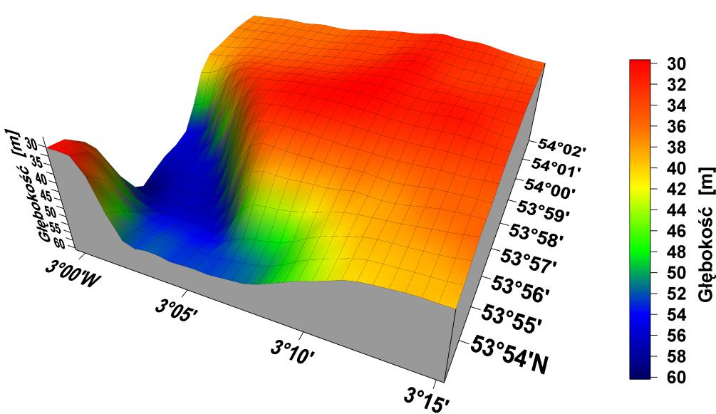
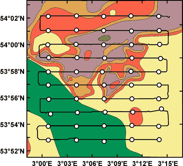
10 Map of backscattered signal intensity Rewal area 1 ridges boulder clay and gyttja; 2 fine and medium grained sand; isolated outcrops of lacustrine gyttja and mud covered with a layer of sand (up to 30cm); 3 slopes of elevations, medium-grained sands
11 CLASSIFICATION ALGORITHM I Multibeam echosounder echo intensity 19 parameters of Fourier transformation computed for angular dependency of backscatter intensities Classified bottom sediments Segmentation algorithm Unsupervised Kohonen s neural network
 Classified seafloor geomorphological forms Segmentation algorithm Unsupervised Kohonen s neural")
12 CLASSIFICATION ALGORITHM II Multibeam echosounder echo intensity 9 parameters computed for angular dependency of backscatter intensities energies of wavelet transformation (Coiflet wavelets) Classified seafloor geomorphological forms Segmentation algorithm Unsupervised Kohonen s neural network

13 COMPARISON OF CLASSIFICATION RESULTS seafloor geomorphologic forms types of sediment

14 MULTIBEAM ECHOSOUNDER SNIPPETS IDEA ONGOING WORK ICES COOPERATIVE RESEARCH REPORT NO. 286
15 APL-UW* MODEL OF BOTOOM BACKSCATTERING STRENGTHS at 100 khz BBS *Applied Physics Lab. Univ. of Washington
16 SNIPPETS NORBIT S MULTIBEAM ECHOSOUNDER IDEA OF CLASSIFICATION ALGORITHM Calibrated echosounder Real levels of the Bottom Backscattering Strength for different angles of incidence Shape parameters of snippets The above parameters will be input to the classification algorithm
17 Object-Based Image Analysis marine seafloor mapping Łukasz Janowski PhD student General Workflow: 1.Processing of the MBES DEM and backscatter mosaic 2.Feature extraction and selection 3.OBIA segmentation and classification, accuracy assessment Trimble ecognition software Standard deviation of backscatter, Gray Level Co-occurance Matrix (GLCM), textural features ArcGIS - Bethic Terrain Modeler Toolbox Rugosity, slope, variance, aspect, northness, eastness, curvature, profile curvature, planar curvature, BPI (Bathymetric Position Index), sd (standard deviation) of some features CART Classififcation and Regression Trees allow to distinguish characteristic features of the image (eg. DEM and BBS)
 (clay) (fine sand) (very fine sand) Producer 1 undefined 1 0.")
18 OBIA segmentation and classification, accuracy assessment Łukasz Janowski Multiresolution segmentation of scale 280 and CART classifier Result: set of if-then rules dependent of backscatter and rugosity Error matrix Reference Class User MS C FS VFS Sum MS C FS VFS Sum (muddy sand) (clay) (fine sand) (very fine sand) Producer 1 undefined User undefined 1 1 Overall Accuracy KIA

19 SIDESCAN SONAR Seafloor classification systems - IDEAS Object-Based Image Analysis same metod as presented for MBES 2D Wavelet Transform parameters EXAMPLE OF MULTIPLE LEVEL WAVELET DECOMPOSITION APPLIED FOR SIDESCAN SONAR IMAGERY strong reflection stony bottom mound acoustical shadow vegetations
20 ( ) ( ) ( ) D N V N H N N D N V N H N D V H D D D A D D D D D D S,,,,,...,, = MULTIPLE LEVEL WAVELET DECOMPOSITION TREE Biorthogonal wavelets - Bior3.7, Bior6.8


21 WAVELET DECOMPOSITION AND SYNTHESIS OF SIDESCAN SONAR IMAGERY DECOMPOSITION Multiple Level Wavelet Decomposition Approximation A2 Horizontal Detail H3 Diagonal Detail D SYNTHESIS Segmentation algorithms Unsupervised Kohonen s neural network or Fuzzy c-means cluster analysis


![651500000 Northing [m] Northing [m] 3 clusters 651400000 651300000 651400000 651300000](/docs-images/78/77481245/images/22-2.jpg "651200000 651200000 651100000 651100000 615000000 615200000 Easting [m] 615400000")
22 CLASSIFICATION OF BOTTOM STRUCTURES USING PARAMETRICAL ECHOSOUNDER AND SUBBOTTOM PROFILER DATA Extraction of Seabed/Subsurface Features in a Potential CO2 Sequestration Site in the Southern Baltic Sea, Using Wavelet Transform of High-resolution Sub-Bottom Profiler Data 4 clusters Northing [m] Northing [m] 3 clusters Easting [m] Easting [m]


23 LIDAR data 1.Object-Based Image Analysis same method as used for MBES data 2.Statistical and Spectral Features of Corrugated Seafloor 2D Fourier Analysis Example of autocorrelation length computation using 2D FFT and the Wiener Khinchin theorem MBES data Hornsund fjord, West Spitsbergen Autocorrelation length DEM - seafloor
24 WP 5 Strengths, Weaknesses, Opportunities, and Threats (SWOT) Strengths We are experienced in acoustical classification of bottom sediments, geomorphological forms and structures. We have good quality equipment. Weaknesses Too many methods, too many different kinds of data, too many algorithms. Opportunities We have an opportunity to make progress in methods of non-invasive seabed investigation. Threats Too short time for testing and improvement of all new algorithms.


25 THANK YOU VERY MUCH FOR YOUR ATTENTION
SEABED CLASSIFICATION FROM MULTIBEAM ECHOSOUNDER BACKSCATTER DATA USING WAVELET TRANSFORMATION AND NEURAL NETWORK APPROACH
 SEABED CLASSIFICATION FROM MULTIBEAM ECHOSOUNDER BACKSCATTER DATA USING WAVELET TRANSFORMATION AND NEURAL NETWORK APPROACH Jaroslaw Tegowski a,b, Jaroslaw Nowak a, Mateusz Moskalik c, Kazimierz Szefler
Not to be cited without prior reference to the author
 Not to be cited without prior reference to the author ICES CM 2011/G:04 Acoustic studies of benthic habitats in South Baltic Sea using parametric signal processing technique for singlebeam and multibeam
are extensively researched over the past few decades, both experimentally and
 Chapter 1 Introduction 1.1 BACKGROUND Acoustic interaction with the seafloor and the properties of seafloor sediments are extensively researched over the past few decades, both experimentally and theoretically.
Acoustical recognition of the bottom sediments in the southern Baltic Sea
 Acoustical recognition of the bottom sediments in the southern Baltic Sea PACS: 43.30.Ma Jaros³aw Têgowski Institute of Oceanology, Polish Academy of Sciences, Powstañców Warszawy 55,8-7 Sopot, Poland,
WP. 4 Detection and characterization of CWA dumpsites. Zygmunt Klusek Ulf Olsson
 WP. 4 Detection and characterization of CWA dumpsites Zygmunt Klusek Ulf Olsson Stockholm 02.03.2013 Zygmunt Klusek & Ulf Olsson WP. 4 Detection and characterization of CWA dumpsites 0.2.03.2013 This page
Multiple methods, maps, and management applications: purpose made maps in support of Ocean Management. Craig J. Brown McGregor GeoScience Ltd.
 Multiple methods, maps, and management applications: purpose made maps in support of Ocean Management Craig J. Brown McGregor GeoScience Ltd. International workshop on seabed mapping methods and technology,
Sediment classification from multibeam backscatter images using simple histogram analysis
 Sediment classification from multibeam backscatter images using simple histogram analysis Rozaimi Che Hasan 1,2, Mohd Razali Mahmud 3 and Shahrin Amizul Shamsudin 1 1 UTM Razak School of Engineering and
IEEE JOURNAL OF OCEANIC ENGINEERING, VOL. 36, NO. 2, APRIL
 IEEE JOURNAL OF OCEANIC ENGINEERING, VOL. 36, NO. 2, APRIL 2011 259 Principal Component Analysis of Single-Beam Echo-Sounder Signal Features for Seafloor Classification Ali R. Amiri-Simkooei, Mirjam Snellen,
Benthic habitat mapping: a synopsis of methodologies and approaches. Dr. Craig Brown University of Ulster
 Benthic habitat mapping: a synopsis of methodologies and approaches Dr. Craig Brown University of Ulster Technological advances in remote sensing Insitu sampling Improving technology Single beam acoustics/video
Evaluation of a new hydroacoustic substrate classification system for oyster reef mapping in Galveston Bay, Texas
 Evaluation of a new hydroacoustic substrate classification system for oyster reef mapping in Galveston Bay, Texas Introduction Importance of Oyster Reef Resources Vital in maintaining the Galveston Bay
River bed classification using multi-beam echo-sounder backscatter data
 River bed classification using multi-beam echo-sounder backscatter data Niels Kinneging Mirjam Snellen Dimitrios Eleftherakis Dick Simons Erik Mosselman Arjan Sieben 13 November 2012 transport water management
Geophysical Site Surveys
 Geophysical Site Surveys Simon Oakley Geoscience Team Leader Fugro Survey Limited 16/04/2014 Contents Menu Introduction Section 1 - Geophysical Site Surveys - Seabed Bathymetry - Shallow Geology - Seabed
Changes in bottom morphology of Long Island Sound near Mount Misery Shoal as observed through Repeated Multibeam Surveys
 Changes in bottom morphology of Long Island Sound near Mount Misery Shoal as observed through Repeated Multibeam Surveys Laurie A. Zaleski Laurie.Zaleski@msrc.sunysb.edu Roger D. Flood rflood@notes.cc.sunysb.edu
Changes in Geomorphology and Backscatter Patterns in Mount Misery Shoal, Long Island Sound as Revealed through Multiple Multibeam Surveys
 Changes in Geomorphology and Backscatter Patterns in Mount Misery Shoal, Long Island Sound as Revealed through Multiple Multibeam Surveys Laurie A. Zaleski Laurie.Zaleski@msrc.sunysb.edu, Roger D. Flood
Acoustic seafloor mapping systems. September 14, 2010
 Acoustic seafloor mapping systems September 14, 010 1 Delft Vermelding Institute onderdeel of Earth organisatie Observation and Space Systems Acoustic seafloor mapping techniques Single-beam echosounder
FINMARINET: Inventories and Planning for the Marine Natura 2000 Network in Finland. A.2 Geological inventories of the seafloor Final Report
 LIFE07 NAT/FIN/000151 FINMARINET: Inventories and Planning for the Marine Natura 2000 Network in Finland A.2 Geological inventories of the seafloor Final Report Geological Survey of Finland, GTK 1. Introduction
Recent developments in multi-beam echo-sounder processing at the Delft
 Recent developments in multi-beam echo-sounder processing at the Delft University of Technology Prof. Dr. Dick G. Simons Acoustic Remote Sensing Group, Faculty of Aerospace Engineering, Delft University
SEAFLOOR PROPERTIES AND SEGMENTATION
 SEAFLOOR PROPERTIES AND SEGMENTATION G. CANEPA, N. G. PACE, E. POULIQUEN, P. FRANCHI, R. LOMBARDI, C. SISTI NATO Undersea Research Centre Viale San Bartolomeo 400, I-19138 La Spezia, Italy E-mail: canepa@saclantc.nato.int
12/11/2013& egm502 seafloor mapping
 egm502 seafloor mapping lecture 13 multi-beam echo-sounders The majority of the current charts of the ocean floors have been produced from single beam echo-sounder data. Even though these data have been
Rock Boulder RockSand 1 RockSand 2 RockSand 3 Sand
 Figure 15. Histogram comparison of ROV observed primary substrates determined from 33,605 dgps positions to RoxAnn seabed classification. Pie charts represent the percentage of ROV modified primary substrate
IDENTIFICATION OF SEAFLOOR HABITATS IN COASTAL SHELF WATERS USING A MULTIBEAM ECHOSOUNDER
 IDENTIFICATION OF SEAFLOOR HABITATS IN COASTAL SHELF WATERS USING A MULTIBEAM ECHOSOUNDER Parnum, I.M.*(1) & (2), Siwabessy, P.J.W. (1) & (2) and Gavrilov A.N. (1) (1) Centre for Marine Science and Technology,
Cold Water Coral WHY?
 The Cold Water Coral Research by bathymetry, acoustic geophysical and methane data, Santa Maria di Leuca, Northern Ionian Sea Apulian continental slop. Speaker: Kuan-Ting Lin March 15 th 2012 WHY? Where
Echo Features Analysis
 Chapter 5 Echo Features Analysis 5.1 OVERVIEW Classification of seafloor sediments is mainly a criteria based data processing algorithm to segment seafloor sediments in homogeneous groups using the properties
The data for Practical 2 is available for download at the dropbox link embedded in the I sent you.
 EGM310 UNDERWATER REMOTE SENSING PRACTICALS RORY QUINN PRACTICAL 2: MBES BACKSCATTER DATA Aim of practical To gain confidence in interpreting backscatter data derived from multi-beam echo-sounder surveys,
An overview of the use of acoustic data for geology and habitat mapping in MAREANO
 An overview of the use of acoustic data for geology and habitat mapping in MAREANO Margaret Dolan, Valerie Bellec, Sigrid Elvenes, Reidulv Bøe, Terje Thorsnes, Shyam Chand, Leif Rise, Monica Winsborrow
Introduction to Acoustic Remote Sensing and Seafloor Mapping (AE4-E13) May 19, 2010
 May 19, 2010") Introduction to Acoustic Remote Sensing and Seafloor Mapping (AE4-E13) May 19, 2010 1 Delft Vermelding Institute onderdeel of Earth organisatie Observation and Space Systems Why Acoustic Remote Sensing?
Introduction to Acoustic Remote Sensing and Seafloor Mapping (AE4-E13) May 19, 2010 1 Delft Vermelding Institute onderdeel of Earth organisatie Observation and Space Systems Why Acoustic Remote Sensing?
GG710 Remote Sensing in Submarine Environments Sidescan Sonar
 GG710 Remote Sensing in Submarine Environments Sidescan Sonar Harold Edgerton, a professor of electrical engineering at the Massachusetts Institute of Technology, developed sidescan sonar technology for
A lithological map created from multibeam backscatter data in challenging circumstances: the Lower Sea Scheldt estuary
 A lithological map created from multibeam backscatter data in challenging circumstances: the Lower Sea Scheldt estuary Mieke Mathys*, Marc Sas*, Frederik Roose** HYDRO12, Rotterdam, 15/11/2012 *International
STATISTICAL ANALYSIS FOR AUTOMATED SEEP EXTRACTION IN GIS
 STATISTICAL ANALYSIS FOR AUTOMATED SEEP EXTRACTION IN GIS Presented by Pamela Kanu, GISP ESRI USER CONFERENCE JULY 2017 SEEPS Seeps are natural gas and crude oil that enter the ocean through cracks and
APPLICATIONS OF THE HUANG HILBERT TRANSFORMATION IN NON-INVASIVE RESEARCH OF THE SEABED IN THE SOUTHERN BALTIC SEA
 Volume 17 HYDROACOUSTICS APPLICATIONS OF THE HUANG HILBERT TRANSFORMATION IN NON-INVASIVE RESEARCH OF THE SEABED IN THE SOUTHERN BALTIC SEA MIŁOSZ GRABOWSKI 1, JAROSŁAW TĘGOWSKI 2, JAROSŁAW NOWAK 3 1 Institute
COBRA Cable Site Investigation in the Wadden Sea, Denmark
 NGM 2016 Reykjavik Proceedings of the 17 th Nordic Geotechnical Meeting Challenges in Nordic Geotechnic 25 th 28 th of May COBRA Cable Site Investigation in the Wadden Sea, Denmark L. Klinkby COWI, Denmark,
GEOPHYSICAL TECHNIQUES FOR MARITIME ARCHAEOLOGICAL SURVEYS. Abstract
 GEOPHYSICAL TECHNIQUES FOR MARITIME ARCHAEOLOGICAL SURVEYS Mark Lawrence, Wessex Archaeology, Salisbury, UK, Ian Oxley, English Heritage, Portsmouth, UK, C. Richard Bates, University of St. Andrews, St.
Observations of the Spatial and Temporal Variability of Wave Formed Ripples from the 2007 Martha's Vineyard RipplesDRI Experiment
 Observations of the Spatial and Temporal Variability of Wave Formed Ripples from the 2007 Martha's Vineyard RipplesDRI Experiment Dr. Peter Traykovski Woods Hole Oceanographic Institution Applied Ocean
The Arctic - A New Frontier The geological, environmental and engineering challenges for submarine telecommunication cables
 The Arctic - A New Frontier The geological, environmental and engineering challenges for submarine telecommunication cables Ryan Wopschall 5 September 2013 Oceanology International China, Shanghai Fugro
Current and Future Technology Applications for Coastal Zone Management. Bruce K. Carlisle, Acting Director Office of Coastal Zone Management
 Current and Future Technology Applications for Coastal Zone Management Bruce K. Carlisle, Acting Director Office of Coastal Zone Management The Massachusetts Coastal Zone Management Program Approved in
Relationship between gas-bearing (?) sediments and biogenic mounds in the Kalloni Gulf, Lesvos Island, Greece
 sediments and biogenic mounds in the Kalloni Gulf, Lesvos Island, Greece") 6 th Workshop Seabed Acoustics, Rostock, November 14/15, 2013 P13-1 Relationship between gas-bearing (?) sediments and biogenic mounds in the Kalloni Gulf, Lesvos Island, Greece Alexandros Chronis, Dr.
6 th Workshop Seabed Acoustics, Rostock, November 14/15, 2013 P13-1 Relationship between gas-bearing (?) sediments and biogenic mounds in the Kalloni Gulf, Lesvos Island, Greece Alexandros Chronis, Dr.
River bed classification using multi-beam echo-sounder backscatter data. Niels KINNEGING Rijkswaterstaat Centre for Water Management
 River bed classification using multi-beam echo-sounder backscatter data Niels KINNEGING Rijkswaterstaat Centre for Water Management Mirjam SNELLEN Delft University of Techonology Dimitrios ELEFTHERAKIS
Inspection of Waterfront Facilities Using Vessel-Based Remote Sensing Mitchell, Del Bello, Suarez
 Inspection of Waterfront Facilities Using Vessel-Based Remote Sensing Mitchell, Del Bello, Suarez American Association of Port Authorities Facilities Engineering Conference October 20-22, 2015 Waterfront
2) re-positioning of the SSS data, 3) individuation of geomorphological features and morphometrical parameters correlated to instability phenomena.
 re-positioning of the SSS data, 3) individuation of geomorphological features and morphometrical parameters correlated to instability phenomena.") HIGH-RESOLUTION SIDE SCAN SONAR AND MULTIBEAM DATA PROCESSING AND MERGING TO STUDY SUBMARINE INSTABILITY PHENOMENA ON VOLCANIC ISLANDS (PONTINE, CAMPANIAN AND AEOLIAN ARCHIPELAGOS) A. BOSMAN Extended abstract:
HIGH-RESOLUTION SIDE SCAN SONAR AND MULTIBEAM DATA PROCESSING AND MERGING TO STUDY SUBMARINE INSTABILITY PHENOMENA ON VOLCANIC ISLANDS (PONTINE, CAMPANIAN AND AEOLIAN ARCHIPELAGOS) A. BOSMAN Extended abstract:
Benthic habitat mapping using multibeam sonar
 Benthic habitat mapping using multibeam sonar Iain M. Parnum 1, Alexander Gavrilov 1 and Justy Siwabessy 2 1. Centre for Marine Science and Technology, Curtin University, Perth, Australia 2. Geoscience
Observations regarding coarse sediment classification based on multi-beam echo-sounder s backscatter strength and depth residuals in Dutch rivers
 Observations regarding coarse sediment classification based on multi-beam echo-sounder s backscatter strength and depth residuals in Dutch rivers Dimitrios Eleftherakis, Mirjam Snellen, a) AliReza Amiri-Simkooei,
Side Scan Sonar Results for Additional Hardbottom Habitat Identification in Charleston Entrance Channel
 U.S. Army Corps of Engineers Charleston District APPENDIX H CHARLESTON HARBOR POST 45 BENEFICIAL USE OF DREDGED MATERIAL SUPPLEMENTAL ENVIRIONMENTAL ASSESSMENT CHARLESTON, SOUTH CAROLINA Side Scan Sonar
US ARMY CORPS OF ENGINEERS New England District BUILDING STRONG
 US ARMY CORPS OF ENGINEERS New England District STUDIES Sediment Sampling Biological Sampling (benthic community analysis) Hydroacoustic Surveys (side scan sonar, bathymetry) Remotely Operated Vehicle
Topic: Bathymetric Survey Techniques. (a) Single-beam echo-sounders (SBES) (b) Multi-beam echo-sounders (MBES)
 Single-beam echo-sounders (SBES) (b) Multi-beam echo-sounders (MBES)") Topic: Bathymetric Survey Techniques (a) Single-beam echo-sounders (SBES) (b) Multi-beam echo-sounders (MBES) Bathymetry is the measurement of water depths - bathymetry is the underwater equivalent of
Topic: Bathymetric Survey Techniques (a) Single-beam echo-sounders (SBES) (b) Multi-beam echo-sounders (MBES) Bathymetry is the measurement of water depths - bathymetry is the underwater equivalent of
Costas Armenakis (York University), Craig Brown (NSCC), Paul Brett (Marine Institute, Memorial University), Ian Church (UNB), Sylvie Daniel (Laval
, Craig Brown (NSCC), Paul Brett (Marine Institute, Memorial University), Ian Church (UNB), Sylvie Daniel (Laval") Costas Armenakis (York University), Craig Brown (NSCC), Paul Brett (Marine Institute, Memorial University), Ian Church (UNB), Sylvie Daniel (Laval University), Sean Galway (BCIT), Anders Knudsby (Ottawa
Costas Armenakis (York University), Craig Brown (NSCC), Paul Brett (Marine Institute, Memorial University), Ian Church (UNB), Sylvie Daniel (Laval University), Sean Galway (BCIT), Anders Knudsby (Ottawa
MONITORING OF VENICE INLET CHANNELS. Sharing knowledge to make data available for everyone
 MONITORING OF VENICE INLET CHANNELS Sharing knowledge to make data available for everyone Introduction What does hydrography really mean? IHO defines hydrography as a description of the physical features
Trimble s ecognition Product Suite
 Trimble s ecognition Product Suite Dr. Waldemar Krebs October 2010 Trimble Geospatial in the Image Processing Chain Data Acquisition Pre-processing Manual/Pixel-based Object-/contextbased Interpretation
Kyle Griebel NRS 509 Dr. August & Dr. Wang GIS and remote sensing in Seafloor mapping
 GIS and remote sensing in Seafloor mapping Introduction to seafloor mapping Seafloor maps have a wide variety of uses for scientists and coastal planning needs. Some of these uses include biological assessment
High-resolution bottom albedo images and benthic habitat classification to develop baseline management tools in Natural Reserves
 High-resolution bottom albedo images and benthic habitat classification to develop baseline management tools in Natural Reserves *William J. Hernandez, Ph.D. and Roy A. Armstrong, Ph.D. *Post-Doctoral
INFOMAR Ground Truthing and Sampling Strategy
 INFOMAR Ground Truthing and Sampling Strategy DOCUMENT INFORMATION Contributors Geological Survey of Ireland: Sean Cullen, David Hardy, Xavier Monteys, Ronan O Toole, Koen Verbruggen. Marine Institute:
Quantitative Analysis of Terrain Texture from DEMs Based on Grey Level Co-occurrence Matrix
 Quantitative Analysis of Terrain Texture from DEMs Based on Grey Level Co-occurrence Matrix TANG Guo an, LIU Kai Key laboratory of Virtual Geographic Environment Ministry of Education, Nanjing Normal University,
The STRATAFORM Swathmapping Program
 LONG-TERM GOALS: The STRATAFORM Swathmapping Program Larry Mayer Ocean Mapping Group Dept. of Geodesy and Geomatics Engineering University of New Brunswick Fredericton, N.B. Canada E3B 5A3 phone: (506)
Using the MBES for classification of riverbed sediments
 Acoustics 8 Paris Using the MBES for classification of riverbed sediments A. Amiri-Simkooei a, M. Snellen a and D. G Simons b a Acoustic Remote Sensing Group, Delft Institute of Earth Observation and Space
Automated Seabed Mapping and Data Delivery in the Cloud
 Automated Seabed Mapping and Data Delivery in the Cloud London, 2nd November 2017 11/20/2017 1 2 WE CALL IT SEABED INTELLIGENCE Ocean Infinity are explorers. We go to unmapped locations to survey the seabed
COMPARATIVE STUDY BETWEEN FLAT AND UNIFORM BOTTOM ASSUMPTIONS FOR SNIPPET IMAGERIES IN HYDROGRAPHIC APPLICATIONS
 COMPARATIVE STUDY BETWEEN FLAT AND UNIFORM BOTTOM ASSUMPTIONS FOR SNIPPET IMAGERIES IN HYDROGRAPHIC APPLICATIONS Rubasingam R., Mahmud M.R. and Gunathilaka M.D.E.K. Hydrographic Research and Training Office,
NOAA/University of New Hampshire Joint Hydrographic Center & Center for Coastal and Ocean Mapping. MAPPS Summer Conference July 23, 2013
 NOAA/University of New Hampshire Joint Hydrographic Center & Center for Coastal and Ocean Mapping MAPPS Summer Conference July 23, 2013 07/23/2013 2 07/23/2013 3 Center Goals To be a world leader in the
7.0 Project Reports 7.1 Geophysical Mapping of Submarine Environments
 7.0 Project Reports 7.1 Geophysical Mapping of Submarine Environments Suzanne Carbotte, Robin Bell, Roger Flood 7.1.1 METHODS In April 2000 we deployed the R/V Onrust, operated by MSRC at SUNY Stony Brook,
Limits and Potentials of High Resolution Terrestrial Laser Scanning in Monitoring Estuarine Geomorphologic Variability.
 Limits and Potentials of High Resolution Terrestrial Laser Scanning in Monitoring Estuarine Geomorphologic Variability Charlie Endris January 20, 2010 Elkhorn Slough: Erosion and Habitat Loss Evolution
Monitoring The Sand Extraction On The Belgian Continental Shelf
 Monitoring The Sand Extraction On The Belgian Continental Shelf Methodology, Results And Expectations K. Degrendele and M. Roche Within the framework of a sustainable exploitation of the mineral resources
Improving riverbed sediment classification using backscatter and depth residual features of multi-beam echo-sounder systems
 Improving riverbed sediment classification using backscatter and depth residual features of multi-beam echo-sounder systems Dimitrios Eleftherakis, a) AliReza Amiri-Simkooei, b) Mirjam Snellen, and Dick
CHAPTER 6 RESULTS FIGURE 8.- DATA WORK FLOW FOR BACKSCATTER PROCESSING IN HYPACK
 CHAPTER 6 RESULTS 6.1. Backscatter Workflow Comparison Currently, INOCAR owns and operates RESON and Kongsberg multibeam systems for nearshore surveys. The RESON system is integrated with HYPACK Hysweep
Mission of the Network
 Mission of the Network The purpose of the COMREN is to Develop research activities, Achieve technology transfer to the Industry, Develop and run educational programs, in liaison with government agencies,
Autonomous Underwater Vehicle sensors fusion by the theory of belief functions for Rapid Environment Assessment
 Autonomous Underwater Vehicle sensors fusion by the theory of belief functions for Rapid Environment Assessment Arnaud Martin 1, Jean-Christophe Cexus 1, Gilles Le Chenadec 2, Elodie Cantéro 2, Thierry
National Marine Sanctuary Program
 National Marine Sanctuary Program NMSP/USGS Joint Seabed Mapping Initiative: September 2004 AA National Ocean Service National Marine Sanctuaries Interim Report September 2004 Background: Since 2002,
NEW SEAFLOOR INSTALLATIONS REQUIRE ULTRA-HIGH RESOLUTION SURVEYS
 NEW SEAFLOOR INSTALLATIONS REQUIRE ULTRA-HIGH RESOLUTION SURVEYS Donald Hussong (Fugro Seafloor Surveys, Inc.) dhussong@fugro.com Fugro Seafloor Surveys, Inc., 1100 Dexter Avenue North (Suite 100), Seattle,
MBES BS calibration on reference patch areas using singlebeam calibrated data
 MBES BS calibration on reference patch areas using singlebeam calibrated data Southampton, U.K. Brussels, Belgium NOC 3 FPS Economy 2, Continental Shelf Service D. Eleftherakis 1, X. Lurton 1, J.M. Augustin
Parametric Sub Bottom Profiler measurements of the subaquatic portion of the debris fan of Gschliefgraben in Lake Traunsee, Austria
 Parametric Sub Bottom Profiler measurements of the subaquatic portion of the debris fan of Gschliefgraben in Lake Traunsee, Austria Brian Kreis & Sebastian Riegler (students) Erwin Heine supported by INNOMAR
Influence of microphytobenthos photosynthesis on the spectral characteristics of the signal reflected from Baltic sandy sediments
 Influence of microphytobenthos photosynthesis on the spectral characteristics of the signal reflected from Baltic sandy sediments Damian JAŚNIEWICZ 1, Natalia GORSKA 2 1 Institute of Oceanology, PAS Powstańców
Supplement of Scenario-based numerical modelling and the palaeo-historic record of tsunamis in Wallis and Futuna, Southwest Pacific
 Supplement of Nat. Hazards Earth Syst. Sci., 15, 1763 1784, 2015 http://www.nat-hazards-earth-syst-sci.net/15/1763/2015/ doi:10.5194/nhess-15-1763-2015-supplement Author(s) 2015. CC Attribution 3.0 License.
R.C. Searle P.M. Hunter Institute of Oceanographic Sciences Wormley, Godalming, Surrey, GU8 SUB
 THE USE OF GLORIA LONG-RANGE SIDESCAN SONAR FOR DEEP-OCEAN MAPPING R.C. Searle P.M. Hunter Institute of Oceanographic Sciences Wormley, Godalming, Surrey, GU8 SUB ABSTRACT The Institute of Oceanographic
GIS USE IN THE STUDY OF ESTUARINE SOILS AND SEDIMENTS Margot K. Payne NRS 509 November 30, 2005
 GIS USE IN THE STUDY OF ESTUARINE SOILS AND SEDIMENTS Margot K. Payne NRS 509 November 30, 2005 Throughout the world, estuaries are not only some of the most ecologically productive environments, but are
Acoustic classification of fine-scale sediment variability and interconnection with benthic habitats of the Eckernförde Bay, Kiel
 7 th Workshop Seabed Acoustics, Rostock, November 19/20, 2015 P11-1 Acoustic classification of fine-scale sediment variability and interconnection with benthic habitats of the Eckernförde Bay, Kiel Evangelos
Lower 8.3 Miles of the Lower Passaic River Operable Unit 2 Presentation to The Passaic River Community Advisory Group. September 14, 2017
 Lower 8.3 Miles of the Lower Passaic River Operable Unit 2 Presentation to The Passaic River Community Advisory Group September 14, 2017 Agenda Pre-Design Investigation (PDI) Status Geophysical, Bathymetric,
Bathymetric lidar to support pre-engineering analysis for marine liquefied natural gas transport infrastructure
 Bathymetric lidar to support pre-engineering analysis for marine liquefied natural gas transport infrastructure Candace MacDonald, Dr. Tim Webster Kate Collins, Nathan Crowell, Kevin McGuigan NSCC Applied
Classification of geodiversity in a natural tidal inlet system based on topobathymetric LiDAR data
 Classification of geodiversity in a natural tidal inlet system based on topobathymetric LiDAR data MSc Thesis, September 2015 Mikkel Skovgaard Andersen DANCORE, 2/10-2015, Copenhagen Content 1. Motivation
3.2 Geophysical Habitat Mapping
 APPENDIX 3 GEOPHYSICS Prepared for: Namibian Marine Phosphate (Pty) Ltd. Prepared by: Jeremy Midgley September 2014 Mr Jeremy Midgley Pr.Sci.Nat J. Midgley & Associates PO Box 110 Constantia 7806 South
Seabed Geoacoustic Structure at the Meso-Scale
 DISTRIBUTION STATEMENT A. Approved for public release; distribution is unlimited. Seabed Geoacoustic Structure at the Meso-Scale Charles W. Holland The Pennsylvania State University Applied Research Laboratory
Joint Hydrographic Center, National Oceanic and Atmospheric Administration, Durham, NH 03824, USA
 Future directions in hydrography using satellite-derived bathymetry Shachak Pe eri 1, Christopher Parrish 2, 3, Lee Alexander 1, Chukwuma Azuike 1, Andrew Armstrong 1,3 and Maryellen Sault 2 1 Center for
High-frequency seafloor acoustic backscatter from coastal marine habitats of Australia
 High-frequency seafloor acoustic backscatter from coastal marine habitats of Australia Iain Parnum (1) and Alexander Gavrilov (1) (1) Centre for Marine Science and Technology, Curtin University, Perth,
Detailed mapping of seabed topography,
 MAREANO program Detailed mapping of seabed topography, sediments, bottom fauna and pollutants in Norwegian waters HYDROGRAPHIC DATA FOR THE BENEFIT OF SOCIETY MAREANO program - Detailed mapping of seabed
3-D Visualization of Morphology and Distribution of Acoustic Facies in the Strataform Study Areas
 3-D Visualization of Morphology and Distribution of Acoustic Facies in the Strataform Study Areas Larry Mayer Ocean Mapping Group Dept. of Geodesy and Geomatics Engineering University of New Brunswick
Ultrasonic Measuring System for Deposition of Sediments in Reservoirs
 MECAHITECH 11, vol. 3, year: 011 Ultrasonic Measuring System for Deposition of Sediments in Reservoirs M. Mărgăritescu* 1, A. Moldovanu * 1, P. Boeriu *, A.M.E. Rolea* 1 * 1 National Institute of Research
MID-TERM CONFERENCE CREST
 MID-TERM CONFERENCE CREST 23 November 2017 Innovation in Coastal Monitoring Alain De Wulf (Ugent, Geography Dept.) Innovation in coastal monitoring Outline Why? How? What (tools do we use to assess)? Conclusion
Backscatter calibration for MBES Project Shom / Ifremer
 Backscatter calibration for MBES Project Shom / Ifremer Christophe Vrignaud Sophie Loyer Julian Le Deunf (Shom) Xavier Lurton - Jean-Marie Augustin Laurent Berger (Ifremer) INTRODUCTION The main need:
Shape of the seafloor. Shape of the seafloor. Shape of the seafloor. Shape of the seafloor. Shape of the seafloor. Shape of the seafloor
 Multibeam echo sounders - Research vessel Scripps Institution of Oceanography R/V Roger Revelle depth Source: Scripps Institution of Oceanography http://woodshole.er.usgs.gov/project-pages/caribbean/movie1.html
Oceanography, An Invitation to Marine Science 9e Tom Garrison. Ocean Basins Cengage Learning. All Rights Reserved.
 Oceanography, An Invitation to Marine Science 9e Tom Garrison 4 Ocean Basins Key Concepts Tectonic forces shape the seabed The ocean floor is divided into continental margins and deep ocean basins The
Autonomous Platforms for Marine Mapping and Monitoring: A UK Perspective. Dr Russell B Wynn (Head of NOC Marine Geoscience, MARS Chief Scientist)
") Autonomous Platforms for Marine Mapping and Monitoring: A UK Perspective Dr Russell B Wynn (Head of NOC Marine Geoscience, MARS Chief Scientist) Marine mapping and monitoring: an escalating problem. Policy
Autonomous Platforms for Marine Mapping and Monitoring: A UK Perspective Dr Russell B Wynn (Head of NOC Marine Geoscience, MARS Chief Scientist) Marine mapping and monitoring: an escalating problem. Policy
Field and Numerical Study of the Columbia River Mouth
 DISTRIBUTION STATEMENT A. Approved for public release; distribution is unlimited. Field and Numerical Study of the Columbia River Mouth Guy Gelfenbaum 400 Natural Bridges Dr. Santa Cruz, CA 95060 Phone:
The 1st International Hydrographic Summer Camp 2007 in Germany. Volker Böder
 T2F Young Surveyors (2967) The 1st International Hydrographic Summer Camp 2007 in Germany Volker Böder Integrating the Generations FIG Working Week 2008 Stockholm, Sweden 14-19 June 2008 Motivation Missing
Estimation of Mean Grain Size of Seafloor Sediments using Neural Network
 Author version: Mar. Geophys. Res., vol.33; 2012; 45-53 Estimation of Mean Grain Size of Seafloor Sediments using Neural Network Chanchal De a, 1, Bishwajit Chakraborty b a G-FAST, P-1, Metcalfe House,
Coastal and Marine Ecological Classification Standard (CMECS)
") Coastal and Marine Ecological Classification Standard (CMECS) Mark Finkbeiner NOAA Coastal Services Center Presented at the International Workshop on Seabed Mapping Methods and Technology 18 October 2012
Coastal and Marine Ecological Classification Standard (CMECS) Mark Finkbeiner NOAA Coastal Services Center Presented at the International Workshop on Seabed Mapping Methods and Technology 18 October 2012
Dynamics of Ripples on the Sandy Inner Shelf off Martha s Vineyard: Surveys, Field Measurements, and Models
 Dynamics of Ripples on the Sandy Inner Shelf off Martha s Vineyard: Surveys, Field Measurements, and Models Christopher R. Sherwood U.S. Geological Survey, Woods Hole Science Center 384 Woods Hole Road
USING LANDSAT IN A GIS WORLD
 USING LANDSAT IN A GIS WORLD RACHEL MK HEADLEY; PHD, PMP STEM LIAISON, ACADEMIC AFFAIRS BLACK HILLS STATE UNIVERSITY This material is based upon work supported by the National Science Foundation under
Smart Survey Approach: Multibeam Echosounder and Integrated Water Column Data as an Added Value for Seep Hunting
 Smart Survey Approach: Multibeam Echosounder and Integrated Water Column Data as an Added Value for Seep Hunting HYDRO 2016 8 November 2016 Marco Filippone Introduction, Multibeam Sonars & water column
Quantitative experimental comparison of single-beam, sidescan, and multibeam benthic habitat maps
 1766 Quantitative experimental comparison of single-beam, sidescan, and multibeam benthic habitat maps Alexandre C. G. Schimel, Terry R. Healy, David Johnson, and Dirk Immenga Schimel, A. C. G., Healy,
USING HYPERSPECTRAL IMAGERY
 USING HYPERSPECTRAL IMAGERY AND LIDAR DATA TO DETECT PLANT INVASIONS 2016 ESRI CANADA SCHOLARSHIP APPLICATION CURTIS CHANCE M.SC. CANDIDATE FACULTY OF FORESTRY UNIVERSITY OF BRITISH COLUMBIA CURTIS.CHANCE@ALUMNI.UBC.CA
ERDAS ER Mapper Software
 ERDAS ER Mapper Software ER Mapper professional software is widely used in exploration industry and geologist worldwide for satellite image exploitation. It is known for its:- Powerful image processing
FOUNDATIONS FOR OFFSHORE STRUCTURES
 FOUNDATIONS FOR OFFSHORE STRUCTURES DELHI CHAPTER Pradeep Hora It takes less time to do a thing right than explain why you did it wrong. - Henry Wadsworth Longfellow 2 1 Site Investigations (Survey) What
Terje Pedersen Product Manager Software / Hydrography Hydroacoustics Division
 Terje Pedersen Product Manager Software / Hydrography Hydroacoustics Division WORLD CLASS through people, technology and dedication WORLD CLASS through people, technology and dedication 1 2 HYDROFEST 2005
AN ABSTRACT OF THE THESIS OF. Rizaller C. Amolo for the degree of Master of Science in Marine Resource Management presented on August 27, 2010.
 AN ABSTRACT OF THE THESIS OF Rizaller C. Amolo for the degree of Master of Science in Marine Resource Management presented on August 27, 2010. Title: Habitat Mapping and Identifying Suitable Habitat of