Topic: Bathymetric Survey Techniques. (a) Single-beam echo-sounders (SBES) (b) Multi-beam echo-sounders (MBES)
|
|
|
- Laurence Jacobs
- 5 years ago
- Views:
Transcription
 (b) Multi-beam echo-sounders")
1 Topic: Bathymetric Survey Techniques (a) Single-beam echo-sounders (SBES) (b) Multi-beam echo-sounders (MBES)

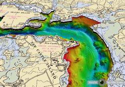
2 Bathymetry is the measurement of water depths - bathymetry is the underwater equivalent of terrestrial topography. A transect of water depths along a straight line is termed a bathymetric profile. A contour map of water depths is a bathymetric chart. The production of a detailed bathymetric base-map is a critical method for marine, freshwater, environmental and coastal investigations.

3
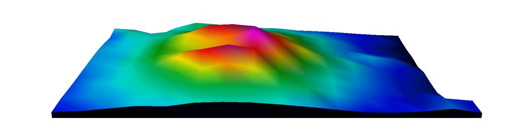
4 2-dimensional and 3-dimensional bathymetric models can aid our understanding and interpretation of the landscape and individual sites, providing morphological maps of the seabed, lakebed and riverbed. Conventionally, water depths are indicated by shades of blue - dark blue corresponding to deep water and light blue to shallow areas. However, any colour scale can be (and is) used. This survey technique provides very little detail on the material properties (e.g sediment type, roughness etc.) of the seabed or subsurface (see the following lectures on side-scan sonar and sub-bottom profilers). However, when combined with other geophysical techniques, bathymetric charts can act as a template for site-specific and reconnaissance scale surveys.


5 History of Bathymetric Survey The simplest and oldest means of bathymetric survey is the sounding pole. This technique involves using of a long straight pole to measure water depths - effective, but limited in use to shallow water. The sounding pole was replaced as a survey technique by the traditional lead-weighted line. Mariners conventionally took soundings in shallow water with a lead sinker on a fishing line primarily to locate navigational hazards and safe anchorages in near-shore zones and estuaries.
6 "Un%l"the"20th"Century,"the"lead"line"was"the"only"effec%ve"tool"for"deeper"water" bathymetric"measurement."" "The"line"was"tradi%onally"marked"with"knots"or"coloured"%es"at"regular"intervals."" "In"the"mid"1880's"piano"wire"was"used"as"replacement"for"the"fishing"line"G"this" allowed"for"greater"strength"of"line." "The"main"disadvantage"of"the"leadGweighted"line"was"that"the"survey"vessel"had"to" be"at"a"stands%ll"when"a"depth"measurement"was"taken."also"the"x"and"y"(la%tudeg longitude)"posi%on"of"the"survey"vessel"had"to"be"taken"manually"g"this"was"also"%meg consuming.""""


7 Sometimes the lead weight was hollowed to allow for packing with tallow or wax, and so a bottom sediment sample could be taken with the depth measurement. Seabed sediment samples are important to mariners to identify spawning ground, habitats, suitable anchorages etc..


8 Revolution of SONAR (SOund Navigation And Ranging) Early sonar systems, developed during World War I by the American, British, and French were used to find both submarines and icebergs. They were called ASDICs (named for the AntiSubmarine Detection Investigation Committee). These early units were crude if not effective.


9 "During"World"War"II,"underwater"acous%cs"made"great"leaps"and"enemy"submarines" could"be"detected"more"easily"by"surface"ships"as"they"sent"a"stronger"and"beoer"formed" sound"pulses"into"the"water."" "The"pulse"would"bounce"off"the"submarine's"hull"and"give"away"their"distance"from"the" surface"ship."" "Sonar"(an"acronym"for"SOund"NAviga%on"and"Ranging)"became"very"important"for"the" detec%on"of"submarines.""
.")
10 Modern Bathymetric Systems The accuracy of bathymetric surveys is dependent on both the acoustic (sonar) technique used and the effective integration of an accurate navigation system (GPS). Two systems are currently used for the acquisition of bathymetric data: a) Single Beam Echo Sounders (SBES) b) Multi Beam Echo Sounders (MBES)
11 MBES SBES

12 Area insonified MBES SBES
13 MBES SBES
 J.E. Hughes Clarke, OMG/UNB")
14 (a) Single Beam Echo Sounders (SBES) J.E. Hughes Clarke, OMG/UNB

15 5 STEPS TO ACQUIRING SBES DATA STEP 1 Single-beam echo-sounders comprise a single hull-mounted transducer that acts as both an acoustic transmitter and receiver (transceiver).
16 STEP%2% The"echoGsounder"system"produces"a"ver%cally"transmiOed"narrow"(typically"5G15 o )" acous%c"pulse"with"a"single"frequency"(typically"within"the"50"g"300"khz"range).""

17 J.E. Hughes Clarke, OMG/UNB
18 STEP%3"" The"SBES"records"the"%me"taken"for"an"acous%c"pulse"to"travel"from"the"transducer"to" the"seagbooom"and"back"again"(twogwayg%me).""" " two-way-time
19 STEP%4% The"water"depth"(d)"is"calculated"as"half"the"product"of"the"twoGwayG%me"(TWT)"and"the" mean"ver%cal"sounding"velocity"(v)."" d = TWT x V 2 The average velocity of an acoustic pulse travelling through seawater is 1480 ms -1, a figure that varies from place to place due to changes in seawater temperatue, pressure and salinity.
20 STEP%5% The"returns"(or"echoes)"are"detected"by"the"transceiver"and"recorded"and"displayed"in" hardcopy"or"digital"format."""

21 Typically, the bathymetric survey suite comprises a DGPS, a topside recorder/ viewer (usually a laptop PC), a transducer and a cable. The resultant data from a bathymetric survey is usually a 3-column ASCII data file containing X, Y and Z values, where: X = Longitude Y = Latitude Z = Depth (m)

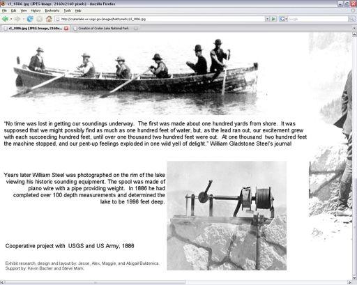
22 (b) Multi Beam Echo Sounders (MBES) A recent development from the echo-sounder is the swath (or multibeam) bathymetric system. By comparison to the focused beam of the echo-sounder, swath systems record continuous depth measurements along a swath that extends perpendicularly either side of the survey vessel, where a multi-element transducer provides many (30-150) individual soundings of the water depth and echo strength for each ping.

23 A wide swath (up to 7 times the water depth) can be surveyed in a single pass through an area at survey speeds up to 20 knots. Survey lines are spaced to provide overlapping coverage of the seafloor. These techniques have detected features that are often missed by ordinary bathymetric soundings as they inherently acquire much higher resolution data.

24
25

26


27 J.E. Hughes Clarke, OMG/UNB

28 Roll The rhythmic movement of a ship or towfish about its longitudinal axis. Yaw An instability characterized by the side-to-side movement of a ship or towfish about its vertical axis. Pitch An instability in the ship or towfish expressed by the alternate rise and fall of the nose and tail about a horizontal axis. J.E. Hughes Clarke, OMG/UNB pitch yaw heave roll
29 Inertial Measurement Unit (IMU) or Motion Referencing Unit (MRU) An Inertial Measurement Unit is a closed system that is used to detect altitude, location, and motion. Typically installed on survey vessels, it normally uses a combination of accelerometers and angular rate sensors (gyroscopes) to track how the vessel is moving. Typically, an IMU detects the current acceleration and rate of change in attitude (i.e. pitch, roll and yaw rates) and then sums them to find the total change from the initial position. These corrections are then applied to the geophysical data to correct for the effects of pitch, roll and yaw. An IMU stands in contrast to the GPS system, which uses external satellites to detect the current position.


30 EXAMPLE SYSTEM


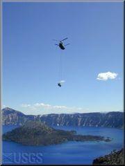
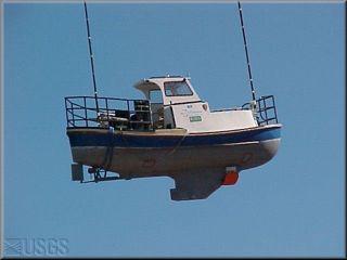
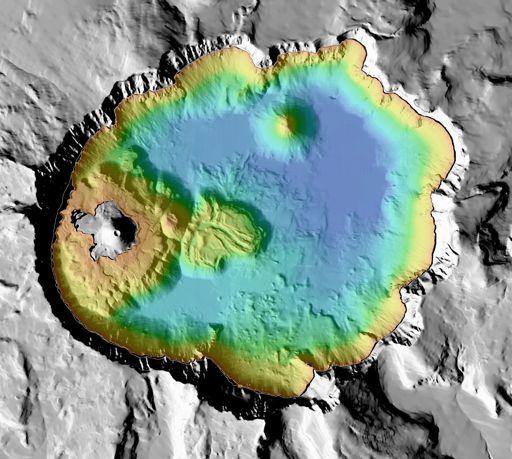
31 Case Study Mapping Crater Lake, Oregon State, USA Crater Lake, the deepest lake in the United States, occupies a caldera in Mount Mazama, a Cascade Range volcano that once stood about 3,700m. About 7,700 years ago in a catastrophic eruption that lasted only a few days, Mount Mazama ejected about 50 cubic km of magma in the form of pumice and ash. Near the end of the eruption, the mountain collapsed upon itself to form a large caldera. After this climactic event, volcanic activity resumed within the caldera, creating Wizard Island and other new landforms. All but the uppermost portion of the Wizard Island volcano is hidden from view below the surface of Crater Lake.
32 Until recently, nobody knew what the bottom of Crater Lake looked like in detail. The first indications of the lake depths came from an 1886 survey by a joint USGS/U.S. Army expedition led by William G. Steel and under the direction Maj. Clarence E. Dutton (Dutton, 1889). This mapping survey collected 186 soundings using a Millers lead-line sounding machine.


33 1886 Survey 186 soundings
 and Byrne (1962) and resulted in a fairly detailed map of the large-scale features within Crater Lake.")
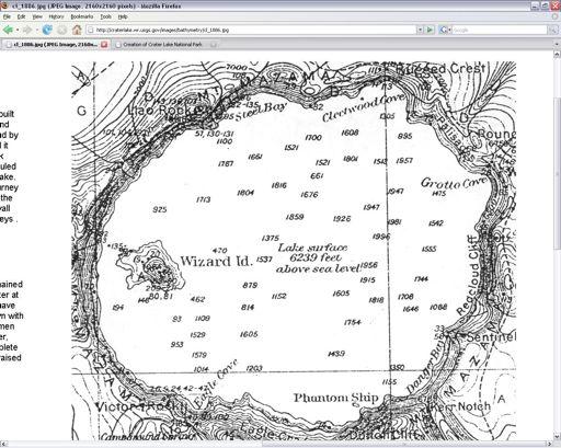
34 1959 Survey This survey used an acoustic echo sounder and radar navigation to collect 4000 soundings. The data were contoured by Williams (1961) and Byrne (1962) and resulted in a fairly detailed map of the large-scale features within Crater Lake. By the late 1990`s however, maps generated from this survey were proving inadequate for the scientific research being conducted in and around the lake.
35 2000 Survey U.S. Geological Survey, Pacific Seafloor Mapping Project in cooperation with the National Park Service and the Center for Coastal and Ocean Mapping, University of New Hampshire used a state-of-the-art multibeam sonar system to collect high-resolution bathymetry and calibrated, co-registered acoustic backscatter to support both biological and geological research in the area (aquatic biology, geochemistry, volcanic processes, etc). This survey collected over 16 million soundings and the resulting data portrays the bottom of Crater Lake at a spatial resolution of 2m.

36
37
38 end
12/11/2013& egm502 seafloor mapping
 egm502 seafloor mapping lecture 13 multi-beam echo-sounders The majority of the current charts of the ocean floors have been produced from single beam echo-sounder data. Even though these data have been
Acoustic seafloor mapping systems. September 14, 2010
 Acoustic seafloor mapping systems September 14, 010 1 Delft Vermelding Institute onderdeel of Earth organisatie Observation and Space Systems Acoustic seafloor mapping techniques Single-beam echosounder
National Marine Sanctuary Program
 National Marine Sanctuary Program NMSP/USGS Joint Seabed Mapping Initiative: September 2004 AA National Ocean Service National Marine Sanctuaries Interim Report September 2004 Background: Since 2002,
NEW SEAFLOOR INSTALLATIONS REQUIRE ULTRA-HIGH RESOLUTION SURVEYS
 NEW SEAFLOOR INSTALLATIONS REQUIRE ULTRA-HIGH RESOLUTION SURVEYS Donald Hussong (Fugro Seafloor Surveys, Inc.) dhussong@fugro.com Fugro Seafloor Surveys, Inc., 1100 Dexter Avenue North (Suite 100), Seattle,
Introduction to Acoustic Remote Sensing and Seafloor Mapping (AE4-E13) May 19, 2010
 May 19, 2010") Introduction to Acoustic Remote Sensing and Seafloor Mapping (AE4-E13) May 19, 2010 1 Delft Vermelding Institute onderdeel of Earth organisatie Observation and Space Systems Why Acoustic Remote Sensing?
Introduction to Acoustic Remote Sensing and Seafloor Mapping (AE4-E13) May 19, 2010 1 Delft Vermelding Institute onderdeel of Earth organisatie Observation and Space Systems Why Acoustic Remote Sensing?
Smart Survey Approach: Multibeam Echosounder and Integrated Water Column Data as an Added Value for Seep Hunting
 Smart Survey Approach: Multibeam Echosounder and Integrated Water Column Data as an Added Value for Seep Hunting HYDRO 2016 8 November 2016 Marco Filippone Introduction, Multibeam Sonars & water column
GG710 Remote Sensing in Submarine Environments Sidescan Sonar
 GG710 Remote Sensing in Submarine Environments Sidescan Sonar Harold Edgerton, a professor of electrical engineering at the Massachusetts Institute of Technology, developed sidescan sonar technology for
Offshore Operations and Project Execution Geophysical Site Surveys
 Offshore Operations and Project Execution Geophysical Site Surveys Chris Almond Senior Geophysicist Fugro Survey Limited 22/04/2015 Presentation Summary: Office-based Personnel Project Awarded Pre Offshore
6. Mapping the Seafloor
 6. Mapping the Seafloor Centuries ago sailors ventured into unknown oceans to discover new lands. They had no accurate charts or maps to guide them to new places or back to home ports. Imagine how relieved
Unit 6: The Sea Floor
 Unit 6: The Sea Floor Turn to Page 62 in Introduction to the World s Oceans Study the bathymetric chart What features do you see? How do the Atlantic and Pacific Oceans differ? What do you think accounts
Earth in 2-D, 3-D & 4-D
 Earth in 2-D, 3-D & 4-D We will consider the scientific tools and techniques used to map surface features, reconstruct the layered structure of Earth, and interpret Earth history, including the origin
7.0 Project Reports 7.1 Geophysical Mapping of Submarine Environments
 7.0 Project Reports 7.1 Geophysical Mapping of Submarine Environments Suzanne Carbotte, Robin Bell, Roger Flood 7.1.1 METHODS In April 2000 we deployed the R/V Onrust, operated by MSRC at SUNY Stony Brook,
Name Class Date. The ocean floor has varied and distinct surfaces much like those found on land.
 6 Explore the Seafloor BigIdeas The ocean floor has varied and distinct surfaces much like those found on land. Satellites orbiting Earth, as well as sonar technology, are used to map the seafloor. The
Your web browser (Safari 7) is out of date. For more security, comfort and the best experience on this site: Update your browser Ignore
 is out of date. For more security, comfort and the best experience on this site: Update your browser Ignore") Your web browser (Safari 7) is out of date. For more security, comfort and the best experience on this site: Update your browser Ignore BATHYMETRY For the complete encyclopedic entry with media resources,
Your web browser (Safari 7) is out of date. For more security, comfort and the best experience on this site: Update your browser Ignore BATHYMETRY For the complete encyclopedic entry with media resources,
Recent developments in multi-beam echo-sounder processing at the Delft
 Recent developments in multi-beam echo-sounder processing at the Delft University of Technology Prof. Dr. Dick G. Simons Acoustic Remote Sensing Group, Faculty of Aerospace Engineering, Delft University
Kyle Griebel NRS 509 Dr. August & Dr. Wang GIS and remote sensing in Seafloor mapping
 GIS and remote sensing in Seafloor mapping Introduction to seafloor mapping Seafloor maps have a wide variety of uses for scientists and coastal planning needs. Some of these uses include biological assessment
Map shows 3 main features of ocean floor
 Map shows 3 main features of ocean floor 2017 Pearson Education, Inc. Chapter 3 Marine Provinces 2017 Pearson Education, Inc. 1 Chapter 3 Overview The study of bathymetry determines ocean depths and ocean
MARINE GEOLOGY & GEOGRAPHY
 MARINE GEOLOGY & GEOGRAPHY Bathymetry BATHYMETRY BATHYMETRY THE UNDERWATER EQUIVALENT TO TOPOGRAPHY THE STUDY OF WATER DEPTH A BATHYMETRIC MAP SHOWS FLOOR RELIEF OR TERRAIN AS CONTOUR LINES Bathymetry
River bed classification using multi-beam echo-sounder backscatter data
 River bed classification using multi-beam echo-sounder backscatter data Niels Kinneging Mirjam Snellen Dimitrios Eleftherakis Dick Simons Erik Mosselman Arjan Sieben 13 November 2012 transport water management
Ocean Basins, Bathymetry and Sea Levels
 Ocean Basins, Bathymetry and Sea Levels Chapter 4 Please read chapter 5: sediments for next class and start chapter 6 on seawater for Thursday Basic concepts in Chapter 4 Bathymetry the measurement of
Marine Science and Oceanography
 Marine Science and Oceanography Marine geology- study of the ocean floor Physical oceanography- study of waves, currents, and tides Marine biology study of nature and distribution of marine organisms Chemical
MLLW and the NAD83 Ellipsoid: An Investigation of Local Offsets and Trends Using PPK and Gauge Derived Water Surfaces.
 MLLW and the NAD83 Ellipsoid: An Investigation of Local Offsets and Trends Using PPK and Gauge Derived Water Surfaces. Abstract: Authors Doug Lockhart, Fugro Pelagos, Inc. Andy Orthmann, Fugro Pelagos,
Changes in bottom morphology of Long Island Sound near Mount Misery Shoal as observed through Repeated Multibeam Surveys
 Changes in bottom morphology of Long Island Sound near Mount Misery Shoal as observed through Repeated Multibeam Surveys Laurie A. Zaleski Laurie.Zaleski@msrc.sunysb.edu Roger D. Flood rflood@notes.cc.sunysb.edu
Chapter Overview. Bathymetry. Measuring Bathymetry. Measuring Bathymetry
 CHAPTER 3 Marine Provinces Chapter Overview The study of bathymetry determines ocean depths and ocean floor topography. Echo sounding and satellites are efficient bathymetric tools. Most ocean floor features
FINMARINET: Inventories and Planning for the Marine Natura 2000 Network in Finland. A.2 Geological inventories of the seafloor Final Report
 LIFE07 NAT/FIN/000151 FINMARINET: Inventories and Planning for the Marine Natura 2000 Network in Finland A.2 Geological inventories of the seafloor Final Report Geological Survey of Finland, GTK 1. Introduction
Bathymetry Measures the vertical distance from the ocean surface to mountains, valleys, plains, and other sea floor features
 1 2 3 4 5 6 7 8 9 10 11 CHAPTER 3 Marine Provinces Chapter Overview The study of bathymetry determines ocean depths and ocean floor topography. Echo sounding and satellites are efficient bathymetric tools.
Parametric Sub Bottom Profiler measurements of the subaquatic portion of the debris fan of Gschliefgraben in Lake Traunsee, Austria
 Parametric Sub Bottom Profiler measurements of the subaquatic portion of the debris fan of Gschliefgraben in Lake Traunsee, Austria Brian Kreis & Sebastian Riegler (students) Erwin Heine supported by INNOMAR
Abstract. Introduction
 Calculation of Area and Volume for the South Part of Great Salt Lake, Utah Prepared in cooperation with the Utah Department of Natural Resources, Division of Wildlife Resources By Robert L. Baskin Survey
Oceanography, An Invitation to Marine Science 9e Tom Garrison. Ocean Basins Cengage Learning. All Rights Reserved.
 Oceanography, An Invitation to Marine Science 9e Tom Garrison 4 Ocean Basins Key Concepts Tectonic forces shape the seabed The ocean floor is divided into continental margins and deep ocean basins The
FLUVIA NAUTIC DATASET (16 March 2007) Description of the sensor logs
 Description of the sensor logs") FLUVIA NAUTIC DATASET (16 March 2007) Description of the sensor logs David Ribas, PhD Student. Underwater Robotics Lab, Computer Vision and Robotics Group, University of Girona Doppler Velocity Log (Argonaut
FLUVIA NAUTIC DATASET (16 March 2007) Description of the sensor logs David Ribas, PhD Student. Underwater Robotics Lab, Computer Vision and Robotics Group, University of Girona Doppler Velocity Log (Argonaut
Foundations of Earth Science, 6e Lutgens, Tarbuck, & Tasa
 Foundations of Earth Science, 6e Lutgens, Tarbuck, & Tasa Oceans: The Last Frontier Foundations, 6e - Chapter 9 Stan Hatfield Southwestern Illinois College The vast world ocean Earth is often referred
River bed classification using multi-beam echo-sounder backscatter data. Niels KINNEGING Rijkswaterstaat Centre for Water Management
 River bed classification using multi-beam echo-sounder backscatter data Niels KINNEGING Rijkswaterstaat Centre for Water Management Mirjam SNELLEN Delft University of Techonology Dimitrios ELEFTHERAKIS
THE MEASUREMENT AND ANALYSIS OF BATHYMETRY, MORPHOLOGY, AND SEDIMENT THICKNESS
 THE MEASUREMENT AND ANALYSIS OF BATHYMETRY, MORPHOLOGY, AND SEDIMENT THICKNESS Ron Macnab Geological Survey of Canada (Retired) OUTLINE OF PRESENTATION Principles and practice of: Echo-sounding Seismic
GEOL- 270: Issues in Oceanography Developed by Jessica Kleiss, Lewis & Clark College
 GEOL- 270: Issues in Oceanography Developed by Jessica Kleiss, Lewis & Clark College Lab 02: Ocean floor bathymetry. Material for students to bring: A calculator A ruler Pens and pencils Objectives: Interpret
The following conclusions are based on the results of the above investigations:
 CHAPTER 5 Geophysical Investigations I Oceanographic Investigations of Bathymetry, Ocean Floor Discharge of Freshwater through the Ocean Floor and Sediment Distribution 1 SUMMARY Selective geophysical
Almost of Earth is covered by water. On a map, the continents appear as huge islands surrounded by a vast global ocean.
 Earth s Oceans & Ocean Floor Date: Feelin Blue What are Earth s five main oceans? Almost of Earth is covered by water. On a map, the continents appear as huge islands surrounded by a vast global ocean.
Client RSK Environment Ltd Job No. J387 Date 19/11/2016. Project: Environmental Survey Location: Otranto Vessel: RV Atlante
 FUGRO OCEANSISMICA S.p.A. GEODETIC PARAMETERS Client RSK Environment Ltd Job No. J387 Date 19/11/216 Project: Environmental Survey Location: Otranto Vessel: RV Atlante WGS-84 Geodetic Parameters Datum
CHAPTER 6 RESULTS FIGURE 8.- DATA WORK FLOW FOR BACKSCATTER PROCESSING IN HYPACK
 CHAPTER 6 RESULTS 6.1. Backscatter Workflow Comparison Currently, INOCAR owns and operates RESON and Kongsberg multibeam systems for nearshore surveys. The RESON system is integrated with HYPACK Hysweep
Lecture Marine Provinces
 Lecture Marine Provinces Measuring bathymetry Ocean depths and topography of ocean floor Sounding Rope/wire with heavy weight Known as lead lining Echo sounding Reflection of sound signals 1925 German
Ultrasonic Measuring System for Deposition of Sediments in Reservoirs
 MECAHITECH 11, vol. 3, year: 011 Ultrasonic Measuring System for Deposition of Sediments in Reservoirs M. Mărgăritescu* 1, A. Moldovanu * 1, P. Boeriu *, A.M.E. Rolea* 1 * 1 National Institute of Research
The Arctic - A New Frontier The geological, environmental and engineering challenges for submarine telecommunication cables
 The Arctic - A New Frontier The geological, environmental and engineering challenges for submarine telecommunication cables Ryan Wopschall 5 September 2013 Oceanology International China, Shanghai Fugro
STATISTICAL ANALYSIS FOR AUTOMATED SEEP EXTRACTION IN GIS
 STATISTICAL ANALYSIS FOR AUTOMATED SEEP EXTRACTION IN GIS Presented by Pamela Kanu, GISP ESRI USER CONFERENCE JULY 2017 SEEPS Seeps are natural gas and crude oil that enter the ocean through cracks and
Multibeam Hydrographic Survey Use for Construction Control of Filling and Ground Improvement Activities
 Multibeam Hydrographic Survey Use for Construction Control of Filling and Ground Improvement Activities WEDA Cincinnati April 10, 2014 Ray Wood C.Eng Executive Vice President Fugro Consultants Inc Advantages
A Review Archaeological Geophysical Remote Surveying for the Seafloor
 A Review Archaeological Geophysical Remote Surveying for the Seafloor C. R. Bates, Sedimentary Systems Research Group, University of St Andrews Over the past 20 years the offshore survey community has
Changes in Geomorphology and Backscatter Patterns in Mount Misery Shoal, Long Island Sound as Revealed through Multiple Multibeam Surveys
 Changes in Geomorphology and Backscatter Patterns in Mount Misery Shoal, Long Island Sound as Revealed through Multiple Multibeam Surveys Laurie A. Zaleski Laurie.Zaleski@msrc.sunysb.edu, Roger D. Flood
Using the MBES for classification of riverbed sediments
 Acoustics 8 Paris Using the MBES for classification of riverbed sediments A. Amiri-Simkooei a, M. Snellen a and D. G Simons b a Acoustic Remote Sensing Group, Delft Institute of Earth Observation and Space
Oceanic crust forms at ocean ridges and becomes part of the seafloor. Review Vocabulary. basalt: a dark-gray to black fine-grained igneous rock
 Sea-Floor Spreading Oceanic crust forms at ocean ridges and becomes part of the seafloor. Review Vocabulary basalt: a dark-gray to black fine-grained igneous rock I. Mapping the Ocean Floor Until the mid-1900
Hydroacoustic survey and bathymetric map creation for Brant Lake, New York
 Hydroacoustic survey and bathymetric map creation for Brant Lake, New York Holly A. Waterfield CLM 1 INTRODUCTION Brant Lake is located in Warren County, New York, within the bounds of the Adirondack Park.
The Ocean Floor Earth Science, 13e Chapter 13
 The Ocean Floor Earth Science, 13e Chapter 13 Stanley C. Hatfield Southwestern Illinois College The vast world ocean Earth is often referred to as the blue planet Seventy-one percent of Earth s surface
Dynamics of Ripples on the Sandy Inner Shelf off Martha s Vineyard: Surveys, Field Measurements, and Models
 Dynamics of Ripples on the Sandy Inner Shelf off Martha s Vineyard: Surveys, Field Measurements, and Models Christopher R. Sherwood U.S. Geological Survey, Woods Hole Science Center 384 Woods Hole Road
Inspection of Waterfront Facilities Using Vessel-Based Remote Sensing Mitchell, Del Bello, Suarez
 Inspection of Waterfront Facilities Using Vessel-Based Remote Sensing Mitchell, Del Bello, Suarez American Association of Port Authorities Facilities Engineering Conference October 20-22, 2015 Waterfront
R.C. Searle P.M. Hunter Institute of Oceanographic Sciences Wormley, Godalming, Surrey, GU8 SUB
 THE USE OF GLORIA LONG-RANGE SIDESCAN SONAR FOR DEEP-OCEAN MAPPING R.C. Searle P.M. Hunter Institute of Oceanographic Sciences Wormley, Godalming, Surrey, GU8 SUB ABSTRACT The Institute of Oceanographic
Chapter 9 Lecture Outline. Oceans: The Last Frontier
 Chapter 9 Lecture Outline Oceans: The Last Frontier The Vast World Ocean Earth is referred to as the blue planet 71% of Earth s surface is oceans and marginal seas Continents and islands comprise the remaining
Analysis of Physical Oceanographic Data from Bonne Bay, September 2002 September 2004
 Physics and Physical Oceanography Data Report -1 Analysis of Physical Oceanographic Data from Bonne Bay, September September Clark Richards and Brad deyoung Nov. 9 Department of Physics and Physical Oceanography
Topography and Bathymetry
 Topography and Bathymetry Overview: Students are introduced to the concepts of bathymetry and topography, and build a model to demonstrate an understanding of both. Targeted Alaska Grade Level Expectations:
RESULTS OF THE 2007 MULTIBEAM BATHYMETRIC AND BACKSCATTER SURVEYS AT THE HISTORIC AREA REMEDIATION SITE
 RESULTS OF THE 2007 MULTIBEAM BATHYMETRIC AND BACKSCATTER SURVEYS AT THE HISTORIC AREA REMEDIATION SITE FINAL DRAFT December 2007 Contract No. SAIC Project No. 01-0236-08-6326-400 SAIC Report No. 724 Prepared
Sediment classification from multibeam backscatter images using simple histogram analysis
 Sediment classification from multibeam backscatter images using simple histogram analysis Rozaimi Che Hasan 1,2, Mohd Razali Mahmud 3 and Shahrin Amizul Shamsudin 1 1 UTM Razak School of Engineering and
Observation of Deep Seafloor by Autonomous Underwater Vehicle
 Observation of Deep Seafloor by Autonomous Underwater Vehicle Tamaki Ura 1 Underwater Technology Research Center Institute of Industrial Science, The University of Tokyo 4-6-1, Komaba, Minato, Tokyo, Japan
PSc 201 Chapter 3 Homework. Critical Thinking Questions
 PSc 201 Chapter 3 Homework Critical Thinking Questions 1. (adapted from text) Seawater is denser than fresh water. A ship moving from the Atlantic Ocean into the Great Lakes goes from seawater to fresh
Observation of Deep Seafloor by Autonomous Underwater Vehicle
 Indian Journal of Geo-Marine Sciences Vol. 42 (8), December 2013,pp. 1028-1033 Observation of Deep Seafloor by Autonomous Underwater Vehicle Tamaki Ura 1 Underwater Technology Research Center, Institute
Figure 3.1: Illustration showing the bathymetry s role for the tsunami propagation following the earth quake 26 December 2004 outside of Sumatra.
 Figure 3.1: Illustration showing the bathymetry s role for the tsunami propagation following the earth quake 26 December 2004 outside of Sumatra. The left globe shows the seafloor bathymetry as portrayed
Monitoring The Sand Extraction On The Belgian Continental Shelf
 Monitoring The Sand Extraction On The Belgian Continental Shelf Methodology, Results And Expectations K. Degrendele and M. Roche Within the framework of a sustainable exploitation of the mineral resources
H.A.R.S. PRA #1 (Historic Area Remediation Site)
") H.A.R.S. PRA #1 (Historic Area Remediation Site) 2009 Multibeam Bathymetry TABLE OF CONTENTS Page LIST OF TABLES 2 LIST OF FIGURES 3 1.0 INTRODUCTION 4 2.0 OBJECTIVE 4 3.0 PROCEDURE 4 3.1 DATA ACQUISITION
H.A.R.S. PRA #1 (Historic Area Remediation Site) 2009 Multibeam Bathymetry TABLE OF CONTENTS Page LIST OF TABLES 2 LIST OF FIGURES 3 1.0 INTRODUCTION 4 2.0 OBJECTIVE 4 3.0 PROCEDURE 4 3.1 DATA ACQUISITION
2) re-positioning of the SSS data, 3) individuation of geomorphological features and morphometrical parameters correlated to instability phenomena.
 re-positioning of the SSS data, 3) individuation of geomorphological features and morphometrical parameters correlated to instability phenomena.") HIGH-RESOLUTION SIDE SCAN SONAR AND MULTIBEAM DATA PROCESSING AND MERGING TO STUDY SUBMARINE INSTABILITY PHENOMENA ON VOLCANIC ISLANDS (PONTINE, CAMPANIAN AND AEOLIAN ARCHIPELAGOS) A. BOSMAN Extended abstract:
HIGH-RESOLUTION SIDE SCAN SONAR AND MULTIBEAM DATA PROCESSING AND MERGING TO STUDY SUBMARINE INSTABILITY PHENOMENA ON VOLCANIC ISLANDS (PONTINE, CAMPANIAN AND AEOLIAN ARCHIPELAGOS) A. BOSMAN Extended abstract:
GEOPHYSICAL TECHNIQUES FOR MARITIME ARCHAEOLOGICAL SURVEYS. Abstract
 GEOPHYSICAL TECHNIQUES FOR MARITIME ARCHAEOLOGICAL SURVEYS Mark Lawrence, Wessex Archaeology, Salisbury, UK, Ian Oxley, English Heritage, Portsmouth, UK, C. Richard Bates, University of St. Andrews, St.
An Overview of Oceans
 An Overview of Oceans Section 15.1 Bell Ringer: Name Earth s five oceans 1 An Overview of Oceans Oceanography is the scientific study of Earth s Oceans. In the 1800 s, the British ship H.M.S. Challenger
MaxDepth Aquatics, Inc.
 MaxDepth Aquatics, Inc. Bathymetry of Mirror Pond From Newport Bridge to Galveston Bridge Prepared for the City of Bend By Joseph Eilers & Benn Eilers MaxDepth Aquatics, Inc. Bend, OR June 2005 INTRODUCTION
Adaptive Bathymetric System Mapping of Champagne Reef and Scott s Head
 Adaptive Bathymetric System Mapping of Champagne Reef and Scott s Head TRAVIS ROOF¹ ABSRACT Bathymetric maps are crucial not only for navigational purposes but also for conservation of marine environments.
MARINE GEOLOGY & GEOGRAPHY
 MARINE GEOLOGY MARINE GEOLOGY & GEOGRAPHY Marine Geology 4 LAYERS OF THE EARTH CRUST THICKNESS: VARIES BETWEEN OCEAN & CONTINENTS 5-40 KM STATE: SOLID ELEMENTS: SILICON, ALUMINUM, CALCIUM, SODIUM, POTASSIUM
Current and Future Technology Applications for Coastal Zone Management. Bruce K. Carlisle, Acting Director Office of Coastal Zone Management
 Current and Future Technology Applications for Coastal Zone Management Bruce K. Carlisle, Acting Director Office of Coastal Zone Management The Massachusetts Coastal Zone Management Program Approved in
NOAA/University of New Hampshire Joint Hydrographic Center & Center for Coastal and Ocean Mapping. MAPPS Summer Conference July 23, 2013
 NOAA/University of New Hampshire Joint Hydrographic Center & Center for Coastal and Ocean Mapping MAPPS Summer Conference July 23, 2013 07/23/2013 2 07/23/2013 3 Center Goals To be a world leader in the
Cruise Report YK10-06
 Cruise Report YK10-06 (R/V Yokosuka) Site Surveys for drilling projects of IODP at the Kumano-nada and the northern Izu-Bonin arc June 13 20, 2010 Center for Deep Earth Exploration (CDEX) Japan Agency
Hess s Method. Teacher Instructions. Overview: Objectives: Materials: Activity Procedure:
 Teacher Instructions Overview: During the teacher demonstration, students will map the topography (or bathymetry, the submarine equivalent of topography) of a shoebox model of the ocean floor using a method
Table of Contents. Introduction 4. Chapter 1 Research and the Deep Oceans 6. Chapter 2 Physical Characteristics of the Ocean 10
 Table of Contents Introduction 4 Chapter 1 Research and the Deep Oceans 6 Chapter 2 Physical Characteristics of the Ocean 10 Chapter 3 Composition of the Oceans Waters 16 Chapter 4 Tides, Waves, and Currents
Indonesia Frontier Basin SUNDA (SU-08) NON-EXCLUSIVE 2-D SURVEY 3084km
 NON-EXCLUSIVE 2-D SURVEY 3084km") Indonesia Frontier Basin SUNDA (SU-08) NON-EXCLUSIVE 2-D SURVEY 3084km SEISMIC ACQUISITION PARAMETERS Acquisition Date: January - March 2008 Vessel: M/V Osprey Explorer Shooting Orientation: Strike-Dip
Indonesia Frontier Basin SUNDA (SU-08) NON-EXCLUSIVE 2-D SURVEY 3084km SEISMIC ACQUISITION PARAMETERS Acquisition Date: January - March 2008 Vessel: M/V Osprey Explorer Shooting Orientation: Strike-Dip
Earth / Environmental Science. Ch. 14 THE OCEAN FLOOR
 Earth / Environmental Science Ch. 14 THE OCEAN FLOOR The Blue Planet Nearly 70% of the Earth s surface is covered by the global ocean It was not until the 1800s that the ocean became an important focus
Benthic habitat mapping using multibeam sonar
 Benthic habitat mapping using multibeam sonar Iain M. Parnum 1, Alexander Gavrilov 1 and Justy Siwabessy 2 1. Centre for Marine Science and Technology, Curtin University, Perth, Australia 2. Geoscience
Last Time. GY 305: Geophysics. Seismology (Marine Surveys) Seismology. Seismology. Other Seismic Techniques UNIVERSITY OF SOUTH ALABAMA
 Seismology. Seismology. Other Seismic Techniques UNIVERSITY OF SOUTH ALABAMA") UNIVERSITY OF SOUTH ALABAMA Last Time GY 305: Geophysics Lecture 12: Introduction to (resolution versus penetration) Techniques (marine versus terrestrial) (Marine Surveys) http://www.glossary.oilfield.slb.com/displayimage.cfm?id=236
UNIVERSITY OF SOUTH ALABAMA Last Time GY 305: Geophysics Lecture 12: Introduction to (resolution versus penetration) Techniques (marine versus terrestrial) (Marine Surveys) http://www.glossary.oilfield.slb.com/displayimage.cfm?id=236
Geophysical Site Surveys
 Geophysical Site Surveys Simon Oakley Geoscience Team Leader Fugro Survey Limited 16/04/2014 Contents Menu Introduction Section 1 - Geophysical Site Surveys - Seabed Bathymetry - Shallow Geology - Seabed
MAPPING FISHERIES HABITATS BY ENHANCED MULTIBEAM ACOUSTIC DATA IN ALASKA
 1.0 ABSTRACT MAPPING FISHERIES HABITATS BY ENHANCED MULTIBEAM ACOUSTIC DATA IN ALASKA Jerry Wilson Fugro Pelagos, Inc. Bill Gilmour Fugro Pelagos, Inc. Dr. Gary Greene Moss Landing Marine Laboratories
Marine Geophysical Methods: What Can and Cannot Be Done to Iden8fy Hazards to Dredging & Marine Construc8on
 Marine Geophysical Methods: What Can and Cannot Be Done to Iden8fy Hazards to Dredging & Marine Construc8on Marine Geophysics Sham or Savior? Seen alternatively as the silver bullet or snake oil, marine
CSL HERON MAPPING OPERATIONS, MAY 23 RD -JUNE 4 TH BLUE HILL BAY, MAINE, USA OCEAN MAPPING GROUP CRUISE REPORT JAMES MUGGAH AND TRAVIS HAMILTON
 CSL HERON MAPPING OPERATIONS, MAY 23 RD -JUNE 4 TH BLUE HILL BAY, MAINE, USA OCEAN MAPPING GROUP CRUISE REPORT JAMES MUGGAH AND TRAVIS HAMILTON SPRING 2009 / NOVEMBER 2009 OCEAN MAPPING GROUP UNIVERSITY
A Multi beam Bathymetric Investigation of Changes in Bed form Morphology of the Little River Inlet as a Result of Hurricane Matthew 2017
 A Multi beam Bathymetric Investigation of Changes in Bed form Morphology of the Little River Inlet as a Result of Hurricane Matthew 2017 BY Malarie O'Brien Marine Science Submitted in Partial Fullfillment
MONITORING OF VENICE INLET CHANNELS. Sharing knowledge to make data available for everyone
 MONITORING OF VENICE INLET CHANNELS Sharing knowledge to make data available for everyone Introduction What does hydrography really mean? IHO defines hydrography as a description of the physical features
Organisms in the Ocean
 Oceans Objective 8.E.1.2 Summarize evidence that Earth's oceans are a reservoir of nutrients, minerals, dissolved gases, and life forms: estuaries, marine ecosystems, upwelling, and behavior of gases in
Background Information
 Oceanography LAB #1: Marine Charts and Navigation Background Information Latitude and Longitude A coordinate is an address a means of designating location. Most coordinate systems involve a network of
Tu 23 A12 Multi-frequency Seafloor Characterization Using Seismic Sources of Opportunity
 Tu 23 A12 Multi-frequency Seafloor Characterization Using Seismic Sources of Opportunity M.N. Banda* (University of Bath/Seiche Ltd), Ph. Blondel (University of Bath), M. Burnett (Seiche Ltd), R. Wyatt
Introduction / General Aspects of Marine Sonar and Seismic Surveys. Mustafa Ergün
 Introduction / General Aspects of Marine Sonar and Seismic Surveys Mustafa Ergün INTRODUCTION TO MARINE STUDIES Exploration of the oceans using the techniques of the marine sonar and seismics has had a
Chapter 2 Plate Tectonics and the Ocean Floor
 Chapter 2 Plate Tectonics and the Ocean Floor Matching. Match the term or person with the appropriate phrase. You may use each answer once, more than once or not at all. 1. hydrothermal vents A. convergent
Regional and Nearshore Bathymetry of American Samoa: Implications for Tsunami Run-Up and Public Awareness
 Regional and Nearshore Bathymetry of American Samoa: Implications for Tsunami Run-Up and Public Awareness Presentation U21D-07 2009 AGU Fall Meeting San Francisco Authors Dawn Wright Dept. of Geosciences,
Seafloor Mapping and Research Activities
 Seafloor Mapping and Research Activities Marco D Emidio Mississippi Mineral Resources Institute Advisory Board Meeting Jackson, MS February 12, 2015 Outline 1. Define your Goal/Target What do you want
Yev Kontar. Illinois State Geological Survey, University of Illinois at Urbana-Champaign
 Addressing Caribbean Geophysical Hazards through the Continuously Operating Caribbean GPS Observational Network (COCONet) and International Ocean Drilling Program (IODP) Yev Kontar Illinois State Geological
SEAFLOOR PROPERTIES AND SEGMENTATION
 SEAFLOOR PROPERTIES AND SEGMENTATION G. CANEPA, N. G. PACE, E. POULIQUEN, P. FRANCHI, R. LOMBARDI, C. SISTI NATO Undersea Research Centre Viale San Bartolomeo 400, I-19138 La Spezia, Italy E-mail: canepa@saclantc.nato.int
Shallow Water Mapping
 Shallow Water Mapping of Coastal Environments, Inland Lakes and Waterways Measuring and Monitoring New Zealand s Marine and Freshwater Resources Coastal Marine Group Department of Earth and Ocean Sciences
BI 101: Marine Biology
 WELCOME BI 101: Marine Biology Contact Info 1. Full Name 2. Student I.D. Number 3. Major 4. Email address 5. Preferred phone contact 6. Have you taken any other BI 101 courses at LBCC? 7. Why did you decide
Small area of the ocean that is partially surrounded by land. The Ocean Basins. Three Major Oceans. Three Major Oceans. What is a SEA?
 The Ocean Basins How Deep is the Ocean? 1 2 Three Major Oceans Three Major Oceans Pacific Atlantic the shallowest ocean (3.3km average depth) Indian second shallowest ocean (3.8km average depth) Pacific
Joint Hydrographic Center, National Oceanic and Atmospheric Administration, Durham, NH 03824, USA
 Future directions in hydrography using satellite-derived bathymetry Shachak Pe eri 1, Christopher Parrish 2, 3, Lee Alexander 1, Chukwuma Azuike 1, Andrew Armstrong 1,3 and Maryellen Sault 2 1 Center for
Relationship between gas-bearing (?) sediments and biogenic mounds in the Kalloni Gulf, Lesvos Island, Greece
 sediments and biogenic mounds in the Kalloni Gulf, Lesvos Island, Greece") 6 th Workshop Seabed Acoustics, Rostock, November 14/15, 2013 P13-1 Relationship between gas-bearing (?) sediments and biogenic mounds in the Kalloni Gulf, Lesvos Island, Greece Alexandros Chronis, Dr.
6 th Workshop Seabed Acoustics, Rostock, November 14/15, 2013 P13-1 Relationship between gas-bearing (?) sediments and biogenic mounds in the Kalloni Gulf, Lesvos Island, Greece Alexandros Chronis, Dr.
Methods for Assessing Sedimentation in Reservoirs
 Methods for Assessing Sedimentation in Reservoirs Mark Jakubauskas, Research Associate Professor Frank denoyelles, Deputy Director and Professor Applied Science and Technology for Reservoir Assessment
Field and Numerical Study of the Columbia River Mouth
 DISTRIBUTION STATEMENT A. Approved for public release; distribution is unlimited. Field and Numerical Study of the Columbia River Mouth Guy Gelfenbaum 400 Natural Bridges Dr. Santa Cruz, CA 95060 Phone: