National Marine Sanctuary Program
|
|
|
- Lee Gibbs
- 5 years ago
- Views:
Transcription
1 National Marine Sanctuary Program NMSP/USGS Joint Seabed Mapping Initiative: September 2004 AA National Ocean Service National Marine Sanctuaries
2
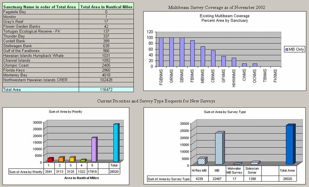
3 Interim Report September 2004 Background: Since 2002, with the signing of a Memorandum of Agreement, the USGS has been collaborating with the NMSP in the development of a strategy for seabed mapping in the national marine sanctuaries. Additional critical assistance and support in this effort has been provided by the UNH Center for Coastal and Ocean Mapping/Joint Hydrography Center, and the Office of Coast Survey. The goal of the strategy is to provide seabed maps of the national marine sanctuaries and Northwestern Hawaiian Islands Coral Reef Ecosystem Reserve that will effectively support management, research, monitoring, education, outreach, and enforcement at these sites. The identification of the mapping priorities across the NMS System and at each site is necessary to guide and inform the collection, analysis, ground-truthing, and visualization of these data, as well as to effectively and efficiently coordinate with other offices and programs within the Integrated Ocean Mapping (IOM) initiative, in mapping activities across the Agency. UNH Workshop: Findings and Recommendations: In order to address the first element of the USGS/ MOU, a workshop was held at the University of New Hampshire in November of 2002, hosted by the Center for Coastal and Ocean Mapping/Joint Hydrography Center. This workshop brought together experts from the Center, USGS, and the academic community with NMSP managers and scientists to identify the critical elements of appropriate and useful seabed maps, and how to best acquire such data and maps. A consensus was reached by the participants at the workshop that the Sanctuaries should be mapped completely, 100% coverage, using either acoustic or optical swath mapping technologies (multibeam, sidescan sonar, LIDAR), to a resolution of 10 s of meters horizontal and 10 s of centimeters vertical, which was generally consistent with the resolution of existing multibeam maps available at a few of the sites. The backscatter data, which provides some measure of bottom hardness (mud or rock, for example) must be interpreted and groundtruthed (according to a methodology to be developed none currently exists) using regional habitat characterization schemes adopted by consensus within that region, but having elements which allow intercomparability among the schemes selected). Areas within each sanctuary will be identified and prioritized for higher resolution mapping (around horizontal 1 m or optical resolution that which can only be mapped using video data, or more advanced technology such as laser line scan or some recent advancements in multibeam technology). National priorities will be identified for base and higher resolution mapping, established on the basis of whether sites already meet the 100% coverage goal, and sites and areas within those sites where significant management needs (zone monitoring, designated research areas, impact assessment, etc.) are driving the collection of this information.
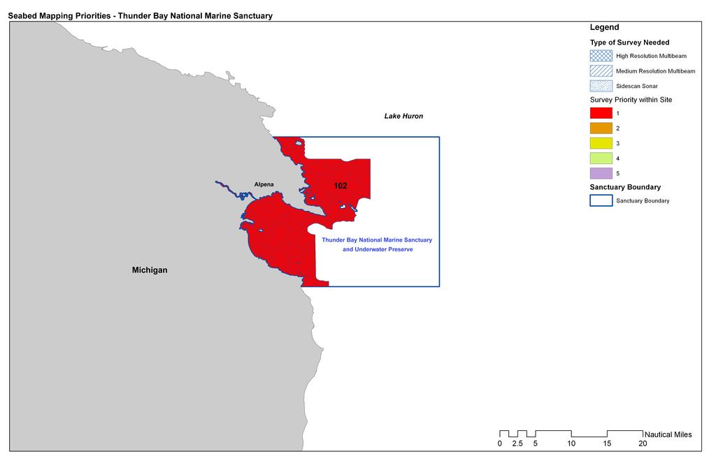
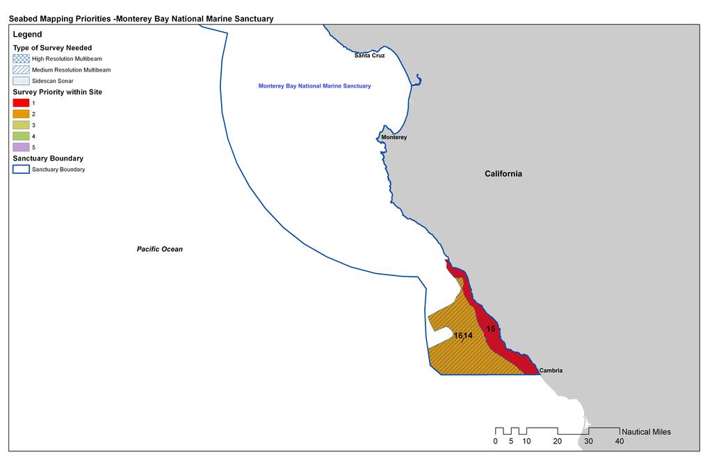
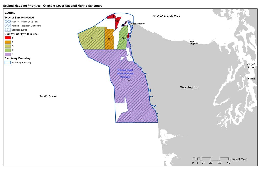
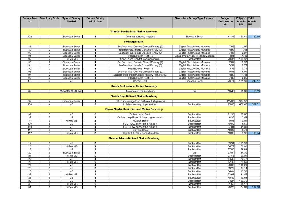
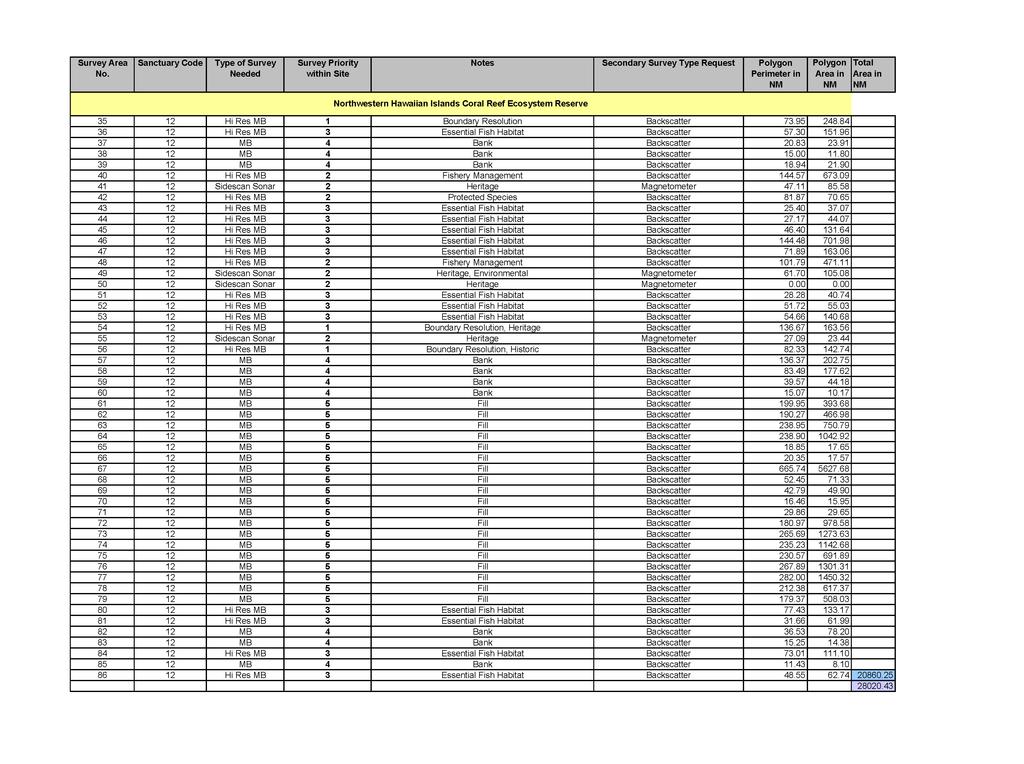
4 Identifying Priorities: Existing seabed mapping data and metadata (where available) were collected for each NMS site (and the NWHICRER) and converted to GIS data layers, providing a comprehensive catalogue of existing seabed mapping information available for each site (except the Monitor National Marine Sanctuary.) Although most of the current survey data is from s archives, it should be noted that other sources such as USGS, and University of Southern California data collected within sanctuaries were included. The sites were then divided into cells of 1 sq. nmi. and sanctuary site personnel were asked to identify priority areas to be mapped both at medium-resolution and high-resolution, or with side scan sonar. Requests for other types of seabed mapping techniques were also considered where provided by site staff. This information was collected and summarized in the accompanying map folio. Within each prioritized polygon is a number that is connected to specific information in the spreadsheets following the maps. Definitions of some of the different types of sonar data collection techniques follow this section. An example of existing mapped areas for Channel Islands National Marine Sanctuary is included. All known recent surveys (as of Aug ) have been included in the assessment of currently available seabed mapping data. The results of this preliminary effort should not be considered final. The maps shown in this folio represent the first draft of sanctuary site proposed surveys. These maps and descriptive text will be provided to the site staff for review and revision. It should also be noted that this is an evolving document that will be periodically updated for new survey requirements, completions, and priority changes. Next Steps: A working session is being planned at the UNH CCOM/JHC in the Fall of 2004, involving participants from NMSP, USGS, OCS, and others, to take the mapping priorities information and identify the funding, ship-time, and other asset requirements that will be required for the NMSP to implement this seabed mapping strategy. These assessments are made based on needs requirements, area covered, complexity of the survey area, depth divisions, staff availability, data processing, and equipment/platform requirements. This requirements document should be completed within two months of the completion of the working session, and be distributed to partners within and USGS involved in the Integrated Ocean Mapping collaboration. The US Geological Survey, /National Marine Sanctuary Program's Seabed Mapping Initiative: Annual Report can be found at : For additional information, contact: Brad Barr, NMS Program Point of Contact, JSBMI (Brad.Barr@noaa.gov) Christine Taylor, Lead, Mapping Priorities Project (Christine.Taylor@noaa.gov)
 to the seafloor and back to the transducer.")

5 Definition of terms: Multibeam sonar & backscatter Most modern multibeam systems are capable of measuring both sound reflectance strength (known as backscatter and is similar to side scan sonar), and the depth, which is obtained by recording the time for the acoustic signal to travel from the transmitter (transducer) to the seafloor and back to the transducer. Multibeam sonars are generally attached to a vessel, rather than being towed like a side scan sonar. Therefore, the coverage area and data resolution on the seafloor is dependent on the depth of the water, which is typically two to four times the water depth. The fact that they are attached to the vessel also allows for precise location information for each individual sounding collected by the system. Multibeam Survey Flower Garden Banks NMS, James Gardner, USGS There are many types of systems available. Each system is manufactured to survey particular ranges of depths. Most shallow water systems do not survey deep water areas well, if at all (depending on depth), and vice versa. The main disadvantage of multibeam is the inability to position the transducer close to the seafloor in deeper waters as is possible with side scan sonar. Because the transducer is not being towed it can not be lowered or raised in order to obtain high resolution data across the entire seafloor being mapped. There are new AUV mounted systems that can be used and they are currently being tested by the National Underwater Research Program (NURP). Midwater multibeam is a multibeam system for measuring biomass in the water column. This technology is still experimental but has shown positive results for measuring fish and other biomass in the water column at the midwater trawl levels. NMFS is the most common user of midwater multibeam data. However, the NMSP may be able to utilize this type of data with the help of NMFS and the vessels outfitted primarily for fisheries research. An assessment of the types of and quantities of the animals living within and outside sanctuary waters Midwater and Seabed Multibeam Data (Center for Coastal Ocean Mapping Joint Hydrographic Center)

6 can provide the program with data that may help assess whether or not sanctuary special protection areas are working and are correctly placed. In addition to the multibeam data collection, fish trawl data must also be simultaneously collected in order to determine the types of animals that are being recorded. It is thought that this type of system may be better than traditional trawl data alone because the multibeam system will survey a wide swath to either side and below the vessel. These areas are only partially covered by the trawl nets, and are thought to be the regions where animals may typically flee from the ship noise and turbulence. Side scan sonar is a specialized sonar system for searching and detecting objects on the seafloor. Like other sonars, a side scan transmits sound energy and analyzes the return signal (echo) that has bounced off the seafloor or other objects. In a side scan, sidelooking transducers transmit energy that is formed into the shape of a fan that sweeps the seafloor from directly under the towfish to either side, typically to a distance of 100 meters. The strength of the return echo is continuously recorded creating a "picture" of the ocean bottom where objects that protrude from the bottom create a dark image (strong return) and shadows from these objects are light areas (little or no return). While the shape of the seafloor and objects on it can be well depicted, most side scan systems can not provide any depth information. The advantage of side scan sonar over multibeam surveys is its ability to resolve small details in very deep water. While multibeam is usually hull-mounted, a side scan sonar is usually towed below and behind a ship. This allows the sonar to get as close to the target as is needed. The disadvantage of the side scan sonars is that they do not provide depth information, and are not precisely geo-rectified because the towfish cannot be tracked underwater with a GPS system so that only estimated USS Monitor Side Scan Survey s Hydrographic positions can be obtained. This Survey Division type of survey is particularly good for shipwreck and hazards to navigation surveys at depth, or for getting a closer view of known depth and backscatter locations for purposes of habitat or geologic classification. Used in conjunction with multibeam surveys and ground truthed data such as video or sediment surveys, this technology can be very useful for detailed bottom classification.

7 Example of Existing Bathymetry Assessment - Channel Islands NMS
8

9

10

11
12

13
14

15
16
17
18
19 The following table links to the numbered polygons on the maps.
20

21
22
23
NOAA/University of New Hampshire Joint Hydrographic Center & Center for Coastal and Ocean Mapping. MAPPS Summer Conference July 23, 2013
 NOAA/University of New Hampshire Joint Hydrographic Center & Center for Coastal and Ocean Mapping MAPPS Summer Conference July 23, 2013 07/23/2013 2 07/23/2013 3 Center Goals To be a world leader in the
Kyle Griebel NRS 509 Dr. August & Dr. Wang GIS and remote sensing in Seafloor mapping
 GIS and remote sensing in Seafloor mapping Introduction to seafloor mapping Seafloor maps have a wide variety of uses for scientists and coastal planning needs. Some of these uses include biological assessment
12/11/2013& egm502 seafloor mapping
 egm502 seafloor mapping lecture 13 multi-beam echo-sounders The majority of the current charts of the ocean floors have been produced from single beam echo-sounder data. Even though these data have been
Current Hydrographic Projects at BSH
 7 th Workshop Seabed Acoustics, Rostock, November 19/20, 2015 P01-1 Current Hydrographic Projects at BSH Thomas Dehling Federal Maritime and Hydrographic Agency (BSH) Germany Contact Address Website BSH
Smart Survey Approach: Multibeam Echosounder and Integrated Water Column Data as an Added Value for Seep Hunting
 Smart Survey Approach: Multibeam Echosounder and Integrated Water Column Data as an Added Value for Seep Hunting HYDRO 2016 8 November 2016 Marco Filippone Introduction, Multibeam Sonars & water column
Topic: Bathymetric Survey Techniques. (a) Single-beam echo-sounders (SBES) (b) Multi-beam echo-sounders (MBES)
 Single-beam echo-sounders (SBES) (b) Multi-beam echo-sounders (MBES)") Topic: Bathymetric Survey Techniques (a) Single-beam echo-sounders (SBES) (b) Multi-beam echo-sounders (MBES) Bathymetry is the measurement of water depths - bathymetry is the underwater equivalent of
Topic: Bathymetric Survey Techniques (a) Single-beam echo-sounders (SBES) (b) Multi-beam echo-sounders (MBES) Bathymetry is the measurement of water depths - bathymetry is the underwater equivalent of
Introduction to Acoustic Remote Sensing and Seafloor Mapping (AE4-E13) May 19, 2010
 May 19, 2010") Introduction to Acoustic Remote Sensing and Seafloor Mapping (AE4-E13) May 19, 2010 1 Delft Vermelding Institute onderdeel of Earth organisatie Observation and Space Systems Why Acoustic Remote Sensing?
Introduction to Acoustic Remote Sensing and Seafloor Mapping (AE4-E13) May 19, 2010 1 Delft Vermelding Institute onderdeel of Earth organisatie Observation and Space Systems Why Acoustic Remote Sensing?
SW Florida Escarpment Mapping Area
 Overview NOAA s Okeanos Explorer (EX) Program plans to conduct systematic mapping and telepresence-enabled ROV explorations in the Gulf of Mexico during Spring 2014. In 2011, the EX conducted mapping operations
GG710 Remote Sensing in Submarine Environments Sidescan Sonar
 GG710 Remote Sensing in Submarine Environments Sidescan Sonar Harold Edgerton, a professor of electrical engineering at the Massachusetts Institute of Technology, developed sidescan sonar technology for
Northwestern Hawaiian Islands Coral Reef Research Partnership: Ocean Mapping, Ecosystem Threats, and Information Management
 Northwestern Hawaiian Islands Coral Reef Research Partnership: Ocean Mapping, Ecosystem Threats, and Information Management Malia Chow Papahanaumokuakea Marine National Monument National Oceanic and Atmospheric
Acoustic seafloor mapping systems. September 14, 2010
 Acoustic seafloor mapping systems September 14, 010 1 Delft Vermelding Institute onderdeel of Earth organisatie Observation and Space Systems Acoustic seafloor mapping techniques Single-beam echosounder
Habitat Mapping in The Hauraki Gulf Marine Park. Dan Breen
 Habitat Mapping in The Hauraki Gulf Marine Park Dan Breen Outline 1. Intro Habitat mapping 2. Coastal marine habitats and marine protected areas in the New Zealand Territorial Sea: a broad scale gap analysis
STATISTICAL ANALYSIS FOR AUTOMATED SEEP EXTRACTION IN GIS
 STATISTICAL ANALYSIS FOR AUTOMATED SEEP EXTRACTION IN GIS Presented by Pamela Kanu, GISP ESRI USER CONFERENCE JULY 2017 SEEPS Seeps are natural gas and crude oil that enter the ocean through cracks and
Kate Labrum
 2010-2011 Bren Group Project Proposal Boats, Whales, & the Santa Barbara Channel: An economic analysis & policy options for reducing the risk of vessel strikes to endangered whales Bren Student Proposers
NEW SEAFLOOR INSTALLATIONS REQUIRE ULTRA-HIGH RESOLUTION SURVEYS
 NEW SEAFLOOR INSTALLATIONS REQUIRE ULTRA-HIGH RESOLUTION SURVEYS Donald Hussong (Fugro Seafloor Surveys, Inc.) dhussong@fugro.com Fugro Seafloor Surveys, Inc., 1100 Dexter Avenue North (Suite 100), Seattle,
NOAA Seafloor Mapping in the Pacific Islands Region
 NOAA Seafloor Mapping in the Pacific Islands Region NOAA Coral Reef Ecosystem Division Pacific Island Fisheries Science Center Mission Statement Conduct research that provides scientific information and
Sister Sanctuaries: Linking the Science and Management of Coral Reefs in Cuba and the U.S.
 Sister Sanctuaries: Linking the Science and Management of Coral Reefs in Cuba and the U.S. Memorandum of Understanding on Cooperation in the Conservation and Management of Marine Protected Areas Seventh
Marine Geomorphology as a Determinant for Essential Life Habitat III
 Marine Geomorphology as a Determinant for Essential Life Habitat III marinecoastalgis.net/aag08 10:10 Dawn Wright, Oregon 10:30 Will McClintock, California 10:50 Daniel Sampson, Massachusetts 11:10 Gary
Marine Spatial Planning: A Tool for Implementing Ecosystem-Based Management
 Marine Spatial Planning: A Tool for Implementing Ecosystem-Based Management Steven Murawski, Ph.D., Ecosystem Goal Team Lead National Oceanic and Atmospheric Administration NOAA November 16, 2009 1 To
Multibeam Mapping of Feature Rich Seafloor in the U.S. Pacific Remote Islands Marine National Monument and on Mendocino Ridge off the California Coast
 University of New Hampshire University of New Hampshire Scholars' Repository Center for Coastal and Ocean Mapping Center for Coastal and Ocean Mapping 3-2015 Multibeam Mapping of Feature Rich Seafloor
FINMARINET: Inventories and Planning for the Marine Natura 2000 Network in Finland. A.2 Geological inventories of the seafloor Final Report
 LIFE07 NAT/FIN/000151 FINMARINET: Inventories and Planning for the Marine Natura 2000 Network in Finland A.2 Geological inventories of the seafloor Final Report Geological Survey of Finland, GTK 1. Introduction
Benthic habitat mapping using multibeam sonar
 Benthic habitat mapping using multibeam sonar Iain M. Parnum 1, Alexander Gavrilov 1 and Justy Siwabessy 2 1. Centre for Marine Science and Technology, Curtin University, Perth, Australia 2. Geoscience
Future Ocean Floor Mapping: Ocean Stewardship & Initial Industry Contributions. U.S Hydro Galveston, TX March 23, 2017 David Millar - Fugro
 Future Ocean Floor Mapping: Ocean Stewardship & Initial Industry Contributions U.S Hydro 2017 - Galveston, TX March 23, 2017 David Millar - Fugro Presentation Outline The Need for Ocean Mapping GEBCO GEBCO
A National Outer Continental Shelf Sand / Sediment Inventory
 A National Outer Continental Shelf Sand / Sediment Inventory Sand Resource Areas Lease Areas Lora Turner December 15, 2016 Restoring and Protecting Our Nation s Coasts through Stewardship of OCS Resources
Coastal Response Research Center. Nancy Kinner University of New Hampshire (UNH) Michele Jacobi NOAA ORR. September 27, 2007
 Michele Jacobi NOAA ORR. September 27, 2007") Coastal Response Research Center Nancy Kinner University of New Hampshire (UNH) Michele Jacobi NOAA ORR September 27, 2007 1 Coastal Response Research Center (CRRC) CRRC is partnership between NOAA s Office
Coastal Response Research Center Nancy Kinner University of New Hampshire (UNH) Michele Jacobi NOAA ORR September 27, 2007 1 Coastal Response Research Center (CRRC) CRRC is partnership between NOAA s Office
Evaluating the USACE's NCMP for NOAA charting operations
 University of New Hampshire University of New Hampshire Scholars' Repository Center for Coastal and Ocean Mapping Center for Coastal and Ocean Mapping 8-2013 Evaluating the USACE's NCMP for NOAA charting
Regional and Nearshore Bathymetry of American Samoa: Implications for Tsunami Run-Up and Public Awareness
 Regional and Nearshore Bathymetry of American Samoa: Implications for Tsunami Run-Up and Public Awareness Presentation U21D-07 2009 AGU Fall Meeting San Francisco Authors Dawn Wright Dept. of Geosciences,
Name Class Date. The ocean floor has varied and distinct surfaces much like those found on land.
 6 Explore the Seafloor BigIdeas The ocean floor has varied and distinct surfaces much like those found on land. Satellites orbiting Earth, as well as sonar technology, are used to map the seafloor. The
Seabed 2030: A Call to Action
 Seabed 2030: A Call to Action Rear Adm. Shepard Smith NOAA Office of Coast Survey shep.smith@noaa.gov Introduction Many people like me start speeches about mapping the ocean with we know more about the
OCEANOGRAPHIC DATA MANAGEMENT
 OCEANOGRAPHIC DATA MANAGEMENT Presented to: Environmental Disaster Data Management Meeting Russ Beard Director, National Coastal Data Development Center Interim Science Coordinator, Gulf Restoration Council
The Science of Coastal and Marine Spatial Planning A Workshop for Oregon Academic Faculty
 The Science of Coastal and Marine Spatial Planning A Workshop for Oregon Academic Faculty November 29 30, 2011 Oregon State University Lisa DeBruyckere, Coordinator West Coast Governors Agreement on Ocean
Mapping of marine habitats in shallow coastal areas in Denmark
 6 th Workshop Seabed Acoustics, Rostock, November 14/15, 2013 P11-1 Mapping of marine habitats in shallow coastal areas in Denmark Dr. Zyad Al-Hamdani Geological Survey of Denmark and Greenland - GEUS
Data and Information Management. UK All Energy 22 nd May Presented by Leo James
 Data and Information Management UK All Energy 22 nd May 2013 Presented by Leo James Strategic Development Plans Observations at the outset Data and information management and dissemination: company or
GROUNDFISH AMENDMENT 28 REGULATION DEVELOPMENT UPDATE
 Agenda Item I.2.a NMFS Report 1 September 2018 GROUNDFISH AMENDMENT 28 REGULATION DEVELOPMENT UPDATE In drafting regulations for the Council s final preferred alternative for Amendment 28, recommended
Charleston to Woods Hole R/V Armstrong Transit: Atlantic Margin Upper Slope Fluid Flow Features, Seafloor and Water Column Surveys
 Charleston to Woods Hole R/V Armstrong Transit: Atlantic Margin Upper Slope Fluid Flow Features, Seafloor and Water Column Surveys Contacts: Carolyn Ruppel (US Geological Survey, cruppel@usgs.gov, 508-457-2339)
Earth in 2-D, 3-D & 4-D
 Earth in 2-D, 3-D & 4-D We will consider the scientific tools and techniques used to map surface features, reconstruct the layered structure of Earth, and interpret Earth history, including the origin
Changes in bottom morphology of Long Island Sound near Mount Misery Shoal as observed through Repeated Multibeam Surveys
 Changes in bottom morphology of Long Island Sound near Mount Misery Shoal as observed through Repeated Multibeam Surveys Laurie A. Zaleski Laurie.Zaleski@msrc.sunysb.edu Roger D. Flood rflood@notes.cc.sunysb.edu
Current and Future Technology Applications for Coastal Zone Management. Bruce K. Carlisle, Acting Director Office of Coastal Zone Management
 Current and Future Technology Applications for Coastal Zone Management Bruce K. Carlisle, Acting Director Office of Coastal Zone Management The Massachusetts Coastal Zone Management Program Approved in
University of New Hampshire Scholars' Repository
 University of New Hampshire University of New Hampshire Scholars' Repository Center for Coastal and Ocean Mapping Center for Coastal and Ocean Mapping 3-2009 Environmental Response Management Application
Biogeographic Approach to Coastal Assessments & Spatial Planning
 NOAA s Biogeographic Approach to Coastal Assessments & Spatial Planning Mark E. Monaco Mark.Monaco@noaa.gov Center for Coastal Monitoring and Assessment http://ccma.nos.noaa.gov/about/biogeography Biogeography
Benthic habitat mapping: a synopsis of methodologies and approaches. Dr. Craig Brown University of Ulster
 Benthic habitat mapping: a synopsis of methodologies and approaches Dr. Craig Brown University of Ulster Technological advances in remote sensing Insitu sampling Improving technology Single beam acoustics/video
Fine-scale Survey of Right and Humpback Whale Prey Abundance and Distribution
 DISTRIBUTION STATEMENT A: Approved for public release; distribution is unlimited. Fine-scale Survey of Right and Humpback Whale Prey Abundance and Distribution Joseph D. Warren School of Marine and Atmospheric
Ultrasonic Measuring System for Deposition of Sediments in Reservoirs
 MECAHITECH 11, vol. 3, year: 011 Ultrasonic Measuring System for Deposition of Sediments in Reservoirs M. Mărgăritescu* 1, A. Moldovanu * 1, P. Boeriu *, A.M.E. Rolea* 1 * 1 National Institute of Research
Offshore Operations and Project Execution Geophysical Site Surveys
 Offshore Operations and Project Execution Geophysical Site Surveys Chris Almond Senior Geophysicist Fugro Survey Limited 22/04/2015 Presentation Summary: Office-based Personnel Project Awarded Pre Offshore
Digital Elevation Model of Tutuila, American Samoa: Procedures, Data Sources, and Analysis
 Digital Elevation Model of Tutuila, American Samoa: Procedures, Data Sources, and Analysis Prepared for the National Tsunami Hazard Mitigation Program (NTHMP) by the NOAA National Geophysical Data Center
Lessons Learned from Fish Spawning Reef Restoration in the St. Clair Detroit River System. Photo Credit: Adam Lintz
 Lessons Learned from Fish Spawning Reef Restoration in the St. Clair Detroit River System Photo Credit: Adam Lintz Outline and Presenters Jennifer Read, University of Michigan Water Center Introduction
Progress Report (Since February, 2014)
") CONTENT Progress Report (Since February, 2014) Results Achieved Methods Used Questions Asked/ Issues Encountered Drafted detailed matrix on Trial Accounts with identified ecosystem pressure, services and
CONTENT Progress Report (Since February, 2014) Results Achieved Methods Used Questions Asked/ Issues Encountered Drafted detailed matrix on Trial Accounts with identified ecosystem pressure, services and
NEEA Refresh aka 3D Nation Requirements and Benefits Study. Allyson Jason, Carol Ostergren, Xan Fredericks and Lou Driber November 9, 2017
 + NEEA Refresh aka 3D Nation Requirements and Benefits Study Allyson Jason, Carol Ostergren, Xan Fredericks and Lou Driber November 9, 2017 + 2 Study Context Background The National Enhanced Elevation
GEOPHYSICAL TECHNIQUES FOR MARITIME ARCHAEOLOGICAL SURVEYS. Abstract
 GEOPHYSICAL TECHNIQUES FOR MARITIME ARCHAEOLOGICAL SURVEYS Mark Lawrence, Wessex Archaeology, Salisbury, UK, Ian Oxley, English Heritage, Portsmouth, UK, C. Richard Bates, University of St. Andrews, St.
Recent developments in multi-beam echo-sounder processing at the Delft
 Recent developments in multi-beam echo-sounder processing at the Delft University of Technology Prof. Dr. Dick G. Simons Acoustic Remote Sensing Group, Faculty of Aerospace Engineering, Delft University
Continuous Monitoring of Fish Population and Behavior by Instantaneous Continental-Shelf-Scale Imaging with Ocean-Waveguide Acoustics
 Continuous Monitoring of Fish Population and Behavior by Instantaneous Continental-Shelf-Scale Imaging with Ocean-Waveguide Acoustics PI: Prof. Nicholas C. Makris Massachusetts Institute of Technology
Arctic Hydrographic Adequacy an Update
 Arctic Hydrographic Adequacy an Update Lt Cmd. Samuel F. Greenaway 1 and Amber Batts 1,2 1. NOAA Office of Coast Survey Development Lab, Hydrographic Systems & Technology Branch, Silver Spring, Maryland,
Seabed knowledge In support of UN SDGs
 Seabed knowledge In support of UN SDGs Evert Flier Fiskerifaglig forum 2. november 2017 Hydrography & small scale fishing Hydrography in Transition Serving the Maritime Community Hydrography in Transition
IODP Science Evaluation Panel: Guidelines and Rationale for Site Characterization Data (Revised: August 2013)
") Site Characterization Data Guidelines IODP Science Evaluation Panel: Guidelines and Rationale for Site Characterization Data (Revised: August 2013) This document outlines the method and rationale for data
Site Characterization Data Guidelines IODP Science Evaluation Panel: Guidelines and Rationale for Site Characterization Data (Revised: August 2013) This document outlines the method and rationale for data
Creating A-16 Compliant National Data Theme for Cultural Resources
 Creating A-16 Compliant National Data Theme for Cultural Resources Cultural Resource GIS Facility National Park Service John J. Knoerl Deidre McCarthy Paper 169 Abstract OMB Circular A-16 defines a set
14 th NIOHC, Myanmar National Report MYANMAR NAVAL HYDROGRAPHIC CENTRE (MNHC) NATIONAL REPORT HYDROGRAPHIC DEPARTMENT, ROYAL THAI NAVY-HDRTN
 NATIONAL REPORT HYDROGRAPHIC DEPARTMENT, ROYAL THAI NAVY-HDRTN") 14 th NIOHC, Myanmar National Report MYANMAR NAVAL HYDROGRAPHIC CENTRE (MNHC) NATIONAL REPORT 14 th NORTH INDIAN OCEAN HYDROGRAPHIC COMMISSION CONFERENCE HYDROGRAPHIC DEPARTMENT, ROYAL THAI NAVY-HDRTN
14 th NIOHC, Myanmar National Report MYANMAR NAVAL HYDROGRAPHIC CENTRE (MNHC) NATIONAL REPORT 14 th NORTH INDIAN OCEAN HYDROGRAPHIC COMMISSION CONFERENCE HYDROGRAPHIC DEPARTMENT, ROYAL THAI NAVY-HDRTN
APPLICATION FOR THE CONSENT TO CONDUCT MARINE SCIENTIFIC RESEARCH IN AREAS UNDER NATIONAL JURISDICTION OF THE UNITED KINGDOM
 APPLICATION FOR THE CONSENT TO CONDUCT MARINE SCIENTIFIC RESEARCH IN AREAS UNDER NATIONAL JURISDICTION OF THE UNITED KINGDOM 1. General information Date: 27 th January 2011 1.1 Cruise name and/or number:
Unit 6: The Sea Floor
 Unit 6: The Sea Floor Turn to Page 62 in Introduction to the World s Oceans Study the bathymetric chart What features do you see? How do the Atlantic and Pacific Oceans differ? What do you think accounts
The Arctic - A New Frontier The geological, environmental and engineering challenges for submarine telecommunication cables
 The Arctic - A New Frontier The geological, environmental and engineering challenges for submarine telecommunication cables Ryan Wopschall 5 September 2013 Oceanology International China, Shanghai Fugro
BI 101: Marine Biology
 WELCOME BI 101: Marine Biology Contact Info 1. Full Name 2. Student I.D. Number 3. Major 4. Email address 5. Preferred phone contact 6. Have you taken any other BI 101 courses at LBCC? 7. Why did you decide
Summary Description Municipality of Anchorage. Anchorage Coastal Resource Atlas Project
 Summary Description Municipality of Anchorage Anchorage Coastal Resource Atlas Project By: Thede Tobish, MOA Planner; and Charlie Barnwell, MOA GIS Manager Introduction Local governments often struggle
Characterization of the Nigerian Shoreline using Publicly-Available Satellite Imagery
 University of New Hampshire University of New Hampshire Scholars' Repository Center for Coastal and Ocean Mapping Center for Coastal and Ocean Mapping 1-2014 Characterization of the Nigerian Shoreline
Chapter Overview. Bathymetry. Measuring Bathymetry. Measuring Bathymetry
 CHAPTER 3 Marine Provinces Chapter Overview The study of bathymetry determines ocean depths and ocean floor topography. Echo sounding and satellites are efficient bathymetric tools. Most ocean floor features
Map shows 3 main features of ocean floor
 Map shows 3 main features of ocean floor 2017 Pearson Education, Inc. Chapter 3 Marine Provinces 2017 Pearson Education, Inc. 1 Chapter 3 Overview The study of bathymetry determines ocean depths and ocean
Underwater platforms and photographic techniques
 Underwater platforms and photographic techniques Underwater platforms Robotic vehicles are in use for seafloor surveys aleady since the late 1960's s in deep water archaeology. Submersible technology (human
Multiple methods, maps, and management applications: purpose made maps in support of Ocean Management. Craig J. Brown McGregor GeoScience Ltd.
 Multiple methods, maps, and management applications: purpose made maps in support of Ocean Management Craig J. Brown McGregor GeoScience Ltd. International workshop on seabed mapping methods and technology,
Developing a Seabed Resurvey Strategy: A GIS approach to modelling seabed changes and resurvey risk
 Developing a Seabed Resurvey Strategy: A GIS approach to modelling seabed changes and resurvey risk A. M. Bakare, J. G. Morley, R. R. Simons Department of Geomatic Engineering, University College London,
USGS National Geospatial Program Understanding User Needs. Dick Vraga National Map Liaison for Federal Agencies July 2015
 + USGS National Geospatial Program Understanding User Needs Dick Vraga National Map Liaison for Federal Agencies July 2015 + Topics 2 Background Communities of Use User Surveys National Map Liaisons Partnerships
Joint Hydrographic Center, National Oceanic and Atmospheric Administration, Durham, NH 03824, USA
 Future directions in hydrography using satellite-derived bathymetry Shachak Pe eri 1, Christopher Parrish 2, 3, Lee Alexander 1, Chukwuma Azuike 1, Andrew Armstrong 1,3 and Maryellen Sault 2 1 Center for
Your web browser (Safari 7) is out of date. For more security, comfort and the best experience on this site: Update your browser Ignore
 is out of date. For more security, comfort and the best experience on this site: Update your browser Ignore") Your web browser (Safari 7) is out of date. For more security, comfort and the best experience on this site: Update your browser Ignore BATHYMETRY For the complete encyclopedic entry with media resources,
Your web browser (Safari 7) is out of date. For more security, comfort and the best experience on this site: Update your browser Ignore BATHYMETRY For the complete encyclopedic entry with media resources,
Bathymetry Data and Models: Best Practices
 Bathymetry Data and Models: Best Practices Barry Eakins & Lisa Taylor The NOAA National Geophysical Data Center Over 600 data types - from the core of the Earth to the surface of the Sun NGDC Bathymetry
Seafloor Mapping and Research Activities
 Seafloor Mapping and Research Activities Marco D Emidio Mississippi Mineral Resources Institute Advisory Board Meeting Jackson, MS February 12, 2015 Outline 1. Define your Goal/Target What do you want
Aarno Kotilainen, The Geological Survey of Finland Anu Reijonen, The Geological Survey of Finland. Open
 Title BALANCE Cruise Report: The Archipelago Sea, 18/7 18/8 2006 BALANCE Interim Report No. 6 Editors Aarno Kotilainen, The Geological Survey of Finland Anu Reijonen, The Geological Survey of Finland Date
COVERAGE-Sargasso Sea
 COVERAGE-Sargasso Sea A Collaborative Project between NASA and the Sargasso Sea Commission Dr. Vardis Tsontos Dr. Jorge Vazquez NASA Jet Propulsion Laboratory, California Institute of Technology UN-HQ
Sediment classification from multibeam backscatter images using simple histogram analysis
 Sediment classification from multibeam backscatter images using simple histogram analysis Rozaimi Che Hasan 1,2, Mohd Razali Mahmud 3 and Shahrin Amizul Shamsudin 1 1 UTM Razak School of Engineering and
Technologies for sea bottom inhabitants' monitoring and Integral Costal Zones Management. Example of the Kandalaksha Bay, White Sea
 Technologies for sea bottom inhabitants' monitoring and Integral Costal Zones Management. Example of the Kandalaksha Bay, White Sea Mikhail Tokarev, Roman Pevzner Transfer Technology Office of Lomonosov
Applied Geoscience and Technology Division SOPAC. Joy Papao, Risk Information Systems Officer
 Joy Papao, Risk Information Systems Officer Secretariat of the Pacific Community SPC 22 Pacific Island States Head office in Noumea, New Caledonia 2 Regional offices (Pohnpei and Honiara) 600 staff 9 Technical
Vision: The National Oceanography Centre will, by 2015, be recognised as the world-leading Centre for integrated ocean sciences and technology".
 National Oceanography Centre from coast to deep ocean Waterfront Campus, Southampton Vision: Joseph Proudman Building, Liverpool The National Oceanography Centre will, by 2015, be recognised as the world-leading
Cruise Report YK10-06
 Cruise Report YK10-06 (R/V Yokosuka) Site Surveys for drilling projects of IODP at the Kumano-nada and the northern Izu-Bonin arc June 13 20, 2010 Center for Deep Earth Exploration (CDEX) Japan Agency
GEOPHYSICAL SURVEYS: What are Seismic Surveys and How are They Done?
 GEOPHYSICAL SURVEYS: What are Seismic Surveys and How are They Done? Marine Geophysical Exploration Purpose Image the subsurface Evaluate the acreage Identify potential hydrocarbon accumulations Reducing
WP. 4 Detection and characterization of CWA dumpsites. Zygmunt Klusek Ulf Olsson
 WP. 4 Detection and characterization of CWA dumpsites Zygmunt Klusek Ulf Olsson Stockholm 02.03.2013 Zygmunt Klusek & Ulf Olsson WP. 4 Detection and characterization of CWA dumpsites 0.2.03.2013 This page
Confidence Assessment Scoring System
 Confidence Assessment Scoring System Confidence field Confidence group Confidence question Comments Remote sensing data collection RemoteTechnique Were the techniques used appropriate for the ground type?
GEOGRAPHIC INFORMATION SYSTEMS Session 8
 GEOGRAPHIC INFORMATION SYSTEMS Session 8 Introduction Geography underpins all activities associated with a census Census geography is essential to plan and manage fieldwork as well as to report results
The route towards a new GEBCO grid
 The route towards a new GEBCO grid Pauline Weatherall, GEBCO Digital Atlas Manager British Oceanographic Data Centre (BODC) GEBCO TSCOM/SCRUM meeting, Monaco, October 2012 The route towards a new GEBCO
Storm Response Surveying with Phase- Measuring Bathymetric Sidescan Sonar
 Storm Response Surveying with Phase- Measuring Bathymetric Sidescan Sonar Kevin Jerram and Val Schmidt Center for Coastal and Ocean Mapping Durham, New Hampshire Two sunken subway cars and adjacent bedforms
Digital Elevation Model (DEM) of Sable Island Bank and adjacent areas
 of Sable Island Bank and adjacent areas") GEOLOGICAL SURVEY OF CANADA OPEN FILE 5348 Digital Elevation Model (DEM) of Sable Island Bank and adjacent areas K.J. Webb and E.L. King 2014 GEOLOGICAL SURVEY OF CANADA OPEN FILE 5348 Digital Elevation
GEOLOGICAL SURVEY OF CANADA OPEN FILE 5348 Digital Elevation Model (DEM) of Sable Island Bank and adjacent areas K.J. Webb and E.L. King 2014 GEOLOGICAL SURVEY OF CANADA OPEN FILE 5348 Digital Elevation
Socioeconomic Profile and Spatial Analysis of Fisheries in the three central California National Marine Sanctuaries
 Socioeconomic Profile and Spatial Analysis of Fisheries in the three central California National Marine Sanctuaries 23 + 30 March 2004 Charles Steinback and Astrid Scholz Outline Who we are and why we
STATEMENT OF CAPABILITY
 BELIZE MARINE CONSERVATION AND CLIMATE ADAPTATION PROJECT (MCCAP) Ministry of Forestry, Fisheries and Sustainable Development STATEMENT OF CAPABILITY Consultant for the Realignment of Boundaries and the
Autonomous Platforms for Marine Mapping and Monitoring: A UK Perspective. Dr Russell B Wynn (Head of NOC Marine Geoscience, MARS Chief Scientist)
") Autonomous Platforms for Marine Mapping and Monitoring: A UK Perspective Dr Russell B Wynn (Head of NOC Marine Geoscience, MARS Chief Scientist) Marine mapping and monitoring: an escalating problem. Policy
Autonomous Platforms for Marine Mapping and Monitoring: A UK Perspective Dr Russell B Wynn (Head of NOC Marine Geoscience, MARS Chief Scientist) Marine mapping and monitoring: an escalating problem. Policy
Bathymetry Measures the vertical distance from the ocean surface to mountains, valleys, plains, and other sea floor features
 1 2 3 4 5 6 7 8 9 10 11 CHAPTER 3 Marine Provinces Chapter Overview The study of bathymetry determines ocean depths and ocean floor topography. Echo sounding and satellites are efficient bathymetric tools.
Appendix I: Geographic Information System Data Sources
 Appendix I: Geographic Information System Data Sources Draft Environmental Impact Statement/Overseas Environmental Impact Statement Hawaii-Southern California Training and Testing TABLE OF CONTENTS...
Inspection of Waterfront Facilities Using Vessel-Based Remote Sensing Mitchell, Del Bello, Suarez
 Inspection of Waterfront Facilities Using Vessel-Based Remote Sensing Mitchell, Del Bello, Suarez American Association of Port Authorities Facilities Engineering Conference October 20-22, 2015 Waterfront
Warm Up 1: Ocean Floors LT I can explain the concept of Pangea. I can describe how Ocean Ridges form and give examples of them.
 Warm Up 1: Ocean Floors 4-18-17 LT I can explain the concept of Pangea. I can describe how Ocean Ridges form and give examples of them. Q1. How do we get a diversity of birds? Q2. How did the breeds of
Opening their Shells Getting commercial clammers involved in marine spatial planning
 Opening their Shells Getting commercial clammers involved in marine spatial planning Ed Lewandowski Coastal Communities Development Specialist University of Delaware/Delaware Sea Grant Highlights Background
Inspire Conference Istanbul, 2012 Ralf Lindgren. Inspire Conference Istanbul, 2012 Ralf Lindgren
 Background A Baltic Sea Bathymetry Database Concept and Hans Öiås Swedish Maritime Administration Hydrographic Office A national directive: The Swedish Maritime Administration shall, in cooperation with
Characteristics of Sounds Emitted During High Resolution Marine Geophysical Surveys
 CAUV/15-44 10 th Meeting of the Consultative Committee for Acoustics, Ultrasound and Vibration (CCAUV) Characteristics of Sounds Emitted During High Resolution Marine Geophysical Surveys Dr. Steven Crocker
Additional information (material for interactions and analysis chapter) to document 3/1, the PLAN BOTHNIA MSP Assessment
 to document 3/1, the PLAN BOTHNIA MSP Assessment") Co-Financed Under European Integrated Maritime Policy PLAN BOTHNIA MSP 2/2011 MSP Assessment Add 1 PLAN BOTHNIA MSP 2 Uppsala, Sweden June 14-15 2011 Agenda Item 3 PLAN BOTHNIA MSP Assessment Document
Co-Financed Under European Integrated Maritime Policy PLAN BOTHNIA MSP 2/2011 MSP Assessment Add 1 PLAN BOTHNIA MSP 2 Uppsala, Sweden June 14-15 2011 Agenda Item 3 PLAN BOTHNIA MSP Assessment Document
Adaptive Bathymetric System Mapping of Champagne Reef and Scott s Head
 Adaptive Bathymetric System Mapping of Champagne Reef and Scott s Head TRAVIS ROOF¹ ABSRACT Bathymetric maps are crucial not only for navigational purposes but also for conservation of marine environments.
GEOL- 270: Issues in Oceanography Developed by Jessica Kleiss, Lewis & Clark College
 GEOL- 270: Issues in Oceanography Developed by Jessica Kleiss, Lewis & Clark College Lab 02: Ocean floor bathymetry. Material for students to bring: A calculator A ruler Pens and pencils Objectives: Interpret
2012 FORUM OF MARINE PROTECTED AREAS IN THE MEDITERRANEAN ANTALYA, TURKEY
 2012 FORUM OF MARINE PROTECTED AREAS IN THE MEDITERRANEAN ANTALYA, TURKEY SPECIAL EVENT Challenges for Open Seas MPAs in the Mediterranean region November 27, 2012. 15h00-16H00 Slide # 1 2012 FORUM OF