Marine Spatial Planning: A Tool for Implementing Ecosystem-Based Management
|
|
|
- Tyrone Horton
- 6 years ago
- Views:
Transcription


1 Marine Spatial Planning: A Tool for Implementing Ecosystem-Based Management Steven Murawski, Ph.D., Ecosystem Goal Team Lead National Oceanic and Atmospheric Administration NOAA November 16,

2 To succeed in protecting the oceans, coasts, and Great Lakes, the United States needs to act within a unifying framework under a clear national policy, including a comprehensive, ecosystem-based framework for the long term conservation and use of our resources. President Barack Obama June 12, 2009 Creation of the Ocean Policy Task Force The Imperative for Implementing Ecosystem Based Management 2

3 EBM NOAA s View EBM is an approach that provides a comprehensive framework for marine and coastal resource decision making. In contrast to individual species or issue management, EBM considers a wider range of relevant ecological, environmental and human factors bearing on societal choices regarding resource use. Characteristics: (1) geographically specified, (2) adaptive, (3) accounts for ecosystem knowledge and uncertainties, (4) multiple simultaneous drivers, (5) strives to balance diverse societal objectives, (7) incremental, (8) collaborative 3
4 What is Coastal & Marine Spatial Planning? MSP is: A comprehensive, ecosystem-based process through which compatible human uses are objectively and transparently allocated to appropriate ocean areas to sustain critical ecological, economic and cultural services for future generations. The goals of MSP are: To maximize societal benefits of ocean uses, while minimizing impacts on ecologically sensitive areas and species and reducing conflicts between incompatible activities sharing marine locations 4

5 Coastal and Marine Spatial Planning: Implement comprehensive, integrated ecosystem-based coastal and marine spatial planning and management in the United States.
6 Key Elements to a MSP Framework A Coherent Definition of MSP Geographical Extent Regional Planning Structure Enforceability Stakeholder Participation National Goals for Plans Capacity Building Technical Support & Infrastructure
 Integrated Ocean Observing System (IOOS) Living Marine Resources Assessments")
")
 Interagency Collaboration (Federal) Tribal Interests Legal")
7 Critical NOAA Capabilities Supporting Marine Spatial Planning Enabling Capabilities Decision Support Tools Data Collection & Analysis Ecosystem Dynamics Research Integrated Ocean & Coastal Mapping (IOCM) Integrated Ocean Observing System (IOOS) Living Marine Resources Assessments Integrated Ecosystem Assessments (IEA) Human Use Patterns Data Integration 4-D Analysis Visualization Valuation Scenario Analyses Spatially Explicit Data Ecosystem Modeling Gap Analysis Balancing Biodiversity Protection & Sustainable Use NOAA Mandates Fishery Management (MSRA) Protected Species BiOps & Consultations (ESA, MMPA) National Marine Sanctuaries (NMSA) Coastal Zone Management Act (CZMA) Etc. Mandate Coordination Interjurisdictional Coordination Regional Compacts (States) Interagency Collaboration (Federal) Tribal Interests Legal Mandates & Unique Mission Convening/Coordination 7
8 Coastal & Marine Spatial Planning: Technical Requirements Enhanced Mapping & Cadastre Ocean Habitat Characterization Studies Monitoring Enforcement Hydrodynamic Models Living Marine Resource Assessments Characterization of Human Use Patterns Integrated Ecosystem Assessments (IEAs) National Marine Fisheries Service (NMFS): Stewardship of Living Marine Resources for the 21st Century 8


9 Biogeographic Assessment Approach to Support CMSP Biogeographic Data Layers Imagery Patterns of Human Use Bottom Type Bathymetry Oceanography Species Distributions (many layers) Combine Biogeographic Layers for Analysis Example Integrated Biogeographic Analyses* * Specific analyses targeted to management needs Species Richness Threatened Habitats Analytical Products to Meet Management Objectives Products to Aid Management Evaluate internal zone boundaries relative to biological resources Explore options for reducing ecosystem threats Evaluate alternative management strategies


10 Mapping and Cadastre Multibeam Bathymetry & Estimated Depths Bathymetric Position Index Enhanced Mapping Multiple Use Marine Cadastre

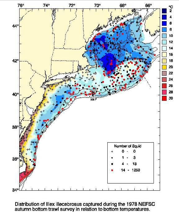
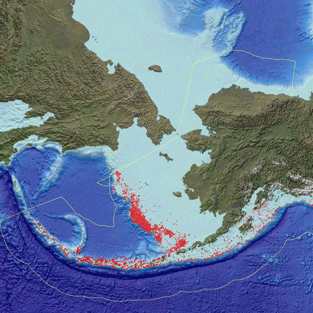
11 Living Marine Resource Assessment Alaska - Known Locations of Deep-sea Corals 1978


12 Human Use Characterization Vessel Hours = 1-8 = 9-25 = = = Vessels Hours Commercial Fishing Use

13 Hydrodynamic and Ecosystem Modeling Ecosystem Model 0m g f e d c ba Fleets 2400 Fishery Human submodel Activity Food web Community submodel Habitat Temperature, Velocity Hydrodynamic Model Hydrographic submodel Climate, oceanography Biogeochemistry Ecosystem Model
14 Coastal & Marine Spatial Planning Integrated Ecosystem Assessments CMSP Needs enabling capabilities Ecosystem dynamics research Data integration and analysis Needs decision support tools Spatially explicit ecosystem data Ecosystem modeling Scenario analysis Gap analysis Needs coordination through Regional compacts between governments Interagency collaboration at multiple levels Tribal interests IEA Provides for capability needs Understand ecosystem with models Integrate ecological and social data Provides for decision support tools Integration of spatial data 3-D ecosystem models Evaluation of tradeoffs Gap analysis through scoping process Provides coordination (e.g.) West Coast Governors Agreement supports California Current IEA Puget Sound IEA brings together local, state, federal, and tribal agencies represented in Puget Sound IEA
15 Coastal & Marine Spatial Management Current examples of activities within NOAA that support Coastal and Marine Spatial Planning Most have fairly specific goals Protected species management Sanctuaries and monuments Fisheries Offshore energy IOOS May be comprehensive Pilot project for San Pablo Bay, CA


16 Examples of CMSP: Protected Species


17 Examples of CMSP: Sanctuaries Channel Islands National Marine Sanctuary Complex Marine Spatial Planning Regime and Designation

18 Examples of MSP: Fisheries Regulations 67% of the U.S. EEZ is closed to trawling Through the Magnuson Stevens Fishery Conservation and Management Act (MSRA), NOAA can restrict all or some fishing methods from areas in order to achieve sustainable management of fished natural resources, e.g. prohibiting bottom trawling in many deep coral habitats 18

19 Examples of Non-Comprehensive CMSP: Rhode Island Ocean Special Area Management Plan reducing its carbon footprint renewable energy resources primarily offshore wind meet 15% of state s energy needs sea-level rise policy for coasts

20 Coastal & Marine Spatial Planning Oregon Planning for Wave Energy Usage in Oregon Two ocean issues designation of marine reserves siting wave energy facilities An executive order prepare plan for ocean energy development adopt as part of the Oregon Territorial Sea Plan

21 Coastal & Marine Spatial Planning California Pilot Project for San Pablo Bay, California investigate the feasibility of comprehensive zoning Prepare a management framework to minimize conflicts to maximize efficient use to address and manage current and potential cumulative impacts
22 Coastal & Marine Spatial Planning National or Regional Scale? National Top-down mandate Set the framework for integration of regional CMSP work Determine standards for data Ensure interoperability across regional efforts Regional Bottom-up driven Demonstrate ability to work across NOAA as a model to work across agencies Regions will have to organize and co-ordinate efforts Regions will have different compelling issues

23 Coastal Large Marine Ecosystems and Regional Governance Organizations of the United States Great Lakes Regional Collaboration Northeast Regiona Ocean Council West Coast Governors Agreement Mid Atlantic Regional Counc on the Ocean Southeast Region Ocean Council Gulf of Mexico Alliance 23
24 CMSP Evolving Perspectives Objectives of CMSP not yet well articulated 3rd and 4th dimensions important (not just static maps) Critical Science Ecosystem-relevant spatial planning tools Market & non-market valuation of ecosystem services Asymmetric benefits & costs Make governance using multiple sectoral statutes difficult Multi-agency problem (interagency challenge) Resource Rent Problem Integrated governance system does not exist Need to explore soft vs. hard governance & planning Conflict Resolution Mechanisms Important opportunities for Sector Stacking (e.g., aquaculture & energy). How can we promote this as a national priority?

25 spatial management an historical perspective: indications at the present time are that neither knowledge of the mechanisms of dispersion nor accuracy of data and commercial statistics is sufficient to justify the labour involved in rigorous treatment [but] the method enables working solutions to be obtained. R.J. H. Beverton and S. J. Holt, 1957
Marine Spatial Planning Leslie-Ann McGee Battelle Memorial Institute
 Marine Spatial Planning Leslie-Ann McGee Battelle Memorial Institute Rev061708 1 Marine Spatial Planning What is it? Why is it different? Where is it currently being employed? What is happening in the
Outline National legislative & policy context Regional history with ESSIM ESSIM Evaluation Phase Government Integration via RCCOM Regional ICOM Framew
 What MSP Implementation could change in the Maritimes Region Tim Hall, Regional Manager Oceans and Coastal Management Division Ecosystem Management Branch Fisheries and Oceans Canada Maritimes Region BIO
Biogeographic Approach to Coastal Assessments & Spatial Planning
 NOAA s Biogeographic Approach to Coastal Assessments & Spatial Planning Mark E. Monaco Mark.Monaco@noaa.gov Center for Coastal Monitoring and Assessment http://ccma.nos.noaa.gov/about/biogeography Biogeography
9.0 Consistency with the Magnuson-Stevens Fishery Conservation and Management Act (MSFCMA)
") 9.0 Consistency with the Magnuson-Stevens Fishery Conservation and Management Act (MSFCMA) This analysis was prepared in accordance with the requirements of the Magnuson- Stevens Fishery Conservation and
9.0 Consistency with the Magnuson-Stevens Fishery Conservation and Management Act (MSFCMA) This analysis was prepared in accordance with the requirements of the Magnuson- Stevens Fishery Conservation and
DFO Maritimes Region Update. Gulf of Maine Council - Coastal and Marine Spatial Planning (CMSP) Committee Web-Ex May 16, 2017
 Committee Web-Ex May 16, 2017") DFO Maritimes Region Update Gulf of Maine Council - Coastal and Marine Spatial Planning (CMSP) Committee Web-Ex May 16, 2017 1 National Oceans Priorities Marine Conservation Targets Oceans Protection Plan
DFO Maritimes Region Update Gulf of Maine Council - Coastal and Marine Spatial Planning (CMSP) Committee Web-Ex May 16, 2017 1 National Oceans Priorities Marine Conservation Targets Oceans Protection Plan
Marine/Maritime Spatial Planning Andrej Abramić
 Marine/Maritime Spatial Planning Andrej Abramić EcoAqua SUMMER SCHOOL: Ecosystem approach to aquaculture 26-29th of October 2015 Research and Technology to enhance excellence in Aquaculture development
LA POLÍTICA MARÍTIMA INTEGRADA
 LA POLÍTICA MARÍTIMA INTEGRADA Ministerio de Agricultura, Alimentación y Medio Ambiente Juan Luís Suárez de Vivero 2 4 de abril de 2014, Madrid INTEGRATED MARINE POLICY 1. PLANES, MARCO JURÍDICO-ADMINISTRATIVO,
National Perspectives - Portugal. Margarida Almodovar
 National Perspectives - Portugal Margarida Almodovar margarida.almodovar@mam.gov.pt from base line to the external limit of the continental shelf behind 200 miles and according to UNCLOS definitions Economic
MODELS AND TOOLS FOR GOVERNANCE OF
 Working Papers Collection No. 1/2015 MODELS AND TOOLS FOR GOVERNANCE OF THE ADRIATIC AND IONIAN SEAS www.unimc.it/maremap NATIONAL POLITICS AND EU POLITICS: THE MARITIME SPATIAL PLANNING AND INTEGRATED
NOAA Nautical Charts and Coastal and Marine Spatial Planning. Meredith Westington Chief Geographer NOAA/NOS/Office of Coast Survey
 NOAA Nautical Charts and Coastal and Marine Spatial Planning Meredith Westington Chief Geographer NOAA/NOS/Office of Coast Survey Ocean Policy Task Force What is CMSP? A comprehensive, adaptive, integrated,
The Science of Coastal and Marine Spatial Planning A Workshop for Oregon Academic Faculty
 The Science of Coastal and Marine Spatial Planning A Workshop for Oregon Academic Faculty November 29 30, 2011 Oregon State University Lisa DeBruyckere, Coordinator West Coast Governors Agreement on Ocean
SPLAN-Natura Towards an integrated spatial planning approach for Natura th January, 2017 Brussels. Commissioned by DG Environment
 SPLAN-Natura 2000 Towards an integrated spatial planning approach for Natura 2000 Commissioned by DG Environment 17 th January, 2017 Brussels V. Simeonova (Ph.D.) Drivers towards integrating Biodiversity
A TOOLKIT FOR MARINE SPATIAL PLANNING Version: 17 July, 2009
 A TOOLKIT FOR MARINE SPATIAL PLANNING Version: 17 July, 2009 NEED FOR MARINE SPATIAL PLANNING The health of marine ecosystems is declining, and use conflicts in the marine environment are increasing, in
Marine Spatial Planning (MSP): A practical approach to ecosystembased
: A practical approach to ecosystembased") Marine Spatial Planning (MSP): A practical approach to ecosystembased management Erik Olsen, Institute of Marine Research, Norway Fanny Douvere, International Oceanographic Commission Overview Why we need
Marine Spatial Planning (MSP): A practical approach to ecosystembased management Erik Olsen, Institute of Marine Research, Norway Fanny Douvere, International Oceanographic Commission Overview Why we need
MARINE SPATIAL PLANNING
 MARINE SPATIAL PLANNING Washington Uses Spatial Planning to Honor its Pacific Coast and Offshore Waters Past, Present and Future The Washington State Pacific Coast and offshore waters are diverse in both
Introduction: The Gulf of Mexico Alliance. The Gulf GAME project MERMAid and PHINS Results & Conclusions What s next? Examples
 AAG Las Vegas March 25, 2009 Introduction: Ocean governance and Ecosystem-Based Management The Gulf of Mexico Alliance Habitat Identification and Characterization The Gulf GAME project MERMAid and PHINS
Marine Geomorphology as a Determinant for Essential Life Habitat III
 Marine Geomorphology as a Determinant for Essential Life Habitat III marinecoastalgis.net/aag08 10:10 Dawn Wright, Oregon 10:30 Will McClintock, California 10:50 Daniel Sampson, Massachusetts 11:10 Gary
Country Fiche Estonia
 Country Fiche Estonia Updated October 2017 1. General information Size of internal waters (to the baseline) and territorial sea (12-nm zone from the baseline) approximately 25 200 km 2. Exclusive economic
1. Baltic SCOPE Towards coherence and cross-border solutions in Baltic Maritime Spatial Plans
 NSHC 32th Conference Explanatory Note Dublin, Ireland Item E.2 MSP 21-23 June 2016 Germany Cross border MSP for the EEZ, a case study from the Baltic Sea The Federal Maritime and Hydrographic Agency of
Ensuring Access to Marine Areas for Offshore Oil and Gas
 Ensuring Access to Marine Areas for Offshore Oil and Gas Paul Holthus Executive Director World Ocean Council paul.holthus@oceancouncil.org The international business alliance for Corporate Ocean Responsibility
MARINE SPATIAL PLANNING & MARINE CADASTRE: CHALLENGES AND ISSUES
 MARINE SPATIAL PLANNING & MARINE CADASTRE: CHALLENGES AND ISSUES Roger Longhorn Secretary General, GSDI Association rlonghorn@gsdi.org Member, IHO Marine SDI Working Group ral@alum.mit.edu Member, UNESCO
Country Fiche Estonia
 Country Fiche Estonia Deleted: October Updated May 2018 Deleted: 7 1. General information Size of internal waters (to the baseline) and territorial sea (12-nm zone from the baseline) approximately 25 200
Aquaculture Spatial Planning: The case of Greece
 Aquaculture Spatial Planning: The case of Greece Nikos Anagnopoulos Panhellenic Association for Small-Medium sized Aquaculture Enterprises Panhellenic Association for Small-Medium sized Aquaculture Enterprises
CLIMAR-III Third JCOMM Workshop on Advances in Marine Climatology 6-9 May Gdynia, Poland
 CLIMAR-III Third JCOMM Workshop on Advances in Marine Climatology 6-9 May 2008. Gdynia, Poland Catherine Marzin Historical Ecology Program Manager National Marine Sanctuary Program Stefan Claesson Research
PACIFIC ISLANDS REGIONAL OCEAN POLICY. A healthy Ocean that sustains the livelihoods and aspirations of Pacific Island communities.
 PACIFIC ISLANDS REGIONAL OCEAN POLICY VISION A healthy Ocean that sustains the livelihoods and aspirations of Pacific Island communities. THIS IS OUR OCEAN 1. The care of the ocean is the responsibility
Marine Spatial Planning as an important tool for implementing the MSFD
 Marine Spatial Planning as an important tool for implementing the MSFD Risto Kalliola Tallinn, Nov. 16 th 2012 DEPARTMENT OF GEOGRAPHY AND GEOLOGY University of Turku, Finland Ten principles to provide
DELIVERING ECOSYSTEM- BASED MARINE SPATIAL PLANNING IN PRACTICE
 DELIVERING ECOSYSTEM- BASED MARINE SPATIAL PLANNING IN PRACTICE A first assessment for the UK and Ireland January 08 GLOBAL WARMING IMAGES / WWF ABOUT WWF WWF is the world s leading independent conservation
International Guidelines for Ecosystem-based, Marine Spatial Management
 International Guidelines for Ecosystem-based, Marine Spatial Management Charles Ehler and Fanny Douvere, Consultants Intergovernmental Oceanographic Commission and Man and the Biosphere Programme UNESCO
Spatial Decision-Support for National Marine Conservation Areas in the Southern Strait of Georgia and Gwaii Haanas
 Spatial Decision-Support for National Marine Conservation Areas in the Southern Strait of Georgia and Gwaii Haanas Lindsay McBlane Krista Royle Greg MacMillan Photo: Mark Hiebert Western and Northern Service
Findings and recommendations from Central Baltic case
 W 1/1 Recommendations on transboundary planning from Baltic SCOPE Findings and recommendations from Central Baltic case Ingūna Urtāne Director of Spatial Planning Department of the Ministry of Environmental
Marine Spatial Planning in Hellas; Recent Facts and Perspectives
 XXV FIG CONGRESS Engaging the Challenges, Enhancing the Relevance Kuala Lumpur, Malaysia 16 21 June 2014 Marine Spatial Planning in Hellas; Recent Facts and Perspectives Mrs. Chaiditsa BOLANOU Surveying
Mediteranean sea issues in the view of ESPON ESaTDOR project and Marine Spatial Planning in Slovenia
 DIREKTORAT ZA PROSTOR, GRADITEV IN STANOVANJA Mediteranean sea issues in the view of ESPON ESaTDOR project and Marine Spatial Planning in Slovenia BlueMed meeting of stakeholders on a micro-regional level
Arctic ecosystem services: TEEB Arctic Scoping study. Alexander Shestakov WWF Global Arctic Programme 3 December Arctic Biodiversity Congress
 Arctic ecosystem services: TEEB Arctic Scoping study Alexander Shestakov WWF Global Arctic Programme 3 December 20143 Arctic Biodiversity Congress Content 1. Project design 2. Approach 3. Challenges and
Cross-border Maritime Spatial Plan for the Black sea - Romania and Bulgaria project
 Cross-border Maritime Spatial Plan for the Black sea - Romania and Bulgaria project in Romania and Bulgaria Plan Presentation A first step in the management of the marine areas of Romania and Bulgaria
Offshore Energy and Maritime Spatial Planning in the German EEZ
 Offshore Energy and Maritime Spatial Planning in the German EEZ Bettina Käppeler, BSH Federal Maritime and Hydrographic Agency On Duty for Shipping and Seas German Exclusive Economic Zone EEZ not part
Opening their Shells Getting commercial clammers involved in marine spatial planning
 Opening their Shells Getting commercial clammers involved in marine spatial planning Ed Lewandowski Coastal Communities Development Specialist University of Delaware/Delaware Sea Grant Highlights Background
Country Fiche Sweden Updated May 2018
 Country Fiche Sweden Updated May 2018 1. General information 2 the territorial sea (12-nm zone) 70,000 km2 the Exclusive Economic Zone 60,000 km2 the EEZ is limited to the central line between adjacent
Alaska Ocean Observing System 101 Anchorage, Alaska
 Alaska Ocean Observing System 101 Anchorage, Alaska Molly McCammon, Director Alaska Ocean Observing System (AOOS) A Regional Observing System within the Integrated Ocean Observing System www.aoos.org IOOS
Kate Labrum
 2010-2011 Bren Group Project Proposal Boats, Whales, & the Santa Barbara Channel: An economic analysis & policy options for reducing the risk of vessel strikes to endangered whales Bren Student Proposers
EUSAIR on sea topics from Slovenian perspective
 MINISTRY OF FOREIGN AFFAIRS REPUBLIC OF SLOVENIA EUSAIR on sea topics from Slovenian perspective Mag. Andreja Jerina National Coordinator 4 EU MRS: 270 millions of population 19 MS 12 non MS Sea basin
Maritime Spatial Planning: Transboundary Cooperation in the Celtic Seas Looking Ahead
 Maritime Spatial Planning: Transboundary Cooperation in the Celtic Seas Looking Ahead Looking ahead MSP in the context of the European Maritime and Fisheries Fund (EMFF) and beyond SIMCelt Final Conference
WELCOME & INTRODUCTION
 MPA Management Capacity Building Training Module 1: WELCOME & INTRODUCTION Participants Distinguished Guests Welcome Site Overviews of MPAs represented Overview of Training Program What are Today s Objectives?
Marine Spatial Planning, a Norwegian user case NSHC33
 Marine Spatial Planning, a Norwegian user case NSHC33 Marine Spatial Management Tool Support the marine spatial planning process with updated and reliable geospatial information Marine management is important
Maritime Spatial Planning in the Baltic Sea Region
 Maritime Spatial Planning in the Baltic Sea Region Talis Linkaits Head of VASAB Secretariat 20 May 2015 Helsinki A cooperation of ministers of the 11 Baltic Sea Region countries responsible for spatial
PROGRAM OF THE RUSSIAN FEDERATION CHAIRMANSHIP OF THE ARCTIC COUNCIL IN
 PROGRAM OF THE RUSSIAN FEDERATION CHAIRMANSHIP OF THE ARCTIC COUNCIL IN 2004-2006 The Arctic Council is a unique forum for interaction between the governments of the Arctic States, the Permanent Participants
Country Fiche Lithuania
 Country Fiche Lithuania Updated June 2018 1. General information The Lithuanian maritime space is delimited by the Decree of the Government of the Republic of Lithuania of 6 December, 2004, No. 1597 and
Coastal Erosion & Climate Change: PRIDE 2005 Towards an Alaska Wind/Wave Climatology
 Coastal Erosion & Climate Change: PRIDE 2005 Towards an Alaska Wind/Wave Climatology 2 nd PRIDE Workshop August 9-10, 2005 David Atkinson, Int l Arctic Research Center, Univ. Of Alaska-Fairbanks James
PART I - PROJECT IDENTIFICATION INFORMATION PART II - DOCUMENTATION
 No students reported this period Progress Report Project Update Report Reporting Period: 2/1/2014-1/31/2015 MIT Sea Grant College Program E38-300 292 Main Street, Cambridge, MA 02139 (617) 253-9305 PART
Country Fiche Latvia Updated October 2016
 Country Fiche Latvia Updated October 2016 1. General information Marine area under Latvian jurisdiction includes inland sea waters, Territorial sea (12 nautical miles from the baseline) and exclusive economic
SW Florida Escarpment Mapping Area
 Overview NOAA s Okeanos Explorer (EX) Program plans to conduct systematic mapping and telepresence-enabled ROV explorations in the Gulf of Mexico during Spring 2014. In 2011, the EX conducted mapping operations
Designing Networks of Marine Protected Areas in DFO s Three Atlantic Bioregions
 Designing Networks of Marine Protected Areas in DFO s Three Atlantic Bioregions Presentation for Indigenous Protected Areas Workshop Max Westhead, DFO and Adrian Gerhartz-Abraham, Dalhousie March 29, 2017
STAMP Spa)al Tools for Arc)c Mapping & Planning. Creating an interactive data tool to improve access and usability of Arctic data
al Tools for Arc)c Mapping & Planning. Creating an interactive data tool to improve access and usability of Arctic data") STAMP Spa)al Tools for Arc)c Mapping & Planning Creating an interactive data tool to improve access and usability of Arctic data Mission Provide easy access to physical, chemical, and biological data Network
STAMP Spa)al Tools for Arc)c Mapping & Planning Creating an interactive data tool to improve access and usability of Arctic data Mission Provide easy access to physical, chemical, and biological data Network
ALASKA DEEP-DRAFT ARCTIC PORT EVALUATION
 ALASKA DEEP-DRAFT ARCTIC PORT EVALUATION Joint Study of Federal and State June 20, 2012 Opportunity and Constraint Warming of Arctic region is leading to new maritime opportunities. Thawing of permafrost
Marine Spatial Management Tool
 Marine Spatial Management Tool Marine Spatial Management Tool Support the marine spatial planning process with updated and reliable geospatial information Marine management is important to Norway with
IMA s ROLE IN COASTAL AND OCEAN GOVERNANCE IN TRINIDAD AND TOBAGO
 IMA s ROLE IN COASTAL AND OCEAN GOVERNANCE IN TRINIDAD AND TOBAGO Presented by Rahanna Juman, Deputy Director (Ag.) About the Institute of Marine Affairs Institute of Marine Affairs (IMA) was established,
EASTERN SCOTIAN SHELF INTEGRATED OCEAN MANAGEMENT PLAN
 Government of Canada Gouvernement du Canada EASTERN SCOTIAN SHELF INTEGRATED OCEAN MANAGEMENT PLAN SUMMARY Photo Credits: Bedford Institute of Oceanography Published by: Oceans and Habitat Branch Fisheries
Marine Spatial Planning: A National Perspective
 Marine Spatial Planning: A National Perspective by Morgan Gopnik, Duke University 28th Int l. Submerged Lands Management Conference Webinar on Marine Spatial Planning November 19, 2009 Who s in charge?
Identifying Sensitive Marine Areas: A tour of the legal and scientific criteria
 Identifying Sensitive Marine Areas: A tour of the legal and scientific criteria CIL High Seas Governance: Gaps and Challenges Panel 1 on Sensitive Marine Areas 24-25 April 2017, Singapore Youna Lyons,
Possibilities for applying ES assessment results in spatial planning in Latvia
 Possibilities for applying ES assessment results in spatial planning in Latvia Inga Hoņavko LIFE EcosystemServices project manager LIFE Viva Grass seminar, Sigulda, 17.05.2018 Projekts LIFE EcosystemServices,
Natura 2000 and spatial planning. Executive summary
 Natura 2000 and spatial planning Executive summary DISCLAIMER The information and views set out in this study are those of the author(s) and do not necessarily reflect the official opinion of the Commission.
Socioeconomic Profile and Spatial Analysis of Fisheries in the three central California National Marine Sanctuaries
 Socioeconomic Profile and Spatial Analysis of Fisheries in the three central California National Marine Sanctuaries 23 + 30 March 2004 Charles Steinback and Astrid Scholz Outline Who we are and why we
NOAA/University of New Hampshire Joint Hydrographic Center & Center for Coastal and Ocean Mapping. MAPPS Summer Conference July 23, 2013
 NOAA/University of New Hampshire Joint Hydrographic Center & Center for Coastal and Ocean Mapping MAPPS Summer Conference July 23, 2013 07/23/2013 2 07/23/2013 3 Center Goals To be a world leader in the
Geospatial Policy Development and Institutional Arrangements *
 HIGH LEVEL FORUM ON GLOBAL GEOSPATIAL MANAGEMENT INFORMATION WORKING PAPER No. 13 First Forum Seoul, Republic of Korea, 24-26 October 2011 Geospatial Policy Development and Institutional Arrangements *
Mapping ecosystem services provided by benthic habitats in the European Atlantic Ocean
 Mapping and Assessment Ecosystem Services and Links to Good Environmental Status Mapping ecosystem services provided by benthic habitats in the European Atlantic Ocean Ibon Galparsoro, Angel Borja and
TOWARDS CLIMATE-RESILIENT COASTAL MANAGEMENT: OPPORTUNITIES FOR IMPROVED ICZM IN BELIZE
 TOWARDS CLIMATE-RESILIENT COASTAL MANAGEMENT: OPPORTUNITIES FOR IMPROVED ICZM IN BELIZE CHANTALLE SAMUELS Coastal Zone Management Authority and Institute The Caribbean Community Climate Change Centre VULNERABILITY
GEOGRAPHIC INFORMATION SYSTEMS AND OCEAN MAPPING IN SUPPORT OF FISHERIES MANAGEMENT. T. Noji, J. Pederson, and C. Adams MITSG 06-8
 GEOGRAPHIC INFORMATION SYSTEMS AND OCEAN MAPPING IN SUPPORT OF FISHERIES MANAGEMENT T. Noji, J. Pederson, and C. Adams MITSG 06-8 Sea Grant College Program Massachusetts Institute of Technology Cambridge,
MESMA: An integrated tool box to support an ecosystem based spatial management of marine areas
 MESMA: An integrated tool box to support an ecosystem based spatial management of marine areas Stelzenmüller, V., Stamford, T., Vassilopoulou, V., Kastanevakis, S., Vincx, M, Vanaverbeke, J., Rabaut, M.,
Maritime Spatial Planning Framework Directive Supported by INSPIRE
 Maritime Spatial Planning Framework Directive Supported by INSPIRE Andrej Abramić, Vanda Nunes de Lima, Paul Smits, Emanuele Bigagli, Chris Schubert European Commission Joint Research Centre Institute
NORTH VANCOUVER ISLAND MARINE PLAN: OVERVIEW 2015
 NORTH VANCOUVER ISLAND MARINE PLAN: OVERVIEW 2015 North Vancouver Island Marine Plan Overview Refers to: Marine Planning Partnership Initiative. 2015. North Vancouver Island Marine Plan. Copyright 2015
Research Programme Polar, Marine and Coastal Systems. Current and future Arctic research priorities of Germany Nicole Biebow, AWI
 Research Programme Polar, Marine and Coastal Systems Current and future Arctic research priorities of Germany Nicole Biebow, AWI Arctic Science and Technology (S&T) Collaboration and Engagement Workshop,
Spatial Planning in Canada s Maritimes Region. Maritimes Region
 Spatial Planning in Canada s Maritimes Region Glen Herbert, Scott Coffen-Smout Smout,, and Tanya Koropatnick Oceans and Coastal Management Division Ecosystem Management Branch Fisheries and Oceans Canada
Ecosystem-Based Approach in MSP
 Ecosystem-Based Approach in MSP 16th Meeting of the joint HELCOM-VASAB Maritime Spatial Planning Working Group Ministry of Environment Aleksanterinkatu 7, Helsinki 8.-9. May 2018 Prof. Dr. jur. Gerold
Introduction to IMP: need and added value
 Introduction to IMP: need and added value Christophe Le Visage Consultant Stratégies Mer et Littoral 1 Summary IMP : Why? The case for integration 1 What is IMP? 2 Content, process IMP: Added Value 3 2
MARINE STUDIES (MARINE SPATIAL PLANNING & MANAGEMENT) MASTER S DEGREE
 MASTER S DEGREE") MARINE STUDIES (MARINE SPATIAL PLANNING & MANAGEMENT) MASTER S DEGREE Influence, lead and provide decision making support for the management and planning of coastal and marine spaces. PROGRAM DESCRIPTION
MARINE STUDIES (MARINE SPATIAL PLANNING & MANAGEMENT) MASTER S DEGREE Influence, lead and provide decision making support for the management and planning of coastal and marine spaces. PROGRAM DESCRIPTION
NOAA s OCM: Services, tools and collaboration opportunities & Puerto Rico s NE Marine Corridor as a case study
 NOAA s OCM: Services, tools and collaboration opportunities & Puerto Rico s NE Marine Corridor as a case study Dr. Antares Ramos Álvarez NOAA s Office of Coastal Management September 15 th, 2016 Conservation
Natura 2000 in the marine environment: state of implementation and next steps
 Life on the blue planet: biodiversity research and the new European marine policies EPBRS European Platform on Biodiversity Research Strategy Porto, Portugal 7-9 November 2007 Natura 2000 in the marine
Identification of maritime spatial planning best practices in the Baltic Sea Region and other EU maritime regions
 Identification of maritime spatial planning best practices in the Baltic Sea Region and other EU maritime regions PLAN BOTHNIA Baltic Sea Region Stakeholder Meeting Jacek Zaucha, Magdalena Matczak Two
Applications of Geographic Information Systems (GIS) and Remote Sensing (RS) in Marine Spatial Planning
 and Remote Sensing (RS) in Marine Spatial Planning") Ryan Rezendes Dr. August and Dr. Wang NRS 509 Applications of GIS and Remote Sensing Overview and Annotated Bibliography Fall Semester 14 December 2017 Applications of Geographic Information Systems (GIS)
Ryan Rezendes Dr. August and Dr. Wang NRS 509 Applications of GIS and Remote Sensing Overview and Annotated Bibliography Fall Semester 14 December 2017 Applications of Geographic Information Systems (GIS)
THE SEVILLE STRATEGY ON BIOSPHERE RESERVES
 THE SEVILLE STRATEGY ON BIOSPHERE RESERVES 1 VISION FOR BIOSPHERE RESERVES IN THE 21 ST CENTURY The international Seville Conference on Biosphere Reserves, organised by UNESCO, adopted a two-pronged approach,
Liana Talaue McManus. Division of Marine Affairs and Policy Rosenstiel School of Marine & Atmospheric Science University of Miami
 Liana Talaue McManus Division of Marine Affairs and Policy Rosenstiel School of Marine & Atmospheric Science University of Miami Outline 1. Coasts as vulnerable & resilient social ecological systems 2.
Courtesy of John Mitchell
 Shrimp trawl fisheries Marine fish stocks are under increasing threat from a range of spatially based problems that might be natural or involve socio-economic factors. To best manage spatial problems,
Proposal for a DIRECTIVE OF THE EUROPEAN PARLIAMENT AND OF THE COUNCIL. establishing an infrastructure for spatial information in the Community
 Proposal for a DIRECTIVE OF THE EUROPEAN PARLIAMENT AND OF THE COUNCIL establishing an infrastructure for spatial information in the Community INSPIRE http://inspire.jrc.it/ Alessandro Annoni 1 EU Commission
Maritime Spatial Planning
 Maritime Spatial Planning The Dutch experience Kopenhagen 28 november 2012 Lodewijk.Abspoel@minienm.nl North Sea 2 Outline History of MSP in the Netherlands Spatial Plan for the Dutch EEZ, principles and
Mediterranean Sea and Territorial Development, Opportunities and Risks
 EESC Hearing Towards an EU Macro-Regional Strategy for the Mediterranean Mediterranean Sea and Territorial Development, Opportunities and Risks Michaela Gensheimer Structure of Intervention Part I: What
National Marine Sanctuary Program
 National Marine Sanctuary Program NMSP/USGS Joint Seabed Mapping Initiative: September 2004 AA National Ocean Service National Marine Sanctuaries Interim Report September 2004 Background: Since 2002,
What s the problem? A Modern Odyssey in Search of Relevance. The search for relevance. Some current drivers for new services. Some Major Applications
 A Modern Odyssey in Search of Relevance FIG Working Week, Athens, 24 May 2004 Paul Kelly ANZLIC Executive Director The search for relevance 1. New expectations for spatial services 2. Are we ready to meet
GROUNDFISH AMENDMENT 28 REGULATION DEVELOPMENT UPDATE
 Agenda Item I.2.a NMFS Report 1 September 2018 GROUNDFISH AMENDMENT 28 REGULATION DEVELOPMENT UPDATE In drafting regulations for the Council s final preferred alternative for Amendment 28, recommended
Marine Spatial Planning in the Baltic Sea Region
 Marine Spatial Planning in the Baltic Sea Region Towards coherence and cross-border solutions in Baltic Maritime Spatial Plans Coordinator & Project manager Dr Ingela Isaksson Swedish Agency for Marine
Biodiversity and Protected Areas Management Project
 Biodiversity and Protected Areas Management Project Technical Advisor ESA region: Selwyn Willoughby Coordinator ESA region: Christine Mentzel FlexiCadastre EMEA Regional User Conference, Cape Town, South
Towards international cooperation in the development of Marine Spatial Plans for the North Pacific: economic, social, and environmental dimensions
 Towards international cooperation in the development of Marine Spatial Plans for the North Pacific: economic, social, and environmental dimensions A.V. Sereda, V.B. Lobanov V.I. Il ichev Pacific Oceanological
The National Spatial Strategy
 Purpose of this Consultation Paper This paper seeks the views of a wide range of bodies, interests and members of the public on the issues which the National Spatial Strategy should address. These views
Advancing the Science for Ocean Planning Highlights from Massachusetts
 Advancing the Science for Ocean Planning Highlights from Massachusetts Overview Massachusetts Ocean Plan Highlights The Process Plan 1.0 strengths and shortcomings Science Integration Planning clarifies
Marine Science in the Agulhas and Somali Current Large Marine Ecosystems (ASCLME) Project
 Project") Marine Science in the Agulhas and Somali Current Large Marine Ecosystems (ASCLME) Project Lucy Scott Large Marine Ecosystems The Agulhas and Somali Current and Mascarene region are three Large Marine Ecosystems
Marine Science in the Agulhas and Somali Current Large Marine Ecosystems (ASCLME) Project Lucy Scott Large Marine Ecosystems The Agulhas and Somali Current and Mascarene region are three Large Marine Ecosystems
Stewardship of the Central Arctic Ocean: The Arctic 5 versus the international community
 Stewardship of the Central Arctic Ocean: The Arctic 5 versus the international community The Central Arctic Ocean Ilulissat Declaration 2008 By virtue of their sovereignty, sovereign rights and jurisdiction
Marine Spatial Data for Marine Spatial Planning. Ocean Leadership 2010 Public Policy Forum
 Marine Spatial Data for Marine Spatial Planning Ocean Leadership 2010 Public Policy Forum March 10, 2010 Edward Saade President, Fugro EarthData, Inc 1 Marine Spatial Data What is Marine Spatial Data?
Underwater Parks: Three Case Studies, and a Primer on Marine Boundary Issues. Robert E. Johnson Leland F. Thormahlen
 Robert E. Johnson Leland F. Thormahlen Underwater Parks: Three Case Studies, and a Primer on Marine Boundary Issues Unlike boundaries on land, most marine boundaries are not marked with monuments or fences.
Dr. Biliana Cicin-Sain President, Global Ocean Forum 1
 Towards a Sustainable Development Goal on Oceans and Seas: Healthy, Productive and Resilient Oceans and Seas- Prosperous and Resilient Peoples and Communities Dr. Biliana Cicin-Sain President, Global Ocean
Seabed knowledge In support of UN SDGs
 Seabed knowledge In support of UN SDGs Evert Flier Fiskerifaglig forum 2. november 2017 Hydrography & small scale fishing Hydrography in Transition Serving the Maritime Community Hydrography in Transition
GIS From Storing to Sharing. Esben Munk Sørensen
 GIS From Storing to Sharing Esben Munk Sørensen ems@land.aau.dk Aalborg University Department of Planning (www.plan.aau.dk) Innovative Fishery Management plus Geoinformation and Land Management = Blue