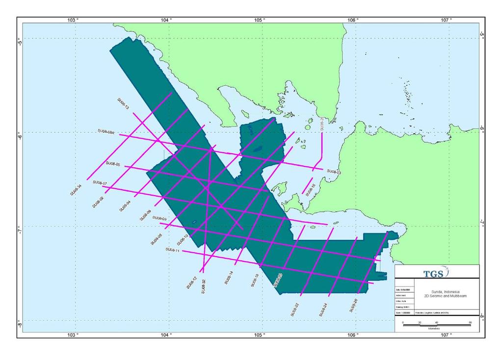
Indonesia Frontier Basin SUNDA (SU-08) NON-EXCLUSIVE 2-D SURVEY 3084km
|
|
|
- Damon Sims
- 6 years ago
- Views:
Transcription
1 Indonesia Frontier Basin SUNDA (SU-08) NON-EXCLUSIVE 2-D SURVEY 3084km SEISMIC ACQUISITION PARAMETERS Acquisition Date: January - March 2008 Vessel: M/V Osprey Explorer Shooting Orientation: Strike-Dip Recording Instrument: Syntrak Seal 24 bit Streamer Type: Sercel Seal Streamer Positioning: C-Nav DGPS Airgun Source: 3820 cu. In. Bolt LL-X 1900, LL-X 1500 Gun Depth: 6m Shotpoint Interval: 37.5m Group Interval: 12.5m Recording Channels: 564 Streamer Depth: 7m +/- 1m Streamer Length: 7050 metres Record Length: 12sec Sample Interval: 2ms Nominal Fold: 94 Recording format and media type: SEG-D 3590 Cartridges
2 SEISMIC PROCESSING SEQUENCE SEISMIC AVAILABLE DELIVERABLES Filtered 2D Migration Angle Stacks Final velocities Final Acquisition &Processing Reports Navigation Data Optional Data Available: o Radon Gathers o PSTM Gathers o Field Data
3 ACEH NON-EXCLUSIVE SEA SEEP SURVEY Multibeam 26,619sq km Gravity/Magnetics 7,792 km Sea Floor Cores 76 Total Geochem samples 198 Heat Flow Probes 3 MISOOL MULTIBEAM ACQUISITION PARAMETERS Acquisition Date: August - September 2007 Vessel: M/V L Espoir Shooting Orientation: 3D coverage Survey Positioning Control C-Nav Starfire DGPS Multibeam Echo Sounder: Kongsberg Simrad EM120 No. of beams: 191 equidistant spacing Cross Track Beam Spacing: +/- 23m In track Beam spacing: +/- 50m Backscatter Mosaicing Software: Konsberg Simrad Poseidon Single Beam Echo Sounder: EA400 Knudsen Sub Bottom Profile Source: Massa 137D16 element (4x4) transducer Power Supply: Knudsen Receiver: Knudsen Mode: Chirp Maximum Penetration: 80m Average Penetration: 20m Gravity Acquisition Instrumentation: ZLS Ultrasys Marine System Sensor: Dynamic Gravity Sensor D003 Settings: High Resolution 1 sec interval Magnetometer: Geometrics 882 Self oscillating split beam Caesium Vapour Magnetometer Cable: 200m streamed at 7m depth BATHYMETRY AND BACKSCATTER PROCESSING SEQUENCE Bathymetry Line by line processing Position Processing Depth Processing tidal and calibration corrections Data Cleaning random noise and artefacts Terrain Modeling 25m bin size Gridding and export to ESRI format Backscatter Line by line processing Position Processing Depth Processing tidal and calibration corrections Data Cleaning random noise and artefacts Load into Poseidon Backscatter data set to -5dB to -60dB dynamic range 5m binning Gridding and export to ESRI format KNUDSEN CHIRP PROCESSING SEQUENCE Recorded in SEGY format and Knudsen.keb format Assumed velocity 1700m/sec Output to SEGY Filter and Ping Settings optimized Output to Knudsen.keb
4 MULTIBEAM, GRAV/MAG, and SUB BOTTOM PROFILE AVAILABLE DELIVERABLES Multibeam bathymetry grid (25x25 meter resolution) Multibeam backscatter grid (5x5 meter resolution; in db) Gravity data grids Free Air (integrated with satellite gravity Free Air (survey only) Full 3D Bouguer Gravity Magnetic data grids Total Magnetic Field Reduced to Pole Magnetic Anomaly Gravity and Magnetic processing report Subbottom profile data knudsen files Subbottom profile data Kingdom project ships navigation GIS maps showing: o Bathymetry (Grids and contours) o Backscatter (Grids) o Gravity (Grids and Contours) o Magnetics (Grids and Contours)
5 SEA FLOOR CORING AND HEAT FLOW PROBE ACQUISITION PARAMETERS Acquisition Date: March 2008 Vessel: RV Geoexplorer Shooting Orientation: Targeted piston cores and Heat Flow Probes Coring Mechanism: Weighted Piston Core with trigger assembly Core Length: 6m Core Assembly Weight: 900kg Core liner: Butyrate Heat Flow Probe: Lister Type Probe Sensors: 11 x glass bead thermistors Heat Flow Probe Penetration: 5.5m SEA FLOOR CORE AND HEAT PROBE PROCESSING SEQUENCE SEA FLOOR CORES Cores cut into 20cm sections Test for Total Scanning Fluorescence Test for C15+ Test for Head Space Gas Exude any materials for Biomarker testing Seal and Store samples at -15 to -20 deg C Transport to Lab Geochemical Laboratory Analysis HEAT PROBES Data selection based on penetration time and heat pulse Data Reduction using HFRED Construction of Bullard Plots Interpretation of Results SEA FLOOR CORING AND HEAT FLOW PROBE AVAILABLE DELIVERABLES Coring and Heat Flow acquisition Report for each Basin Standard geochemistry of normally 3 samples per core; o Head space gas analysis o Total scanning fluorescence o GC C15+ Advanced geochemical analysis (only on samples with significant hydrocarbons present) o Aliphatic and Aromatic Biological Markers o Stable Carbon Isotopes on methane o Stable Carbon Isotopes, C2, C3 and C4 components Geochemistry and Heat Flow report for each basin GIS maps showing o Core and Heat Flow locations o core recovery o geochemistry results o heat flow results
6
Offshore Operations and Project Execution Geophysical Site Surveys
 Offshore Operations and Project Execution Geophysical Site Surveys Chris Almond Senior Geophysicist Fugro Survey Limited 22/04/2015 Presentation Summary: Office-based Personnel Project Awarded Pre Offshore
7.0 Project Reports 7.1 Geophysical Mapping of Submarine Environments
 7.0 Project Reports 7.1 Geophysical Mapping of Submarine Environments Suzanne Carbotte, Robin Bell, Roger Flood 7.1.1 METHODS In April 2000 we deployed the R/V Onrust, operated by MSRC at SUNY Stony Brook,
Outline of presentation
 - lessons learnt from precedent cases of establishing the s Outline of presentation Extending Ireland s continental shelf jurisdiction to the outer s in the Porcupine Abyssal Plain: progress, issues and
Smart Survey Approach: Multibeam Echosounder and Integrated Water Column Data as an Added Value for Seep Hunting
 Smart Survey Approach: Multibeam Echosounder and Integrated Water Column Data as an Added Value for Seep Hunting HYDRO 2016 8 November 2016 Marco Filippone Introduction, Multibeam Sonars & water column
Marine Geophysical Methods: What Can and Cannot Be Done to Iden8fy Hazards to Dredging & Marine Construc8on
 Marine Geophysical Methods: What Can and Cannot Be Done to Iden8fy Hazards to Dredging & Marine Construc8on Marine Geophysics Sham or Savior? Seen alternatively as the silver bullet or snake oil, marine
CHAPTER 6 RESULTS FIGURE 8.- DATA WORK FLOW FOR BACKSCATTER PROCESSING IN HYPACK
 CHAPTER 6 RESULTS 6.1. Backscatter Workflow Comparison Currently, INOCAR owns and operates RESON and Kongsberg multibeam systems for nearshore surveys. The RESON system is integrated with HYPACK Hysweep
IODP Science Evaluation Panel: Guidelines and Rationale for Site Characterization Data (Revised: August 2013)
") Site Characterization Data Guidelines IODP Science Evaluation Panel: Guidelines and Rationale for Site Characterization Data (Revised: August 2013) This document outlines the method and rationale for data
Site Characterization Data Guidelines IODP Science Evaluation Panel: Guidelines and Rationale for Site Characterization Data (Revised: August 2013) This document outlines the method and rationale for data
3. UNDERWAY GEOPHYSICS 1
 Sawyer, D.S., Whitmarsh, R.B., Klaus, A., et al., 1994 Proceedings of the Ocean Drilling Program, Initial Reports, Vol. 149 3. UNDERWAY GEOPHYSICS 1 Shipboard Scientific Party 2 EQUIPMENT AND METHODS Navigation
Gigante: the first step to getting a comprehensive view of the Gulf of Mexico. Chris Corona Alex Birch-Hawkins September 17, 2015
 Gigante: the first step to getting a comprehensive view of the Gulf of Mexico Chris Corona Alex Birch-Hawkins September 17, 2015 2015 TGS-NOPEC Geophysical Company ASA. All rights reserved. 2 Discussion
GEOL- 270: Issues in Oceanography Developed by Jessica Kleiss, Lewis & Clark College
 GEOL- 270: Issues in Oceanography Developed by Jessica Kleiss, Lewis & Clark College Lab 02: Ocean floor bathymetry. Material for students to bring: A calculator A ruler Pens and pencils Objectives: Interpret
Topic: Bathymetric Survey Techniques. (a) Single-beam echo-sounders (SBES) (b) Multi-beam echo-sounders (MBES)
 Single-beam echo-sounders (SBES) (b) Multi-beam echo-sounders (MBES)") Topic: Bathymetric Survey Techniques (a) Single-beam echo-sounders (SBES) (b) Multi-beam echo-sounders (MBES) Bathymetry is the measurement of water depths - bathymetry is the underwater equivalent of
Topic: Bathymetric Survey Techniques (a) Single-beam echo-sounders (SBES) (b) Multi-beam echo-sounders (MBES) Bathymetry is the measurement of water depths - bathymetry is the underwater equivalent of
Changes in Geomorphology and Backscatter Patterns in Mount Misery Shoal, Long Island Sound as Revealed through Multiple Multibeam Surveys
 Changes in Geomorphology and Backscatter Patterns in Mount Misery Shoal, Long Island Sound as Revealed through Multiple Multibeam Surveys Laurie A. Zaleski Laurie.Zaleski@msrc.sunysb.edu, Roger D. Flood
FLUVIA NAUTIC DATASET (16 March 2007) Description of the sensor logs
 Description of the sensor logs") FLUVIA NAUTIC DATASET (16 March 2007) Description of the sensor logs David Ribas, PhD Student. Underwater Robotics Lab, Computer Vision and Robotics Group, University of Girona Doppler Velocity Log (Argonaut
FLUVIA NAUTIC DATASET (16 March 2007) Description of the sensor logs David Ribas, PhD Student. Underwater Robotics Lab, Computer Vision and Robotics Group, University of Girona Doppler Velocity Log (Argonaut
Monitoring The Sand Extraction On The Belgian Continental Shelf
 Monitoring The Sand Extraction On The Belgian Continental Shelf Methodology, Results And Expectations K. Degrendele and M. Roche Within the framework of a sustainable exploitation of the mineral resources
Automated Seabed Mapping and Data Delivery in the Cloud
 Automated Seabed Mapping and Data Delivery in the Cloud London, 2nd November 2017 11/20/2017 1 2 WE CALL IT SEABED INTELLIGENCE Ocean Infinity are explorers. We go to unmapped locations to survey the seabed
Changes in bottom morphology of Long Island Sound near Mount Misery Shoal as observed through Repeated Multibeam Surveys
 Changes in bottom morphology of Long Island Sound near Mount Misery Shoal as observed through Repeated Multibeam Surveys Laurie A. Zaleski Laurie.Zaleski@msrc.sunysb.edu Roger D. Flood rflood@notes.cc.sunysb.edu
Short summary of Project 1 activity during research cruise with RV Poseidon (P408-2b)
") Short summary of Project 1 activity during research cruise with RV Poseidon (P408-2b) Chief scientist: Dr. Mark Schmidt Shipboard scientific party: Dr. Peter Linke, Dr. Daniel McGinnis, Dr. Alaa Al-Barakati,
Short summary of Project 1 activity during research cruise with RV Poseidon (P408-2b) Chief scientist: Dr. Mark Schmidt Shipboard scientific party: Dr. Peter Linke, Dr. Daniel McGinnis, Dr. Alaa Al-Barakati,
SonTek HydroSurveyor M9 now powered by HYPACK! CASE STUDY: USGS HYDROSURVEYOR SURVEY OF FENA VALLEY RESERVOIR, GUAM
 SonTek HydroSurveyor M9 now powered by HYPACK! CASE STUDY: USGS HYDROSURVEYOR SURVEY OF FENA VALLEY RESERVOIR, GUAM Presenters Harold Orlinsky General Manager HYPACK Isaac Jones Product manager, SonTek
P-Cable UHR3D Seismic What is it, and when is it better? Presented by: Brian Brookshire, NCS SubSea By Invitation of: SUT Houston's Offshore Site
 P-Cable UHR3D Seismic What is it, and when is it better? Presented by: Brian Brookshire, NCS SubSea By Invitation of: SUT Houston's Offshore Site Investigation and Geotechnics Committee Contents What is
3. UNDERWAY GEOPHYSICS 1
 Mayer, L., Pisias, N., Janecek, T., et al., 1992 Proceedings of the Ocean Drilling Program, Initial Reports, Vol. 138 3. UNDERWAY GEOPHYSICS 1 Stephen F. Bloomer 2 and Shipboard Scientific Party 3 INTRODUCTION
Terje Pedersen Product Manager Software / Hydrography Hydroacoustics Division
 Terje Pedersen Product Manager Software / Hydrography Hydroacoustics Division WORLD CLASS through people, technology and dedication WORLD CLASS through people, technology and dedication 1 2 HYDROFEST 2005
An Introduction to Geophysical Exploration
 An Introduction to Geophysical Exploration Philip Kearey Department of Earth Sciences University of Bristol Michael Brooks Ty Newydd, City Near Cowbridge Vale of Glamorgan Ian Hill Department of Geology
Appendix H High Resolution Marine Seismic Reflection Surveys
 Appendix H High Resolution Marine Seismic Reflection Surveys Shoreline Fault Zone Report, Appendix H Seis. Reflection Page H-1 of 8 Introduction Single-channel seismic-reflection data were acquired in
CRUISE REPORT MARINE GEOLOGICAL CRUISE TO ULLSFJORDEN, LYNGEN, OFOTEN AND TYSFJORDEN, NORTH NORWAY. RV Jan Mayen by Jan Sverre Laberg
 CRUISE REPORT MARINE GEOLOGICAL CRUISE TO ULLSFJORDEN, LYNGEN, OFOTEN AND TYSFJORDEN, NORTH NORWAY RV Jan Mayen 6. - 12.2 2006 by Jan Sverre Laberg DEPARTMENT OF GEOLOGY UNIVERSITY OF TROMSØ N-9037 TROMSØ,
Parametric Sub Bottom Profiler measurements of the subaquatic portion of the debris fan of Gschliefgraben in Lake Traunsee, Austria
 Parametric Sub Bottom Profiler measurements of the subaquatic portion of the debris fan of Gschliefgraben in Lake Traunsee, Austria Brian Kreis & Sebastian Riegler (students) Erwin Heine supported by INNOMAR
Elements of 3D Seismology Second Edition
 Elements of 3D Seismology Second Edition Copyright c 1993-2003 All rights reserved Christopher L. Liner Department of Geosciences University of Tulsa August 14, 2003 For David and Samantha And to the memory
INTRODUCTION TO APPLIED GEOPHYSICS
 INTRODUCTION TO APPLIED GEOPHYSICS EXPLORING THE SHALL0W SUBSURFACE H. Robert Burger Anne F. Sheehan Craig H.Jones VERSITY OF COLORADO VERSITY OF COLORADO W. W. NORTON & COMPANY NEW YORK LONDON Contents
We E Estimation of Induction Noise in a Towed EM Streamer
 We E108 07 Estimation of Induction Noise in a Towed EM Streamer A.L. Tcheheumeni Djanni* (The University of Edinburgh), A. Ziolkowski (The University of Edinburgh) & D. Wright (The University of Edinburgh)
Automatic compensation for seafloor slope and depth in post-processing recovery of seismic amplitudes
 O Acoustics 2017 IEEE/OES IN UNDERWATER GEOSCIENCES SYMPOSIUM CPRM, Urca, Rio de Janeiro, Brazil July 25-27, 2017 Automatic compensation for seafloor slope and depth in post-processing recovery of seismic
Marine Heat Flow Measurements Information Brochure
 Marine Heat Flow Measurements Information Brochure 5 1 2 3 4 5 5 6 7 8 5 9 10 11 12 13 14 5 15 16 17 18 19 20 21 5 22 0 200 400 600 800 1000 1200 1400 1600 Time (s) What is the use of heat flow measurements?
Gas Hydrate R&D from 1996 to Regional Survey. activities at KIGAM. Byong-Jae Ryu
 Gas Hydrate R&D from 1996 to 1999 Regional Survey Gas Hydrate R&D activities at Byong-Jae Ryu Korea Institute of Geoscience & Mineral Resources was established in 1918 (Office of Geological Survey) Organization
A lithological map created from multibeam backscatter data in challenging circumstances: the Lower Sea Scheldt estuary
 A lithological map created from multibeam backscatter data in challenging circumstances: the Lower Sea Scheldt estuary Mieke Mathys*, Marc Sas*, Frederik Roose** HYDRO12, Rotterdam, 15/11/2012 *International
FloatSeis Technologies for Ultra-Deep Imaging Seismic Surveys
 FloatSeis Technologies for Ultra-Deep Imaging Seismic Surveys 25 th January, 2018 Aleksandr Nikitin a.nikitin@gwl-geo.com Geology Without Limits Overview 2011-2016 GWL Acquired over 43000 km 2D seismic
P2061 Relinquishment Report
 Document last updated 23-07-2015 12:28 CEST 1 Licence Information 1 2 Licence Synopsis 2 3 Work Program 4 4 Database 8 4.1 Seismic 8 4.2 Gravity and Magnetics 10 5 Prospectivity Update 12 6 Resource and
BAUER MeBo Sea Bed Drill Rig
 BAUER MeBo Sea Bed Drill Rig Spotlights BAUER Maritime Experiences 1993 Diamond deposit exploration with a BC cutter in water depth of 160 m (South Africa) Atlantic Ocean 2005 Drilling inside of a monopile
Acoustic seafloor mapping systems. September 14, 2010
 Acoustic seafloor mapping systems September 14, 010 1 Delft Vermelding Institute onderdeel of Earth organisatie Observation and Space Systems Acoustic seafloor mapping techniques Single-beam echosounder
Appendix A. Background Information Document
 Appendix A Background Information Document BACKGROUND INFORMATION DOCUMENT Proposed oil and gas exploration activities in the Deepwater Durban Exploration Area, offshore of the East Coast of South Africa
Charleston to Woods Hole R/V Armstrong Transit: Atlantic Margin Upper Slope Fluid Flow Features, Seafloor and Water Column Surveys
 Charleston to Woods Hole R/V Armstrong Transit: Atlantic Margin Upper Slope Fluid Flow Features, Seafloor and Water Column Surveys Contacts: Carolyn Ruppel (US Geological Survey, cruppel@usgs.gov, 508-457-2339)
Short summary of Project 1 activity during research cruise with RV Poseidon (P408-2a)
") Short summary of Project 1 activity during research cruise with RV Poseidon (P408-2a) Chief scientist: Dr. Mark Schmidt Shipboard scientific party: Dr. Peter Linke, Dr. Daniel McGinnis, Dr. Alaa Al-Barakati,
Short summary of Project 1 activity during research cruise with RV Poseidon (P408-2a) Chief scientist: Dr. Mark Schmidt Shipboard scientific party: Dr. Peter Linke, Dr. Daniel McGinnis, Dr. Alaa Al-Barakati,
MULTI-SENSOR CORE LOGGING (MSCL) AND X-RAY RADIOGRAPHY CORE LOGGING SERVICES
 AND X-RAY RADIOGRAPHY CORE LOGGING SERVICES") MULTI-SENSOR CORE LOGGING (MSCL) AND X-RAY RADIOGRAPHY CORE LOGGING SERVICES IF CORE S WORTH TAKING, IT S WORTH LOGGING MSCL APPLICATIONS Any core material collected for a science or engineering objective
MULTI-SENSOR CORE LOGGING (MSCL) AND X-RAY RADIOGRAPHY CORE LOGGING SERVICES IF CORE S WORTH TAKING, IT S WORTH LOGGING MSCL APPLICATIONS Any core material collected for a science or engineering objective
Gravity in the Ryukyu Arc*
 Journal of the Geodetic Society of Japan Vol. 22, No. 1, (1976), pp. 23-39 Gravity in the Ryukyu Arc* Jiro SEGAWA Ocean Research Institute, University of Tokyo (Received March 31, 1976; Revised May 22,
Analysis of Physical Oceanographic Data from Bonne Bay, September 2002 September 2004
 Physics and Physical Oceanography Data Report -1 Analysis of Physical Oceanographic Data from Bonne Bay, September September Clark Richards and Brad deyoung Nov. 9 Department of Physics and Physical Oceanography
Last Time. GY 305: Geophysics. Seismology (Marine Surveys) Seismology. Seismology. Other Seismic Techniques UNIVERSITY OF SOUTH ALABAMA
 Seismology. Seismology. Other Seismic Techniques UNIVERSITY OF SOUTH ALABAMA") UNIVERSITY OF SOUTH ALABAMA Last Time GY 305: Geophysics Lecture 12: Introduction to (resolution versus penetration) Techniques (marine versus terrestrial) (Marine Surveys) http://www.glossary.oilfield.slb.com/displayimage.cfm?id=236
UNIVERSITY OF SOUTH ALABAMA Last Time GY 305: Geophysics Lecture 12: Introduction to (resolution versus penetration) Techniques (marine versus terrestrial) (Marine Surveys) http://www.glossary.oilfield.slb.com/displayimage.cfm?id=236
Autoresonant Ion Trap Mass Spectrometer The RGA Alternative
 Autoresonant Ion Trap Mass Spectrometer The GA Alternative 1 What is a Mass Spectrometer? Ionizer Mass Spectrometer Mass Separator Magnetic Sector, Quadrupole or Ion Trap Detector Partial Pressure Measurement
SONGS Seismic Research Projects
 SONGS Seismic Research Projects Energy Division Independent Peer Review Group September 21, 2012 Agenda Background Overview Project Support Permits, Approvals, and Reviews Schedule Use of Advanced Technologies
Shape of the Earth. Data Output by the Receiver
 It is quite common for confusion to arise about the process used during a hydrographic survey when GPS-derived water surface elevation is incorporated into the data as an RTK Tide correction. This article
SITE SURVEY FOR SITE 410, AN EXAMPLE OF THE USE OF LONG-RANGE SIDE-SCAN SONAR (GLORIA)
") 10. SITE SURVEY FOR SITE 410, AN EXAMPLE OF THE USE OF LONG-RANGE SIDE-SCAN SONAR (GLORIA) R. C. Searle and A. S. Laughton, Institute of Oceanographic Sciences, Wormley, GU8 5UB, UK and B. D. Loncarevic,
10. SITE SURVEY FOR SITE 410, AN EXAMPLE OF THE USE OF LONG-RANGE SIDE-SCAN SONAR (GLORIA) R. C. Searle and A. S. Laughton, Institute of Oceanographic Sciences, Wormley, GU8 5UB, UK and B. D. Loncarevic,
3.2 Geophysical Habitat Mapping
 APPENDIX 3 GEOPHYSICS Prepared for: Namibian Marine Phosphate (Pty) Ltd. Prepared by: Jeremy Midgley September 2014 Mr Jeremy Midgley Pr.Sci.Nat J. Midgley & Associates PO Box 110 Constantia 7806 South
The Arctic - A New Frontier The geological, environmental and engineering challenges for submarine telecommunication cables
 The Arctic - A New Frontier The geological, environmental and engineering challenges for submarine telecommunication cables Ryan Wopschall 5 September 2013 Oceanology International China, Shanghai Fugro
Results of the RV Simon Stevin EM2040 Sea Acceptance Test and comparison with EM3002D data from the HS Ter Streep and RV Belgica.
 Results of the RV Simon Stevin EM2040 Sea Acceptance Test and comparison with EM3002D data from the HS Ter Streep and RV Belgica. Cattrijsse Andre, Degrendele Koen, De Mol Lies, Naudts Lieven, Roche Marc,
REPORT ON GEOCHEMICAL ANALYSES OF PISTON CORED SAMPLES, OFFSHORE NOVA SCOTIA. M. Fowler and J. Webb, APT Canada
 REPORT ON GEOCHEMICAL ANALYSES OF PISTON CORED SAMPLES, OFFSHORE NOVA SCOTIA M. Fowler and J. Webb, APT Canada Sampling sites for piston-coring were carefully selected based on satellite and seismic data.
Tu N Fault Shadow Removal over Timor Trough Using Broadband Seismic, FWI and Fault Constrained Tomography
 Tu N118 05 Fault Shadow Removal over Timor Trough Using Broadband Seismic, FWI and Fault Constrained Tomography Y. Guo* (CGG), M. Fujimoto (INPEX), S. Wu (CGG) & Y. Sasaki (INPEX) SUMMARY Thrust-complex
Diablo Canyon SSHAC Level 3 Study
 1 Diablo Canyon SSHAC Level 3 Study Workshop 1 Summary of SSC Hazard Significant Issues and Data Needed William Lettis November 29 to December 1, 2011 PG&E DCPP SSHAC Study 2 Hosgri Hosgri Location Hosgri
Lower 8.3 Miles of the Lower Passaic River Operable Unit 2 Presentation to The Passaic River Community Advisory Group. September 14, 2017
 Lower 8.3 Miles of the Lower Passaic River Operable Unit 2 Presentation to The Passaic River Community Advisory Group September 14, 2017 Agenda Pre-Design Investigation (PDI) Status Geophysical, Bathymetric,
surr1ch H Y D R 0 G R A P H I C S Capability Statelllent
 H Y D R 0 G R A P H I C S Capability Statelllent 2015 Company Profile Surrich Hydrographics provides Level 1 Certified Hydrographic Services and Geophysical Services for activities including navigational
Tu A4 01 Shooting Over the Streamer Spread; a Novel Approach in Seismic Marine Acquisition and Imaging
 Tu A4 01 Shooting Over the Streamer Spread; a Novel Approach in Seismic Marine Acquisition and Imaging V. Vinje* (CGG), J.E. Lie (Lundin Norway), V. Danielsen (Lundin Norway), P.E. Dhelie (Lundin Norway),
Introduction to Formation Evaluation Abiodun Matthew Amao
 Introduction to Formation Evaluation By Abiodun Matthew Amao Monday, September 09, 2013 Well Logging PGE 492 1 Lecture Outline What is formation evaluation? Why do we evaluate formation? What do we evaluate?
FINMARINET: Inventories and Planning for the Marine Natura 2000 Network in Finland. A.2 Geological inventories of the seafloor Final Report
 LIFE07 NAT/FIN/000151 FINMARINET: Inventories and Planning for the Marine Natura 2000 Network in Finland A.2 Geological inventories of the seafloor Final Report Geological Survey of Finland, GTK 1. Introduction
Table of Contents. Introduction 4. Chapter 1 Research and the Deep Oceans 6. Chapter 2 Physical Characteristics of the Ocean 10
 Table of Contents Introduction 4 Chapter 1 Research and the Deep Oceans 6 Chapter 2 Physical Characteristics of the Ocean 10 Chapter 3 Composition of the Oceans Waters 16 Chapter 4 Tides, Waves, and Currents
STATISTICAL ANALYSIS FOR AUTOMATED SEEP EXTRACTION IN GIS
 STATISTICAL ANALYSIS FOR AUTOMATED SEEP EXTRACTION IN GIS Presented by Pamela Kanu, GISP ESRI USER CONFERENCE JULY 2017 SEEPS Seeps are natural gas and crude oil that enter the ocean through cracks and
Cold Water Coral WHY?
 The Cold Water Coral Research by bathymetry, acoustic geophysical and methane data, Santa Maria di Leuca, Northern Ionian Sea Apulian continental slop. Speaker: Kuan-Ting Lin March 15 th 2012 WHY? Where
Iceland. Licensing of the Dreki Area. Thorarinn Arnarson
 Iceland Licensing of the Dreki Area Thorarinn Arnarson Stavanger 6 June 2011 Presentation topics Licensing Environmental conditions Geological and geophysical data Second Icelandic licensing round northern
Digital Elevation Model (DEM) of Sable Island Bank and adjacent areas
 of Sable Island Bank and adjacent areas") GEOLOGICAL SURVEY OF CANADA OPEN FILE 5348 Digital Elevation Model (DEM) of Sable Island Bank and adjacent areas K.J. Webb and E.L. King 2014 GEOLOGICAL SURVEY OF CANADA OPEN FILE 5348 Digital Elevation
GEOLOGICAL SURVEY OF CANADA OPEN FILE 5348 Digital Elevation Model (DEM) of Sable Island Bank and adjacent areas K.J. Webb and E.L. King 2014 GEOLOGICAL SURVEY OF CANADA OPEN FILE 5348 Digital Elevation
Themes for Geomatics Conference. Geodesy Themes
 Themes for Geomatics Conference Geodesy Themes Geodynamics o Modeling the Deformation of the Earth s Crust o Recent Advances in Geometric Approaches to Deformation Analysis o Monitoring Systems (Sensors
Modeling and interpretation of CSEM data from Bressay, Bentley and Kraken area of East Shetland Platform, North Sea
 from Bressay, Bentley and Kraken area of East Shetland Platform, North Sea Anwar Bhuiyan*, Rune Sakariassen, Øystein Hallanger and Allan McKay, PGS Summary The heavy oil reservoirs of the Bentley, Bressay
Cruise Report YK10-06
 Cruise Report YK10-06 (R/V Yokosuka) Site Surveys for drilling projects of IODP at the Kumano-nada and the northern Izu-Bonin arc June 13 20, 2010 Center for Deep Earth Exploration (CDEX) Japan Agency
Chapter 13: Exploration Techniques
 PTRT 1370 - Petroleum Geology Chapter 13: Exploration Techniques - Mapping - Geophysical Techniques - Seismic Exploration Mapping - Topographic Maps - Absolute Positioning - Geologic Maps - Base Maps -
H.A.R.S. PRA #1 (Historic Area Remediation Site)
") H.A.R.S. PRA #1 (Historic Area Remediation Site) 2009 Multibeam Bathymetry TABLE OF CONTENTS Page LIST OF TABLES 2 LIST OF FIGURES 3 1.0 INTRODUCTION 4 2.0 OBJECTIVE 4 3.0 PROCEDURE 4 3.1 DATA ACQUISITION
H.A.R.S. PRA #1 (Historic Area Remediation Site) 2009 Multibeam Bathymetry TABLE OF CONTENTS Page LIST OF TABLES 2 LIST OF FIGURES 3 1.0 INTRODUCTION 4 2.0 OBJECTIVE 4 3.0 PROCEDURE 4 3.1 DATA ACQUISITION
Recent developments in multi-beam echo-sounder processing at the Delft
 Recent developments in multi-beam echo-sounder processing at the Delft University of Technology Prof. Dr. Dick G. Simons Acoustic Remote Sensing Group, Faculty of Aerospace Engineering, Delft University
Data and Information Management. UK All Energy 22 nd May Presented by Leo James
 Data and Information Management UK All Energy 22 nd May 2013 Presented by Leo James Strategic Development Plans Observations at the outset Data and information management and dissemination: company or
Sediment classification from multibeam backscatter images using simple histogram analysis
 Sediment classification from multibeam backscatter images using simple histogram analysis Rozaimi Che Hasan 1,2, Mohd Razali Mahmud 3 and Shahrin Amizul Shamsudin 1 1 UTM Razak School of Engineering and
JMRS11 Jan Mayen Ridge Sampling Survey 2011
 JMRS11 Jan Mayen Ridge Sampling Survey 2011 JMRS11 Report Presentation VBPR/TGS, February 2012 Confidentiality Screen dumps and the underlying data in this document are confidential and proprietary to
NOAA/University of New Hampshire Joint Hydrographic Center & Center for Coastal and Ocean Mapping. MAPPS Summer Conference July 23, 2013
 NOAA/University of New Hampshire Joint Hydrographic Center & Center for Coastal and Ocean Mapping MAPPS Summer Conference July 23, 2013 07/23/2013 2 07/23/2013 3 Center Goals To be a world leader in the
Geochemistry, Geophysics, Geosystems. Supporting Information for
 Geochemistry, Geophysics, Geosystems Supporting Information for Segment-scale variations in seafloor volcanic and tectonic processes from multibeam sonar imaging, Mid-Atlantic Ridge Rainbow region (35º45-36º35
TIMEZERO PROFESIONAL V3.2
 TIMEZERO PROFESIONAL V3.2 Main New Features TIMEZERO PROFESIONAL V3.2-1 - WASSP G3 (S3 and F3) Compatibility:... - 3 - Misc. Features:... - 7 - TIMEZERO PROFESIONAL V3.2-2 - TIMEZERO Professional (with
Reprocessing strategy for shallower prospects from the available 3D data set Case history of Cambay Basin
 P-378 Reprocessing strategy for shallower prospects from the available 3D data set Case history of Cambay Basin M.Singh*, Vikash Chandra, USD Pandey Summary The occurrence of non commercial hydrocarbons
LAMONT-DOHERTY GEOLOGICAL OBERVATORY DATA REDUCTION CRUISE SUMMARY
 LAMONT-DOHERTY GEOLOGICAL OBERVATORY DATA REDUCTION CRUISE SUMMARY " A GLORIA, HYDROSWEEP, geophysical investigation of the Juan Fernandez microplate" PAPEETE, TAHITI - VALPARAISO, CHILE 06/16/91 (JD 167)
12/11/2013& egm502 seafloor mapping
 egm502 seafloor mapping lecture 13 multi-beam echo-sounders The majority of the current charts of the ocean floors have been produced from single beam echo-sounder data. Even though these data have been
Earth in 2-D, 3-D & 4-D
 Earth in 2-D, 3-D & 4-D We will consider the scientific tools and techniques used to map surface features, reconstruct the layered structure of Earth, and interpret Earth history, including the origin
Multi-channel seismic reflection experiments in Izu-Ogasawara arc cruises-
 JAMSTEC Report of Research and Development, Volume 4, November 2006, 1 12 Multi-channel seismic reflection experiments in Izu-Ogasawara arc -2005 cruises- K. Takizawa 1, T. Tsuru 2, Y. Kaiho 1, M. Yamashita
A Review Archaeological Geophysical Remote Surveying for the Seafloor
 A Review Archaeological Geophysical Remote Surveying for the Seafloor C. R. Bates, Sedimentary Systems Research Group, University of St Andrews Over the past 20 years the offshore survey community has
NEW SEAFLOOR INSTALLATIONS REQUIRE ULTRA-HIGH RESOLUTION SURVEYS
 NEW SEAFLOOR INSTALLATIONS REQUIRE ULTRA-HIGH RESOLUTION SURVEYS Donald Hussong (Fugro Seafloor Surveys, Inc.) dhussong@fugro.com Fugro Seafloor Surveys, Inc., 1100 Dexter Avenue North (Suite 100), Seattle,
Estimating vertical and horizontal resistivity of the overburden and the reservoir for the Alvheim Boa field. Folke Engelmark* and Johan Mattsson, PGS
 Estimating vertical and horizontal resistivity of the overburden and the reservoir for the Alvheim Boa field. Folke Engelmark* and Johan Mattsson, PGS Summary Towed streamer EM data was acquired in October
Downloaded 09/29/16 to Redistribution subject to SEG license or copyright; see Terms of Use at
 Richard Wright*, James Carter, Ian Atkinson, Erin Gillis, Deric Cameron, and Leona Stead, Nalcor Energy Tom Neugebauer, TGS Jerry Witney, PGS Daniel Hughes and Michael Hall, Airbus Defence and Space Summary
Map shows 3 main features of ocean floor
 Map shows 3 main features of ocean floor 2017 Pearson Education, Inc. Chapter 3 Marine Provinces 2017 Pearson Education, Inc. 1 Chapter 3 Overview The study of bathymetry determines ocean depths and ocean
Underwater Acoustics OCEN 201
 Underwater Acoustics OCEN 01 TYPES OF UNDERWATER ACOUSTIC SYSTEMS Active Sonar Systems Active echo ranging sonar is used by ships to locate submarine targets. Depth sounders send short pulses downward
Ultrasonic Measuring System for Deposition of Sediments in Reservoirs
 MECAHITECH 11, vol. 3, year: 011 Ultrasonic Measuring System for Deposition of Sediments in Reservoirs M. Mărgăritescu* 1, A. Moldovanu * 1, P. Boeriu *, A.M.E. Rolea* 1 * 1 National Institute of Research
ERTH3021: Exploration and Mining Geophysics
 Course Profile ERTH3021: Exploration and Mining Geophysics Semester 2, 2014 Course Outline: This course builds on the general introduction provided by ERTH2020, and examines common applied-geophysical
The Self-Compensating Magnetometer (SCM) System Test Results from a Remus 600 AUV Survey in Yellowstone Lake. Matthew Kowalczyk Feb 15, 2017
 System Test Results from a Remus 600 AUV Survey in Yellowstone Lake. Matthew Kowalczyk Feb 15, 2017") The Self-Compensating Magnetometer (SCM) System Test Results from a Remus 600 AUV Survey in Yellowstone Lake Matthew Kowalczyk Feb 15, 2017 Company History OFG was formed in 2007 to develop and deploy
The Self-Compensating Magnetometer (SCM) System Test Results from a Remus 600 AUV Survey in Yellowstone Lake Matthew Kowalczyk Feb 15, 2017 Company History OFG was formed in 2007 to develop and deploy
an accessible interface to marine environmental data Russell Moffitt
 an accessible interface to marine environmental data Russell Moffitt The Atlas Project GOAL: To provide a single point of access to oceanographic and environmental data for use by marine resource researchers,
Geophysical Applications Seismic Reflection Processing
 Seismic reflection data are routinely acquired for multiple purposes such as exploration, mining, or engineering problems. The seismic data are generally acquired in shot-gathers, i.e. the data is sorted
Hydroacoustic survey and bathymetric map creation for Brant Lake, New York
 Hydroacoustic survey and bathymetric map creation for Brant Lake, New York Holly A. Waterfield CLM 1 INTRODUCTION Brant Lake is located in Warren County, New York, within the bounds of the Adirondack Park.
MLLW and the NAD83 Ellipsoid: An Investigation of Local Offsets and Trends Using PPK and Gauge Derived Water Surfaces.
 MLLW and the NAD83 Ellipsoid: An Investigation of Local Offsets and Trends Using PPK and Gauge Derived Water Surfaces. Abstract: Authors Doug Lockhart, Fugro Pelagos, Inc. Andy Orthmann, Fugro Pelagos,
The Bathymetry of the Central Mediterranean Sea in the framework of the EMODnet project a case study of bathymetric data integration and processing.
 The Bathymetry of the Central Mediterranean Sea in the framework of the EMODnet project a case study of bathymetric data integration and processing. Federica Foglini & Marzia Rovere CNR-ISMAR Institute
CSL HERON MAPPING OPERATIONS, MAY 23 RD -JUNE 4 TH BLUE HILL BAY, MAINE, USA OCEAN MAPPING GROUP CRUISE REPORT JAMES MUGGAH AND TRAVIS HAMILTON
 CSL HERON MAPPING OPERATIONS, MAY 23 RD -JUNE 4 TH BLUE HILL BAY, MAINE, USA OCEAN MAPPING GROUP CRUISE REPORT JAMES MUGGAH AND TRAVIS HAMILTON SPRING 2009 / NOVEMBER 2009 OCEAN MAPPING GROUP UNIVERSITY
Challenges of Collecting Data for Article 76 in Ice Covered Waters of the Arctic
 Challenges of Collecting Data for Article 76 in Ice Covered Waters of the Arctic 5 th ABLOS Conference Monaco October 16, 2008 Richard MacDougall - Canada Jacob Verhoef - Canada Wendell Sanford - Canada
Z046 Seismic Characteristics of Gas Migration Structures on the North Atlantic Margin Imaged by High-resolution 3D Seismic
 Z046 Seismic Characteristics of Gas Migration Structures on the North Atlantic Margin Imaged by High-resolution 3D Seismic O.K. Eriksen* (P-Cable 3D Seismic), C. Berndt (IFM-GEOMAR), S. Buenz (University
Using high-density OBC seismic data to optimize the Andrew satellites development
 Using high-density OBC seismic data to optimize the Andrew satellites development Leendert Padmos, 1* Daniel Davies, 1 Merv Davies 1 and John McGarrity 1 Abstract The processed data from conventional towed-streamer
EXPLORING FARADAY S LAW
 EXPLORING FARADAY S LAW OBJECTIVE CONTENTS Experimental studies of the Faraday s law of induction. The Faraday s law of induction is examined by observations of the electromotive force (emf) induced in
Aquadopp HR Profiler: Extended Velocity Range Mode
 Nortek Technical Note No.: TN-028 Title: On the Use of Extended Velocity Range Mode (HR Profiler) Last Edited: January 21, 2010 Authors: Peter J Rusello - NortekUSA, Number of Pages: Aquadopp HR Profiler: