US ARMY CORPS OF ENGINEERS New England District BUILDING STRONG
|
|
|
- Jonas Paul
- 5 years ago
- Views:
Transcription


1 US ARMY CORPS OF ENGINEERS New England District
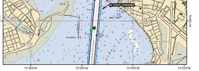
2 STUDIES Sediment Sampling Biological Sampling (benthic community analysis) Hydroacoustic Surveys (side scan sonar, bathymetry) Remotely Operated Vehicle (ROV) Survey

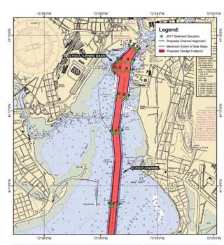
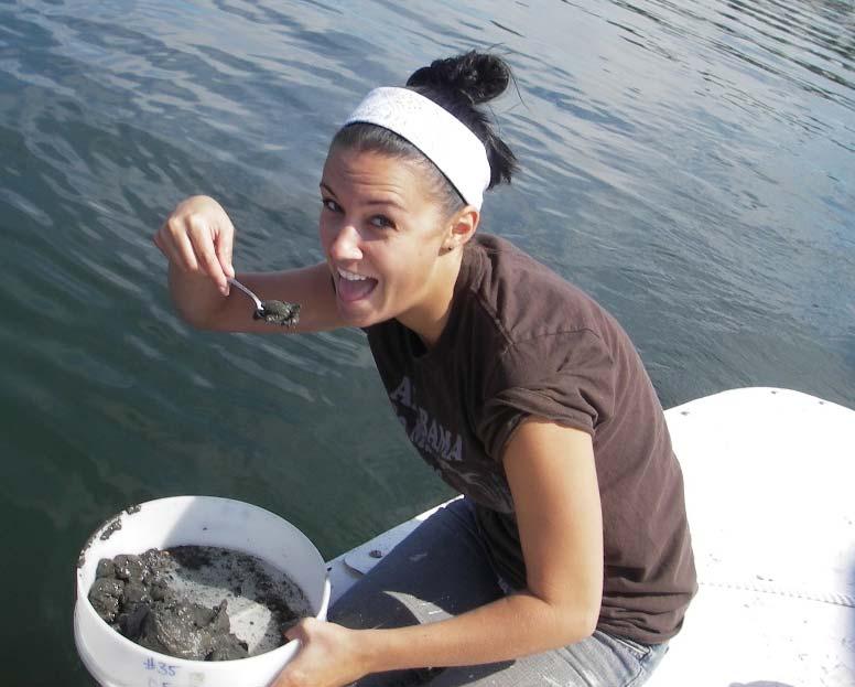
3 SEDIMENT SAMPLING Contractors : AECOM & Ocean Surveys, Inc. Vibracore sampling to deepest project depth alternative (-42 feet MLLW + -2 feet) R/V Candu -OSI


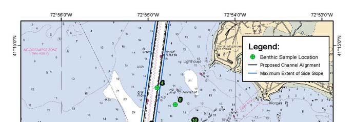
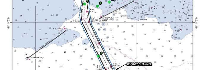
4 Inner Harbor 6 transects 17 Stations BUILDING STRONG


5 Outer Harbor 2 transects 6 stations


6 Core Log from Station A - material type = all fine sand


7 Core Log from Station I - material type = silt and clay


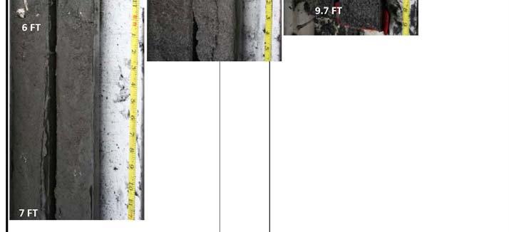
8 Core Log from Station X material type = silt and clay from sediment-water interface to 5.2 / silty sand below
9 Quantities of Dredged Material by Sediment Type Channel Design Depth Rock 7,000 16,000 24,000 33,000 49,000 Sand (fine sand with silt) 121, , , , ,000 Fines 1,984,000 2,591,000 3,355,000 3,885,000 5,245,000 (Silt/Clay) TOTALS 2,112,000 2,777,000 3,624,000 4,269,000 5,769,000
10 Sediment Chemistry Chemical Concentrations of Contaminants of Concern for each core Biological Testing of Each Transect Whole Sediment Testing Suspended Sediment Testing Bioaccumulation Testing Preliminary testing results received in December 2017 and are currently under review. Suitability modelling is ongoing.


11 Sediments at the Potential Shellfish Area 3 locations within area Surficial material = Fines (silt/clay)

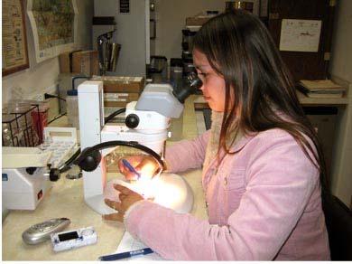
12 Benthic Community Analysis


13 Results of Benthic Community Analysis

14 Reach Group Dominants Inner Mid Group I Group II Spionid polychaetes Oligochaetes Ampeliscid Amphipods Spionid polychaetes Ampeliscid Amphipods Mulinia sp. Tellina sp. Outer Group II Spionid polychaetes Nephtys sp. Shellfish Area Group II Ampeliscid Amphipods Spionid polychaetes Mulinia sp.
 and bathymetry")
15 Hydroacoustic Surveys: EQUIPMENT: R/V Nomad Hemisphere VS330 position and heading system receiving RTK corrections via CTDOT/UCONN CORS network. Teledyne DMS-10 dynamic motion sensor providing heave, pitch, and roll corrections Edgetech 6205 Multi Phase Echo Sounder providing co-registered dual frequency side scan (200/400kHz) and bathymetry (200kHz) with full nadir coverage. Hypack hydrographic software used for navigation, real time data visualization, and recording.
 deployed from the same survey platform used")


16 ROV Survey: EQUIPMENT: Remotely Operated Underwater Vehicle (ROV) deployed from the same survey platform used during hydroacoustic surveys. VideoRay Pro3 GTO used to investigate a subset of targets identified through interpretation of side scan sonar data from the project area. Video feed viewed in real time and recorded to DVR for review and analysis.


17 Survey Plan Side scan sonar survey lines laid out parallel to the channel boundary using a line spacing of 100 feet. 22 lines totaling 68.8 survey miles All lines run at a speed of 4kts in alternating directions to minimize nonrecording time

18 Survey Plan Side scan sonar survey lines laid out parallel to the channel boundary using a line spacing of 100 feet. 22 lines totaling 68.8 survey miles All lines run at a speed of 4kts in alternating directions to minimize nonrecording time

19 Inner Harbor Bathymetry 200kHz bathy data processed using Hypack- Hysweep Editor 3x3 averaged matrix consisting of 1,048,576 processed points exported to ArcGIS for further analysis and for map creation. Achieved full coverage of the proposed project area with exception of the eastern half of entrance channel between G1/R2 and NH sea buoy.
20 Outer Harbor Bathymetry 200kHz bathy data processed using Hypack- Hysweep Editor 3x3 averaged matrix consisting of 1,048,576 processed points exported to ArcGIS for further analysis and for map creation. Achieved full coverage of the proposed project area with exception of the eastern half of entrance channel between G1/R2 and NH sea buoy.

21 Outer Harbor Bathymetry 200kHz bathy data processed using Hypack- Hysweep Editor 3x3 averaged matrix consisting of 1,048,576 processed points exported to ArcGIS for further analysis and for map creation. Achieved full coverage of the proposed project area with exception of the eastern half of entrance channel between G1/R2 and NH sea buoy.

22 Side Scan Interpretation 400kHz side scan sonar data processed using Chesapeake SonarWiz software. Side scan mosaic created and exported to ArcGIS for map creation Side scan waterfall from each survey line reviewed and used to identify targets of interest. 242 Targets Total 80 Fishing gear 46 Rock or rock areas 38 Mooring related features 31 Debris 15 Isolated sediment features 15 Unidentifiable targets*** 8 Areas with drag scars 1 Containment Boom 1 Pipeline 1 Sewer outfall

23 Side Scan Interpretation 400kHz side scan sonar data processed using Chesapeake SonarWiz software. Side scan mosaic created and exported to ArcGIS for map creation Side scan waterfall from each survey line reviewed and used to identify targets of interest. 242 Targets Total 80 Fishing gear 46 Rock or rock areas 38 Mooring related features 31 Debris 15 Isolated sediment features 15 Unidentifiable targets*** 8 Areas with drag scars 1 Containment Boom 1 Pipeline 1 Sewer outfall
24 Known Targets

25 Outer Harbor: Target NHH013 Classification: Mooring Lat Lon Length: 5.7 ft Width: 6.2 ft Description: Mooring for R2. Line visible. Match with location on NAV chart. Possible derelict mooring to NW.

26 Outer Harbor: Target NHH0090 Classification: Drag scars Lat Lon Length: ft Width: ft Description: Area of drag scars and disturbed sediment along western side of channel.

27 Inner Harbor: Target NHH0201 Classification: Sewer Outfall Lat Lon Length: ft Width: 76.5 ft Description: Sediment feature corresponding to sewer outfall on nav chart.
28 Investigated Targets
29 Inner Harbor: Target NHH0178 Classification: Fishing gear Lat Lon Length: 3.5 ft Width: 2.9 ft Description: String of rectangular targets adjacent to channel. Line visible. Likely derelict fishing gear.


30 Inner Harbor: Target NHH0178 Classification: Fishing gear Lat Lon Length: 3.5 ft Width: 2.9 ft Description: String of rectangular targets adjacent to channel. Line visible. Likely derelict fishing gear.
31 Inner Harbor: Target NHH0203 Classification: Area of coarse material Lat Lon Length: 53.1 ft Width: 15.3 ft Description: Large gravel/shell reef adjacent to edge of channel.


32 Inner Harbor: Target NHH0203 Classification: Area of coarse material Lat Lon Length: 53.1 ft Width: 15.3 ft Description: Large gravel/shell reef adjacent to edge of channel.
33 Inner Harbor: Target NHH0242 Classification: Debris, piling Lat Lon Length: 26.8 ft Width: 1.3 ft Description: Linear target on seafloor in vicinity of pier. Likely piling.


34 Inner Harbor: Target NHH0242 Classification: Debris, piling Lat Lon Length: 26.8 ft Width: 1.3 ft Description: Linear target on seafloor in vicinity of pier. Likely piling.
35 Inner Harbor: Target NHH0176 Classification: Debris, possible shipwreck Lat Lon Length: ft Width: 19.8 ft Description: Large irregular target adjacent to channel. Partially buried. Likely wreckage or debris. Visible on multiple survey lines.


36 Inner Harbor: Target NHH0176 Classification: Debris, possible wreck Lat Lon Length: ft Width: 19.8 ft Description: Large irregular target adjacent to channel. Partially buried. Likely wreckage or debris. Visible on multiple survey lines.
37 Thanks!
NEW HAVEN HARBOR CONNECTICUT NAVIGATION IMPROVEMENT PROJECT DRAFT INTEGRATED FEASIBILITY REPORT AND ENVIRONMENTAL IMPACT STATEMENT
 NEW HAVEN HARBOR CONNECTICUT NAVIGATION IMPROVEMENT PROJECT DRAFT INTEGRATED FEASIBILITY REPORT AND ENVIRONMENTAL IMPACT STATEMENT APPENDIX I BENTHIC RESOURCES Environmental Sampling and Survey In Support
Side Scan Sonar Results for Additional Hardbottom Habitat Identification in Charleston Entrance Channel
 U.S. Army Corps of Engineers Charleston District APPENDIX H CHARLESTON HARBOR POST 45 BENEFICIAL USE OF DREDGED MATERIAL SUPPLEMENTAL ENVIRIONMENTAL ASSESSMENT CHARLESTON, SOUTH CAROLINA Side Scan Sonar
MaxDepth Aquatics, Inc.
 MaxDepth Aquatics, Inc. Bathymetry of Mirror Pond From Newport Bridge to Galveston Bridge Prepared for the City of Bend By Joseph Eilers & Benn Eilers MaxDepth Aquatics, Inc. Bend, OR June 2005 INTRODUCTION
POST CABLE INSTALLATION THERMAL MONITORING PROGRAM LONG ISLAND REPLACEMENT CABLE PROJECT NORWALK, CT OSI JOB# 08ES069
 28 July 2009 Mark D. Driscoll, M.S. Senior Water Resources Scientist. 888 Worcester Street, Suite 2 Wellesley, MA 02482 SUBJECT: FINAL REPORT POST CABLE INSTALLATION THERMAL MONITORING PROGRAM LONG ISLAND
CHAPTER 6 RESULTS FIGURE 8.- DATA WORK FLOW FOR BACKSCATTER PROCESSING IN HYPACK
 CHAPTER 6 RESULTS 6.1. Backscatter Workflow Comparison Currently, INOCAR owns and operates RESON and Kongsberg multibeam systems for nearshore surveys. The RESON system is integrated with HYPACK Hysweep
FINAL REPORT WINTER 2009 SHEFFIELD HARBOR AND LONG ISLAND SOUND NORWALK, CONNECTICUT OSI REPORT NO. 07ES077.4A
 FINAL REPORT SIX-MONTH POST-CONSTRUCTION SEAFLOOR MAPPING SURVEY A COMPONENT OF THE BENTHIC MONITORING STUDY FOR THE LONG ISLAND REPLACEMENT CABLE PROJECT WINTER 2009 SHEFFIELD HARBOR AND LONG ISLAND SOUND
H.A.R.S. PRA #1 (Historic Area Remediation Site)
") H.A.R.S. PRA #1 (Historic Area Remediation Site) 2009 Multibeam Bathymetry TABLE OF CONTENTS Page LIST OF TABLES 2 LIST OF FIGURES 3 1.0 INTRODUCTION 4 2.0 OBJECTIVE 4 3.0 PROCEDURE 4 3.1 DATA ACQUISITION
H.A.R.S. PRA #1 (Historic Area Remediation Site) 2009 Multibeam Bathymetry TABLE OF CONTENTS Page LIST OF TABLES 2 LIST OF FIGURES 3 1.0 INTRODUCTION 4 2.0 OBJECTIVE 4 3.0 PROCEDURE 4 3.1 DATA ACQUISITION
Evaluation of Potential for Sedimentation on Natural Oyster Bar 8-11 from Dike Construction at the Poplar Island Environmental Restoration Project
 Department of Natural Resources Resource Assessment Service MARYLAND GEOLOGICAL SURVEY Emery T. Cleaves, Director COASTAL AND ESTUARINE GEOLOGY FILE REPORT NO. 02-05 Evaluation of Potential for Sedimentation
COASTAL PLANNING & ENGINEERING OF NORTH CAROLINA, INC
 4038 MASONBORO LOOP ROAD, WILMINGTON, NC 28409 910-791-9494 PHONE 910-791-4129 FAX July 15, 2014 David W. Cooke Regional Supervisor for Resource Evaluation Bureau of Ocean Energy Management Gulf of Mexico
STABILITY AND RECOVERY OF CAPPED IN-CHANNEL CAD CELLS: BOSTON HARBOR, MASSACHUSETTS
 STABILITY AND RECOVERY OF CAPPED IN-CHANNEL CAD CELLS: BOSTON HARBOR, MASSACHUSETTS Steven Wolf 1, Marcia Greenblatt 2, Thomas J. Fredette 3, Drew A. Carey 4, Stephanie Kelly 5, Robert J. Diaz 6, Pamela
Inspection of Waterfront Facilities Using Vessel-Based Remote Sensing Mitchell, Del Bello, Suarez
 Inspection of Waterfront Facilities Using Vessel-Based Remote Sensing Mitchell, Del Bello, Suarez American Association of Port Authorities Facilities Engineering Conference October 20-22, 2015 Waterfront
Acoustic seafloor mapping systems. September 14, 2010
 Acoustic seafloor mapping systems September 14, 010 1 Delft Vermelding Institute onderdeel of Earth organisatie Observation and Space Systems Acoustic seafloor mapping techniques Single-beam echosounder
Multibeam Hydrographic Survey Use for Construction Control of Filling and Ground Improvement Activities
 Multibeam Hydrographic Survey Use for Construction Control of Filling and Ground Improvement Activities WEDA Cincinnati April 10, 2014 Ray Wood C.Eng Executive Vice President Fugro Consultants Inc Advantages
Redwood City Harbor, California, Navigation Improvement Feasibility Study. Appendix D. Geotechnical Engineering. DRAFT April 2015
 1 Redwood City Harbor, California, Navigation Improvement Feasibility Study Appendix D Geotechnical Engineering DRAFT April 2015 2 Contents 1 Purposes of Report... 3 2 Background... 3 3 References and
Monitoring Survey Over Boston Harbor CAD Cell M19. Disposal Area Monitoring System DAMOS
 Monitoring Survey Over Boston Harbor CAD Cell M19 Disposal Area Monitoring System DAMOS Contribution 148 October 2003 REPORT DOCUMENTATION PAGE form approved OMB No. 0704-0188 Public reporting concern
MAINTENANCE DREDGE BENTHIC ASSESSMENT SUNSET POINT FARM LLC LONG POINT KEY MONROE COUNTY, FLORIDA. Prepared by:
 MAINTENANCE DREDGE BENTHIC ASSESSMENT SUNSET POINT FARM LLC LONG POINT KEY MONROE COUNTY, FLORIDA Prepared by: December 11, 2016 INTRODUCTION The owners of the Sunset Point Farms LLC, located on the northern
Introduction to Acoustic Remote Sensing and Seafloor Mapping (AE4-E13) May 19, 2010
 May 19, 2010") Introduction to Acoustic Remote Sensing and Seafloor Mapping (AE4-E13) May 19, 2010 1 Delft Vermelding Institute onderdeel of Earth organisatie Observation and Space Systems Why Acoustic Remote Sensing?
Introduction to Acoustic Remote Sensing and Seafloor Mapping (AE4-E13) May 19, 2010 1 Delft Vermelding Institute onderdeel of Earth organisatie Observation and Space Systems Why Acoustic Remote Sensing?
THE QUATERNARY GEOLOGY OF NEWARK BAY AND KILL VAN KULL CHANNEL, NEW YORK AND NEW JERSEY. and
 THE QUATERNARY GEOLOGY OF NEWARK BAY AND KILL VAN KULL CHANNEL, NEW YORK AND NEW JERSEY Stephanie Beda, W. Bruce Ward, William Murphy, Robert Fleming, Gary Fleming, Beckett Boyd Earthworks LLC 27 Glen
Sediment classification from multibeam backscatter images using simple histogram analysis
 Sediment classification from multibeam backscatter images using simple histogram analysis Rozaimi Che Hasan 1,2, Mohd Razali Mahmud 3 and Shahrin Amizul Shamsudin 1 1 UTM Razak School of Engineering and
Environmental impact assessment study of the new offshore dumping sites for Šventoji port in Lithuania
 Environmental impact assessment study of the new offshore dumping sites for Šventoji port in Lithuania Introduction Summary In 2003 Lithuanian Ministry of Transport initiated the preparation of feasibility
NEW SEAFLOOR INSTALLATIONS REQUIRE ULTRA-HIGH RESOLUTION SURVEYS
 NEW SEAFLOOR INSTALLATIONS REQUIRE ULTRA-HIGH RESOLUTION SURVEYS Donald Hussong (Fugro Seafloor Surveys, Inc.) dhussong@fugro.com Fugro Seafloor Surveys, Inc., 1100 Dexter Avenue North (Suite 100), Seattle,
Observation of Deep Seafloor by Autonomous Underwater Vehicle
 Indian Journal of Geo-Marine Sciences Vol. 42 (8), December 2013,pp. 1028-1033 Observation of Deep Seafloor by Autonomous Underwater Vehicle Tamaki Ura 1 Underwater Technology Research Center, Institute
3.2 Geophysical Habitat Mapping
 APPENDIX 3 GEOPHYSICS Prepared for: Namibian Marine Phosphate (Pty) Ltd. Prepared by: Jeremy Midgley September 2014 Mr Jeremy Midgley Pr.Sci.Nat J. Midgley & Associates PO Box 110 Constantia 7806 South
Evaluation of a new hydroacoustic substrate classification system for oyster reef mapping in Galveston Bay, Texas
 Evaluation of a new hydroacoustic substrate classification system for oyster reef mapping in Galveston Bay, Texas Introduction Importance of Oyster Reef Resources Vital in maintaining the Galveston Bay
Mound Study Project Cape Fear, North Carolina Report Summary VIMS Reports: CHSD to CHSD EHI Project No
 Mound Study Project Cape Fear, North Carolina Report Summary VIMS Reports: CHSD-2003-02 to CHSD-2003-06 EHI Project No. 6000.21 February 2003 Final VIMS Report CHSD-2003-01 Prepared for Evans-Hamilton,
SEABED CLASSIFICATION FROM MULTIBEAM ECHOSOUNDER BACKSCATTER DATA USING WAVELET TRANSFORMATION AND NEURAL NETWORK APPROACH
 SEABED CLASSIFICATION FROM MULTIBEAM ECHOSOUNDER BACKSCATTER DATA USING WAVELET TRANSFORMATION AND NEURAL NETWORK APPROACH Jaroslaw Tegowski a,b, Jaroslaw Nowak a, Mateusz Moskalik c, Kazimierz Szefler
WP. 4 Detection and characterization of CWA dumpsites. Zygmunt Klusek Ulf Olsson
 WP. 4 Detection and characterization of CWA dumpsites Zygmunt Klusek Ulf Olsson Stockholm 02.03.2013 Zygmunt Klusek & Ulf Olsson WP. 4 Detection and characterization of CWA dumpsites 0.2.03.2013 This page
MONITORING SYSTEM GEOPHYSICAL ASPECTS OF CAPPING OPERATIONS
 STATUS REPORT DISPOSAL OPERATIONS AT THE CENTRAL LONG ISLAND SOUND DISPOSAL SITE DISPOSAL AREA MONITORING SYSTEM (DAMOS) FIELD VERIFICATION PROGRAM () GEOPHYSICAL ASPECTS OF CAPPING OPERATIONS CONTRIBUTION
Work Package 5: Signal Processing and Seafloor Classification
 Work Package 5: Signal Processing and Seafloor Classification Jarosław Tęgowski and Karolina Trzcińska Marine Geophysics Lab. Institute of Oceanography University of Gdańsk, Poland Kick-Off Meeting, Kiel,
Joint Federal Agency Submerged Aquatic Vegetation Survey Guidance for the New England Region Updated August 11, 2016
 Joint Federal Agency Submerged Aquatic Vegetation Survey Guidance for the New England Region Updated August 11, 2016 FOREWORD This guidance is the result of on-going interagency collaboration between the
Observation of Deep Seafloor by Autonomous Underwater Vehicle
 Observation of Deep Seafloor by Autonomous Underwater Vehicle Tamaki Ura 1 Underwater Technology Research Center Institute of Industrial Science, The University of Tokyo 4-6-1, Komaba, Minato, Tokyo, Japan
Hydroacoustic survey and bathymetric map creation for Brant Lake, New York
 Hydroacoustic survey and bathymetric map creation for Brant Lake, New York Holly A. Waterfield CLM 1 INTRODUCTION Brant Lake is located in Warren County, New York, within the bounds of the Adirondack Park.
Relatively little hard substrate occurs naturally in the
 CHAPTER FIVE Rock Habitats Relatively little hard substrate occurs naturally in the estuary, owing mainly to the vast quantities of fine sediment that have been deposited by the rivers. Rock habitat is
Historical Bathymetric Data for the Lower Passaic River
 Historical Bathymetric Data for the Lower Passaic River 4th Passaic River Symposium June 22nd, 2010 Dr. William Hansen Jeffrey Cranson Worcester State College Project Supported by The Hudson River Foundation
Final Survey/Data Report
 US ARMY CORPS OF ENGINEERS New England District Contract No. DACW33-03-D-004 Delivery Order No. 05 November 2004 Final Survey/Data Report Boston Harbor Deep Draft Navigation Improvement Project Biological
Bishopville Prong Study
 Bathymetric and Sediment Assessment in the Bishopville Prong of St. Martin River Darlene V. Wells, Richard A. Ortt, Jr., and Stephen Van Ryswick Funded by MCBP 2011-2012 Implementation Grant Objectives
Essential Question: How are the geological features that exist on land similar to the geological features on the ocean floor?
 Essential Question: How are the geological features that exist on land similar to the geological features on the ocean floor? Geography of the Oceans The world ocean can be divided into four main ocean
Monitoring The Sand Extraction On The Belgian Continental Shelf
 Monitoring The Sand Extraction On The Belgian Continental Shelf Methodology, Results And Expectations K. Degrendele and M. Roche Within the framework of a sustainable exploitation of the mineral resources
Coastal Zone Mapping and Imaging Lidar (CZMIL)
") Coastal Zone Mapping (CZMIL) Shallow Survey 2012 Wellington, New Zealand Christopher L. Macon U.S. Army Corps of Engineers, Mobile District Joint Airborne Lidar Bathymetry Technical Center of expertise
Coastal Zone Mapping (CZMIL) Shallow Survey 2012 Wellington, New Zealand Christopher L. Macon U.S. Army Corps of Engineers, Mobile District Joint Airborne Lidar Bathymetry Technical Center of expertise
Lower Susquehanna River Integrated Sediment & Nutrient Monitoring Program
 Lower Susquehanna River Integrated Sediment & Nutrient Monitoring Program Presented at the Chesapeake Bay Program Scientific and Technical Advisory Committee (STAC) Workshop January 13, 2016 Background
Sediment Resuspension by Dredges: Defining the Issues
 Sediment Resuspension by Dredges: Defining the Issues Doug Clarke Environmental Laboratory U.S. Army Corps of Engineers Engineer Research and Development Center Dredge types Definition Related processes
Monitoring Survey at the Mark Island Disposal Site July Disposal Area Monitoring System DAMOS
 Monitoring Survey at the Mark Island Disposal Site July 2002 Disposal Area Monitoring System DAMOS Contribution 143 February 2003 REPORT DOCUMENTATION PAGE form approved OMB No. 0704-0188 Public reporting
PRESENTATION TITLE. Regional Sediment Management Application of a Coastal Model at the St. Johns River Entrance BUILDING STRONG
 PRESENTATION TITLE Regional Sediment Management Application of a Coastal Model at the St. Johns River Entrance Steven Bratos Senior Coastal Engineer U.S. Army Corps of Engineers Jacksonville District February
GSA DATA REPOSITORY
 GSA DATA REPOSITORY 2009206 Miner et al. Supplemental Material Bathymetric Survey Methods The bathymetric data for the area were gathered using a single-beam bathymetric survey rig mounted aboard a 21-foot
Hardbottom and Cultural Resource Surveys of the Post 45 Charleston Harbor Project Study Area, Charleston, South Carolina
 Hardbottom and Cultural Resource Surveys of the Post 45 Charleston Harbor Project Study Area, Charleston, South Carolina Paul Gayes, Cheryl Ward, Jenna Hill, Shinobu Okano, Jeff Marshall, Brian Johnson,
Geophysical Site Surveys
 Geophysical Site Surveys Simon Oakley Geoscience Team Leader Fugro Survey Limited 16/04/2014 Contents Menu Introduction Section 1 - Geophysical Site Surveys - Seabed Bathymetry - Shallow Geology - Seabed
FINMARINET: Inventories and Planning for the Marine Natura 2000 Network in Finland. A.2 Geological inventories of the seafloor Final Report
 LIFE07 NAT/FIN/000151 FINMARINET: Inventories and Planning for the Marine Natura 2000 Network in Finland A.2 Geological inventories of the seafloor Final Report Geological Survey of Finland, GTK 1. Introduction
Relationship between gas-bearing (?) sediments and biogenic mounds in the Kalloni Gulf, Lesvos Island, Greece
 sediments and biogenic mounds in the Kalloni Gulf, Lesvos Island, Greece") 6 th Workshop Seabed Acoustics, Rostock, November 14/15, 2013 P13-1 Relationship between gas-bearing (?) sediments and biogenic mounds in the Kalloni Gulf, Lesvos Island, Greece Alexandros Chronis, Dr.
6 th Workshop Seabed Acoustics, Rostock, November 14/15, 2013 P13-1 Relationship between gas-bearing (?) sediments and biogenic mounds in the Kalloni Gulf, Lesvos Island, Greece Alexandros Chronis, Dr.
ANALYSIS OF SEISMIC PROFILES AND SIDE-SCAN SONAR RECORDS FROM LOWER NEW YORK HARBOR, A PROGRESS REPORT. Roger D. Flood Vicki Lynn Ferrini
 45 ANALYSIS OF SISMIC PROFILS AND SID-SCAN SONAR RCORDS FROM LOWR NW YORK HARBOR, A PROGRSS RPORT Roger D. Flood Vicki Lynn Ferrini Marine Sciences Research Center State University of New York, Stony Brook,
Kyle Griebel NRS 509 Dr. August & Dr. Wang GIS and remote sensing in Seafloor mapping
 GIS and remote sensing in Seafloor mapping Introduction to seafloor mapping Seafloor maps have a wide variety of uses for scientists and coastal planning needs. Some of these uses include biological assessment
Marine Geophysical Methods: What Can and Cannot Be Done to Iden8fy Hazards to Dredging & Marine Construc8on
 Marine Geophysical Methods: What Can and Cannot Be Done to Iden8fy Hazards to Dredging & Marine Construc8on Marine Geophysics Sham or Savior? Seen alternatively as the silver bullet or snake oil, marine
Rock Boulder RockSand 1 RockSand 2 RockSand 3 Sand
 Figure 15. Histogram comparison of ROV observed primary substrates determined from 33,605 dgps positions to RoxAnn seabed classification. Pie charts represent the percentage of ROV modified primary substrate
Dynamics of Ripples on the Sandy Inner Shelf off Martha s Vineyard: Surveys, Field Measurements, and Models
 Dynamics of Ripples on the Sandy Inner Shelf off Martha s Vineyard: Surveys, Field Measurements, and Models Christopher R. Sherwood U.S. Geological Survey, Woods Hole Science Center 384 Woods Hole Road
Automated Seabed Mapping and Data Delivery in the Cloud
 Automated Seabed Mapping and Data Delivery in the Cloud London, 2nd November 2017 11/20/2017 1 2 WE CALL IT SEABED INTELLIGENCE Ocean Infinity are explorers. We go to unmapped locations to survey the seabed
APPENDIX 1 SCOPE OF SERVICES (Digital Copy Only)
") APPENDIX 1 SCOPE OF SERVICES (Digital Copy Only) SCOPE OF PROFFESIONAL SERVICES OUTER BANKS, NORTH CAROLINA COMPREHENSIVE SAND SEARCH PERMITTING AND ENGINERERING SUPPORT FOR BEACH NOURISHMENT In order
APPENDIX 1 SCOPE OF SERVICES (Digital Copy Only) SCOPE OF PROFFESIONAL SERVICES OUTER BANKS, NORTH CAROLINA COMPREHENSIVE SAND SEARCH PERMITTING AND ENGINERERING SUPPORT FOR BEACH NOURISHMENT In order
Disposal Area Monitoring System DAMOS
 Monitoring Survey at the Cape Cod Bay Disposal Site August 2003 Disposal Area Monitoring System DAMOS Cape Cod Bay, Massachusetts 5 Duxbury Massachusetts Bay Provincetown Long Point Contribution 157 August
THE 4Gs IN PRACTICE: INVESTIGATING HOW THE 4Gs ARE APPLIED IN THE OIL & GAS INDUSTRY
 THE 4Gs IN PRACTICE: INVESTIGATING HOW THE 4Gs ARE APPLIED IN THE OIL & GAS INDUSTRY Society for Underwater Technology, Evening Technical Meeting 14 AUGUST 2013 GEOPHYSICS & PORT DEVELOPMENTS EXPLORING
Appendix I. Dredged Volume Estimates. Draft Contractor Document: Subject to Continuing Agency Review
 Appendix I Dredged Volume Estimates Draft Contractor Document: Subject to Continuing Agency Review Interoffice Correspondence Date: April 6, 2007 To: L. Bossi (WHI) Copy: S. Thompson (WHI), B. Fidler (NNJ)
Grand Canyon Sediment Augmentation Study. Tim Randle, P.E. Manager, Sedimentation and River Hydraulics Group, Denver, Colorado
 Grand Canyon Sediment Augmentation Study Tim Randle, P.E. Manager, Sedimentation and River Hydraulics Group, Denver, Colorado Sediment Augmentation Objectives Seasonally increase turbidity to provide cover
SEABED MORPHOLOGY OFF SOUTHERN LONG ISLAND: STUDIES OF ARTIFICIAL REEFS AND IMPLICATIONS FOR WIND FARMS. Juliet Kinney & Roger D.
 SEABED MORPHOLOGY OFF SOUTHERN LONG ISLAND: STUDIES OF ARTIFICIAL REEFS AND IMPLICATIONS FOR WIND FARMS Juliet Kinney & Roger D. Flood Marine Sciences Research Center, Stony Brook University Stony Brook,
Clearing the Mississippi Coast, Locating Post Hurricane Katrina Marine Debris
 Joseph Burke (primary author and intended presenter) Project Manager NOAA Division, C&C Technologies, Inc. 730 East Kaliste Saloom Rd., Lafayette LA, USA 70508 Phone: 337-261-0660, E-mail: Joseph.Burke@cctechnol.com
Data Summary Report for the Monitoring Survey at the Providence River CAD Cell Site October Disposal Area Monitoring System DAMOS
 Data Summary Report for the Disposal Area Monitoring System DAMOS Data Summary Report DR 2015-03 February 2017 This report should be cited as: Carey, D. A.; Sturdivant, S. K. 2017. Data Summary Report
MLLW and the NAD83 Ellipsoid: An Investigation of Local Offsets and Trends Using PPK and Gauge Derived Water Surfaces.
 MLLW and the NAD83 Ellipsoid: An Investigation of Local Offsets and Trends Using PPK and Gauge Derived Water Surfaces. Abstract: Authors Doug Lockhart, Fugro Pelagos, Inc. Andy Orthmann, Fugro Pelagos,
Observed bed elevation changes in the data may arise as a result of any of several causes:
 10 July 2014 TECHNICAL MEMORANDUM: INTRODUCTION NEWARK BAY STUDY AREA, NEW JERSEY BATHYMETRIC COMPARISON AND ANALYSIS Periodic single- and multi-beam sonar bathymetric surveys within Newark Bay (Bay) in
Underwater platforms and photographic techniques
 Underwater platforms and photographic techniques Underwater platforms Robotic vehicles are in use for seafloor surveys aleady since the late 1960's s in deep water archaeology. Submersible technology (human
Name Class Date. The ocean floor has varied and distinct surfaces much like those found on land.
 6 Explore the Seafloor BigIdeas The ocean floor has varied and distinct surfaces much like those found on land. Satellites orbiting Earth, as well as sonar technology, are used to map the seafloor. The
3. UNDERWAY GEOPHYSICS 1
 Sawyer, D.S., Whitmarsh, R.B., Klaus, A., et al., 1994 Proceedings of the Ocean Drilling Program, Initial Reports, Vol. 149 3. UNDERWAY GEOPHYSICS 1 Shipboard Scientific Party 2 EQUIPMENT AND METHODS Navigation
Current and Future Technology Applications for Coastal Zone Management. Bruce K. Carlisle, Acting Director Office of Coastal Zone Management
 Current and Future Technology Applications for Coastal Zone Management Bruce K. Carlisle, Acting Director Office of Coastal Zone Management The Massachusetts Coastal Zone Management Program Approved in
Disposal Area Monitoring System DAMOS
 Data Summary Report of the Penobscot Bay Study Area August 2013 Monitoring Survey Disposal Area Monitoring System DAMOS 68 56'0"W 44 22'0"N 44 22'0"N 44 22'30"N 44 22'30"N 44 23'0"N 44 23'0"N Data Summary
Disposal Area Monitoring System DAMOS
 Monitoring Survey at the Cape Cod Bay Disposal Site September 2010 Disposal Area Monitoring System DAMOS 41 55'0"N 0 13'0"W 0 200 400 Meters 0 12'30"W Z 41 55'0"N 41 54'30"N Approximate viewpoint 41 54'30"N
are extensively researched over the past few decades, both experimentally and
 Chapter 1 Introduction 1.1 BACKGROUND Acoustic interaction with the seafloor and the properties of seafloor sediments are extensively researched over the past few decades, both experimentally and theoretically.
High-resolution magnetic mapping of contaminated sediments in urbanized environments
 High-resolution magnetic mapping of contaminated sediments in urbanized environments JOE BOYCE, MATT POZZA, and BILL MORRIS, McMaster University, Hamilton, Ontario, Canada The remediation of contaminated
The Arctic - A New Frontier The geological, environmental and engineering challenges for submarine telecommunication cables
 The Arctic - A New Frontier The geological, environmental and engineering challenges for submarine telecommunication cables Ryan Wopschall 5 September 2013 Oceanology International China, Shanghai Fugro
Data Summary Report for the Monitoring Survey at the New London Disposal Site - October Disposal Area Monitoring System DAMOS
 Data Summary Report for the - Disposal Area Monitoring System DAMOS Data Summary Report DR 2015-04 February 2017 This report should be cited as: Carey, D. A.; Sturdivant, K. S.; Bellagamba Fucile, E. 2017.
Results of the RV Simon Stevin EM2040 Sea Acceptance Test and comparison with EM3002D data from the HS Ter Streep and RV Belgica.
 Results of the RV Simon Stevin EM2040 Sea Acceptance Test and comparison with EM3002D data from the HS Ter Streep and RV Belgica. Cattrijsse Andre, Degrendele Koen, De Mol Lies, Naudts Lieven, Roche Marc,
Remaining Capacity in Great Lakes Reservoirs
 US Army Corps of Engineers Detroit District Remaining Capacity in Great Lakes Reservoirs Storage Capacity Behind Great Lakes Dams Field Data and Modeling Motivation for project Project overview Data and
Seed Mussel Survey Report update for the Wicklow Area 25 to 30/07/2013
 Seed Mussel Survey Report update for the Wicklow Area 25 to 30/07/2013 Vessel: MV T Burke (BIM, Skipper John Murphy, Survey Officer Nicolas Chopin Equipment: 400 khz side scan sonar, 1 meter dredge. Area
NOAA/University of New Hampshire Joint Hydrographic Center & Center for Coastal and Ocean Mapping. MAPPS Summer Conference July 23, 2013
 NOAA/University of New Hampshire Joint Hydrographic Center & Center for Coastal and Ocean Mapping MAPPS Summer Conference July 23, 2013 07/23/2013 2 07/23/2013 3 Center Goals To be a world leader in the
APPENDIX K NATIONAL HISTORIC PRESERVATION ACT COORDINATION BRAZOS ISLAND HARBOR CHANNEL IMPROVEMENT PROJECT CAMERON COUNTY, TEXAS
 APPENDIX K NATIONAL HISTORIC PRESERVATION ACT COORDINATION BRAZOS ISLAND HARBOR CHANNEL IMPROVEMENT PROJECT CAMERON COUNTY, TEXAS U.S. Army Corps of Engineers, Galveston District 2000 Fort Point Road Galveston,
Highland Lake Bathymetric Survey
 Highland Lake Bathymetric Survey Final Report, Prepared For: The Town of Highland Lake 612 Lakeshore Drive Oneonta, AL 35121 Prepared By: Tetra Tech 2110 Powers Ferry Road SE Suite 202 Atlanta, GA 30339
Offshore Operations and Project Execution Geophysical Site Surveys
 Offshore Operations and Project Execution Geophysical Site Surveys Chris Almond Senior Geophysicist Fugro Survey Limited 22/04/2015 Presentation Summary: Office-based Personnel Project Awarded Pre Offshore
GEOPHYSICAL TECHNIQUES FOR MARITIME ARCHAEOLOGICAL SURVEYS. Abstract
 GEOPHYSICAL TECHNIQUES FOR MARITIME ARCHAEOLOGICAL SURVEYS Mark Lawrence, Wessex Archaeology, Salisbury, UK, Ian Oxley, English Heritage, Portsmouth, UK, C. Richard Bates, University of St. Andrews, St.
SIDE-SCAN SONAR MAPPING OF ANTHROPOGENICALLY INFLUENCED SEAFLOOR: A CASE-STUDY OF MANGALIA HARBOR, ROMANIA
 SIDE-SCAN SONAR MAPPING OF ANTHROPOGENICALLY INFLUENCED SEAFLOOR: A CASE-STUDY OF MANGALIA HARBOR, ROMANIA Alexandru Vlad LAZĂR (1), Alexandra Delia BUGHEANU (2), Gheorghe Viorel UNGUREANU (2), Alexandru
Hydrographic Control Measurements of Sediment in the Accumulation Basin of the HPP Salakovac using Multibeam Echosounder
 Hydrographic Control Measurements of Sediment in the Accumulation Basin of the HPP Salakovac using Multibeam Echosounder Bosko PRIBICEVIC, Almin DAPO, Branko KORDIC, Croatia University of Zagreb, Faculty
The Ocean Floor Earth Science, 13e Chapter 13
 The Ocean Floor Earth Science, 13e Chapter 13 Stanley C. Hatfield Southwestern Illinois College The vast world ocean Earth is often referred to as the blue planet Seventy-one percent of Earth s surface
River bed classification using multi-beam echo-sounder backscatter data. Niels KINNEGING Rijkswaterstaat Centre for Water Management
 River bed classification using multi-beam echo-sounder backscatter data Niels KINNEGING Rijkswaterstaat Centre for Water Management Mirjam SNELLEN Delft University of Techonology Dimitrios ELEFTHERAKIS
Map shows 3 main features of ocean floor
 Map shows 3 main features of ocean floor 2017 Pearson Education, Inc. Chapter 3 Marine Provinces 2017 Pearson Education, Inc. 1 Chapter 3 Overview The study of bathymetry determines ocean depths and ocean
Aquatic Transfer Facility (ATF) San Pablo Bay (SPB) Proposed Region of ATF. Proposed Seabed Pipeline
 San Pablo Bay (SPB) Proposed Region of ATF. Proposed Seabed Pipeline") Aquatic Transfer Facility (ATF) San Pablo Bay (SPB) Proposed Region of ATF Proposed Seabed Pipeline Technical Studies An Overview Scope: Provide background and new scientific information and analysis for
Aquatic Transfer Facility (ATF) San Pablo Bay (SPB) Proposed Region of ATF Proposed Seabed Pipeline Technical Studies An Overview Scope: Provide background and new scientific information and analysis for
Lower 8.3 Miles of the Lower Passaic River Operable Unit 2 Presentation to The Passaic River Community Advisory Group. September 14, 2017
 Lower 8.3 Miles of the Lower Passaic River Operable Unit 2 Presentation to The Passaic River Community Advisory Group September 14, 2017 Agenda Pre-Design Investigation (PDI) Status Geophysical, Bathymetric,
Acoustical recognition of the bottom sediments in the southern Baltic Sea
 Acoustical recognition of the bottom sediments in the southern Baltic Sea PACS: 43.30.Ma Jaros³aw Têgowski Institute of Oceanology, Polish Academy of Sciences, Powstañców Warszawy 55,8-7 Sopot, Poland,
Current Hydrographic Projects at BSH
 7 th Workshop Seabed Acoustics, Rostock, November 19/20, 2015 P01-1 Current Hydrographic Projects at BSH Thomas Dehling Federal Maritime and Hydrographic Agency (BSH) Germany Contact Address Website BSH
Chapter 9 Lecture Outline. Oceans: The Last Frontier
 Chapter 9 Lecture Outline Oceans: The Last Frontier The Vast World Ocean Earth is referred to as the blue planet 71% of Earth s surface is oceans and marginal seas Continents and islands comprise the remaining
Seabed Geoacoustic Structure at the Meso-Scale
 DISTRIBUTION STATEMENT A. Approved for public release; distribution is unlimited. Seabed Geoacoustic Structure at the Meso-Scale Charles W. Holland The Pennsylvania State University Applied Research Laboratory
Earth / Environmental Science. Ch. 14 THE OCEAN FLOOR
 Earth / Environmental Science Ch. 14 THE OCEAN FLOOR The Blue Planet Nearly 70% of the Earth s surface is covered by the global ocean It was not until the 1800s that the ocean became an important focus
By Richard L. Kiesling. Open-File Report 2016-XXX
 By Richard L. Kiesling Open-File Report 216-XXX U.S. Department of the Interior SALLY JEWELL, Secretary U.S. Geological Survey Suzette M. Kimball, Director U.S. Geological Survey, Reston, Virginia: 21X
Bathymetry Measures the vertical distance from the ocean surface to mountains, valleys, plains, and other sea floor features
 1 2 3 4 5 6 7 8 9 10 11 CHAPTER 3 Marine Provinces Chapter Overview The study of bathymetry determines ocean depths and ocean floor topography. Echo sounding and satellites are efficient bathymetric tools.
12/11/2013& egm502 seafloor mapping
 egm502 seafloor mapping lecture 13 multi-beam echo-sounders The majority of the current charts of the ocean floors have been produced from single beam echo-sounder data. Even though these data have been
Purpose of large scale mapping/inventories
 Mapping of benthic habitats in NE Baltic Sea Georg Martin Estonian Marine Institute, University of Tartu & good colleagues from EMI, IAE and CORPI Protecting the marine ecosystem Lessons learned from project
SonTek HydroSurveyor M9 now powered by HYPACK! CASE STUDY: USGS HYDROSURVEYOR SURVEY OF FENA VALLEY RESERVOIR, GUAM
 SonTek HydroSurveyor M9 now powered by HYPACK! CASE STUDY: USGS HYDROSURVEYOR SURVEY OF FENA VALLEY RESERVOIR, GUAM Presenters Harold Orlinsky General Manager HYPACK Isaac Jones Product manager, SonTek
FRontiers in Arctic marine Monitoring: The FRAM Ocean Observing System
 FRontiers in Arctic marine Monitoring: The FRAM Ocean Observing System Thomas Soltwedel Alfred-Wegener-Institute Helmholtz-Center for Polar and Marine Research Arctic Frontiers 2017 Svalbard Symposium