Purpose of large scale mapping/inventories
|
|
|
- Joshua Booth
- 5 years ago
- Views:
Transcription


1 Mapping of benthic habitats in NE Baltic Sea Georg Martin Estonian Marine Institute, University of Tartu & good colleagues from EMI, IAE and CORPI Protecting the marine ecosystem Lessons learned from project activities in Estonian, Latvian and Lithuanian marine waters October 2009, Sigulda, Latvia


2 Purpose of large scale mapping/inventories Protection and management of nature values Sustainable use of living and non-living marine resources Basis for spatial planning of marine areas for minimisation of possible conflicts between different types of marine uses International obligations (e.g. EU Marine Strategy Directive, HELCOM Baltic Sea Action Plan)
3 What are the most important marine nature values? Species (distribution pattern and dynamics) Communities (e.g. Communities having ecological significant function) Habitats Single objects (interesting and unique geological formations) Marine landscapes


4 Prevailing environmental conditions Salinity: 3-8 PSU Duration of ice-cover cover up to 90 days/year Largest depths: up to 140 m Complicated bottom and coastal morphology Diversity of coastal types
5 Existing information on marine nature values before 2005 Background historical information: History of marine reserach of Estonian coastal sea areas dates centuries back. Available information has historical value but limited use for present assessments. Time period from WWII till 80-90s most of the research effert was concentrated on open sea areas (North Atlantic and Baltic Proper) Physical oceanography and managemnt of fish resources as priority. Current situation: Information on the state of biological diversity of coastal areas is insufficient Long-term data series available for only limited areas (e.g. Pärnu Bay, Tallinn Bay) Insufficient geological and bathymetrical information especially in shallow coastal sea


.")

6 Need for developing new techniques and methods for mapping benthic communities (-habitats) Traditional investigation methods were not sufficient for coverage of large areas (expensive, time consuming). Required depth range needed new methods, especially on hard bottoms. Needs for high quality presentation material (foto/video images).
7 Current situation with benthic inventories in Estonian coastal sea First large-scale complex inventories started in (EU Life project Marine Protected Areas of Eastern Baltic Sea) Project duration Currently inventories are carried out in the framework of different projects having two main objectives: Development of Natura 2000 network in Estonian coastal areas: ESTMAR (Norvegian Grants), Gretagrund, Krassgrund, Paljassaare inventories (Elf, KIK), Nõva-Osmussaare SCA (EU Life) EIA studies for larger technical development projects (offshore windparks, construction and reconstruction of harbours and bridges, establishemnt of new fishfarm and sand and gravel mining areas etc.)


8 6 project areas Fieldworks Habitat/fish/bird inventories


 Light")

9 Classiffication system of benthic habitats developed in framework of EU Life project Marine Protected Areas in the Eastern Baltic Sea Classification is based on physical and biological features: Exposure Substrate type (quality) Light avaialability (photic zone) Biological communities Alltogehther 25 classification units for Eastern Baltic Sea
10 Method: Sampling strategy and laboratory studies 1. Predefined sampling grid is set up based on: Size of the area (variability of environmental conditions) Bathymetry (all depth intervals should be covered) Geological information (all types of susbtrate should be covered) 2. Sampling according to agreed scenario. SCUBA biomass samples (3 replicates) and visual coverage estimation Handheld video & photography Grab sampling soft substrate (3 replicates) UW video ( Drop cameras) coverage estimation 3. Laboratory treatment of samples Quantitative sorting of frame and Grab samples biomass/abundance & species composition, substrate quality Processing of video & photographic material coverage of species and substrate quality


11 Method: Schematic illustration of data processing Field data SCUBA VIDEO GRAB Example: Suur Strait, West- Estonian Archipelago, 2008 Existing data Geology Georeferenced database Statistical moddeling GIS moddelling & spatial interpolation Exposure Bathymetry Other Products Species diversity Coverage/biomass Communities Habitats


12 UW video systems powerfull data collection tool Drop video systems Handheld video systems operated by divers Data obtained from UW video: Species composition Species coverage Susbtrate type Habitat


13 Example Mapping of the benthic communities of Nõva-Osmussaar SCA, NW Estonia, Nõva-Osmussaare SCA established in 2006 Conservation targets: HD Annex I Habitat types : 1110, 1140, 1160, 1620, 1630, 1640, 5130, 6280 and 20 HD Annex II species Background data: Bathymetry Exposure


14 Predefined sampling grid: SCUBA: 18 transects VIDEO: 141 stations VIDEO+GRAB: 137 stations
15 GIS moddeling quantitative ditsribution of species Overlay analyses distribution of habitats


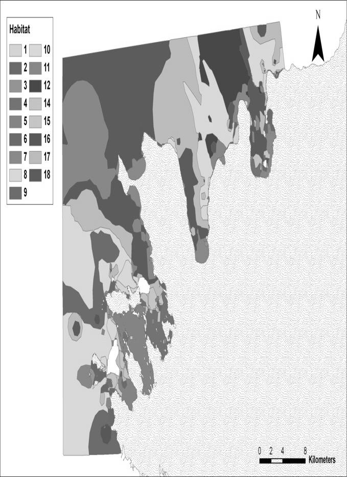
16 Distribution of benthic habitats in Nõva Osmussaar SCA


17 Results of habitat inventories EST
18 Results of habitat inventories EST EST1 EST2 EST3 EST4 EST5 EST6 Habitat Area, km2 % Area, km2 % Area, km2 % Area, km2 % Area, km2 % Area, km2 % total Annex I Habitat Code EST 1 EST 2 EST 3 EST 4 EST 5 EST 6 Reefs Sandbanks Mudflats & sandflats Large shallow bays Coastal lagoons Estuaries


19 Results of habitat inventories LAT Data source - IAE
20 Results of habitat inventories LAT Project territory 11 LAT Habitats Nr. Area, km 2 % Exposed hard bottoms with Furcellaria lumbricalis ,35 Exposed hard bottoms with Balanus improvisus ,11 Exposed hard bottoms with Mytilus trossulus and Balanus improvisus ,66 Exposed soft bottoms with Macoma balthica ,52 Exposed soft bottoms with the polychaetes Pygospio elegans and Marenzelleria neglecta ,94 Exposed soft bottoms with mobile amphipods , Reefs 238,7 49,22 Project territory 8 LAT Habitats Nr. Area, km 2 % Moderately exposed hard bottoms with Fucus vesiculosus 8 42,97 3,35 Moderately exposed hard bottoms with no particular species dominance 11 52,7 4,11 Moderately exposed hard bottoms with bivalves and Balanus improvisus 10 98,19 7,66 Moderately exposed soft bottoms with bivalves ,56 46,52 Moderately exposed soft bottoms with no particular species dominance ,54 37,94 Moderately exposed soft bottoms with higher plants excluding Zostera marina 14 5,48 0, , Reefs 73,93 5,76 Data source - IAE


21 Results of habitat inventories LIT LIT12 LIT13 Habitat Area,km2 % Area,km2 % total Data source - CORPI

22 Benthic mapping and inventories projects Year Area, km


23 Areas covered by benthic inventories/ mapping projects status of end of km 2
24 Preliminary results benthic mapping/inventories of Estonian coastal waters By end of 2009 more than 9000 km 2 (more than 1/3) of territorial waters have been covered by mapping/inventory activities 7 species of invertebrates discovered or rediscovered for Estonian waters Distribution range of different macroalage is updated Data on depth distribution of maroalgae is updated Habitat type Area km2 Importance % 1110 (sandbanks) 2018,18 22, (estuaries) 146,71 1, (mudflats) 302,95 3, (lagoons) 29 0, (Inlets) 140,54 1, (Reefs) 802,95 8,8181 Detailed information on substrate quality for many areas is specified
 Abundance (ind. m - 2 ) Depth (m) Species First record (year) No. of samples Min Max Mean Min Max Mean Min Max Mean Sediment Gammarus tigrinus 2003 350 <0.001 12.")
25 New findings of species 1 Echinogammarus stoerensis, 2 Pontogammarus robustoides, 3 Melita palmata, 4 Calliopius laeviusculus (*historical records from 1963), 5 Paramysis intermedia, 6 Chelicorophium curvispinum. Biomass (g dw m - 2 ) Abundance (ind. m - 2 ) Depth (m) Species First record (year) No. of samples Min Max Mean Min Max Mean Min Max Mean Sediment Gammarus tigrinus < sand, silt Chelicorophium sand, curvispinum < pebbles Pontogammarus robustoides < sand, pebbles Paramysis intermedia < sand Echinogammarus stoerensis rock Calliopius laeviusculus 2006* rock, pebbles Melita palmata rock, sand
26 Most important achievements and conclusions Large sections of territorial waters of EST, LAT and LIT were mapped for first time! Classification system for benthic habitats was created and used New mapping technique based on combination of UW video sampling and traditional methods was created and used. Great amount of new information is collected (distribution of species, habitats, conservation status) Future challenges: Development of capabilty of underwater video sampling at depths over 40 m and offshore. Further development of habitat modelling techniques (less field data more reliable modelling results) Mapping of remaining existing Natura areas in Application of new remote sensing techniques (e.g. Sonar) Development of water quality and state of biodiversity indicators based on spatial characteristics of benthic communities/habitats
Possibilities of LIDAR in the shallow waters of the Baltic Sea and it s application for habitat modeling
 Possibilities of LIDAR in the shallow waters of the Baltic Sea and it s application for habitat modeling Michael Haldin Natural Heritage Services / Metsähallitus Markku Viitasalo SYKE BACKGROUND LIDAR
Infaunal communities of Baltic upper circalittoral sand not dominated by bivalves
 European Red List of Habitats Marine: Baltic Habitat Group Infaunal communities of Baltic upper circalittoral sand not dominated by bivalves Summary This habitat is typical of upper circalittoral sand
Country Fiche Estonia
 Country Fiche Estonia Updated October 2017 1. General information Size of internal waters (to the baseline) and territorial sea (12-nm zone from the baseline) approximately 25 200 km 2. Exclusive economic
Annual algae communities on Baltic infralittoral coarse sediment
 European Red List of Habitats Marine: Baltic Sea Habitat Group Annual algae communities on Baltic infralittoral coarse sediment Summary This habitat is found in all the Baltic Sea subbasins and is especially
FINMARINET: Inventories and Planning for the Marine Natura 2000 Network in Finland. A.2 Geological inventories of the seafloor Final Report
 LIFE07 NAT/FIN/000151 FINMARINET: Inventories and Planning for the Marine Natura 2000 Network in Finland A.2 Geological inventories of the seafloor Final Report Geological Survey of Finland, GTK 1. Introduction
HELCOM work on development of Baltic MPA network
 W 2/5 Linking maritime spatial planning with marine protected areas (Baltic SCOPE) HELCOM work on development of Baltic MPA network Markku Viitasalo 1, Jan Ekebom 2, Penina Blankett 3 & Leena Laamanen
Country Fiche Estonia
 Country Fiche Estonia Deleted: October Updated May 2018 Deleted: 7 1. General information Size of internal waters (to the baseline) and territorial sea (12-nm zone from the baseline) approximately 25 200
Crustose algae communities on Baltic infralittoral rock and mixed substrata
 European Red List of Habitats Marine: Baltic Habitat Group Crustose algae communities on Baltic infralittoral rock and mixed substrata Summary This benthic habitat is present throughout the Baltic where
Infaunal communities in Baltic infralittoral muddy sediment not dominated by bivalves
 European Red List of Habitats Marine: Baltic Habitat Group Infaunal communities in Baltic infralittoral muddy sediment not dominated by bivalves Summary This habitat occurs in shallow areas in all the
Unvegetated epifaunal communities on Baltic infralittoral coarse sediment
 European Red List of Habitats Marine: Baltic Habitat Group Unvegetated epifaunal communities on Baltic infralittoral coarse sediment Summary This habitat occurs in all the Baltic Sea subbasins although
A proposed biotope classification system for the Baltic Sea
 Kartering av A proposed biotope classification system for the Baltic Sea Sofia A. Wikström, Darius Daunys and Jouni Leinikki S T O C K H O L M, 16 D E C E M B E R 2 0 1 0 Title: A proposed biotope classification
The Problem. Which ecosystems are the most sensitive? Where will ecosystems be migrating? Where will investments be overwhelmed?
 BC Parks BC Parks is responsible for the designation, management and conservation of a system of ecological reserves, provincial parks and recreation areas located throughout the province. British Columbia
Benthic habitat mapping: a synopsis of methodologies and approaches. Dr. Craig Brown University of Ulster
 Benthic habitat mapping: a synopsis of methodologies and approaches Dr. Craig Brown University of Ulster Technological advances in remote sensing Insitu sampling Improving technology Single beam acoustics/video
Environmental impact assessment study of the new offshore dumping sites for Šventoji port in Lithuania
 Environmental impact assessment study of the new offshore dumping sites for Šventoji port in Lithuania Introduction Summary In 2003 Lithuanian Ministry of Transport initiated the preparation of feasibility
Technologies for sea bottom inhabitants' monitoring and Integral Costal Zones Management. Example of the Kandalaksha Bay, White Sea
 Technologies for sea bottom inhabitants' monitoring and Integral Costal Zones Management. Example of the Kandalaksha Bay, White Sea Mikhail Tokarev, Roman Pevzner Transfer Technology Office of Lomonosov
Structure of coastal marine biotopes
 PREHAB PhD course - a multidisciplinary introductory course on ecological mapping and economic valuation of coastal areas 22.02.-03.03.2011 Husö Biological station, Åland islands, Finland Structure of
Leibniz Institute for Baltic Sea Research Warnemünde (Germany)
") Leibniz Institute for Baltic Sea Research Warnemünde (Germany) C r u i s e R e p o r t r/v "Poseidon" Cruise No. P 475 This report based on preliminary data and results Institut für Ostseeforschung Warnemünde
Leibniz Institute for Baltic Sea Research Warnemünde (Germany) C r u i s e R e p o r t r/v "Poseidon" Cruise No. P 475 This report based on preliminary data and results Institut für Ostseeforschung Warnemünde
WP4: COASTAL PROCESSES
 WP4: COASTAL PROCESSES Coordinator: G. EBERHARDS Faculty of Geography and Earth Sciences, University of Latvia Daugavpils, 2008 Goal: The objective of this study is analysis of coastal changes and forecast
Eutrophication (H01.05), Contaminant pollution (H01.05), Contaminant pollution (H03),
, Contaminant pollution (H01.05), Contaminant pollution (H03),") English name: Code in HUB: Submarine structures made by leaking gases 1180 Characteristic species: Polycirrus norwegicus, Kellia suborbicularis Past and Current Threats (Habitat directive Future Threats
English name: Code in HUB: Submarine structures made by leaking gases 1180 Characteristic species: Polycirrus norwegicus, Kellia suborbicularis Past and Current Threats (Habitat directive Future Threats
Current and Future Technology Applications for Coastal Zone Management. Bruce K. Carlisle, Acting Director Office of Coastal Zone Management
 Current and Future Technology Applications for Coastal Zone Management Bruce K. Carlisle, Acting Director Office of Coastal Zone Management The Massachusetts Coastal Zone Management Program Approved in
Klints Bank and North East of Gotland
 2014 1 BALTIC SEA PROJECT Oceana proposal for a Marine Protected Area Introduction Klints Bank is an offshore bank in the middle of the Baltic Proper, located about 50 km to the east of Gotland. This eastern
HELSINKI COMMISSION Baltic Marine Environment Protection Commission
 HELSINKI COMMISSION Baltic Marine Environment Protection Commission HELCOM RECOMMENDATION 24/10 Adopted 25 June 2003, having regard to Article 20, Paragraph 1 b) of the 1992 Helsinki Convention IMPLEMENTATION
Food for thoughts. Jon Davies MESH Project Coordinator
 Food for thoughts Jon Davies MESH Project Coordinator You are not alone.. There is someone out there.. Habmap UKSeaMap MESH Why is he here? Introduce the MESH Project, give a brief overview of other marine
Spatial variation in the abundance of eelgrass (Zostera marina) at eight sites in western Newfoundland, Canada 5/5/2015 V2.0
 at eight sites in western Newfoundland, Canada 5/5/2015 V2.0") Spatial variation in the abundance of eelgrass (Zostera marina) at eight sites in western Newfoundland, Canada 5/5/2015 V2.0 1 Summary The abundance of eelgrass (Zostera marina) was quantified at eight
Spatial variation in the abundance of eelgrass (Zostera marina) at eight sites in western Newfoundland, Canada 5/5/2015 V2.0 1 Summary The abundance of eelgrass (Zostera marina) was quantified at eight
Create your own map for tidepooling, beach field trips, boating, camping, kayaking, fishing, and exploring the beaches in Southcentral Alaska.
 Create your own map for tidepooling, beach field trips, boating, camping, kayaking, fishing, and exploring the beaches in Southcentral Alaska. Here s an opportunity to download and customize your own free
American Harris mud crab Rhithropanopeus harrisii
 American Harris mud crab Rhithropanopeus harrisii (Gould, 1841) in the Gulf of Gdańsk (southern Baltic Sea): distribution, population structure and basic physiological processes Joanna Hegele-Drywa Alien
Using seascapes to help predict Australia s benthic marine habitat diversity in the development of a national system of marine protected areas
 Using seascapes to help predict Australia s benthic marine habitat diversity in the development of a national system of marine protected areas A.D. Heap 1, T. Whiteway 1, V. Lucieer 2, S. Nichol 1 1. Geoscience
Mapping of marine habitats in shallow coastal areas in Denmark
 6 th Workshop Seabed Acoustics, Rostock, November 14/15, 2013 P11-1 Mapping of marine habitats in shallow coastal areas in Denmark Dr. Zyad Al-Hamdani Geological Survey of Denmark and Greenland - GEUS
Biogeographic Approach to Coastal Assessments & Spatial Planning
 NOAA s Biogeographic Approach to Coastal Assessments & Spatial Planning Mark E. Monaco Mark.Monaco@noaa.gov Center for Coastal Monitoring and Assessment http://ccma.nos.noaa.gov/about/biogeography Biogeography
E x a m p l e s o f t o o l s f o r s e a s i t u a t i o n a l a w a r e n e s s u s i n g C M E M S d a t a. Copernicus EU
 E x a m p l e s o f t o o l s f o r s e a s i t u a t i o n a l a w a r e n e s s u s i n g C M E M S d a t a Copernicus EU Copernicus EU Copernicus EU www.copernicus.eu S e a S i t u a t i o n a l A w
BURGAS CASE STUDY: LAND-SEA INTERACTIONS. Dr. Margarita Stancheva
 BURGAS CASE STUDY: LAND-SEA INTERACTIONS Dr. Margarita Stancheva Name of presentation NEED FOR COHERENCE BETWEEN LAND AND SEA ACTIVITIES Name presenter Burgas is the fourth largest city in Bulgaria and
BALANCE WP4: Development of a Baltic Sea marine area management framework. - with key inputs from WP1, WP2 & WP3
 BALANCE WP4: Development of a Baltic Sea marine area management framework - with key inputs from WP1, WP2 & WP3 BALANCE Kick-Off meeting, Copenhagen, 31 Aug-1 Sept 2005 Contents of the presentation: 1.
Significant Ecological Marine Area Assessment Sheet
 Significant Ecological arine Area Assessment Sheet Name: Eastern Bay of Island Biogenic Soft Sediment Complex Summary: The semi-sheltered areas between the central islands of the Eastern Bay of Islands
Natura 2000 in the marine environment: state of implementation and next steps
 Life on the blue planet: biodiversity research and the new European marine policies EPBRS European Platform on Biodiversity Research Strategy Porto, Portugal 7-9 November 2007 Natura 2000 in the marine
US ARMY CORPS OF ENGINEERS New England District BUILDING STRONG
 US ARMY CORPS OF ENGINEERS New England District STUDIES Sediment Sampling Biological Sampling (benthic community analysis) Hydroacoustic Surveys (side scan sonar, bathymetry) Remotely Operated Vehicle
Joint Federal Agency Submerged Aquatic Vegetation Survey Guidance for the New England Region Updated August 11, 2016
 Joint Federal Agency Submerged Aquatic Vegetation Survey Guidance for the New England Region Updated August 11, 2016 FOREWORD This guidance is the result of on-going interagency collaboration between the
Introduction: The Gulf of Mexico Alliance. The Gulf GAME project MERMAid and PHINS Results & Conclusions What s next? Examples
 AAG Las Vegas March 25, 2009 Introduction: Ocean governance and Ecosystem-Based Management The Gulf of Mexico Alliance Habitat Identification and Characterization The Gulf GAME project MERMAid and PHINS
BalticBOOST Appendix 1, WP 3.3 Deliverable 1 Final report 14 February 2017
 Theme 1: Biodiversity This is a deliverable from the BalticBOOST project that was coordinated by HELCOM and co-financed by the European Union in 2015-2016 as part of the programme DG ENV/MSFD Action Plans/2016.
HELCOM-VASAB Maritime Spatial Planning Working Group Twelfth Meeting Gdansk, Poland, February 2016
 HELCOM-VASAB Maritime Spatial Planning Working Group Twelfth Meeting Gdansk, Poland, 24-25 February 2016 Document title HELCOM database for the coastal and marine Baltic Sea protected areas (HELCOM MPAs).
Keywords: Wind resources assessment, Wind maps, Baltic Sea, GIS
 Advanced Materials Research Online: 2013-10-31 ISSN: 1662-8985, Vol. 827, pp 153-156 doi:10.4028/www.scientific.net/amr.827.153 2014 Trans Tech Publications, Switzerland Mapping of Offshore Wind Climate
French Seagrass indicator - Atlantic and Channel CW & TW NEA GIG
 French Seagrass indicator - Atlantic and Channel CW & TW NEA GIG Scientific team Isabelle Auby, Ifremer Arcachon Hélène Oger-Jeanneret, Ifremer Nantes Pierre-Guy Sauriau, CNRS, LIENSs Christian Hily, CNRS,
Mapping of marine ecosystems and their services in the Bulgarian Black Sea region. Evaluation of current condition
 Mapping of marine ecosystems and their services in the Bulgarian Black Sea region. Evaluation of current condition V. Karamfilov, D. Berov, V. Biserkov, G. Daskalov, S. Klayn,Y. Biserkov- IBER-BAS V. Todorova,
Case Study: Bulgarian part of the Black Sea
 Application of the MESMA Framework. Case Study: Bulgarian part of the Black Sea Schipper C.A. 1 Todorova V. 2, Doncheva V. 2 1 Deltares, P.O.Box 177, 2600 MH Delft, The Netherlands 2 Institute of Oceanology
Offshore Video Survey and Oceanographic Analysis: Georges Bank to the Chesapeake project
 Non-Technical Synopsis of the Offshore Video Survey and Oceanographic Analysis: Georges Bank to the Chesapeake project Executive Summary Dave Bethoney Kristin Kleisner Mark Anderson Changsheng Chen Bradley
Habitat Mapping in The Hauraki Gulf Marine Park. Dan Breen
 Habitat Mapping in The Hauraki Gulf Marine Park Dan Breen Outline 1. Intro Habitat mapping 2. Coastal marine habitats and marine protected areas in the New Zealand Territorial Sea: a broad scale gap analysis
Marine Spatial Planning as an important tool for implementing the MSFD
 Marine Spatial Planning as an important tool for implementing the MSFD Risto Kalliola Tallinn, Nov. 16 th 2012 DEPARTMENT OF GEOGRAPHY AND GEOLOGY University of Turku, Finland Ten principles to provide
Restoration of a boulder reef in Kattegat a numerical study of the design parameters and impact on sediment transport
 Restoration of a boulder reef in Kattegat a numerical study of the design parameters and impact on sediment transport S. Niemann, K. Bundgaard, et. al. DHI Water Environment Health, Denmark Boulder reef
Bob Van Dolah. Marine Resources Research Institute South Carolina Department of Natural Resources
 Bob Van Dolah Marine Resources Research Institute South Carolina Department of Natural Resources Shoreline Change Will Occur! On our front beaches where it is not easy to retreat Shoreline Change Will
Modeling habitat suitability for the European green crab using the ShoreZone mapping system
 Modeling habitat suitability for the European green crab using the ShoreZone mapping system Jodi N. Harney, Ph.D. and John R. Harper, Ph.D. Coastal and Ocean Resources Inc. Mary Morris, R.P. Bio. Archipelago
Biotope classification of Swedish zoobenthos data for the Baltic EUNIS
 AquaBiotaa Notes 2011:4 Biotope classification of Swedish zoobenthos data for the Baltic EUNIS Author: Johan Näslund AquaBiota Water Research September 2011 1 STOCKHOLM, 14 SEPTEMBER 2011 Title: Funding:
The Ecosystem Approach in Maritime Spatial Planning
 The Ecosystem Approach in Maritime Spatial Planning A Checklist Toolbox Finland Norway Helsinki Oslo Tallinn Stockholm Russia Estonia Sweden Riga Latvia Denmark Copenhagen Lithuania Vilnius Russia Gdansk
From seafloor geomorphology to predictive habitat mapping: progress in applications of biophysical data to ocean management.
 From seafloor geomorphology to predictive habitat mapping: progress in applications of biophysical data to ocean management. Peter T. Harris Geoscience Australia, Canberra ACT, Australia Currently seconded
Predicting drivers and distributions of deep-sea ecosystems: A cold-water coral case study
 3rd Science for the Environment Conference Aarhus, Denmark 1-2 October 2015 AARHUS UNIVERSITY Predicting drivers and distributions of deep-sea ecosystems: A cold-water coral case study Christian Mohn,
Bathymetry. EMODnet Stakeholder Conference & Sea-basin Workshops February Bathymetry
 EMODnet Stakeholder Conference & Sea-basin Workshops 14-15 February 2017 Arctic checkpoint Belinda Kater On behalf of all Checkpoints http://www.emodnet.eu 1 ? is the study of the "beds" or "floors" of
MESMA: An integrated tool box to support an ecosystem based spatial management of marine areas
 MESMA: An integrated tool box to support an ecosystem based spatial management of marine areas Stelzenmüller, V., Stamford, T., Vassilopoulou, V., Kastanevakis, S., Vincx, M, Vanaverbeke, J., Rabaut, M.,
Marine Spatial Planning: A Tool for Implementing Ecosystem-Based Management
 Marine Spatial Planning: A Tool for Implementing Ecosystem-Based Management Steven Murawski, Ph.D., Ecosystem Goal Team Lead National Oceanic and Atmospheric Administration NOAA November 16, 2009 1 To
Ecological mapping using satellite imagery: an Abu Dhabi case study Middle East Geospatial Forum 16 th February 2015
 Ecological mapping using satellite imagery: an Abu Dhabi case study Middle East Geospatial Forum 16 th February 2015 Richard Flemmings rf@proteusgeo.com About Proteus Formed in UAE 2011 We specialise in
The HELCOM Baltic Sea Action Plan and Marine Spatial Planning
 The HELCOM Baltic Sea Action Plan and Marine Spatial Planning Anne Christine Brusendorff Executive Secretary HELCOM The Baltic Sea Our common responsibility. Workshop on Integrated Sea Use management Stockholm
Theme 1, Working Group B: Conservation objectives for habitats Working Group reporting
 Theme 1, Working Group B: Conservation objectives for habitats Working Group reporting Annabelle Aish (MNHN) and Nicolas Fournier (Oceana) Marine Natura 2000 Biogeographical Kick-off seminar Working group
Country Fiche Lithuania
 Country Fiche Lithuania Updated June 2018 1. General information The Lithuanian maritime space is delimited by the Decree of the Government of the Republic of Lithuania of 6 December, 2004, No. 1597 and
Dynamic preservation of the coastline
 Dynamic preservation of the coastline Content Introduction The Dutch coastal defence by dynamic processes Data collection Management of the sand resources Growing importance of marine sand and gravel resources
SIF_7.1_v2. Indicator. Measurement. What should the measurement tell us?
 Indicator 7 Area of natural and semi-natural habitat Measurement 7.1 Area of natural and semi-natural habitat What should the measurement tell us? Natural habitats are considered the land and water areas
Marine benthic habitats of the George V Land shelf, Antarctica
 Marine benthic habitats of the George V Land shelf, Antarctica Linking geophysical and biological data in a polar environment Robin J. Beaman Project acknowledgements Geoscience Australia seismic profiles,
Marine habitat map of Northland: Mangawhai to Ahipara
 Marine habitat map of Northland: Mangawhai to Ahipara Version 1 April 2009 Vince Kerr Published by Department of Conservation P.O. Box 842 Whangarei 0140, New Zealand This report was prepared by Vince
Seagrass research & ecosystem services
 PROTECTING DUGONGS CONSERVING SEAGRASS CHANGE FOR COMMUNITIES Seagrass research & ecosystem services INCEPTION WORKSHOP THE GEF DUGONG AND SEAGRASS CONSERVATION PROJECT 20-21 October 2015 Colombo, Sri
Confidence Assessment Scoring System
 Confidence Assessment Scoring System Confidence field Confidence group Confidence question Comments Remote sensing data collection RemoteTechnique Were the techniques used appropriate for the ground type?
Bayesian inference for predicting potential oil spill related ecological risk
 Safety and Security Engineering III 149 Bayesian inference for predicting potential oil spill related ecological risk R. Aps 1, M. Fetissov 1, K. Herkül 1, J. Kotta 1, R. Leiger 1, Ü. Mander 2 & Ü. Suursaar
Summary Report. 7-8 November, 2013 Sports Complex of the Central Sports Club of the Army, Severnyi mol 7 Baltiysk, Kaliningrad Oblast Region, Russia
 RU LT Transnational stakeholders meeting on the concept for maritime spatial planning in the Lithuanian Sea and its potential impacts on sea use in Russia 7-8 November, 2013 Sports Complex of the Central
Country Fiche Latvia Updated October 2016
 Country Fiche Latvia Updated October 2016 1. General information Marine area under Latvian jurisdiction includes inland sea waters, Territorial sea (12 nautical miles from the baseline) and exclusive economic
Spatial Planning in Canada s Maritimes Region. Maritimes Region
 Spatial Planning in Canada s Maritimes Region Glen Herbert, Scott Coffen-Smout Smout,, and Tanya Koropatnick Oceans and Coastal Management Division Ecosystem Management Branch Fisheries and Oceans Canada
Setting Priorities for Eelgrass Conservation and Restoration. Robert Buchsbaum Massachusetts Audubon Society
 Setting Priorities for Eelgrass Conservation and Restoration Robert Buchsbaum Massachusetts Audubon Society Eelgrass habitat values A rich, productive habitat for many marine organisms Nursery habitat
The European Marine Observation and Data Network. EU-China Blue Year Event 1 June,
 The European Marine Observation and Data Network EU-China Blue Year Event 1 June, 2017 secretariat@emodnet.eu info@emodnet.eu There is only one Earth, with only one history, and we get only one chance
Sediment classification from multibeam backscatter images using simple histogram analysis
 Sediment classification from multibeam backscatter images using simple histogram analysis Rozaimi Che Hasan 1,2, Mohd Razali Mahmud 3 and Shahrin Amizul Shamsudin 1 1 UTM Razak School of Engineering and
BOEM Marine Minerals Program
 BOEM Marine Minerals Program Restoring and Protecting Our Nation s Coasts through Stewardship of OCS Sand Resources SECOORA 2018 Annual Meeting May 22-24 Doug Piatkowski Douglas.piatkowski@boem.gov 703-787-1833
GIS USE IN THE STUDY OF ESTUARINE SOILS AND SEDIMENTS Margot K. Payne NRS 509 November 30, 2005
 GIS USE IN THE STUDY OF ESTUARINE SOILS AND SEDIMENTS Margot K. Payne NRS 509 November 30, 2005 Throughout the world, estuaries are not only some of the most ecologically productive environments, but are
3 ECOLOGICAL ZONATION
 Marine Biology Section University Gent S. Degraer, W. Willems, E. Adriaens 1 & M. Vincx 3 ECOLOGICAL ZONATION 3.1 INTRODUCTION Due to its ecological importance and obvious presence within the marine ecosystem,
Copernicus for Coastal Zone Monitoring and Management
 Copernicus for Coastal Zone Monitoring and Management DG-Grow, 29 June 2017 User Requirement Perspective: Monitoring of coastal zones, pressures and impacts on nature and people Courtesy: J. Ekebom storm
The Use of Remote Sensing and GIS in MPA Delineation and Management
 Claire Hodson The Use of Remote Sensing and GIS in MPA Delineation and Management Marine Protected Areas (MPAs) are often defined as clearly distinct geographical space, recognized, dedicated and managed,
The Arctic - A New Frontier The geological, environmental and engineering challenges for submarine telecommunication cables
 The Arctic - A New Frontier The geological, environmental and engineering challenges for submarine telecommunication cables Ryan Wopschall 5 September 2013 Oceanology International China, Shanghai Fugro
Opening their Shells Getting commercial clammers involved in marine spatial planning
 Opening their Shells Getting commercial clammers involved in marine spatial planning Ed Lewandowski Coastal Communities Development Specialist University of Delaware/Delaware Sea Grant Highlights Background
An Arctic Perspective NCEI's Prototype Arctic Data Viewer
 An Arctic Perspective NCEI's Prototype Arctic Data Viewer NCEI Arctic Action Team Kate Rose NOAA National Environmental Satellite, Data, and Information Service National Centers for Environmental Information
Relatively little hard substrate occurs naturally in the
 CHAPTER FIVE Rock Habitats Relatively little hard substrate occurs naturally in the estuary, owing mainly to the vast quantities of fine sediment that have been deposited by the rivers. Rock habitat is
HELCOM Red List Category: Previous HELCOM Red List threat assessments BSEP 75 (HELCOM 1998): BSEP 113 (HELCOM 2007): Greater concern stated by:
: BSEP 113 (HELCOM 2007): Greater concern stated by:") English name: Code in HELCOM HUB: Baltic Sea seasonal sea ice AC Characteristic species: Phytoplankton (diatoms, autotrophic flagellates, dinoflagellates), heterotrophic bacteria, zooplankton (heterotrophic
English name: Code in HELCOM HUB: Baltic Sea seasonal sea ice AC Characteristic species: Phytoplankton (diatoms, autotrophic flagellates, dinoflagellates), heterotrophic bacteria, zooplankton (heterotrophic
Marine Spatial Planning Leslie-Ann McGee Battelle Memorial Institute
 Marine Spatial Planning Leslie-Ann McGee Battelle Memorial Institute Rev061708 1 Marine Spatial Planning What is it? Why is it different? Where is it currently being employed? What is happening in the
Aarno Kotilainen, The Geological Survey of Finland Anu Reijonen, The Geological Survey of Finland. Open
 Title BALANCE Cruise Report: The Archipelago Sea, 18/7 18/8 2006 BALANCE Interim Report No. 6 Editors Aarno Kotilainen, The Geological Survey of Finland Anu Reijonen, The Geological Survey of Finland Date
Marine ecosystem mapping at the Prince Edward Islands
 Marine ecosystem mapping at the Prince Edward Islands Biodiversity Planning Forum NBA special session June 2018 R Adams, C von der Meden, A Dayaram, K Sink, A Lombard, A Bosman, M Dopolo, F Fourie, L Harris,
Risks to Estuarine Biota under Proposed Development in the Whitford Catchment Summary Report
 Risks to Estuarine Biota under Proposed Development in the Whitford Catchment Summary Report August 2003 TP204 Auckland Regional Council Technical Publication No. 204, 2003 ISSN 1175-205X ISBN -1-877353051
Multiple methods, maps, and management applications: purpose made maps in support of Ocean Management. Craig J. Brown McGregor GeoScience Ltd.
 Multiple methods, maps, and management applications: purpose made maps in support of Ocean Management Craig J. Brown McGregor GeoScience Ltd. International workshop on seabed mapping methods and technology,
A new fauna intercalibration typology
 A new fauna intercalibration typology WFD Intercalibration - 2nd phase - Baltic GIG Auftraggeber: Landesamt für Natur und Umwelt Schleswig-Holstein Hamburger Chaussee 25 24220 Flintbe Author: Torsten Berg
Nature and Nurture of the Northern Baltic Sea. Velmu-seminar Sonja Jaari
 Nature and Nurture of the Northern Baltic Sea Velmu-seminar 15.4.2010 Sonja Jaari Sonja.Jaari@novia.fi Background The Northern Baltic is a shallow nutrient rich area made up of a mosaique of islands and
BIOTOPE INFORMATION SHEET
 English name: Baltic photic muddy or coarse sediment, sand or mixed substrate dominated by Charales Code in HELCOM HUB: AA.H1B4, AA.I1B4, AA.J1B4, AA.M1B4 Characteristic species: Chara aspera, Chara canescens,
Marine Ecology Pacing Guide
 Marine Ecology Pacing Guide Course Description: The focus of the course is the interrelationships among marine organisms and the physical, chemical, geological and biological factors. North Carolina coastal
Programme. International workshop on seabed mapping methods and technology, Trondheim 17 th -18 th October 2012
 Programme International workshop on seabed mapping methods and technology, Trondheim 17 th -18 th October 2012 WEDNESDAY 17 TH OCTOBER Introductory talks seabed mapping for ocean management international
Co-Financed Under European Integrated Maritime Policy
 Co-Financed Under European Integrated Maritime Policy PLAN BOTHNIA MSP 3/2011 PLAN BOTHNIA MSP 3 Helsinki, Finland, October 19-20, 2011 Agenda Item 3 The PLAN BOTHNIA MSP Assessment Document code: 3/5
Weekly summary of Tropic101x as posted by student Lucia_Agudelo
 Weekly summary of Tropic101x as posted by student Lucia_Agudelo With minor grammatical and content edits by Tropic101x team Summary of Week 6 FIELD METHODS LECTURE 6.1.1 Being able to measure the distribution,
RED LIST OF EUROPEAN HABITATS. Marine Results Presentation 24 th May, 2016
 RED LIST OF EUROPEAN HABITATS Marine Results Presentation 24 th May, 2016 Geographical scope of the project Habitat Typology One typology for marine and terrestrial At the same time... revision of EUNIS
Relationship between gas-bearing (?) sediments and biogenic mounds in the Kalloni Gulf, Lesvos Island, Greece
 sediments and biogenic mounds in the Kalloni Gulf, Lesvos Island, Greece") 6 th Workshop Seabed Acoustics, Rostock, November 14/15, 2013 P13-1 Relationship between gas-bearing (?) sediments and biogenic mounds in the Kalloni Gulf, Lesvos Island, Greece Alexandros Chronis, Dr.
6 th Workshop Seabed Acoustics, Rostock, November 14/15, 2013 P13-1 Relationship between gas-bearing (?) sediments and biogenic mounds in the Kalloni Gulf, Lesvos Island, Greece Alexandros Chronis, Dr.
BIOLOGICAL OCEANOGRAPHY
 BIOLOGICAL OCEANOGRAPHY AN INTRODUCTION 0 ^ J ty - y\ 2 S CAROL M. LALLI and TIMOTHY R. PARSONS University of British Columbia, Vancouver, Canada PERGAMON PRESS OXFORD NEW YORK SEOUL TOKYO ABOUT THIS VOLUME
Using remote-sensed data for quantitative shallow water habitat mapping in New Zealand
 Using remote-sensed data for quantitative shallow water habitat mapping in New Zealand Friday 24 February 2012 Geoffroy Lamarche National Institute of Water and Atmospheric Research Wellington with substantial
Inspire Conference Istanbul, 2012 Ralf Lindgren. Inspire Conference Istanbul, 2012 Ralf Lindgren
 Background A Baltic Sea Bathymetry Database Concept and Hans Öiås Swedish Maritime Administration Hydrographic Office A national directive: The Swedish Maritime Administration shall, in cooperation with