Spatial Planning in Canada s Maritimes Region. Maritimes Region
|
|
|
- Willa Lawson
- 6 years ago
- Views:
Transcription
1 Spatial Planning in Canada s Maritimes Region Glen Herbert, Scott Coffen-Smout Smout,, and Tanya Koropatnick Oceans and Coastal Management Division Ecosystem Management Branch Fisheries and Oceans Canada Maritimes Region BIO Dartmouth, NS Agenda Introduction Challenges and opportunities for MSP in Canada DFO Maritimes Region s view of MSP Work to date Spatial conservation action plan On-going data collection and analysis Case studies: Spatial planning in practice Next steps
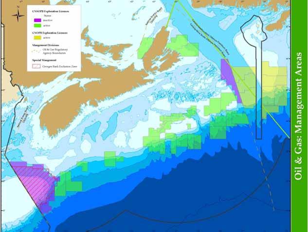
2 Challenges and Opportunities for MSP in Canada No federal oceans-related acts explicitly recommend or exclude the use of MSP DFO Minister has authority to implement MSP relative to MPAs, fisheries, aquaculture, habitat protection, and pollution prevention Other oceans-mandated Ministers have authority to implement MSP for maritime transport, cables, oil and gas exploration and development, ocean dumping, marine conservation areas, and marine wildlife areas etc. Collaborative approach is required due to multiple jurisdictions DFO Maritimes Region View of MSP MSP is a tool for collating information for assessment, monitoring, and reporting that supports informed decisions and actions for effective integrated management

3 Work on MSP in DFO Maritimes Region ESSIM spatial conservation action plan Data collection and analysis to support regionwide, long term MSP (e.g., MPA network planning) Human use atlas GIS decision support tool Small scale msp : Planning and coordination User-user conflicts User-environment conflicts Spatial Conservation Action Plan (SCAP) SCAP was one of the first action plans under the ESSIM strategic plan. The aim was to: Define and build common understanding of spatial conservation planning Synthesize existing information on areas of conservation value and existing sites Identify areas of convergence and perform gap analysis Build agreement on areas of conservation priority and suggest options/tools Inform ongoing initiatives (ex. MPA Action Plan) and steward implementation by relevant legislative authority or through community led conservation approaches

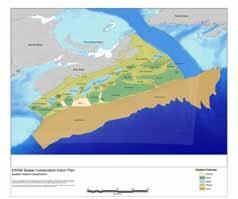
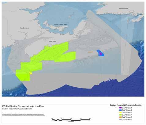
4 Gap Analysis Areas of conservation value Existing management areas (Big) gap analysis
 Seek to incorporate areas nominated by communities and resource users Seek to minimise total area protected while meeting objectives (find( areas with best bang for the buck ) Seek to")
5 Draft socio-economic principles for conservation planning Design a process in which stakeholders can see how their input is being used Plan at a regional scale (to maximise opportunities for meeting objectives) Seek to incorporate areas nominated by communities and resource users Seek to minimise total area protected while meeting objectives (find( areas with best bang for the buck ) Seek to minimise socio-economic impacts on resource users Seek opportunities to allow sustainable activities to occur while e meeting objectives Build on and enhance existing conservation measures where possible Select appropriate tool and level of protection for conservation need Don t focus only on where activities should be avoided; also look k for areas where certain uses are appropriate - how and when are key Spatial Data Collection / Analysis
6
7
8
9
10
 1995-2009 Spatial")


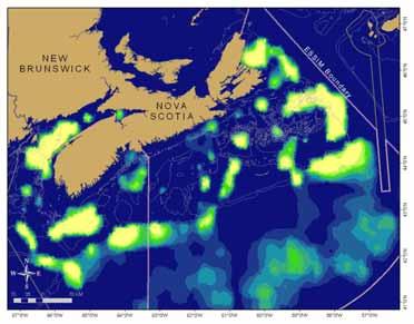
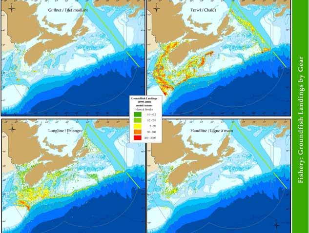
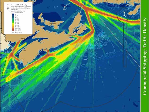
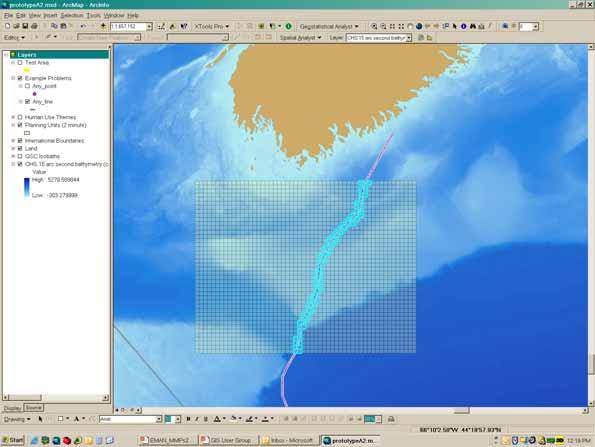
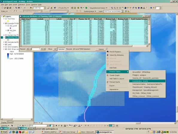
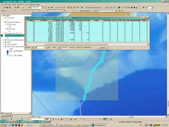
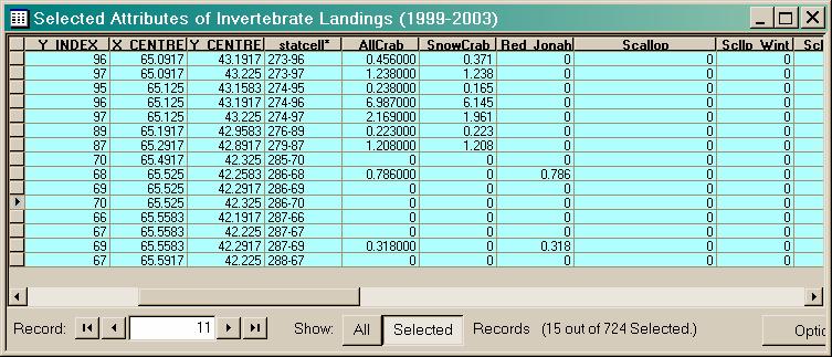
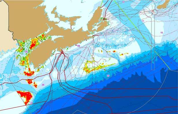
11 Highest intensity bottom trawls (all species) Highest intensity longline (all species) Spatial Data Collection / Analysis GISMO: GIS for Management of the Ocean Spatial decision support tool for integrated management and conservation planning Data in the geodatabase are aggregated based on planning units (2 minute grid cells for the offshore)
12
13
14
 in")
15 Case Studies: msp msp in Practice 1) User-user conflict: Submarine cables and fisheries interactions 2) User-environment environment conflict: Ballast water exchange near the Gully MPA 3) User-environment environment conflict: Fisheries and coral conservation Submarine Cables and Fisheries Interactions Recent submarine cables in Maritimes Region Hibernia Atlantic (NS-US US-Ireland) in 2000 Persona/Eastlink (NS-NL) NL) in 2007 Canada Express (NS-UK) in 2012 NS-NL NL energy cable by ? 16? Potential for lost fishery access and cable faults Established Joint Fisheries-Cables Industry Working Group 2005 Demonstrates: the importance of early information sharing the need to facilitate inter-governmental coordination for cable regulation and route planning

 DFO Science Branch estimates that, on")


16 Browns Bank Fishery Impacts Browns Bank Segment = 78.1 km Buried = 52.4 km (67.1%) Exposed = 25.7 km (32.9%) DFO Science Branch estimates that, on average,, 4.5% of the annual scallop biomass landed on Browns Bank ( ) is from the 1/2 nautical mile area straddling the cable route. Analysis of groundfish fishery indicates most overlap with <65 otter trawl gear. Canada Express Environmentally sensitive areas Crab landings Shrimp landings


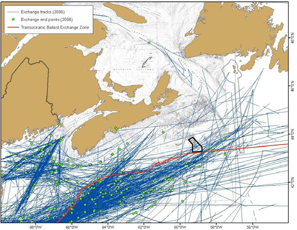
17 Ballast Exchange Near the Gully MPA
 Georges Bank")


 13 km Source: Dave")
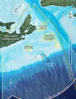
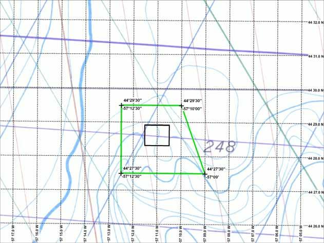
18 Fisheries and Coral Conservation Lophelia CCA (2004) Georges Bank Size: 15 km 2 Objective: Protect Lophelia pertusa reef Legislation: Fisheries Act closure Restrictions: No bottom fishing Historic Fisheries ( Trawler) 13 km Source: Dave Kulka, DFO-Newfoundland
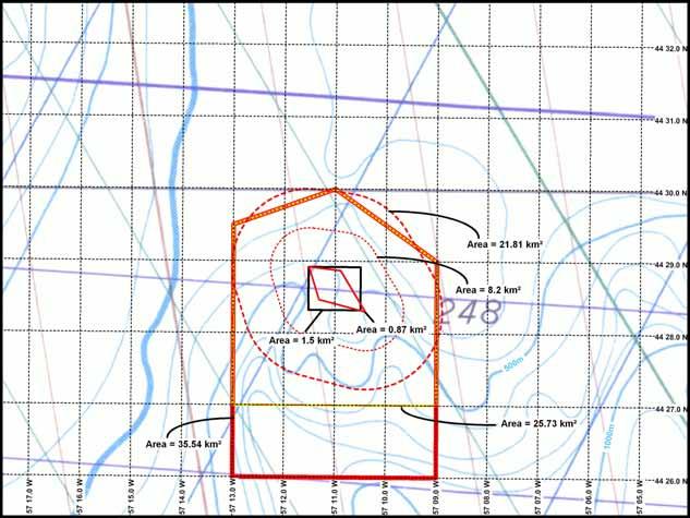
19 Proposed Boundaries Lophelia Closure
20 Next Steps Update / expand mapping of human activities in the region Work with industry and other subject-matter experts to verify the adequacy of spatial data and maps Communicate/share spatial information to regulators, industry, and the general public (e.g., multipurpose marine cadastre, georeferenced pdfs) Apply spatial analysis tools (e.g., spatial risk assessment, intensity of use metrics, cumulative impacts analyses, future scenarios modelling) to identify user-user and user-ecosystem conflicts and compatibilities in marine space Work with other regulatory authorities to coordinate sectoralbased spatial planning and regional environmental assessments Continue to update spatial information for adaptive management
Outline National legislative & policy context Regional history with ESSIM ESSIM Evaluation Phase Government Integration via RCCOM Regional ICOM Framew
 What MSP Implementation could change in the Maritimes Region Tim Hall, Regional Manager Oceans and Coastal Management Division Ecosystem Management Branch Fisheries and Oceans Canada Maritimes Region BIO
EASTERN SCOTIAN SHELF INTEGRATED OCEAN MANAGEMENT PLAN
 Government of Canada Gouvernement du Canada EASTERN SCOTIAN SHELF INTEGRATED OCEAN MANAGEMENT PLAN SUMMARY Photo Credits: Bedford Institute of Oceanography Published by: Oceans and Habitat Branch Fisheries
Designing Networks of Marine Protected Areas in DFO s Three Atlantic Bioregions
 Designing Networks of Marine Protected Areas in DFO s Three Atlantic Bioregions Presentation for Indigenous Protected Areas Workshop Max Westhead, DFO and Adrian Gerhartz-Abraham, Dalhousie March 29, 2017
DFO Maritimes Region Update. Gulf of Maine Council - Coastal and Marine Spatial Planning (CMSP) Committee Web-Ex May 16, 2017
 Committee Web-Ex May 16, 2017") DFO Maritimes Region Update Gulf of Maine Council - Coastal and Marine Spatial Planning (CMSP) Committee Web-Ex May 16, 2017 1 National Oceans Priorities Marine Conservation Targets Oceans Protection Plan
DFO Maritimes Region Update Gulf of Maine Council - Coastal and Marine Spatial Planning (CMSP) Committee Web-Ex May 16, 2017 1 National Oceans Priorities Marine Conservation Targets Oceans Protection Plan
REGIONAL OCEANS PLAN
 FISHERIES AND OCEANS CANADA MARITIMES REGION 2016 REGIONAL OCEANS PLAN SCOTIAN SHELF ATLANTIC COAST BAY OF FUNDY Progress Report 2014-2016 Fisheries and Oceans Canada Pêches et Océans Canada Implementing
MARINE SPATIAL PLANNING & MARINE CADASTRE: CHALLENGES AND ISSUES
 MARINE SPATIAL PLANNING & MARINE CADASTRE: CHALLENGES AND ISSUES Roger Longhorn Secretary General, GSDI Association rlonghorn@gsdi.org Member, IHO Marine SDI Working Group ral@alum.mit.edu Member, UNESCO
A TOOLKIT FOR MARINE SPATIAL PLANNING Version: 17 July, 2009
 A TOOLKIT FOR MARINE SPATIAL PLANNING Version: 17 July, 2009 NEED FOR MARINE SPATIAL PLANNING The health of marine ecosystems is declining, and use conflicts in the marine environment are increasing, in
TOWARDS CLIMATE-RESILIENT COASTAL MANAGEMENT: OPPORTUNITIES FOR IMPROVED ICZM IN BELIZE
 TOWARDS CLIMATE-RESILIENT COASTAL MANAGEMENT: OPPORTUNITIES FOR IMPROVED ICZM IN BELIZE CHANTALLE SAMUELS Coastal Zone Management Authority and Institute The Caribbean Community Climate Change Centre VULNERABILITY
A trans-atlantic assessment and deep-water ecosystem-based spatial management plan for Europe
 A trans-atlantic assessment and deep-water ecosystem-based spatial management plan for Europe This project has received funding from the European Union s Horizon 2020 research and innovation programme
Marine Spatial Planning: A Tool for Implementing Ecosystem-Based Management
 Marine Spatial Planning: A Tool for Implementing Ecosystem-Based Management Steven Murawski, Ph.D., Ecosystem Goal Team Lead National Oceanic and Atmospheric Administration NOAA November 16, 2009 1 To
BURGAS CASE STUDY: LAND-SEA INTERACTIONS. Dr. Margarita Stancheva
 BURGAS CASE STUDY: LAND-SEA INTERACTIONS Dr. Margarita Stancheva Name of presentation NEED FOR COHERENCE BETWEEN LAND AND SEA ACTIVITIES Name presenter Burgas is the fourth largest city in Bulgaria and
Marine Protected Area Network Planning in the Bay of Fundy and Scotian Shelf. Progress to date and next steps
 Marine Protected Area Network Planning in the Bay of Fundy and Scotian Shelf Progress to date and next steps Max(ine) Westhead, M.Sc. Section Head, Protected Areas and Conservation Planning Fisheries and
Dorset MSP Evidence Base 18 th February Ness Smith C-SCOPE Project Officer
 Dorset MSP Evidence Base 18 th February 2011 Ness Smith C-SCOPE Project Officer Sectoral Topic Papers MMA Description document gives an overview of the area, it s physical and human influences 20 Topic
Country Fiche Estonia
 Country Fiche Estonia Updated October 2017 1. General information Size of internal waters (to the baseline) and territorial sea (12-nm zone from the baseline) approximately 25 200 km 2. Exclusive economic
Country Fiche Lithuania
 Country Fiche Lithuania Updated June 2018 1. General information The Lithuanian maritime space is delimited by the Decree of the Government of the Republic of Lithuania of 6 December, 2004, No. 1597 and
GROUNDFISH AMENDMENT 28 REGULATION DEVELOPMENT UPDATE
 Agenda Item I.2.a NMFS Report 1 September 2018 GROUNDFISH AMENDMENT 28 REGULATION DEVELOPMENT UPDATE In drafting regulations for the Council s final preferred alternative for Amendment 28, recommended
Marine Spatial Planning (MSP): A practical approach to ecosystembased
: A practical approach to ecosystembased") Marine Spatial Planning (MSP): A practical approach to ecosystembased management Erik Olsen, Institute of Marine Research, Norway Fanny Douvere, International Oceanographic Commission Overview Why we need
Marine Spatial Planning (MSP): A practical approach to ecosystembased management Erik Olsen, Institute of Marine Research, Norway Fanny Douvere, International Oceanographic Commission Overview Why we need
Country Fiche Latvia Updated October 2016
 Country Fiche Latvia Updated October 2016 1. General information Marine area under Latvian jurisdiction includes inland sea waters, Territorial sea (12 nautical miles from the baseline) and exclusive economic
Maritime Spatial Planning in the Baltic Sea Region
 Maritime Spatial Planning in the Baltic Sea Region Talis Linkaits Head of VASAB Secretariat 20 May 2015 Helsinki A cooperation of ministers of the 11 Baltic Sea Region countries responsible for spatial
Ensuring Access to Marine Areas for Offshore Oil and Gas
 Ensuring Access to Marine Areas for Offshore Oil and Gas Paul Holthus Executive Director World Ocean Council paul.holthus@oceancouncil.org The international business alliance for Corporate Ocean Responsibility
6 th Meeting of the Scientific Committee Puerto Varas, Chile, 9-14 September 2018
 6 th Meeting of the Scientific Committee Puerto Varas, Chile, 9-14 September 2018 SC6-DW11 Methods for designing spatial management areas using outputs from Zonation software and other spatial data Martin
ICZM and MSP in the Black Sea Region
 ICZM and MSP in the Black Sea Region Drd. Claudia Coman, Environmental engineer AG ICZM Focal Point, Romania Black Sea Commission Black Sea Commission on the Protection of the Black Sea against Pollution
MARINE STUDIES (MARINE SPATIAL PLANNING & MANAGEMENT) MASTER S DEGREE
 MASTER S DEGREE") MARINE STUDIES (MARINE SPATIAL PLANNING & MANAGEMENT) MASTER S DEGREE Influence, lead and provide decision making support for the management and planning of coastal and marine spaces. PROGRAM DESCRIPTION
MARINE STUDIES (MARINE SPATIAL PLANNING & MANAGEMENT) MASTER S DEGREE Influence, lead and provide decision making support for the management and planning of coastal and marine spaces. PROGRAM DESCRIPTION
MSP Process drawings and descriptions
 MSP Process drawings and descriptions 12 December 2016 2 Table of Contents 1. Belgium... 3 2. The Netherlands... 5 3. Germany... 7 4. Denmark... 9 5. Scotland... 11 6. Sweden... 13 7. Norway... 15 1. Belgium
Maritime Spatial Planning Framework Directive Supported by INSPIRE
 Maritime Spatial Planning Framework Directive Supported by INSPIRE Andrej Abramić, Vanda Nunes de Lima, Paul Smits, Emanuele Bigagli, Chris Schubert European Commission Joint Research Centre Institute
Additional information (material for interactions and analysis chapter) to document 3/1, the PLAN BOTHNIA MSP Assessment
 to document 3/1, the PLAN BOTHNIA MSP Assessment") Co-Financed Under European Integrated Maritime Policy PLAN BOTHNIA MSP 2/2011 MSP Assessment Add 1 PLAN BOTHNIA MSP 2 Uppsala, Sweden June 14-15 2011 Agenda Item 3 PLAN BOTHNIA MSP Assessment Document
Co-Financed Under European Integrated Maritime Policy PLAN BOTHNIA MSP 2/2011 MSP Assessment Add 1 PLAN BOTHNIA MSP 2 Uppsala, Sweden June 14-15 2011 Agenda Item 3 PLAN BOTHNIA MSP Assessment Document
Country Fiche Estonia
 Country Fiche Estonia Deleted: October Updated May 2018 Deleted: 7 1. General information Size of internal waters (to the baseline) and territorial sea (12-nm zone from the baseline) approximately 25 200
FISHERIES AND OCEANS CANADA MARITIMES REGION 2014 REGIONAL OCEANS PLAN SCOTIAN SHELF ATLANTIC COAST BAY OF FUNDY. Background and Program Description
 FISHERIES AND OCEANS CANADA MARITIMES REGION 2014 REGIONAL OCEANS PLAN SCOTIAN SHELF ATLANTIC COAST BAY OF FUNDY Background and Program Description Fisheries and Oceans Canada Pêches et Océans Canada Fisheries
International Guidelines for Ecosystem-based, Marine Spatial Management
 International Guidelines for Ecosystem-based, Marine Spatial Management Charles Ehler and Fanny Douvere, Consultants Intergovernmental Oceanographic Commission and Man and the Biosphere Programme UNESCO
Offshore Energy and Maritime Spatial Planning in the German EEZ
 Offshore Energy and Maritime Spatial Planning in the German EEZ Bettina Käppeler, BSH Federal Maritime and Hydrographic Agency On Duty for Shipping and Seas German Exclusive Economic Zone EEZ not part
Implementation Status & Results Report Red Sea and Gulf of Aden Strategic Ecosystem Management GEF Project (P113794)
") Public Disclosure Authorized MIDDLE EAST AND NORTH AFRICA Middle East and North Africa Environment & Natural Resources Global Practice Global Environment Project Specific Investment Loan FY 2014 Seq No:
Public Disclosure Authorized MIDDLE EAST AND NORTH AFRICA Middle East and North Africa Environment & Natural Resources Global Practice Global Environment Project Specific Investment Loan FY 2014 Seq No:
Marine Spatial Planning in Hellas; Recent Facts and Perspectives
 XXV FIG CONGRESS Engaging the Challenges, Enhancing the Relevance Kuala Lumpur, Malaysia 16 21 June 2014 Marine Spatial Planning in Hellas; Recent Facts and Perspectives Mrs. Chaiditsa BOLANOU Surveying
Marine Spatial Planning, a Norwegian user case NSHC33
 Marine Spatial Planning, a Norwegian user case NSHC33 Marine Spatial Management Tool Support the marine spatial planning process with updated and reliable geospatial information Marine management is important
Introduction to IMP: need and added value
 Introduction to IMP: need and added value Christophe Le Visage Consultant Stratégies Mer et Littoral 1 Summary IMP : Why? The case for integration 1 What is IMP? 2 Content, process IMP: Added Value 3 2
Marine Spatial Planning in the Baltic Sea Region
 Marine Spatial Planning in the Baltic Sea Region Towards coherence and cross-border solutions in Baltic Maritime Spatial Plans Coordinator & Project manager Dr Ingela Isaksson Swedish Agency for Marine
NOAA Nautical Charts and Coastal and Marine Spatial Planning. Meredith Westington Chief Geographer NOAA/NOS/Office of Coast Survey
 NOAA Nautical Charts and Coastal and Marine Spatial Planning Meredith Westington Chief Geographer NOAA/NOS/Office of Coast Survey Ocean Policy Task Force What is CMSP? A comprehensive, adaptive, integrated,
Implementation of the Political Declaration on energy cooperation between the North Seas Countries. Support Group 1 on Maritime Spatial Planning
 Implementation of the Political Declaration on energy cooperation between the North Seas Countries Support Group 1 on Maritime Spatial Planning Work Programme 1. Work area as outlined in Annex I to the
BURGAS CASE STUDY: LAND-SEA INTERACTIONS
 BURGAS CASE STUDY: LAND-SEA INTERACTIONS Dr. Margarita Stancheva IO-BAS, Bulgaria Name of presentation CROSS BORDER MARITIME SPATIAL PLANNING IN THE BLACK SEA ROMANIA AND BULGARIA (MARSPLAN BS) Project
Evaluation of Spatial Planning as a Tool for Integrated Marine Management Status, Obstacles and Research Gaps
 Evaluation of Spatial Planning as a Tool for Integrated Marine Management Status, Obstacles and Research Gaps Baltic MSP Forum Riga 17.-18. June 2014 A. Morf & A. Grimvall: Swedish Institute for the Marine
1. Baltic SCOPE Towards coherence and cross-border solutions in Baltic Maritime Spatial Plans
 NSHC 32th Conference Explanatory Note Dublin, Ireland Item E.2 MSP 21-23 June 2016 Germany Cross border MSP for the EEZ, a case study from the Baltic Sea The Federal Maritime and Hydrographic Agency of
MARINE SPATIAL PLANNING
 MARINE SPATIAL PLANNING Washington Uses Spatial Planning to Honor its Pacific Coast and Offshore Waters Past, Present and Future The Washington State Pacific Coast and offshore waters are diverse in both
ALASKA DEEP-DRAFT ARCTIC PORT EVALUATION
 ALASKA DEEP-DRAFT ARCTIC PORT EVALUATION Joint Study of Federal and State June 20, 2012 Opportunity and Constraint Warming of Arctic region is leading to new maritime opportunities. Thawing of permafrost
Applying GIS to Coastal Management in Cork Harbour: the Corepoint experience
 Applying GIS to Coastal Management in Cork Harbour: the Corepoint experience Kathrin Köpke University College Cork, Ireland Thematic Conference: THE WATERFRONT MANAGEMENT AND GI (IT), 14 th -18 th November
Name/ Affiliation: Ben Enticknap, Fishery Project Coordinator Alaska Marine Conservation Council Address: PO Box Anchorage, AK 99510
 Habitat Areas of Particular Concern (HAPC) Proposal Name/ Affiliation: Ben Enticknap, Fishery Project Coordinator Alaska Marine Conservation Council Address: PO Box 101145 Anchorage, AK 99510 Please check
MALDIVES. Regional Expert Workshop On Land Accounting For SDG Monitoring & Reporting (25-27 th Sept 2017) - Fathimath Shanna, Aishath Aniya -
 - Fathimath Shanna, Aishath Aniya -") MALDIVES Regional Expert Workshop On Land Accounting For SDG Monitoring & Reporting (25-27 th Sept 2017) - Fathimath Shanna, Aishath Aniya - ABOUT MALDIVES Approximately 860 km long and 120 km wide Consists
MALDIVES Regional Expert Workshop On Land Accounting For SDG Monitoring & Reporting (25-27 th Sept 2017) - Fathimath Shanna, Aishath Aniya - ABOUT MALDIVES Approximately 860 km long and 120 km wide Consists
MARINE PLANNING IN THE NETHERLANDS
 MARINE PLANNING IN THE NETHERLANDS Hermien Busschbach Ministry of Transport, Public Works and Water Management (DG Water) Bremen, 2 May 2007 Marine Planning in the Netherlands OUTLINE policy context; international
COUNTRY REPORT: BELGIUM Marine Spatial Planning and the Protection of the Marine Environment in the Belgian Part of the North Sea
 Belgium: Marine Spatial Planning 144 COUNTRY REPORT: BELGIUM Marine Spatial Planning and the Protection of the Marine Environment in the Belgian Part of the North Sea Thary Derudder and Frank Maes Introduction
THE SEVILLE STRATEGY ON BIOSPHERE RESERVES
 THE SEVILLE STRATEGY ON BIOSPHERE RESERVES 1 VISION FOR BIOSPHERE RESERVES IN THE 21 ST CENTURY The international Seville Conference on Biosphere Reserves, organised by UNESCO, adopted a two-pronged approach,
Findings and recommendations from Central Baltic case
 W 1/1 Recommendations on transboundary planning from Baltic SCOPE Findings and recommendations from Central Baltic case Ingūna Urtāne Director of Spatial Planning Department of the Ministry of Environmental
Towards international cooperation in the development of Marine Spatial Plans for the North Pacific: economic, social, and environmental dimensions
 Towards international cooperation in the development of Marine Spatial Plans for the North Pacific: economic, social, and environmental dimensions A.V. Sereda, V.B. Lobanov V.I. Il ichev Pacific Oceanological
Possibilities for applying ES assessment results in spatial planning in Latvia
 Possibilities for applying ES assessment results in spatial planning in Latvia Inga Hoņavko LIFE EcosystemServices project manager LIFE Viva Grass seminar, Sigulda, 17.05.2018 Projekts LIFE EcosystemServices,
Identification of maritime spatial planning best practices in the Baltic Sea Region and other EU maritime regions
 Identification of maritime spatial planning best practices in the Baltic Sea Region and other EU maritime regions PLAN BOTHNIA Baltic Sea Region Stakeholder Meeting Jacek Zaucha, Magdalena Matczak Two
MARITIME PLANNING IN PORTUGAL
 MARITIME PLANNING IN PORTUGAL Marta Chantal Ribeiro 2 May 2007 In Portugal there is currently no strategic planning system in force for the maritime area as a whole The maritime area under Portuguese jurisdiction
Marine/Maritime Spatial Planning Andrej Abramić
 Marine/Maritime Spatial Planning Andrej Abramić EcoAqua SUMMER SCHOOL: Ecosystem approach to aquaculture 26-29th of October 2015 Research and Technology to enhance excellence in Aquaculture development
Using Data and Evidence to Inform Marine Spatial Planning
 Coastwatch Workshop and Launch of 30 years of Coastwatch Data Using Data and Evidence to Inform Marine Spatial Planning Stephen Hull Overview What is MSP? What is MSP trying to achieve? Ireland s MSP process
Why do we need a global framework for MPAs in ABNJ? Kristina M. Gjerde IUCN High Seas Policy Advisor
 Why do we need a global framework for MPAs in ABNJ? Kristina M. Gjerde IUCN High Seas Policy Advisor kgjerde@eip.com.pl 40% ocean heavily affected by humans (c) Halpern et al. 2008. Scientists found that
Council conclusions on Arctic issues. 2985th FOREIGN AFFAIRS Council meeting Brussels, 8 December 2009
 COU CIL OF THE EUROPEA U IO EN Council conclusions on Arctic issues 2985th FOREIGN AFFAIRS Council meeting Brussels, 8 December 2009 The Council adopted the following conclusions: The Council recalls its
Marine Spatial Planning Leslie-Ann McGee Battelle Memorial Institute
 Marine Spatial Planning Leslie-Ann McGee Battelle Memorial Institute Rev061708 1 Marine Spatial Planning What is it? Why is it different? Where is it currently being employed? What is happening in the
Natura 2000 and spatial planning. Executive summary
 Natura 2000 and spatial planning Executive summary DISCLAIMER The information and views set out in this study are those of the author(s) and do not necessarily reflect the official opinion of the Commission.
The Arctic Landscape Conservation Cooperative Conservation Goals
 The Arctic Landscape Conservation Cooperative Conservation Goals Adopted by the Arctic LCC Steering Committee, 24 August 2010 Background : Landscape Conservation Cooperatives and Climate Science Centers
Mediterranean Sea and Territorial Development, Opportunities and Risks
 EESC Hearing Towards an EU Macro-Regional Strategy for the Mediterranean Mediterranean Sea and Territorial Development, Opportunities and Risks Michaela Gensheimer Structure of Intervention Part I: What
Marine Spatial Planning as an important tool for implementing the MSFD
 Marine Spatial Planning as an important tool for implementing the MSFD Risto Kalliola Tallinn, Nov. 16 th 2012 DEPARTMENT OF GEOGRAPHY AND GEOLOGY University of Turku, Finland Ten principles to provide
Marine Spatial Planning Experience from Mecklenburg-Vorpommern (Germany) By Susan Toben
 By Susan Toben") Marine Spatial Planning Experience from Mecklenburg-Vorpommern (Germany) By Susan Toben Ministry of Transport, Building and Regional Development Mecklenburg Vorpommern PlanCoast Lead Partner Administrative
Marine Spatial Planning Experience from Mecklenburg-Vorpommern (Germany) By Susan Toben Ministry of Transport, Building and Regional Development Mecklenburg Vorpommern PlanCoast Lead Partner Administrative
SPLAN-Natura Towards an integrated spatial planning approach for Natura th January, 2017 Brussels. Commissioned by DG Environment
 SPLAN-Natura 2000 Towards an integrated spatial planning approach for Natura 2000 Commissioned by DG Environment 17 th January, 2017 Brussels V. Simeonova (Ph.D.) Drivers towards integrating Biodiversity
Aquaculture Spatial Planning: The case of Greece
 Aquaculture Spatial Planning: The case of Greece Nikos Anagnopoulos Panhellenic Association for Small-Medium sized Aquaculture Enterprises Panhellenic Association for Small-Medium sized Aquaculture Enterprises
EUSAIR on sea topics from Slovenian perspective
 MINISTRY OF FOREIGN AFFAIRS REPUBLIC OF SLOVENIA EUSAIR on sea topics from Slovenian perspective Mag. Andreja Jerina National Coordinator 4 EU MRS: 270 millions of population 19 MS 12 non MS Sea basin
Cross-border Maritime Spatial Plan for the Black sea - Romania and Bulgaria project
 Cross-border Maritime Spatial Plan for the Black sea - Romania and Bulgaria project in Romania and Bulgaria Plan Presentation A first step in the management of the marine areas of Romania and Bulgaria
Maritime Spatial Planning: Transboundary Cooperation in the Celtic Seas Looking Ahead
 Maritime Spatial Planning: Transboundary Cooperation in the Celtic Seas Looking Ahead Looking ahead MSP in the context of the European Maritime and Fisheries Fund (EMFF) and beyond SIMCelt Final Conference
Maritime Spatial Planning in the Baltic Sea Region
 Maritime Spatial Planning in the Baltic Sea Region Past, present, perspective Talis Linkaits VASAB Secretariat XIX International Environmental Forum 22 March 2018, Saint Petersburg A cooperation of ministers
Croatian physical planning system and strategic approach to MSP
 W 1/7 Past two years all over the Europe: case studies 2 Croatian physical planning system and strategic approach to MSP Vesna Marohnić Kuzmanović Head of Department Croatian Institute for Spatial Development
GIS From Storing to Sharing. Esben Munk Sørensen
 GIS From Storing to Sharing Esben Munk Sørensen ems@land.aau.dk Aalborg University Department of Planning (www.plan.aau.dk) Innovative Fishery Management plus Geoinformation and Land Management = Blue
Coastal Response Research Center. Nancy Kinner University of New Hampshire (UNH) Michele Jacobi NOAA ORR. September 27, 2007
 Michele Jacobi NOAA ORR. September 27, 2007") Coastal Response Research Center Nancy Kinner University of New Hampshire (UNH) Michele Jacobi NOAA ORR September 27, 2007 1 Coastal Response Research Center (CRRC) CRRC is partnership between NOAA s Office
Coastal Response Research Center Nancy Kinner University of New Hampshire (UNH) Michele Jacobi NOAA ORR September 27, 2007 1 Coastal Response Research Center (CRRC) CRRC is partnership between NOAA s Office
Natura 2000 in the marine environment: state of implementation and next steps
 Life on the blue planet: biodiversity research and the new European marine policies EPBRS European Platform on Biodiversity Research Strategy Porto, Portugal 7-9 November 2007 Natura 2000 in the marine
Identifying Sensitive Marine Areas: A tour of the legal and scientific criteria
 Identifying Sensitive Marine Areas: A tour of the legal and scientific criteria CIL High Seas Governance: Gaps and Challenges Panel 1 on Sensitive Marine Areas 24-25 April 2017, Singapore Youna Lyons,
Abstract. Keywords: blue ling, GIS, marine protection areas, spatial management. 1. Introduction. P. Posen, P. Large and J. Lee
 Estimating uncertainty in deriving spatial distribution of blue ling landings from vessel monitoring system (VMS) data and implications for delineating marine protection boundaries to the northwest of
Key Indicators for Territorial Cohesion & Spatial Planning Stakeholder Workshop - Project Update. 13 th December 2012 San Sebastián, Basque Country
 Key Indicators for Territorial Cohesion & Spatial Planning Stakeholder Workshop - Project Update 13 th December 2012 San Sebastián, Basque Country Key Aims Explore the use of territorial data in developing
Transboundary issues in Estonian context
 Transboundary issues in Estonian context Maili Hirlak Estonian Land Board Hamburg 20.01.2016 MSP compilers and timeline Hiiumaa County will be established near future Pärnu county during 2016 Comperhensive
IMA s ROLE IN COASTAL AND OCEAN GOVERNANCE IN TRINIDAD AND TOBAGO
 IMA s ROLE IN COASTAL AND OCEAN GOVERNANCE IN TRINIDAD AND TOBAGO Presented by Rahanna Juman, Deputy Director (Ag.) About the Institute of Marine Affairs Institute of Marine Affairs (IMA) was established,
STAMP Spa)al Tools for Arc)c Mapping & Planning. Creating an interactive data tool to improve access and usability of Arctic data
al Tools for Arc)c Mapping & Planning. Creating an interactive data tool to improve access and usability of Arctic data") STAMP Spa)al Tools for Arc)c Mapping & Planning Creating an interactive data tool to improve access and usability of Arctic data Mission Provide easy access to physical, chemical, and biological data Network
STAMP Spa)al Tools for Arc)c Mapping & Planning Creating an interactive data tool to improve access and usability of Arctic data Mission Provide easy access to physical, chemical, and biological data Network
China-ASEAN Advanced Academy on Oceans Law and Governance 7-16 November 2016, NISCSS, Haikou
 China-ASEAN Advanced Academy on Oceans Law and Governance 7-16 November 2016, NISCSS, Haikou Topics to cover Why ocean? The importance of the oceans Why ocean governance? Key concerns affecting the oceans
Maritime Spatial Planning Country Information. United Kingdom.
 Maritime Spatial Planning Country Information United Kingdom The European MSP Platform is financed by the EU Commission under the EMFF Workprogrammes 2014 and 2015. The European MSP Platform is a result
Multi-sector biodiversity surveys: integrating federal, territorial and community-based surveys. Kevin J. Hedges
 Multi-sector biodiversity surveys: integrating federal, territorial and community-based surveys Kevin J. Hedges Outline Study area Research/stakeholder groups Recent integration Eastern Canadian Arctic
Major human activities affecting Norwegian coastal marine ecosystems; present status and challenges
 Major human activities affecting Norwegian coastal marine ecosystems; present status and challenges Erlend Moksness PICES Annual Meeting - Science Board Symposium 26. October 2009, Jeju, Korea FUTURE:
MPAs - do we need them?
 MPAs - do we need them? Thomas Peschak We all want healthy oceans We all want healthy oceans Our Natural Heritage conserved for future generations We all want healthy oceans To enjoy our sea and the economic
Opening their Shells Getting commercial clammers involved in marine spatial planning
 Opening their Shells Getting commercial clammers involved in marine spatial planning Ed Lewandowski Coastal Communities Development Specialist University of Delaware/Delaware Sea Grant Highlights Background
PACIFIC ISLANDS REGIONAL OCEAN POLICY. A healthy Ocean that sustains the livelihoods and aspirations of Pacific Island communities.
 PACIFIC ISLANDS REGIONAL OCEAN POLICY VISION A healthy Ocean that sustains the livelihoods and aspirations of Pacific Island communities. THIS IS OUR OCEAN 1. The care of the ocean is the responsibility
CX Debate Topic Analysis
 CX Debate Topic Analysis Larry McCarty lmac916@gmail.com or larry.mc@excite.com Resolved: The United States federal government should substantially increase its nonmilitary exploration and/or development
Courtesy of John Mitchell
 Shrimp trawl fisheries Marine fish stocks are under increasing threat from a range of spatially based problems that might be natural or involve socio-economic factors. To best manage spatial problems,
Economic and Social Council 10 July 2013
 ADVANCE UNEDITED VERSION UNITED NATIONS E/C.20/2013/10/Add.1 Economic and Social Council 10 July 2013 Committee of Experts on Global Geospatial Information Management Third session Cambridge, United Kingdom
A National Ocean Policy for Malaysia: Rationale and Proposed Components. Mohd Nizam Basiron and Cheryl Rita Kaur Maritime Institute of Malaysia
 A National Ocean Policy for Malaysia: Rationale and Proposed Components Mohd Nizam Basiron and Cheryl Rita Kaur Maritime Institute of Malaysia Outline of Presentation Objectives of Presentation Introduction
Zoning for the Seychelles Marine Spatial Planning Intiative: process, types, and tools
 Zoning for the Seychelles Marine Spatial Planning Intiative: process, types, and tools To: MSP Technical Working Group From: MSP Technical Team Date: 4 July 2014 Table of Contents 1. Introduction and context...
Katie Wagner. Submitted in partial fulfillment of the requirements for the degree of Master Marine Management
 Linking People to Places: Evaluating the Methodology of Collecting Human-Use Data From Conservation and Protection Officers for Coastal Marine Protected Area Planning in Nova Scotia By Katie Wagner Submitted
Empowered lives. Resilient nations. Data for People and Planet. powered by
 Empowered lives. Resilient nations. Data for People and Planet powered by Overview As we enter the fourth industrial revolution, technology is revolutionizing our ability to map nature. Satellite data
FROM DATA TO WISDOM: INFORMING MSP AND EUSAIR IMPLEMENTATION IN THE ADRIATIC IONIAN REGION
 FROM DATA TO WISDOM: INFORMING MSP AND EUSAIR IMPLEMENTATION IN THE ADRIATIC IONIAN REGION Alessandro Sarretta, Chiara Venier, Andrea Barbanti, Stefano Menegon, Daniel Depellegrin (CNR-ISMAR) alessandro.sarretta@ismar.cnr.it
World Oceans Day 2010 Our oceans: opportunities and challenges
 World Oceans Day 2010 Our oceans: opportunities and challenges Roundtable discussion on the United Nations Convention on the Law of the Sea fifteen years after its entry into force HOW EFFECTIVELY IS UNCLOS
This Presentation Will Cover
 April 18, 2017 Elizabeth Chilton, Acting Branch Chief Fisheries Sampling Branch Amy Martins, Acting Division Chief Fishery Monitoring & Research Division Northeast Fisheries Science Center, Woods Hole,
Maritime Spatial Planning
 Maritime Spatial Planning The Dutch experience Kopenhagen 28 november 2012 Lodewijk.Abspoel@minienm.nl North Sea 2 Outline History of MSP in the Netherlands Spatial Plan for the Dutch EEZ, principles and
Geospatial Policy Development and Institutional Arrangements *
 HIGH LEVEL FORUM ON GLOBAL GEOSPATIAL MANAGEMENT INFORMATION WORKING PAPER No. 13 First Forum Seoul, Republic of Korea, 24-26 October 2011 Geospatial Policy Development and Institutional Arrangements *