Modeling habitat suitability for the European green crab using the ShoreZone mapping system
|
|
|
- Francine Richardson
- 5 years ago
- Views:
Transcription


1 Modeling habitat suitability for the European green crab using the ShoreZone mapping system Jodi N. Harney, Ph.D. and John R. Harper, Ph.D. Coastal and Ocean Resources Inc. Mary Morris, R.P. Bio. Archipelago Marine Research Ltd., Victoria, British Columbia Linda Shaw and Steve Lewis NOAA National Marine Fisheries Service, Juneau, Alaska South Prince of Wales Island, Misty Fjords National Monument
2 Outline Introduction to ShoreZone Coastal Habitat Mapping Habitat Capability Modeling: Green Crab in SE Alaska Potential applications in BC and WA South Prince of Wales Island, Misty Fjords National Monument
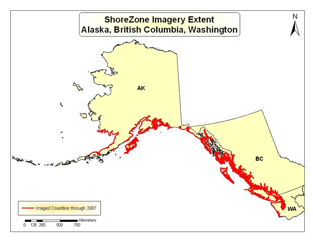
3 What is ShoreZone Coastal Habitat Mapping? Mapping approach that uses georeferenced aerial videography and photography collected at lowest tides of the year with visible light (usually spring and summer) to characterize physical and biological attributes of disscrete intertidal units both along-shore and across-shore, including: wave exposure intertidal flora and fauna geomorphology subtidal algae sediment texture some subtidal fauna Provides a spatial framework for coastal and nearshore habitat assessment on local and regional scales. Enables reasonable interpretations of organism occurrence in coastal and nearshore ecosystems.
4


5 ShoreZone Coastal Habitat Mapping Aerial survey flight path near Prince of Wales Island, SE Alaska Navigation trackline and imagery used to segment the digital shoreline into along-shore units

 attributes")
6 ShoreZone Coastal Habitat Mapping Mapping across-shore physical (geomorphic) attributes and BioBands
7 ShoreZone Coastal Habitat Mapping
8

9 Habitat Capability Modeling Aug07.pdf Photo courtesy Lynn Canal, SE Alaska
10 Habitat Capability Modeling Objective: Appraise the ability of shorelines to support green crab Rationale: Habitat attributes can be distinguished for green crab, rated in terms of importance, and enumerated by the ShoreZone coastal mapping data Assumption: Environmental variables not included in ShoreZone database are within the tolerable range of green crab. These include water temperature, salinity, currents, and biotic factors. Critical habitat attributes for green crab were determined by: Literature review and expert interviews using Delphi methodology Delphi approach to rank most critical factors Attribute queries identify distribution of shorelines capable of supporting colonization Application: Identify priority sites for monitoring and sites with vulnerable resources at risk

11 Are biotic factors in southeast Alaska the same as the west coast of Canada and the U.S.? Red Rock Crab Photo R. Shuman Photo courtesy Lynn Canal, SE Alaska
![Habitat Capability Modeling European Green Crab, Carcinus maenas Critical habitat attributes mapped in ShoreZone Along-shore [Unit]: Protected wave exposure](/docs-images/85/92719204/images/12-0.jpg "Wetlands and estuaries Mudflats and tidal flats Across-shore [XShr]: Fine sediment in lower intertidal Presence of eelgrass (ZOS) Presence of salt marsh")
12 Habitat Capability Modeling European Green Crab, Carcinus maenas Critical habitat attributes mapped in ShoreZone Along-shore [Unit]: Protected wave exposure Wetlands and estuaries Mudflats and tidal flats Across-shore [XShr]: Fine sediment in lower intertidal Presence of eelgrass (ZOS) Presence of salt marsh vegetation (SAL)
13 Habitat Capability Modeling European Green Crab, Carcinus maenas Attribute queries identify distribution of potential habitat on regional scales SEYA SE Alaska Yakutat SEIC SE Alaska Icy Strait SEFJ SE Alaska Fjords W N S E Gulf of Alaska mudflats Mudflats Tidal flats and deltas Mapped shoreline (6,427 km) SE Alaska Shoreline tidal flats BioAreas and deltas = 315 km Kilometers SESI SE Alaska Sitka and Outer Coast
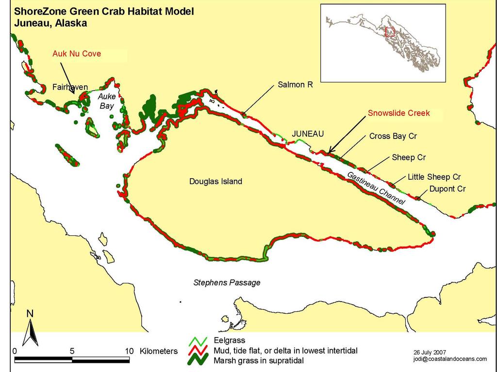
14 Habitat Capability Modeling European Green Crab, Carcinus maenas Lynn LYNN Canal CANAL N W E S St. James St. James Bay Bay State State Marine Park SEFJ SE mudflats Alaska Fjords Bioarea supratidal grasses Mudflats Supratidal grasses Mapped shoreline SE Alaska Shoreline Kilometers Protected wave exposures Mudflats in the lower intertidal Marsh grasses in the supratidal

15 Habitat Capability Modeling European Green Crab, Carcinus maenas St. James Bay Marine Park, Lynn Canal
16
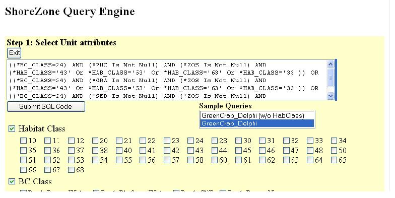
17 QUERY WITH HABITAT CLASS Sand and gravel flat (BC_class 24) + {Eelgrass and Supratidal Marsh Vegetation*} Very protected estuary/wetland (Hab_class 63) + Protected estuary/wetland (Hab_class 53) + Semi-protected estuary/wetland (Hab_class 43) + Semi-exposed estuary/wetland (Hab_class 33) + ((*BC_CLASS=24) AND (*PUC Is Not Null) AND (*ZOS Is Not Null) AND (*HAB_CLASS='43' Or *HAB_CLASS='53' Or *HAB_CLASS='63' Or *HAB_CLASS='33')) OR ((*BC_CLASS=24) AND (*GRA Is Not Null) AND (*ZOS Is Not Null) AND (*HAB_CLASS='43' Or *HAB_CLASS='53' Or *HAB_CLASS='63' Or *HAB_CLASS='33')) OR ((*BC_CLASS=24) AND (*SED Is Not Null) AND (*ZOS Is Not Null) AND (*HAB_CLASS='43' Or *HAB_CLASS='53' Or *HAB_CLASS='63' Or *HAB_CLASS='33')) It can be Hab_Class 33, 43, 53 or 63 or BC_Class 24. Zostera must exist. And at least one of the following has to exists; Sedge, Puccinella or Grass * (Puccinella, Grasses, Sedges)
18 Query Without Habitat Class Eelgrass and Puccinella OR Eelgrass and Grass OR Eelgrass and Sedge ((*PUC Is Not Null) AND (*ZOS Is Not Null)) OR ((*GRA Is Not Null) AND (*ZOS Is Not Null)) OR ((*SED Is Not Null) AND (*ZOS Is Not Null)) Zostera must exist. And at least one of the following has to exists; Sedge, Puccinella or Grass This query gives broader areas.
19

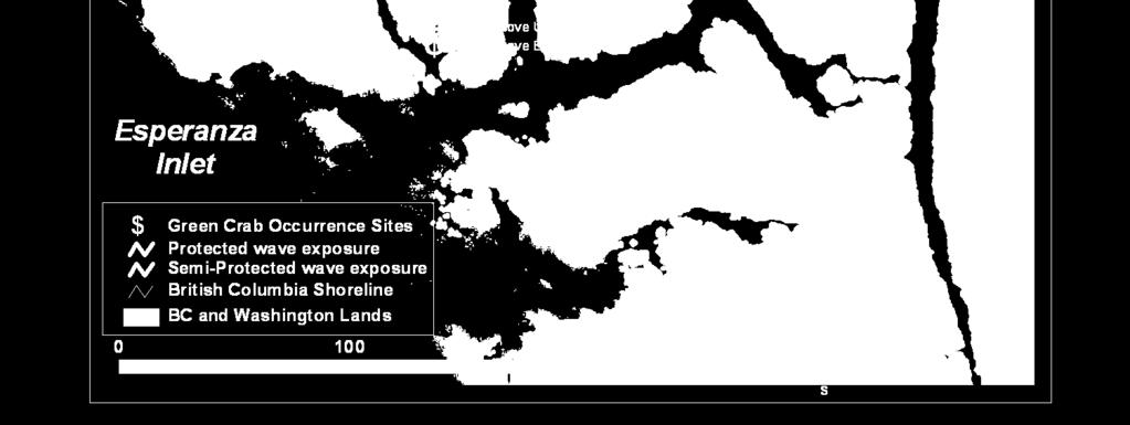
20
21
22
23 Habitat Capability Modeling Regional Applications Alaska British Columbia ShoreZone Pacific Ocean British Columbia 37,000 km of mapped shoreline 5,183 km (16%) contains eelgrass (Zostera) Kilometers Washington Testing models with species occurrence data
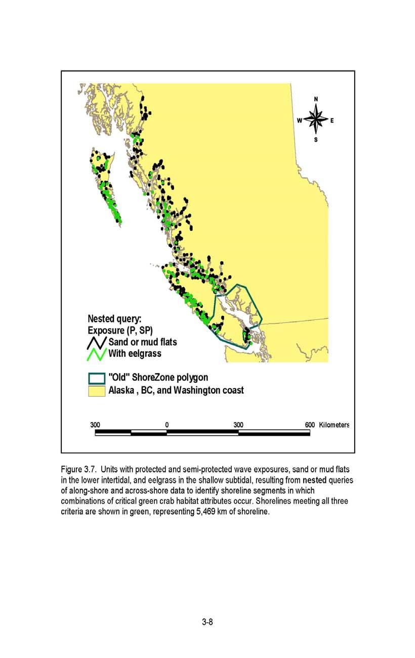
24
 15 with complete")

25 21 sites (Gillespie et al. 2007) 15 with complete ShoreZone data 5 with physical data (no biological)

26 Summary of locations with known green crab occurrence on western Vancouver Island from tables in Gillespie et al. (2007). Of 21 potential sites with ShoreZone data, 15 possessed complete physical and biological ShoreZone attributes and were compared to model predictions with respect to wave exposure, mud and sand flats, eelgrass in the subtidal, and saltmarsh vegetation in the supratidal (indicated by an * in the final column). Five sites ( old data ) possessed mapped physical attributes only (lacking eelgrass and Salicornia information). One site (Esquimalt Harbour) lacked ShoreZone data and was excluded from the analysis.
27 Four Critical Habitat Attributes Protected or Semi-Protected Wave Exposure Sand and mud flat (fine sediment in lower intertidal) Eelgrass in lower intertidal or shallow subtidal Salt marsh vegetation (Salicornia) in supratidal
28

29 Zeballos (Esperanza Inlet) all protected or semi-protected wave exposure 4 critical habitat attributes co-occur
30
 Little Espinosa 3 critical habitat attributes co-occur: - protected/semi-protected - mud or sand flats - Salicornia eelgrass")
31 Espinosa Inlet 2 critical habitat attributes co-occur: - protected/semi-protected - Salicornia flats in Espinosa Inlet are km away (not considered attributes at the sampling site) Little Espinosa 3 critical habitat attributes co-occur: - protected/semi-protected - mud or sand flats - Salicornia eelgrass 500 m away (not considered an attribute at the sampling site)
32 Analysis of BC Data 21 potential sites, 15 of which had complete physical and biological ShoreZone attributes, 5 sites old data, only physical attributes, and were compared to wave exposure and sand and mud flats only. 1 site (Esquimalt Harbor) had no data, excluded.
33 Of the 15 sites with complete data Protected and Semi-Protected wave exposure were mapped at all 15 sites (100%). Sand or mud flats were mapped in 7 of the 15 sites (47%) Eelgrass was mapped in 7 of the 15 sites (47%) The salt marsh grass Salicornia was mapped in the supratidal zone of 10 of the 15 sites (67%) Of the 15 sites, all but one possessed at least two of the four critical habitat attributes (wave exposure and one other attribute) The only site with only one attribute (protected wave exposure; Queen Cove Upper) was within a unit mapped as a gravel flat coastal class. Because gravel flats were not included in the model, this analysis suggests that gravel flats could be included with sand and mud flats in the habitat capability model. Four sites (Cypress Bay, Whitepine Cove, Mooyah Bay and Zeballos) possessed all four attributes in the same location.
34 The exact location of green crab occurrence was difficult to discern in many cases, owing to the resolution of the GPS locations provided (to the minute or to the minute with one decimal place). The along-shore unit in which the site location was plotted was the only one for which habitat attributes were considered at the site. That is, in some cases eelgrass and Salicornia may have been present in a unit ( average 250m) within 500m of the plotted location, but were not considered present at the sampling site. Shorezone can miss features less than 10 meters ( such as intertidal eelgrass pools). Shorezone finds subtidal features better, intertidal features better seen by field verification on the ground. Some habitat features could have been missed in this analysis.
 contains salt marsh vegetation (sedges, Salicornia, Triglochlin) Testing models with species occurrence data")
35 Habitat Capability Modeling Regional Applications Washington State ShoreZone 4,936 km of mapped shoreline 1,536 km (31%) contains salt marsh vegetation (sedges, Salicornia, Triglochlin) Testing models with species occurrence data
36 Thank You! Partners: Alaska State DNR, DF&G Archipelago Marine Research Ltd Coastal and Ocean Resources Inc Cook Inlet Regional Citizens Advisory Council Exxon Valdez Oil Spill Trustee Council Kenai Peninsula Borough National Park Service NOAA National Marine Fisheries Service North Pacific Research Board Prince William Sound Regional Citizens Advisory Council Prince William Sound Science Center Province of British Columbia The Nature Conservancy U.S. Fish & Wildlife Service Washington State DNR South Prince of Wales Island, Misty Fjords National Monument
Coastal Habitat Mapping Program. Bristol Bay & Southwest Alaska Data Summary Report September 2012
 Coastal Habitat Mapping Program Bristol Bay & Southwest Alaska Data Summary Report September 2012 Prepared for: NOAA National Marine Fisheries Service Alaska Region On the Cover: Cape Lapin Kenmore Head
Create your own map for tidepooling, beach field trips, boating, camping, kayaking, fishing, and exploring the beaches in Southcentral Alaska.
 Create your own map for tidepooling, beach field trips, boating, camping, kayaking, fishing, and exploring the beaches in Southcentral Alaska. Here s an opportunity to download and customize your own free
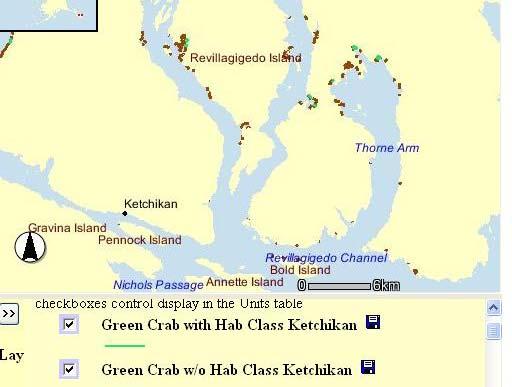
ShoreZone Coastal Habitat Mapping Interim Data Summary Report. Ketchikan Area, Revillagigedo Island Southeast Alaska
 CORI Project: 2006-19 December 2007 ShoreZone Coastal Habitat Mapping Interim Data Summary Report Ketchikan Area, Revillagigedo Island Southeast Alaska Alaska Revillagigedo Island Ketchikan # Prepared
Alaska ShoreZone Coastal Habitat Mapping Program
 Alaska ShoreZone Coastal Habitat Mapping Program Auke Bay Laboratories Alaska Fisheries Science Center Mandy Lindeberg Coastal Issues in Alaska Resource development Coastal development Climate change Loss
ssessments Ecoregional Assessment
 Standard 7: Select terrestrial, freshwater and marine conservation targets/biodiversity elements/features across multiple biological and spatial scales. Case Study: Shoreline Habitat Classification for
Relatively little hard substrate occurs naturally in the
 CHAPTER FIVE Rock Habitats Relatively little hard substrate occurs naturally in the estuary, owing mainly to the vast quantities of fine sediment that have been deposited by the rivers. Rock habitat is
Subtidal permanently flooded with tidal water. Irregularly exposed surface exposed by tides less often than daily
 Types of Wetlands Tidal Systems COASTAL WETLAND ECOSYSTEMS Tidal Salt Marshes Tidal Freshwater Marshes Mangrove Wetlands Tidal Estuarine Wetland 1 Definition and Formation of Estuaries u Estuary : partially
The Problem. Which ecosystems are the most sensitive? Where will ecosystems be migrating? Where will investments be overwhelmed?
 BC Parks BC Parks is responsible for the designation, management and conservation of a system of ecological reserves, provincial parks and recreation areas located throughout the province. British Columbia
Types of Wetlands. Tidal Systems
 Types of Wetlands Tidal Systems 1 COASTAL WETLAND ECOSYSTEMS Tidal Salt Marshes Tidal Freshwater Marshes Mangrove Wetlands 2 Tidal Estuarine Wetland 3 Definition and Formation of Estuaries Estuary: : partially
Integrating new coastline information and geographically coordinated coastal geomorphology data
 Integrating new coastline information and geographically coordinated coastal geomorphology data NOAA Contemporary Shoreline DOE Coastal Geomorphology Cynthia Miller Corbett Jeff Simley 1 National Hydrography
Sea Level Rise Providing Nature A-Right-of Way
 Sea Level Rise Providing Nature A-Right-of Way Study Area Site 2: Skagit Bay Initial Condition 11.2 Inches by 2050 No Dikes 27.3 Inches by 2100 No Dikes The Problem Loss of coastal wetlands due to submergence
Coastal and Marine Ecological Classification Standard (CMECS)
") Coastal and Marine Ecological Classification Standard (CMECS) Kathy Goodin, NatureServe EMECS, August 2011 Baltimore, MD 1 Outline Objectives & Process Classification Content Questions 2 Objectives Develop
Coastal and Marine Ecological Classification Standard (CMECS) Kathy Goodin, NatureServe EMECS, August 2011 Baltimore, MD 1 Outline Objectives & Process Classification Content Questions 2 Objectives Develop
Significant Ecological Marine Area Assessment Sheet
 Significant Ecological arine Area Assessment Sheet Name: Eastern Bay of Island Biogenic Soft Sediment Complex Summary: The semi-sheltered areas between the central islands of the Eastern Bay of Islands
Cowichan Estuary Habitat Mapping and Oyster Population Assessment. Cowichan Stewardship Round Table
 Cowichan Estuary Habitat Mapping and Oyster Population Assessment Presentation at Cowichan Stewardship Round Table June 21, 2018 By Dr. Goetz Schuerholz 1 More than 8000 drone photos taken stitched together
Bob Van Dolah. Marine Resources Research Institute South Carolina Department of Natural Resources
 Bob Van Dolah Marine Resources Research Institute South Carolina Department of Natural Resources Shoreline Change Will Occur! On our front beaches where it is not easy to retreat Shoreline Change Will
Aim and objectives Components of vulnerability National Coastal Vulnerability Assessment 2
 ASSESSING THE UTILITY OF GEOMORPHIC SENSITIVITY MAPPING ON THE ILLAWARRA COAST Pamela Abuodha, Christina Baker, Chris Sharples, Darren Skene and Colin Woodroffe Geoquest Research Centre, University of
Sea-level Rise on Cape Cod: How Vulnerable Are We? Rob Thieler U.S. Geological Survey Woods Hole, MA
 Sea-level Rise on Cape Cod: How Vulnerable Are We? Rob Thieler U.S. Geological Survey Woods Hole, MA Outline Sea-level and coastal processes Past sea-level change Predictions for the future Coastal responses
The Systems Approach. Alun Williams, ABPmer
 The Systems Approach Alun Williams, ABPmer Overview What is A Systems Approach? Behavioural / Qualitative Modelling? System Definition / Mapping (Behavioural Statements Objective) What is a Systems Approach?
Puget Sound Shorelines. Announcements
 Announcements Puget Sound Shorelines Wednesday discussion of Bates paper Bham Bay project: Updates, finals week schedules Last portion of the class: Environmental issues in Puget Sound Puget Sound shorelines:
Sediment Management in the Coastal Bays
 Sediment Management in the Coastal Bays Introduction Need for ecosystem view of sediment management in Coastal Bays Island loss and restoration Navigation needs Habitat Trade offs Living Shoreline Requirements
3 SHORELINE CLASSIFICATION METHODOLOGY
 3 SHORELINE CLASSIFICATION METHODOLOGY Introduction The ESI scale, as described in Section 2, categorizes coastal habitats in terms of their susceptibility to spilled oil, taking into consideration a number
Coastal and Marine Ecological Classification Standard (CMECS)
") Coastal and Marine Ecological Classification Standard (CMECS) Mark Finkbeiner NOAA Coastal Services Center Presented at the International Workshop on Seabed Mapping Methods and Technology 18 October 2012
Coastal and Marine Ecological Classification Standard (CMECS) Mark Finkbeiner NOAA Coastal Services Center Presented at the International Workshop on Seabed Mapping Methods and Technology 18 October 2012
Spatial variation in the abundance of eelgrass (Zostera marina) at eight sites in western Newfoundland, Canada 5/5/2015 V2.0
 at eight sites in western Newfoundland, Canada 5/5/2015 V2.0") Spatial variation in the abundance of eelgrass (Zostera marina) at eight sites in western Newfoundland, Canada 5/5/2015 V2.0 1 Summary The abundance of eelgrass (Zostera marina) was quantified at eight
Spatial variation in the abundance of eelgrass (Zostera marina) at eight sites in western Newfoundland, Canada 5/5/2015 V2.0 1 Summary The abundance of eelgrass (Zostera marina) was quantified at eight
Management of Spartina anglica in the Fraser River estuary, British Columbia
 Management of Spartina anglica in the Fraser River estuary, British Columbia Gary Williams GL Williams & Associates Ltd. White Rock & Surrey Naturalists Society May 12 th, 2005 White Rock, BC Presentation
PROBABILITY-BASED ESTIMATION OF NEARSHORE HABITAT CHARACTERISTICS
 In: Proceedings of Puget Research '98 Conference, Seattle, WA. PROBABILITY-BASED ESTIMATION OF NEARSHORE HABITAT CHARACTERISTICS Allison Bailey, Helen Berry, Betty Bookheim Washington State Department
Habitat Mapping in The Hauraki Gulf Marine Park. Dan Breen
 Habitat Mapping in The Hauraki Gulf Marine Park Dan Breen Outline 1. Intro Habitat mapping 2. Coastal marine habitats and marine protected areas in the New Zealand Territorial Sea: a broad scale gap analysis
CHAPTER 28. PHYSIOGRAPHY Cook Inlet Drainages
 PEBBLE PROJECT ENVIRONMENTAL BASELINE DOCUMENT 2004 through 2008 CHAPTER 28. PHYSIOGRAPHY Cook Inlet Drainages PREPARED BY: Knight Piésold Ltd. PHYSIOGRAPHY COOK INLET DRAINAGES TABLE OF CONTENTS TABLE
1 Shoreline Landforms 2. 2 Emergent v. Submergent 2. 3 Wavecutting 3. 4 Planview 4. 5 Marine Terraces 5. 6 California 7. 7 Tombolos, Sea Stacks 8
 Shorelines November 9, 2008 Contents 1 Shoreline Landforms 2 2 Emergent v. Submergent 2 3 Wavecutting 3 4 Planview 4 5 Marine Terraces 5 6 California 7 7 Tombolos, Sea Stacks 8 8 Active Processes 9 9 Emergence
Community Mapping Network. Selected Coastal Atlases and Information Systems in British Columbia, Canada
 Community Mapping Network Selected Coastal Atlases and Information Systems in British Columbia, Canada Outline Community Mapping Network cmnbc.ca Pacific Coastal Resources Atlas for BC cmnbc.ca The Living
Development of an International Arctic Observations Assessment Framework
 Development of an International Arctic Observations Assessment Framework Dr. Steven Lev, Dr. Jason Gallo Briefing for the Sustaining Arctic Observing Networks (SAON) April 7, 2017 International Partners
3.0 ROBERTS BANK TIDAL FLAT MORPHOLOGY
 Vancouver Port Authority Northwest Hydraulic Consultants Ltd. /Triton Consultants Ltd. Roberts Bank Container Expansion File: 33863 Coastal Geomorphology Study - 19 - November 2004 3.0 ROBERTS BANK TIDAL
Regional-scale understanding of the geologic character and sand resources of the Atlantic inner continental shelf, Maine to Virginia
 Regional-scale understanding of the geologic character and sand resources of the Atlantic inner continental shelf, Maine to Virginia Workshop on Dredging, Beach Nourishment and Bird Conservation Atlantic
Marine Geomorphology as a Determinant for Essential Life Habitat III
 Marine Geomorphology as a Determinant for Essential Life Habitat III marinecoastalgis.net/aag08 10:10 Dawn Wright, Oregon 10:30 Will McClintock, California 10:50 Daniel Sampson, Massachusetts 11:10 Gary
Biogeographic Approach to Coastal Assessments & Spatial Planning
 NOAA s Biogeographic Approach to Coastal Assessments & Spatial Planning Mark E. Monaco Mark.Monaco@noaa.gov Center for Coastal Monitoring and Assessment http://ccma.nos.noaa.gov/about/biogeography Biogeography
Quantifying effects of oil on coastal dune vegetation. Thomas Miller and Elise Gornish Biological Science, Florida State University
 Quantifying effects of oil on coastal dune vegetation Thomas Miller and Elise Gornish Biological Science, Florida State University Natural History of Barrier Islands in the Northern Gulf Make up ~70% of
2.2.7 Backbarrier flats
 FIGURE 24. VERTICAL PHOTOGRAPH SHOWING THE DEVELOPMENT OF SMALL PARABOLIC DUNES FROM BLOWOUTS IN A LARGE RELICT FOREDUNE NORTHWEST OF HUNTER'S CREEK. PHOTOGRAPH COURTESY OF CAR'T'ER HOLT HARVEY FORESTS
South Carolina Coastal Habitats
 South Carolina Coastal Habitats By C. Livingston, 2009 Earth Where is South Carolina? North America United States of America SC Here we are! South Carolina borders the Atlantic Ocean. Did you know? South
APPENDIX D. BUILDING THE TRAVEL COST MODEL
 APPENDIX D. BUILDING THE TRAVEL COST MODEL APPENDIX D. BUILDING THE TRAVEL COST MODEL As discussed in Appendix C, we estimated cost, site choice, and participation equations from the survey data. We used
Integrating ARCGIS with Datamining Software to Predict Habitat for Red Sea Urchins on the Coast of British Columbia.
 Integrating ARCGIS with Datamining Software to Predict Habitat for Red Sea Urchins on the Coast of British Columbia. Wayne Hajas Pacific Biological Station Nanaimo, BC 1 Allison Smeaton GIS-student intern
%ULWLVK&ROXPELD(VWXDU\0DSSLQJ 6\VWHP
 %ULWLVK&ROXPELD(VWXDU\0DSSLQJ 6\VWHP Prepared by Land Use Coordination Office for the Coastal Task Force, Resource Inventory Committee Resources Inventory Committee Version 1.0 March 1999 The Province
Presentation Outline. Project Overview. Sea Level Rise Assessment & Decision Tools. Community Engagement. Tina Whitman, Friends of the San Juans
 Healthy Beaches for People & Fish Sea Level Rise Adaptation Tools for San Juan County, WA Tina Whitman & Andrea MacLennan December 10, 2015 Presentation Outline Project Overview Tina Whitman, Friends of
Home About Us Articles Press Releases Image Gallery Contact Us Media Kit Free Subscription 10/5/2006 5:56:35 PM
 Home About Us Articles Press Releases Image Gallery Contact Us Media Kit Free Subscription 10/5/2006 5:56:35 PM Industry Resources Industry Directory NASA Links Missions/Launches Calendar Human development
TASMANIAN SEAGRASS COMMUNITIES
 TASMANIAN SEAGRASS COMMUNITIES by Christopher Grant Rees, B.Ed (}Ions.) Submitted in partial fulfilment of the requirement for the degree of Master of Environmental Studies (By Coursework) Centre for Environmental
The Use of Geographic Information Systems to Assess Change in Salt Marsh Ecosystems Under Rising Sea Level Scenarios.
 The Use of Geographic Information Systems to Assess Change in Salt Marsh Ecosystems Under Rising Sea Level Scenarios Robert Hancock The ecological challenges presented by global climate change are vast,
Primer on Coastal Erosion And Habitat Creation
 2 nd Regional Conference Dredging, Beach Nourishment & Bird Conservation Primer on Coastal Erosion And Habitat Creation Timothy Kana Ph.D Source: Newsday 1962 Photo by Kelsey Aerials 1978 Source: U Mass
Microplastics in the marine environment of coastal British Columbia
 Microplastics in the marine environment of coastal British Columbia Jean-Pierre Desforges 1, Moira Galbraith 2, Neil Dangerfield 2, Peter Ross 1 1 School of Earth and Ocean Sciences, University of Victoria,
Design of Levee Breaches in Sheltered Water for Flood Risk Reduction & Marsh Restoration ASFMP; June 5, 2014 Presented By:
 Design of Levee Breaches in Sheltered Water for Flood Risk Reduction & Marsh Restoration ASFMP; June 5, 2014 Presented By: Rohin Saleh Alameda County Flood Control District Matt Powers, P.E. GEI Consultants
The Coast: Beaches and Shoreline Processes
 1 2 3 4 5 6 7 8 9 The Coast: es and Shoreline Processes Trujillo & Thurman, Chapter 10 Oceanography 101 Chapter Objectives Recognize the various landforms characteristic of beaches and coastal regions.
Question: What is the primary reason for the great abundance of fish along the Peruvian coast?
 Buzzer Question # 1 Question Type: toss-up Question Format: Multiple Choice Category: Biology What is the primary reason for the great abundance of fish along the Peruvian coast? Answer W: upwelling Answer
The Coast: Beaches and Shoreline Processes Trujillo & Thurman, Chapter 10
 The Coast: es and Shoreline Processes Trujillo & Thurman, Chapter 10 Oceanography 101 Chapter Objectives Recognize the various landforms characteristic of beaches and coastal regions. Identify seasonal
Aundrea McBride, Karen Wolf, and Eric Beamer June 2006
 SKAGIT BAY NEARSHORE HABITAT MAPPING Aundrea McBride, Karen Wolf, and Eric Beamer June 2006 INTRODUCTION Juvenile Chinook salmon travel through and utilize nearshore habitats as part of their life cycle.
Modeling the Transport and Fate of Sediments Released from Dredging Projects in the Coastal Waters of British Columbia, Canada
 WEDA Dredging Summit & Expo 18 Modeling the Transport and Fate of Sediments Released from Dredging Projects in the Coastal Waters of British Columbia, Canada David B. Fissel, Yuehua (Andy) Lin and Todd
Exxon Valdez Oil Spill Restoration Project Annual Report
 Exxon Valdez Oil Spill Restoration Project Annual Report Ecology and Demographics of Pacific Sand Lance, Ammodytes hexapterus Pallas, in Lower Cook Inlet, Alaska Restoration Project 99306 Final Report
Subduction Zone Observatory
 Subduction Zone Observatory Observations made with simple tools can provide important scientific constraints. (can also combine with more sophisticated measurements). Standardized well-planned marine intertidal
Extent and Degree of Shoreline Oiling: Deepwater Horizon (DWH) Oil Spill, Scott Zengel Research Planning, Inc. Tallahassee, Florida
 Oil Spill, Scott Zengel Research Planning, Inc. Tallahassee, Florida") Extent and Degree of Shoreline Oiling: Deepwater Horizon (DWH) Oil Spill, 2010 2013 Scott Zengel Research Planning, Inc. Tallahassee, Florida Background & Definitions SCAT survey data presented here SCAT
Extent and Degree of Shoreline Oiling: Deepwater Horizon (DWH) Oil Spill, 2010 2013 Scott Zengel Research Planning, Inc. Tallahassee, Florida Background & Definitions SCAT survey data presented here SCAT
Adaptation to Sea Level Rise A Regional Approach
 Adaptation to Sea Level Rise A Regional Approach Project Partners: in Saco Bay, ME Peter Slovinsky, Marine Geologist Maine Geological Survey, Department of Conservation Project Funding from: Saco Bay Hazards
STAMP Spa)al Tools for Arc)c Mapping & Planning. Creating an interactive data tool to improve access and usability of Arctic data
al Tools for Arc)c Mapping & Planning. Creating an interactive data tool to improve access and usability of Arctic data") STAMP Spa)al Tools for Arc)c Mapping & Planning Creating an interactive data tool to improve access and usability of Arctic data Mission Provide easy access to physical, chemical, and biological data Network
STAMP Spa)al Tools for Arc)c Mapping & Planning Creating an interactive data tool to improve access and usability of Arctic data Mission Provide easy access to physical, chemical, and biological data Network
Shoreline Assessment Job Aid National Oceanic and Atmospheric Administration NOAA Ocean Service Office of Response and Restoration Hazardous
 Shoreline Assessment Job Aid National Oceanic and Atmospheric Administration NOAA Ocean Service Office of Response and Restoration Hazardous Materials Response Division This job aid was produced and published
Projects Funded in 2012
 Arctic Landscape Conservation Cooperative Advancing Science, Understanding Change. Projects Funded in 2012 The Big Picture In 2012, the Arctic LCC funded wholly, or in part, 16 projects and study planning
Australian Coastal Councils Conference
 Australian Coastal Councils Conference 11 March 2015 Estimating Future Coastal Inundation and Erosion Hazards Dr Andrew McCowan Dr Christine Lauchlan-Arrowsmith Warwick Bishop Background Victorian Future
Whiskey Island Marsh Creation Rolling with the Punches
 Whiskey Island Marsh Creation Rolling with the Punches Santiago Alfageme, M&N Jerry Carroll, LADNR Brad Miller, LADNR Project Location Historic Island Retreat Previous Restoration Project Whiskey Island
July Submitted to Point No Point Treaty Council. Submitted by
 Assessment of Estuarine and Nearshore Habitats for Threatened Salmon Stocks in the Hood Canal and Eastern Strait of Juan de Fuca, Washington State: Focal Areas 1-4 July 2002 Submitted to Point No Point
Some Thoughts on the Role of Elevation
 Some Thoughts on the Role of Elevation Data in Sea-level Rise Impact Assessments Rob Thieler* U.S. Geological Survey Coastal and Marine Geology Program Woods Hole, MA *i l d t i l d f D C h D G h *includes
Marine Biodiversity: Global Ocean to the Salish Sea Design Your Own Salish Sea Creature
 Science Unit: Lesson #2 Marine Biodiversity: Global Ocean to the Salish Sea Design Your Own Salish Sea Creature Summary: Lesson type: Grade level: Duration of lesson: Developed by: Developed for: Based
Appendix 10: Non-Potential of Natural Gas Hydrate Occurrence in Queen Charlotte Basin8
 British Columbia Offshore Hydrocarbon Development Appendix 10: Non-Potential of Natural Gas Hydrate Occurrence in Queen Charlotte Basin8 Natural gases such as methane, ethane, propane typically occur as
Shoreline and Climate Change Adaptation Alternatives for The Letter Parcel, Bolinas Lagoon
 Shoreline and Climate Change Adaptation Alternatives for The Letter Parcel, Bolinas Lagoon Scenic shoreline vista of Bolinas Lagoon and ridges, from Letter Parcel, March 2016 Peter Baye, Coastal Ecologist
ESTUARINE CONDITIONS AND WATER EXCHANGE IN FJORDS OF PRINCE WILLIAM SOUND, ALASKA. A Dissertation by Shelton M. Gay III Texas A&M University
 ESTUARINE CONDITIONS AND WATER EXCHANGE IN FJORDS OF PRINCE WILLIAM SOUND, ALASKA A Dissertation by Shelton M. Gay III Texas A&M University Coastal Relief (DEM) of PWS Valdez > 800m Naked Island Montague
Sri Lanka has a coastline of km excluding the shoreline of bays and inlets.
 Defining and Demarcating Coastal zones in Sri Lanka Procedure, Challenges and What needs to be done? Dr. Anil Premaratne Director General Coast Conservation Coast Conservation Department Sri Lanka 1 Sri
Columbia Estuary Province
 Rolling Provincial Review: Implementation 2001-2004 Province 73 Columbia Basin Fish & Wildlife Authority Province FY 2001-2004 Spending Summaries NPCC Recommendations and BPA Spending by Project Category,
High Resolution Numerical Models of Tidal Marshes in the Delaware Bay
 High Resolution Numerical Models of Tidal Marshes in the Delaware Bay Ramona Stammermann Dept. of Civil, Architectural & Environmental Engineering, Drexel University, Philadelphia, PA Michael Piasecki
What is a landform? These shapes (except for bodies of water) on the earth s surface are all examples of landforms.
 on the earth s surface are all examples of landforms.") Landforms What is a landform? These shapes (except for bodies of water) on the earth s surface are all examples of landforms. archipelago a large group of many islands. The Hawaiian Islands Lighthouse
Landforms What is a landform? These shapes (except for bodies of water) on the earth s surface are all examples of landforms. archipelago a large group of many islands. The Hawaiian Islands Lighthouse
ALASKA OCEAN OBSERVING SYSTEM 2016 ANNUAL IMPACT REPORT
 ALASKA OCEAN OBSERVING SYSTEM 2016 ANNUAL IMPACT REPORT 1 ALASKA OCEAN OBSERVING SYSTEM 2016 ANNUAL IMPACT REPORT 2 ALASKA OCEAN OBSERVING SYSTEM 2016 ANNUAL IMPACT REPORT Letter from Executive Director
UNIT 2 WARM UP. List the OCEANS. Bonus: Name the Largest LAKE on Earth
 UNIT 2 WARM UP List the OCEANS Bonus: Name the Largest LAKE on Earth Land Forms Land Mountain Hill Cliff Butte Mesa Plateau Cave Volcano Desert Plains Prairie Steppe Marsh Swamp Tundra Glacier Continent
Annual transport rates at two locations on the fore-slope.
 Sediment Transport by Currents Fore-slope Sediment transport rates and sediment concentrations were computed from the hydrodynamic model runs as well as from direct measurements of current velocities at
Introduction: The Gulf of Mexico Alliance. The Gulf GAME project MERMAid and PHINS Results & Conclusions What s next? Examples
 AAG Las Vegas March 25, 2009 Introduction: Ocean governance and Ecosystem-Based Management The Gulf of Mexico Alliance Habitat Identification and Characterization The Gulf GAME project MERMAid and PHINS
Quantifying Coastal Evolution using Remote Sensing Approaches
 Quantifying Coastal Evolution using Remote Sensing Approaches Sojan Mathew, Linh Truong Hong, Xavier Pellicer*, Colman Gallagher University College Dublin Geological Survey of Ireland* INFOMAR SEMINAR,
TSUNAMI and SEICHE DEFINITIONS:
 TSUNAMI and SEICHE DEFINITIONS: Seiche The action of a series of standing waves (sloshing action) of an enclosed body or partially enclosed body of water caused by earthquake shaking. Seiche action can
B.C. s Offshore Oil and Gas: a Guide to the Geology and Resources.
 B.C. s Offshore Oil and Gas: a Guide to the Geology and Resources. Introduction Beneath the offshore regions of British Columbia are four moderately large, geologically young sedimentary basins (Figure
Marine biodiversity - PBBT102
 Marine biodiversity - PBBT102 UNIT 1 (2 marks) 1. Define marine biodiversity? 2. How biodiversity is measured? 3. Why many species go extinct every day? 4. What is biodiversity hotspot? 5. What are endemic
APPENDIX E-4. Field Report: Intertidal Habitat and Marine Biota Survey
 APPENDIX E-4 Field Report: Intertidal Habitat and Marine Biota Survey Field Report Intertidal Habitat and Marine Biota Survey of the Vallejo Marine Terminal Site, Vallejo, California April 18, 2014 Prepared
Annual algae communities on Baltic infralittoral coarse sediment
 European Red List of Habitats Marine: Baltic Sea Habitat Group Annual algae communities on Baltic infralittoral coarse sediment Summary This habitat is found in all the Baltic Sea subbasins and is especially
What is a landform? These shapes (except for bodies of water) on the earth s surface are all examples of landforms.
 on the earth s surface are all examples of landforms.") Landforms What is a landform? These shapes (except for bodies of water) on the earth s surface are all examples of landforms. archipelago a large group of many islands. The Hawaiian Islands Lighthouse
Landforms What is a landform? These shapes (except for bodies of water) on the earth s surface are all examples of landforms. archipelago a large group of many islands. The Hawaiian Islands Lighthouse
Unit 1 Physical Setting
 Unit 1 Physical Setting Chapter 1: Finding Your Way Chapter 2: Our Natural Environment Chapter 3: The Changing Weather Chapter 4: A Place To Live Chapter 1: Finding Our Way Key Terms Lines of Latitude
Biomes of the World What is a Biome?
 Biomes of the World What is a Biome? A large, relatively distinct terrestrial region with characteristic Climate Soil Plants Animals Interacting landscapes 1 Terrestrial Biomes Using Precipitation And
Exxon Valdez Oil Spill Gulf Ecosystem Monitoring and Research Project Final Report. Mapping Marine Habitat - Kodiak Island
 Exxon Valdez Oil Spill Gulf Ecosystem Monitoring and Research Project Final Report Mapping Marine Habitat - Kodiak Island GEM Project 020619 Final Report Robert J. Foy Fishery Industrial Technology Center
Active Coastal Processes in the Lubec Embayment
 The Lubec Embayment Maine Geologic Facts and Localities August, 1998 Active Coastal Processes in the Lubec Embayment 44 49 50.51 N, 66 59 34.16 W Text by Joseph T. Kelley, Department of Agriculture, Conservation
Restored oyster reefs enhance estuarine ecosystem services by altering nearshore salinity
 Restored oyster reefs enhance estuarine ecosystem services by altering nearshore salinity Photo: UF/IFAS David Kaplan, Maitane Olabarrieta, Peter Frederick, and Arnoldo Valle-Levinson Globally: Most Threatened
A Geographic Information System Based Model John L Marshall Geography 562 GIS Coastal Resources - Final Project: Fall 2017 University of Washington
 EFFECTS OF OYSTER CULTURE ON NATIVE EELGRASS AND RELATED NATURAL RESOURCES IN THE PUGET SOUND A Geographic Information System Based Model John L Marshall Geography 562 GIS Coastal Resources - Final Project:
Hurricane Katrina and Oil Spills: Impact on Coastal and Ocean Environments
 Archived version from NCDOCKS Institutional Repository http://libres.uncg.edu/ir/asu/ Pine, J. C. (June 2006). Hurricane Katrina and oil spills: Impact on coastal and ocean environments. Oceanography,
Baseline Estuarine-Upland Transition Zone
 Baseline Estuarine-Upland Transition Zone in SF, San Pablo and Suisun Bays 10/5/18 Prepared for San Francisco Bay Joint Venture (SFBJV) Prepared by Brian Fulfrost, Principal bfaconsult@gmail.com with additional
Use of Bioengineering Techniques for Revegetation of Riparian Areas: Colomac Mine Remediation Project, NWT
 Use of Bioengineering Techniques for Revegetation of Riparian Areas: Colomac Mine Remediation Project, NWT McPherson, M. 1, Vanderspiegel, R. 2, Breadmore, R. 2, and Hewitt, M. 3 2012 RPIC Federal Contaminated
Magnitude 7.0 N of ANCHORAGE, ALASKA
 A magnitude 7.0 earthquake occurred just before 8:30 am local time 8 miles north of Anchorage at a depth of 40.9 km (25.4 miles). There are reports of major infrastructure damage and damage to many homes
Coastal Impacts of Climate Change in the Northwest: A Summary of the Findings of the upcoming National Climate Assessment
 Western Washington University Western CEDAR Salish Sea Ecosystem Conference 2014 Salish Sea Ecosystem Conference (Seattle, Wash.) May 1st, 3:30 PM - 5:00 PM Coastal Impacts of Climate Change in the Northwest:
Poole Harbour. Saltmarsh Monitoring 2006
 Poole Harbour Saltmarsh Monitoring 2006 Jon Corkhill & Bryan Edwards Library Headquarters Colliton Park Dorchester Dorset DT1 1XJ AN OVERVIEW OF SPARTINA MARSHES IN POOLE HARBOUR Spartina anglica is the
Marine habitat map of Northland: Mangawhai to Ahipara
 Marine habitat map of Northland: Mangawhai to Ahipara Version 1 April 2009 Vince Kerr Published by Department of Conservation P.O. Box 842 Whangarei 0140, New Zealand This report was prepared by Vince
SIF_7.1_v2. Indicator. Measurement. What should the measurement tell us?
 Indicator 7 Area of natural and semi-natural habitat Measurement 7.1 Area of natural and semi-natural habitat What should the measurement tell us? Natural habitats are considered the land and water areas
CORRELATION ANALYSIS BETWEEN PALAEMONETES SHRIMP AND VARIOUS ALGAL SPECIES IN ROCKY TIDE POOLS IN NEW ENGLAND
 CORRELATION ANALYSIS BETWEEN PALAEMONETES SHRIMP AND VARIOUS ALGAL SPECIES IN ROCKY TIDE POOLS IN NEW ENGLAND Douglas F., Department of Biology,, Worcester, MA 01610 USA (D@clarku.edu) Abstract Palamonetes
Supplemental Slides. Shore: Junction of Land & Water. Junction of Land & Water. Sea Level Variations. Shore vs. Coast. Sea Level Variations
 Shore: Junction of Land & Water Supplemental Slides Sediments come off land Most get dumped at the beach Sediment interacts with ocean waves and currents Junction of Land & Water Features: Breaking waves,
Shore: Junction of Land & Water. Sediments come off land Most get dumped at the beach Sediment interacts with ocean waves and currents
 Shore: Junction of Land & Water Supplemental Slides Sediments come off land Most get dumped at the beach Sediment interacts with ocean waves and currents Junction of Land & Water Features: Breaking waves,
Joint Federal Agency Submerged Aquatic Vegetation Survey Guidance for the New England Region Updated August 11, 2016
 Joint Federal Agency Submerged Aquatic Vegetation Survey Guidance for the New England Region Updated August 11, 2016 FOREWORD This guidance is the result of on-going interagency collaboration between the