Alaska ShoreZone Coastal Habitat Mapping Program
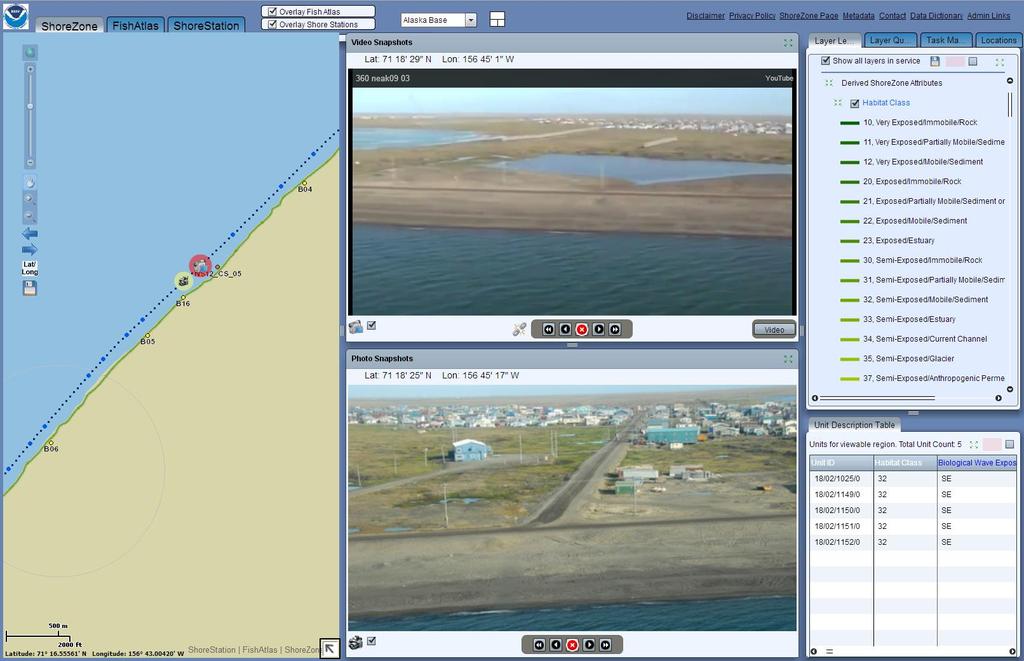
|
|
|
- Myles O’Brien’
- 5 years ago
- Views:
Transcription


1 Alaska ShoreZone Coastal Habitat Mapping Program Auke Bay Laboratories Alaska Fisheries Science Center Mandy Lindeberg

2 Coastal Issues in Alaska Resource development Coastal development Climate change Loss of sea Ice Coastal erosion Increased vessel traffic Subsistence needs


3 History of Human Impacts to Alaska s Coast Exxon Valdez oil spill 1989 Selendang Ayu break up 2004 Drill Rig Kulluk 2013 Canadian barge Oct. 2014? 134 ft. barge adrift, Beaufort Sea

4 What is ShoreZone? A standardized coastal habitat mapping product: ShoreZone images and characterizes biophysical attributes of discrete shore units in both along-shore and across-shore components in a searchable, spatially explicit database. wave exposure geomorphology sediment texture biota man-made features features

5 Alaska ShoreZone Program: A partnership of many agencies and NGOs collaborating on various phases of ShoreZone: Phase I Acquiring Coastal Imagery Phase II Habitat Mapping Phase III Online Products, outreach

6 Phase I: Aquiring Coastal Imagery Planning, Logistics, etc. Consultations, awareness in coastal communities Land ownership and permitting Flight plan, fueling locations, lodging, food I thought you ordered the fuel?


7 Phase I: Acquiring Coastal Imagery Mapping is based on video and still imagery: low altitude oblique geo-referenced low tide


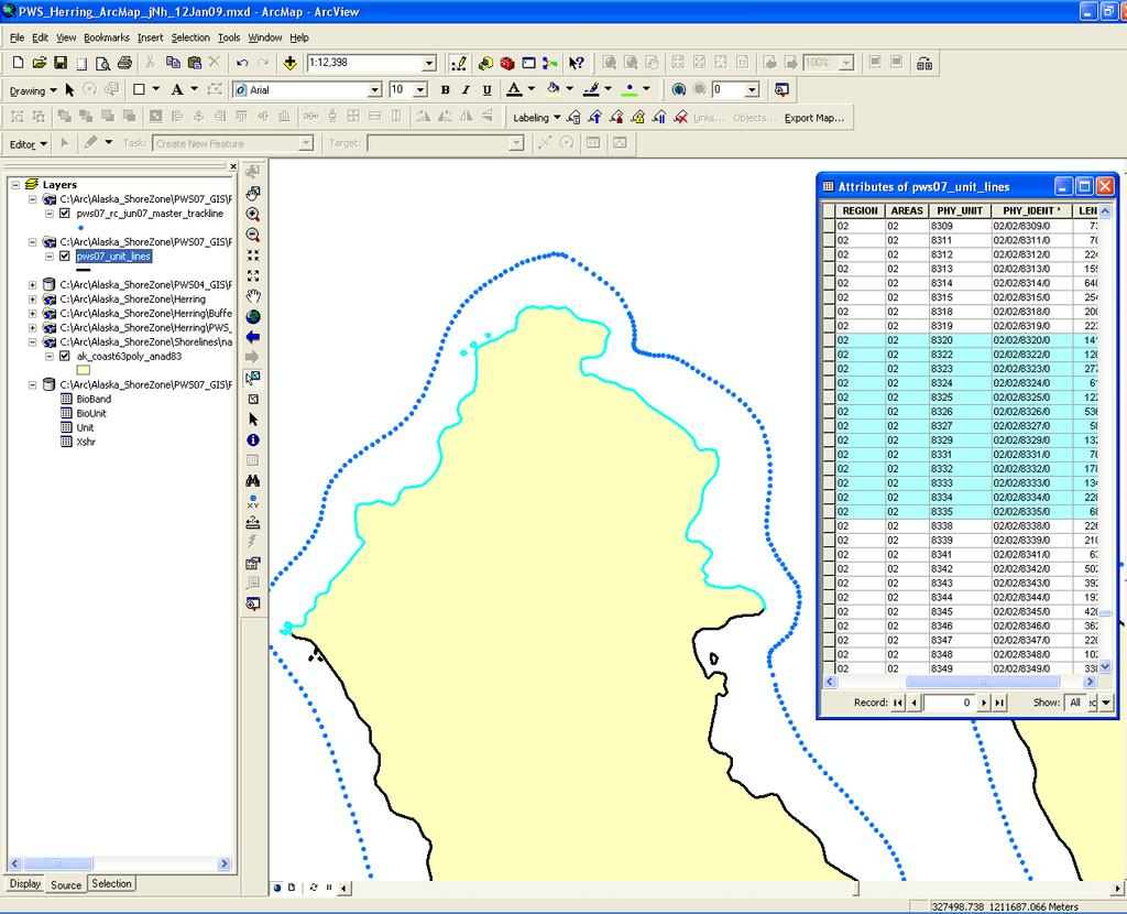
8 Phase II: Habitat Mapping - Digital Shoreline GPS flight trackline recorded at 1-second intervals: Navigation trackline and imagery are used to segment digital shoreline into along-shore units:

9 Phase II: ShoreZone Protocol Guidelines for users Codes and definitions Diagrams photographic examples


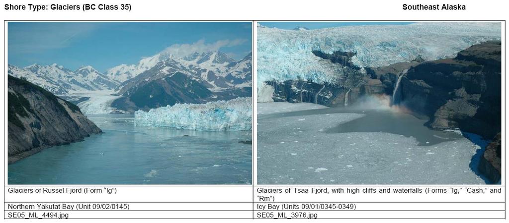
10 Phase II: ShoreZone Protocols - Shore Types

11 Phase II: biophysical mapping Physical and biological features of across-shore zones are mapped with respect to relative tidal position

12 Phase II: habitat mapping - Biobands SED ZOS VER FUC RED SBR

13 Phase II: A Rigorous Geospatial Database


14 ShoreZone Summary Reports Shore Type

15 Phase III: ShoreZone online ShoreZone.org partner website Main portal - NOAA Fisheries web enabled GIS, flex site" Other portals


16 Integrated Datasets and Web Enabled GIS

17 Web Enabled GIS - Flex Desktop

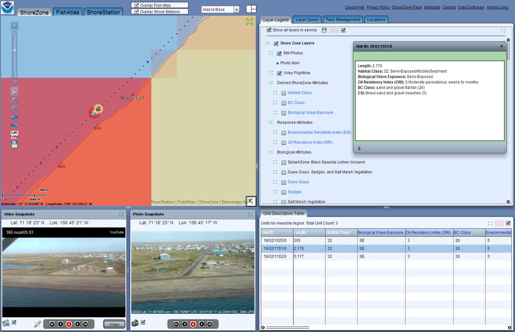
18 Alaska ShoreZone - Flex Desktop
19 Alaska ShoreZone - Flex Desktop

20 ShoreZone on ERMA Environmental Response Mgmt Application

21 ShoreZone on ERMA Imagery on Flicker

22 ShoreZone on ERMA video on vimeo

23 ShoreZone on BSEE (Bureau of Safety and Environmental Enforcement)

24 ShoreZone on AOOS CIRCAC response tool

25 ShoreZone on AOOS Arctic Portal

26 Recent ShoreZone Online Services NOAA website: NOAA mobile: internet and stand alone YouTube streaming video Download video clips Download shapefiles, xshore Fish Atlas and Shore Station overlay Local photos and units Internet photos\youtube & units Low resolution imagery Medium resolution imagery Linking video and photo play Full resolution imagery WMS basemap layers


27 There s an App for That! Seriously? Smart phones/ tablets Carry Map Load and go

28 Additional Resources online OMG!

29 Applications of ShoreZone Originally developed for oil spill planning and response First responders USCG, federal and state agencies Resource Managers sensitive habitats, invasive species Scientists site selection, monitoring, species distribution Educators and students coastal environment

30 ShoreZone Progress Sept Are we done yet?


31 ShoreZone Outreach Friend us Webinars Custom training

 865-5703 (907)")
32 Alaska ShoreZone Contact: I can help! Alaska Field Office 715 L Street Suite 100 Anchorage, AK Amalie Couvillion ShoreZone Partnership Coordinator (907) (907) acouvillion@tnc.org

33 FY 2014 ShoreZone Funding Partners NMFS AK Region NMFS Auke Bay Labs NOAA NOS NOAA AK Region Collaboration Team US DOI FWS Yukon Delta US DOI FWS NWR US FWS ALCC US FWS WALCC US DOI NPS US DOI BOEM US DOI BSEE PWS RCAC CI RCAC TNC UAF GINA

34 Diamond in the Rough starting to shine Future Goals Polished diamond - always needs buffing Temporal imagery Aleutians Western AK complete Norton Sound; ~80% AK Arctic, St. Lawrence SEAK complete! Arc Server; 60% AK imaged Record summer surveys Web database online; Fish Atlas ShoreZone workgroup formed 2001 First Survey Cook Inlet RCAC

35 A True Measure of Success is: We used ShoreZone to

36 Recent Testimonial graduate student Nicole Bitler - Committee on Evolutionary Biology, The University of Chicago The ShoreZone habitat mapping resource has been incredibly helpful for my research on the phenotypic consequences of range expansion in two marine intertidal whelks, Nucella lamellosa and Nucella ostrina. As a graduate student at the University of Chicago, the ShoreZone maps helped me pinpoint ideal sites for collection and have also allowed me to retrospectively assess the biological and environmental characteristics of sites that I visited during my field work in Alaska. The categorization of wave exposure across coastal sites is one of the features of the maps that has been most useful for my work, since wave exposure has been shown to strongly influence morphology in the whelks I am studying. The photographs and videos associated with the sites are also a fantastic resource, and I have used them in communicating my research to scientific colleagues and non-scientists.


37 ShoreZone Referenced in 2014 Publication Committee on Responding to Oil Spills in the U.S. Arctic Marine Environment Ocean Studies Board Division of Life and Earth Studies Marine Board Transportation Research Board National Research Council


38 Chukchi coast Thank You Questions?
39 Web Enabled GIS: desktop orientation

40 Query = all sites with Saffron cod

41 Entire Database: Saffron cod

42 Filter & Download = all sites with Saffron cod
43 Filter: all sites in Chukchi Sea with Saffron cod

44 All Saffron cod caught at station B16

45 All Saffron cod caught at station, on 9/14/2009

46 Shore Station dataset
47 ShoreZone
48 ShoreZone

49 Fish Atlas: Temperature loggers
50 Fish Atlas: Eelgrass monitoring
STAMP Spa)al Tools for Arc)c Mapping & Planning. Creating an interactive data tool to improve access and usability of Arctic data
al Tools for Arc)c Mapping & Planning. Creating an interactive data tool to improve access and usability of Arctic data") STAMP Spa)al Tools for Arc)c Mapping & Planning Creating an interactive data tool to improve access and usability of Arctic data Mission Provide easy access to physical, chemical, and biological data Network
STAMP Spa)al Tools for Arc)c Mapping & Planning Creating an interactive data tool to improve access and usability of Arctic data Mission Provide easy access to physical, chemical, and biological data Network
Modeling habitat suitability for the European green crab using the ShoreZone mapping system
 Modeling habitat suitability for the European green crab using the ShoreZone mapping system Jodi N. Harney, Ph.D. and John R. Harper, Ph.D. Coastal and Ocean Resources Inc. Mary Morris, R.P. Bio. Archipelago
12/2/15. Providing observa.ons, data and informa.on products to meet agency and stakeholder needs
 12/2/15 Providing observa.ons, data and informa.on products to meet agency and stakeholder needs 1 Part of the Integrated Ocean Observing System (IOOS) Governed through a Memorandum of Agreement Fiscal
ALASKA OCEAN OBSERVING SYSTEM 2016 ANNUAL IMPACT REPORT
 ALASKA OCEAN OBSERVING SYSTEM 2016 ANNUAL IMPACT REPORT 1 ALASKA OCEAN OBSERVING SYSTEM 2016 ANNUAL IMPACT REPORT 2 ALASKA OCEAN OBSERVING SYSTEM 2016 ANNUAL IMPACT REPORT Letter from Executive Director
Projects Funded in 2012
 Arctic Landscape Conservation Cooperative Advancing Science, Understanding Change. Projects Funded in 2012 The Big Picture In 2012, the Arctic LCC funded wholly, or in part, 16 projects and study planning
Coastal Response Research Center. Nancy Kinner University of New Hampshire (UNH) Michele Jacobi NOAA ORR. September 27, 2007
 Michele Jacobi NOAA ORR. September 27, 2007") Coastal Response Research Center Nancy Kinner University of New Hampshire (UNH) Michele Jacobi NOAA ORR September 27, 2007 1 Coastal Response Research Center (CRRC) CRRC is partnership between NOAA s Office
Coastal Response Research Center Nancy Kinner University of New Hampshire (UNH) Michele Jacobi NOAA ORR September 27, 2007 1 Coastal Response Research Center (CRRC) CRRC is partnership between NOAA s Office
Create your own map for tidepooling, beach field trips, boating, camping, kayaking, fishing, and exploring the beaches in Southcentral Alaska.
 Create your own map for tidepooling, beach field trips, boating, camping, kayaking, fishing, and exploring the beaches in Southcentral Alaska. Here s an opportunity to download and customize your own free
Introducing the. a partnership of
 Introducing the a partnership of Background Need for online atlas identified by managers and researchers to make coastal data available Shoreline data Ocean and coastal resources Sea-level rise potential
Elizabeth Logerwell 1, Mary Baker 2 and Amy Merten 2
 Natural resource damage assessment (NRDA) in Arctic waters Elizabeth Logerwell 1, Mary Baker 2 and Amy Merten 2 1 Alaska Fisheries Science Center, National Marine Fisheries Service, NOAA, Seattle, WA,
Design and Implementation of a NOAA/NOS Cook Inlet and Shelikof Straits Circulation Modeling System
 Design and Implementation of a NOAA/NOS Cook Inlet and Shelikof Straits Circulation Modeling System Presented at a NOAA/AEA Stakeholders Meeting, August 24, 2011, Anchorage Alaska Richard Patchen and Lyon
Use of Elevation Data in NOAA Coastal Mapping Shoreline Products. Coastal GeoTools April 1, 2015
 Use of Elevation Data in NOAA Coastal Mapping Shoreline Products Coastal GeoTools April 1, 2015 - NOAA s Coastal Mapping Program & CUSP - Shoreline Uses, Delineation Issues, Definitions - Current Extraction
3 SHORELINE CLASSIFICATION METHODOLOGY
 3 SHORELINE CLASSIFICATION METHODOLOGY Introduction The ESI scale, as described in Section 2, categorizes coastal habitats in terms of their susceptibility to spilled oil, taking into consideration a number
GIS in Response to Oil Spills and other Deleterious Materials
 GIS in Response to Oil Spills and other Deleterious Materials Judd Muskat California Department of Fish and Wildlife Office of Spill Prevention and Response What I Will Cover Office of Spill Prevention
Your eye on Alaska s coasts and oceans
 1 ALASKA OCEAN OBSERVING SYSTEM 2017 ANNUAL IMPACT REPORT Your eye on Alaska s coasts and oceans Alaska ShoreZone 2 Letter from Executive Director 2017 was an exciting year for AOOS as we continue to develop
Environmental Response Management Application
 Environmental Response Management Application Coastal Response Research Center Nancy Kinner, Michele Jacobi, Rob Braswell, Kurt Schwehr & Amy Merten RRT III May 14, 2008 1 Talk Outline Overview of Center
NOAA Arctic Priorities and Potential Contributions to PPP/YOPP. Randall Dole NOAA Earth System Research Laboratory Physical Sciences Division
 NOAA Arctic Priorities and Potential Contributions to PPP/YOPP Randall Dole NOAA Earth System Research Laboratory Physical Sciences Division 1 NOAA s Arctic Goals Forecast Sea Ice Strengthen Foundational
Climate Risk Visualization for Adaptation Planning and Emergency Response
 Climate Risk Visualization for Adaptation Planning and Emergency Response NCR Flood Fact Finding Workshop Ricardo Saavedra ricardo@vizonomy.com Social Media, Mobile, and Big Data St. Peter s Basilica,
NOAA S Arctic Program in 2017
 NOAA S Arctic Program in 2017 NOAA s Arctic Mission To determine how the Arctic system is changing on time scales of weeks to decades, particularly with respect to the consequences that the loss of sea
Sea Ice Prediction Network (SIPN) Webinar: Industry Needs for Seasonal and Sub-seasonal Sea Ice Information and Predictions
 Webinar: Industry Needs for Seasonal and Sub-seasonal Sea Ice Information and Predictions") Sea Ice Prediction Network (SIPN) Webinar: Industry Needs for Seasonal and Sub-seasonal Sea Ice Information and Predictions Hajo Eicken International Arctic Research Center University of Alaska Fairbanks,
Sea Ice Prediction Network (SIPN) Webinar: Industry Needs for Seasonal and Sub-seasonal Sea Ice Information and Predictions Hajo Eicken International Arctic Research Center University of Alaska Fairbanks,
Coast Survey Providing Improved Access to Maritime Navigation Products and Services
 Coast Survey Providing Improved Access to Maritime Navigation Products and Services Kurt A. Nelson, Branch Chief CGTP Leland Snyder, Branch Chief FADS Office of Coast Survey Agenda Current Coast Survey
USGS National Geospatial Program Understanding User Needs. Dick Vraga National Map Liaison for Federal Agencies July 2015
 + USGS National Geospatial Program Understanding User Needs Dick Vraga National Map Liaison for Federal Agencies July 2015 + Topics 2 Background Communities of Use User Surveys National Map Liaisons Partnerships
an accessible interface to marine environmental data Russell Moffitt
 an accessible interface to marine environmental data Russell Moffitt The Atlas Project GOAL: To provide a single point of access to oceanographic and environmental data for use by marine resource researchers,
1) make sure folks know what s available in terms of geospatial data and resources that could contribute to their decision support toolkits;
 make sure folks know what s available in terms of geospatial data and resources that could contribute to their decision support toolkits;") Introduction 1 2001 It was born out of the recognition that several of the regions prominent resource management agencies have similar, if not shared, requirements for GIS data. Some of the underlying
Introduction 1 2001 It was born out of the recognition that several of the regions prominent resource management agencies have similar, if not shared, requirements for GIS data. Some of the underlying
Alaska Regional Coastal and Ocean Observing System 2014 NOPP REPORT
 Alaska Regional Coastal and Ocean Observing System 2014 NOPP REPORT Molly McCammon 1007 W Third Ave., Suite 100 Anchorage, AK 99501-1936 Phone: (907) 644-6703 FAX: (907) 644-6780 E-mail: mccammon@aoos.org
OCEANOGRAPHIC DATA MANAGEMENT
 OCEANOGRAPHIC DATA MANAGEMENT Presented to: Environmental Disaster Data Management Meeting Russ Beard Director, National Coastal Data Development Center Interim Science Coordinator, Gulf Restoration Council
Capturing a Holistic Understanding of a Large Marine Ecosystem The NOAA Gulf of Mexico Data Atlas
 Capturing a Holistic Understanding of a Large Marine Ecosystem The NOAA Gulf of Mexico Data Atlas NODC / National Coastal Data Development Center gulfalas.noaa.gov Need: data that contribute to long-term
Alaska Center for Climate Assessment and Policy
 Alaska Center for Climate Assessment and Policy Welcome to the webinar: CONNECTING ALASKA LANDSCAPES INTO THE FUTURE December 8, 2009 10 AM (ADT) By Nancy Fresco, Scenarios Network for Alaska Planning
Marine Geomorphology as a Determinant for Essential Life Habitat III
 Marine Geomorphology as a Determinant for Essential Life Habitat III marinecoastalgis.net/aag08 10:10 Dawn Wright, Oregon 10:30 Will McClintock, California 10:50 Daniel Sampson, Massachusetts 11:10 Gary
NGGPS Community Sea Ice Model Recommendation Workshop. Rebecca Heim / Gene Petrescu NOAA/NWS Alaska Region
 NGGPS Community Sea Ice Model Recommendation Workshop Rebecca Heim / Gene Petrescu NOAA/NWS Alaska Region NWS Alaska Region Ice Services Excerpts from NOAAs Arctic Action Plan NOAA s National Weather Service
Alaska Ocean Observing System 101 Anchorage, Alaska
 Alaska Ocean Observing System 101 Anchorage, Alaska Molly McCammon, Director Alaska Ocean Observing System (AOOS) A Regional Observing System within the Integrated Ocean Observing System www.aoos.org IOOS
North Slope Alaska Oil and Gas Exploration and GIS Charles E. Barnwell, Michael Baker Jr. Inc. ESRI Petroleum User Conference
 33 Source: US Corps Engineers, Pt.Thomson EIS, 2009 North Slope Alaska Oil and Gas Exploration and GIS Charles E. Barnwell, Michael Baker Jr. Inc. 1 Agenda Introduction to Alaska and North Slope oil and
These modules are covered with a brief information and practical in ArcGIS Software and open source software also like QGIS, ILWIS.
 Online GIS Training and training modules covered are: 1. ArcGIS, Analysis, Fundamentals and Implementation 2. ArcGIS Web Data Sharing 3. ArcGIS for Desktop 4. ArcGIS for Server These modules are covered
Introduction: The Gulf of Mexico Alliance. The Gulf GAME project MERMAid and PHINS Results & Conclusions What s next? Examples
 AAG Las Vegas March 25, 2009 Introduction: Ocean governance and Ecosystem-Based Management The Gulf of Mexico Alliance Habitat Identification and Characterization The Gulf GAME project MERMAid and PHINS
Molly McCammon Alaska Ocean Observing System October 15, 2012
 Molly McCammon Alaska Ocean Observing System October 15, 2012 Marine Operations Safe a& efficient shipping & recreational boating, search & rescue, spill response & offshore energy development Weather
Community Mapping Network. Selected Coastal Atlases and Information Systems in British Columbia, Canada
 Community Mapping Network Selected Coastal Atlases and Information Systems in British Columbia, Canada Outline Community Mapping Network cmnbc.ca Pacific Coastal Resources Atlas for BC cmnbc.ca The Living
Marine Spatial Planning (MSP): A practical approach to ecosystembased
: A practical approach to ecosystembased") Marine Spatial Planning (MSP): A practical approach to ecosystembased management Erik Olsen, Institute of Marine Research, Norway Fanny Douvere, International Oceanographic Commission Overview Why we need
Marine Spatial Planning (MSP): A practical approach to ecosystembased management Erik Olsen, Institute of Marine Research, Norway Fanny Douvere, International Oceanographic Commission Overview Why we need
State-of-the-Art GIS as an Integrating Technology
 Paper # 104: GIS for Oil Spill Prevention & Response Devon Humphrey Instructor, National Spill Control School Texas A&M University at Corpus Christi, TX Introduction and History The National Spill Control
Demystifying ArcGIS Online. Karen Lizcano Esri
 Demystifying ArcGIS Online Karen Lizcano Esri An Integrated Web GIS Platform Desktop Web Device Powered by Services Managed via Portal Access from any Device Portal Server Online Content and Services ArcGIS
Geographic Response Plan Mapping and Digital Area Contingency Plan
 Geographic Response Plan Mapping and Digital Area Contingency Plan Ryan Druyor Digital ACP Coordinator Florida Fish and Wildlife Conservation Commission Fish and Wildlife Research Institute Background
Arctic. Ocean Observing Build Out Plan. alaska ocean observing system. March 1, 2013 draft. Tom Van Pelt
 Arctic Ocean Observing Build Out Plan March 1, 2013 draft Tom Van Pelt alaska ocean observing system Tom Van Pelt Why a coastal observing system in the Arctic? The Arctic is booming with increased activity
Mapping Climate Change in a Yupik Eskimo Village
 Mapping Climate Change in a Yupik Eskimo Village Stephen C. Brown, Ph.D. University of Alaska Fairbanks Cooperative Extension Service scbrown4@alaska.edu Terence Reeve University of Alaska Fairbanks Marine
Introduction. Elevation Data Strategy. Status and Next Steps
 1 2 Introduction Elevation Data Strategy Status and Next Steps 3 Canada is the 2nd largest country in the world - 9.9 million sq km Surrounded by 3 oceans with 202 000 km of coastline Population over 35
Western Alaska Buoy Deployment and Data Streaming. Author of Report Molly McCammon, AOOS,
 1. PROJECT INFORMATION Title: Western Alaska Buoy Deployment and Data Streaming Report period December 31, 2012 May 27, 2015 Report submission date May 27, 2015 (rec d 27 May; rev d 27 May; resp d 27 May;
GIS compilation of coastline variability spanning 60 years in the Mackenzie Delta and Tuktoyaktuk in the Beaufort Sea
 GEOLOGICAL SURVEY OF CANADA OPEN FILE 7685 GIS compilation of coastline variability spanning 60 years in the Mackenzie Delta and Tuktoyaktuk in the Beaufort Sea S. Hynes, S.M. Solomon, and D. Whalen 2014
Arctic Spatial Data Infrastructure Enabling Access to Arctic Location-Based Information
 Arctic Spatial Data Infrastructure Enabling Access to Arctic Location-Based Information Arctic SDI Side Event Co-Chairs: Arvo Kokkonen Arctic SDI Board Chair & Director General, National Land Survey of
The GIS Path Forward Saskatchewan s Geomatics Strategic Plan
 The GIS Path Forward Saskatchewan s Geomatics Strategic Plan John Potter, SK Ministry of Central Services Office of Geomatics Coordination Sept.17/13 Table of Contents 1. 2011-2016, Geomatics Strategic
Marine Debris in the Gulf of Mexico
 Marine Debris in the Gulf of Mexico Peter Murphy NOAA Marine Debris Program / Genwest Biloxi, Mississippi October 25, 2009 Outline 1. Project Background 2. Process 3. 2006-2007 Alabama, Mississippi 4.
ICAN Great Lakes 2010 Workshop
 ICAN Great Lakes 2010 Workshop Chris Cortina Maryland s Chesapeake & Coastal Program MD Department of Natural Resources Maryland s Coastal Atlas: What is it? The Coastal Atlas is an online mapping and
Mapping a Nation in 3D Singapore s Journey. Bryan Chew Registrar of Titles Assistant Chief Executive Singapore Land Authority
 Mapping a Nation in 3D Singapore s Journey Bryan Chew Registrar of Titles Assistant Chief Executive Singapore Land Authority Singapore Size - 719 sq km Population - 5.5 million Density 7,600/sq km Singapore
Rural Louisiana. A quarterly publication of the Louisiana Tech Rural Development Center
 Rural Louisiana A quarterly publication of the Louisiana Tech Rural Development Center Volume 4, No. 1, Fall 2009 Editor: Aaron K. Lusby Director, Asst. Professor Newsletter design: Stephanie Tidwell Student
University of New Hampshire Scholars' Repository
 University of New Hampshire University of New Hampshire Scholars' Repository Center for Coastal and Ocean Mapping Center for Coastal and Ocean Mapping 3-2009 Environmental Response Management Application
NOAA s OCM: Services, tools and collaboration opportunities & Puerto Rico s NE Marine Corridor as a case study
 NOAA s OCM: Services, tools and collaboration opportunities & Puerto Rico s NE Marine Corridor as a case study Dr. Antares Ramos Álvarez NOAA s Office of Coastal Management September 15 th, 2016 Conservation
African Coastal Atlas developments. 10 July 2008 EEA Copenhagen, Denmark
 African Coastal Atlas developments 10 July 2008 EEA Copenhagen, Denmark Africa Overview Africa has approximately 40 000 km of coast across 32 mainland countries and four island states. Africa's coastal
Using Big Interagency Databases to Identify Climate Refugia for Idaho s Species of Concern
 Using Big Interagency Databases to Identify Climate Refugia for Idaho s Species of Concern What is a Climate Refugia? habitat that supports a locally reproducing population [or key life history stage]
Spatial Data Infrastructure Concepts and Components. Douglas Nebert U.S. Federal Geographic Data Committee Secretariat
 Spatial Data Infrastructure Concepts and Components Douglas Nebert U.S. Federal Geographic Data Committee Secretariat August 2009 What is a Spatial Data Infrastructure (SDI)? The SDI provides a basis for
Spatial Data Availability Energizes Florida s Citizens
 NASCIO 2016 Recognition Awards Nomination Spatial Data Availability Energizes Florida s Citizens State of Florida Agency for State Technology & Department of Environmental Protection Category: ICT Innovations
Coastal Habitat Mapping Program. Bristol Bay & Southwest Alaska Data Summary Report September 2012
 Coastal Habitat Mapping Program Bristol Bay & Southwest Alaska Data Summary Report September 2012 Prepared for: NOAA National Marine Fisheries Service Alaska Region On the Cover: Cape Lapin Kenmore Head
Coastal Erosion & Climate Change: PRIDE 2005 Towards an Alaska Wind/Wave Climatology
 Coastal Erosion & Climate Change: PRIDE 2005 Towards an Alaska Wind/Wave Climatology 2 nd PRIDE Workshop August 9-10, 2005 David Atkinson, Int l Arctic Research Center, Univ. Of Alaska-Fairbanks James
E.W. Johnson 1 and M. Plivelich 2
 E.W. Johnson 1 and M. Plivelich 2 Summary A regionalized approach is being established for the collaborative stewardship of the National Hydrography Dataset (NHD) by state, federal, and university partners
The Arctic Landscape Conservation Cooperative Conservation Goals
 The Arctic Landscape Conservation Cooperative Conservation Goals Adopted by the Arctic LCC Steering Committee, 24 August 2010 Background : Landscape Conservation Cooperatives and Climate Science Centers
Enabling Access to Arctic Location Based Information
 Enabling Access to Arctic Location Based Information Kevin Gallagher Arctic SDI Board Chair, United States Geological Survey Alaska Surveying and Mapping Conference, GeoJam 15 February 2017 What is Arctic
ALASKA DEEP-DRAFT ARCTIC PORT EVALUATION
 ALASKA DEEP-DRAFT ARCTIC PORT EVALUATION Joint Study of Federal and State June 20, 2012 Opportunity and Constraint Warming of Arctic region is leading to new maritime opportunities. Thawing of permafrost
Discovery and Access of Geospatial Resources using the Geoportal Extension. Marten Hogeweg Geoportal Extension Product Manager
 Discovery and Access of Geospatial Resources using the Geoportal Extension Marten Hogeweg Geoportal Extension Product Manager DISCOVERY AND ACCESS USING THE GEOPORTAL EXTENSION Geospatial Data Is Very
Positioning the Pacific: NOAA s Geospatial Activities. Juliana Blackwell, Director NOAA s National Geodetic Survey March 6, 2012
 Positioning the Pacific: NOAA s Geospatial Activities Juliana Blackwell, Director NOAA s National Geodetic Survey March 6, 2012 A Common Problem of the Early 19 th Century 1807 President Thomas Jefferson
Vision: The National Oceanography Centre will, by 2015, be recognised as the world-leading Centre for integrated ocean sciences and technology".
 National Oceanography Centre from coast to deep ocean Waterfront Campus, Southampton Vision: Joseph Proudman Building, Liverpool The National Oceanography Centre will, by 2015, be recognised as the world-leading
Geospatial Decision Support Tools for Planning of Marine Protected Areas in California
 Geospatial Decision Support Tools for Planning of Marine Protected Areas in California WILL MCCLINTOCK (UNIVERSITY OF CALIFORNIA SANTA BARBARA), MATT MERRIFIELD (THE NATURE CONSERVANCY), SOPHIE DE BEUKELAER
A Boundary Delineation System for the Bureau of Ocean Energy Management
 A Boundary Delineation System for the Bureau of Ocean Energy Management Doug Vandegraft Chief, Mapping and Boundary Branch BOEM Esri Ocean GIS Forum - 2015 Outline Introduction BOEM Marine Cadastre Background
Climate Change in Newfoundland & Labrador
 Climate Change in Newfoundland & Labrador Impacts and Adaptation Newleef Conference 08 October 2015 Met-Ocean Services The Team 55 personnel; 24/7 operational weather forecast desk; Equipment technician
Exploitation of Ocean Predictions by the Oil and Gas Industry. GODAE OceanView Symposium 2013
 Exploitation of Ocean Predictions by the Oil and Gas Industry GODAE OceanView Symposium 2013 Introduction Information needs Challenges Acknowledgements IMarEST/SUT Metocean Awareness Course Colleagues
Exxon Valdez Oil Spill Restoration Project Annual Report
 Exxon Valdez Oil Spill Restoration Project Annual Report Ecology and Demographics of Pacific Sand Lance, Ammodytes hexapterus Pallas, in Lower Cook Inlet, Alaska Restoration Project 99306 Final Report
Information. Information Technology. Geographic. Services (GIS) 119 W Indiana Ave Deland, FL 32720
 119 W Indiana Ave Deland, FL 32720") Information Technology Geographic Information Services (GIS) 119 W Indiana Ave Deland, FL 32720 A GIS consists of 5 primary components: Hardware Software People Data Methods or Business Processes --- Hardware
Information Technology Geographic Information Services (GIS) 119 W Indiana Ave Deland, FL 32720 A GIS consists of 5 primary components: Hardware Software People Data Methods or Business Processes --- Hardware
Brian D. George. GIMS Specialist Ohio Coastal Atlas Project Coordinator and Cartographer. Impacts and Outcomes of Mature Coastal Web Atlases
 Ohio Coastal Atlas Project Brian D. George GIMS Specialist Ohio Coastal Atlas Project Coordinator and Cartographer Ohio Department of Natural Resources Office of Coastal Management Sandusky, OH Impacts
Mapping Maine s Working Waterfront: for Our Heritage and Economy
 Mapping Maine s Working Waterfront: for Our Heritage and Economy Abstract Mapping Maine s Working Waterfronts is a collaborative project led by the Island Institute that inventories the state s current
Sea Level Space Watch: Service Offering
 Space for Smarter Government Programme Sea Level Space Watch: Service Offering General Sea Level Space Watch : Operational service developed to support national flood defence planning. Systematically updated
Appendix I: Geographic Information System Data Sources
 Appendix I: Geographic Information System Data Sources Draft Environmental Impact Statement/Overseas Environmental Impact Statement Hawaii-Southern California Training and Testing TABLE OF CONTENTS...
Coastal Barrier Island Network (CBIN): Management strategies for the future
: Management strategies for the future") Coastal Barrier Island Network (CBIN): Management strategies for the future Heather Joesting*, Amy Williams**, Rusty Feagin**, and William K. Smith* *Department of Biology, Wake Forest University, Winston
Coastal Barrier Island Network (CBIN): Management strategies for the future Heather Joesting*, Amy Williams**, Rusty Feagin**, and William K. Smith* *Department of Biology, Wake Forest University, Winston
2007 / 2008 GeoNOVA Secretariat Annual Report
 2007 / 2008 GeoNOVA Secretariat Annual Report Prepared for: Assistant Deputy Minister and Deputy Minister of Service Nova Scotia and Municipal Relations BACKGROUND This report reflects GeoNOVA s ongoing
IMPLEMENTING GOVERNMENT-WIDE ENTERPRISE GIS; THE FEDERATED MODEL
 IMPLEMENTING GOVERNMENT-WIDE ENTERPRISE GIS; THE FEDERATED MODEL James E. Mitchell, Ph. D. IT GIS Manager Louisiana Department of Transportation and Development presented at the ESRI International Users
Using MAGIC to Access Spatial Imagery: Putting ER Mapper Image Web Server, ArcIMS and MrSID to work in your Library
 Using MAGIC to Access Spatial Imagery: Putting ER Mapper Image Web Server, ArcIMS and MrSID to work in your Library Patrick McGlamery Shirley Quintero University of Connecticut Libraries Building the Connecticut
NOAA/University of New Hampshire Joint Hydrographic Center & Center for Coastal and Ocean Mapping. MAPPS Summer Conference July 23, 2013
 NOAA/University of New Hampshire Joint Hydrographic Center & Center for Coastal and Ocean Mapping MAPPS Summer Conference July 23, 2013 07/23/2013 2 07/23/2013 3 Center Goals To be a world leader in the
ELEVATION IS FOUNDATIONAL. A DEM that is inaccurate or of poor resolution will pass those characteristics onto other data layers
 ELEVATION IS FOUNDATIONAL A DEM that is inaccurate or of poor resolution will pass those characteristics onto other data layers THE DEM IS FOUNDATIONAL TO ALL GIS (Geospatial Information System) LAYERS
A Boundary Delineation System for the Bureau of Ocean Energy Management
 A Boundary Delineation System for the Bureau of Ocean Energy Management Doug Vandegraft Chief, Mapping and Boundary Branch BOEM Coastal Geotools - 2015 Outline Introduction BOEM Marine Cadastre Background
Relatively little hard substrate occurs naturally in the
 CHAPTER FIVE Rock Habitats Relatively little hard substrate occurs naturally in the estuary, owing mainly to the vast quantities of fine sediment that have been deposited by the rivers. Rock habitat is
ICAN Great Lakes Workshop
 Washington Coastal latlas ICAN Great Lakes Workshop September 13 15, 15 2010 Current Washington Coastal Atlas http://www.ecy.wa.gov/programs/sea/sma/atlas_home.html 1 st version of WA Coastal Atlas was
What s New in Topographic Information - USGS National Map
 + What s New in Topographic Information - USGS National Map SARGIS Workshop November 14, 2016 Rob Dollison, 703-648-5724 rdollison@usgs.gov + USGS 2 National Geospatial Program The National Geospatial
THE USE OF GEOSPATIAL DATA TO SUPPORT VULNERABILITY MAPPING OF THE OREGON COAST. Kelvin Raiford MS Candidate Geography Department of Geosciences
 THE USE OF GEOSPATIAL DATA TO SUPPORT VULNERABILITY MAPPING OF THE OREGON COAST Kelvin Raiford MS Candidate Geography Department of Geosciences INTRODUCTION This study is an outcome of the project Geospatial
It s true, these activities are all facets of marine science. But they represent a pretty small part of the picture.
 Welcome. Thanks for coming to CBNERR s Discovery Lab. I m Lisa Lawrence and I m a marine educator at VIMS. Tonight, I m going to give you just glimpse of what it s like to be a marine scientist and tell
The Changing Face of Geospatial Technology
 The Changing Face of Geospatial Technology Vincent A. DiNoto, Jr. Director of GeoTech Center Vince.dinoto@kctcs.edu Based upon work supported by the National Science Foundation under Grant DUE ATE 1304591.
Bathymetry. EMODnet Stakeholder Conference & Sea-basin Workshops February Bathymetry
 EMODnet Stakeholder Conference & Sea-basin Workshops 14-15 February 2017 Arctic checkpoint Belinda Kater On behalf of all Checkpoints http://www.emodnet.eu 1 ? is the study of the "beds" or "floors" of
HIGH RESOLUTION BASE MAP: A CASE STUDY OF JNTUH-HYDERABAD CAMPUS
 HIGH RESOLUTION BASE MAP: A CASE STUDY OF JNTUH-HYDERABAD CAMPUS K.Manjula Vani, Abhinay Reddy, J. Venkatesh, Ballu Harish and R.S. Dwivedi ABSTRACT The proposed work High Resolution Base map: A Case study
Understanding coastal erosion in Alaska
 Understanding coastal erosion in Alaska Alaska Center for Climate Assessment and Policy Statewide Teleconference October 9, 2007. David E. Atkinson International Arctic Research Center / Atmospheric Science
Efficiencies in Data Acquisition and Transformation
 Efficiencies in Data Acquisition and Transformation Andrew LEYZACK Canada Key words: Hydrography, IHO S-57, Nautical Chart SUMMARY For many hydrographic offices, the introduction of electronic nautical
Marine Transportation and Ocean Use
 Marine Transportation and Ocean Use Data Needs for Multi-Disciplinary Long-Term Planning 4 th Biennial TRB-CMTS Research and Development Conference Matt Campo Rutgers University 6/22/2016 Overview What
The Research Agenda of the Wisconsin Coastal Atlas
 The Research Agenda of the Wisconsin Coastal Atlas David Hart GIS Specialist University of Wisconsin Sea Grant Institute International Coastal Atlas Network Workshop 4 Trieste, Italy Tuesday, November
Andy Mahoney, Hajo Eicken, Josh Jones
 First Annual Partners Meeting Presentation Integrated Framework to Identify, Track and Communicate Sea-Ice Hazards Arctic Domain Awareness Center (ADAC) A DHS Center of Excellence Andy Mahoney, Hajo Eicken,
Presentation Outline. Project Overview. Sea Level Rise Assessment & Decision Tools. Community Engagement. Tina Whitman, Friends of the San Juans
 Healthy Beaches for People & Fish Sea Level Rise Adaptation Tools for San Juan County, WA Tina Whitman & Andrea MacLennan December 10, 2015 Presentation Outline Project Overview Tina Whitman, Friends of
National Marine Sanctuary Program
 National Marine Sanctuary Program NMSP/USGS Joint Seabed Mapping Initiative: September 2004 AA National Ocean Service National Marine Sanctuaries Interim Report September 2004 Background: Since 2002,
Village Weather, Snow, Ice, Breakup, Flooding, Fire sites
 Village Weather, Snow, Ice, Breakup, Flooding, Fire sites What is the weather like now in Villages?... 1 BREAKUP:... 2 Flooding... 3 Fires... 5 Weather Predictability, Weather and Ice Advisories and How
the map Redrawing Donald Hobern takes a look at the challenges of managing biodiversity data [ Feature ]
![the map Redrawing Donald Hobern takes a look at the challenges of managing biodiversity data [ Feature ]](/thumbs/82/86628837.jpg "the map Redrawing Donald Hobern takes a look at the challenges of managing biodiversity data [ Feature ]") Redrawing the map Donald Hobern takes a look at the challenges of managing biodiversity data 46 Volume 12 > Number 9 > 2008 www.asiabiotech.com Cicadetta sp., Canberra, Australia, December 2007 Photograph
Redrawing the map Donald Hobern takes a look at the challenges of managing biodiversity data 46 Volume 12 > Number 9 > 2008 www.asiabiotech.com Cicadetta sp., Canberra, Australia, December 2007 Photograph
Aboriginal communities strengthen governance with location-based tools in the 21st century
 Aboriginal communities strengthen governance with location-based tools in the 21st century Today, Aboriginal communities are taking advantage of the geomatics technologies that underpin popular online