A Boundary Delineation System for the Bureau of Ocean Energy Management
|
|
|
- Julius Wade
- 5 years ago
- Views:
Transcription

1 A Boundary Delineation System for the Bureau of Ocean Energy Management Doug Vandegraft Chief, Mapping and Boundary Branch BOEM Esri Ocean GIS Forum
2 Outline Introduction BOEM Marine Cadastre Background Federal mapping on the Outer Continental Shelf (BLM to MMS to BOEM) Map products Submerged Lands Act Boundary and OCSLA Section 8(g) Zone Challenges Building a New System Contract with Esri, Inc. for a Boundary Delineation System

.")
3 Who is BOEM? Bureau of Ocean Energy Management is the bureau within DOI responsible for the exploration and development of energy and marine mineral resources on the Outer Continental Shelf (OCS). Minerals Management Service Bureau of Ocean Energy Management, Regulation and Enforcement
4 Authority Outer Continental Shelf Lands Act of 1953: all submerged lands lying seaward and outside of the area of lands beneath navigable waters and of which the subsoil and seabed appertain to the United States and are subject to its jurisdiction and control.
5
6 The Marine Cadastre Extends from the official baseline of the nation's coastline to the full extent of the OCS. Includes the block grids and official boundaries. Enables BOEM to define, describe, analyze, and account for every acre/hectare of federal offshore submerged lands.

7 The Marine Cadastre includes the block grids and official boundaries, which provide the base for nearly all of the BOEM offshore maps and leasing processes.

8 The Marine Cadastre includes the block grids and official boundaries, which provide the base for nearly all of the BOEM offshore maps and leasing processes.

9 The Marine Cadastre includes the block grids and official boundaries, which provide the base for nearly all of the BOEM offshore maps and leasing processes.
10 1954 Bureau of Land Management creates first Leasing Maps West Cameron Area, LA
11 State Plane Coordinate System Blocks contain 5000 acres South Padre Island Area, TX
12 Submerged Lands Act Passed by Congress in 1953 Granted title to the natural resources located within three nautical miles of a coastal state (nine nautical miles for Texas and the Gulf Coast of Florida also Puerto Rico). SLA boundary is projected seaward from officially recognized baseline points along the mean lower low water line of the coast line.
13 1963 First Leasing Maps with the Submerged Lands Act Boundary Tillamook Area, OR
14 Newport Area, OR
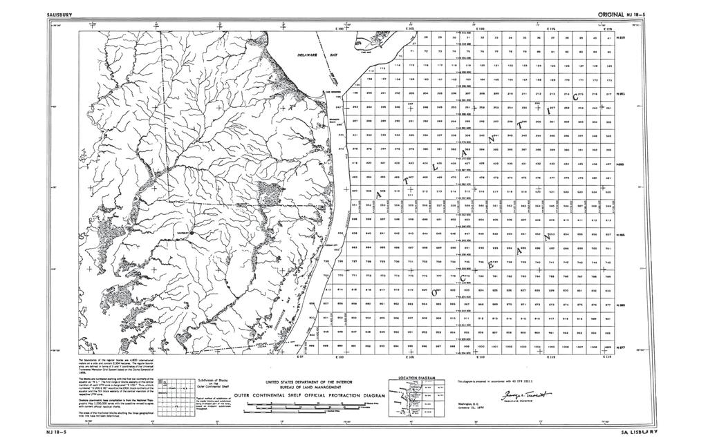
15

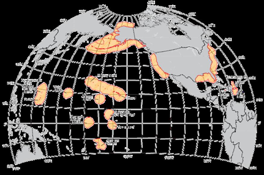
16 Extent of Leasing Maps in the Gulf of Mexico
 grid system for the first Lease Maps generated for the Gulf of")
17 Universal Transverse Mercator 1967 BLM utilizes the Universal Transverse Mercator (UTM) grid system for the first Lease Maps generated for the Gulf of Alaska.
18 Middleton Island, AK

19 Yakutat, AK
20 Computer Mapping Software Based on FORTRAN programming language code Block grid is mathematically generated SLA boundary is mathematically projected from points along the coast line Manually intensive, requiring many steps Unable to project a line seaward beyond 12 nautical miles Unable to generate blocks and boundaries in the Southern Hemisphere or west of 180.
21 Official Protraction Diagram UTM grid Blocks are increased to 5760 acres Measure 1 in latitude by 2 in longitude south of 48 latitude; increase to 3 in longitude north of 48 Printed at 1:250,000 scale

22 Manteo, NC
23 Salisbury, NJ
24 Section 8(g) Zone 1978: OCS Lands Act amended. Section 8(g): rents, royalties, and other revenue obtained from leases located within three nautical miles of the seaward boundary of any coastal state will be shared between the state and the Federal government. Area between three and six nautical miles offshore referred to as the 8(g) Zone. 1986: Section 8(g) amended to specify that the coastal state would receive 27% of the revenues generated.
25
26 Supplemental Official Protraction Diagram Generated for OCS blocks that contain at least one boundary Reflect the position of a federal boundary, or boundaries Coordinate values for where the boundary enters and exits the OCS block Arc and tangent segments projected offshore from the baseline Arc centers from the contributing baseline points
27 Lease Block Diagram West Cameron Area, LA
28 Supplemental Official Block Diagram West Cameron Area, LA
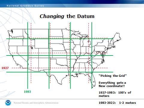
29 NAD27 and the Gulf of Mexico Minerals Management Service (MMS) created in : All Federal agencies that perform mapping activities are instructed to migrate to the North American Datum of 1983 (NAD83). 1990: Over 5000 oil and gas leases in the Gulf of Mexico MMS planned to convert all maps from NAD27 to NAD83. Conversion was completed for all Regions except the Gulf of Mexico.
30


31 1992 Technical Information Management System (TIMS) TIMS database contains all major business functions required for BOEM to perform leasing activities. Block and Boundary component contains tabular data and mapping tools Geospatial data cannot be stored in TIMS Mapping tools not functional outside of North America
32 Building a New System Replace TIMS mapping tools with GIS technology Custom tools for all processes (calculations, generate blocks and boundaries, produce maps) Contracts with Esri, Inc. signed 2009 and 2010 First set of custom tools delivered in December 2010, including the Project Boundary tool.

33 Baseline: the most seaward, or salient, points along the shoreline. Subset of isolated points Subset of points connected by lines

34 Subset of bay closing lines showing limit of inland waters.

35 Baseline and SLA Boundary, Upper Cook Inlet, Alaska
36 Building the Boundary Delineation System New contract with Esri: replace majority of custom tools with commercial-off-the-shelf (COTS) tools. New Data Model will utilize 39 separate file geodatabases, accommodating all OCS areas of the U.S. regardless of datum. Import of TIMS Block and Boundary data into the geodatabases for the Atlantic, Pacific, and Alaska Regions. Utilize the Data Interoperability extension for importing and exporting Block & Boundary data between the BDS and TIMS.
37 Building the Boundary Delineation System Generate new blocks for the principal Hawaiian Islands and subdivide all blocks into aliquot parts. Esri Project Boundary tool for creating official marine boundaries. Map Production tools will be configured to generate OPDs and SOBDs.

38 BOEM Prototype: Official Protraction Diagram
39 BOEM prototype: Supplemental Official Block Diagram
40 BOEM prototype: Supplemental Official Aliquot Diagram

41 Official Protraction Diagram with Esri Oceans Basemap Dry Tortugas, Florida

42 OPD: Pensacola, Florida

43 OPD: Pensacola, Florida
44 Contact: (703)
A Boundary Delineation System for the Bureau of Ocean Energy Management
 A Boundary Delineation System for the Bureau of Ocean Energy Management Doug Vandegraft Chief, Mapping and Boundary Branch BOEM Coastal Geotools - 2015 Outline Introduction BOEM Marine Cadastre Background
A BOEMRE and Esri White Paper June 2011 Management of Marine Resources through the Development of Marine Boundaries and Offshore Leases
 A BOEMRE and Esri White Paper June 2011 Management of Marine Resources through the Development of Marine Boundaries and Offshore Leases Esri, 380 New York St., Redlands, CA 92373-8100 USA TEL 909-793-2853
Underwater Parks: Three Case Studies, and a Primer on Marine Boundary Issues. Robert E. Johnson Leland F. Thormahlen
 Robert E. Johnson Leland F. Thormahlen Underwater Parks: Three Case Studies, and a Primer on Marine Boundary Issues Unlike boundaries on land, most marine boundaries are not marked with monuments or fences.
A National Outer Continental Shelf Sand / Sediment Inventory
 A National Outer Continental Shelf Sand / Sediment Inventory Sand Resource Areas Lease Areas Lora Turner December 15, 2016 Restoring and Protecting Our Nation s Coasts through Stewardship of OCS Resources
7B.4 ASSESSMENT OF THE GROSS U.S. OFFSHORE WIND ENERGY POTENTIAL
 7B.4 ASSESSMENT OF THE GROSS U.S. OFFSHORE WIND ENERGY POTENTIAL Marc Schwartz, Donna Heimiller, Steve Haymes, and Walt Musial National Renewable Energy Laboratory, Golden, Colorado 1. INTRODUCTION Offshore
NAVIGATION AND VESSEL INSPECTION CIRCULAR NO
 COMDTPUB P16700.4 NVIC 13-92 15 Dec 1992 NAVIGATION AND VESSEL INSPECTION CIRCULAR NO. 13-92 Electronic Version for Distribution Via the World Wide Web Subj: Captain of the Port Zone Boundaries 1. PURPOSE.
Air Quality Modeling from the Offshore Energy Sector in the Gulf of Mexico: An Overview for the Oil and Gas Industry
 Air Quality Modeling from the Offshore Energy Sector in the Gulf of Mexico: An Overview for the Oil and Gas Industry Jose L. Hernandez Bureau of Ocean Energy Management New Orleans, LA Presented at American
Integration Activities in Indonesia: The Integration of Land and Marine Spatial Data Sets as Part of Indonesian SDI Development
 Integration Activities in Indonesia: The Integration of Land and Marine Spatial Data Sets as Part of Indonesian SDI Development M. Arief Syafi i National Coordination Agency for Surveys and Mapping (B
Hypothesis/Experiment
 Investigating Regional Seafloor Hazards Using NOAA Multibeam Data and the Relationship of These Detected Seafloor Hazards with Oil and Gas Installations in the Gulf Of Mexico. Erick Huchzermeyer Hypothesis/Experiment
Integrated Hydrodynamic Modeling System
 Integrated Hydrodynamic Modeling System Applied Science Associates, Inc. 70 Dean Knauss Drive Narragansett, RI USA 02882 www.asascience.com support@asascience.com 1 Introduction HYDROMAP is a globally
Environmental Documents Prepared for Proposed Oil, Gas, and Mineral Operations by the Gulf of Mexico Outer Continental Shelf (OCS) Region
 Region") This document is scheduled to be published in the Federal Register on 03/27/2012 and available online at http://federalregister.gov/a/2012-07364, and on FDsys.gov Billing Code: 4310-MR DEPARTMENT OF THE
This document is scheduled to be published in the Federal Register on 03/27/2012 and available online at http://federalregister.gov/a/2012-07364, and on FDsys.gov Billing Code: 4310-MR DEPARTMENT OF THE
CX Debate Topic Analysis
 CX Debate Topic Analysis Larry McCarty lmac916@gmail.com or larry.mc@excite.com Resolved: The United States federal government should substantially increase its nonmilitary exploration and/or development
file:///c:/documents and Settings/kapilan/My Documents/WEB Domest...
 1 of 5 3/17/2011 1:15 PM Print Close Maritime Zones Law A LAW TO PROVIDE FOR THE DECLARATION OF THE TERRITORIAL SEA AND OTHER MARITIME ZONES OF SRI LANKA, AND ALL OTHER MATTERS CONNECTED THEREWITH OR INCIDENTAL
NR402 GIS Applications in Natural Resources Lesson 4 Map Projections
 NR402 GIS Applications in Natural Resources Lesson 4 Map Projections From http://www.or.blm.gov/gis/ 1 Geographic coordinates Coordinates are expressed as Latitude and Longitude in Degrees, Minutes, Seconds
BOEM Marine Minerals Program
 BOEM Marine Minerals Program Restoring and Protecting Our Nation s Coasts through Stewardship of OCS Sand Resources SECOORA 2018 Annual Meeting May 22-24 Doug Piatkowski Douglas.piatkowski@boem.gov 703-787-1833
MARINE GEODESY. by James C. T i s o n, J r. Director, U.S. Coast and Geodetic Survey
 MARINE GEODESY by James C. T i s o n, J r. Director, U.S. Coast and Geodetic Survey Reprinted, by kind permission, from Bulletin Géodésique, being the Journal of The International Association of Geodesy,
Law of the Sea Symposium, February, 2016, TOKYO International Law for the Resources of the Sea
 Law of the Sea Symposium, 16-17 February, 2016, TOKYO International Law for the Resources of the Sea Segment 2 Governance of Resources of the Continental Shelf (including extended continental shelf) Introduction
The Integration of Land and Marine Spatial Data Set As Part of Indonesian Spatial Data Infrastructure Development
 UNITED NATIONS E/CONF.97/6/IP. 46 ECONOMIC AND SOCIAL COUNCIL Seventeenth United Nations Regional Cartographic Conference for Asia and the Pacific Bangkok, 18-22 September 2006 Item 7 of the provisional
SECTION 4 PARCEL IDENTIFIERS 4.1 LONGITUDE AND LATITUDE
 SECTION 4 PARCEL IDENTIFIERS 4.1 LONGITUDE AND LATITUDE Most maps must be drawn in such a way that points and areas can be located accurately on the earth's surface and described objectively. A uniform
1. Geospatial technology rarely links geospatial data to nonspatial data. a. True *b. False
 Chapter 2 Where in the Geospatial World Are You? 1. Geospatial technology rarely links geospatial data to nonspatial data. 2. For geospatial technology to work, every location on Earth must be: a. inhabited
EXECUTIVE SUMMARY A SUBMISSION OF DATA AND INFORMATION ON THE OUTER LIMITS OF THE CONTINENTAL SHELF OF THE REPUBLIC OF NIGERIA PURSUANT TO
 EXECUTIVE SUMMARY A SUBMISSION OF DATA AND INFORMATION ON THE OUTER LIMITS OF THE CONTINENTAL SHELF OF THE REPUBLIC OF NIGERIA PURSUANT TO PART VI OF AND ANNEX II TO THE UNITED NATIONS CONVENTION ON THE
SIXTH REGULAR SESSION, 2017 C.B. NO A BILL FOR AN ACT
 NINETEENTH CONGRESS OF THE FEDERATED STATES OF MICRONESIA SIXTH REGULAR SESSION, 0 C.B. NO. - A BILL FOR AN ACT To amend title of the code of the Federated States of Micronesia by amending existing sections
The United States & Canada. A Regional Study of Anglo America
 A Regional Study of Anglo America Landform Regions of the United States & Canada world leaders in agricultural and industrial production because of... VAST LANDS stretch from the Atlantic Ocean on the
Where in the World? Plotting Latitude & Longitude
 Where in the World? Plotting Latitude & Longitude Background Because our planet is a sphere, we need two types of reference lines to locate positions on the Earth and to make accurate maps. These imaginary
CHAPTER 1. Geo Challenges 1A to 1D. & World Map Activity
 CHAPTER 1 Geo Challenges 1A to 1D & World Map Activity SELECT YOUR CHALLENGE World Map Activity Challenge 1A Challenge 1B Challenge 1C Challenge 1D Challenge 1A WS PG. 2 STEP #1 Label the largest continent
Use of Elevation Data in NOAA Coastal Mapping Shoreline Products. Coastal GeoTools April 1, 2015
 Use of Elevation Data in NOAA Coastal Mapping Shoreline Products Coastal GeoTools April 1, 2015 - NOAA s Coastal Mapping Program & CUSP - Shoreline Uses, Delineation Issues, Definitions - Current Extraction
Boundary Expansion of Thunder Bay National Marine Sanctuary; Correction and Expansion of Fagatele Bay National Marine
 This document is scheduled to be published in the Federal Register on 12/23/2015 and available online at http://federalregister.gov/a/2015-32265, and on FDsys.gov Billing Code 3510-NK-P DEPARTMENT OF COMMERCE
Georeferencing. Place names Postal addresses Postal codes Coordinate systems (lat/long, UTM, etc.)
") Georeferencing Georeferencing Used to describe the act of assigning locations to data or information Certain requirements include that they are: unique, have shared meaning, and are persistent through
Georeferencing Georeferencing Used to describe the act of assigning locations to data or information Certain requirements include that they are: unique, have shared meaning, and are persistent through
Georeferencing, Map Projections, Cartographic Concepts. -Coordinate Systems -Datum
 Georeferencing, Map Projections, Cartographic Concepts -Map Projections -Coordinate Systems -Datum Map projection is "the process of systematically transforming positions on the Earth's spherical surface
Case 2:09-sp RSM Document 449 Filed 03/21/18 Page 1 of 6 UNITED STATES DISTRICT COURT FOR THE WESTERN DISTRICT OF WASHINGTON AT SEATTLE
 Case :0-sp-0000-RSM Document Filed 0// Page of UNITED STATES DISTRICT COURT FOR THE WESTERN DISTRICT OF WASHINGTON AT SEATTLE UNITED STATES OF AMERICA, et al., Plaintiffs, v. STATE OF WASHINGTON, et al.,
The Looming Threat of Rising Sea Levels to the Florida Keys
 The Looming Threat of Rising Sea Levels to the Florida Keys 1. Introduction Sea levels are rising, and possibly faster than we thought before. In a recent report in 2017 by the National Oceanic and Atmospheric
IMPERIAL COUNTY PLANNING AND DEVELOPMENT
 IMPERIAL COUNTY PLANNING AND DEVELOPMENT GEODATABASE USER MANUAL FOR COUNTY BUSINESS DEVELOPMENT GIS June 2010 Prepared for: Prepared by: County of Imperial Planning and Development 801 Main Street El
Assessment of Offshore Wind Energy Resources for the United States
 Assessment of Offshore Wind Energy Resources for the United States Technical Report NREL/TP-500-45889 June 2010 Marc Schwartz, Donna Heimiller, Steve Haymes, and Walt Musial Assessment of Offshore Wind
Abstract. Introduction
 Southern California Aquaculture Site Assessment Model Caitlyn Raines University of Redlands Master of Science in Geographic Information Systems Program Abstract The Southern California Aquaculture Site
Problems and Challenges
 2018 Esri Petroleum GIS Conference Problems and Challenges May 9 10, 2018 Houston, Texas George R. Brown Convention Center Disunity of drawing standards and format Large amount of work in Cartography,
Decision Support System for Oil Spill Financial Responsibility
 Decision Support System for Oil Spill Financial Responsibility Patrick R. Thorsell 1,2 1 Department of Resource Analysis, St. Mary s University of Minnesota, Winona, MN 55987, U.S.A.; 2 ACS Government
This week s topics. Week 6. FE 257. GIS and Forest Engineering Applications. Week 6
 FE 257. GIS and Forest Engineering Applications Week 6 Week 6 Last week Chapter 8 Combining and splitting landscape features and merging GIS databases Chapter 11 Overlay processes Questions? Next week
Mindful of the interests which the Parties share as immediate neighbours, and in a spirit of cooperation, friendship and goodwill; and
 page 1 Delimitation Treaties Infobase accessed on 13/03/2002 Treaty between the Government of Australia and the Government of the Republic of Indonesia establishing an exclusive economic zone boundary
Pacific Islands Regional Maritime Boundaries Project the latest Update. Malakai Vakautawale (Mr) Maritime Boundaries Adviser
 Maritime Boundaries Adviser") Pacific Islands Regional Maritime Boundaries Project the latest Update Malakai Vakautawale (Mr) Maritime Boundaries Adviser Consortium Partners 2 What we do? Provide technical advice and support on MB
Pacific Islands Regional Maritime Boundaries Project the latest Update Malakai Vakautawale (Mr) Maritime Boundaries Adviser Consortium Partners 2 What we do? Provide technical advice and support on MB
CONTINENTAL SHELF SUBMISSION OF ANGOLA - EXECUTIVE SUMMARY -
 CONTINENTAL SHELF SUBMISSION OF ANGOLA - EXECUTIVE SUMMARY - INDEX List of Figures 2 List of Tables 3 1 Introduction 5 2 Provisions of Article 76 7 3 Angolan Institutions responsible for the Submission
Sam Bateman and. State Practice Regarding Straight Baselines In East Asia Legal, Technical and Political Issues in a
 State Practice Regarding Straight Baselines In East Asia Legal, Technical and Political Issues in a Changing Environment Sam Bateman and Clive Schofield The Australian National Centre for Ocean Resources
1) Download TrainingData Folder from: IcOldDBz4MVwLQhslNUTFoMEqgEO7
 Download TrainingData Folder from: IcOldDBz4MVwLQhslNUTFoMEqgEO7") Instructions: 1) Download TrainingData Folder from: https://drive.google.com/open?id=1bh- IcOldDBz4MVwLQhslNUTFoMEqgEO7 2) Open QGIS (this exercise is made fro QGIX version 2.18, but can be also done in
Instructions: 1) Download TrainingData Folder from: https://drive.google.com/open?id=1bh- IcOldDBz4MVwLQhslNUTFoMEqgEO7 2) Open QGIS (this exercise is made fro QGIX version 2.18, but can be also done in
Regional-scale understanding of the geologic character and sand resources of the Atlantic inner continental shelf, Maine to Virginia
 Regional-scale understanding of the geologic character and sand resources of the Atlantic inner continental shelf, Maine to Virginia Workshop on Dredging, Beach Nourishment and Bird Conservation Atlantic
NEEA Refresh aka 3D Nation Requirements and Benefits Study. Allyson Jason, Carol Ostergren, Xan Fredericks and Lou Driber November 9, 2017
 + NEEA Refresh aka 3D Nation Requirements and Benefits Study Allyson Jason, Carol Ostergren, Xan Fredericks and Lou Driber November 9, 2017 + 2 Study Context Background The National Enhanced Elevation
Appendix I: Geographic Information System Data Sources
 Appendix I: Geographic Information System Data Sources Draft Environmental Impact Statement/Overseas Environmental Impact Statement Hawaii-Southern California Training and Testing TABLE OF CONTENTS...
This Book Belonged to
 THE AMERICAN UNIVERSITY Washington College of Law Library This Book Belonged to The Private Collection of Judge Richard R, Baxter I THE AMERICAN UNIVERSITY Washington College of Law Law Library W-, D.C.
CHAIRMAN OF THE JOINT CHIEFS OF STAFF INSTRUCTION
 CHAIRMAN OF THE JOINT CHIEFS OF STAFF INSTRUCTION J-3 CJCSI 3900.01C DISTRIBUTION: A, B, C, J POSITION (POINT AND AREA) REFERENCE PROCEDURES Reference: DODD 5105.60, 11 October 1996, National Imagery and
Overview of Engineering. Risk Management for Successful Wind Energy Development, Offshore U.S.
 Overview of Engineering Considerations for Siting and Risk Management for Successful Wind Energy Development, Offshore U.S. Bi Briefing for: North Carolina Offshore Wind Task Force Tom McNeilan, P.E. General
MAPS AND COORDINATES...
 Table of Contents 1 INTRODUCTION... 2 2 MAPS AND COORDINATES... 3 3 ADVISORY ASSISTANCE FROM COMMISSION MEMBERS... 3 4 PROVISIONS OF ARTICLE 76 INVOKED... 3 5 OUTSTANDING MARITIME DELIMITATIONS... 4 6
GROUNDFISH AMENDMENT 28 REGULATION DEVELOPMENT UPDATE
 Agenda Item I.2.a NMFS Report 1 September 2018 GROUNDFISH AMENDMENT 28 REGULATION DEVELOPMENT UPDATE In drafting regulations for the Council s final preferred alternative for Amendment 28, recommended
Coast Survey Providing Improved Access to Maritime Navigation Products and Services
 Coast Survey Providing Improved Access to Maritime Navigation Products and Services Kurt A. Nelson, Branch Chief CGTP Leland Snyder, Branch Chief FADS Office of Coast Survey Agenda Current Coast Survey
Article 76, variations in annotation and implementation seen in submission documents for the claim of Extended Continental Shelf
 Article 76, variations in annotation and implementation seen in submission documents for the claim of Extended Continental Shelf Mr. Shin Tani Chairman, IHO/IAG Advisory Board on the Law of the Sea (ABLOS)
Positioning the Pacific: NOAA s Geospatial Activities. Juliana Blackwell, Director NOAA s National Geodetic Survey March 6, 2012
 Positioning the Pacific: NOAA s Geospatial Activities Juliana Blackwell, Director NOAA s National Geodetic Survey March 6, 2012 A Common Problem of the Early 19 th Century 1807 President Thomas Jefferson
Welcome to Lesson 4. It is important for a GIS analyst to have a thorough understanding of map projections and coordinate systems.
 Welcome to Lesson 4. It is important for a GIS analyst to have a thorough understanding of map projections and coordinate systems. A GIS without coordinates would simply be a database like Microsoft Excel
Chapter 3 Geographic Location Systems
 Chapter 3 Geographic Location Systems In this chapter you will learn about: Latitude and longitude Universal Transverse Mercator (UTM) U.S. Public Land Survey Other geographic location systems Geographic
MARINE SPATIAL PLANNING & MARINE CADASTRE: CHALLENGES AND ISSUES
 MARINE SPATIAL PLANNING & MARINE CADASTRE: CHALLENGES AND ISSUES Roger Longhorn Secretary General, GSDI Association rlonghorn@gsdi.org Member, IHO Marine SDI Working Group ral@alum.mit.edu Member, UNESCO
EQ: Discuss main geographic landforms of the U.S. & Canada and examine varied landforms in relation to their lifestyles.
 EQ: Discuss main geographic landforms of the U.S. & Canada and examine varied landforms in relation to their lifestyles. Places & Terms for Discussion Appalachian Mountains Great Plains Canadian Shield
GIS for Surveyors: Wetland Studies and Solutions, Inc.
 GIS for Surveyors: Concepts, Solutions, and Applications ` New Jersey Society of Professional Land Surveyors (NJSPLS) SurvCon 2013, Atlantic City, New Jersey Presented by John Cooke and Yeoanny A. Venetsanos,
Introduction After reviewing the classification of continental margins (not plate margins) in your textbook, answer the following questions:
 in your textbook, answer the following questions:") Investigating the continental margins of North America using GeoMapApp. This exercise is designed to familiarize you with the features of continental margins. Through the analysis of color-coded bathymetric
Investigating the continental margins of North America using GeoMapApp. This exercise is designed to familiarize you with the features of continental margins. Through the analysis of color-coded bathymetric
Esri Image & Mapping Forum 9 July 2017 Geiger-Mode for Conservation Planning & Design by USDA NRCS NGCE
 Esri Image & Mapping Forum 9 July 2017 Geiger-Mode for Conservation Planning & Design by USDA NRCS NGCE For over 75 years, the Natural Resources Conservation Service has been a pioneer in conservation,
REPUBLIC OF THE MARSHALL ISLANDS MARITIME ZONES DECLARATION ACT 2016.
 Republic of the Marshall Islands Maritime Zones Declaration Act 2016. 33MIRCCh.1Index TITLE 33 - MARINE ZONES AND PROTECTION OF MAMMALS CHAPTER 1 - MARITIME ZONE DECLARATION s Republic of the Marshall
The World of Geography Pre-Test/Study Guide Chapter 1 Test
 Read each statement or question. On the lines below write the letter of the best answer. 1. Geographers look at the Earth 5. What are the two specific A. by studying cities first. measurements of Earth
Chapter 02 The Sea Floor
 Chapter 02 The Sea Floor Multiple Choice Questions 1. One of the following is not one of the world's major ocean basins: A. Atlantic Ocean B. Arctic Ocean C. Indian Ocean D. Antarctic Ocean E. Pacific
Polar complications in the law of the sea: A case study of the regime for research and survey activities in the Arctic Ocean
 2010 ABLOS Conference: Contentious Issues in UNCLOS Surely Not? International Hydrographic Bureau, 25-27 October 2010 Polar complications in the law of the sea: A case study of the regime for research
IHO Perspective on a Marine Spatial Data Infrastructure
 IHO Perspective on a Marine Spatial Data Infrastructure Anthony Pharaoh (International Hydrographic Bureau) Definitions of Hydrography on the Web: The study of the surface waters of the Earth. www.geographic.org/glossary.html
Clive Schofield * and David Freestone **
 Holding Back the Waves: Options to Secure Maritime Jurisdictional Claims in the Face of Sea Level Rise Clive Schofield * and David Freestone ** *Australian National Centre for Ocean Resources and Security
Application #: TEXT
 TOWN OF FORT MYERS BEACH 2008 PROPOSED COMPREHENSIVE PLAN AMENDMENTS Application #: 2008-13-TEXT Description: Modify the Coastal Management and Future Land Use Elements to reflect the state s new definition
Marine Geospatial Software: Generating Economic Benefits from Hydrographic Data and Calculation of Maritime Boundaries
 Marine Geospatial Software: Generating Economic Benefits from Hydrographic Data and Calculation of Serge LEVESQUE and Alexis CARDENAS, Canada Key words: marine geospatial data, hydrography, economic benefits,
Warmup. geography compass rose culture longitude
 Warmup geography compass rose culture longitude ecosystem latitude 1. study of the special physical and human characteristics of a place or region 2. learned system of shared beliefs, traits, and values
Inter State Large Navigable Rivers of the United States
 Inter State Large Navigable Rivers of the United States REVIEW OF NORTH AMERICAN BASINS: GREAT LAKES AND MISSISSIPPI RIVER HELEN A. BROHL, EXECUTIVE DIRECTOR US COMMITTEE ON THE MARINE TRANSPORTATION SYSTEM
Bentley Map Advancing GIS for the World s Infrastructure
 Bentley Map Advancing GIS for the World s Infrastructure Presentation Overview Why would you need Bentley Map? What is Bentley Map? Where is Bentley Map Used? Why would you need Bentley Map? Because your
Characterization of the Nigerian Shoreline using Publicly-Available Satellite Imagery
 University of New Hampshire University of New Hampshire Scholars' Repository Center for Coastal and Ocean Mapping Center for Coastal and Ocean Mapping 1-2014 Characterization of the Nigerian Shoreline
Coastal/Marine Thematic SDIs
 Coastal/Marine Thematic SDIs Roger Longhorn Principal Consultant (SDI), Compass Informatics Ltd Information Policy Advisor, Coastal & Marine Union (EUCC) Information Expert, Intergovernmental Oceanographic
dding endencies IN THE GULF MEXICO
 GULF MEXICO dding endencies IN THE OF GULF MEXICO Where are THE MOST areas offshore IN HE GOM OF Is there a Pattern (?) On the bidding activity Agenda ý % 1 $ ( 9. ç? GULF MEXICO TO THE GOM OF Looking
How to Deal with Maritime Boundary Uncertainty in Oil and Gas Exploration and Production Areas*
 The University of Texas School of Law Presented: International Upstream Energy Transactions January 17-18, 2013 Houston, TX How to Deal with Maritime Boundary Uncertainty in Oil and Gas Exploration and
GIS Lecture 5: Spatial Data
 GIS Lecture 5: Spatial Data GIS 1 Outline Vector Data Formats Raster Data Formats Map Projections Coordinate Systems US Census geographic files US Census data files GIS Data Sources GIS 2 Vector Data Formats
Introduction. Project Summary In 2014 multiple local Otsego county agencies, Otsego County Soil and Water
 Introduction Project Summary In 2014 multiple local Otsego county agencies, Otsego County Soil and Water Conservation District (SWCD), the Otsego County Planning Department (OPD), and the Otsego County
USS Arizona Drawings and Underwater GPS Surveys Linked by ArcIMS
 ESRI UC2004 USS Arizona Drawings and Underwater GPS Surveys Linked by ArcIMS Tim Smith National Park Service Matt Brown Northrop Grumman Information Technology Outline! Introduction! Geodatabase Development!
MEMORANDUM FOR SWG
 MEMORANDUM FOR SWG-2007-1623 Subject: Jurisdictional Determination (JD) for SWG-2007-1623 on Interdunal Wetlands Adjacent to Traditional Navigable Waters (TNWs) Summary The U.S. Environmental Protection
What is a Map Projection?
 What is a Map Projection? It is how we represent a three dimensional Earth on a flat piece of paper However The process of transferring information from the Earth to a map causes every projection to distort
Chapter 16, Part Hurricane Paths. 2. Hurricane Paths. Hurricane Paths and Damage
 Chapter 16, Part 2 Hurricane Paths and Damage 1. Hurricane Paths Start over tropical water except South Atlantic and eastern South Atlantic, where water is too cold. Initially steered by easterly winds
Lab#3: GIS Projections and Coordinate Systems. Start Arcmap and create a data frame for each of the above coordinate systems.
 NRM338 Fall 2017 Lab#3 Page#1 of 18 In this lab, you will Lab#3: GIS Projections and Coordinate Systems 1) Define the geographic coordinate system of two GIS themes. 2) Determine the geographic coordinates
IWG-OCM Update For NCSS
 IWG-OCM Update For NCSS Data Supporting Science and Sound Decision-Making Ashley Chappell January 9, 2018 NOAA IOCM Coordination Team Members National Environmental Satellite, Data and Information Service:
Weather Research Center
 Weather Research Center 3227 Audley Houston, Texas 77098 Phone: 713-529-3076 Fax: 713-528-3538 E-mail: wrc@wxresearch.org Press Release For Immediate Release November 29, 2005 For Information Contact:
Solving the "Grid to Ground Problem" with Custom Coordinate Systems CV327-6 About the Speaker:
 Solving the "Grid to Ground Problem" with Custom Coordinate Systems Richard Sincovec, LSI Director of Technology, Edward James Surveying President, Quux Software CV327-6 Grid projections such as the State
Map Projections. Displaying the earth on 2 dimensional maps
 Map Projections Displaying the earth on 2 dimensional maps Map projections Define the spatial relationship between locations on earth and their relative locations on a flat map Are mathematical expressions
The Relevance of Hydrography to UNCLOS; an Indonesian Perspective By: Prof. Dr. Hasjim Djalal, MA*
 The Relevance of Hydrography to UNCLOS; an Indonesian Perspective By: Prof. Dr. Hasjim Djalal, MA* As I understand it, the theme of this 6 th ABLOS Conference 2010 is Contentious Issues in UNCLOS- surely
GIS Changing the World GIS Day November 15, 2017
 + GIS Changing the World GIS Day November 15, 2017 + Growing Up On The Farm 3 Geographic Information in DNR A 75 year history of mapping and GIS. Forest type map from 1944. State of Washington - Division
Observations on CSDI/MGDI Data Themes
 Observations on CSDI/MGDI Data Themes Roger Longhorn Secretary-General, GSDI Association - rlonghorn@gsdi.org Member, IHO Marine SDI Working Group ral@alum.mit.edu Member, UNESCO IOC IODE International
Alexandra Carvalho, Ph.D., GISP Kathy Fitzpatrick, P.E.
 Coastal Data Organization for Project Management and Coastal Planning Martin County, Florida Alexandra Carvalho, Ph.D., GISP Kathy Fitzpatrick, P.E. Outline County Coastal Programs Coastal Geodatabase
Understanding China Census Data with GIS By Shuming Bao and Susan Haynie China Data Center, University of Michigan
 Understanding China Census Data with GIS By Shuming Bao and Susan Haynie China Data Center, University of Michigan The Census data for China provides comprehensive demographic and business information
HP-35s Calculator Program Lambert 1
 Convert Latitude and Longitude to Lambert Conformal Conic Projection Co-ordinates (SPCS) Programmer: Dr. Bill Hazelton Date: July, 2010. Version: 1.2 Line Instruction Display User Instructions N001 LBL
D) 15 N, 160 W A) prevailing wind direction
 15 N, 160 W A) prevailing wind direction") Base your answers to questions 1 and 2 on the diagram below, which represents latitude and longitude lines on Earth. Points A through E represent locations on Earth. Arrows represent direction of rotation.
Base your answers to questions 1 and 2 on the diagram below, which represents latitude and longitude lines on Earth. Points A through E represent locations on Earth. Arrows represent direction of rotation.
MILITARY SPECIFICATION DIGITAL LANDMASS BLANKING (DLMB) DATA PROGRAM
 DATA PROGRAM") METRIC MIL-D-89021 15 June 1991 SUPERSEDING PS/1CJ/010 September 1983 MILITARY SPECIFICATION DIGITAL LANDMASS BLANKING (DLMB) DATA PROGRAM This specification is approved for use by all Departments and
METRIC MIL-D-89021 15 June 1991 SUPERSEDING PS/1CJ/010 September 1983 MILITARY SPECIFICATION DIGITAL LANDMASS BLANKING (DLMB) DATA PROGRAM This specification is approved for use by all Departments and
Geography 281 Map Making with GIS Project Eight: Comparing Map Projections
 Geography 281 Map Making with GIS Project Eight: Comparing Map Projections In this activity, you will do a series of projection comparisons using maps at different scales and geographic extents. In this
Notes on Projections Part II - Common Projections James R. Clynch February 2006
 Notes on Projections Part II - Common Projections James R. Clynch February 2006 I. Common Projections There are several areas where maps are commonly used and a few projections dominate these fields. An
Unit 2. United States Physical Geography
 Unit 2 United States Physical Geography Physical Geography U.S. extends from the Atlantic to Pacific U.S. is the 3rd largest country U.S. has fertile soils, vast forests, and variety of minerals All major
Import Digital Spatial Data (Shapefiles) into OneStop
 into OneStop") Import Digital Spatial Data (Shapefiles) into OneStop» Intended User: Pipeline Licence Applicants Overview To apply for a pipeline or pipeline installation licence, applicants must upload the proposed
Import Digital Spatial Data (Shapefiles) into OneStop» Intended User: Pipeline Licence Applicants Overview To apply for a pipeline or pipeline installation licence, applicants must upload the proposed
COASTAL PLANNING & ENGINEERING OF NORTH CAROLINA, INC
 4038 MASONBORO LOOP ROAD, WILMINGTON, NC 28409 910-791-9494 PHONE 910-791-4129 FAX July 15, 2014 David W. Cooke Regional Supervisor for Resource Evaluation Bureau of Ocean Energy Management Gulf of Mexico
A PRIMER ON COORDINATE SYSTEMS Commonly Used in Michigan
 A PRIMER ON COORDINATE SYSTEMS Commonly Used in Michigan David P. Lusch, Ph.D., GISP Department of Geography Remote Sensing & GIS Research and Outreach Services Group Michigan State University September,