Introduction After reviewing the classification of continental margins (not plate margins) in your textbook, answer the following questions:
|
|
|
- Jonathan Nelson
- 5 years ago
- Views:
Transcription
1 Investigating the continental margins of North America using GeoMapApp. This exercise is designed to familiarize you with the features of continental margins. Through the analysis of color-coded bathymetric maps, bathymetric profiles, and readings about scientific investigations along the coast of North America, you will gain a better understanding of the processes responsible for the modern topography of the seafloor in the immediate surroundings of continental masses. Introduction After reviewing the classification of continental margins (not plate margins) in your textbook, answer the following questions: 1. What are continental margins? 2. How many types of continental margins (not plate margins) are discussed in the textbook and course notes? 3. In terms of topographic features, what is the difference between passive and active continental margins? The Southern Coast of Alaska Launch GeoMapApp ( and select the Mercator projection. Magnify the area between approximately (176 W, 62 N) and (132 W, 50 N). You should see the southern coast of Alaska. Construct three or four topographic profiles with starting points on land (or island) between 151 and 159 W longitude. You can choose the profile locations yourself, or you can use the points listed below. Important things to keep in mind: o start the profile on land (or island), close to the shoreline (you must see the 0 m elevation in the profile); o don t extend too far or not far enough from the coast (you want to show the features of the continental margins from the coast to the deep ocean floor); o create profiles perpendicular (90 ) to the coastline (don t worry if the profiles aren t parallel); and o print or save each profile (not the map) before you move on to the next one. Suggested starting points: W, 56.3 N 157 W, 57.3 N 155 W, 58.3 N 4. Using the colors indicated below, mark the location of the features in the list that are present along the profile, then save your work for later submission. (Note: Not all of them are necessarily there.) Please mark above or below the profile line. Continental shelf..red Shelf edge a purple dot Continental slope..yellow Continental rise green Trench..blue
2 Ocean floor..orange 5. What type of continental margin is this? Justify your answer. You will now add the location of earthquakes foci and active volcanoes to the map. Click on Portals on the menu at the top of the screen and select Earthquake Locations, Epicenter Depths, and Magnitudes. A series of colored dots will appear on the map. Notice the legend on the upper right corner of the screen. Click on Datasets on the menu at the top of the screen and select Volcanoes and Seamounts, then Location and Aster Satellite Images of Major Volcanoes. A series of gray dots will appear on the map, marking the position of major volcanoes. You can change the dot color by going to the Toolbox (right side of the screen) and clicking on Configure and then Symbol Color. 6. Carefully observe the distribution of volcanoes, earthquake foci, and earthquake depths. Do these data support your classification of this continental margin? Justify your answer. The East Coast Zoom out until you see the entire world map, then magnify the area between approximately 86 W, 43 N and 60 W, 32 N. You should see the East Coast in the central part of the map. Construct three or four topographic profiles with starting points on land. Stay in the area north of Cape Hatteras and south of Cape Cod. You can choose the profile locations yourself, or you can use the points listed below. Follow the instructions provided for the Alaskan margin. Make sure you extend your profile to the ocean floor (about 4,000 m water depth), or you won t see all of the important features. Suggested starting points: 76 W, 37.3 N 74.5 W, 39.8 N 72 W, 41.6 N 7. Using the same colors indicated above, mark the location of the features in the list that are present along the profile, then save your work for later submission. (Note: Not all of them are necessarily there.) Please mark above or below the profile line. 8. What type of continental margin is this? Justify your answer. 9. Add the distribution of earthquakes and volcanoes to your map. Do these data support your classification of this continental margin? Justify your answer. Continental margins can be characterized by the presence of numerous deep sea canyons that cut through the continental slope; some are particularly deep and long and encroach on the continental shelf. Several of these larger canyons are visible along the Atlantic continental margin of North America. Zoom into the area between approximately 77 W, 41 N and 67 W, 35 N and locate one area where two or more of these canyons are found next to each other. Enlarge this area and save or print the map. (Note: The southern part of the map seems to have better resolution when magnified, so you may want to look there first.)
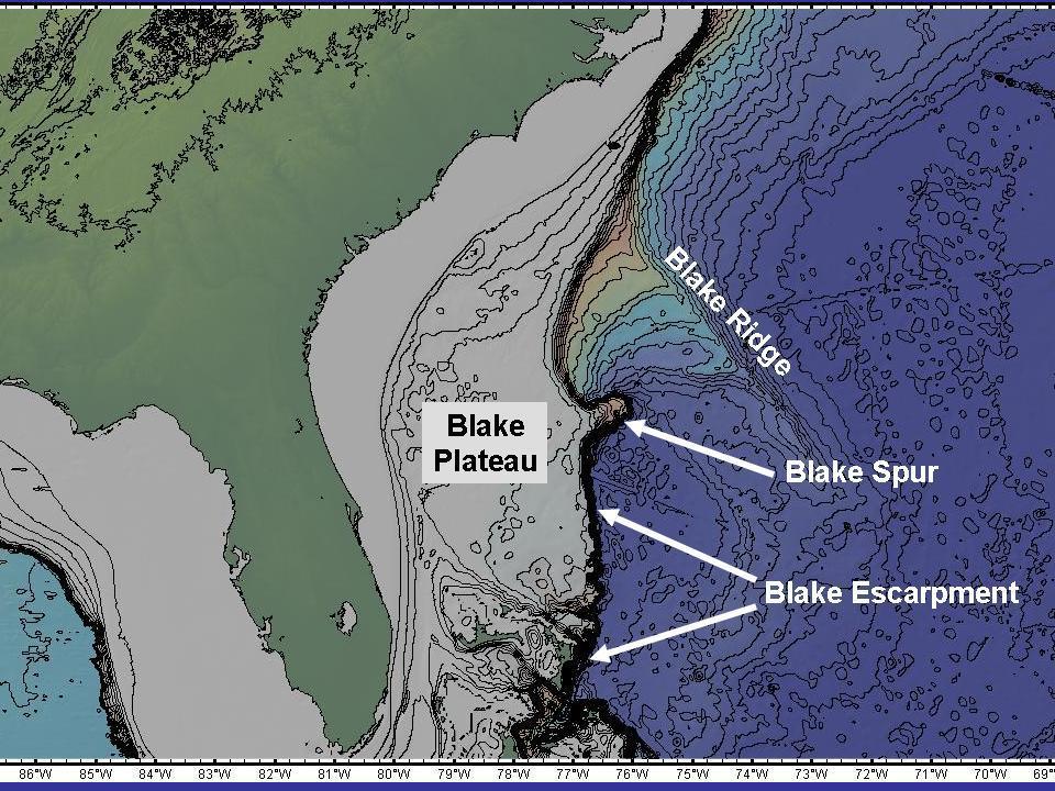
3 On the map, draw red lines parallel to the canyons axes. Use the yellow line to identify one canyon that will be the subject of further investigation. Add the map to the other figures to be submitted. Magnify the canyon you selected at the previous point until it occupies most of the screen (Figure 1, see below). Make sure the GeoMapApp program doesn t occupy the entire screen; if it does, reduce the window size. Activate the grid command (Figure 2, see below) and two new windows will open. In the Global Grids window, set the vertical exaggeration to five and click on three-dimensional (Figure 3, see below). You can rotate the image vertically and horizontally using the commands on the lower left of the screen (Figure 4, see below). Do so to get a good idea of the canyon characteristics; when you have a good point of view, render the image. Save or print the image. Carefully observe the figure; on the continental rise, you should see a layer of sediments deposited around the main channel. Use a yellow line to mark the edges of this deposit. 10. What is the name of this feature, and what is its origin? Justify your answer. The Floridian East Coast Zoom out until you see the entire continent of North America, then magnify the area around Florida, between approximately 92 W, 35 N and 64 W, 22 N. Figure 5 (see below) shows the names of the main bathymetric features in this area. 11. Look at the continental shelf to the east of Florida. Where is the continental shelf widest? How wide? (Use the profile tool in GeoMapApp to estimate the width.) 12. Where is the continental shelf narrowest? How narrow? 13. Print the map and draw a yellow line marking the position of the shelf break. Mark the position of the Blake Escarpment with a green line, and circle the Blake Spur in blue. Draw a bathymetric profile from approximately 81.6 W, 28 N to 73 W, 30 N and save or print it. 14. On the profile, where are the shelf edge (break) and the Blake Plateau located? (Read the distance on the horizontal axis.) 15. In your profile, what are the width and average depth of the Blake Plateau? What is the depth of the sea floor to the east of the plateau? Go to the U.S. Geological Survey s GLORIA Mapping Program. Scroll down and read about the oceanography of the Blake Plateau and Blake Escarpment. 16. What processes are responsible for the formation of the plateau? 17. Name the current that scours the Blake Plateau, preventing sediment deposition. Where does it originate? Is it a warm or cold water current? (You will have to search the web to answer the second part of this question; start at
4 18. Along the Blake Escarpment, where is the steepest region located and what process is responsible for the presence of this cliff? 19. In the southern part of the Blake Plateau, immediately north of the Bahamas Islands, there is a series of canyons. What is their origin? 20. Which of the following processes is ultimately responsible for the formation of the Blake Escarpment? 21. Geologic evidence indicates that until about 100 million years ago the Blake Plateau was a shallow water area. What process most likely moved the plateau to its modern depth? The Gulf Coast Go back to GeoMapApp and zoom out until you can see the Gulf of Mexico. Zoom into the area between 99 W, 30 N and 86 W, 24 N. The seafloor in the northern part of the map is marked by the presence of numerous crater-like depressions that give it a lunar-like appearance. Construct a series of two or more bathymetric profiles from the land to the deeper part of the Gulf, perpendicular to the shoreline. 22. Save or print the profiles, and mark the area where the depressions are found. 23. Based on the profiles, on what part of the continental margin are the depressions located (shelf, slope, raise, trench)? Justify your answer. 24. Draw two or three additional profiles across the depressions (you may want to magnify the area where they are located). What are their average diameter and depth? In 2002, a National Oceanic and Atmospheric Administration expedition to this area investigated the characteristics of one of these depressions called the Brine Pool. Go to the 2002 Gulf of Mexico exploration, read the Brine Pools section ( and answer the following questions: 25. What are brine lakes or pools? 26. How did these depressions form? 27. What is the origin of the salt layers found in the Gulf of Mexico under more recent marine sediments?


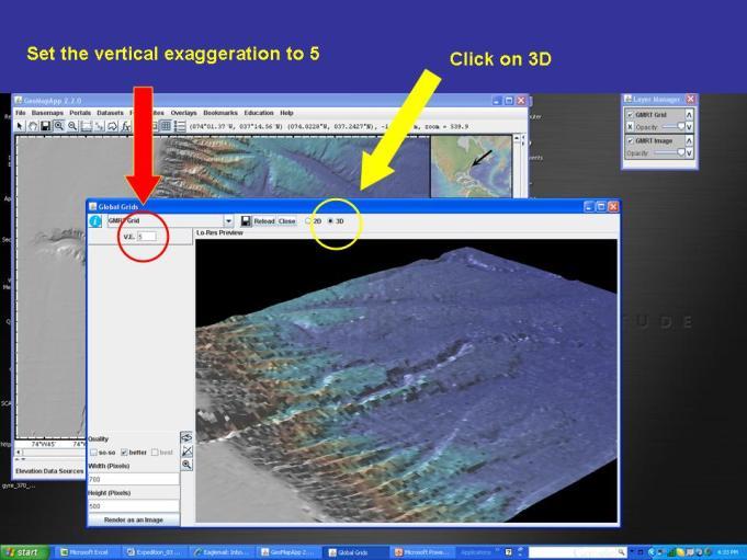
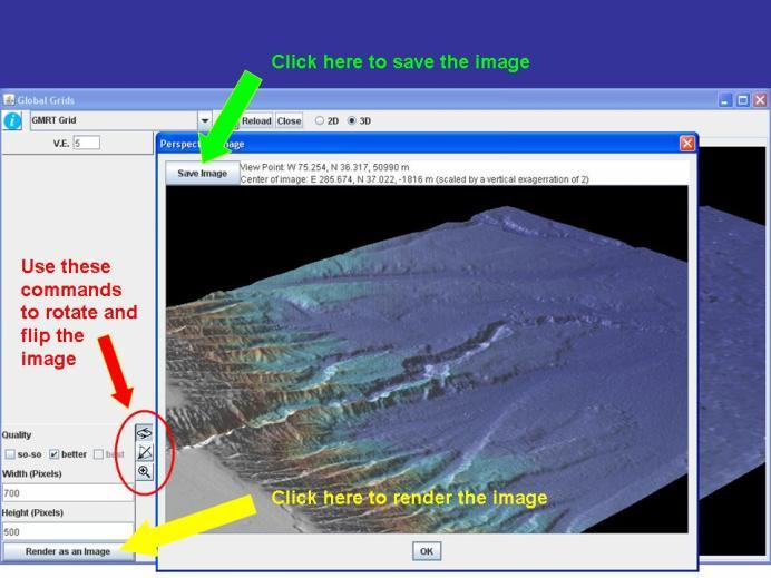
5 Figure 1 Figure 2 Figure 3 Figure 4 Figure 5
MARINE GEOLOGY & GEOGRAPHY
 MARINE GEOLOGY & GEOGRAPHY Bathymetry BATHYMETRY BATHYMETRY THE UNDERWATER EQUIVALENT TO TOPOGRAPHY THE STUDY OF WATER DEPTH A BATHYMETRIC MAP SHOWS FLOOR RELIEF OR TERRAIN AS CONTOUR LINES Bathymetry
1. Name at least one place that the mid-atlantic Ridge is exposed above sea level.
 Interpreting Tectonic and Bathymetric Maps. The purpose of this lab is to provide experience interpreting the bathymetry of the seafloor in terms of tectonic and geologic settings and processes. Use the
Lab # - Ocean Bottom Topography. Background Information:
 Name Lab Grade /10 Date Period Lab # - Ocean Bottom Topography Background Information: Ocean depth varies markedly from one location to another. Over large areas water depth is less than 200m (650 ft);
Oceanography. Oceanography is the study of the deep sea and shallow coastal oceans.
 Oceanography Oceanography is the study of the deep sea and shallow coastal oceans. Studying the Ocean Floor To determine the shape and composition of the ocean floor, scientists use techniques such as
Chapter 02 The Sea Floor
 Chapter 02 The Sea Floor Multiple Choice Questions 1. One of the following is not one of the world's major ocean basins: A. Atlantic Ocean B. Arctic Ocean C. Indian Ocean D. Antarctic Ocean E. Pacific
Oceanography, An Invitation to Marine Science 9e Tom Garrison. Ocean Basins Cengage Learning. All Rights Reserved.
 Oceanography, An Invitation to Marine Science 9e Tom Garrison 4 Ocean Basins Key Concepts Tectonic forces shape the seabed The ocean floor is divided into continental margins and deep ocean basins The
Surface Circulation in the North Atlantic & off of Southern California: Two Models
 Surface Circulation in the North Atlantic & off of Southern California: Two Models Objective 1. To become familiar with large scale surface circulation patterns in ocean. 2. To be able to predict current
Marine Science and Oceanography
 Marine Science and Oceanography Marine geology- study of the ocean floor Physical oceanography- study of waves, currents, and tides Marine biology study of nature and distribution of marine organisms Chemical
1 Earth s Oceans. TAKE A LOOK 2. Identify What are the five main oceans?
 CHAPTER 13 1 Earth s Oceans SECTION Exploring the Oceans BEFORE YOU READ After you read this section, you should be able to answer these questions: What affects the salinity of ocean water? What affects
Earth s Continents and Seafloors. GEOL100 Physical Geology Ray Rector - Instructor
 Earth s Continents and Seafloors GEOL100 Physical Geology Ray Rector - Instructor OCEAN BASINS and CONTINENTAL PLATFORMS Key Concepts I. Earth s rocky surface covered by of two types of crust Dense, thin,
Step 2: Discover the relationship between heat flow and plate boundaries.
 How does thermal energy move around in the Earth? Movement of the Earth s tectonic plates is driven by heat flow in the Earth s interior. Plumes of mantle rock rise slowly from the bottom of the mantle
Surface Circulation in the North Atlantic & off of Southern California: Two Models
 Surface Circulation in the North Atlantic & off of Southern California: Two Models Objective 1. To become familiar with the forces which produce the circulation patterns in lake or ocean basins. 2. To
24. Ocean Basins p
 24. Ocean Basins p. 350-372 Background The majority of the planet is covered by ocean- about %. So the majority of the Earth s crust is. This crust is hidden from view beneath the water so it is not as
OCN 201 Physiography of the Seafloor
 OCN 201 Physiography of the Seafloor 1 Ocean Depth versus Continental Height Why do we have dry land? Solid surface of Earth is dominated by two levels: Land with a mean elevation of +840 m (29% of Earth
OCN 201 Physiography of the Seafloor
 OCN 201 Physiography of the Seafloor Hypsometric Curve for Earth s solid surface Note histogram Hypsometric curve of Earth shows two modes. Hypsometric curve of Venus shows only one! Why? Ocean Depth vs.
Understanding elevation and derivative layers
 Understanding elevation and derivative layers ArcGIS makes it easy to work with elevation data by offering a dynamic world elevation service (TopoBathy) and a specific land elevation (Terrain). These services
ARE YOU READY TO THINK? Look at the first slide THINK PAIR SHARE!
 ARE YOU READY TO THINK? Look at the first slide THINK PAIR SHARE! WHAT PROMINENT FEATURE CAN YOU IDENTIFY IN THIS PICTURE? What do you think the different colors represent? Who might find such a picture
The Marine Environment
 The Marine Environment SECTION 16.1 Shoreline Features In your textbook, read about erosional landforms, beaches, estuaries, longshore currents, and rip currents. For each statement below, write or. 1.
Notes and Summary pages:
 Topographic Mapping 8.9C Interpret topographical maps and satellite views to identify land and erosional features and predict how these shapes may be reshaped by weathering ATL Skills: Communication taking
Chapter Overview. Bathymetry. Measuring Bathymetry. Measuring Bathymetry
 CHAPTER 3 Marine Provinces Chapter Overview The study of bathymetry determines ocean depths and ocean floor topography. Echo sounding and satellites are efficient bathymetric tools. Most ocean floor features
USU 1360 TECTONICS / PROCESSES
 USU 1360 TECTONICS / PROCESSES Observe the world map and each enlargement Pacific Northwest Tibet South America Japan 03.00.a1 South Atlantic Arabian Peninsula Observe features near the Pacific Northwest
Map shows 3 main features of ocean floor
 Map shows 3 main features of ocean floor 2017 Pearson Education, Inc. Chapter 3 Marine Provinces 2017 Pearson Education, Inc. 1 Chapter 3 Overview The study of bathymetry determines ocean depths and ocean
MARINE GEOLOGY & GEOGRAPHY
 MARINE GEOLOGY MARINE GEOLOGY & GEOGRAPHY Marine Geology 4 LAYERS OF THE EARTH CRUST THICKNESS: VARIES BETWEEN OCEAN & CONTINENTS 5-40 KM STATE: SOLID ELEMENTS: SILICON, ALUMINUM, CALCIUM, SODIUM, POTASSIUM
Bathymetry Measures the vertical distance from the ocean surface to mountains, valleys, plains, and other sea floor features
 1 2 3 4 5 6 7 8 9 10 11 CHAPTER 3 Marine Provinces Chapter Overview The study of bathymetry determines ocean depths and ocean floor topography. Echo sounding and satellites are efficient bathymetric tools.
Small area of the ocean that is partially surrounded by land. The Ocean Basins. Three Major Oceans. Three Major Oceans. What is a SEA?
 The Ocean Basins How Deep is the Ocean? 1 2 Three Major Oceans Three Major Oceans Pacific Atlantic the shallowest ocean (3.3km average depth) Indian second shallowest ocean (3.8km average depth) Pacific
The surface of the ocean floor is as varied as the land. The five major oceans, from largest to smallest, are
 11.1 Ocean Basins The surface of the ocean floor is as varied as the land. The five major oceans, from largest to smallest, are w the Pacific w the Atlantic w the Indian w the Southern w the Arctic The
Step 2: Discover the relationship between heat flow and plate boundaries.
 How does thermal energy move around in the Earth? Movement of the Earth s tectonic plates is driven by heat flow in the Earth s interior. Plumes of mantle rock rise slowly from the bottom of the mantle
Chapter 2 Plate Tectonics and the Ocean Floor
 Chapter 2 Plate Tectonics and the Ocean Floor Matching. Match the term or person with the appropriate phrase. You may use each answer once, more than once or not at all. 1. hydrothermal vents A. convergent
At the Edge of the Continent
 Islands in the Stream 2002: Exploring Underwater Oases At the Edge of the Continent FOCUS Bathymetry of the South Atlantic Bight continental shelf and upper shelf-edge GRADE LEVEL 9-12 (Earth Science)
2. Explain why there are these two predominate elevations. (Hint: think about isostasy and the type of materials we used to demonstrate buoyancy).
.") IDS 102 Plate Tectonics Questions Part I: Observations- Four maps of world are positioned around the room. Answer the questions associated with each map and record your general observations about the maps.
IDS 102 Plate Tectonics Questions Part I: Observations- Four maps of world are positioned around the room. Answer the questions associated with each map and record your general observations about the maps.
Earth / Environmental Science. Ch. 14 THE OCEAN FLOOR
 Earth / Environmental Science Ch. 14 THE OCEAN FLOOR The Blue Planet Nearly 70% of the Earth s surface is covered by the global ocean It was not until the 1800s that the ocean became an important focus
Plate Tectonics: A Unifying Theory
 Plate Tectonics: A Unifying Theory What is Plate Tectonics? - 7 large tectonic plates and many smaller ones that break up the lithosphere - Plates are brittle and float on asthenosphere and glide past
The Marine Environment
 The Marine Environment SECTION 16.1 Shoreline Features In your textbook, read about erosional landforms, beaches, estuaries, longshore currents, and rip currents. For each statement below, write true or
The Ocean Floor Earth Science, 13e Chapter 13
 The Ocean Floor Earth Science, 13e Chapter 13 Stanley C. Hatfield Southwestern Illinois College The vast world ocean Earth is often referred to as the blue planet Seventy-one percent of Earth s surface
OCEANOGRAPHY MEASURING THE DEPTHS OF THE OCEANS
 Water 2 page 1 OCEANOGRAPHY Name If all the water was drained from the ocean basins, what kind of surface would be revealed? It would not be the quiet, subdued topography as was once thought, but a surface
The Sea Floor. Chapter 2
 The Sea Floor Chapter 2 Geography of the Ocean Basins World ocean is the predominant feature on the Earth in total area Northern Hemisphere = 61% of the total area is ocean. Southern Hemisphere = about
Chapter Two. Figure 02_02. Geography of the Ocean Basins. The Sea Floor
 Chapter Two The Sea Floor Geography of the Ocean Basins Figure 02_02 The world ocean is the predominant feature on the Earth in total area. In the Northern Hemisphere, 61% of the total area is ocean. In
ERSC 1P92 Assignment 2. Locating plate boundaries on Trafalmador.
 ERSC 1P92 Assignment 2. Locating plate boundaries on Trafalmador. The aim of this assignment is to identify plate boundaries and the location of various geological features on the basis of the spatial
THE EARTH S RELIEF SOCIAL SCIENCES 1º ESO
 THE EARTH S RELIEF SOCIAL SCIENCES 1º ESO 1. THE STRUCTURE OF THE EARTH The Earth is divided into layers: The crust is the surface layer. It is a thin, solid layer made of rock. The Earth s crust has a
The Southern Ocean. Copyright 2010 LessonSnips
 The Southern Ocean Even though oceanographers currently define five oceans on earth, in reality there is but one ocean. The fact that the ocean is one single entity and the divisions of the ocean are man-made
The continents are in constant! movement! Earth Science!
 The continents are in constant movement Earth Science Transitional Science 10 Note and Activity Package for Chapter 12 Note: If you lose this package it is your responsibility to print out a new copy from
Module 7, Lesson 1 Water world
 Module 7, Lesson 1 Water world Imagine that the year is 2100. Scientists have determined that the rapidly warming climate of the earth will cause the ice sheets of Antarctica to break apart and melt at
WHAT IS THE EARTH MADE OF? LITHOSPHERE AND HYDROSPHERE
 UNIT 8 WHAT IS THE EARTH MADE OF? LITHOSPHERE AND HYDROSPHERE TABLE OF CONTENTS 1 THE STRUCTURE OF THE EARTH... 2 2 THE FORMATION OF THE RELIEF: INTERNAL AND EXTERNAL FORCES.... 2 2.1 Internal forces:
What type of land feature is located at Point A? A Cliff B Delta C Mountain D Valley
 1 What type of land feature is located at Point A? A Cliff B Delta C Mountain D Valley Alfred Wegener s theory of continental drift was 2 not accepted by scientists when the theory was first proposed.
Foundations of Earth Science, 6e Lutgens, Tarbuck, & Tasa
 Foundations of Earth Science, 6e Lutgens, Tarbuck, & Tasa Oceans: The Last Frontier Foundations, 6e - Chapter 9 Stan Hatfield Southwestern Illinois College The vast world ocean Earth is often referred
Lecture 05: Ocean Basins. Hypsometric Curve. Consider Ocean Basins: What is the elevation of Chambana?
 Lecture 05: Ocean Basins 1 Hypsometric Curve What is the elevation of Chambana? Shows distribution of surface relative to sea level ~67% below sea level Mean ocean depth ~ -3.7 km (well below sea level)
Ocean Boundary Currents Guiding Question: How do western boundary currents influence climate and ocean productivity?
 Name: Date: TEACHER VERSION: Suggested Student Responses Included Ocean Boundary Currents Guiding Question: How do western boundary currents influence climate and ocean productivity? Introduction The circulation
A) B) C) D) 4. Which diagram below best represents the pattern of magnetic orientation in the seafloor on the west (left) side of the ocean ridge?
 B) C) D) 4. Which diagram below best represents the pattern of magnetic orientation in the seafloor on the west (left) side of the ocean ridge?") 1. Crustal formation, which may cause the widening of an ocean, is most likely occurring at the boundary between the A) African Plate and the Eurasian Plate B) Pacific Plate and the Philippine Plate C)
1. Crustal formation, which may cause the widening of an ocean, is most likely occurring at the boundary between the A) African Plate and the Eurasian Plate B) Pacific Plate and the Philippine Plate C)
Three-D Visualization: Hands-on Bathymetry and Topography Activities
 Three-D Visualization: Hands-on Bathymetry and Topography Activities Sheryl Braile, Happy Hollow School West Lafayette, IN sjbraile@gmail.com Larry Braile, Purdue University West Lafayette, IN braile@purdue.edu,
The Ocean Floor THE VAST WORLD OCEAN
 OCEANOGRAPHY Name Color all water LIGHT BLUE. Color all land LIGHT GREEN. Label the 5 Oceans: Pacific, Atlantic, Indian, Arctic, Antarctic. Label the 7 Continents: N.America, S.America, Europe, Asia, Africa,
Reading Material. See class website. Sediments, from Oceanography M.G. Gross, Prentice-Hall
 Reading Material See class website Sediments, from Oceanography M.G. Gross, Prentice-Hall Materials filling ocean basins Dissolved chemicals especially from rivers and mid-ocean ridges (volcanic eruptions)
3. The diagram below shows how scientists think some of Earth's continents were joined together in the geologic past.
 1. The map below shows the present-day locations of South America and Africa. Remains of Mesosaurus, an extinct freshwater reptile, have been found in similarly aged bedrock formed from lake sediments
Geology Project 1 Plate Motions
 Due: 9/9/08 Geology 1002.1 Project 1 Plate Motions Plate Tectonics explains how the earth s lithosphere has evolved over geologic time. This theory explains why the Pacific Northwest has earthquakes and
Name Class Date. The ocean floor has varied and distinct surfaces much like those found on land.
 6 Explore the Seafloor BigIdeas The ocean floor has varied and distinct surfaces much like those found on land. Satellites orbiting Earth, as well as sonar technology, are used to map the seafloor. The
Lecture Marine Provinces
 Lecture Marine Provinces Measuring bathymetry Ocean depths and topography of ocean floor Sounding Rope/wire with heavy weight Known as lead lining Echo sounding Reflection of sound signals 1925 German
Ocean Basins, Bathymetry and Sea Levels
 Ocean Basins, Bathymetry and Sea Levels Chapter 4 Please read chapter 5: sediments for next class and start chapter 6 on seawater for Thursday Basic concepts in Chapter 4 Bathymetry the measurement of
Full file at
 Essentials of Oceanography, 10e (Trujillo/Keller) Chapter 2 Plate Tectonics and the Ocean Floor Match the term with the appropriate phrase. You may use each answer once, more than once or not at all. A)
Tectonic Forces Simulation: Earthquakes Activity One
 Tectonic Forces Simulation: Earthquakes Activity One Introduction If you marked all the earthquakes from the past century on a world map, you'd notice that most tend to occur along certain lines around
CHAPTER 2 THE WAY THE EARTH WORKS: EXAMINING PLATE TECTONICS
 CHAPTER 2 THE WAY THE EARTH WORKS: EXAMINING PLATE TECTONICS Coverage of plate tectonics is required early in introductory Geology as context for the mineralogy, petrology, structure, internal processes,
Copyright 2016 Edmentum - All rights reserved.
 SI Quiz 14: Wk of Nov. 28 Copyright 2016 Edmentum - All rights reserved. Question #1 Two hundred and twenty-five million years ago, all of today's continents were part of a single continent known as Pangaea.
Lecture Outlines PowerPoint. Chapter 13 Earth Science 11e Tarbuck/Lutgens
 Lecture Outlines PowerPoint Chapter 13 Earth Science 11e Tarbuck/Lutgens 2006 Pearson Prentice Hall This work is protected by United States copyright laws and is provided solely for the use of instructors
Lab 1: Plate Tectonics April 2, 2009
 Name: Lab 1: Plate Tectonics April 2, 2009 Objective: Students will be introduced to the theory of plate tectonics and different styles of plate margins and interactions. Introduction The planet can be
General Oceanography Geology 105 Expedition 10 - Whole Lotta Shakin' Goin' On
 General Oceanography Geology 105 Expedition 10 - Whole Lotta Shakin' Goin' On Name Not attempting to answer questions on expeditions will result in point deductions on course workbook (two or more blank
Kind of plate boundary (convergent or divergent?)
") 19B Plate Tectonics What is plate tectonics? Earth s crust plus the upper mantle forms the lithosphere. Earth s lithosphere is broken in a number of different pieces. How these pieces move and interact
19B Plate Tectonics What is plate tectonics? Earth s crust plus the upper mantle forms the lithosphere. Earth s lithosphere is broken in a number of different pieces. How these pieces move and interact
Objectives: Describe the structure of the ocean floor. Describe light intensity and temperature characteristics at different ocean depths.
 Ocean Structure Virtual Lab What are some characteristics of the ocean and the ocean floor? Earths highest mountains, deepest valleys, and flattest plains are found not on land but under the ocean. Beyond
The Ocean Floor Chapter 14. Essentials of Geology, 8e. Stan Hatfield and Ken Pinzke Southwestern Illinois College
 The Ocean Floor Chapter 14 Essentials of Geology, 8e Stan Hatfield and Ken Pinzke Southwestern Illinois College The vast world ocean Earth is often referred to as the water planet 71% of Earth s surface
GEOGRAPHY OCEAN TYPES OF OCEANS Economics Importance of Oceans to Man Relief of the ocean floor Continental Shelf Importance of Continental Shelf
 GEOGRAPHY OCEAN The oceans and seas occupy about 71 per cent of the total earth surface which means that about 29 percent of the earth s surface is occupied by the land. The study of the oceans. The water
TAKE HOME EXAM 8R - Geology
 Name Period Date TAKE HOME EXAM 8R - Geology PART 1 - Multiple Choice 1. A volcanic cone made up of alternating layers of lava and rock particles is a cone. a. cinder b. lava c. shield d. composite 2.
1/27/2011 C H A P T E R 4 P L A T E T E C T O N I C S. Plate Tectonics. Highest pt=mt Everest, ft, 8848 m. Lowest pt. Marianas trench, -11,000 m
 C H A P T E R 4 P L A T E T E C T O N I C S Highest pt=mt Everest, 29029 ft, 8848 m Lowest pt. Marianas trench, -11,000 m Plate Tectonics A Revolution in Geology The Plate Tectonic Model 1 A Revolution
Objective 3: Earth and Space Systems
 Name Class Period: Objective 3: Earth and Space Systems 1. The diagram above shows the orbit of the moon around Earth. At which point in the moon s orbit will a person standing on Earth see a waxing crescent
Ocean Sciences 101 The Marine Environment OCEA 101 THE MARINE ENVIRONMENT MID-TERM EXAM
 OCEA 101 THE MARINE ENVIRONMENT MID-TERM EXAM Part I. Multiple Choice Questions. Choose the one best answer from the list, and write the letter legibly in the blank to the left of the question. 2 points
Investigation 5: What happens when plates move sideways past each other?
 Tectonics Investigation 5: Teacher Guide Investigation 5: What happens when plates move sideways past each other? Plates move sideways past each other at transform boundaries. At these boundaries, the
Developed in Consultation with Florida Educators
 Developed in Consultation with Florida Educators Table of Contents Next Generation Sunshine State Standards Correlation Chart... 7 Benchmarks Chapter 1 The Practice of Science...................... 11
60% water. Big Bang: 14,000 millions years ago The Earth originated about 4,500 millions years ago its orbit allows water to exist in a liquid state!
 Ch2. The Sea Floor #1 Why geology of the oceans? Marine habitats are directly shaped by geological processes The form of the coastlines The depth of the water Type of bottom (muddy, sandy, rocky) #2 Geological
NAME Lab TA. Introduction to Oceanography, EPSS15 Practice Lecture Exam #1, Fall 2017 Exam#
 NAME Lab TA Introduction to Oceanography, EPSS15 Practice Lecture Eam #1, Fall 2017 Eam# 654321 Instructions 1. PRINT your name and lab TA s name on BOTH the cover sheet of this eam and on the SCANTRON
Unit 1: Water Systems on Earth Chapter 2
 Unit 1: Water Systems on Earth Chapter 2 Create a mind map with the driving question, Why are Oceans Important? Remember: Why are oceans so important? Why are oceans so important? Primary water source
Ronald Wilhelm & Jennifer Wilhelm, University of Kentucky Ages on Mars. Martian Surface Age Exploration
 Ronald Wilhelm & Jennifer Wilhelm, University of Kentucky 2008 Ages on Mars Martian Surface Age Exploration You have now learned some very important things about various planets and moons in our Solar
I. Earth s Layers a. Crust: Earth s outside layer. Made of mostly rock. i. Continental: er; made of mostly granite, forms the continents and shallow
 I. Earth s Layers a. Crust: Earth s outside layer. Made of mostly rock. i. Continental: er; made of mostly granite, forms the continents and shallow sea beds, floats! ii. Oceanic: er; dense rock such as
General Oceanography Geology 105 Expedition 8 Plate Boundaries Beneath the Sea
 General Oceanography Geology 105 Expedition 8 Plate Boundaries Beneath the Sea Name Not attempting to answer questions on expeditions will result in point deductions on course workbook (two or more blank
Module 7, Lesson 1 Water world
 Module 7, Lesson 1 Water world Imagine that the year is 2100. Scientists have determined that the rapidly warming climate of the earth will cause the ice sheets of Antarctica to break apart and melt at
Introducing IMS. v) Select the Zoom to Full Extent tool. Did you return to the original view?
 Select the Zoom to Full Extent tool. Did you return to the original view?") Ocean/ENVIR 260, Winter 2006 Lab 1, Get to Know the Puget Sound Watershed Name Introducing IMS 1) Open your web browser and navigate to http://128.208.23.127/website/lab1. (This link can be found on the
Ocean/ENVIR 260, Winter 2006 Lab 1, Get to Know the Puget Sound Watershed Name Introducing IMS 1) Open your web browser and navigate to http://128.208.23.127/website/lab1. (This link can be found on the
Shape of the seafloor. Shape of the seafloor. Shape of the seafloor. Shape of the seafloor. Shape of the seafloor. Shape of the seafloor
 Multibeam echo sounders - Research vessel Scripps Institution of Oceanography R/V Roger Revelle depth Source: Scripps Institution of Oceanography http://woodshole.er.usgs.gov/project-pages/caribbean/movie1.html
MAR110 Lecture #3 Ocean Bathymetry / Plate Tectonics
 1 MAR110 Lecture #3 Ocean Bathymetry / Plate Tectonics Ocean Basin Geographic Zones The geographic zones of the North Atlantic are identified in the bird s eye view of the sea floor above. Below is shown
Ocean Color: Currents and Productivity
 Ocean Color: Currents and Productivity Name This assignment is worth 20 points! Your textbook describes the basic properties of light and its interaction with water and the oceans (p. 374-376). What is
The Puzzling Plates Part I. Follow the steps below while taking notes in your science notebook.
 Procedure Follow the steps below while taking notes in your science notebook. 1. On the table is a pile of cardboard puzzle pieces. Work with your team to assemble the puzzle. The edges of the completed
EROSIONAL FEATURES. reflect
 reflect Have you ever looked at the land around you and wondered what processes shaped what you see? Perhaps you see mountains, valleys, rivers, or canyons. Do you know how long these geologic features
A physical feature of the Earth s surface
 Earth s Landforms A physical feature of the Earth s surface A physical feature of the Earth s surface LANDFORM Highest of Earth s physical features Highest of Earth s physical features MOUNTAIN Low area
Science 10 PROVINCIAL EXAM STUDY BOOKLET. Unit 4. Earth Science
 Science 10 PROVNCAL EXAM STUDY BOOKLET Unit 4 Earth Science Student nstructions 1. Ensure that you have blank paper and a Data Booklet. 2. Record all answers on a separate piece of paper. 3. Answer keys
Ocean Scavenger Hunt. Materials: pencil study notes timer. Directions:
 Ocean Scavenger Hunt Materials: pencil study notes timer Directions: 1. Each student receives a copy of the scavenger hunt, placed upside down on their desk. 2. Explain to students that they will scavenge
Chapter 2. The Planet Oceanus
 Chapter 2 The Planet Oceanus Composition of the Earth The Earth consists of a series of concentric layers or spheres which differ in chemistry and physical properties. There are two different ways to describe
Copyright 2016 Edmentum - All rights reserved.
 Copyright 2016 Edmentum - All rights reserved. SI: Quiz 13 Question #1 The Earth's crust is made up of plates that can move. Which of the following topographic features could be directly formed by the
Oceanography is the scientific study of oceans Oceans make up over 70% of the Earth s surface
 Oceanography Oceanography is the scientific study of oceans Oceans make up over 70% of the Earth s surface An ocean must be large and have features which set it apart from other oceans (currents, water
Earth s Layers. Earth s Surface
 CHAPTER 1 LESSON 3 Earth s Layers Earth s Surface Key Concepts What are Earth s major landforms and how do they compare? What are the major landform regions of the United States? What do you think? Read
Gray Whale Migration and Feeding Introduction to Geographic Information System Use in Marine Biology
 Gray Whale Migration and Feeding Introduction to Geographic Information System Use in Marine Biology Developed by: Bert Pooth and Eric A. Sproles Before you begin using this module, you will need to know
Assignment #0 Using Stellarium
 Name: Class: Date: Assignment #0 Using Stellarium The purpose of this exercise is to familiarize yourself with the Stellarium program and its many capabilities and features. Stellarium is a visually beautiful
The Dynamic Crust 2) 4) Which diagram represents the most probable result of these forces? 1)
 4) Which diagram represents the most probable result of these forces? 1)") 1. The diagrams below show cross sections of exposed bedrock. Which cross section shows the least evidence of crustal movement? 1) 3) 4. The diagram below represents a section of the Earth's bedrock. The
1. The diagrams below show cross sections of exposed bedrock. Which cross section shows the least evidence of crustal movement? 1) 3) 4. The diagram below represents a section of the Earth's bedrock. The
Directed Reading. Section: The Water Planet. surface is called the a. Earth s ocean. b. Pacific Ocean. c. salt-water ocean. d. global ocean.
 Skills Worksheet Directed Reading Section: The Water Planet 1. The body of salt water covering nearly three-quarters of the Earth s surface is called the a. Earth s ocean. b. Pacific Ocean. c. salt-water
Earth s Structure and Surface
 Earth s Structure and Surface Structure of the Earth The earth is thought have originated about 4.5 billion years ago from a cloud or clouds of dust. The dust was the remains of a huge cosmic explosion
MULTIPLE CHOICE. Choose the one alternative that best completes the statement or answers the question.
 Geology 300, Physical Geology Spring 2019 Quiz Chapter 18, Seafloor Name MULTIPLE CHOICE. Choose the one alternative that best completes the statement or answers the question. 1) Abyssal fans are made
General Oceanography Geology 105 Expedition 8 Plate Boundaries Beneath the Sea Complete by Thursday at 11:00 PM
 General Oceanography Geology 105 Expedition 8 Plate Boundaries Beneath the Sea Complete by Thursday at 11:00 PM Name Expedition Objectives Learn about the types of plate boundaries and their key characteristics