Earth s Layers. Earth s Surface
|
|
|
- Dinah York
- 5 years ago
- Views:
Transcription
1 CHAPTER 1 LESSON 3 Earth s Layers Earth s Surface Key Concepts What are Earth s major landforms and how do they compare? What are the major landform regions of the United States? What do you think? Read the two statements below and decide whether you agree or disagree with them. Place an A in the Before column if you agree with the statement or a D if you disagree. After you ve read this lesson, reread the statements to see if you have changed your mind. Before Statement After 5. All ocean floors are flat. 6. Most of Earth s surface is covered by water. Use an Outline As you read, make an outline to summarize the information in the lesson. Use the main headings in the lesson as the main headings in the outline. Complete the outline with the information under each heading. Key Concept Check 1. Define What are landforms? Oceans and Continents Earth s surface is made up of oceans and continents. Continents are landmasses. More of Earth is covered by oceans than by continents. Over 7 percent of Earth s surface is ocean. The surface of Earth s land has different features, such as mountains and valleys. The surface of the oceans is quite smooth. Many of the features found on land, however, also appear on the ocean floor. The longest mountain ranges on Earth are near the centers of the oceans. One canyon on the ocean floor is the same size as the Grand Canyon, which is on land. Landforms, plains, plateaus, canyons, and other features are examples of landforms. Landforms are topographic features formed by processes that shape Earth s surface. The word topographic refers to the shape of a given area. Landforms can be as big as mountains or as small as anthills. Landforms can be described by their elevation, relief, size, shape, slope, and by how they relate to the landscape around them. A landform is usually identified by its surface form and location. 12 Earth s Layers Reading Essentials


2 Glacier Mountain Island Ridge Valley Stream River Lake Beach Oxbow Estuary Bluff lake Coral reef Waterfall Cliff Volcano Delta Hill Submarine canyon Mesa Butte Canyon Ocean Peninsula 2. Identify Circle a landform that is familiar to you. Be prepared to describe it. Landforms, such as those shown above, change over time. Erosion and the uplift of Earth s surface can create and affect landforms. Elevation Elevation is the height above sea level of a feature. Scientists use this characteristic to describe features on Earth s surface. For example, a plain and a plateau have different elevations. Relief Relief is the difference in elevation in a given area. A plain is a landform with low relief. This means that there is a small difference between the lowest elevation and the highest elevation in an area. The Grand Canyon has high relief. There is a large difference between the lowest elevation and the highest elevation of the canyon. Topography The term topography describes the shape of a geographic area. Relief and topography can be used to describe features on continents and on the ocean floor. The topography of a plain, a plateau, and mountains are compared below. Elevation (m) 3,2 2,8 2,4 2, 1,6 1,2 8 4 (low elevation, low relief) Topographic Profile (high elevation, high relief) (high elevation, low relief) Distance (km) 3. Describe How is elevation used to compare landforms? 4. Explain Which features have high elevation and high relief? Reading Essentials Earth s Layers 13
3 Make a tri-fold book from a sheet of paper. Label it as shown. Use it to organize your notes about Earth s major landforms. s 5. Describe a plateau. 6. Draw Conclusions Why do you think the Hawaiian Islands are sometimes called volcanic islands? The features that cover most of Earth are plains. are landforms with low relief and low elevation. The broad, flat area in the center of North America is called the interior plains. can form from sediments that are deposited by water or wind. often have rich soil. For this reason, many plains are used for growing crops or grazing animals. s s, like plains, are flat, but plateaus are high. s are areas with low relief and high elevation. s are much higher than the land that surrounds them. Their sides are often steep and rugged. s are found on every continent, but they are not as common as plains. s can form when forces within Earth uplift rock layers. They can also form when sections of Earth s crust are forced into each other. Some plateaus are caused by volcanic activity. Layers of lava build up over time to form plateaus. are landforms with high relief and high elevation. They are the tallest landforms on Earth. can form in several ways. Sometimes lava builds up on the ocean floor. Over time, this mound of lava grows tall enough to rise above the ocean s surface. The Hawaiian Islands are mountains that formed in this way. Other mountains form when forces inside Earth push, fold, or uplift huge blocks of rock. that formed in this way are the Rocky, the Appalachian, and the Himalayas. Major Landform Regions in the United States The United States has many kinds of landforms., plateaus, and mountains form some of the major landform regions in the United States. 14 Earth s Layers Reading Essentials


4 Ap Ap pala p ch on alach ian P lat i t oa Pl an Mo eau unt sta ate ains l P au lain ific M ountain Syste m Columbia Pa c Rocky Basin and Range Colorado Interior Ozark 7. Locate What landform region do you live in? dm c C Pie anti Gulf Coastal Atl miles 5 kilometers The map above shows the major landform regions in the United States. Locate each landform region on the map as you read about it. Coastal plains run along much of the East Coast and the Gulf Coast. These plains formed millions of years ago when sediments were deposited on the ocean floor. Interior plains make up much of the central part of the United States. They are flat and grassy. They have thick soils that are good for growing crops and grazing animals. The Appalachian are in the Eastern United States. They began to form about 48 million years ago (mya). At one time these mountains were much taller than they are today. They have eroded, or worn away, over time. The Rocky are in the western United States and western Canada. These mountains are younger, taller, and more rugged than the Appalachian. The Colorado is also a rugged region. It formed when forces within Earth lifted up huge pieces of crust. Over time, the Colorado River cut through the plateau, forming the Grand Canyon. 8. Conclude Name one way that mountains can change over time. Key Concept Check 9. Describe three major landform regions in the United States. Reading Essentials Earth s Layers 15


5 Mini Glossary landform: a topographic feature formed by processes that shape Earth s surface mountain: a landform with high relief and high elevation plain: a landform with low relief and low elevation plateau: an area with low relief and high elevation 1. Review the terms and their definitions in the Mini Glossary. Write a sentence that uses all four terms correctly. 2. Fill in the table below to identify the characteristics of each landform. The first characteristic has been filled in for you. Landform Elevation Relief high Mountain 3. List some facts from your outline that summarize your understanding of Earth s major landforms. What do you think Reread the statements at the beginning of the lesson. Fill in the After column with an A if you agree with the statement or a D if you disagree. Did you change your mind? ConnectED Log on to ConnectED.mcgraw-hill.com and access your textbook to find this lesson s resources. END OF LESSON 16 Earth s Layers Reading Essentials
Earth Dynamics. Landforms at Plate Boundaries
 Earth Dynamics CHAPTER 8 LESSON 2 Landforms at Boundaries What do you think? Read the two statements below and decide whether you agree or disagree with them. Place an A in the Before column if you agree
How is Earth structured? NEW crust mantle lithosphere asthenosphere core magnetosphere. REVIEW observation
 Name Earth s Structure How is Earth structured? Date Before You Read Before you read the chapter, think about what you know about the structure of Earth Record your thoughts in the first column Pair with
Earth s Dynamic Surface
 Earth s Dynamic Surface Key Concepts What is the difference between physical and chemical weathering? How do water, ice, and wind change Earth s surface? Changing Earth s Surface What do you think? Read
Erosion and Deposition
 Erosion and Deposition The Erosion-Deposition Process What do you think? Read the two statements below and decide whether you agree or disagree with them. Place an A in the Before column if you agree with
Plate Tectonics. Development of a Theory
 CHAPTER 7 LESSON 2 Plate Tectonics Development of a Theory Key Concepts What is seafloor spreading? What evidence is used to support seafloor spreading? What do you think? Read the two statements below
Terrain Units PALEOGEOGRAPHY: LANDFORM CREATION. Present Geology of NYS. Detailed Geologic Map of NYS
 NYS TOPOGRAPHY Why so? PALEOGEOGRAPHY: LANDFORM CREATION Prof. Anthony Grande AFG 014 Present Geology of NYS Detailed Geologic Map of NYS Generalized Geology Detailed Geology Hot links to the fold out
Earth s Dynamic Surface
 Earth s Dynamic Surface Shaping Earth s Surface What do you think? Read the two statements below and decide whether you agree or disagree with them. Place an A in the Before column if you agree with the
discussion of North America s physical features, including its landforms and bodies of
 Chapter 7 Natural Environments of North America Chapter 7 focuses on the natural environments of North America. The chapter opens with a discussion of North America s physical features, including its landforms
Erosion and Deposition
 CHAPTER 3 LESSON 2 Erosion and Deposition Landforms Shaped by Water and Wind Key Concepts What are the stages of stream development? How do water erosion and deposition change Earth s surface? How do wind
What is a landform? These shapes (except for bodies of water) on the earth s surface are all examples of landforms.
 on the earth s surface are all examples of landforms.") Landforms What is a landform? These shapes (except for bodies of water) on the earth s surface are all examples of landforms. archipelago a large group of many islands. The Hawaiian Islands Lighthouse
Landforms What is a landform? These shapes (except for bodies of water) on the earth s surface are all examples of landforms. archipelago a large group of many islands. The Hawaiian Islands Lighthouse
Earth s Changing Surface
 Earth s Changing Surface Tectonics What do you think? Read the two statements below and decide whether you agree or disagree with them. Place an A in the Before column if you agree with the statement or
Shape Earth. Plate Boundaries. Building. Building
 Chapter Introduction Lesson 1 Lesson 2 Lesson 3 Lesson 4 Chapter Wrap-Up Forces That Shape Earth Landforms at Plate Boundaries Mountain Building Continent Building How is Earth s surface shaped by plate
What type of land feature is located at Point A? A Cliff B Delta C Mountain D Valley
 1 What type of land feature is located at Point A? A Cliff B Delta C Mountain D Valley Alfred Wegener s theory of continental drift was 2 not accepted by scientists when the theory was first proposed.
WHAT IS THE EARTH MADE OF? LITHOSPHERE AND HYDROSPHERE
 UNIT 8 WHAT IS THE EARTH MADE OF? LITHOSPHERE AND HYDROSPHERE TABLE OF CONTENTS 1 THE STRUCTURE OF THE EARTH... 2 2 THE FORMATION OF THE RELIEF: INTERNAL AND EXTERNAL FORCES.... 2 2.1 Internal forces:
The United States & Canada. A Regional Study of Anglo America
 A Regional Study of Anglo America Landform Regions of the United States & Canada world leaders in agricultural and industrial production because of... VAST LANDS stretch from the Atlantic Ocean on the
Unit 1: Geography. For additional information, refer to this website: 1 G e o g r a p h y
 Unit 1: Geography For additional information, refer to this website: http://mryoungtms.weebly.com/ 1 G e o g r a p h y Continents and Oceans SOL USI. 2a Essential Understanding: Continents are large land
A physical feature of the Earth s surface
 Earth s Landforms A physical feature of the Earth s surface A physical feature of the Earth s surface LANDFORM Highest of Earth s physical features Highest of Earth s physical features MOUNTAIN Low area
Chapter 1: The Geography of the Western Hemisphere
 Chapter 1: The Geography of the Western Hemisphere Chapter 1, Lesson 1: The Changing Earth Objectives: - You will be able to identify the major natural events that cause the earth to change. - You will
Read Across America. Listen as I read for facts about Volcanoes. In the Shadow of the Volcano
 Read Across America Listen as I read for facts about Volcanoes. In the Shadow of the Volcano Constructive & Destructive Processes Earth s surface is always changing. Blowing wind and flowing water causes
UNIT 2 WARM UP. List the OCEANS. Bonus: Name the Largest LAKE on Earth
 UNIT 2 WARM UP List the OCEANS Bonus: Name the Largest LAKE on Earth Land Forms Land Mountain Hill Cliff Butte Mesa Plateau Cave Volcano Desert Plains Prairie Steppe Marsh Swamp Tundra Glacier Continent
EROSIONAL FEATURES. reflect
 reflect Have you ever looked at the land around you and wondered what processes shaped what you see? Perhaps you see mountains, valleys, rivers, or canyons. Do you know how long these geologic features
Earth s Changing Surface
 Earth s Changing Surface Earthquakes and Volcanoes Key Concepts What causes earthquakes? What causes volcanoes to form? How do earthquakes and volcanoes change Earth s surface? What do you think? Read
UNIT 3 GEOLOGY VOCABULARY FLASHCARDS THESE KEY VOCABULARY WORDS AND PHRASES APPEAR ON THE UNIT 3 CBA
 UNIT 3 GEOLOGY VOCABULARY FLASHCARDS THESE KEY VOCABULARY WORDS AND PHRASES APPEAR ON THE UNIT 3 CBA A map that shows Earth s Topographic Map surface topography, which is Earth s shape and features Contour
What is a landform? These shapes (except for bodies of water) on the earth s surface are all examples of landforms.
 on the earth s surface are all examples of landforms.") Landforms What is a landform? These shapes (except for bodies of water) on the earth s surface are all examples of landforms. archipelago a large group of many islands. The Hawaiian Islands Lighthouse
Landforms What is a landform? These shapes (except for bodies of water) on the earth s surface are all examples of landforms. archipelago a large group of many islands. The Hawaiian Islands Lighthouse
Chapter 6, Part Colonizers arriving in North America found extremely landscapes. It looked different to region showing great.
 Social Studies 9 Unit 1 Worksheet Chapter 6, Part 1. 1. Colonizers arriving in North America found extremely landscapes. It looked different to region showing great. 2. The Earth is years old and is composed
LANDFORMS. Extra Credit. Name Date
 LANDFORMS Extra Credit Name Date 1. Label the drawing above using the words below that match the landforms. canyon meander plateau delta mountain valley 2. The bending of rock at plate boundaries is A.
The Marine Environment
 The Marine Environment SECTION 16.1 Shoreline Features In your textbook, read about erosional landforms, beaches, estuaries, longshore currents, and rip currents. For each statement below, write true or
ARE YOU READY TO THINK? Look at the first slide THINK PAIR SHARE!
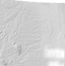
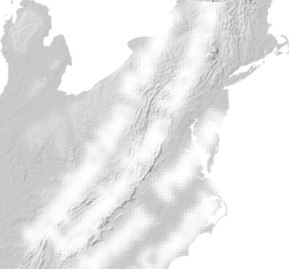
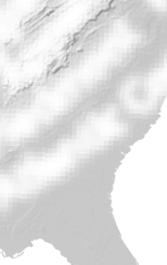
 ARE YOU READY TO THINK? Look at the first slide THINK PAIR SHARE! WHAT PROMINENT FEATURE CAN YOU IDENTIFY IN THIS PICTURE? What do you think the different colors represent? Who might find such a picture
STAAR Science Tutorial 40 TEK 8.9C: Topographic Maps & Erosional Landforms
 Name: Teacher: Pd. Date: STAAR Science Tutorial 40 TEK 8.9C: Topographic Maps & Erosional Landforms TEK 8.9C: Interpret topographic maps and satellite views to identify land and erosional features and
PALEOGEOGRAPHY of NYS. Definitions GEOLOGIC PROCESSES. Faulting. Folding 9/6/2012. TOPOGRAPHIC RELIEF MAP of NYS GRADATIONAL TECTONIC
 TOPOGRAPHIC RELIEF MAP of NYS PALEOGEOGRAPHY of NYS Prof. Anthony Grande AFG 2012 Definitions GEOLOGIC PROCESSES Geography: study of people living on the surface of the earth. Geology: the scientific study
A Living Planet. Chapter PHYSICAL GEOGRAPHY. What you will learn in this chapter. Summary of the chapter
 QUIT Main Ideas What you will learn in this chapter Summary Summary of the chapter Test your geographic knowledge by playing the. Main Ideas Section 1: The Earth Inside and Out The earth is the only habitable
Erosional Features. What processes shaped this landscape?
 Have you ever looked at the land around you and wondered what processes shaped what you see? Perhaps you see mountains, valleys, rivers, or canyons. Do you know how long these geologic features have been
Social Studies. Chapter 2 Canada s Physical Landscape
 Social Studies Chapter 2 Canada s Physical Landscape Introduction Canada s geography its landforms and climate - has a great impact on Canadians sense of identity. Planet Earth The earth is divided into
Notes and Summary pages:
 Topographic Mapping 8.9C Interpret topographical maps and satellite views to identify land and erosional features and predict how these shapes may be reshaped by weathering ATL Skills: Communication taking
Forces That Shape Earth. How do continents move? What forces can change rocks? How does plate motion affect the rock cycle?
 Forces That Shape Earth How do continents move? What forces can change rocks? How does plate motion affect the rock cycle? Plate Motion Mountain ranges are produced by plate tectonics. The theory of plate
The Marine Environment
 The Marine Environment SECTION 16.1 Shoreline Features In your textbook, read about erosional landforms, beaches, estuaries, longshore currents, and rip currents. For each statement below, write or. 1.
deep within the planet. They are also shaped by conditions on the planet s surface. In
 Chapter 4 Landforms, Water, and Natural Resources Earth is home to many different types of landforms. These landforms are shaped by forces deep within the planet. They are also shaped by conditions on
Continental Landscapes
 Continental Landscapes Landscape influenced by tectonics, climate & differential weathering Most landforms developed within the last 2 million years System moves toward an equilibrium Continental Landscapes
4th GRADE MINIMUM CONTENTS- SOCIAL SCIENCE UNIT 3: LAND RELIEF
 LAND RELIEF 4th GRADE MINIMUM CONTENTS- SOCIAL SCIENCE UNIT 3: LAND RELIEF The outer layer of the Earth is composed of rocks and minerals. It is called the lithosphere or the Earth s crust. This layer
The Continental Drift Hypothesis
 CHAPTER 7 Plate Tectonics LESSON 1 The Continental Drift Hypothesis What do you think? Read the two statements below and decide whether you agree or disagree with them. Place an A in the Before column
Social Studies 9 UNIT 2 GEOGRAPHIC INFLUENCES ON IDENTITY: PLACE AND PEOPLE
 Social Studies 9 UNIT 2 GEOGRAPHIC INFLUENCES ON IDENTITY: PLACE AND PEOPLE The Structure of the Earth To understand the forces that create Canada's physical landscape we must understand the structure
PHYSICAL GEOGRAPHY General Information
 PHYSICAL GEOGRAPHY General Information By understanding the environment we can understand why one place is different or the same as another. See handout Geomorphology Geo --Land morph --Change ology --Study
core mantle crust the center of the Earth the middle layer of the Earth made up of molten (melted) rock
 rock") core the center of the Earth mantle the middle layer of the Earth made up of molten (melted) rock crust the surface layer of the Earth that includes the continents and oceans 1 continental drift the theory
core the center of the Earth mantle the middle layer of the Earth made up of molten (melted) rock crust the surface layer of the Earth that includes the continents and oceans 1 continental drift the theory
Plate Tectonics. Chapter 17. Great Idea: The entire Earth is still changing, due to the slow convection of soft, hot rocks deep within the planet.
 Plate Tectonics Chapter 17 Great Idea: The entire Earth is still changing, due to the slow convection of soft, hot rocks deep within the planet. 1 Chapter Outline The Dynamic Earth Plate Tectonics: A Unifying
Science EOG Review: Landforms
 Mathematician Science EOG Review: Landforms Vocabulary Definition Term canyon deep, large, V- shaped valley formed by a river over millions of years of erosion; sometimes called gorges (example: Linville
netw rks Guided Reading Activity Essential Question: How does geography influence the way people live? Earth's Physical Geography
 Guided Reading Activity Lesson 1 Earth and the Sun Essential Question: How does geography influence the way people live? Looking at Earth Directions: What are the layers that make up Earth? Use your textbook
CANADA S LANDFORM REGIONS
 CANADA S LANDFORM REGIONS Canada s Regions Canada is divided into Eight major regions. A Region is an area that is defined on the basis of the presence or absence of certain characteristics: Age of rock
Changes to Land 5.7B. landforms: features on the surface of Earth such as mountains, hills, dunes, oceans and rivers
 All the landforms on Earth have changed over time and continue to change. Many of the changes were caused by wind, moving water, and moving ice. Mountains have grown and shrunk. Rivers have cut away land
Our Planet Earth. I nteractions of Earth Systems
 CHAPTER 3 LESSON 2 Our Planet Earth I nteractions of Earth Systems Key Concepts How does the water cycle show interactions of Earth systems? How does weather show interactions of Earth systems? How does
Chapter 1 Section 2. Land, Water, and Climate
 Chapter 1 Section 2 Land, Water, and Climate Vocabulary 1. Landforms- natural features of the Earth s land surface 2. Elevation- height above sea level 3. Relief- changes in height 4. Core- most inner
Physical Geography A Living Planet
 Physical Geography A Living Planet The geography and structure of the earth are continually being changed by internal forces, like plate tectonics, and external forces, like the weather. Iguaçu Falls at
Think about the landforms where you live. How do you think they have changed over time? How do you think they will change in the future?
 reflect All the landforms on Earth have changed over time and continue to change. Many of the changes were caused by wind, moving water, and moving ice. Mountains have grown and shrunk. Rivers have cut
STAAR 2013 #20; RC3; Readiness 1. Glaciers are masses of ice that move slowly on land. Which of these features was most likely formed by a glacier?
 Earth oot amp #1 5.7 Recognize how landforms such as deltas, canyons, and sand dunes are the result of changes to Earth s surface by wind, water, and ice. STR 2013 #20; R3; Readiness 1. Glaciers are masses
Exploring Geography. Chapter 1
 Exploring Geography Chapter 1 The Study of Geography Geography is the study of where people, places, and things are located and how they relate to each other. Greek meaning writing about or describing
What landforms make up Australia?!
 What landforms make up Australia? The tectonic forces of folding, faulting and volcanic activity have created many of Australia's major landforms. Other forces that work on the surface of Australia, and
Developed in Consultation with Florida Educators
 Developed in Consultation with Florida Educators Table of Contents Next Generation Sunshine State Standards Correlation Chart... 7 Benchmarks Chapter 1 The Practice of Science...................... 11
TOPOGRAPHIC RELIEF MAP of NYS. LANDFORMS of NYS. Landforms. Creation of NYS Landforms 9/22/2011
 TOPOGRAPHIC RELIEF MAP of NYS LANDFORMS of NYS Prof. Anthony Grande AFG 2011 Landforms The basis of present-day landforms (surface features) is the bedrock geology that has been worked on by the forces
The Continental Drift Hypothesis
 Lesson 1 The Continental Drift Hypothesis Scan Lesson 1. Then write three questions that you have about continental drift in your Science Journal. Try to answer your questions as you read. Pangaea Define
Constructive and Destructive Forces. Processes That Act Upon Earth s Surface Features
 Constructive and Destructive Forces Processes That Act Upon Earth s Surface Features What are Constructive and Destructive Forces? Constructive Force A constructive force is a process that raises or builds
Grade 9 Social Studies Canadian Identity. Chapter 2 Review Canada s Physical Landscape
 Grade 9 Social Studies Canadian Identity Chapter 2 Review Canada s Physical Landscape Name: Unit 1: Empowerment Terms (notes or textbook) 1. Core 2. Crust 3. Mantle 4. Magma 5. Continental drift 6. Plate
Exploring Geography. Chapter 1. Chapter 1, Section
 Chapter 1, Section World Geography Chapter 1 Exploring Geography Copyright 2003 by Pearson Education, Inc., publishing as Prentice Hall, Upper Saddle River, NJ. All rights reserved. Chapter 1, Section
Geologic Time. The Cenozoic Era. 7. Mammals evolved after dinosaurs became extinct.
 Geologic Time The Cenozoic Era Key Concepts What major geologic events occurred during the Cenozoic era? What does fossil evidence reveal about the Cenozoic era? What do you think? Read the two statements
ORLD G EOGRAPHY BASIC. NotB oring. Inventive Exercises to Sharpen Skills and Raise Achievement. Imogene Forte & Marjorie Frank
 The BASIC NotB oring SERIES SOCIAL IP 402-0 STUDIES SKILLS MIDDLE GRADES ORLD G EOGRAPHY Inventive Exercises to Sharpen Skills and Raise Achievement Series Concept & Development by Imogene Forte & Marjorie
THE EARTH S RELIEF SOCIAL SCIENCES 1º ESO
 THE EARTH S RELIEF SOCIAL SCIENCES 1º ESO 1. THE STRUCTURE OF THE EARTH The Earth is divided into layers: The crust is the surface layer. It is a thin, solid layer made of rock. The Earth s crust has a
Landforms in Canada. Canada is made up of three dis;nct types of landforms: Canadian Shield Highlands Lowlands
 Canada s Landforms What is a Landform? A landform is any physical feature of the Earth s surface having a characteris;c, recognizable shape, produced by natural causes. Landforms include major features
Movement of the Earth s Crust: Formation of: Mountain s Plateau's and Dome s
 Movement of the Earth s Crust: Formation of: Mountain s Plateau's and Dome s References Information taken from several places including Prentice Hall Earth Science: @ http://www.eram.k12.ny.us/education/components/docmgr/default.php?sectiondetaili
What is weathering and how does it change Earth s surface? Answer the question using
 7 th Grade Lesson What is weathering and how does it change Earth s surface? Answer the question using the sentence frame. You have 4 minutes. Weathering is. This changes the Earth s surface because. 1
Mapping Earth. Technology and Mapmaking
 CHAPTER 1 LESSON 2 Mapping Earth Technology and Mapmaking Key Concepts What can a topographic map tell you about the shape of Earth s surface? What can you learn from geologic maps about the rocks near
2 Georgia: Its Heritage and Its Promise
 TERMS region, erosion, fault, elevation, Fall Line, aquifer, marsh, climate, weather, precipitation, drought, tornado, hurricane, wetland, estuary, barrier island, swamp PLACES Appalachian Mountains, Appalachian
Physical Geography. Physical Geography. Physical Landscape I of the United States and Canada. Definitions. Physical Geography GEOLOGIC PROCESSES
 Physical Landscape I of the United States and Canada Physical Geography Physical landscape (natural environment) sets the stage for human use (the cultural landscape). Prof. Anthony Grande AFG 2016 Landforms
Constructive & Destructive Forces
 Monster Wrangler Mike Presents Constructive & Destructive Forces Includes: anchor charts note-taking sheets reading passages with textdependent questions 12-color card sort activity 24 vocabulary word
EQ: Discuss main geographic landforms of the U.S. & Canada and examine varied landforms in relation to their lifestyles.
 EQ: Discuss main geographic landforms of the U.S. & Canada and examine varied landforms in relation to their lifestyles. Places & Terms for Discussion Appalachian Mountains Great Plains Canadian Shield
3. [ES 3] 1. [ST8.2] Some processes that shape Earth s surface are slow. Other processes are rapid. Which statement describes a rapid change?
![3. [ES 3] 1. [ST8.2] Some processes that shape Earth s surface are slow. Other processes are rapid. Which statement describes a rapid change?](/thumbs/89/98260180.jpg "3. [ES 3] 1. [ST8.2] Some processes that shape Earth s surface are slow. Other processes are rapid. Which statement describes a rapid change?") Science 8 SCIENCE QUARTERLY ASSESSMENT 2 3. [ES 3] S 1. [ST8.2] Some processes that shape Earth s surface are slow. Other processes are rapid. Which statement describes a rapid change? A. Glaciers melt
Science 8 SCIENCE QUARTERLY ASSESSMENT 2 3. [ES 3] S 1. [ST8.2] Some processes that shape Earth s surface are slow. Other processes are rapid. Which statement describes a rapid change? A. Glaciers melt
Physical Geography. Physical Landscape I of the United States and Canada. Definitions. Physical Geography. Physical Geography GEOLOGIC PROCESSES
 Physical Landscape I of the United States and Canada Prof. Anthony Grande AFG 2017 Physical Geography Landforms and geologic processes Physical landscape (natural environment) sets the stage for human
8 th Grade Science Plate Tectonics and Topography Review
 8 th Grade Science Plate Tectonics and Topography Review #1 Scientists believe that the land masses of Earth were once joined together as one supercontinent called. A: Australia B: Wegner C: Pangaea D:
1- Water on Earth 2- Oceans and seas / continental waters 3- Uses, risks and problems of water
 Contents: I- Relief 1- Structure of the Earth and relief formation 2- Shaping of relief 3- Types of relief II- Water 1- Water on Earth 2- Oceans and seas / continental waters 3- Uses, risks and problems
LANDFORMS of NYS. Landforms. Exercise 4 9/13/2012. TOPOGRAPHIC RELIEF MAP of NYS. Physiographic map of NYS and vicinity showing Surface Features
 TOPOGRAPHIC RELIEF MAP of NYS LANDFORMS of NYS Prof. Anthony Grande AFG 2012 Landforms REMINDER: The basis of present-day landforms (surface features) is the bedrock geology that has been worked on by
Canada is a country with diverse physical features.
 Chapter 3 Landforms Canada is a country with diverse physical features. With one of the longest coastlines in the world one can discover a variety of coastal features: bays, gulf, islands, peninsulas,
TAKE HOME EXAM 8R - Geology
 Name Period Date TAKE HOME EXAM 8R - Geology PART 1 - Multiple Choice 1. A volcanic cone made up of alternating layers of lava and rock particles is a cone. a. cinder b. lava c. shield d. composite 2.
Midterm Review. Nata/Lee
 Name: 1. Which statement best supports the theory that all the continents were once a single landmass? (1) Rocks of the ocean ridges are older than those of the adjacent sea floor. (2) Rock and fossil
The structure of the Earth and how its motion creates the seasons. The landforms of the earth and the forces that shape the land.
 The structure of the Earth and how its motion creates the seasons. The landforms of the earth and the forces that shape the land. The role of wind and water in creating climate. The different climate and
Directed Reading. Section: How Mountains Form MOUNTAIN RANGES AND SYSTEMS. Skills Worksheet
 Skills Worksheet Directed Reading Section: How Mountains Form 1. How high is Mount Everest? a. about 1980 km above sea level b. more than 8 km below sea level c. more than 8 km above sea level d. more
4th Grade U.S. Regional Geography
 4th Grade U.S. Regional Geography Multiple Choice Identify the choice that best completes the statement or answers the question. What does the term mainland mean in the sentence above? A the continent
Potential short answer questions: What is Pangea? Describe at least 4 pieces of evidence that led Wegener to suggest the theory of Continental Drift.
 6th Grade Earth Science Fall Semester Mid-Term Study Guide The mid-term may include: 4 short answer questions,1-2 sketches to draw and/or label, 4 partially filled charts which you should complete, 30
Unit 7.2 W.E.D. & Topography Test
 Name: Score: Unit 7.2 W.E.D. & Topography Test 1. 2. 3. 4. 5. 6. 7. 8. 9. 10. 11. 12. 13. 14. 15. 16. 17. 18. 19. 20. 21. 22. 23. 24. 25. 1. The formation of mountains is due mainly to while the destruction
Landscape evolution. An Anthropic landscape is the landscape modified by humans for their activities and life
 Landforms Landscape evolution A Natural landscape is the original landscape that exists before it is acted upon by human culture. An Anthropic landscape is the landscape modified by humans for their activities
NEW YORK S NATURAL WONDERS
 Landscapes and Drainage Patterns NEW YORK S NATURAL WONDERS New York is not one of the largest states of the United States, nor does it have any large national parks to rival Yosemite or the Grand Canyon.
Plate Tectonics. The Theory of Plate Tectonics. The Plate Tectonics Theory. 62 Plate Tectonics Reading Essentials
 CHAPTER 4 LESSON 3 Tectonics The Theory of Tectonics Key Concepts What is the theory of plate tectonics? What are the three types of plate boundaries? Why do tectonic plates move? What do you think? Read
CHAPTER 1. Geo Challenges 1A to 1D. & World Map Activity
 CHAPTER 1 Geo Challenges 1A to 1D & World Map Activity SELECT YOUR CHALLENGE World Map Activity Challenge 1A Challenge 1B Challenge 1C Challenge 1D Challenge 1A WS PG. 2 STEP #1 Label the largest continent
Chapter 3 Erosion and Deposition. The Big Question:
 Chapter 3 Erosion and Deposition The Big Question: 1 Design a way to represent and describe the 4 types of mass movement. You may use pictures, diagrams, list, web, chart, etc 2 Chapter 3: Erosion and
Earth / Environmental Science. Ch. 14 THE OCEAN FLOOR
 Earth / Environmental Science Ch. 14 THE OCEAN FLOOR The Blue Planet Nearly 70% of the Earth s surface is covered by the global ocean It was not until the 1800s that the ocean became an important focus
Name Class Date. The ocean floor has varied and distinct surfaces much like those found on land.
 6 Explore the Seafloor BigIdeas The ocean floor has varied and distinct surfaces much like those found on land. Satellites orbiting Earth, as well as sonar technology, are used to map the seafloor. The
Chapter 1: America s Land Lesson 1: Land and Climate
 Chapter 1: America s Land Lesson 1: Land and Climate Geography: Describe landforms and other physical features of the United States. Geography: Explain how and why climate varies throughout the United
Vocabulary Words. theory continental drift fault magma lava. weathering glacier erosion deposition delta
 Earth s Landforms Vocabulary Words theory continental drift fault magma lava weathering glacier erosion deposition delta Theory: A possible explanation. Continental drift: The continuing movement of the
MARINE GEOLOGY & GEOGRAPHY
 MARINE GEOLOGY & GEOGRAPHY Bathymetry BATHYMETRY BATHYMETRY THE UNDERWATER EQUIVALENT TO TOPOGRAPHY THE STUDY OF WATER DEPTH A BATHYMETRIC MAP SHOWS FLOOR RELIEF OR TERRAIN AS CONTOUR LINES Bathymetry
Question #1: What are some ways that you think the climate may have changed in the area where you live over the past million years?
 Reading 5.2 Environmental Change Think about the area where you live. You may see changes in the landscape in that area over a year. Some of those changes are weather related. Others are due to how the
LANDFORM REGIONS IN CANADA. Classroom Notes and Descriptions
 LANDFORM REGIONS IN CANADA Classroom Notes and Descriptions Landform Regions in Canada There are eight distinct landforms in Canada: Western Cordillera Region Interior Plains Canadian Shield Hudson Bay
Copyright 2016 Edmentum - All rights reserved.
 SI Quiz 14: Wk of Nov. 28 Copyright 2016 Edmentum - All rights reserved. Question #1 Two hundred and twenty-five million years ago, all of today's continents were part of a single continent known as Pangaea.
Unit Plan. Unit Title: CHAPTER 6: Earth s Changing Surface. Essential Questions:
 Summative Assessment Objective Assessment Method (check one) Unit Plan Unit Title: CHAPTER 6: Earth s Changing Surface Essential Questions: What covers roughly 3/4s of Earth s surface? Where is inaccessible
The Sun-Earth-Moon System
 The Sun-Earth-Moon System Earth s Moon Key Concepts How does the Moon move around Earth? Why does the Moon s appearance change? What do you think? Read the two statements below and decide whether you agree