Chapter 1: The Geography of the Western Hemisphere
|
|
|
- Homer Stevenson
- 5 years ago
- Views:
Transcription
1 Chapter 1: The Geography of the Western Hemisphere
2 Chapter 1, Lesson 1: The Changing Earth
3 Objectives: - You will be able to identify the major natural events that cause the earth to change. - You will be able to locate the major geographical features of the Western Hemisphere. - You will be able to identify the three geographical regions of the Western Hemisphere.
4 NEW Vocabulary tectonics - science of the structure of Earth plate tectonics - theory that explains how the continents may rest on large plates of Earth s crust tectonic plates - pieces of Earth s structure that push, pull, and grind against each other continental drift - the theory that the seven continents slowly drifted apart
5
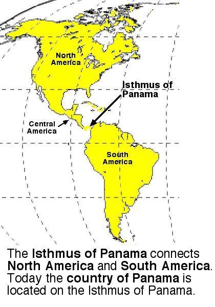
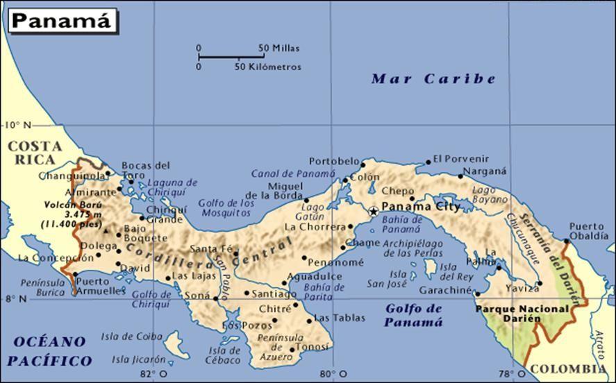
6 NEW Vocabulary region - an area with common features that set it apart from other areas isthmus - a narrow strip of land bordered by water that connects two larger areas of land (ex. Isthmus of Panama) archipelago - groups of islands geographical feature - person-made or naturally-created landforms or ecosystems of the Earth
7

8 NEW Vocabulary ecosystem - all the living things that share an environment
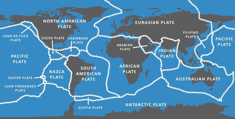
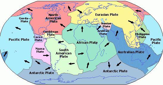
9 Plate Tectonics - Theory that explains how the continents may rest on large plates of the Earth s crust - The Earth s crust is made up of 8 large tectonic plates that move, carrying the continents and ocean floors with them (continental drift) - Many of the continents look as though they could fit together and at one time made up a supercontinent - known as Pangaea
10 Plate Tectonics - Two colliding plates mountains (when two plates push up) - Two colliding plates valleys; volcanic eruptions (when one plate goes under the other) - Two plates that move away from each other volcanic eruptions - Two grinding plates earthquake - Scientists believe the continents move at a rate of about 2 inches a year
11
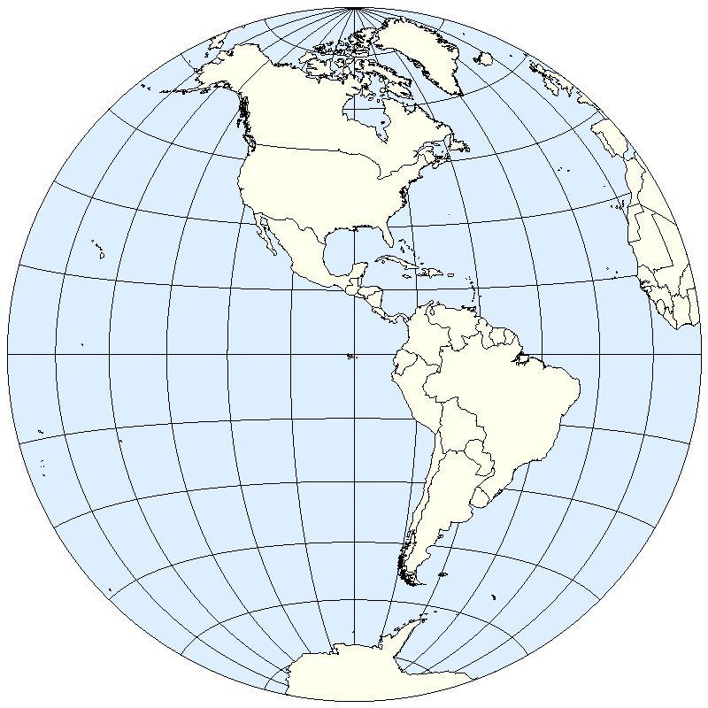
12 The Western Hemisphere Made up of three regions: 1) North America 2) Central America 3) South America

13 North America Central America South America

14 The Western Hemisphere - 90% of the land in the Western Hemisphere = North and South America - The land of the Western Hemisphere is often called the Americas
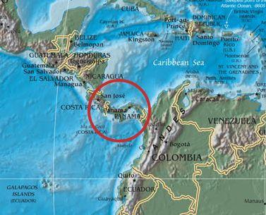
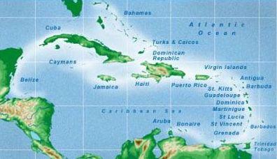
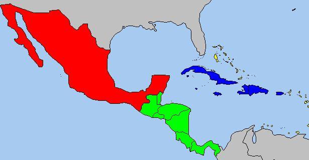
15 The Western Hemisphere - Central America - narrow piece of land that connects North and South America (considered part of North America) - Isthmus of Panama - narrowest part of Central America - Greenland - world s largest island (lies off the northeastern coast of North America) - Caribbean islands - made up of multiple archipelagos - Caribbean islands, Central America, and Mexico = Middle America
16
17
18
19
20 Chapter 1, Lesson 2: Land and Water
21 Objectives: - You will be able to describe and locate the main landforms of the Western Hemisphere. - You will be able to identify and locate the important rivers and lakes in the Western Hemisphere.
22 NEW Vocabulary tributary - a river or stream that flows into a larger body of water elevation - height above sea level landforms - a natural feature of Earth s surface that is identified based on how rugged it is and how far it is above sea level (ex. mountains, hills, plateaus, plains)


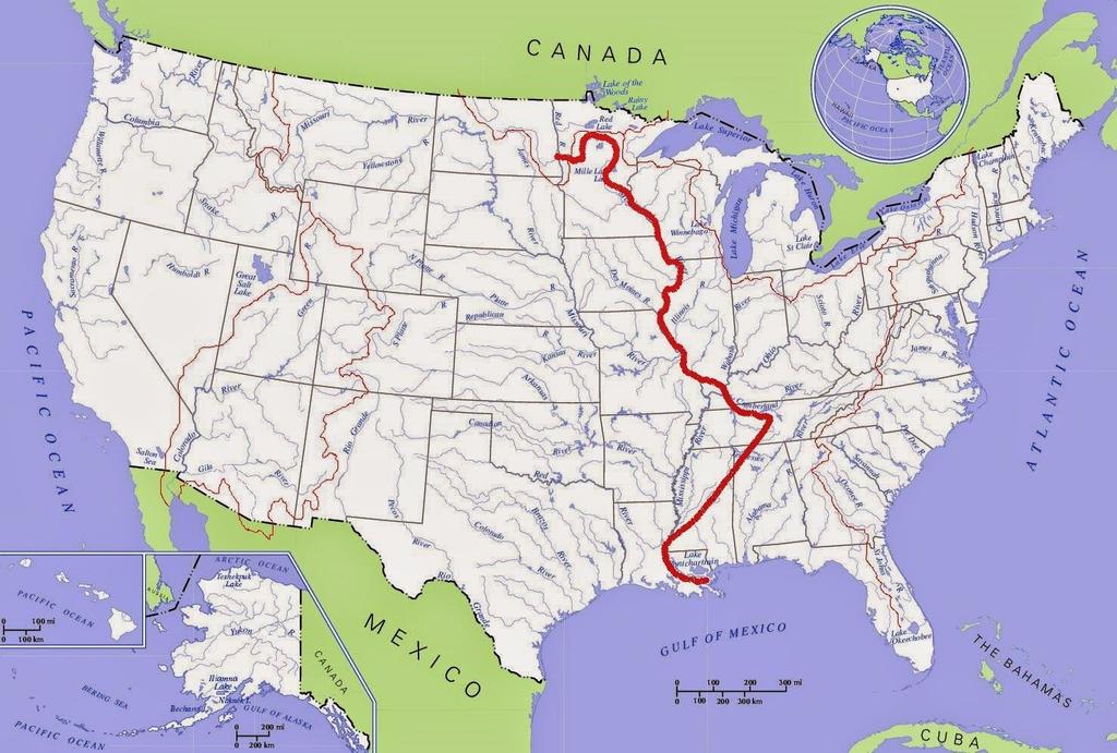
23 Bodies of water that flow into the Mississippi River
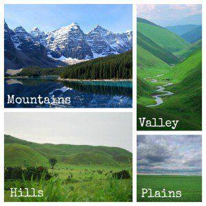
24 NEW Vocabulary mountains - a large natural elevation of the earth's surface rising abruptly from the surrounding level hills - a naturally raised area of land, not as high or rugged as a mountain plains - a large area of flat land with few trees plateaus - an area of relatively level high ground; can also be called an upland or highland
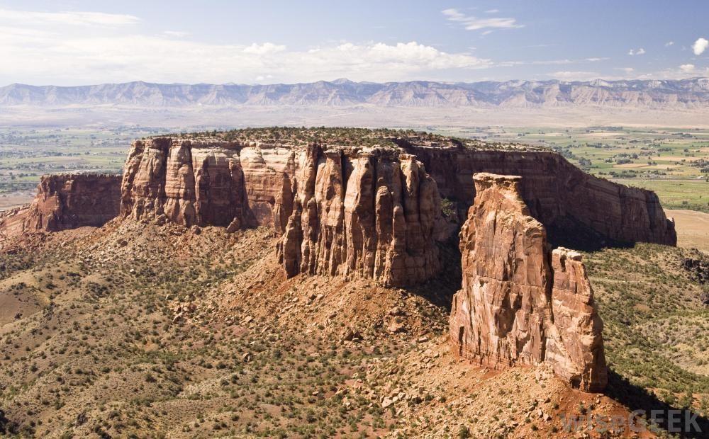
25 Plateau
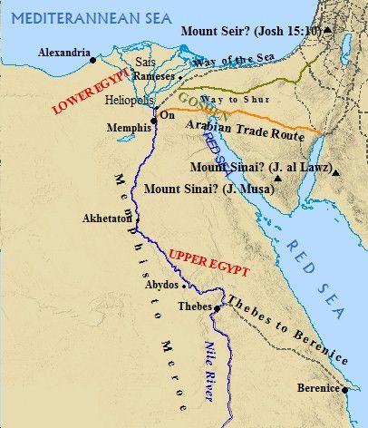
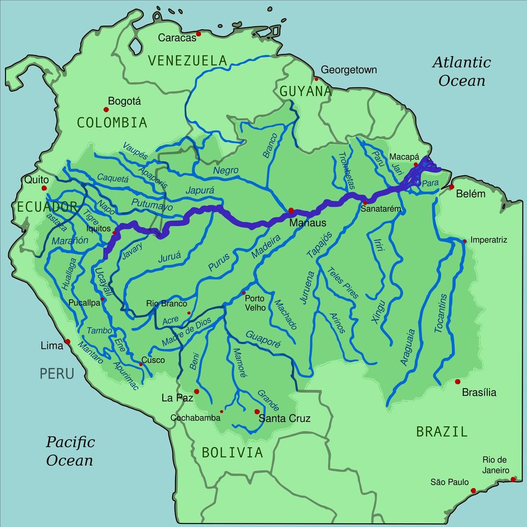
26 Great Rivers and Lakes: WH Earth s greatest rivers: 1) Nile River - longest river in the world 2) Amazon River - second longest river in the world 3) Mississippi River - longest river in North America Earth s greatest lakes: Great Lakes - five freshwater lakes located on border between Canada and United States
27
28
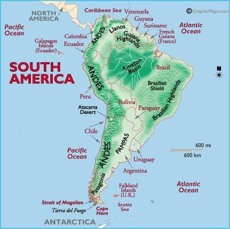
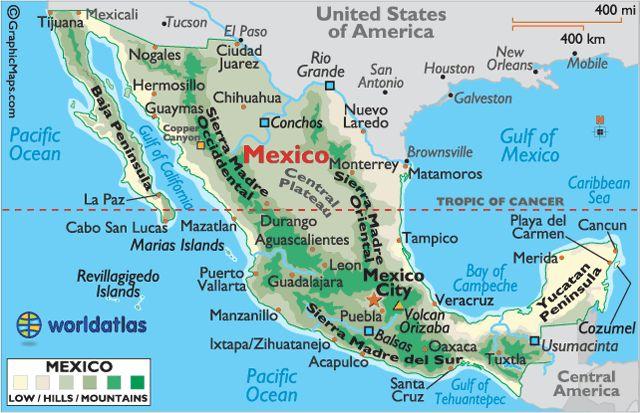
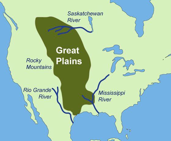
29 Landforms: WH Mountains: 1) Andes Mountains - western coast of South America 2) Mount Aconcagua - tallest mountains in the Americas 3) Rocky Mountains Plateaus: Central Mexican Plateau Plains: Great Plains - largest plain in the Americas (from northern Canada through the United States to southern Texas)
30
31
32
33
Chapter 1 Section 2. Land, Water, and Climate
 Chapter 1 Section 2 Land, Water, and Climate Vocabulary 1. Landforms- natural features of the Earth s land surface 2. Elevation- height above sea level 3. Relief- changes in height 4. Core- most inner
Vocabulary Words. theory continental drift fault magma lava. weathering glacier erosion deposition delta
 Earth s Landforms Vocabulary Words theory continental drift fault magma lava weathering glacier erosion deposition delta Theory: A possible explanation. Continental drift: The continuing movement of the
Exploring Geography. Chapter 1
 Exploring Geography Chapter 1 The Study of Geography Geography is the study of where people, places, and things are located and how they relate to each other. Greek meaning writing about or describing
Unit 1: Geography. For additional information, refer to this website: 1 G e o g r a p h y
 Unit 1: Geography For additional information, refer to this website: http://mryoungtms.weebly.com/ 1 G e o g r a p h y Continents and Oceans SOL USI. 2a Essential Understanding: Continents are large land
The structure of the Earth and how its motion creates the seasons. The landforms of the earth and the forces that shape the land.
 The structure of the Earth and how its motion creates the seasons. The landforms of the earth and the forces that shape the land. The role of wind and water in creating climate. The different climate and
Asteroids and comets.
 Asteroids and comets. Question 1 Can Asteroids and comets cause the earth to change? Asteroids do change the earth because when the earth was first starting out Asteroids and comets would come to the earth
Tectonic Forces Simulation: Earthquakes Activity One
 Tectonic Forces Simulation: Earthquakes Activity One Introduction If you marked all the earthquakes from the past century on a world map, you'd notice that most tend to occur along certain lines around
Slow and Steady By ReadWorks
 By ReadWorks How did all the amazing things on our planet form? How did magnificent mountain ranges rise up in one place and beautiful beaches form elsewhere? Why do some places experience earthquakes
Earth s Changing Continents
 2 What You Will Learn Earth s continents have moved around Earth s surface throughout Earth s history and have only recently arrived at their current locations. Rocks and fossils provide evidence of continental
What type of land feature is located at Point A? A Cliff B Delta C Mountain D Valley
 1 What type of land feature is located at Point A? A Cliff B Delta C Mountain D Valley Alfred Wegener s theory of continental drift was 2 not accepted by scientists when the theory was first proposed.
8 th Grade Science Plate Tectonics and Topography Review
 8 th Grade Science Plate Tectonics and Topography Review #1 Scientists believe that the land masses of Earth were once joined together as one supercontinent called. A: Australia B: Wegner C: Pangaea D:
Social Studies. Chapter 2 Canada s Physical Landscape
 Social Studies Chapter 2 Canada s Physical Landscape Introduction Canada s geography its landforms and climate - has a great impact on Canadians sense of identity. Planet Earth The earth is divided into
Chapter 2 Earth s Interlocking Systems pg The Earth and Its Forces pg
 Chapter 2 Earth s Interlocking Systems pg. 24 55 2 1 The Earth and Its Forces pg. 27 33 Connecting to Your World and Internal Forces Shaping the Earth The Earth is unique in the solar system because it
water erosion lithosphere Describe the process of erosion and deposition. chemical weathering Dissolving limestone is an example of.
 At one time, there was one large island off the coast of Mississippi and now it is two separate islands. What caused the island to be split into two? water erosion The crust and the top part of the upper
Unit 4 Lesson 6 Plate Tectonics
 Unit 4 Lesson 6 Plate Tectonics Indiana Standards 7.2.1 Describe how the earth is a layered structure composed of lithospheric plates, a mantle and a dense core. 7.2.4 Explain how convection currents in
deep within the planet. They are also shaped by conditions on the planet s surface. In
 Chapter 4 Landforms, Water, and Natural Resources Earth is home to many different types of landforms. These landforms are shaped by forces deep within the planet. They are also shaped by conditions on
UNIT 11 PLATE TECTONICS
 UNIT 11 PLATE TECTONICS A. ALFRED WEGENER 1. Continental drift hypothesis Single supercontinent called Pangaea 200 million years ago Pangaea (all land) began to break up and started drifting to their present
Unit 11: Plate Tectonics
 Unit 11: Plate Tectonics A. Alfred Wegner 1. Continental drift hypothesis a. single supercontinent called Pangaea b. 200 million years ago Pangaea (all land) began to break up and started drifting to their
The United States & Canada. A Regional Study of Anglo America
 A Regional Study of Anglo America Landform Regions of the United States & Canada world leaders in agricultural and industrial production because of... VAST LANDS stretch from the Atlantic Ocean on the
UNIT 2 WARM UP. List the OCEANS. Bonus: Name the Largest LAKE on Earth
 UNIT 2 WARM UP List the OCEANS Bonus: Name the Largest LAKE on Earth Land Forms Land Mountain Hill Cliff Butte Mesa Plateau Cave Volcano Desert Plains Prairie Steppe Marsh Swamp Tundra Glacier Continent
CHAPTER 1. Geo Challenges 1A to 1D. & World Map Activity
 CHAPTER 1 Geo Challenges 1A to 1D & World Map Activity SELECT YOUR CHALLENGE World Map Activity Challenge 1A Challenge 1B Challenge 1C Challenge 1D Challenge 1A WS PG. 2 STEP #1 Label the largest continent
Chapter 2 Geography. Getting to know Earth
 Chapter 2 Geography Getting to know Earth Our Solar System Sun is at the center of our solar system Contains a lot of Mass» Mass gives the Sun gravitational pull» This keeps the planets in our solar system
Earth s Layers. Earth s Surface
 CHAPTER 1 LESSON 3 Earth s Layers Earth s Surface Key Concepts What are Earth s major landforms and how do they compare? What are the major landform regions of the United States? What do you think? Read
Do Now: Vocabulary: Objectives. Vocabulary: 1/5/2016. Wegener? (Can they move?) the idea that continents have moved over time?
 the idea that continents have moved over time?") Do Now: 1. Who was Alfred Wegener? 2. What was Pangaea? 3. Are continents fixed? (Can they move?) 4. What evidence supports the idea that continents have moved over time? Objectives What evidence suggests
Do Now: 1. Who was Alfred Wegener? 2. What was Pangaea? 3. Are continents fixed? (Can they move?) 4. What evidence supports the idea that continents have moved over time? Objectives What evidence suggests
THE EARTH S RELIEF SOCIAL SCIENCES 1º ESO
 THE EARTH S RELIEF SOCIAL SCIENCES 1º ESO 1. THE STRUCTURE OF THE EARTH The Earth is divided into layers: The crust is the surface layer. It is a thin, solid layer made of rock. The Earth s crust has a
Chapter 2 Planet Earth
 Chapter 2 Planet Earth Section Notes Earth and the Sun s Energy Water on Earth The Land Close-up The Water Cycle World Almanac Major Eruptions in the Ring of Fire Quick Facts Chapter 2 Visual Summary Video
Chapter 7 Plate Tectonics. Plate tectonics accounts for important features of Earth s surface and major geologic events.
 Chapter 7 Plate Tectonics Plate tectonics accounts for important features of Earth s surface and major geologic events. 7-2 Alfred Wegener s Hypothesis of Continental Drift (1915) ONE single landmass
netw rks Guided Reading Activity Essential Question: How does geography influence the way people live? Earth's Physical Geography
 Guided Reading Activity Lesson 1 Earth and the Sun Essential Question: How does geography influence the way people live? Looking at Earth Directions: What are the layers that make up Earth? Use your textbook
Unit 1: Geography GeoTrekkers in the Western Hemisphere. Illustrated Glossary
 Unit 1: Geography GeoTrekkers in the Western Hemisphere Illustrated Glossary adapt to change in order to fit new condi/ons archipelago a group or chain of islands clustered together in a sea or ocean bodies
Plates & Boundaries The earth's continents are constantly moving due to the motions of the tectonic plates.
 Plates & Boundaries The earth's continents are constantly moving due to the motions of the tectonic plates. As you can see, some of the plates contain continents and others are mostly under the ocean.
A Living Planet. Chapter PHYSICAL GEOGRAPHY. What you will learn in this chapter. Summary of the chapter
 QUIT Main Ideas What you will learn in this chapter Summary Summary of the chapter Test your geographic knowledge by playing the. Main Ideas Section 1: The Earth Inside and Out The earth is the only habitable
1. I can describe evidence for continental drift theory (e.g., fossil evidence, mountain belts, paleoglaciation)
") Science 10 Review Earth Science Vocabulary asthenosphere continental drift theory converging plates diverging plates earthquakes epicentre fault hot spot inner core lithosphere mantle mantle convection
Science 10 Review Earth Science Vocabulary asthenosphere continental drift theory converging plates diverging plates earthquakes epicentre fault hot spot inner core lithosphere mantle mantle convection
Tuesday, September 05, 2017 Planet Earth
 Tuesday, September 05, 2017 Planet Earth Objective: Describe the solar system and Earth s location in it. Identify Earth s shape. Discuss Earth s structure. List Earth s landforms Do Now: What is a compass
What type of map is this?
 What type of map is this? This? What type of map is this? This? How about this? And this? INTERNAL FORCES THAT SHAPE THE EARTH Chp. 2 Section 3 Learning goal: Explain plate tectonics and the effects they
Physical Geography A Living Planet
 Physical Geography A Living Planet The geography and structure of the earth are continually being changed by internal forces, like plate tectonics, and external forces, like the weather. Iguaçu Falls at
Ch 9.1 Notes. Objective: Be able to explain the theory of plate tectonics and be able to explain evidence that supports it.
 Ch 9.1 Notes Objective: Be able to explain the theory of plate tectonics and be able to explain evidence that supports it. Pangaea Alfred Wegener proposed that land on Earth formed a single, huge landmass.
discussion of North America s physical features, including its landforms and bodies of
 Chapter 7 Natural Environments of North America Chapter 7 focuses on the natural environments of North America. The chapter opens with a discussion of North America s physical features, including its landforms
Outcome C&D Study Guide
 Name: Class: Outcome C&D Study Guide Identify the layers of Earth s interior Lithosphere the upper most layer of the earth that includes the crust and the hard outer mantle. It is fractured into tectonic
Plate Tectonics. How do the plates move?
 Plate Tectonics How do the plates move? Continental Drift Hypothesis In 1915, Alfred Wegener s hypothesis about Continental Drift couldn t explain the forces that could move continents. Wegener wasn t
Drifting Continents. Key Concepts
 Plate Tectonics Section Summary Key Concepts What was Alfred Wegener s hypothesis about the continents? What evidence supported Wegener s hypothesis? Why was Alfred Wegener s theory rejected by most scientists
Plate Tectonics. Chapter 8
 Plate Tectonics Chapter 8 Vocabulary Crust Mantle Core Lithosphere Continental Drift Plate Tectonics Plate Boundary Fault What Are The Earth s Layers Made Of? Atmosphere: Contains nitrogen, oxygen, carbon
1. occurs when the oceanic crust slides under the continental crust.
 1. occurs when the oceanic crust slides under the continental crust. 2. What type of stress is shown? 3. Where two plates slide past one another is called a boundary. 4. What type of stress is shown? 5.
2 Earth s Changing Continents
 CHAPTER 9 SECTION The History of Life on Earth 2 Earth s Changing Continents California Science Standards 7.4.a, 7.4.e, 7.4.f BEFORE YOU READ After you read this section, you should be able to answer these
Earth s Changing Surface
 Earth s Changing Surface Tectonics What do you think? Read the two statements below and decide whether you agree or disagree with them. Place an A in the Before column if you agree with the statement or
The Theory of Plate Tectonics
 Plate Tectonics Objectives Describe how plates move. Explain the features of plate tectonics. Describe the types of plate boundaries and the features that can form and events that can occur at each. The
Grade 9 Social Studies Canadian Identity. Chapter 2 Review Canada s Physical Landscape
 Grade 9 Social Studies Canadian Identity Chapter 2 Review Canada s Physical Landscape Name: Unit 1: Empowerment Terms (notes or textbook) 1. Core 2. Crust 3. Mantle 4. Magma 5. Continental drift 6. Plate
12. The diagram below shows the collision of an oceanic plate and a continental plate.
 Review 1. Base your answer to the following question on the cross section below, which shows the boundary between two lithospheric plates. Point X is a location in the continental lithosphere. The depth
Continental Drift. & Plate Tectonics
 Continental Drift & Plate Tectonics Alfred Wegener, a German scientist, proposed the hypothesis of CONTINENTAL DRIFT, in 1912. Hypothesis stated: All Earth s continents were once a single landmass (Pangaea)
OBJECTIVE: For each boundary type, give an example of where they occur on Earth.
 OBJECTIVE: Explain the theory of Plate Tectonics. COMPARE AND CONTRAST DIVERGENT, CONVERGENT AND TRANSFORM BOUNDARIES. ***very important. Describe what geologic features form at each of the three CONVERGENT
Social Studies 9 UNIT 2 GEOGRAPHIC INFLUENCES ON IDENTITY: PLACE AND PEOPLE
 Social Studies 9 UNIT 2 GEOGRAPHIC INFLUENCES ON IDENTITY: PLACE AND PEOPLE The Structure of the Earth To understand the forces that create Canada's physical landscape we must understand the structure
SUBSURFACE CHANGES TO EARTH. Ms. Winkle
 SUBSURFACE CHANGES TO EARTH Ms. Winkle OVERVIEW Subsurface events: occurring inside the crust and mantle Moving the lithosphere due to the convection currents in the asthenosphere Main Theories: 1912 Wegener,
Plate Tectonics CHAPTER 17
 Plate Tectonics CHAPTER 17 Layers of the Earth A. Crust- solid, 5-70 km thick Moho Two Types of Crust: Oceanic- ocean floor, more dense then because of more iron Continental-dry land (mostly silicates
Advanced World Geography Chapter 1 Exploring Geography
 Advanced World Geography Chapter 1 Exploring Geography Lesson 2 A Changing Earth In this lesson you will learn how to: describe how the earth is a changing planet that is affected by geologic processes.
2 Georgia: Its Heritage and Its Promise
 TERMS region, erosion, fault, elevation, Fall Line, aquifer, marsh, climate, weather, precipitation, drought, tornado, hurricane, wetland, estuary, barrier island, swamp PLACES Appalachian Mountains, Appalachian
WHAT IS THE EARTH MADE OF? LITHOSPHERE AND HYDROSPHERE
 UNIT 8 WHAT IS THE EARTH MADE OF? LITHOSPHERE AND HYDROSPHERE TABLE OF CONTENTS 1 THE STRUCTURE OF THE EARTH... 2 2 THE FORMATION OF THE RELIEF: INTERNAL AND EXTERNAL FORCES.... 2 2.1 Internal forces:
PLATE TECTONICS REVIEW GAME!!!!
 PLATE TECTONICS REVIEW GAME!!!! Name the four layers of the earth - crust - mantle - outer core - inner core Which part of Earth s structure contains tectonic plates? LITHOSPHERE Name one reason why the
Graham Cracker Plate Tectonics
 Graham Cracker Plate Tectonics Purpose 1. To identify and demonstrate the forces that shape the features of the Earth 2. To understand how plate boundaries interact with each other and the features created
TO GO TO ANY OF THE PAGES LISTED BELOW, CLICK ON ITS TITLE
 TO GO TO ANY OF THE PAGES LISTED BELOW, CLICK ON ITS TITLE CHAPTER 6 Plate Tectonics 1 6-1 What is continental drift? 2 6-2 Why is the seafloor spreading? 3 6-3 What evidence supports seafloor spreading?
Plate Tectonic Vocabulary Chapter 10 Pages
 Name: Period: Plate Tectonic Vocabulary Chapter 10 Pages 239-260 Vocabulary Word What is this? What are some examples? What does it look like? (draw a picture or diagram) Continental drift Mid-ocean ridge
Theory of Continental Drift
 Plate Tectonics Theory of Continental Drift Alfred Wegener suggested that continents had once been part of a supercontinent named Pangaea, that later broke up. The pieces moved apart over millions of years
Ch 17 Plate Tectonics Big Idea: Most geologic activity occurs at the boundaries between plates.
 Ch 17 Plate Tectonics Big Idea: Most geologic activity occurs at the boundaries between plates. 17.1 Drifting Continents 17.2 Seafloor Spreading 17.3 Plate Boundaries 17.4 Causes of Plate Motions Learning
Evidence for Continental Drift and The Theory of Plate Tectonics
 Evidence for Continental Drift and The Theory of Plate Tectonics Did you know that the coal that is mined in Pennsylvania was actually formed from tropical plant life near the Equator? How did it travel
I. Earth s Layers a. Crust: Earth s outside layer. Made of mostly rock. i. Continental: er; made of mostly granite, forms the continents and shallow
 I. Earth s Layers a. Crust: Earth s outside layer. Made of mostly rock. i. Continental: er; made of mostly granite, forms the continents and shallow sea beds, floats! ii. Oceanic: er; dense rock such as
Chapter 1: America s Land Lesson 1: Land and Climate
 Chapter 1: America s Land Lesson 1: Land and Climate Geography: Describe landforms and other physical features of the United States. Geography: Explain how and why climate varies throughout the United
Exploring North America
 Exploring North America Continents of the World Geography Series Author: Michael Kramme, Ph.D. Consultants: Schyrlet Cameron and Carolyn Craig Editors: Mary Dieterich and Sarah M. Anderson COPYRIGHT 2012
Physical Geography. Ariel view of the Amazon Rainforest. A Look at the Seven Continents
 Physical Geography In this unit you will learn about general physical geography. The study of the Earth s surface features provides the setting for the human-environmental interactions and for the human
A physical feature of the Earth s surface
 Earth s Landforms A physical feature of the Earth s surface A physical feature of the Earth s surface LANDFORM Highest of Earth s physical features Highest of Earth s physical features MOUNTAIN Low area
Copyright 2016 Edmentum - All rights reserved.
 SI Quiz 14: Wk of Nov. 28 Copyright 2016 Edmentum - All rights reserved. Question #1 Two hundred and twenty-five million years ago, all of today's continents were part of a single continent known as Pangaea.
Core Inner and Outer zone:
 earths layers and plate techs.notebook Core Inner and Outer zone: Outer core is liquid Inner core is solid (because of intense pressure) Iron nickel mixture Discovery of earth's core: Bill Nye 2.3 min
Section 2: How Mountains Form
 Section 2: How Mountains Form Preview Objectives Mountain Ranges and Systems Plate Tectonics and Mountains Types of Mountains Objectives Identify the types of plate collisions that form mountains. Identify
Sample Pages from. Leveled Texts for Science: Earth and Space Science
 Sample Pages from Leveled Texts for Science: Earth and Space Science The following sample pages are included in this download: Table of Contents Readability Chart Sample Passage For correlations to Common
22.4 Plate Tectonics. Africa
 The Red Sea between Africa and the Arabian peninsula in Asia marks a region where two pieces of the lithosphere are slowly moving apart. Over the next 100 million years, the Red Sea could become an ocean.
05/22/15. Tectonic plate (Noun) Plate tectonics (Noun) Oceanic crust/plate (Noun) Continental crust/plate (Noun) Continental drift (Noun)
 Plate tectonics (Noun) Oceanic crust/plate (Noun) Continental crust/plate (Noun) Continental drift (Noun)") Tectonic plate (Noun) The pieces of the Earth s crust that float on the mantle, causing continental drift and earthquakes and creating volcanoes, trenches, and mountains. The Earth s crust is divided into
Tectonic plate (Noun) The pieces of the Earth s crust that float on the mantle, causing continental drift and earthquakes and creating volcanoes, trenches, and mountains. The Earth s crust is divided into
Module 7: Plate Tectonics and Earth's Structure Topic 2 Content: Plates of the World Presentation Notes
 There are several large plates and several smaller plates that comprise the Earth s crust. How do these plates interact with the bordering plates? Review each of the world s plates and the landforms that
(version 3) I. HumAN -Environment Interaction
 I. HumAN -Environment Interaction") (version 3) I. HumAN -Environment Interaction A. Landforms 1. Earth s topography is made up of many different types of landforms. 2. While the planet is covered primarily with water, the four major types
(version 3) I. HumAN -Environment Interaction A. Landforms 1. Earth s topography is made up of many different types of landforms. 2. While the planet is covered primarily with water, the four major types
Pangaea to the Present Lesson #2
 Pangaea to the Present Lesson #2 The Earth is a dynamic or constantly changing planet. The thin, fragile plates slide very slowly on the mantle's upper layer. This sliding of the plates is caused by the
Terrain Units PALEOGEOGRAPHY: LANDFORM CREATION. Present Geology of NYS. Detailed Geologic Map of NYS
 NYS TOPOGRAPHY Why so? PALEOGEOGRAPHY: LANDFORM CREATION Prof. Anthony Grande AFG 014 Present Geology of NYS Detailed Geologic Map of NYS Generalized Geology Detailed Geology Hot links to the fold out
Refer to the map on page 173 to answer the following questions.
 Chapter 8-1 Plate Tectonics 1. Brainstorm the type of evidence that would indicate a climate change and how this evidence supports the theory of continental drift. Tropical fossils in cold regions Evidence
Looking at the world map, what do you notice about the shape of the continents? Jot down your ideas on your paper
 Looking at the world map, what do you notice about the shape of the continents? Jot down your ideas on your paper The thing is the world didn t always look like this! It used to look like this: How is
Crustal Activity. Plate Tectonics - Plates - Lithosphere - Asthenosphere - Earth s surface consists of a major plates and some minor ones
 Name: Date: Period: Tectonics The Physical Setting: Earth Science CLASS NOTES Tectonics - s - Lithosphere - Asthenosphere - Earth s surface consists of a major plates and some minor ones The plates are
Visit activities.carsondellosa.com for FREE activities!
 Grades 5 8 CD-404170 Go to carsondellosa.com for a lower-level version of every reading passage. Visit activities.carsondellosa.com for FREE activities! Table of Contents Table of Contents Introduction
Week: 4 5 Dates: 9/8 9/12 Unit: Plate Tectonics
 clementaged.weebly.com Name: ODD Period: Week: 4 5 Dates: 9/8 9/12 Unit: Plate Tectonics Monday Tuesday Wednesday Thursday Friday 7 No School 8 E 9 O *Vocabulary *Frayer Vocab *Continental Drift Notes
Forces That Shape Earth. How do continents move? What forces can change rocks? How does plate motion affect the rock cycle?
 Forces That Shape Earth How do continents move? What forces can change rocks? How does plate motion affect the rock cycle? Plate Motion Mountain ranges are produced by plate tectonics. The theory of plate
4th GRADE MINIMUM CONTENTS- SOCIAL SCIENCE UNIT 3: LAND RELIEF
 LAND RELIEF 4th GRADE MINIMUM CONTENTS- SOCIAL SCIENCE UNIT 3: LAND RELIEF The outer layer of the Earth is composed of rocks and minerals. It is called the lithosphere or the Earth s crust. This layer
Directed Reading. Section: How Mountains Form MOUNTAIN RANGES AND SYSTEMS. Skills Worksheet
 Skills Worksheet Directed Reading Section: How Mountains Form 1. How high is Mount Everest? a. about 1980 km above sea level b. more than 8 km below sea level c. more than 8 km above sea level d. more
The Theory of Continental Drift. Continental Drift Discovery
 The Theory of Continental Drift Continental Drift Discovery The World ALFRED WEGENER THEORY OF CONTINENTAL DRIFT Found evidence for PANGAEA and proposed the theory of continental drift. Continental Drift
UNIT 1 - Major Land and Water Forms
 UNIT 1 - Major Land and Water Forms Chapter 1 - Landform Patterns and Processes Topography the natural and human features of the Earth s surface. ie. Surface features elevation - the height of a particular
In the space provided, write the letter of the definition that best matches the term or phrase.
 Skills Worksheet Directed Reading Section: The Changing Continents 1. What is the result of slow movements of tectonic plates? RESHAPING EARTH S CRUST In the space provided, write the letter of the definition
Exploring Europe. Continents of the World Geography Series
 Exploring Europe Continents of the World Geography Series Author: Michael Kramme, Ph.D. Consultants: Schyrlet Cameron and Carolyn Craig Editors: Mary Dieterich and Sarah M. Anderson COPYRIGHT 2012 Mark
Inside Earth Review Packet
 1. The slow movement of the continents across the Earth s surface is defined as - A Newton s 1 st Law of Motion B Continental Drift C Law of Transformation of Energy D Earth s movement 2. The scientist
MARINE GEOLOGY & GEOGRAPHY
 MARINE GEOLOGY MARINE GEOLOGY & GEOGRAPHY Marine Geology 4 LAYERS OF THE EARTH CRUST THICKNESS: VARIES BETWEEN OCEAN & CONTINENTS 5-40 KM STATE: SOLID ELEMENTS: SILICON, ALUMINUM, CALCIUM, SODIUM, POTASSIUM
NATIONAL SPORTS SCHOOL ST BENEDICT COLLEGE
 NATIONAL SPORTS SCHOOL ST BENEDICT COLLEGE Mark HALF-YEARLY EXAMINATION 2013/14 FORM 2 GEOGRAPHY (Levels 8 7 6 5) TIME: 1h 30 min Name: Class: Answer ALL the questions. 1. TRUE or FALSE? Put a in the correct
MARINE GEOLOGY & GEOGRAPHY
 MARINE GEOLOGY & GEOGRAPHY Bathymetry BATHYMETRY BATHYMETRY THE UNDERWATER EQUIVALENT TO TOPOGRAPHY THE STUDY OF WATER DEPTH A BATHYMETRIC MAP SHOWS FLOOR RELIEF OR TERRAIN AS CONTOUR LINES Bathymetry
What is a landform? These shapes (except for bodies of water) on the earth s surface are all examples of landforms.
 on the earth s surface are all examples of landforms.") Landforms What is a landform? These shapes (except for bodies of water) on the earth s surface are all examples of landforms. archipelago a large group of many islands. The Hawaiian Islands Lighthouse
Landforms What is a landform? These shapes (except for bodies of water) on the earth s surface are all examples of landforms. archipelago a large group of many islands. The Hawaiian Islands Lighthouse
The map below shows the locations of earthquakes and volcanoes
 45 Understanding Plate Boundaries R EA D I N G The map below shows the locations of earthquakes and volcanoes on the earth s surface. Today, many of the world s most active volcanoes are located around
Prentice Hall EARTH SCIENCE
 Prentice Hall EARTH SCIENCE Tarbuck Lutgens Chapter 9 Plate Tectonics 9.1 Continental Drift An Idea Before Its Time Wegener s continental drift hypothesis stated that the continents had once been joined
Prentice Hall EARTH SCIENCE
 Prentice Hall EARTH SCIENCE Tarbuck Lutgens Chapter 9 Plate Tectonics 9.1 Continental Drift An Idea Before Its Time Wegener s continental drift hypothesis stated that the continents had once been joined
PLATE TECTONICS 11/13/ Investigations of glaciers also indicated that the land masses on Earth were once a supercontinent.
 PLATE TECTONICS Alfred Wegener thought that the landmasses fit together like a jigsaw puzzle. He called the land mass Pangaea. Meaning all land Continental Drift Wegener theory first coining the word -
The surface of the ocean floor is as varied as the land. The five major oceans, from largest to smallest, are
 11.1 Ocean Basins The surface of the ocean floor is as varied as the land. The five major oceans, from largest to smallest, are w the Pacific w the Atlantic w the Indian w the Southern w the Arctic The
Earth Structures and Processes Teacher Notes
 Aleutian Islands String of islands resulting from volcanic activity Part of the Pacific Ring of Fire Coast is very jagged and rocky with steep cliffs and mountains Underwater eruptions form new landforms