Social Studies. Chapter 2 Canada s Physical Landscape
|
|
|
- Julia Armstrong
- 5 years ago
- Views:
Transcription
1 Social Studies Chapter 2 Canada s Physical Landscape
2 Introduction Canada s geography its landforms and climate - has a great impact on Canadians sense of identity.
3 Planet Earth The earth is divided into layers Core the center It has 2 layers: a hot solid inner layer and a liquid outer core Mantle the middle layer of the earth; made up of MAGMA (melted rock). When Magma erupts from the Earth through an opening or crack it is called Lava. Crust - the solid outer layer of the earth

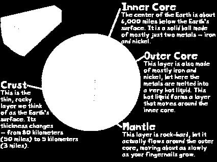
4 Planet Earth
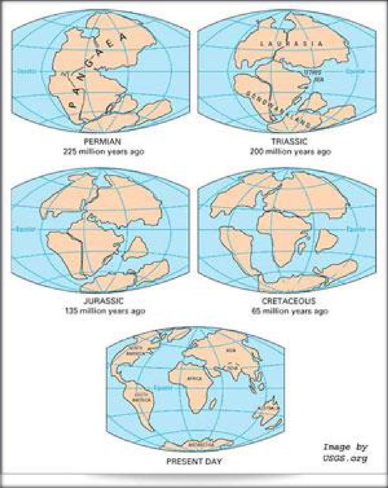
5 The Theory of Continental Drift and Plate Tectonics First suggested by the German geologist and meteorologist Alfred Wegener in The theory states that the Earth's crust is divided into plates that move slowly due to CONVECTION CURRENTS in the mantle. Wegener hypothesized that there was a gigantic supercontinent 200 million years ago, which he named Pangaea, meaning "All-earth".
6 Evidence to support Wegener s theory: the fit of the land masses presence of similar fossils in rocks separated by an ocean Matching rocks on the either side of the Atlantic
7 Continental Drift: Movement of the Earth s continents on the Earth s plates Plate Tectonics: Concept of convection currents and plate movement. The theory that plates move together to cause earthquakes, and form volcanoes and mountains.
8
9
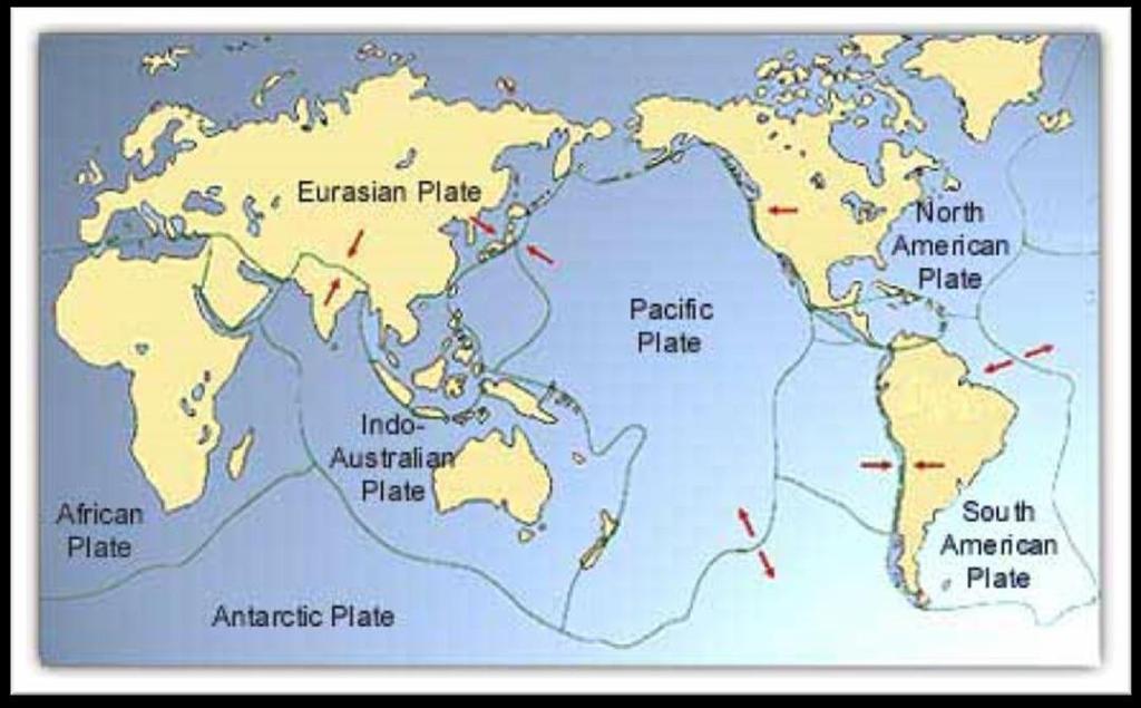
10 Canada s Crust Located on the northern part of the North American Plate Important points: Moving 2-4cm a year to the west, separating from the Eurasian plate creating a separation on the sea floor called the MID-ATLANTIC RIDGE
11 The Pacific Coast is located on the western edge of the North American Plate. The Pacific Plate moves in a northeasterly direction. This creates a SUBDUCTION ZONE an area of the earth s crust where one plate slides beneath another. This creates volcanoes and cause earthquakes to occur.
12 b_odo-q&feature=related British Columbia experiences approximately one-fifth of Canada s thousand or so earthquakes. Fault: The area where two plates meet
13 What are Landforms? Landforms are the topography, or natural features, of the land s surface. A landscape is an area s landforms together with its cover of vegetation, water, ice, and rock. Landscape also includes the activities of humans and other animals.
14 There are urban and rural landscapes. Landscapes directly affect people s lives, influencing what they eat, how they earn a living, and many other factors of daily life.
15 Topography can be described using the following terms: Elevation height of land above sea level. Relief difference in elevation between two points on the earth s surface. Gradient refers to the steepness of slopes. Geology the types of rocks and the history of those rocks. General appearance Is the description of landforms.
16 How are Landforms Built? The earth s surface is built of material that comes from beneath the crust, or it is formed by the movement of the earth s crust itself. The heat of the earth s interior creates convection currents in the mantle.

17 Important Terms Convection Currents: Movement of liquid caused by heat (ex. water bubbling as it boils)

18 Rift Valleys: formed when two plates pull apart and a valley is formed.
19 Mountains formed when two plates collide and one moves upward. Volcanic Mountains: Formed when magma moves towards the surface. It pushes up the crust but then cools and hardens as it nears the surface.
20 Plateau: a flat area between mountains. Plain: flat land under a lake or sea that is exposed when the water recedes
21 How Are Landforms Shaped? Canada s topography is the result of four forces: Mountain Building (building up force) Weathering the breakdown of rock (wearing down force)
22 Erosion wearing down due to running water, wind, waves and glaciers (wearing down force) Deposition depositing of eroded rock to make new landforms
23 Canada s Landform Regions Canada is so large that geographers divide it into regions to make it easier to study. A region is an area that is defined on the basis of the presence or absence of certain characteristics.
24 Geographers classify landform regions based on a combination of characteristics: Age of rock Type of rock Relief Gradient Process that has shaped the area
25 It is difficult to limit the number of Canadian landform regions. However, there is general agreement about the eight major regions shown in figure 2.11

26
27 Canada s Landform Regions Canadian Shield Appalachian Mountains Western Cordillera Innuitian Mountains
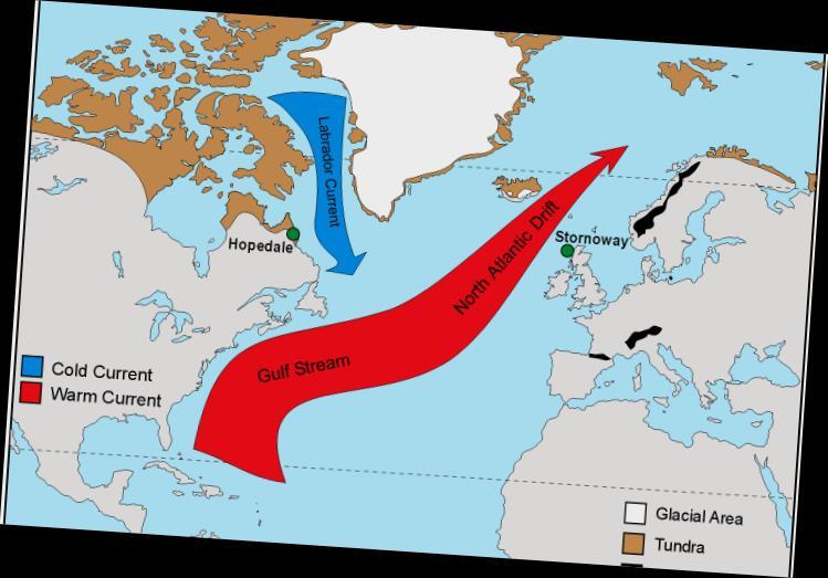
28 Arctic Lowlands Interior Plains Great Lakes-St. Lawrence Lowlands Hudson Bay Lowlands
29 Foldable Assignment Instructions for folding: given in class One panel on each landform region Include all relevant information Location Age of rock Type of rock Relief Gradient Process that has shaped the area Last panel: Map of Canada with the landform regions outline with legend.
30 Climate and Weather The other major factor of Canada s geography that affects all Canadians and their sense of identity is our climate.
31 Weather atmospheric conditions on any given day Climate patterns of weather conditions over the long term. Meteorology the science of studying weather


32 Global Factors that influence Latitude Climate As distance from the Equator increases, it gets colder due to less direct sunlight.
33 Air Masses and Wind Maritime Air forms over water and is moist Continental Air forms over land and is dry Tropical Air warm Polar Air cool Arctic Air cold These can create different types of air masses. For example Maritime Tropical (mt) air is warm and moist.
34
35 Ocean Currents can be warm or cold, making the surrounding area the same. Two currents that affect NL are: Labrador Current cold current from the north Gulf Stream Warm current from the Gulf of Mexico.
36
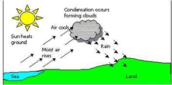
37 Precipitation Terms: Dewpoint The Temperature where condensation occurs Front: The leading edge of an air mass
38 Precipitation Three Types Frontal Convectional Relief or Orographic
39 Frontal Precipitation: When two air masses meet, the warmer one will rise over the colder one. As it rises, the air will cool and condense, causing it to rain.

40
41 Convectional Precipitation Occurs as a result of vertical movement within an air mass. Occurs over flat land on a hot summer day. The land will heat up quickly, the air will rise, cool, and precipitation will result
42
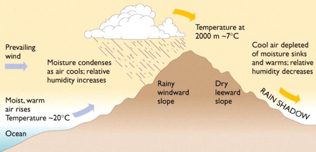
43 Relief or Orographic Precipitation Occurs when moist air moves over a mountain barrier When moist air comes in off the ocean and it has to rise over a mountain it will cool, condense and rain will occur The opposite (leyward) side of the mountain is very dry (rain shadow)
44
45 Regional Factors that affect Climate Altitude Bodies of water Mountain barriers
46 Altitude: As you go higher above sea level, the temperature decreases due to the thinning of the air
47 Closeness to Water Land heats up and cools off much faster than water. Land near the ocean will be cooler in the summer and milder in the winter. Inland locations (away from the ocean) will have cold winters and hot summers
48 Climate regions of Canada A climate region is an area that experiences similar weather conditions within its boundaries throughout a year. Developed in the early 1920 s by Wladimir Koppen, a German botanist and climatologist.
49 Koppen divided the world s climate into five types based on total annual temperatures and their precipitation, and their distribution throughout the year.
50 The Köppen system recognizes five major climatic types; each type is designated by a capital letter.
51 CLIMATE ZONE A Tropical Moist Climates: all months have average temperatures above 18 Celsius. (not found in Canada)
52 CLIMATE ZONE B Dry Climates: with deficient precipitation (evaporation and transpiration exceeds precipitation) during most of the year. Can be cool or warm
53 CLIMATE ZONE C Warm, moist climates Mild winters and warm, humid summers Parts of coastal British Columbia
54 CLIMATE ZONE D Cool, moist climates Most of Canada Wide range of average temperatures
55 Climate Zone E Polar Climates: Extremely cold winters and cool summers Very Dry
Grade 9 Social Studies Canadian Identity. Chapter 2 Review Canada s Physical Landscape
 Grade 9 Social Studies Canadian Identity Chapter 2 Review Canada s Physical Landscape Name: Unit 1: Empowerment Terms (notes or textbook) 1. Core 2. Crust 3. Mantle 4. Magma 5. Continental drift 6. Plate
01/12/2016. Introduction. Planet Earth. Plate Tectonics. Social Studies
 Introduction Social Studies Chapter 2 Canada s Physical Landscape Canada s geography its landforms and climate - has a great impact on Canadians sense of identity. Planet Earth The earth is divided into
Social Studies 9 UNIT 2 GEOGRAPHIC INFLUENCES ON IDENTITY: PLACE AND PEOPLE
 Social Studies 9 UNIT 2 GEOGRAPHIC INFLUENCES ON IDENTITY: PLACE AND PEOPLE The Structure of the Earth To understand the forces that create Canada's physical landscape we must understand the structure
Chapter 1 Section 2. Land, Water, and Climate
 Chapter 1 Section 2 Land, Water, and Climate Vocabulary 1. Landforms- natural features of the Earth s land surface 2. Elevation- height above sea level 3. Relief- changes in height 4. Core- most inner
Geology is the study of the structure and substance of the earth. The earth s physical features have been created by many geological events:
 UNIT 1 NOTES : GEOLOGY & THE EARTH S PHYSICAL STRUCTURE GEOLOGY & THE EARTH S PHYSICAL STRUCTURE Geology is the study of the structure and substance of the earth. The earth s physical features have been
Chapter 2 Planet Earth
 Chapter 2 Planet Earth Section Notes Earth and the Sun s Energy Water on Earth The Land Close-up The Water Cycle World Almanac Major Eruptions in the Ring of Fire Quick Facts Chapter 2 Visual Summary Video
Continental Drift. & Plate Tectonics
 Continental Drift & Plate Tectonics Alfred Wegener, a German scientist, proposed the hypothesis of CONTINENTAL DRIFT, in 1912. Hypothesis stated: All Earth s continents were once a single landmass (Pangaea)
Exploring Geography. Chapter 1
 Exploring Geography Chapter 1 The Study of Geography Geography is the study of where people, places, and things are located and how they relate to each other. Greek meaning writing about or describing
I. Earth s Layers a. Crust: Earth s outside layer. Made of mostly rock. i. Continental: er; made of mostly granite, forms the continents and shallow
 I. Earth s Layers a. Crust: Earth s outside layer. Made of mostly rock. i. Continental: er; made of mostly granite, forms the continents and shallow sea beds, floats! ii. Oceanic: er; dense rock such as
Chapter 2 Geography. Getting to know Earth
 Chapter 2 Geography Getting to know Earth Our Solar System Sun is at the center of our solar system Contains a lot of Mass» Mass gives the Sun gravitational pull» This keeps the planets in our solar system
THE EARTH S RELIEF SOCIAL SCIENCES 1º ESO
 THE EARTH S RELIEF SOCIAL SCIENCES 1º ESO 1. THE STRUCTURE OF THE EARTH The Earth is divided into layers: The crust is the surface layer. It is a thin, solid layer made of rock. The Earth s crust has a
Chapter 6, Part Colonizers arriving in North America found extremely landscapes. It looked different to region showing great.
 Social Studies 9 Unit 1 Worksheet Chapter 6, Part 1. 1. Colonizers arriving in North America found extremely landscapes. It looked different to region showing great. 2. The Earth is years old and is composed
Chapter 2: Physical Geography
 Chapter 2: Physical Geography Pg. 39-68 Learning Goals for Chp2: q q q q q Explain how the Earth moves in space and why seasons change. Outline the factors that influence climate and recognize different
Grade 9 Geography Chapter 11 - Climate Connections
 Grade 9 Geography Chapter 11 - Climate Connections 1. Define: Weather. 2. In what way has weather affected your activities in the last two weeks? 3. Define: Climate. 4. Canada s climate is a function of
Name Date Class. How have geologists learned about Earth s inner structure? What are the characteristics of Earth s crust, mantle, and core?
 Chapter 4 Plate Tectonics Section 1 Summary Earth s Interior How have geologists learned about Earth s inner structure? What are the characteristics of Earth s crust, mantle, and core? Earth s surface
8 th Grade Science Plate Tectonics and Topography Review
 8 th Grade Science Plate Tectonics and Topography Review #1 Scientists believe that the land masses of Earth were once joined together as one supercontinent called. A: Australia B: Wegner C: Pangaea D:
Grade 7 Science Unit 4: The Earth s Crust PLATE TECTONIC THEORY
 Grade 7 Science Unit 4: The Earth s Crust PLATE TECTONIC THEORY Alfred Wegener 1880 1930 German meteorologist He noticed that the continents fit together like a puzzle. He said that at one time all continents
Directed Reading. Section: The Theory of Plate Tectonics. to the development of plate tectonics, developed? HOW CONTINENTS MOVE
 Skills Worksheet Directed Reading Section: The Theory of Plate Tectonics 1. The theory that explains why and how continents move is called. 2. By what time period was evidence supporting continental drift,
What type of land feature is located at Point A? A Cliff B Delta C Mountain D Valley
 1 What type of land feature is located at Point A? A Cliff B Delta C Mountain D Valley Alfred Wegener s theory of continental drift was 2 not accepted by scientists when the theory was first proposed.
sonar seismic wave basalt granite
 geologist sonar crust geology seismic wave mantle constructive force basalt inner core destructive force granite outer core The solid, rocky, surface layer of the earth. an instrument that can find objects
In order to study Plate Tectonics, we must first
 TB Chapter 13 In order to study Plate Tectonics, we must first reorganize our layering system for the Earth: Old System 4 layers Crust (rigid) id) (rigid) Mantle (putty like) (semi rigid) Outer core (liquid)
CANADA S LANDFORM REGIONS
 CANADA S LANDFORM REGIONS Canada s Regions Canada is divided into Eight major regions. A Region is an area that is defined on the basis of the presence or absence of certain characteristics: Age of rock
PLATE TECTONICS REVIEW GAME!!!!
 PLATE TECTONICS REVIEW GAME!!!! Name the four layers of the earth - crust - mantle - outer core - inner core Which part of Earth s structure contains tectonic plates? LITHOSPHERE Name one reason why the
deep within the planet. They are also shaped by conditions on the planet s surface. In
 Chapter 4 Landforms, Water, and Natural Resources Earth is home to many different types of landforms. These landforms are shaped by forces deep within the planet. They are also shaped by conditions on
1. I can describe evidence for continental drift theory (e.g., fossil evidence, mountain belts, paleoglaciation)
") Science 10 Review Earth Science Vocabulary asthenosphere continental drift theory converging plates diverging plates earthquakes epicentre fault hot spot inner core lithosphere mantle mantle convection
Science 10 Review Earth Science Vocabulary asthenosphere continental drift theory converging plates diverging plates earthquakes epicentre fault hot spot inner core lithosphere mantle mantle convection
A physical feature of the Earth s surface
 Earth s Landforms A physical feature of the Earth s surface A physical feature of the Earth s surface LANDFORM Highest of Earth s physical features Highest of Earth s physical features MOUNTAIN Low area
UNIT 11 PLATE TECTONICS
 UNIT 11 PLATE TECTONICS A. ALFRED WEGENER 1. Continental drift hypothesis Single supercontinent called Pangaea 200 million years ago Pangaea (all land) began to break up and started drifting to their present
Science 10 PROVINCIAL EXAM STUDY BOOKLET. Unit 4. Earth Science
 Science 10 PROVNCAL EXAM STUDY BOOKLET Unit 4 Earth Science Student nstructions 1. Ensure that you have blank paper and a Data Booklet. 2. Record all answers on a separate piece of paper. 3. Answer keys
8 th Grade Campus Assessment- NSMS Plate Tectonics
 1. A group of students were discussing plate tectonics in their science class. All of the following statements about the tectonic plates are incorrect EXCEPT: A. The Eurasian Plate consists of the Asian
Section 1: Earth s Interior and Plate Tectonics Section 2: Earthquakes and Volcanoes Section 3: Minerals and Rocks Section 4: Weathering and Erosion
 Section 1: Earth s Interior and Plate Tectonics Section 2: Earthquakes and Volcanoes Section 3: Minerals and Rocks Section 4: Weathering and Erosion Key Terms Crust Mantle Core Lithosphere Plate Tectonics
TAKE HOME EXAM 8R - Geology
 Name Period Date TAKE HOME EXAM 8R - Geology PART 1 - Multiple Choice 1. A volcanic cone made up of alternating layers of lava and rock particles is a cone. a. cinder b. lava c. shield d. composite 2.
Name Date Class Benchmark 3 Science Study Guide. Weather & Geology
 Benchmark 3 Science Study Guide Weather & Geology S6E5 A-Crust, Mantle, Core 1. What happens to the temperature as you travel to the center of the Earth? Temperature increases with depth 2. What happens
UNIT 1 - Major Land and Water Forms
 UNIT 1 - Major Land and Water Forms Chapter 1 - Landform Patterns and Processes Topography the natural and human features of the Earth s surface. ie. Surface features elevation - the height of a particular
Plate Tectonics. Chapter 8
 Plate Tectonics Chapter 8 Vocabulary Crust Mantle Core Lithosphere Continental Drift Plate Tectonics Plate Boundary Fault What Are The Earth s Layers Made Of? Atmosphere: Contains nitrogen, oxygen, carbon
water erosion lithosphere Describe the process of erosion and deposition. chemical weathering Dissolving limestone is an example of.
 At one time, there was one large island off the coast of Mississippi and now it is two separate islands. What caused the island to be split into two? water erosion The crust and the top part of the upper
Refer to the map on page 173 to answer the following questions.
 Chapter 8-1 Plate Tectonics 1. Brainstorm the type of evidence that would indicate a climate change and how this evidence supports the theory of continental drift. Tropical fossils in cold regions Evidence
1 Earth s Oceans. TAKE A LOOK 2. Identify What are the five main oceans?
 CHAPTER 13 1 Earth s Oceans SECTION Exploring the Oceans BEFORE YOU READ After you read this section, you should be able to answer these questions: What affects the salinity of ocean water? What affects
22.4 Plate Tectonics. Africa
 The Red Sea between Africa and the Arabian peninsula in Asia marks a region where two pieces of the lithosphere are slowly moving apart. Over the next 100 million years, the Red Sea could become an ocean.
Exploring Inside the Earth
 Plate Tectonics Exploring Inside the Earth Geologists have used evidence from rock samples and evidence from seismic waves to learn about Earth s interior. Geologists are scientists who study the forces
Plate Tectonics CHAPTER 17
 Plate Tectonics CHAPTER 17 Layers of the Earth A. Crust- solid, 5-70 km thick Moho Two Types of Crust: Oceanic- ocean floor, more dense then because of more iron Continental-dry land (mostly silicates
Physical Geography A Living Planet
 Physical Geography A Living Planet The geography and structure of the earth are continually being changed by internal forces, like plate tectonics, and external forces, like the weather. Iguaçu Falls at
Vocabulary Words. theory continental drift fault magma lava. weathering glacier erosion deposition delta
 Earth s Landforms Vocabulary Words theory continental drift fault magma lava weathering glacier erosion deposition delta Theory: A possible explanation. Continental drift: The continuing movement of the
TO GO TO ANY OF THE PAGES LISTED BELOW, CLICK ON ITS TITLE
 TO GO TO ANY OF THE PAGES LISTED BELOW, CLICK ON ITS TITLE CHAPTER 6 Plate Tectonics 1 6-1 What is continental drift? 2 6-2 Why is the seafloor spreading? 3 6-3 What evidence supports seafloor spreading?
Tuesday, September 05, 2017 Planet Earth
 Tuesday, September 05, 2017 Planet Earth Objective: Describe the solar system and Earth s location in it. Identify Earth s shape. Discuss Earth s structure. List Earth s landforms Do Now: What is a compass
A Living Planet. Chapter PHYSICAL GEOGRAPHY. What you will learn in this chapter. Summary of the chapter
 QUIT Main Ideas What you will learn in this chapter Summary Summary of the chapter Test your geographic knowledge by playing the. Main Ideas Section 1: The Earth Inside and Out The earth is the only habitable
Ch 9.1 Notes. Objective: Be able to explain the theory of plate tectonics and be able to explain evidence that supports it.
 Ch 9.1 Notes Objective: Be able to explain the theory of plate tectonics and be able to explain evidence that supports it. Pangaea Alfred Wegener proposed that land on Earth formed a single, huge landmass.
Outcome C&D Study Guide
 Name: Class: Outcome C&D Study Guide Identify the layers of Earth s interior Lithosphere the upper most layer of the earth that includes the crust and the hard outer mantle. It is fractured into tectonic
Plate Tectonics. Continental Drift Sea Floor Spreading Plate Boundaries
 Plate Tectonics Continental Drift Sea Floor Spreading Plate Boundaries Continental Drift 1915, Alfred Wegener - Pangea hypothesis: suggested Earth s continents were part of a large super-continent 200
Unit Topics. Topic 1: Earth s Interior Topic 2: Continental Drift Topic 3: Crustal Activity Topic 4: Crustal Boundaries Topic 5: Earthquakes
 The Dynamic Earth Unit Topics Topic 1: Earth s Interior Topic 2: Continental Drift Topic 3: Crustal Activity Topic 4: Crustal Boundaries Topic 5: Earthquakes Topic 1: Earth s Interior Essential Question:
UNIT 3 GEOLOGY VOCABULARY FLASHCARDS THESE KEY VOCABULARY WORDS AND PHRASES APPEAR ON THE UNIT 3 CBA
 UNIT 3 GEOLOGY VOCABULARY FLASHCARDS THESE KEY VOCABULARY WORDS AND PHRASES APPEAR ON THE UNIT 3 CBA A map that shows Earth s Topographic Map surface topography, which is Earth s shape and features Contour
Unit 11: Plate Tectonics
 Unit 11: Plate Tectonics A. Alfred Wegner 1. Continental drift hypothesis a. single supercontinent called Pangaea b. 200 million years ago Pangaea (all land) began to break up and started drifting to their
Exploring Geography. Chapter 1. Chapter 1, Section
 Chapter 1, Section World Geography Chapter 1 Exploring Geography Copyright 2003 by Pearson Education, Inc., publishing as Prentice Hall, Upper Saddle River, NJ. All rights reserved. Chapter 1, Section
Objective 3: Earth and Space Systems
 Name Class Period: Objective 3: Earth and Space Systems 1. The diagram above shows the orbit of the moon around Earth. At which point in the moon s orbit will a person standing on Earth see a waxing crescent
Plate Tectonic Vocabulary Chapter 10 Pages
 Name: Period: Plate Tectonic Vocabulary Chapter 10 Pages 239-260 Vocabulary Word What is this? What are some examples? What does it look like? (draw a picture or diagram) Continental drift Mid-ocean ridge
5. Convergent boundaries produce a relatively low number of earthquakes compared to other boundaries. a. True
 1. Earth s crust is thinner than its mantle. ANSWER: True 2. The concept of isostacy states that high-density rock will stand higher than low-density rock, which explains the formation of subduction zones.
Directed Reading. Section: Continental Drift. years ago? WEGENER S HYPOTHESIS
 Skills Worksheet Directed Reading Section: Continental Drift 1. Who obtained new information about the continents and their coastlines 400 years ago? 2. What did people notice when they studied new world
Chapter 2 Earth s Interlocking Systems pg The Earth and Its Forces pg
 Chapter 2 Earth s Interlocking Systems pg. 24 55 2 1 The Earth and Its Forces pg. 27 33 Connecting to Your World and Internal Forces Shaping the Earth The Earth is unique in the solar system because it
Benchmark #: State Language: Student Friendly Language: The student models earth s cycles, constructive and
 Science, Grade: 7 Mastery Check Benchmark #: 7.4.1.2 4 State Language: Student Friendly Language: The student models earth s cycles, constructive and I will be able to describe weathering, erosion, and
Section 1: How Did Life Begin? Chapter 19: History of Life on Earth. Section 2: The Age of Earth
 Chapter 19: History of Life on Earth Section 1: How Did Life Begin? I. The Basic Chemicals of Life A. 1920s B. Earth s early oceans contained large amounts of organic molecules C. Molecules formed spontaneously
Plate Tectonics Practice Test
 Plate Tectonics Practice Test 1. What is the main idea Alfred Wegner proposed in the Theory of Continental Drift that he published in 1915? a. The continents float on a liquid layer that allows them to
netw rks Guided Reading Activity Essential Question: How does geography influence the way people live? Earth's Physical Geography
 Guided Reading Activity Lesson 1 Earth and the Sun Essential Question: How does geography influence the way people live? Looking at Earth Directions: What are the layers that make up Earth? Use your textbook
Earth s Changing Surface
 Earth s Changing Surface Tectonics What do you think? Read the two statements below and decide whether you agree or disagree with them. Place an A in the Before column if you agree with the statement or
Plate Tectonic Review, Types of Plates
 Plate Tectonic Review, Types of Plates Review from last week: 1. Alfred Wegener: thought that sections of the Earth s crust moved, but people were confused, and thought that continents drifted over water
Plate Tectonics. 8 th grade
 Plate Tectonics 8 th grade Not in notes- look at picture If you look at a map of Earth s surface, you can see that the edges of some continents look as though they could fit together like a puzzle Wegener
Terrain Units PALEOGEOGRAPHY: LANDFORM CREATION. Present Geology of NYS. Detailed Geologic Map of NYS
 NYS TOPOGRAPHY Why so? PALEOGEOGRAPHY: LANDFORM CREATION Prof. Anthony Grande AFG 014 Present Geology of NYS Detailed Geologic Map of NYS Generalized Geology Detailed Geology Hot links to the fold out
WHAT IS THE EARTH MADE OF? LITHOSPHERE AND HYDROSPHERE
 UNIT 8 WHAT IS THE EARTH MADE OF? LITHOSPHERE AND HYDROSPHERE TABLE OF CONTENTS 1 THE STRUCTURE OF THE EARTH... 2 2 THE FORMATION OF THE RELIEF: INTERNAL AND EXTERNAL FORCES.... 2 2.1 Internal forces:
CLIMATE. UNIT TWO March 2019
 CLIMATE UNIT TWO March 2019 OUTCOME 9.2.1Demonstrate an understanding of the basic features of Canada s landscape and climate. identify and locate major climatic regions of Canada explain the characteristics
Topic 5: The Dynamic Crust (workbook p ) Evidence that Earth s crust has shifted and changed in both the past and the present is shown by:
 Evidence that Earth s crust has shifted and changed in both the past and the present is shown by:") Topic 5: The Dynamic Crust (workbook p. 65-85) Evidence that Earth s crust has shifted and changed in both the past and the present is shown by: --sedimentary horizontal rock layers (strata) are found
Topic 5: The Dynamic Crust (workbook p. 65-85) Evidence that Earth s crust has shifted and changed in both the past and the present is shown by: --sedimentary horizontal rock layers (strata) are found
Name Date Class. Plate Tectonics
 Chapter Review Plate Tectonics Part A. Vocabulary Review Directions: Write the term that matches each description below in the spaces provided. Then unscramble the letters in the boxes to reveal the mystery
Ch. 9 Review. Pgs #1-31 Write Questions and Answers
 Ch. 9 Review Pgs. 356-357 #1-31 Write Questions and Answers 356-357 #1-5 Answers 1. The layer of the upper mantle that can flow is the: A - Asthenosphere 2. Most scientists rejected Wegener s theory of
World Geography 3202 Unit 1. Ch. 1: Landform Patterns and Processes
 World Geography 3202 Unit 1 Ch. 1: Landform Patterns and Processes - Planet Earth is dynamic - behaves as if it s a living organism - some changes are rapid enough for us to see and record - exs. Tidal
PLATE TECTONICS. SECTION 17.1 Drifting Continents
 Date Period Name PLATE TECTONICS SECTION.1 Drifting Continents In your textbook, read about continental drift. Circle the letter of the choice that best completes each statement. 1. Early mapmakers thought
1. occurs when the oceanic crust slides under the continental crust.
 1. occurs when the oceanic crust slides under the continental crust. 2. What type of stress is shown? 3. Where two plates slide past one another is called a boundary. 4. What type of stress is shown? 5.
GRADE 7 SCIENCE UNIT 4: THE EARTH S CRUST. 11/12 Earth s Crust is constantly changing Weathering and Erosion
 GRADE 7 SCIENCE UNIT 4: THE EARTH S CRUST 11/12 Earth s Crust is constantly changing Weathering and Erosion Earth s Structure - Layers of the Earth Draw a labeled Diagram Layers of the Earth Rap s https://www.youtube.com/watch?v=q9j1xgaxyzy
Moving Plates: Restless Earth
 Name Date Moving Plates: Restless Earth 1-9 Read the paragraphs and write the word that completes the sentence correctly. fossils mantle continent supercontinent plates motion ontinental Drift Plate Tectonics
Name: Answer Key Date: Period:
 Name: Answer Key Date: Period: Earth Science Final Exam Study Guide Ch 1: Mapping 1. On the global grid, the equator is at 0 degrees. Is the equator a line of longitude or latitude? Latitude 2. What type
The surface of the ocean floor is as varied as the land. The five major oceans, from largest to smallest, are
 11.1 Ocean Basins The surface of the ocean floor is as varied as the land. The five major oceans, from largest to smallest, are w the Pacific w the Atlantic w the Indian w the Southern w the Arctic The
Ch 17 Plate Tectonics Big Idea: Most geologic activity occurs at the boundaries between plates.
 Ch 17 Plate Tectonics Big Idea: Most geologic activity occurs at the boundaries between plates. 17.1 Drifting Continents 17.2 Seafloor Spreading 17.3 Plate Boundaries 17.4 Causes of Plate Motions Learning
Topography the natural and human features of the Earth s surface. ie. Surface features need to understand difference between relief and elevation
 Chapter 1 Landform Patterns and Processes Highlighted script will not be assessed Topography the natural and human features of the Earth s surface. ie. Surface features need to understand difference between
Earth Systems, Structures and Processes
 Earth Systems, Structures and Processes Date: 6.E.2 Understand the structure of the earth and how interactions of constructive and destructive forces have resulted in changes in the surface of the Earth
Beneath our Feet: The 4 Layers of the Earty by Kelly Hashway
 Beneath our Feet: The 4 Layers of the Earty by Kelly Hashway The Earth is more than a giant ball made up of dirt, rocks, and minerals. The Earth may look like a giant ball from when looking at it from
Prentice Hall EARTH SCIENCE
 Prentice Hall EARTH SCIENCE Tarbuck Lutgens Chapter 21 Climate 21.1 Factors That Affect Climate Factors That Affect Climate Latitude As latitude increases, the intensity of solar energy decreases. The
Section 1: Continental Drift
 Plate Tectonics Section 1 Section 1: Continental Drift Preview Key Ideas Wegener s Hypothesis Sea-Floor Spreading Paleomagnetism Wegener Redeemed Continental Drift (Pangaea) Plate Tectonics Section 1 Key
Name Period Date 8R MIDTERM REVIEW I. ASTRONOMY 1. Most stars are made mostly of. 2. The dark, cooler areas on the sun s surface are
 Name Period Date 8R MIDTERM REVIEW I. ASTRONOMY 1. Most stars are made mostly of 2. The dark, cooler areas on the sun s surface are 3. When hydrogen nuclei fuse they form 4. Einstein s equation is 5. The
Unit 4 - Water. Earth s Interior. Earth s Interior. Continental Drift. Continental Drift. Continental Drift. Crust. Mantle. Core.
 Unit 4 - Water How did the oceans form? What special adaptations do saltwater organisms have? Where does our water come from? How do humans affect the Earth s water? Crust Rigid outer shell of Earth Oceanic
CONTINENTAL DRIFT THEORY
 CONTINENTAL DRIFT THEORY Proof or crazy idea? CONTINENTAL DRIFT THEORY What is Continental Drift Theory? Continental drift theory (CDT): Alfred Wegener found all the continents were once together called
Climates of Earth. Lesson Outline LESSON 1. A. What is climate? 1. is the long-term average weather conditions that occur in a particular region.
 Lesson Outline LESSON 1 A. What is climate? 1. is the long-term average weather conditions that occur in a particular region. 2. Climate depends on how average weather conditions throughout the year. B.
Unit 10 ~ Learning Guide
 Unit 10 ~ Learning Guide Name: INSTRUCTIONS Using a pencil, complete the following practice questions as you work through the related lessons. You are required to have this package completed BEFORE you
OBJECTIVE: For each boundary type, give an example of where they occur on Earth.
 OBJECTIVE: Explain the theory of Plate Tectonics. COMPARE AND CONTRAST DIVERGENT, CONVERGENT AND TRANSFORM BOUNDARIES. ***very important. Describe what geologic features form at each of the three CONVERGENT
Geologists are scientists who study Earth. They want to
 What Is Inside Earth? Figure 1 Over time, the Grand Canyon in Arizona was carved out by the flowing water of the Colorado River. We can see that Earth s surface is constantly changing. But what is happening
Unit 4 Lesson 6 Plate Tectonics
 Unit 4 Lesson 6 Plate Tectonics Indiana Standards 7.2.1 Describe how the earth is a layered structure composed of lithospheric plates, a mantle and a dense core. 7.2.4 Explain how convection currents in
Markville. CGC 1DL/PL Geography. Geography of Canada. Natural Environment Unit Test
 Markville CGC 1DL/PL Geography Geography of Canada Natural Environment Unit Test Name: Thinking /10 Knowledge /10 Application /10 Communication /10 Part A: Blanks (1 mark each) Thinking Choose the correct
Unit 4 Lesson 2 Plate Tectonics. Copyright Houghton Mifflin Harcourt Publishing Company
 Puzzling Evidence What evidence suggests that continents move? In the late 1800s, Alfred Wegener proposed his hypothesis of continental drift. According to this hypothesis, the continents once formed a
Plate Boundaries & Resulting Landforms
 Plate Boundaries & Resulting Landforms Divergent Plate Boundaries (plates being pulled apart) Type: oceanic plates Description: rising magma gently lifts the crust creating a ridge. The flow of convection
Earth s Changing Continents
 2 What You Will Learn Earth s continents have moved around Earth s surface throughout Earth s history and have only recently arrived at their current locations. Rocks and fossils provide evidence of continental
Chapter 7 Plate Tectonics. Plate tectonics accounts for important features of Earth s surface and major geologic events.
 Chapter 7 Plate Tectonics Plate tectonics accounts for important features of Earth s surface and major geologic events. 7-2 Alfred Wegener s Hypothesis of Continental Drift (1915) ONE single landmass
PLATE TECTONICS Chapter 4 Notes
 PLATE TECTONICS Chapter 4 Notes Review Earth s Interior Ch 1. Geologists have used two main types of evidence to learn about Earth s interior: Direct evidence from rocks drilled from deep inside Earth
Climates are described by the same conditions used to describe
 58 The Causes of Climate R EA D I N G Climates are described by the same conditions used to describe weather, such as temperature, precipitation, and wind. You now know that oceans have an important effect
UNIT 1: WATER SYSTEMS ON EARTH CHAPTER 2: OCEANS CONTROL THE WATER CYCLE
 UNIT 1: WATER SYSTEMS ON EARTH CHAPTER 2: OCEANS CONTROL THE WATER CYCLE ORIGINS OF OCEAN WATER OCEANS HAVE FILLED OVER HUNDREDS OF MILLIONS OF YEARS SCIENTISTS BELIEVE THE OCEANS ARE MORE THAN 3 BILLION
Plate Tectonics. Earth has distinctive layers - Like an onion
 Plate Tectonics Earth has distinctive layers - Like an onion Earth s Interior Core: Metallic (Iron, Nickel) Inner (hot, solid, dense, Iron, Nickel) Outer (cooler, liquid, less dense) Crust (outermost layer):