Social Studies 9 UNIT 2 GEOGRAPHIC INFLUENCES ON IDENTITY: PLACE AND PEOPLE
|
|
|
- Ferdinand Taylor
- 5 years ago
- Views:
Transcription
1 Social Studies 9 UNIT 2 GEOGRAPHIC INFLUENCES ON IDENTITY: PLACE AND PEOPLE


2 The Structure of the Earth To understand the forces that create Canada's physical landscape we must understand the structure of the earth. The earth is made up of four layers
3 The Four Layers of the Earth Inner Core: Solid and hot because it is under a lot of pressure. Outer Core: Liquid material that surrounds the inner core. Mantle: A liquid and semi liquid layer that exists between the outer core and crust the upper part is known as the asthenosphere, this section is involved in plate tectonics. Crust (Lithosphere): A solid but brittle outer layer of the planet Video: Structure of Earth
4 The Theory of Continental Drift A theory suggested by German geologist Alfred Wagner in 1915 He examined the shape of the continents, rock structures, and recovered fossils to come up with his theory. He proposed that the Earth s crust is not solid but made up of plates moving upon the mantle. He believed there was once a super continent called Pangea and one sea called Panthalassa Video: Continental Drift

5 Plate Tectonics Plate Tectonics: The theory that the earth s plates interact to produce mountains, trenches, earthquakes, and volcanoes. The moving of the earths plates causes the following: Earthquakes Volcanos Mountains Tsunamis Video: Plate Tectonics
6 Tectonics and Canada Canada is on the North American Plate It moves West away from Europe at 2-4 cm per year Mid Atlantic Ridge: Area of the Atlantic Ocean where the sea floor is expanding. Off the west coast of Canada there is a subduction zone. Subduction Zone: Area where one plate is pulled down beneath another creating volcanoes and earthquakes Video: Mid Atlantic Ridge Video: Subduction Zone

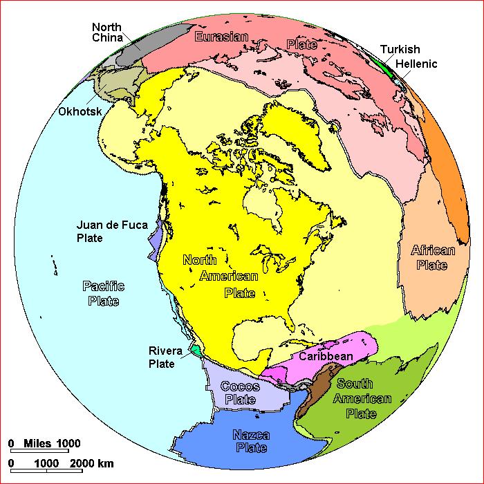
7 North American Plate

8 Tectonic Plates
9 Creating Landforms Topography: The natural features of the land s surface. Topography is described using the following terms Elevation: Height above sea level Relief: The difference in elevation between points Gradient: The steepness of slopes Geology: Types of rocks and the history of them General appearance: What do the features look like Landscape: an areas landforms together with its cover of vegetation water, ice, and rock. This includes all human features

10 Describe the topography of this photo.

11 Mountain Making Landforms are created by: Movement of the earth s crust Volcanoes


12 Movement in Earth s Crust 1. Fold Mountains: Occur When two crustal plates push together and the land bends due to the force of compression 2. Fault Block Mountains: Occur when moving magma separates, or compresses plates Separation causes block mountains Compression causes tilted blocks


13 How Landforms are Shaped The topography we see is shaped by four factors: 1. Mountain building: How landforms are created 2. Weathering: the wearing down forces of the atmosphere. 3. Erosion: The moving of weathered material 4. Deposition: Where eroded materials are dropped create new forms


14 Volcanos A volcano is most commonly a conical hill or mountain built around a vent that connects with reservoirs of molten rock below the surface of the Earth. Lava (liquid rock), gases and molten rock fragments called Ash OR Cinders flow through a fracture in the crust. These flows can be either violent eruptions or mild, slow flows!

15 Convection currents in the mantle
16 What causes them to erupt? Driven by buoyancy and gas pressure Molten rock, which is lighter than the surrounding solid rock, forces its way upward and may ultimately break though zones of weaknesses in the Earth's crust. Molten rock below the surface of the Earth that rises in volcanic vents is known as magma. After it erupts from a volcano it is called lava.
17 Canada s Landform Regions Canada has eight landform regions that are based on: Age of rock Type of rock Relief Gradient Process that has shaped the area

18 Canadian Shield Oldest rock in Canada 2 billion years old Foundation for other landforms Most of the shield has shallow acidic podzols Support coniferous growth Bad for farming Covers most of central Canada


19 Appalachian Mountains Formed around 375 million years ago when the Eurasian plate and the North American plate collided to form the super continent Pangea Mountains have been worn down by ice and water Typical height of the mountains is 1000m Covered mostly by mixed forest Found in most of Atlantic Canada

20 Western Cordillera Consists of a series of parallel mountain ranges Coast Mountains Columbia Mountains Rocky Mountains Many mountains over 3000m Many valleys with farming potential West facing slopes have great forests Found in British Columbia, Yukon, and Western Alberta

21 Innuitian Mountains Found in the far North Many over 2000m tall Steep sided Too cold for trees to grow


22 Arctic Lowlands Area to the south of the Innutian Mountains Mostly tundra Tundra: treeless plain Located mostly in Nunavut

23 Interior Plains Found between the Shield and Western Cordillera Created when a inland sea receded Made up of three prairie planes separated by two escarpments Steep slopes Fertile soil known as chernozem. Found in Alberta, Saskatchewan, Manitoba, and North West Territories

24 Great Lakes St. Lawrence Lowlands Found to the south of the Canadian Shield Flooded by Champlain sea nearly years ago. As sea receded left a flat area of very fertile soil Soil known as brown earth Extends from South Western Ontario along the Great Lakes and through Quebec


25 Hudson Bay Lowlands A low area of the shield with a build up of Paleozoic rock to a depth of 2000m Located in northern Ontario and Manitoba Flat and poorly drained Covered by swamps and trees
Grade 9 Social Studies Canadian Identity. Chapter 2 Review Canada s Physical Landscape
 Grade 9 Social Studies Canadian Identity Chapter 2 Review Canada s Physical Landscape Name: Unit 1: Empowerment Terms (notes or textbook) 1. Core 2. Crust 3. Mantle 4. Magma 5. Continental drift 6. Plate
CANADA S LANDFORM REGIONS
 CANADA S LANDFORM REGIONS Canada s Regions Canada is divided into Eight major regions. A Region is an area that is defined on the basis of the presence or absence of certain characteristics: Age of rock
Social Studies. Chapter 2 Canada s Physical Landscape
 Social Studies Chapter 2 Canada s Physical Landscape Introduction Canada s geography its landforms and climate - has a great impact on Canadians sense of identity. Planet Earth The earth is divided into
Chapter 6, Part Colonizers arriving in North America found extremely landscapes. It looked different to region showing great.
 Social Studies 9 Unit 1 Worksheet Chapter 6, Part 1. 1. Colonizers arriving in North America found extremely landscapes. It looked different to region showing great. 2. The Earth is years old and is composed
UNIT 1 - Major Land and Water Forms
 UNIT 1 - Major Land and Water Forms Chapter 1 - Landform Patterns and Processes Topography the natural and human features of the Earth s surface. ie. Surface features elevation - the height of a particular
Plate Tectonics. Chapter 8
 Plate Tectonics Chapter 8 Vocabulary Crust Mantle Core Lithosphere Continental Drift Plate Tectonics Plate Boundary Fault What Are The Earth s Layers Made Of? Atmosphere: Contains nitrogen, oxygen, carbon
Chapter 1: Landforms Patterns & Processes. Pg
 Chapter 1: Landforms Patterns & Processes Pg. 10-21 Video Time Physical Geography (6:02) Introduction: Earth is dynamic it behaves as if it s a living organism. Some changes are rapid enough for us to
World Geography 3202 Unit 1. Ch. 1: Landform Patterns and Processes
 World Geography 3202 Unit 1 Ch. 1: Landform Patterns and Processes - Planet Earth is dynamic - behaves as if it s a living organism - some changes are rapid enough for us to see and record - exs. Tidal
Topography the natural and human features of the Earth s surface. ie. Surface features need to understand difference between relief and elevation
 Chapter 1 Landform Patterns and Processes Highlighted script will not be assessed Topography the natural and human features of the Earth s surface. ie. Surface features need to understand difference between
World Geography 3202 Unit 1. Ch. 1: Landform Patterns and Processes
 World Geography 3202 Unit 1 Ch. 1: Landform Patterns and Processes - Planet Earth is dynamic - behaves as if it s a living organism - some changes are rapid enough for us to see and record - exs. Tidal
TAKE HOME EXAM 8R - Geology
 Name Period Date TAKE HOME EXAM 8R - Geology PART 1 - Multiple Choice 1. A volcanic cone made up of alternating layers of lava and rock particles is a cone. a. cinder b. lava c. shield d. composite 2.
01/12/2016. Introduction. Planet Earth. Plate Tectonics. Social Studies
 Introduction Social Studies Chapter 2 Canada s Physical Landscape Canada s geography its landforms and climate - has a great impact on Canadians sense of identity. Planet Earth The earth is divided into
Markville. CGC 1DL/PL Geography. Geography of Canada. Natural Environment Unit Test
 Markville CGC 1DL/PL Geography Geography of Canada Natural Environment Unit Test Name: Thinking /10 Knowledge /10 Application /10 Communication /10 Part A: Blanks (1 mark each) Thinking Choose the correct
8 th Grade Science Plate Tectonics and Topography Review
 8 th Grade Science Plate Tectonics and Topography Review #1 Scientists believe that the land masses of Earth were once joined together as one supercontinent called. A: Australia B: Wegner C: Pangaea D:
LANDFORM REGIONS IN CANADA. Classroom Notes and Descriptions
 LANDFORM REGIONS IN CANADA Classroom Notes and Descriptions Landform Regions in Canada There are eight distinct landforms in Canada: Western Cordillera Region Interior Plains Canadian Shield Hudson Bay
Earth Movement and Resultant Landforms
 Earth Movement and Resultant Landforms Structure of the Earth Lithosphere : earth s crust Asthenosphere : upper mantle zone where material is near its melting point & acts almost like liquid (appprox.
water erosion lithosphere Describe the process of erosion and deposition. chemical weathering Dissolving limestone is an example of.
 At one time, there was one large island off the coast of Mississippi and now it is two separate islands. What caused the island to be split into two? water erosion The crust and the top part of the upper
PLATE TECTONICS REVIEW GAME!!!!
 PLATE TECTONICS REVIEW GAME!!!! Name the four layers of the earth - crust - mantle - outer core - inner core Which part of Earth s structure contains tectonic plates? LITHOSPHERE Name one reason why the
I. Earth s Layers a. Crust: Earth s outside layer. Made of mostly rock. i. Continental: er; made of mostly granite, forms the continents and shallow
 I. Earth s Layers a. Crust: Earth s outside layer. Made of mostly rock. i. Continental: er; made of mostly granite, forms the continents and shallow sea beds, floats! ii. Oceanic: er; dense rock such as
UNIT 3 GEOLOGY VOCABULARY FLASHCARDS THESE KEY VOCABULARY WORDS AND PHRASES APPEAR ON THE UNIT 3 CBA
 UNIT 3 GEOLOGY VOCABULARY FLASHCARDS THESE KEY VOCABULARY WORDS AND PHRASES APPEAR ON THE UNIT 3 CBA A map that shows Earth s Topographic Map surface topography, which is Earth s shape and features Contour
LANDFORMS CREATED AND CHANGED?
 HOW ARE LANDFORMS CREATED AND CHANGED? Landforms are created by different natural forces. Some are within Earth, and some are on the surface of Earth. Landforms can also be changed by humans. These changes
Geology is the study of the structure and substance of the earth. The earth s physical features have been created by many geological events:
 UNIT 1 NOTES : GEOLOGY & THE EARTH S PHYSICAL STRUCTURE GEOLOGY & THE EARTH S PHYSICAL STRUCTURE Geology is the study of the structure and substance of the earth. The earth s physical features have been
Terrain Units PALEOGEOGRAPHY: LANDFORM CREATION. Present Geology of NYS. Detailed Geologic Map of NYS
 NYS TOPOGRAPHY Why so? PALEOGEOGRAPHY: LANDFORM CREATION Prof. Anthony Grande AFG 014 Present Geology of NYS Detailed Geologic Map of NYS Generalized Geology Detailed Geology Hot links to the fold out
deep within the planet. They are also shaped by conditions on the planet s surface. In
 Chapter 4 Landforms, Water, and Natural Resources Earth is home to many different types of landforms. These landforms are shaped by forces deep within the planet. They are also shaped by conditions on
GO ON. Directions: Use the diagram below to answer question 1.
 d i a g n o s t i c t e s t : e a r t h a n d s p a c e s c i e n c e question 1. 1. What is the correct order (starting from the surface) of Earth s layers? A crust, outer core, inner core, mantle B mantle,
Earth, the Lively* Planet. * not counting the life on the planet!
 Earth, the Lively* Planet * not counting the life on the planet! What We Will Learn Today What are planet Earth s features? What processes shape planetary surfaces? How does Earth s surface move? How did
Folding. Faulting. Volcanoes
 Folding Faulting Volcanoes Most major global mountain ranges were formed by the collision of continental (tectonic) plates Fold mountains are actually formed by crust which have been uplifted and folded
WHAT IS THE EARTH MADE OF? LITHOSPHERE AND HYDROSPHERE
 UNIT 8 WHAT IS THE EARTH MADE OF? LITHOSPHERE AND HYDROSPHERE TABLE OF CONTENTS 1 THE STRUCTURE OF THE EARTH... 2 2 THE FORMATION OF THE RELIEF: INTERNAL AND EXTERNAL FORCES.... 2 2.1 Internal forces:
Section 1: Earth s Interior and Plate Tectonics Section 2: Earthquakes and Volcanoes Section 3: Minerals and Rocks Section 4: Weathering and Erosion
 Section 1: Earth s Interior and Plate Tectonics Section 2: Earthquakes and Volcanoes Section 3: Minerals and Rocks Section 4: Weathering and Erosion Key Terms Crust Mantle Core Lithosphere Plate Tectonics
Earth Systems, Structures and Processes
 Earth Systems, Structures and Processes Date: 6.E.2 Understand the structure of the earth and how interactions of constructive and destructive forces have resulted in changes in the surface of the Earth
Outcome C&D Study Guide
 Name: Class: Outcome C&D Study Guide Identify the layers of Earth s interior Lithosphere the upper most layer of the earth that includes the crust and the hard outer mantle. It is fractured into tectonic
1. I can describe evidence for continental drift theory (e.g., fossil evidence, mountain belts, paleoglaciation)
") Science 10 Review Earth Science Vocabulary asthenosphere continental drift theory converging plates diverging plates earthquakes epicentre fault hot spot inner core lithosphere mantle mantle convection
Science 10 Review Earth Science Vocabulary asthenosphere continental drift theory converging plates diverging plates earthquakes epicentre fault hot spot inner core lithosphere mantle mantle convection
A physical feature of the Earth s surface
 Earth s Landforms A physical feature of the Earth s surface A physical feature of the Earth s surface LANDFORM Highest of Earth s physical features Highest of Earth s physical features MOUNTAIN Low area
Plate Tectonics. Continental Drift Sea Floor Spreading Plate Boundaries
 Plate Tectonics Continental Drift Sea Floor Spreading Plate Boundaries Continental Drift 1915, Alfred Wegener - Pangea hypothesis: suggested Earth s continents were part of a large super-continent 200
THE EARTH S RELIEF SOCIAL SCIENCES 1º ESO
 THE EARTH S RELIEF SOCIAL SCIENCES 1º ESO 1. THE STRUCTURE OF THE EARTH The Earth is divided into layers: The crust is the surface layer. It is a thin, solid layer made of rock. The Earth s crust has a
The Four Layers The Earth is composed of four different layers. The crust is the layer that you live on, and it is the most widely studied and
 Earth s Structure The Four Layers The Earth is composed of four different layers. The crust is the layer that you live on, and it is the most widely studied and understood. The mantle is much hotter and
Vocabulary Words. theory continental drift fault magma lava. weathering glacier erosion deposition delta
 Earth s Landforms Vocabulary Words theory continental drift fault magma lava weathering glacier erosion deposition delta Theory: A possible explanation. Continental drift: The continuing movement of the
Name: Geology Study Guide Date:
 Name: Geology Study Guide Date: Vocabulary You must know the following terms and definitions: 1. bedrock- a solid rock mass that is undisturbed by environmental conditions on the Earth s crust 2. Continental
Yanbu University College. General Studies Department. PHSC001 Course. Chapter9 (Basic Geology: Earthquakes and volcanoes ) Worksheet Solutions
 Worksheet Solutions") Yanbu University College General Studies Department PHSC001 Course Chapter9 (Basic Geology: Earthquakes and volcanoes ) Worksheet Solutions Phsc001 worksheet9 solutions, yuc Page 1-6 Chapter 9 worksheet
Yanbu University College General Studies Department PHSC001 Course Chapter9 (Basic Geology: Earthquakes and volcanoes ) Worksheet Solutions Phsc001 worksheet9 solutions, yuc Page 1-6 Chapter 9 worksheet
PALEOGEOGRAPHY of NYS. Definitions GEOLOGIC PROCESSES. Faulting. Folding 9/6/2012. TOPOGRAPHIC RELIEF MAP of NYS GRADATIONAL TECTONIC
 TOPOGRAPHIC RELIEF MAP of NYS PALEOGEOGRAPHY of NYS Prof. Anthony Grande AFG 2012 Definitions GEOLOGIC PROCESSES Geography: study of people living on the surface of the earth. Geology: the scientific study
Chapter Two. Figure 02_02. Geography of the Ocean Basins. The Sea Floor
 Chapter Two The Sea Floor Geography of the Ocean Basins Figure 02_02 The world ocean is the predominant feature on the Earth in total area. In the Northern Hemisphere, 61% of the total area is ocean. In
Plate Tectonic Review, Types of Plates
 Plate Tectonic Review, Types of Plates Review from last week: 1. Alfred Wegener: thought that sections of the Earth s crust moved, but people were confused, and thought that continents drifted over water
Exploring Inside the Earth
 Plate Tectonics Exploring Inside the Earth Geologists have used evidence from rock samples and evidence from seismic waves to learn about Earth s interior. Geologists are scientists who study the forces
Landforms in Canada. Canada is made up of three dis;nct types of landforms: Canadian Shield Highlands Lowlands
 Canada s Landforms What is a Landform? A landform is any physical feature of the Earth s surface having a characteris;c, recognizable shape, produced by natural causes. Landforms include major features
discussion of North America s physical features, including its landforms and bodies of
 Chapter 7 Natural Environments of North America Chapter 7 focuses on the natural environments of North America. The chapter opens with a discussion of North America s physical features, including its landforms
Refer to the map on page 173 to answer the following questions.
 Chapter 8-1 Plate Tectonics 1. Brainstorm the type of evidence that would indicate a climate change and how this evidence supports the theory of continental drift. Tropical fossils in cold regions Evidence
Chapter 2 Geography. Getting to know Earth
 Chapter 2 Geography Getting to know Earth Our Solar System Sun is at the center of our solar system Contains a lot of Mass» Mass gives the Sun gravitational pull» This keeps the planets in our solar system
Tuesday, September 05, 2017 Planet Earth
 Tuesday, September 05, 2017 Planet Earth Objective: Describe the solar system and Earth s location in it. Identify Earth s shape. Discuss Earth s structure. List Earth s landforms Do Now: What is a compass
CHAPTER 9. Basics Of geology: earthquakes & volcanoes
 161 CHAPTER 9 Basics Of geology: earthquakes & volcanoes CHAPTER s Objectives To introduce the theory of one supercontinent To discuss the clues and proofs that support the theory of one supercontinent
Plate Tectonics. Earth has distinctive layers - Like an onion
 Plate Tectonics Earth has distinctive layers - Like an onion Earth s Interior Core: Metallic (Iron, Nickel) Inner (hot, solid, dense, Iron, Nickel) Outer (cooler, liquid, less dense) Crust (outermost layer):
YORK CASTLE HIGH SCHOOL CHRISTMAS TERM EXAMINATIONS GEOGRAPHY Duration 1 1 /2 HRS.
 GRADE 9 YORK CASTLE HIGH SCHOOL CHRISTMAS TERM EXAMINATIONS GEOGRAPHY Duration 1 1 /2 HRS. Name: 1. Label the internal structure of the earth provided below. WRITE on the space provide. Oceanic Crust/Upper
Theory of Continental Drift
 Plate Tectonics Theory of Continental Drift Alfred Wegener suggested that continents had once been part of a supercontinent named Pangaea, that later broke up. The pieces moved apart over millions of years
Ch. 9 Review. Pgs #1-31 Write Questions and Answers
 Ch. 9 Review Pgs. 356-357 #1-31 Write Questions and Answers 356-357 #1-5 Answers 1. The layer of the upper mantle that can flow is the: A - Asthenosphere 2. Most scientists rejected Wegener s theory of
TEST NAME:Geology part 1 TEST ID: GRADE:06 - Sixth Grade SUBJECT:Life and Physical Sciences TEST CATEGORY: My Classroom
 TEST NAME:Geology part 1 TEST ID:1542715 GRADE:06 - Sixth Grade SUBJECT:Life and Physical Sciences TEST CATEGORY: My Classroom Geology part 1 Page 1 of 6 Student: Class: Date: 1. The picture below shows
Layers of the Earth Date: SWABT: Identify and describe the layers of the Earth and their characteristics
 Layers of the Earth SWABT: Identify and describe the layers of the Earth and their characteristics CRUST Composition: Thickness: State of Matter: : Mostly Basalt : Mostly Granite : Crust and Upper Mantle
Continental Drift. & Plate Tectonics
 Continental Drift & Plate Tectonics Alfred Wegener, a German scientist, proposed the hypothesis of CONTINENTAL DRIFT, in 1912. Hypothesis stated: All Earth s continents were once a single landmass (Pangaea)
Forces That Shape Earth. How do continents move? What forces can change rocks? How does plate motion affect the rock cycle?
 Forces That Shape Earth How do continents move? What forces can change rocks? How does plate motion affect the rock cycle? Plate Motion Mountain ranges are produced by plate tectonics. The theory of plate
sonar seismic wave basalt granite
 geologist sonar crust geology seismic wave mantle constructive force basalt inner core destructive force granite outer core The solid, rocky, surface layer of the earth. an instrument that can find objects
Unit 4 Lesson 6 Plate Tectonics
 Unit 4 Lesson 6 Plate Tectonics Indiana Standards 7.2.1 Describe how the earth is a layered structure composed of lithospheric plates, a mantle and a dense core. 7.2.4 Explain how convection currents in
Plate Tectonics. Chapter 17. Great Idea: The entire Earth is still changing, due to the slow convection of soft, hot rocks deep within the planet.
 Plate Tectonics Chapter 17 Great Idea: The entire Earth is still changing, due to the slow convection of soft, hot rocks deep within the planet. 1 Chapter Outline The Dynamic Earth Plate Tectonics: A Unifying
A Living Planet. Chapter PHYSICAL GEOGRAPHY. What you will learn in this chapter. Summary of the chapter
 QUIT Main Ideas What you will learn in this chapter Summary Summary of the chapter Test your geographic knowledge by playing the. Main Ideas Section 1: The Earth Inside and Out The earth is the only habitable
THE INTERNAL STRUCTURE OF THE EARTH
 UNIT 1 THE INTERNAL STRUCTURE OF THE EARTH 1.1.Earth s interior layers The interior of the Earth can be divided into layers according to: -Composition layers ( organized in order of increasing density
Theory of Plate Tectonics
 Plate Tectonics Theory of Plate Tectonics Lithosphere is made of sections called plates that move around called continental drift Plates move because they float on the asthenosphere Most plates consist
A) B) C) D) 4. Which diagram below best represents the pattern of magnetic orientation in the seafloor on the west (left) side of the ocean ridge?
 B) C) D) 4. Which diagram below best represents the pattern of magnetic orientation in the seafloor on the west (left) side of the ocean ridge?") 1. Crustal formation, which may cause the widening of an ocean, is most likely occurring at the boundary between the A) African Plate and the Eurasian Plate B) Pacific Plate and the Philippine Plate C)
1. Crustal formation, which may cause the widening of an ocean, is most likely occurring at the boundary between the A) African Plate and the Eurasian Plate B) Pacific Plate and the Philippine Plate C)
EARTH S INTERIOR, EVIDENCE FOR PLATE TECTONICS AND PLATE BOUNDARIES
 EARTH S INTERIOR, EVIDENCE FOR PLATE TECTONICS AND PLATE BOUNDARIES LAYERS OF THE EARTH Crust Inner Core Most Dense Solid Iron & Nickel Mantle Thickest layer Outer Core Liquid Iron & Nickel ANOTHER LOOK
LANDFORMS. Patterns and Processes
 LANDFORMS Patterns and Processes Structure From the surface the Earth is a planet of continents and oceans. There is constant motion on the earth s surface. Seismology is the study of earthquakes. Scientists
Directed Reading. Section: Volcanoes and Plate Tectonics
 Skills Worksheet Directed Reading Section: Volcanoes and Plate Tectonics 1. What can cause some of the most dramatic changes to Earth s surface? a. solar activity b. tides c. geysers d. volcanic eruptions
8 th Grade Campus Assessment- NSMS Plate Tectonics
 1. A group of students were discussing plate tectonics in their science class. All of the following statements about the tectonic plates are incorrect EXCEPT: A. The Eurasian Plate consists of the Asian
Distribution of Continents Mid-ocean Ridges Trenches. Deformation Metamorphism Volcanism Earthquakes
 Earthquakes and Plate Tectonics Global Problems in Geology Distribution of Continents Mid-ocean Ridges Trenches Orogenic Belts Deformation Metamorphism Volcanism Earthquakes Development of Continental
Plate Tectonics CHAPTER 17
 Plate Tectonics CHAPTER 17 Layers of the Earth A. Crust- solid, 5-70 km thick Moho Two Types of Crust: Oceanic- ocean floor, more dense then because of more iron Continental-dry land (mostly silicates
MARINE GEOLOGY & GEOGRAPHY
 MARINE GEOLOGY MARINE GEOLOGY & GEOGRAPHY Marine Geology 4 LAYERS OF THE EARTH CRUST THICKNESS: VARIES BETWEEN OCEAN & CONTINENTS 5-40 KM STATE: SOLID ELEMENTS: SILICON, ALUMINUM, CALCIUM, SODIUM, POTASSIUM
Canada is a country with diverse physical features.
 Chapter 3 Landforms Canada is a country with diverse physical features. With one of the longest coastlines in the world one can discover a variety of coastal features: bays, gulf, islands, peninsulas,
Earth s Interior StudyGuide
 Name Date Period Earth s Interior StudyGuide 1. The two main elements that make up the Earth s crust are and. 2. The Earth s inner core is made of solid and. 3. When one plates slides under another plate
Section 1: How Did Life Begin? Chapter 19: History of Life on Earth. Section 2: The Age of Earth
 Chapter 19: History of Life on Earth Section 1: How Did Life Begin? I. The Basic Chemicals of Life A. 1920s B. Earth s early oceans contained large amounts of organic molecules C. Molecules formed spontaneously
* If occurs, fossils that formed in shallow water may be found in water. Subsidence mean the crust is.
 Name Notes: Topic 5B Topic 5B: The Dynamic Crust A. What evidence exists that proves the Earth s Crust is and has moved? Earth Science 1. Tilted, folded or faulted strata Strata is a term that refers to.
THE DYNAMIC EARTH NOTES. Scientists divide the Earth into 4 parts or spheres. What are these spheres?
 Hon Environmental Science THE DYNAMIC EARTH NOTES. Scientists divide the Earth into 4 parts or spheres. What are these spheres? 1. geosphere 2. atmosphere 3. hydrosphere 4. biosphere Now, describe each
Plate Tectonics. By Destiny, Jarrek, Kaidence, and Autumn
 Plate Tectonics By Destiny, Jarrek, Kaidence, and Autumn .The Denali Fault and San Andreas Fault - The San Andreas Fault is a continental transform fault that extends roughly 1300 km (810 miles) through
Exploring Geography. Chapter 1
 Exploring Geography Chapter 1 The Study of Geography Geography is the study of where people, places, and things are located and how they relate to each other. Greek meaning writing about or describing
Chapter 7 Plate Tectonics. Plate tectonics accounts for important features of Earth s surface and major geologic events.
 Chapter 7 Plate Tectonics Plate tectonics accounts for important features of Earth s surface and major geologic events. 7-2 Alfred Wegener s Hypothesis of Continental Drift (1915) He noticed that the continents
CONTINENTAL DRIFT THEORY
 CONTINENTAL DRIFT THEORY Proof or crazy idea? CONTINENTAL DRIFT THEORY What is Continental Drift Theory? Continental drift theory (CDT): Alfred Wegener found all the continents were once together called
FORCES ON EARTH UNIT 3.2. An investigation into how Newton s Laws of Motion are applied to the tectonic activity on Earth.
 FORCES ON EARTH UNIT 3.2 An investigation into how Newton s Laws of Motion are applied to the tectonic activity on Earth. USE THESE NOTES: OUR HOME PLANET EARTH: What do you know about our planet? SO.HOW
Ch 17 Plate Tectonics Big Idea: Most geologic activity occurs at the boundaries between plates.
 Ch 17 Plate Tectonics Big Idea: Most geologic activity occurs at the boundaries between plates. 17.1 Drifting Continents 17.2 Seafloor Spreading 17.3 Plate Boundaries 17.4 Causes of Plate Motions Learning
Movement of the Earth s Crust: Formation of: Mountain s Plateau's and Dome s
 Movement of the Earth s Crust: Formation of: Mountain s Plateau's and Dome s References Information taken from several places including Prentice Hall Earth Science: @ http://www.eram.k12.ny.us/education/components/docmgr/default.php?sectiondetaili
Chapter 2 Plate Tectonics and the Ocean Floor
 Chapter 2 Plate Tectonics and the Ocean Floor Matching. Match the term or person with the appropriate phrase. You may use each answer once, more than once or not at all. 1. hydrothermal vents A. convergent
Tectonics. Planets, Moons & Rings 9/11/13 movements of the planet s crust
 Tectonics Planets, Moons & Rings 9/11/13 movements of the planet s crust Planetary History Planets formed HOT Denser materials fall to center Planet cools by conduction, convection, radiation to space
Earth s Dynamic Surface
 Earth s Dynamic Surface Shaping Earth s Surface What do you think? Read the two statements below and decide whether you agree or disagree with them. Place an A in the Before column if you agree with the
Plate Tectonics Practice Test
 Plate Tectonics Practice Test 1. What is the main idea Alfred Wegner proposed in the Theory of Continental Drift that he published in 1915? a. The continents float on a liquid layer that allows them to
Name Date Class. How have geologists learned about Earth s inner structure? What are the characteristics of Earth s crust, mantle, and core?
 Chapter 4 Plate Tectonics Section 1 Summary Earth s Interior How have geologists learned about Earth s inner structure? What are the characteristics of Earth s crust, mantle, and core? Earth s surface
Seafloor spreading is a geologic process in which tectonic plates large slabs of Earth's lithosphere split apart from each other.
 This website would like to remind you: Your browser (Apple Safari 4) is out of date. Update your browser for more security, comfort and the best experience on this site. Encyclopedic Entry seafloor spreading
SAC Geography Form 2 Chapter 3: Plate Tectonics Topic 3: Plate Movement
 What causes an earthquake? Plate movement causes pressure to build up along faults, or breaks, in the earth's crust. When the rocks cannot take any more pressure, the rock layers shift and an earthquake
12.2 Plate Tectonics
 12.2 Plate Tectonics LAYERS OF THE EARTH Earth is over 1200 km thick and has four distinct layers. These layers are the crust, mantle (upper and lower), outer core, and inner core. Crust outer solid rock
PART II. Physical Landscape Chapters 2 5
 PART II Physical Landscape Chapters 2 5 Prof. Anthony Grande 2016 Lecture design, content and presentation AFG 0616. Individual images and illustrations may be subject to prior copyright. R E M I N D E
1. What is Wegener s theory of continental drift? 2. What were the 4 evidences supporting his theory? 3. Why wasn t Wegener s theory excepted?
 Notebook 7a and 7b Objective (left-side): Students will be able to explain the theory of plate tectonics and be able to make predictions about plate interactions. Mapping Reflection 1. What is Wegener
Chapter 2 Earth s Interlocking Systems pg The Earth and Its Forces pg
 Chapter 2 Earth s Interlocking Systems pg. 24 55 2 1 The Earth and Its Forces pg. 27 33 Connecting to Your World and Internal Forces Shaping the Earth The Earth is unique in the solar system because it
EARTH S ENERGY SOURCES
 EARTH S ENERGY SOURCES The geological processes that shape the Earth s surface are powered by two major sources of energy; geothermal heat from the Earth s interior and external energy from the sun. The
Introduction to Plate Tectonics
 Introduction to Plate Tectonics The Theory of Plate Tectonics states that the crust of the Earth is divided into plates which are slowly moving. The plates cover earth s crust. You can imagine them as
TO GO TO ANY OF THE PAGES LISTED BELOW, CLICK ON ITS TITLE
 TO GO TO ANY OF THE PAGES LISTED BELOW, CLICK ON ITS TITLE CHAPTER 6 Plate Tectonics 1 6-1 What is continental drift? 2 6-2 Why is the seafloor spreading? 3 6-3 What evidence supports seafloor spreading?
PLATE TECTONICS. SECTION 17.1 Drifting Continents
 Date Period Name PLATE TECTONICS SECTION.1 Drifting Continents In your textbook, read about continental drift. Circle the letter of the choice that best completes each statement. 1. Early mapmakers thought
4 Layers of the earth 7 main plates of the earth 3 main plate boundaries 2 types of crust 3 main features of plate tectonics 3 main theorists and
 4 Layers of the earth 7 main plates of the earth 3 main plate boundaries 2 types of crust 3 main features of plate tectonics 3 main theorists and theories Human interaction The Earth is made up of 3 main
22.4 Plate Tectonics. Africa
 The Red Sea between Africa and the Arabian peninsula in Asia marks a region where two pieces of the lithosphere are slowly moving apart. Over the next 100 million years, the Red Sea could become an ocean.