Understanding coastal erosion in Alaska
|
|
|
- Shonda Charles
- 5 years ago
- Views:
Transcription
1 Understanding coastal erosion in Alaska Alaska Center for Climate Assessment and Policy Statewide Teleconference October 9, David E. Atkinson International Arctic Research Center / Atmospheric Science Program University of Alaska Fairbanks
2 Coastal erosion: Significant, immediate/near-term threat for many Alaska (and Arctic) communities Several AK villages are in need of emergency intervention Shishmaref Newtok Kivalina Many more are threatened US Army Corps of Engineers reports Baseline Technical Erosion report (2006) Information Paper (July 2007) US General Accounting Office (GAO 2003)
 Photo: Tony")
3 Coastal erosion (Shishmaref October 2004) Photo: Tony Weyiouanna Sr.
 Photo: Ned")
4 Coastal erosion (Shishmaref October 2005) Photo: Ned Rozell

5 Photos: Tony Weyiouanna Sr. Shishmaref bluff retreat severe erosion caused by

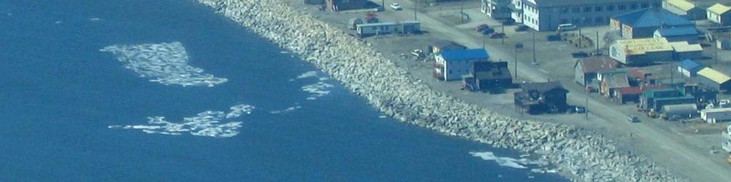
6 waves Teller, AK
 Teller,")
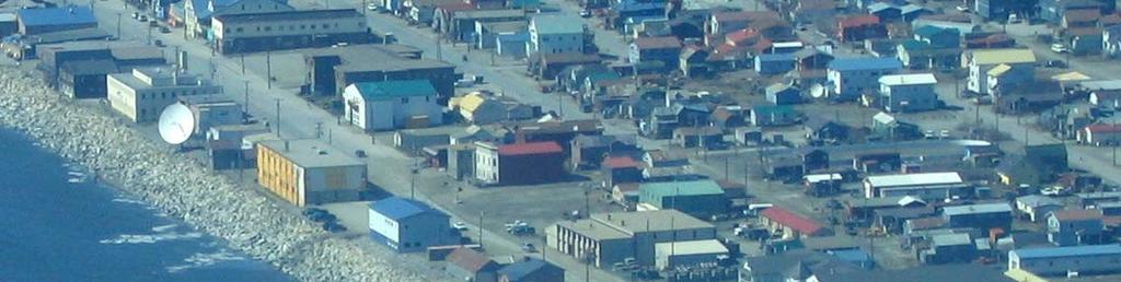
7 and flooding (inundation storm and tsunami) Teller, AK
 Teller,")
8 and flooding (inundation storm and tsunami) Teller, AK
9 Both of these are responses of the water to being "forced" by a "driver" > Unlike the south, this response is altered by ice > Ice greatly complicates study and understanding > Also must consider the sea depth near the shore > shallow shelf vs. deep water > Erosion response also dependent on the coast > type of sediment (rocks or loose) > ice in the ground > shore facing (cliff/no cliff) > stabilizing vegetation
10 Waves Waves caused by wind drag transfer of wind energy to water > Stronger wind = more energy = higher waves > Also stable winds (persistent) > And long fetches of open water > Combination gives very large waves
11 How do waves erode? Kinetic energy just like a car crash
12 How do waves erode? Kinetic energy just like a car crash Do the math! Two cubic yards of water 6 feet wide, 3 feet high, 3 feet deep = two tons a mid-size car hitting at 31 miles per hour one every 10 seconds! - of course water is not rigid but there is still a lot of force recall standing in the surf
13 What happens to all this energy as waves near the coast? Why aren t they hammering all coasts into oblivion?
14 What happens to all this energy as waves near the coast? Why aren t they hammering all coasts into oblivion? > Wave energy is dissipated as they move up the beach slope
15 Foreshorten and break as approach shallows Shallow slope provides for energy dissipation = weak waves at the beach and no heavy impact (recall Teller photo) Steeper shoreface = less energy dissipation = stronger waves at the beach
16 Surges Persistent wind (direction, speed maintained) near the coast can lead to surges > Short-term increases in water level (several hours) cause > flooding (inundation) > allow waves to attack higher up on bluff > arguably the most damaging coastal impact of a storm

17 And Nome (Oct. 2004)
18 Nome, AK during the storm

19 Nome, AK Front Street (where the Iditarod finishes)
20 Return to ICE Said that ice complicates things how for the marine side?
21 Add sea ice waves are reduced
22 Ice frozen into the ground at the coast - "land fast" or "shore fast" ice - armors and protects the coast against waves - And thus: Trends of later freezeup and earlier melt expose the coast to greater potential damage
23 If sea ice is not land fast the wind can move ice ashore as an "ice push" an "ivu"

24 Barrow ivu 2006 Photo of Anne Jensen taken by Alice Brower.
25 Taken by me in Gambell, May 2006
26 Ice on the terrestrial side Permafrost permanently frozen ground > Very strong when frozen > Very weak when melted mud, essentially
27 Permafrost can be melted > By the relatively warm water > By warm temperatures/solar radiation


28 Permafrost coasts Cliff notching and slope slump failure High wave energy + positive surge S. Solomon, Cdn Beaufort S. Solomon, Cdn Beaufort Thermal stress on ice bodies Arctic Coastal Dynamics 5 th Annual meeting Montréal, Canada Block failure S. Solomon, Cdn Beaufort A. Mahoney, US Beaufort V. Rachold, East Siberian V. Rachold, Laptev
29 In fact for arctic coasts Trying to calculate rates of erosion using only wave energy will not give you the whole story
30 Responses - storms research - coastal dynamics research - partnerships with NOAA and EPA - partnerships with educational outreach
31 Nome storm counts


32

33 Compilation: Brown, Jordan and Graves
34 Responses: projects I have underway NOAA Cooperative Institute for Arctic Research (NOAA-CIFAR office, UAF) Pacific Region Integrated Data Enterprise (2 projects) 1. With James Partain of NOAA s National Weather Service (Anchorage) directly improve NOAA s coastal forecast ability 2. With John Marra/Eileen Shea of NOAA s Pacific Services Center (Honolulu) develop climatology products tailored to end-users NOAA Oceanic and Atmospheric Research (NOAA OAR) Social Vulnerability to Climate Change in Alaska Coastal Communities Large, interdisciplinary project Anthropology, Marine Ecology, Weather Modeling, Climate research Work directly with communities to identify specific problematic weather types and trends EPA Office of Research and Development (EPA ORD and Region 10) Improved Inundation-Hazard Warning Capacity in the Arctic Coastal Zone With John Lyon and Jackie Poston parntership with NOAA to support development of detailed wave modeling for AK
")
35 Responses data gathering for wind analysis (partner with a UAF Geophysical Institute education project)
36 Take home points: Reduction of sea ice is a major problem for erosion In the Arctic erosion must be considered in terms of wave energies and temperature (melt) permafrost issues Surges must be factored in flooding/inundation events worsen wave erosion
37 Thank you questions?
Coastal Erosion & Climate Change: PRIDE 2005 Towards an Alaska Wind/Wave Climatology
 Coastal Erosion & Climate Change: PRIDE 2005 Towards an Alaska Wind/Wave Climatology 2 nd PRIDE Workshop August 9-10, 2005 David Atkinson, Int l Arctic Research Center, Univ. Of Alaska-Fairbanks James
Climate Change Impacts in Alaska: the Weather Perspective
 Climate Change Impacts in Alaska: the Weather Perspective September 18, 2007 NOAA s National Weather Service, Alaska Region James Partain, Chief Environmental and Scientific Services Division NOAA NWS
5. MANY COASTAL COMMUNITIES AND FACILITIES WILL FACE INCREASING EXPOSURE TO STORMS.
 5. MANY COASTAL COMMUNITIES AND FACILITIES WILL FACE INCREASING EXPOSURE TO STORMS. Climate change is altering the Arctic coastline and much greater changes are projected for the future as a result of
CLIMATE CHANGE AND SHORT-TERM FORECASTING FOR ALASKAN NORTHERN COASTS Gary Hufford * and James Partain National Weather Service, Anchorage, Alaska
 CLIMATE CHANGE AND SHORT-TERM FORECASTING FOR ALASKAN NORTHERN COASTS Gary Hufford * and James Partain National Weather Service, Anchorage, Alaska 1. INTRODUCTION Global climate models project that the
Changing Landscapes. Coastal Erosion. Middle School Guide. REACH Up Raising Educational Achievement. through Cultural Heritage Up
 Changing Landscapes Coastal Erosion Middle School Guide REACH Up Raising Educational Achievement through Cultural Heritage Up Changing Landscapes How does climate change impact the landscape? The climate
Erosion Information Paper - Barrow, Alaska Current as of September 14, 2007
 U.S. Army Corps of Engineers ALASKA BASELINE EROSION ASSESSMENT Erosion Information Paper - Barrow, Alaska Current as of September 14, 2007 Community Information Barrow (BARE-row, a.k.a. Ukpeagvik), population
Ellen L. Mecray NOAA Regional Climate Services Director, Eastern Region Taunton, MA
 Ellen L. Mecray NOAA Regional Climate Services Director, Eastern Region Taunton, MA Regions of the US National Climate Assessment What we Observe: Climate changes and impacts Extreme precipitation and
Sea-ice change around Alaska & Impacts on Human Activities
 Sea-ice change around Alaska & Impacts on Human Activities Hajo Eicken Geophysical Institute University of Alaska Fairbanks, hajo.eicken@gi.alaska.edu Introduction The Arctic sea-ice cover: Observations
Impact of Climate Change on Alaska Native Communities
 Impact of Climate Change on Alaska Native Communities Alaska Native Science Commission www.nativescience.org www.nativeknowledge.org Climate Change Affects Community Way of Life Alaska Natives have always
Regional Outlook for the Bering-Chukchi-Beaufort Seas Contribution to the 2018 Sea Ice Outlook
 Regional Outlook for the Bering-Chukchi-Beaufort Seas Contribution to the 2018 Sea Ice Outlook 25 July 2018 Matthew Druckenmiller (National Snow and Ice Data Center, Univ. Colorado Boulder) & Hajo Eicken
The known requirements for Arctic climate services
 The known requirements for Arctic climate services based on findings described in STT White paper 8/2015 Johanna Ekman / EC PHORS STT Regional drivers The Arctic region is home to almost four million people
Western Alaska Buoy Deployment and Data Streaming. Author of Report Molly McCammon, AOOS,
 1. PROJECT INFORMATION Title: Western Alaska Buoy Deployment and Data Streaming Report period December 31, 2012 May 27, 2015 Report submission date May 27, 2015 (rec d 27 May; rev d 27 May; resp d 27 May;
Geol 117 Lecture 18 Beaches & Coastlines. I. Types of Coastlines A. Definition:
 I. Types of Coastlines A. Definition: 1. Shore = narrow zone where ocean meets land (e.g. beach) 2. Coast is a broad area where both ocean and land processes act a. Includes onshore marshes, dunes, sea
Tony Pratt, DNREC to The Center for the Inland Bays Scientific and Technical Advisory Committee. August 21, 2009
 Sea Level Rise in Delaware Presented by Tony Pratt, DNREC to The Center for the Inland Bays Scientific and Technical Advisory Committee August 21, 2009 Sea level has been fluctuating ever since there have
NOAA Arctic Priorities and Potential Contributions to PPP/YOPP. Randall Dole NOAA Earth System Research Laboratory Physical Sciences Division
 NOAA Arctic Priorities and Potential Contributions to PPP/YOPP Randall Dole NOAA Earth System Research Laboratory Physical Sciences Division 1 NOAA s Arctic Goals Forecast Sea Ice Strengthen Foundational
Prolonged Coastal Storm October 9 th -12 th, 2013
 Prolonged Coastal Storm October 9 th -12 th, 2013 Prepared 400 PM EDT Tuesday, October 8th, 2013 Gary Szatkowski NOAA s NJ Forecast office http://www.erh.noaa.gov/phi/ Purpose of Briefing Briefing #1 for
Preliminary Vulnerability Assessment of Coastal Flooding Threats - Taylor County, Florida
 Preliminary Vulnerability Assessment of Coastal Flooding Threats - Taylor County, Florida North Central Florida Regional Planning Council Northeast Florida Regional Council April 28, 2016 BACKGROUND This
Ellen L. Mecray NOAA Regional Climate Services Director, Eastern Region Taunton, MA
 Ellen L. Mecray NOAA Regional Climate Services Director, Eastern Region Taunton, MA Regions of the US National Climate Assessment What we Observe: Climate changes and impacts Increasing temperature Increasingly
Whither Arctic Sea Ice?
 Cooperative Institute for Research in Environmental Sciences University of Colorado Whither Arctic Sea Ice? Walt Meier http://nsidc.org Climate Literacy and Energy Awareness Network May 9, 2011 1 The Cryosphere
Hurricanes and typhoons are taking their cues from a changing global climate
 Hurricanes and typhoons are taking their cues from a changing global climate By Los Angeles Times, adapted by Newsela staff on 06.18.18 Word Count 921 Level 1050L Image 1. Flooding submerged a road after
Global Climate Change
 Global Climate Change Overview: Students will learn about global climate change, what causes global warming, and scientific projections about climate change in the near future. Levels V-VI Grades 9-12
What Are Disasters? The Rescue Kids Trio!
 The Rescue Kids Trio! What Are Disasters? This manual was made possible through funding by the Council of Local Authorities for International Relations. Disasters and emergency preparedness Emergency preparedness
Guided Notes Weather. Part 2: Meteorology Air Masses Fronts Weather Maps Storms Storm Preparation
 Guided Notes Weather Part 2: Meteorology Air Masses Fronts Weather Maps Storms Storm Preparation The map below shows North America and its surrounding bodies of water. Country borders are shown. On the
Name Earth Science Pd. Hurricanes. Directions: Read the information, view diagrams and answer the questions in the worksheet.
 Hurricanes Directions: Read the information, view diagrams and answer the questions in the worksheet. Hurricane Basics The ingredients for a hurricane include a pre-existing weather disturbance, warm tropical
Sea-level Rise on Cape Cod: How Vulnerable Are We? Rob Thieler U.S. Geological Survey Woods Hole, MA
 Sea-level Rise on Cape Cod: How Vulnerable Are We? Rob Thieler U.S. Geological Survey Woods Hole, MA Outline Sea-level and coastal processes Past sea-level change Predictions for the future Coastal responses
Alaska PRIDE wind/wave climatology workshop: Motivation, results
 Alaska PRIDE wind/wave climatology workshop: Motivation, results David E. Atkinson International Arctic Research Center / Atmospheric Sciences Department University of Alaska Fairbanks James Partain National
How does erosion happen?
 How does erosion happen? By National Geographic, adapted by Newsela staff on 10.03.17 Word Count 682 Level 830L These rock formations, in Bryce Canyon National Park, Utah, are called hoodoos. Although
Hurricane Florence: Rain this heavy comes along once every 1,000 years
 Hurricane Florence: Rain this heavy comes along once every 1,000 years By Associated Press, adapted by Newsela staff on 09.17.18 Word Count 786 Level 810L Image 1. This satellite image provided by the
Climate Change in Newfoundland & Labrador
 Climate Change in Newfoundland & Labrador Impacts and Adaptation Newleef Conference 08 October 2015 Met-Ocean Services The Team 55 personnel; 24/7 operational weather forecast desk; Equipment technician
Village Weather, Snow, Ice, Breakup, Flooding, Fire sites
 Village Weather, Snow, Ice, Breakup, Flooding, Fire sites What is the weather like now in Villages?... 1 BREAKUP:... 2 Flooding... 3 Fires... 5 Weather Predictability, Weather and Ice Advisories and How
STORM WATER LEVEL FEATURE EXTRACTION FROM DIGITAL ELEVATION MODELS USING INTRA-STORM PHOTOGRAPHS
 Alaska Division of Geological & Geophysical Surveys Report of Investigations 2017-6 STORM WATER LEVEL FEATURE EXTRACTION FROM DIGITAL ELEVATION MODELS USING INTRA-STORM PHOTOGRAPHS Jacquelyn R. Overbeck
Erosion Information Paper - South Naknek, Alaska Current as of November 14, 2007
 U.S. Army Corps of Engineers ALASKA BASELINE EROSION ASSESSMENT Erosion Information Paper - South Naknek, Alaska Current as of November 14, 2007 Community Information South Naknek (NACK-neck), originally
Mapping of Future Coastal Hazards. for Southern California. January 7th, David Revell, Ph.D. E.
 Mapping of Future Coastal Hazards for Southern California January 7th, 2014 David Revell, Ph.D. drevell@esassoc.com E. Vandebroek, 2012 Outline Coastal erosion hazard zones Flood hazard zones: Coastal
NOAA s National Weather Service Philadelphia/Mt. Holly NJ
 Next Briefing Package: Friday, October 2, 2015 no later than 300 PM Hazards and Impacts: Overview: A dangerous weather pattern still threatens our region. Threats include very heavy rainfall, inland river
The Marine Environment
 The Marine Environment SECTION 16.1 Shoreline Features In your textbook, read about erosional landforms, beaches, estuaries, longshore currents, and rip currents. For each statement below, write or. 1.
Coastal Inundation Forecasting Demonstration Project CIFDP. Flood Forecasting Initiative-Advisory Group (FFI-AG 3), Geneva, 5-7 Dec, 2017
, Geneva, 5-7 Dec, 2017") Coastal Inundation Forecasting Demonstration Project CIFDP Flood Forecasting Initiative-Advisory Group (FFI-AG 3), Geneva, 5-7 Dec, 2017 Coastal Flooding & Vulnerable Populations Coastal populations are
Coastal Inundation Forecasting Demonstration Project CIFDP Flood Forecasting Initiative-Advisory Group (FFI-AG 3), Geneva, 5-7 Dec, 2017 Coastal Flooding & Vulnerable Populations Coastal populations are
Alaska Statewide Climate Summary February 2019
 Alaska Statewide Climate Summary February 2019 The following report provides an overview of the February 2019 weather. The report is based on preliminary data from selected weather stations throughout
AIR MASSES. Large bodies of air. SOURCE REGIONS areas where air masses originate
 Large bodies of air AIR MASSES SOURCE REGIONS areas where air masses originate Uniform in composition Light surface winds Dominated by high surface pressure The longer the air mass remains over a region,
North Slope Trends in Sea Level, Storm Frequency, Duration and Intensity
 North Slope Trends in Sea Level, Storm Frequency, Duration and Intensity Nels J. Sultan, Kenton W. Braun and Dempsey S. Thieman PND Engineers, Inc. Anchorage, Alaska, USA nsultan@pndengineers.com ABSTRACT
EROSION AND DEPOSITION
 CHAPTER 8 EROSION AND DEPOSITION SECTION 8 1 Changing Earth s Surface (pages 252-255) This section explains how sediment is carried away and deposited elsewhere to wear down and build up Earth s surface.
Hurricane Matthew. National Weather Service Wilmington NC. Steven Pfaff, WCM.
 Hurricane Matthew Threat Assessment for northeast South Carolina & southeast North Carolina National Weather Service Wilmington NC 730 AM EDT Tuesday October 4, 2016 Steven Pfaff, WCM Steven.Pfaff@noaa.gov
The Marine Environment
 The Marine Environment SECTION 16.1 Shoreline Features In your textbook, read about erosional landforms, beaches, estuaries, longshore currents, and rip currents. For each statement below, write true or
What are the consequences of melting pack ice?
 The Hydrosphere s Cryosphere: A-Pack Ice: (Sea Ice) They are large sheets of ice found in the oceans around Antarctica and in the Arctic Ocean. Smaller ones are called ice floes. Example 1: What are the
Draft for Discussion 11/11/2016
 Coastal Risk Consulting (CRC) Climate Vulnerability Assessment for Village of Key Biscayne Deliverable 1.1 in Statement of Work. Preliminary Vulnerability Assessment Identifying Flood Hotspots Introduction...
Physical landscapes River landscapes in the UK
 Physical landscapes River landscapes in the UK The shape of river valleys change s as rivers flow downstream - PROCESSES Erosion Abrasion or corrasion Attrition Hydraulic Action Solution or corrosion Deposition
Frank Revitte National Weather Service. Weather Forecast Office New Orleans/Baton Rouge
 Frank Revitte National Weather Service Weather Forecast Office New Orleans/Baton Rouge Above normal activity 17 Total Named Storms 7 Tropical Storms 4 Hurricanes 6 Major Hurricanes Not the most active,
Storm and Storm Systems Related Vocabulary and Definitions. Magnitudes are measured differently for different hazard types:
 Storm and Storm Systems Related Vocabulary and Definitions Magnitude: this is an indication of the scale of an event, often synonymous with intensity or size. In natural systems, magnitude is also related
Diagnosing the Large Swell Event Associated with the Extratropical Transition of Hurricane Florence
 Diagnosing the Large Swell Event Associated with the Extratropical Transition of Hurricane Florence Mark Willis National Hurricane Center Tropical Analysis and Forecast Branch (TAFB) Thanks to: Jack Beven,
Community Erosion Assessment Napakiak, Alaska 15 January 2008
 1. Community: Napakiak, Alaska Community Erosion Assessment Napakiak, Alaska 15 January 2008 Figure 1: Napakiak Location & Vicinity Map 2. Community Profile Summary: Napakiak is a 2 nd class city of 378
The Field Research Facility, Duck, NC Warming Ocean Observations and Forecast of Effects
 The Field Research Facility, Duck, NC Warming Ocean Observations and Forecast of Effects A potential consequence of a warming ocean is more frequent and more intense wind events (Hurricanes & Typhoons)
Surviving Tsunamis on the Oregon Coast
 Slide 1 Surviving Tsunamis on the Oregon Coast Coastal Engineers Think Inside the Box This talk generally covers civil engineering, coastal engineering, and how engineers work within limitations to create
12/2/15. Providing observa.ons, data and informa.on products to meet agency and stakeholder needs
 12/2/15 Providing observa.ons, data and informa.on products to meet agency and stakeholder needs 1 Part of the Integrated Ocean Observing System (IOOS) Governed through a Memorandum of Agreement Fiscal
JCOMM-CHy Coastal Inundation Forecasting Demonstration Project (CIFDP)
") WMO World Meteorological Organization Working together in weather, climate and water JCOMM-CHy Coastal Inundation Forecasting Demonstration Project (CIFDP) Coastal Flooding & Vulnerable Populations Coastal
WMO World Meteorological Organization Working together in weather, climate and water JCOMM-CHy Coastal Inundation Forecasting Demonstration Project (CIFDP) Coastal Flooding & Vulnerable Populations Coastal
Randall W. Parkinson, Ph.D., P.G. Institute of Water and Environment Florida International University
 An Update on Adaptation Action Activities Undertaken Since Completion of the City of Satellite Beach (FL) Vulnerability Assessment to Rising Seas (2010) Randall W. Parkinson, Ph.D., P.G. Institute of Water
Hurricane Matthew Threats and Impacts Briefing for Eastern NC
 Hurricane Matthew Threats and Impacts Briefing for Eastern NC October 6 th, 2016 Date/Time Created: 10/6/2016, Noon EDT National Weather Service Newport/Morehead City, NC Hurricane Matthew Key Points Changes
Sea Ice Prediction Network (SIPN) Webinar: Industry Needs for Seasonal and Sub-seasonal Sea Ice Information and Predictions
 Webinar: Industry Needs for Seasonal and Sub-seasonal Sea Ice Information and Predictions") Sea Ice Prediction Network (SIPN) Webinar: Industry Needs for Seasonal and Sub-seasonal Sea Ice Information and Predictions Hajo Eicken International Arctic Research Center University of Alaska Fairbanks,
Sea Ice Prediction Network (SIPN) Webinar: Industry Needs for Seasonal and Sub-seasonal Sea Ice Information and Predictions Hajo Eicken International Arctic Research Center University of Alaska Fairbanks,
NWS HURRICANES June 3, 2015
 NWS HURRICANES June 3, 2015 Hurricane Season June 1 November 30 2 What s the concern? All tropical systems passing within 125nm of central Maryland since 1950 Mid-Atlantic Hurricanes Greatest Risk: August
ELEVATION IS FOUNDATIONAL. A DEM that is inaccurate or of poor resolution will pass those characteristics onto other data layers
 ELEVATION IS FOUNDATIONAL A DEM that is inaccurate or of poor resolution will pass those characteristics onto other data layers THE DEM IS FOUNDATIONAL TO ALL GIS (Geospatial Information System) LAYERS
Alaska villagers face dual threat of hungry polar bears, warmer weather
 Alaska villagers face dual threat of hungry polar bears, warmer weather By PBS NewsHour, adapted by Newsela staff on 10.24.16 Word Count 869 A polar bear roams Alaska. Photo: Photo by Hoberman Collection/UIG
Phillip Island Nature Parks Coastal Process Study 8 October 2014
 Phillip Island Nature Parks Coastal Process Study 8 October 2014 Project Overview Coastal Geology Basaltic and fragmented lavas, granite at Pyramid Rock and Cape Woolamai Weathered basalt (>10m thick)
What We Know about the Climate Change Hurricane Connection Some links are indisputable; others are more subtle, but the science is improving all the
 What We Know about the Climate Change Hurricane Connection Some links are indisputable; others are more subtle, but the science is improving all the time By Michael E. Mann, Thomas C. Peterson, Susan Joy
ALASKA DEEP-DRAFT ARCTIC PORT EVALUATION
 ALASKA DEEP-DRAFT ARCTIC PORT EVALUATION Joint Study of Federal and State June 20, 2012 Opportunity and Constraint Warming of Arctic region is leading to new maritime opportunities. Thawing of permafrost
SLOSH New Orleans Basin 2012 Update
 SLOSH New Orleans Basin 2012 Update Michael Koziara Science and Operations Officer National Weather Service Slidell, LA The Basics What is storm surge? What is SLOSH? Details Assumptions Inundation = Storm
Andy Mahoney, Hajo Eicken, Josh Jones
 First Annual Partners Meeting Presentation Integrated Framework to Identify, Track and Communicate Sea-Ice Hazards Arctic Domain Awareness Center (ADAC) A DHS Center of Excellence Andy Mahoney, Hajo Eicken,
Coastal Evolution in Sedimentary Areas in Greenland
 Coastal Evolution in Sedimentary Areas in Greenland Mette Bendixen P h D s t u d e n t DANCORE Young Professionals Day Dias 1 Outline Motivation State of the art on Arctic coasts Purpose of my Phd Presentation
Developed in Consultation with Florida Educators
 Developed in Consultation with Florida Educators Table of Contents Next Generation Sunshine State Standards Correlation Chart... 7 Benchmarks Chapter 1 The Practice of Science...................... 11
 Permafrost http://www.cbc.ca/news/canada/story/2011/11/16/north-bigfix-permafrost.html 1. What is permafrost? Permafrost is a thick layer of permanently frozen ground. 2. Large parts of northeastern Russia
Alaska Ocean Observing System 101 Anchorage, Alaska
 Alaska Ocean Observing System 101 Anchorage, Alaska Molly McCammon, Director Alaska Ocean Observing System (AOOS) A Regional Observing System within the Integrated Ocean Observing System www.aoos.org IOOS
Improving global coastal inundation forecasting WMO Panel, UR2014, London, 2 July 2014
 Improving global coastal inundation forecasting WMO Panel, UR2014, London, 2 July 2014 Cyclone Sidr, November 2007 Hurricane Katrina, 2005 Prof. Kevin Horsburgh Head of marine physics, UK National Oceanography
Biosphere. All living things, plants, animals, (even you!) are part of the zone of the earth called the biosphere.
 are part of the zone of the earth called the biosphere.") Unit 1 Study Guide Earth s Spheres Biosphere All living things, plants, animals, (even you!) are part of the zone of the earth called the biosphere. Hydrosphere Water covers ¾ of the earth, made up mostly
Unit 1 Study Guide Earth s Spheres Biosphere All living things, plants, animals, (even you!) are part of the zone of the earth called the biosphere. Hydrosphere Water covers ¾ of the earth, made up mostly
Ice Sheets and Sea Level -- Concerns at the Coast (Teachers Guide)
") Ice Sheets and Sea Level -- Concerns at the Coast (Teachers Guide) Roughly 153 million Americans (~53% of the US population) live in coastal counties. World wide some 3 billion people live within 200 km
Ice Sheets and Sea Level -- Concerns at the Coast (Teachers Guide) Roughly 153 million Americans (~53% of the US population) live in coastal counties. World wide some 3 billion people live within 200 km
Unit 1: Water Systems on Earth Chapter 2
 Unit 1: Water Systems on Earth Chapter 2 Create a mind map with the driving question, Why are Oceans Important? Remember: Why are oceans so important? Why are oceans so important? Primary water source
Queensland Floods- Part A
 Queensland Floods- Part A Floods Flooding is when the water level in a creek, river, lake or the sea rises and covers land that is normally dry. The rise in water can be due to numerous causes, although
The Coast: Beaches and Shoreline Processes
 1 2 3 4 5 6 7 8 9 The Coast: es and Shoreline Processes Trujillo & Thurman, Chapter 10 Oceanography 101 Chapter Objectives Recognize the various landforms characteristic of beaches and coastal regions.
"The Big One" by sea and not by land
 "The Big One" by sea and not by land By Los Angeles Times, adapted by Newsela staff on 03.24.14 Word Count 629 Surfer Lee Johnson emerges from the water at San Onofre State Beach, Calif., with the twin
water erosion lithosphere Describe the process of erosion and deposition. chemical weathering Dissolving limestone is an example of.
 At one time, there was one large island off the coast of Mississippi and now it is two separate islands. What caused the island to be split into two? water erosion The crust and the top part of the upper
Storms. 3. Storm types 4. Coastal Sectors 5. Sorm Location and Seasonality 6. Storm Severity 7. Storm Frequency and grouping 8. The design storm event
 1. Introduction Storms 2. The Impact of Storms on the coast 3. Storm types 4. Coastal Sectors 5. Sorm Location and Seasonality 6. Storm Severity 7. Storm Frequency and grouping 8. The design storm event
The Coast: Beaches and Shoreline Processes Trujillo & Thurman, Chapter 10
 The Coast: es and Shoreline Processes Trujillo & Thurman, Chapter 10 Oceanography 101 Chapter Objectives Recognize the various landforms characteristic of beaches and coastal regions. Identify seasonal
Hurricane Matthew Life Threatening Flash Flooding Likely
 Hurricane Matthew Life Threatening Flash Flooding Likely Threat Assessment for northeast South Carolina & southeast North Carolina National Weather Service Wilmington NC 12 AM EDT Saturday October 8, 2016
Lab 12 Coastal Geology
 Lab 12 Coastal Geology I. Fluvial Systems Hydrologic Cycle Runoff that flows into rivers = precipitation (rain and snowmelt) [infiltration (loss to groundwater) + evaporation (loss to atmosphere) + transpiration
Alaska Climate Teleconferences Hosted by the Alaska Center for Climate Assessment and Policy
 Alaska Climate Teleconferences Hosted by the Alaska Center for Climate Assessment and Policy ALASKA CLIMATE VARIABILITY IN THE MODERN ERA Rick Thoman, National Weather Service Wednesday, January 21, 2009;
2nd Grade. Wind, Water and Land.
 1 2nd Grade Wind, Water and Land 2015 11 23 www.njctl.org 2 Wind, Water and Land What is Wind? Wind Erosion Preventing Wind Erosion Water Erosion Sudden Water Erosion Preventing Water Erosion Landforms
Atmosphere Weather and Climate
 Atmosphere Weather and Climate Weather and Climate Weather Atmospheric conditions at a particular time and place Climate Long-term average of weather conditions Often over decades or centuries Coastal
1 Earth s Oceans. TAKE A LOOK 2. Identify What are the five main oceans?
 CHAPTER 13 1 Earth s Oceans SECTION Exploring the Oceans BEFORE YOU READ After you read this section, you should be able to answer these questions: What affects the salinity of ocean water? What affects
Climate Change in the Boston Harbor Islands national park area
 Climate Change in the Boston Harbor Islands national park area Photo: Eva Van Aken. Bumpkin Island 2010 Boston Harbor Islands national park area Graph of precipitation in Boston Harbor. Courtesy of Kevin
Presentation Outline. Project Overview. Sea Level Rise Assessment & Decision Tools. Community Engagement. Tina Whitman, Friends of the San Juans
 Healthy Beaches for People & Fish Sea Level Rise Adaptation Tools for San Juan County, WA Tina Whitman & Andrea MacLennan December 10, 2015 Presentation Outline Project Overview Tina Whitman, Friends of
1 What Is Climate? TAKE A LOOK 2. Explain Why do areas near the equator tend to have high temperatures?
 CHAPTER 17 1 What Is Climate? SECTION Climate BEFORE YOU READ After you read this section, you should be able to answer these questions: What is climate? What factors affect climate? How do climates differ
Wainui Beach Management Strategy (WBMS) Summary of Existing Documents. GNS Tsunami Reports
 Summary of Existing Documents. GNS Tsunami Reports") Wainui Beach Management Strategy (WBMS) Summary of Existing Documents GNS Tsunami Reports a) Review of Tsunami Hazard and Risk in New Zealand ( National Risk Report ) b) Review of New Zealand s Preparedness
Wainui Beach Management Strategy (WBMS) Summary of Existing Documents GNS Tsunami Reports a) Review of Tsunami Hazard and Risk in New Zealand ( National Risk Report ) b) Review of New Zealand s Preparedness
UNIT 1: WATER SYSTEMS ON EARTH CHAPTER 2: OCEANS CONTROL THE WATER CYCLE
 UNIT 1: WATER SYSTEMS ON EARTH CHAPTER 2: OCEANS CONTROL THE WATER CYCLE ORIGINS OF OCEAN WATER OCEANS HAVE FILLED OVER HUNDREDS OF MILLIONS OF YEARS SCIENTISTS BELIEVE THE OCEANS ARE MORE THAN 3 BILLION
Presented by Larry Rundquist Alaska-Pacific River Forecast Center Anchorage, Alaska April 14, 2009
 Presented by Larry Rundquist Alaska-Pacific River Forecast Center Anchorage, Alaska April 14, 2009 Presentation Outline Who we are Breakup characteristics Climate and weather influences 2009 breakup outlook
Oceanography. Oceanography is the study of the deep sea and shallow coastal oceans.
 Oceanography Oceanography is the study of the deep sea and shallow coastal oceans. Studying the Ocean Floor To determine the shape and composition of the ocean floor, scientists use techniques such as
Weathering and Erosion
 Have you ever looked at the land around you and wondered how it was shaped? The geologic features that help define the world are still being shaped by the natural processes of weathering, erosion, and
1 Shoreline Erosion and Deposition
 CHAPTER 12 1 Shoreline Erosion and Deposition SECTION Agents of Erosion and Deposition BEFORE YOU READ After you read this section, you should be able to answer these questions: What is a shoreline? How
A physical feature of the Earth s surface
 Earth s Landforms A physical feature of the Earth s surface A physical feature of the Earth s surface LANDFORM Highest of Earth s physical features Highest of Earth s physical features MOUNTAIN Low area
2010 Tied as warmest year 1.34 o F (0.8 o C) total warming
 total warming") 2010 Tied as warmest year 1.34 o F (0.8 o C) total warming 2010, tied for warmest year Chip Fletcher, University of Hawaii at Manoa School of Ocean and Earth Science and Technology, Global Surface Temperature
2010 Tied as warmest year 1.34 o F (0.8 o C) total warming 2010, tied for warmest year Chip Fletcher, University of Hawaii at Manoa School of Ocean and Earth Science and Technology, Global Surface Temperature
Alaska Statewide Climate Summary November 2018
 Alaska Statewide Climate Summary November 2018 The following report provides an overview of the November 2018 weather. The report is based on preliminary data from selected weather stations throughout
Erosion Information Paper Eagle City and Eagle Village, Alaska Current as of January 21, 2008
 U.S. Army Corps of Engineers ALASKA BASELINE EROSION ASSESSMENT Erosion Information Paper Eagle City and Eagle Village, Alaska Current as of January 21, 2008 Community Information The City of Eagle, population
Future Climate Change
 Future Climate Change How do you know whether to trust a prediction about the future? All predictions are based on global circulation models (GCMs, AOGCMs) - model accuracy is verified by its ability to
LECTURE #17: Severe Weather: Introduction to Hurricanes
 GEOL 0820 Ramsey Natural Disasters Spring, 2018 LECTURE #17: Severe Weather: Introduction to Hurricanes Date: 15 March 2018 I. Hurricane Overview hurricanes o what they are? o how they form? storm stages:
EARTH S SYSTEMS: PROCESSES THAT SHAPE THE EARTH
 9 Week Unit UNIT 2 EARTH S SYSTEMS: PROCESSES THAT SHAPE THE EARTH Fourth Grade Rogers Public Schools : Earth s Systems: Processes that Shape the Earth 9 weeks In this unit, students develop understandings