GIS in Response to Oil Spills and other Deleterious Materials
|
|
|
- Rachel Marshall
- 5 years ago
- Views:
Transcription
1 GIS in Response to Oil Spills and other Deleterious Materials Judd Muskat California Department of Fish and Wildlife Office of Spill Prevention and Response
2 What I Will Cover Office of Spill Prevention and Response (OSPR) Background and History of GIS for Oil Spill Response in CA Contingency Planning Emergency Response Examples from California Oil Spills and Deep Water Horizon Remote Sensing Applications Mobile Data Collection Apps Data Management Data Sharing Information Dissemination Common Operating Picture (COP) Southwest ERMA


3 Background: Events Leading to the Creation of OSPR March 24, 1989 T/V EXXON VALDEZ Prince William Sound, Alaska 11,000,000 Gallons Crude Oil February 7, 1990 T/V AMERICAN TRADER Huntington Beach, California 417,000 Gallons Crude Oil
 Evaluate \"Best Achievable Technologies\" that are being developed, could feasibly be developed, or are currently in use")
4 THE LEMPERT-KEENE-SEASTRAND OIL SPILL PREVENTION AND RESPONSE ACT 'OSPR s Statutory Mandate ( ) Evaluate "Best Achievable Technologies" that are being developed, could feasibly be developed, or are currently in use anywhere in the world
5 Background: OSPR Strong Legal & Financial Foundations Initial Responsibilities - Marine Oil Spills Present responsibilities All Waters of the State DFG is Public Trustee for California s Diverse Biological Resources CDFW Lead State Agency Charged with Oil Spill Prevention and Response OSPR Administrator has Authority to Direct spill Response, Cleanup, and a Natural Resource Damage Assessment


6 Background: OSPR Area of Responsibility, Office Locations Marine Environment Inland California
7 History of Area Contingency Plan (ACP) Development in California OPA 90 (T/S Valdez) and SB 2040 (T/S American Trader) Required Contingency Planning by Both State and Federal Government USCG & OSPR Agreement Joint ACPs USCG & OSPR Co-Chair Three Port Area Committees for Contingency Planning San Francisco, LA/LB, San Diego
8 Area Contingency Plans (ACP s) Required by OPA-90 abs SB 2040 Jointly Prepared by OSPR & USCG Three Port Area Committees for Contingency Planning Guide for the First 24 Hours Living Documents Regularly Updated Esri Ocean GIS Forum, November 5-7, 2014 Redlands, California
9 ACP Map Circa 1996: Arc/Info ArcPlot Template Esri Ocean GIS Forum, November 5-7, 2014 Redlands, California


10 ACP Map Circa 1997: Arc/Info Map Composition File Esri Ocean GIS Forum, November 5-7, 2014 Redlands, California

11 ACP Map Circa 2003: ArcView Esri Ocean GIS Forum, November 5-7, 2014 Redlands, California


12 ACP Map Today: ArcGIS Esri Ocean GIS Forum, November 5-7, 2014 Redlands, California

13 Web Based GIS
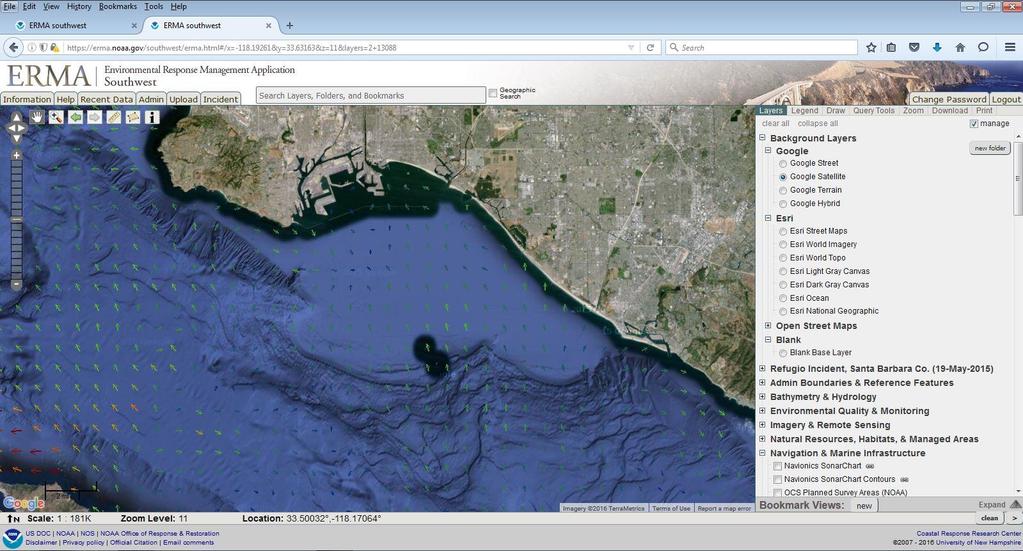
14 Environnemental Response Management Application (ERMA) Developed by NOAA (OR&R) and UNH Open Source Coding Specifically Designed as a Oil Spill Response Visualization Tool California s Southwest ERMA Valuable Planning Tool OSPR Populated W/ACP Data Layers And Provided Input for Improving Application For Spill Responders Facilitates Convergent Data Integration, with No Proprietary Software Needed for Use Provides a Common Operational Picture to all Individuals Involved in a Response
15 ERMA Southwest as a Planning Tool Marine Response OSPR Pre-Loaded ACP Data Sets Operational Divisions, SCAT Segments Environmental Sensitive Sites, Response Strategies HF Radar Inland Response Inland Surface Waters of the State UP/BNSF Rail Routes High Hazard Areas GRPs

16 ERMA Southwest - Planning Tool


17 ERMA Southwest - Planning Tool


18 ERMA Southwest - Planning Tool Marine Response - Operational Divisions
19 ERMA Southwest - Planning Tool Marine Response - SCAT Segments


20 ERMA Southwest - Planning Tool Marine Response HF Radar

21 ERMA Southwest - Planning Tool Inland Response Crude By Rail

22 ERMA Southwest - Planning Tool Reported Spill Locations,


23 ERMA Southwest - Planning Tool Inland GRPs
24 Facility Contingency Plan All Regulated Facilities, All Vessels Entering State Waters, and any Petroleum Facility Operating within ¼ Mile of Surface Waters of the State are Required to Have a Contingency Plan Internal and External Notifications Qualified Individual Spill Management Team Oil spill Response Organization (OSRO)

25 ERMA Southwest as a Planning Tool Surface Waters of the State of California
26 Emergency Response Incident Command System Esri Ocean GIS Forum, November 5-7, 2014 Redlands, California
27 USCG Incident Management Handbook August 2014 GIS is Located within the Situation Unit


28 Degree of Oiling Oiled/live Wildlife Sample Response Map Products Oiled/dead Wildlife Sampling Locations

29 Degree of Oiling


30

31 Monitoring Wells

32 Suisun Marsh Pipeline Rupture (Cleanup Status Map)

33 Base Maps

34 L L L H M L M M H Resources at Risk Overflights Bonnell Grid Aerial Wildlife Risk Assessment HUMBOLDT COUNTY L L L L L M M H L L L M L L L M M M H H H H H H L L M M H L H L M M H H L L L L M M L L M L L L L M L M L M H H M M M W N S High Risk Medium Risk Low Risk Cape Mendocino E Miles

35 Resources at Risk Overflights -Trackline Provided -Waypoints for Specific Observations
36 Mapping Spills Better and Faster Traditional Approach: Visual observations from helicopter or aircraft converted to drawing on a map using GPS. Our Approach: Easily-deployable computerized system utilizing multiple imaging channels in the visible, near-ir & thermal-ir Advantages over visual methods: 1)System is objective does not rely on opinion and experience of operator 2)Survey map is in digital GIS format allows accurate location determinations, direct computation of oil spill area and volume, etc. 3) Survey provides much greater detail Esri Ocean GIS Forum, November 5-7, 2014 Redlands, California


37 Aerial Multispectral Remote Sensing OSPR Scientific Study and Evaluation Program (SSEP)


38 Aerial Multispectral Remote Sensing

39 System test during a real oil spill case: M/V Cosco Busan, San Francisco Bay, 11/7/2007

40 Daily NOAA oil distribution map product lacked detail on exact locations of recoverable oil


41 Utilization in an Actual Spill Cosco Busan spill, 11/09/07, San Francisco Bay


42 Going Operational Technology Utilization in an Actual Spill The imaging was used on Day 1 to estimate total on-water oil and on Day 3 to Platform A spill, 12/7/08,quantity, Santa Barbara Channel document that no more recoverable oil is present and recovery operations can be suspended.


43 Analysis maps were utilized for multiple applications including: Source area oil distribution for response resource management & trajectory modeling Location of recoverable oil targets Location/extent of beached and marsh-entrained oil Effectiveness of dispersants Esri Ocean GIS Forum, November 5-7, 2014 Redlands, California

44 Model for Flow of Data from the Field and Data Management

45 Wildlife Recovery Tool

46 Wildlife Recovery Tool

47 Situational Awareness
48 Common Operational Picture A Common Operational Picture/Platform is a Data Viewer Need Software to Process the Data into GIS Format Many COPs Available; Very Simple to Very Robust Different Focuses; ICS Forms Integration, Multi-Window Dashboard Display Not Here to Say Any One is Better, All (I have interacted with) are fine Products California Uses NOAA s ERMA (Southwest) Pre-Spill Planning Tool Environmental Data Management, COP
49 Expectations for Operational Use in CA A COP Must Be Accessible to all Responders via a Network or Internet Connection A COP Must Have a Map Legend that Clearly Identifies Map Symbols Map Symbols and Terminology must be Consistent with USCG Area Contingency Plans for California. Individual Data Layers Must Have Assigned Accessibility, e.g. Responder, Public Level (TBD by the Unified Command) A COP Must Provide the Ability to individually Turn On/Off Layers Based on Login Credentials, e.g. Responder, Public A COP Should Provide the Ability to Compose and Print Simple Maps A COP Must Support Standard GIS file formats (ESRI Shapefile, KML, etc.) and Web Mapping Service Standards (WMS, ARCGIS REST, GEORSS, etc.).

50 ERMA Southwest as a COP

51 ERMA Southwest as a COP


52 ERMA Southwest as a COP Valley Incident
53 Thank You!
University of New Hampshire Scholars' Repository
 University of New Hampshire University of New Hampshire Scholars' Repository Center for Coastal and Ocean Mapping Center for Coastal and Ocean Mapping 3-2009 Environmental Response Management Application
Geographic Response Plan Mapping and Digital Area Contingency Plan
 Geographic Response Plan Mapping and Digital Area Contingency Plan Ryan Druyor Digital ACP Coordinator Florida Fish and Wildlife Conservation Commission Fish and Wildlife Research Institute Background
Coastal Response Research Center. Nancy Kinner University of New Hampshire (UNH) Michele Jacobi NOAA ORR. September 27, 2007
 Michele Jacobi NOAA ORR. September 27, 2007") Coastal Response Research Center Nancy Kinner University of New Hampshire (UNH) Michele Jacobi NOAA ORR September 27, 2007 1 Coastal Response Research Center (CRRC) CRRC is partnership between NOAA s Office
Coastal Response Research Center Nancy Kinner University of New Hampshire (UNH) Michele Jacobi NOAA ORR September 27, 2007 1 Coastal Response Research Center (CRRC) CRRC is partnership between NOAA s Office
Environmental Response Management Application
 Environmental Response Management Application Coastal Response Research Center Nancy Kinner, Michele Jacobi, Rob Braswell, Kurt Schwehr & Amy Merten RRT III May 14, 2008 1 Talk Outline Overview of Center
ASSESSMENT AND RESTORATION OF COASTAL ECOSYSTEMS USING REMOTE SENSING AND VISUALIZATION TOOLS FOR THE GULF OF MEXICO AND BEYOND
 ASSESSMENT AND RESTORATION OF COASTAL ECOSYSTEMS USING REMOTE SENSING AND VISUALIZATION TOOLS FOR THE GULF OF MEXICO AND BEYOND Remote Sensing as a Tool for Ecosystem Restoration George Graettinger Office
State-of-the-Art GIS as an Integrating Technology
 Paper # 104: GIS for Oil Spill Prevention & Response Devon Humphrey Instructor, National Spill Control School Texas A&M University at Corpus Christi, TX Introduction and History The National Spill Control
Applying Open Standards in Oil Spill Responses
 Applying Open Standards in Oil Spill Responses George Percivall, OGC Chief Engineer Bart de Lathouwer, OGC Director Interoperability Program Athina Trakas, OGC Director European Services SLC Paris 18th
Applying Open Standards in Oil Spill Responses
 Applying Open Standards in Oil Spill Responses George Percivall, OGC Chief Engineer Bart de Lathouwer, OGC Director Interoperability Program Athina Trakas, OGC Director European Services SLC Paris 18th
Extent and Degree of Shoreline Oiling: Deepwater Horizon (DWH) Oil Spill, Scott Zengel Research Planning, Inc. Tallahassee, Florida
 Oil Spill, Scott Zengel Research Planning, Inc. Tallahassee, Florida") Extent and Degree of Shoreline Oiling: Deepwater Horizon (DWH) Oil Spill, 2010 2013 Scott Zengel Research Planning, Inc. Tallahassee, Florida Background & Definitions SCAT survey data presented here SCAT
Extent and Degree of Shoreline Oiling: Deepwater Horizon (DWH) Oil Spill, 2010 2013 Scott Zengel Research Planning, Inc. Tallahassee, Florida Background & Definitions SCAT survey data presented here SCAT
IMPLEMENTING GOVERNMENT-WIDE ENTERPRISE GIS; THE FEDERATED MODEL
 IMPLEMENTING GOVERNMENT-WIDE ENTERPRISE GIS; THE FEDERATED MODEL James E. Mitchell, Ph. D. IT GIS Manager Louisiana Department of Transportation and Development presented at the ESRI International Users
Crime Analysis. GIS Solutions for Intelligence-Led Policing
 Crime Analysis GIS Solutions for Intelligence-Led Policing Applying GIS Technology to Crime Analysis Know Your Community Analyze Your Crime Use Your Advantage GIS aids crime analysis by Identifying and
Environmental Data In Support of Search & Rescue Operations in the Central Mediterranean Sea
 Environmental Data In Support of Search & Rescue Operations in the Central Mediterranean Sea Dr. Eric Comerma (RPS ASA) eric.comerma@rpsgroup.com Cathleen Turner (RPS ASA) Prof. Aldo Drago (Univ. of Malta)
ArcGIS. for Server. Understanding our World
 ArcGIS for Server Understanding our World ArcGIS for Server Create, Distribute, and Manage GIS Services You can use ArcGIS for Server to create services from your mapping and geographic information system
GIS for Integrated Pest Management. Christina Hailey. Abstract:
 GIS for Integrated Pest Management Christina Hailey Abstract: At its formation in 1965, Harris County Mosquito Control (Houston, Texas) (HCMC) was primarily involved in the prevention and control of mosquito-borne
Impact Assessment Modeling:
 Impact Assessment Modeling: robust multivariate spatial analysis tools Lucy Romeo Jen Bauer, Jake Nelson, Dori Dick, Kelly Rose ORISE Fellow & Geospatial Researcher National Energy Technology Laboratory,
Hurricane Season 2010 & NOAA s Deepwater Response
 Hurricane Season 2010 & NOAA s Deepwater Response What s Happened? What Will 2010 Bring? Possible Shoreline Effects Darin Figurskey Meteorologist-in-Charge NOAA s NWS Raleigh, NC NOAA s National Weather
Hurricane Katrina and Oil Spills: Impact on Coastal and Ocean Environments
 Archived version from NCDOCKS Institutional Repository http://libres.uncg.edu/ir/asu/ Pine, J. C. (June 2006). Hurricane Katrina and oil spills: Impact on coastal and ocean environments. Oceanography,
TOSCA RESULTS OVERVIEW
 TOSCA RESULTS OVERVIEW Almost 3 years after the project started, TOSCA has proved capable of improving oil spill tracking systems. TOSCA has brought updated knowledge on surface currents and noticeable
Journey to create opportunities in Sierra Leone using Esri s ArcGIS Platform Presented by:
 Journey to create opportunities in Sierra Leone using Esri s ArcGIS Platform Presented by: John Clark, Getech Group Plc, on behalf of The Petroleum Directorate Sierra Leone Summary The mission of the Petroleum
HOME NSGIS PORTS ENESGY DEMO CONTACT. Copyright NorthSouth GIS LLC, All rights reserved.
 The Role of Geospatial Technologies in Port Security Company NorthSouth GIS LLC Founded in 2005 Headquarters in Los Angeles Geospatial Systems Integrator An integral member of the Ports industry Esri s
Arctic Risk Map. Communicating Region s Complex Risk Picture. Øivin Aarnes Esri Petroleum GIS Conference. London, Nov. 6th DNV GL OIL & GAS
 DNV GL OIL & GAS Arctic Risk Map Communicating Region s Complex Risk Picture Øivin Aarnes Esri Petroleum GIS Conference. London, Nov. 6th. 2015 1 2015 9 November 2015 SAFER, SMARTER, GREENER DNV GL Global
Decision Support System for Oil Spill Financial Responsibility
 Decision Support System for Oil Spill Financial Responsibility Patrick R. Thorsell 1,2 1 Department of Resource Analysis, St. Mary s University of Minnesota, Winona, MN 55987, U.S.A.; 2 ACS Government
APEX 3508 MAJOR INLAND SPILL September 2, 2015 Lower Mississippi River MM 937
 APEX 3508 MAJOR INLAND SPILL September 2, 2015 Lower Mississippi River MM 937 RRT V Brief 5 NOV 2015 Sector Ohio Valley MSU Paducah Overview 469 river miles on the Ohio, Cumberland, Tennessee, and Mississippi
John Laznik 273 Delaplane Ave Newark, DE (302)
") Office Address: John Laznik 273 Delaplane Ave Newark, DE 19711 (302) 831-0479 Center for Applied Demography and Survey Research College of Human Services, Education and Public Policy University of Delaware
Office Address: John Laznik 273 Delaplane Ave Newark, DE 19711 (302) 831-0479 Center for Applied Demography and Survey Research College of Human Services, Education and Public Policy University of Delaware
Three Ways the CSU is Using Geographic Information Systems (GIS) to Inform Decisions
 to Inform Decisions") Three Ways the CSU is Using Geographic Information Systems (GIS) to Inform Decisions Diana Lavery, Senior Research Analyst California State University, Office of the Chancellor California Association of
Three Ways the CSU is Using Geographic Information Systems (GIS) to Inform Decisions Diana Lavery, Senior Research Analyst California State University, Office of the Chancellor California Association of
ArcGIS Earth for Enterprises DARRON PUSTAM ARCGIS EARTH CHRIS ANDREWS 3D
 ArcGIS Earth for Enterprises DARRON PUSTAM ARCGIS EARTH CHRIS ANDREWS 3D ArcGIS Earth is ArcGIS Earth is a lightweight globe desktop application that helps you explore any part of the world and investigate
2014 Annual Mitigation Plan Review Meeting
 2014 Annual Mitigation Plan Review Meeting Highland County EMA MEETING OBJECTIVES Understand Your Natural Disaster Risk Review of Previous Plans Current Plan Status Future Activity Plan/Needs of Each Community
Information. Information Technology. Geographic. Services (GIS) 119 W Indiana Ave Deland, FL 32720
 119 W Indiana Ave Deland, FL 32720") Information Technology Geographic Information Services (GIS) 119 W Indiana Ave Deland, FL 32720 A GIS consists of 5 primary components: Hardware Software People Data Methods or Business Processes --- Hardware
Information Technology Geographic Information Services (GIS) 119 W Indiana Ave Deland, FL 32720 A GIS consists of 5 primary components: Hardware Software People Data Methods or Business Processes --- Hardware
GIScience: Current Technology. Michael F. Goodchild University of California Santa Barbara
 GIScience: Current Technology Michael F. Goodchild University of California Santa Barbara What is a GIS? A class of software designed to handle geographic information and perform virtually any conceivable
GIS-T 2010 Building a Successful Geospatial Data Sharing Framework: A Ohio DOT Success Story
 GIS-T 2010 Building a Successful Geospatial Data Sharing Framework: A Ohio DOT Success Story ODOT District 2 GIS John Puente District 1 GIS Coordinator\ Planning Administrator 2 Interoperability 3 District
GEOGRAPHIC INFORMATION SYSTEMS Session 8
 GEOGRAPHIC INFORMATION SYSTEMS Session 8 Introduction Geography underpins all activities associated with a census Census geography is essential to plan and manage fieldwork as well as to report results
Heather Schlosser Army Corps of Engineers Coastal Studies Group August 28, 2008
 Got sand? Regional Sediment Management in Orange County Heather Schlosser Army Corps of Engineers Coastal Studies Group August 28, 2008 Regional Sediment Management Regional sediment management recognizes
The Emerging Role of Enterprise GIS in State Forest Agencies
 The Emerging Role of Enterprise GIS in State Forest Agencies Geographic Information System (GIS) A geographic information system (GIS) is a computer software system designed to capture, store, manipulate,
Alaska ShoreZone Coastal Habitat Mapping Program
 Alaska ShoreZone Coastal Habitat Mapping Program Auke Bay Laboratories Alaska Fisheries Science Center Mandy Lindeberg Coastal Issues in Alaska Resource development Coastal development Climate change Loss
Demystifying ArcGIS Online. Karen Lizcano Esri
 Demystifying ArcGIS Online Karen Lizcano Esri An Integrated Web GIS Platform Desktop Web Device Powered by Services Managed via Portal Access from any Device Portal Server Online Content and Services ArcGIS
Environmental Sensitivity to Oil Spills in Gulf Shores, AL
 1 Environmental Sensitivity to Oil Spills in Gulf Shores, AL Prepared by: Matthew Dobbertien 2 December 2011 CE 394K: GIS in Water Resources Dr. David Maidment University of Texas at Austin 1 2 Content
GIS Workshop Data Collection Techniques
 GIS Workshop Data Collection Techniques NOFNEC Conference 2016 Presented by: Matawa First Nations Management Jennifer Duncan and Charlene Wagenaar, Geomatics Technicians, Four Rivers Department QA #: FRG
Erich Gundlach, Ph.D.
 Oil Shoreline Interactions: Deepwater Horizon SETAC Boston, November 2011 Erich Gundlach, Ph.D. E-Tech International Inc. New York, USA ErichEti@ cs.com www.oil-spill-info.com What s Going On Shorelines
Leveraging Web GIS: An Introduction to the ArcGIS portal
 Leveraging Web GIS: An Introduction to the ArcGIS portal Derek Law Product Management DLaw@esri.com Agenda Web GIS pattern Product overview Installation and deployment Configuration options Security options
TRANSVERSE GIS FOR TOTAL E&P NIGERIA - GEOPS
 TRANSVERSE GIS FOR TOTAL E&P NIGERIA - GEOPS Marc Roussel / Total H. ANEKE (Manager Survey & Geomatics) J-M. AMOUROUX (Head of Geomatics and Affiliate Transverse GIS Coordinator) TEPNG/TS/ECP/Survey &
E Geographic Information System. Created By: Freda Rocker Pearl River County Mapping
 E-9-1-1 Geographic Information System Created By: Freda Rocker Pearl River County Mapping frocker@pearlrivercounty.net Overview of Pearl River County E-9-1-1 Communications District GIS In 1998 the Pearl
GIS. in the City of Lewiston Maine
 GIS in the City of Lewiston Maine The purpose of this slideshow is to provide an overview of the city GIS and how it is used, maintained and accessed in-house as well as by the public. Please simply hit
GEOGRAPHIC INFORMATION SYSTEMS AND IT SOLUTIONS FOR THE ENVIRONMENT
 GEOGRAPHIC INFORMATION SYSTEMS AND IT SOLUTIONS FOR THE ENVIRONMENT Mission We focus on Solutions is a worldwide operating business offering Geographic Information Systems and IT solutions to assist environmental
Create your own map for tidepooling, beach field trips, boating, camping, kayaking, fishing, and exploring the beaches in Southcentral Alaska.
 Create your own map for tidepooling, beach field trips, boating, camping, kayaking, fishing, and exploring the beaches in Southcentral Alaska. Here s an opportunity to download and customize your own free
Marine Spatial Planning: A Tool for Implementing Ecosystem-Based Management
 Marine Spatial Planning: A Tool for Implementing Ecosystem-Based Management Steven Murawski, Ph.D., Ecosystem Goal Team Lead National Oceanic and Atmospheric Administration NOAA November 16, 2009 1 To
ArcGIS for Desktop. ArcGIS for Desktop is the primary authoring tool for the ArcGIS platform.
 ArcGIS for Desktop ArcGIS for Desktop ArcGIS for Desktop is the primary authoring tool for the ArcGIS platform. Beyond showing your data as points on a map, ArcGIS for Desktop gives you the power to manage
The Impact of GIS Implementation on Increasing Business Efficiency
 The Impact of GIS Implementation on Increasing Business Efficiency Marko Maric Vladimir Stojanovic 1 July 15, 2014 San Diego Convention Center 2014 ESRI International User Conference Introduction GIS Implementation
Introduction to GIS. Geol 4048 Geological Applications of Remote Sensing
 Introduction to GIS Geol 4048 Geological Applications of Remote Sensing GIS History: Before Computers GIS History Using maps for a long time Dr. Roger F. Tomlinson Father of GIS He was an English geographer
Abstract. Introduction
 Southern California Aquaculture Site Assessment Model Caitlyn Raines University of Redlands Master of Science in Geographic Information Systems Program Abstract The Southern California Aquaculture Site
UNIT 4: USING ArcGIS. Instructor: Emmanuel K. Appiah-Adjei (PhD) Department of Geological Engineering KNUST, Kumasi
 Department of Geological Engineering KNUST, Kumasi") UNIT 4: USING ArcGIS Instructor: Emmanuel K. Appiah-Adjei (PhD) Department of Geological Engineering KNUST, Kumasi Getting to Know ArcGIS ArcGIS is an integrated collection of GIS software products ArcGIS
UNIT 4: USING ArcGIS Instructor: Emmanuel K. Appiah-Adjei (PhD) Department of Geological Engineering KNUST, Kumasi Getting to Know ArcGIS ArcGIS is an integrated collection of GIS software products ArcGIS
Leveraging ArcGIS Server Technology
 Leveraging ArcGIS Server Technology A Local Government Approach Virginia Johnston GIS Systems Analyst Virginia Beach 39 th Largest city in the United States 438,000 Residents City by the Sea Located in
Flood Hazard Zone Modeling for Regulation Development
 Flood Hazard Zone Modeling for Regulation Development By Greg Lang and Jared Erickson Pierce County GIS June 2003 Abstract The desire to blend current digital information with government permitting procedures,
ALASKA OCEAN OBSERVING SYSTEM 2016 ANNUAL IMPACT REPORT
 ALASKA OCEAN OBSERVING SYSTEM 2016 ANNUAL IMPACT REPORT 1 ALASKA OCEAN OBSERVING SYSTEM 2016 ANNUAL IMPACT REPORT 2 ALASKA OCEAN OBSERVING SYSTEM 2016 ANNUAL IMPACT REPORT Letter from Executive Director
IH 35 at Blanco River May 2015
 IH 35 at Blanco River May 2015 Presentation Objectives Background of historical damage assessment processes Introduction to Collector App ( Mat Peck) Collector App and Flood Damage Assessment (Katie Steele)
GIS at the Regional District
 GIS at the Regional District Amanda Spendiff Outline Introduction What is a Regional District? Our GIS department What does the GIS department do? Data management & mapping 9-1-1 fire/dispatch support
FIRE DEPARMENT SANTA CLARA COUNTY
 DEFINITION FIRE DEPARMENT SANTA CLARA COUNTY GEOGRAPHIC INFORMATION SYSTEM (GIS) ANALYST Under the direction of the Information Technology Officer, the GIS Analyst provides geo-spatial strategic planning,
QGIS FLO-2D Integration
 EPiC Series in Engineering Volume 3, 2018, Pages 1575 1583 Engineering HIC 2018. 13th International Conference on Hydroinformatics Karen O Brien, BSc. 1, Noemi Gonzalez-Ramirez, Ph. D. 1 and Fernando Nardi,
What is CERA? Coastal Emergency Risks Assessment
 What is CERA? Coastal Emergency Risks Assessment Visualization tool using OGC standards Displays the outputs from the ADCIRC storm surge model or other coastal models Represents the maps on interactive
Endangered Species Updated - December Vol. 13, No 12. Assessing the Threat of Oil Spills to Southern Sea Otters
 Endangered Species Updated - December 1996 - Vol. 13, No 12 Assessing the Threat of Oil Spills to Southern Sea Otters Michael L. Bonnell, R. Glenn Ford, and Allan J. Brody The California population of
Northrop Grumman Concept Paper
 Northrop Grumman Concept Paper A Comprehensive Geospatial Web-based Solution for NWS Impact-based Decision Support Services Glenn Higgins April 10, 2014 Northrop Grumman Corporation Information Systems
Public Awareness and Pipeline Safety
 Public Awareness and Pipeline Safety Pipeline Safety Trust November 15, 2007 Dan Kirschner Executive Director 5335 SW Meadows Rd., #220 Lake Oswego, OR 97035 (503) 624-2160 www.nwga.org NWGA Members: Avista
Alaska Natural Resource Governance
 Alaska Natural Resource Governance &SpillResponse Rutgers University Arctic Studio E.J. Bloustein School of Planning & Public Policy New Brunswick, NJ Presenting: Prof. Hal Salzman Ronit Anspach, Matt
Office of Geographic Information Systems
 Office of Geographic Information Systems Print this Page Spring 2009 - Desktop GIS: Dakota County GIS Extensions in ArcMap By Dan Castaneda In the past, the Office of GIS has created desktop extensions
Data Visualization and Evaluation
 Data Visualization and Evaluation Juan Paulo Ramírez, Ph.D. University of Nebraska 5th Annual Environmental Evaluators Networking Forum June 2010 Purpose and Objectives Purpose Introduce to program evaluators
Appendix I: Geographic Information System Data Sources
 Appendix I: Geographic Information System Data Sources Draft Environmental Impact Statement/Overseas Environmental Impact Statement Hawaii-Southern California Training and Testing TABLE OF CONTENTS...
ArcGIS Pro: Essential Workflows STUDENT EDITION
 ArcGIS Pro: Essential Workflows STUDENT EDITION Copyright 2018 Esri All rights reserved. Course version 6.0. Version release date August 2018. Printed in the United States of America. The information contained
United States Multi-Hazard Early Warning System
 United States Multi-Hazard Early Warning System Saving Lives Through Partnership Lynn Maximuk National Weather Service Director, Central Region Kansas City, Missouri America s s Weather Enterprise: Protecting
Discovery and Access of Geospatial Resources using the Geoportal Extension. Marten Hogeweg Geoportal Extension Product Manager
 Discovery and Access of Geospatial Resources using the Geoportal Extension Marten Hogeweg Geoportal Extension Product Manager DISCOVERY AND ACCESS USING THE GEOPORTAL EXTENSION Geospatial Data Is Very
How does ArcGIS Server integrate into an Enterprise Environment? Willy Lynch Mining Industry Specialist ESRI, Denver, Colorado USA
 How does ArcGIS Server integrate into an Enterprise Environment? Willy Lynch Mining Industry Specialist ESRI, Denver, Colorado USA wlynch@esri.com ArcGIS Server Technology Transfer 1 Agenda Who is ESRI?
Chapter 1 Overview of Maps
 Chapter 1 Overview of Maps In this chapter you will learn about: Key points when working with maps General types of maps Incident specific maps Map legend and symbols Map sources A map is a navigational
Key Points Sharing fosters participation and collaboration Metadata has a big role in sharing Sharing is not always easy
 Sharing Resources Geoff Mortson esri, Inc. SDI Solutions Team Key Points Sharing fosters participation and collaboration Metadata has a big role in sharing Sharing is not always easy Data Sharing is Good
OC Public Works El Niño Storm Preparation 2015
 OC Public Works El Niño Storm Preparation 2015 December 8, 2015 Overview About OC Public Works Storm Preparation Pre-Storm During Storm Post-Storm Storm Preparation Canyon and Burn Areas County Department
LRS Task Force June 13, REVISION HISTORY
 North Carolina Department of Transportation Geographic Information Systems (GIS) Unit LINEAR REFERENCING SYSTEM (LRS) PROJECT DEFINITION Version 1.0 REVISION HISTORY Date Document Manager Revision Purpose
You are Building Your Organization s Geographic Knowledge
 You are Building Your Organization s Geographic Knowledge And Increasingly Making it Available Sharing Data Publishing Maps and Geo-Apps Developing Collaborative Approaches Citizens Knowledge Workers Analysts
A New National Flood Inundation Mapping Science Initiative
 A New National Flood Inundation Mapping Science Initiative William Guertal, PhD. Director, USGS Indiana and Kentucky Water Science Centers U.S. Department of the Interior U.S. Geological Survey Courtesy
GNOME Oil Spill Modeling Lab
 GNOME Oil Spill Modeling Lab Name: Goal: After simulating an actual oil spill event, you will understand how oceanographers help to protect marine resources from pollution such as oil spills. You will
Export Basemap Imagery from GIS to CAD
 Export Basemap Imagery from GIS to CAD This tutorial illustrates how to add high resolution imagery as a basemap into an existing CAD drawing using ArcGIS and AutoCAD. Through this method, the imagery
HISTORY OF GIS AND ESRI
 HISTORY OF GIS AND ESRI First Developed by Dr. Roger Tomlinson in Canada 1960 (CGIS Canadian geographic system) The system was designed to inventory land use and assist in the management of natural resources
A Summary of State DOT GIS Activities. Presented at the 2000 AASHTO GIS-T Symposium Minneapolis, MN
 A Summary of State DOT GIS Activities Presented at the 2000 AASHTO GIS-T Symposium Minneapolis, MN Information Sources E-mail survey of state DOT GIS managers 49 State DOTs responded in 2000 Results compared
Marine Spatial Planning, a Norwegian user case NSHC33
 Marine Spatial Planning, a Norwegian user case NSHC33 Marine Spatial Management Tool Support the marine spatial planning process with updated and reliable geospatial information Marine management is important
Integrating GIS into West Nile Virus Planning and Surveillance
 Integrating GIS into West Nile Virus Planning and Surveillance Fairfax County Health Department Adrian Joye, Environmental Health Specialist Agenda Background/Benefits Routes/Trap Locations Dead Bird Complaint
Spatial Analysis with Web GIS. Rachel Weeden
 Spatial Analysis with Web GIS Rachel Weeden Agenda Subhead goes here Introducing ArcGIS Online Spatial Analysis Workflows Scenarios Other Options Resources ArcGIS is a Platform Making mapping and analytics
Climate Risk Visualization for Adaptation Planning and Emergency Response
 Climate Risk Visualization for Adaptation Planning and Emergency Response NCR Flood Fact Finding Workshop Ricardo Saavedra ricardo@vizonomy.com Social Media, Mobile, and Big Data St. Peter s Basilica,
Introducing the. a partnership of
 Introducing the a partnership of Background Need for online atlas identified by managers and researchers to make coastal data available Shoreline data Ocean and coastal resources Sea-level rise potential
Sea Level Rise and the Public Trust Doctrine:
 Sea Level Rise and the Public Trust Doctrine: Meeting Coastal Governance Challenges in the Face of Climate Change www.remote.ucdavis.edu Department ofwater Resources www.rwongphoto.com Jennifer DeLeon
United States Forest Service Makes Use of Avenza PDF Maps App to Reduce Critical Time Delays and Increase Response Time During Natural Disasters
 CASE STUDY For more information, please contact: Christine Simmons LFPR Public Relations www.lfpr.com (for Avenza) 949.502-7750 ext. 270 Christines@lf-pr.com United States Forest Service Makes Use of Avenza
Remote Sensing and Incident Support. Department of Homeland Security February 22, 2013
 Remote Sensing and Incident Support Department of Homeland Security February 22, 2013 Introductions and Goals Today s Webcast will be Presented by: Chris Barnard DHS Remote Sensing Advisor Chris Vaughan
3Chapter Three: Rescue and Response
 17 16 Report Science Title and the Storms: the USGS Response to the Hurricanes of 2005 3Chapter Three: Rescue and Response This chapter documents the U.S. Geological Survey s (USGS) humanitarian rescue
National / Naval Ice Center (NIC) Operations Brief This brief is UNCLASSIFIED
 Operations Brief This brief is UNCLASSIFIED") National / Naval Ice Center (NIC) Operations Brief This brief is UNCLASSIFIED Christopher Szorc, Senior Ice Analyst/Forecaster USCG USN NOAA Outline NIC s mission is to provide timely, accurate and relevant
National / Naval Ice Center (NIC) Operations Brief This brief is UNCLASSIFIED Christopher Szorc, Senior Ice Analyst/Forecaster USCG USN NOAA Outline NIC s mission is to provide timely, accurate and relevant
6TH ANNUAL BUILDING EMERGENCY PLAN SUMMIT
 CAMPUS EMERGENCY PREPAREDNESS TRAINING SERIES 6TH ANNUAL BUILDING EMERGENCY PLAN SUMMIT Ron Wright, Director Jefferson Howells, Asst Director Campus Emergency Preparedness & Planning Office 205 South Martin
GIS for Crime Analysis. Building Better Analysis Capabilities with the ArcGIS Platform
 GIS for Crime Analysis Building Better Analysis Capabilities with the ArcGIS Platform Crime Analysis The Current State One of the foundations of criminological theory is that three things are needed for
Geospatial Decision Support Tools for Planning of Marine Protected Areas in California
 Geospatial Decision Support Tools for Planning of Marine Protected Areas in California WILL MCCLINTOCK (UNIVERSITY OF CALIFORNIA SANTA BARBARA), MATT MERRIFIELD (THE NATURE CONSERVANCY), SOPHIE DE BEUKELAER
Introduction to ArcGIS Server - Creating and Using GIS Services. Mark Ho Instructor Washington, DC
 Introduction to ArcGIS Server - Creating and Using GIS Services Mark Ho Instructor Washington, DC Technical Workshop Road Map Product overview Building server applications GIS services Developer Help resources
2018 NASCIO Award Submission Category: Cross-Boundary Collaboration and Partnerships. Project Title: Tennessee Wildfires: A Coordinated GIS Response
 2018 NASCIO Award Submission Category: Cross-Boundary Collaboration and Partnerships Project Title: Tennessee Wildfires: A Coordinated GIS Response Sevier County, Tennessee State of Tennessee, Emergency
GENERALIZATION IN THE NEW GENERATION OF GIS. Dan Lee ESRI, Inc. 380 New York Street Redlands, CA USA Fax:
 GENERALIZATION IN THE NEW GENERATION OF GIS Dan Lee ESRI, Inc. 380 New York Street Redlands, CA 92373 USA dlee@esri.com Fax: 909-793-5953 Abstract In the research and development of automated map generalization,
Application of Geospatial Technology in an Emergency Management Academic Program
 Application of Geospatial Technology in an Emergency Management Academic Program Author Edwin Leachman Visiting Assistant Professor Department of Emergency Administration and Management Arkansas Tech University
12/2/15. Providing observa.ons, data and informa.on products to meet agency and stakeholder needs
 12/2/15 Providing observa.ons, data and informa.on products to meet agency and stakeholder needs 1 Part of the Integrated Ocean Observing System (IOOS) Governed through a Memorandum of Agreement Fiscal
June 19 Huntsville, Alabama 1
 June 19 Huntsville, Alabama 1 Real-Time Geospatial Data: The Fusion of PI and ArcGIS Enabling Smarter Facilities Management OSIsoft and Esri Mapping and Location Analytics Platform Supporting Your Use
Mapping Climate Change in a Yupik Eskimo Village
 Mapping Climate Change in a Yupik Eskimo Village Stephen C. Brown, Ph.D. University of Alaska Fairbanks Cooperative Extension Service scbrown4@alaska.edu Terence Reeve University of Alaska Fairbanks Marine
SAFMC Habitat and Ecosystem IMS. Habitat and Environmental Protection Advisory Panel Meeting
 SAFMC Habitat and Ecosystem IMS Habitat and Environmental Protection Advisory Panel Meeting Charleston, SC November 18, 2008 Project Overview Phase 1 develop and host an Internet Map Server (IMS) application