A New National Flood Inundation Mapping Science Initiative
|
|
|
- Anne Haynes
- 5 years ago
- Views:
Transcription

1 A New National Flood Inundation Mapping Science Initiative William Guertal, PhD. Director, USGS Indiana and Kentucky Water Science Centers U.S. Department of the Interior U.S. Geological Survey

2 Courtesy of Louisiana Digital Map Library:


3 From the 19 th to the 21 st century Old concept, new technology: Leveraging Evolving Technologies LiDAR- DEMs GIS World Wide Web 2D hydraulic models Real-time and forecast hydrologic data FEMA s HAZUS-MH

4 NWS Assessment Team Team comprised of NWS, USACE, USGS members Report contains a number of findings & recommendations to improve customer service

5 Key Findings & Recommendations Finding 28: Flood inundation mapping will help the public, media, emergency managers, and others visualize the spatial extent and depth of flood waters in the vicinity of NWS river forecast locations. Recommendation 28: The NWS should expand efforts with state and federal agencies and others to accelerate the implementation of flood inundation mapping across the United States.


6 Inundation Mapping becomes a tool for flood. Preparedness What-if scenarios Response Tied to gage & forecast data Recovery Damage assessment e.g. HAZUS-MH Mitigation & planning Flood risk analyses

7 New USGS Flood Inundation Mapping Initiative (FIMI) FIMI will develop a comprehensive and program designed to meet USGS science strategy goals related to natural hazards and stakeholder needs. Important stakeholders are those who use HAZUS-MH for flood-loss estimations.
8 Goals and Objectives 1. Develop a consistent visual and electronic format for USGS inundation map products. 2. Develop a National USGS FIMI Web portal 3. Produce static flood inundation map libraries linked to gages/flood forecasts 4. Develop state-of-the art dynamic, real-time flood inundation applications 5. Develop a core of USGS and partner agencies


9 USGS FIMI Focus Areas 1. Flood Studies 2. Static inundation map libraries 3. Real-time, dynamic applications


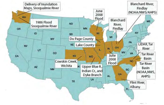
10 Flood Studies FEMA funded Many partners Report template OFR/SIR Flood magnitudes Peak profiles and inundation maps

11 PDF and GIS file formats


12 NWS AHPS: Advanced Hydrologic Prediction Service Forecast stage at flood forecast points Collocated at gages

13 AHPS Library, Findlay, OH


14 Dynamic Applications Mines USGS/NWS data Hydraulic model run on-the-fly Responds to changing gage & forecast info Outputs RT & predicted maps Ultimate destination for FIMI

15 Real-time inundation mapping IN Silver Jackets Pilot Project 11-mile reach of White River, Indianapolis Tied to streamgage/flood forecast point Partnering with POLIS Center Funding City of Indianapolis IDHS USGS Indianapolis Museum of Art

16 SOA Service Oriented Architecture Allows different applications to exchange data with one another. Products/services based on interoperability of independent & distributed applications.


17 Parcel & HAZUS Data Service Parcel Data FASTMECH Calibration Loss Estimate FastMech runs on IU s Big Red Flood Depth Grid Data Loss Calculation Process Flood Map Real-time USGS gage and NWS flood forecast data Maps and Reports
18
19 Web Portal - Goals Develop a National USGS Web portal to display existing and future FIMI products Single point of entry for users Present a common look and feel to products with varying levels of technical difficulty Export products to FEMA and NWS Login access for EMA officials Will have high-speed mapping viewer

20 Web Portal
21 Summary and Conclusions Inundation maps + RT/forecast data = powerful new tool for flood loss reduction Partnerships make it possible Highly expandable in scope and scale Coastal inundation/hurricanes SOA = expandability & future potential Public flood education/ outreach Travel-time spill applications Levee & dam breach applications Great tool/resource to use with HAZUS
22 Questions?
Flood Inundation Mapping
 KU GIS Day 2009 November 18, 2009 Flood Inundation Mapping Wendy L. Pearson NOAA s National Weather Service Central Region Headquarters Kansas City, Missouri Flood Inundation Mapping Objectives: Overview
Rainfall-River Forecasting: Overview of NOAA s Role, Responsibilities, and Services
 Dr. Thomas Graziano Chief Hydrologic Services Division NWS Headquarters Steve Buan Service Coordination Hydrologist NWS North Central River Forecast Center Rainfall-River Forecasting: Overview of NOAA
Floodplain Mapping & Flood Warning Applications in North Carolina
 Floodplain Mapping & Flood Warning Applications in North Carolina Marc Stanard, IT Project Manager Ken Ashe, Assistant Director David Herlong, Flood Warning Program Manager NC Crime Control & Public Safety
Arkansas-Red Basin River Forecast Center Operations. RRVA Conference Durant, OK 8/22/2013 Jeff McMurphy Sr. Hydrologist - ABRFC
 Arkansas-Red Basin River Forecast Center Operations RRVA Conference Durant, OK 8/22/2013 Jeff McMurphy Sr. Hydrologist - ABRFC NWS River Forecast Centers NWS Weather Forecast Offices Operations Staffing
United States Multi-Hazard Early Warning System
 United States Multi-Hazard Early Warning System Saving Lives Through Partnership Lynn Maximuk National Weather Service Director, Central Region Kansas City, Missouri America s s Weather Enterprise: Protecting
USGS Flood Inundation Mapping of the Suncook River in Chichester, Epsom, Pembroke and Allenstown, New Hampshire
 USGS Flood Inundation Mapping of the Suncook River in Chichester, Epsom, Pembroke and Allenstown, New Hampshire NH Water & Watershed Conference Robert Flynn, USGS NH-VT Water Science Center March 23, 2012
HEC & GIS Modeling of the Brushy Creek HEC & GIS Watershed Modeling of the
 HEC & GIS Modeling of the Brushy Creek HEC & GIS Watershed Modeling of the By Cassandra Fagan 5, December 2014 http://ubcwatershedstudy.ursokr.com/images/ Contents Introduction... 3 Figure 1: 24-hour rainfall
Real-Time Flood Forecasting Modeling in Nashville, TN utilizing HEC-RTS
 Real-Time Flood Forecasting Modeling in Nashville, TN utilizing HEC-RTS Brantley Thames, P.E. Hydraulic Engineer, Water Resources Section Nashville District, USACE August 24, 2017 US Army Corps of Engineers
NOAA s National Weather Service. National Weather Service
 NOAA s National Weather Service Serving the Nation s Environmental Forecasting Needs Lynn Maximuk Regional Director National Weather Service Central Region Headquarters Kansas City, Missouri America s
3D Elevation Program, Lidar in Missouri. West Central Regional Advanced LiDAR Workshop Ray Fox
 3D Elevation Program, Lidar in Missouri West Central Regional Advanced LiDAR Workshop Ray Fox National Enhanced Elevation Assessment (Dewberry, 2011) Sponsored by the National Digital Elevation Program
Pequabuck River Flooding Study and Flood Mitigation Plan The City of Bristol and Towns of Plainville and Plymouth, CT
 Pequabuck River Flooding Study and Flood Mitigation Plan The City of Bristol and Towns of Plainville and Plymouth, CT Raymond Rogozinski and Maged Aboelata The City of Bristol and Towns of Plainville and
3Chapter Three: Rescue and Response
 17 16 Report Science Title and the Storms: the USGS Response to the Hurricanes of 2005 3Chapter Three: Rescue and Response This chapter documents the U.S. Geological Survey s (USGS) humanitarian rescue
Storm Surge Analysis Update Meeting Cross City, Florida June 17, 2014
 Big Bend Coastal Storm Surge Study Storm Surge Analysis Update Meeting Cross City, Florida June 17, 2014 Introductions Risk MAP Project Team FEMA Region IV Florida Division of Emergency Management (FDEM)
Climate Risk Visualization for Adaptation Planning and Emergency Response
 Climate Risk Visualization for Adaptation Planning and Emergency Response NCR Flood Fact Finding Workshop Ricardo Saavedra ricardo@vizonomy.com Social Media, Mobile, and Big Data St. Peter s Basilica,
Summary of Available Datasets that are Relevant to Flood Risk Characterization
 Inter-Agency Characterization Workshop February 25-27, 2014 USACE Institute for Water Resources, Alexandria, VA, IWR Classroom Summary of Available Datasets that are Relevant to Characterization National
MISSOURI LiDAR Stakeholders Meeting
 MISSOURI LiDAR Stakeholders Meeting East-West Gateway June 18, 2010 Tim Haithcoat Missouri GIO Enhanced Elevation Data What s different about it? Business requirements are changing.fast New data collection
Adaptation to Sea Level Rise A Regional Approach
 Adaptation to Sea Level Rise A Regional Approach Project Partners: in Saco Bay, ME Peter Slovinsky, Marine Geologist Maine Geological Survey, Department of Conservation Project Funding from: Saco Bay Hazards
DEPARTMENT OF GEOLOGY AND MINERAL INDUSTRIES WAYS & MEANS SUBCOMMITTEE ON NATURAL RESOURCES MARCH 2, 2017
 DEPARTMENT OF GEOLOGY AND MINERAL INDUSTRIES WAYS & MEANS SUBCOMMITTEE ON NATURAL RESOURCES MARCH 2, 2017 1 ABOUT DOGAMI AGENCY MISSION, VISION & GOALS 2 Lidar image of a stream network along the Umpqua
Doug Kluck NOAA Kansas City, MO National Center for Environmental Information (NCEI) National Integrated Drought Information System (NIDIS)
 National Integrated Drought Information System (NIDIS)") National Integrated Drought Information System (NIDIS) for the Missouri River Basin Drought Early Warning Information System (DEWS) & Runoff Trends in the Missouri Basin & Latest Flood Outlook Doug Kluck
National Integrated Drought Information System (NIDIS) for the Missouri River Basin Drought Early Warning Information System (DEWS) & Runoff Trends in the Missouri Basin & Latest Flood Outlook Doug Kluck
Positioning the Pacific: NOAA s Geospatial Activities. Juliana Blackwell, Director NOAA s National Geodetic Survey March 6, 2012
 Positioning the Pacific: NOAA s Geospatial Activities Juliana Blackwell, Director NOAA s National Geodetic Survey March 6, 2012 A Common Problem of the Early 19 th Century 1807 President Thomas Jefferson
Layers (Layers in italics indicate group layers.) MyHazards MyPlan* Floods and Drought Landslides - USGS
 MyHazards MyPlan* Floods and Drought Landslides - USGS") MyHazards and MyPlan WebApps for Nevada Geohazards Over 100 hazard layers related to floods, fires, earthquakes, radon, and other supporting reference layers. Powerful educational and decision-making tools
MyHazards and MyPlan WebApps for Nevada Geohazards Over 100 hazard layers related to floods, fires, earthquakes, radon, and other supporting reference layers. Powerful educational and decision-making tools
San Antonio River Authority. San Antonio River Authority Floodworks implementation in the San Antonio River Basin. Nefi Garza, PE, CFM
 San Antonio River Authority Floodworks implementation in the San Antonio River Basin Nefi Garza, PE, CFM San Antonio River Authority Michael Crenshaw, PE, CFM Anthony J. Henry Wallingford Software, Inc
USGS Hydrography Overview. May 9, 2018
 + 1 USGS Hydrography Overview May 9, 2018 + 2 The National Geospatial Program Provides the geospatial baseline of the Nation s topography, natural landscape and built environment through The National Map,
Base Level Engineering FEMA Region 6
 Base Level Engineering Over the past five years, has been evaluating its investment approach and data preparation work flow to establish an efficient and effective change in operation, generating an approach
Office of Technology Partnerships GIS Collaboration
 Office of Technology Partnerships GIS Collaboration State GIS Update April 21, 2017 Mark Holmes, GISP Outline MGF Upgrade Project Census Programs Imagery Update LiDAR Update Open Discussion 2 MGF Background
Out with the Old, In with the New: Implementing the Results of the Iowa Rapid Floodplain Modeling Project
 Out with the Old, In with the New: Implementing the Results of the Iowa Rapid Floodplain Modeling Project Traci Tylski, E.I., CFM Hydraulics Engineer USACE - Omaha District Traci.M.Tylski@USACE.army.mil
USGS National Geospatial Program Understanding User Needs. Dick Vraga National Map Liaison for Federal Agencies July 2015
 + USGS National Geospatial Program Understanding User Needs Dick Vraga National Map Liaison for Federal Agencies July 2015 + Topics 2 Background Communities of Use User Surveys National Map Liaisons Partnerships
Development of a Fluvial Erosion Hazard Mitigation Program for Indiana
 Development of a Fluvial Erosion Hazard Mitigation Program for Indiana Indiana Watersheds Webinar Series October 12,2011 Robert Barr Center for Earth and Environmental Science Department of Earth Sciences
Flood Hazard Inundation Mapping. Presentation. Flood Hazard Mapping
 Flood Hazard Inundation Mapping Verne Schneider, James Verdin, and JeradBales U.S. Geological Survey Reston, VA Presentation Flood Hazard Mapping Requirements Practice in the United States Real Time Inundation
Document Title. Estimating the Value of Partner Contributions to Flood Mapping Projects. Blue Book
 Document Title Estimating the Value of Partner Contributions to Flood Mapping Projects Blue Book Version 1.1 November 2006 Table of Contents 1. Background...1 2. Purpose...1 3. Overview of Approach...2
Smart Flood Risk Management Solutions
 Smart Flood Risk Management Solutions - RHDHV s Experience in the Gulf of Mexico Mathijs van Ledden, Marten Hillen and Ries Kluskens Challenge Extreme weather around the world (hurricanes, cyclones, extratropical
State-of-the-Art GIS as an Integrating Technology
 Paper # 104: GIS for Oil Spill Prevention & Response Devon Humphrey Instructor, National Spill Control School Texas A&M University at Corpus Christi, TX Introduction and History The National Spill Control
An Overview of Operations at the West Gulf River Forecast Center Gregory Waller Service Coordination Hydrologist NWS - West Gulf River Forecast Center
 National Weather Service West Gulf River Forecast Center An Overview of Operations at the West Gulf River Forecast Center Gregory Waller Service Coordination Hydrologist NWS - West Gulf River Forecast
Borah Peak Earthquake HAZUS Scenario Project Executive Summary Idaho Bureau of Homeland Security Idaho Geological Survey Western States Seismic
 Borah Peak Earthquake HAZUS Scenario Project Executive Summary Idaho Bureau of Homeland Security Idaho Geological Survey Western States Seismic Policy Council 12/30/2008 The HAZUS-MH analysis of the Borah
B.2 Sources for Hazard Identification, Profiling, and Ranking (Section 3) Overview of Sussex County s History of Hazards
 Overview of Sussex County s History of Hazards") Appendix B Sources B.1 Sources for Planning Process (Section 2) FEMA. Mitigation Planning Guidance (386 Series). Available on the web at: http://www.fema.gov/plan/mitplanning/planning_resources.shtm FEMA
Appendix B Sources B.1 Sources for Planning Process (Section 2) FEMA. Mitigation Planning Guidance (386 Series). Available on the web at: http://www.fema.gov/plan/mitplanning/planning_resources.shtm FEMA
Flooding Performance Indicator Summary. Performance indicator: Flooding impacts on riparian property for Lake Ontario and the Upper St.
 Flooding Performance Indicator Summary Performance indicator: Flooding impacts on riparian property for Lake Ontario and the Upper St. Lawrence River Technical Workgroup: Coastal TWG Research by: Baird
CERA-Atlantic Storm Surge Web Page: Improvements for 2013 Based on EM Feedback
 CERA-Atlantic Storm Surge Web Page: Improvements for 2013 Based on EM Feedback Jessica Losego Meteorologist University of North Carolina - Institute for the Environment Rick Luettich Director, UNC IMS
HAZUS-MH: A Predictable Hurricane Risk Assessment Tool for the City of Houston and Harris County
 HAZUS-MH: A Predictable Hurricane Risk Assessment Tool for the City of Houston and Harris County Presented by Melvin G. Spinks, P.E., President Annie Ding, PhD, GISP October 29, 2008 Rice University Contents
NOAA S2S Planning. Dave DeWitt Fred Toepfer
 NOAA S2S Planning Dave DeWitt Fred Toepfer 1 Agenda 1. Brief synopsis of The Weather Research and Forecasting Act of 2017 2. Report to Congress a. Timeline b. Process c. Document Outline 3. Some Preliminary
What s New in Topographic Information - USGS National Map
 + What s New in Topographic Information - USGS National Map SARGIS Workshop November 14, 2016 Rob Dollison, 703-648-5724 rdollison@usgs.gov + USGS 2 National Geospatial Program The National Geospatial
Semester Project Final Report. Logan River Flood Plain Analysis Using ArcGIS, HEC-GeoRAS, and HEC-RAS
 Semester Project Final Report Logan River Flood Plain Analysis Using ArcGIS, HEC-GeoRAS, and HEC-RAS Kedric Curtis, Josh Hogge, Jordan Jarrett, Jared Justensen May 6, 2016 CEE 6190 GIS for Civil Engineers
North Carolina Simplified Inundation Maps For Emergency Action Plans December 2010; revised September 2014; revised April 2015
 North Carolina Simplified Inundation Maps For Emergency Action Plans December 2010; revised September 2014; revised April 2015 INTRODUCTION Emergency Action Plans (EAPs) are critical to reducing the risks
DOWNLOAD OR READ : GIS BASED FLOOD LOSS ESTIMATION MODELING IN JAPAN PDF EBOOK EPUB MOBI
 DOWNLOAD OR READ : GIS BASED FLOOD LOSS ESTIMATION MODELING IN JAPAN PDF EBOOK EPUB MOBI Page 1 Page 2 gis based flood loss estimation modeling in japan gis based flood loss pdf gis based flood loss estimation
Humanitarian Assistance and Disaster Relief (HADR)
") Humanitarian Assistance and Disaster Relief (HADR) Remote sensing, GIS & Server Technology for Planning, Response & Mitigation Jonathan Lee Hon Yip Senior Technical Sales, Intergraph Security, Government
Humanitarian Assistance and Disaster Relief (HADR) Remote sensing, GIS & Server Technology for Planning, Response & Mitigation Jonathan Lee Hon Yip Senior Technical Sales, Intergraph Security, Government
Interpretive Map Series 24
 Oregon Department of Geology and Mineral Industries Interpretive Map Series 24 Geologic Hazards, and Hazard Maps, and Future Damage Estimates for Six Counties in the Mid/Southern Willamette Valley Including
LOMR SUBMITTAL LOWER NESTUCCA RIVER TILLAMOOK COUNTY, OREGON
 LOMR SUBMITTAL LOWER NESTUCCA RIVER TILLAMOOK COUNTY, OREGON Prepared for: TILLAMOOK COUNTY DEPARTMENT OF COMMUNITY DEVELOPMENT 1510-B THIRD STREET TILLAMOOK, OR 97141 Prepared by: 10300 SW GREENBURG ROAD,
IDENTIFICATION OF HAZARDS OF CONCERN
 IDENTIFICATION OF HAZARDS OF CONCERN To provide a strong foundation for mitigation strategies considered in Section 6, the Village considered a full range of hazards that could impact the area and then
Coastal Response Research Center. Nancy Kinner University of New Hampshire (UNH) Michele Jacobi NOAA ORR. September 27, 2007
 Michele Jacobi NOAA ORR. September 27, 2007") Coastal Response Research Center Nancy Kinner University of New Hampshire (UNH) Michele Jacobi NOAA ORR September 27, 2007 1 Coastal Response Research Center (CRRC) CRRC is partnership between NOAA s Office
Coastal Response Research Center Nancy Kinner University of New Hampshire (UNH) Michele Jacobi NOAA ORR September 27, 2007 1 Coastal Response Research Center (CRRC) CRRC is partnership between NOAA s Office
The 3D Elevation Program: Overview. Jason Stoker USGS National Geospatial Program ESRI 2015 UC
 + The 3D Elevation Program: Overview Jason Stoker USGS National Geospatial Program ESRI 2015 UC + 2 A little history USGS has a long, proud tradition of mapmaking (2009) + 3 The changing times Mapping
Lake Champlain Richelieu River Flood Inundation Mapping and Forecasting Tool
 Lake Champlain Richelieu River Flood Inundation Mapping and Forecasting Tool Rob Flynn USGS New England Water Science Center, NH/VT Office U.S. Department of the Interior U.S. Geological Survey Lake Champlain
The Kentucky Mesonet: Entering a New Phase
 The Kentucky Mesonet: Entering a New Phase Stuart A. Foster State Climatologist Kentucky Climate Center Western Kentucky University KCJEA Winter Conference Lexington, Kentucky February 9, 2017 Kentucky
National Flood Interoperability Experiment
 National Flood Interoperability Experiment David R. Maidment, University of Texas at Austin Catchment-based Hydrological Data Assimilation (CAHMDA) VI Conference 8 September 2014 Located on Tuscaloosa
Seth J. Wittke Wyoming State Geological Survey
 Seth J. Wittke Wyoming State Geological Survey Project initiation Data manipulation Scenarios Creating the IMS Lessons learned County-wide block level probabilistic models created in 2004 for state mitigation
WESTERN STATES SEISMIC POLICY COUNCIL POLICY RECOMMENDATION Earthquake and Tsunami Planning Scenarios
 WESTERN STATES SEISMIC POLICY COUNCIL POLICY RECOMMENDATION 18-1 Earthquake and Tsunami Planning Scenarios Policy Recommendation 18-1 WSSPC strongly encourages states, provinces, territories, First Nations,
FEMA Hazards Loss Modeling Task Force (MOTF) Situation Report #14. Colorado Spring Flood Risk ***FINAL REPORT***
 Situation Report #14. Colorado Spring Flood Risk ***FINAL REPORT***") FEMA Hazards Loss Modeling Task Force (MOTF) Situation Report #14 Colorado Spring Flood Risk FEMA Modeling Task Force (MOTF) Denver Federal Center, Building 710A Denver, Colorado 80225 Email: FEMA-MOTF@fema.dhs.gov
FEMA Hazards Loss Modeling Task Force (MOTF) Situation Report #14 Colorado Spring Flood Risk FEMA Modeling Task Force (MOTF) Denver Federal Center, Building 710A Denver, Colorado 80225 Email: FEMA-MOTF@fema.dhs.gov
The Indiana Data Sharing Initiative and the IndianaMap. Cross-Boundary Collaboration and Partnerships. State of Indiana
 The Indiana Data Sharing Initiative and the IndianaMap Cross-Boundary Collaboration and Partnerships State of Indiana Brian Arrowood, CIO James Sparks, GIO EXECUTIVE SUMMARY Under the collaboration oriented
Preliminary Vulnerability Assessment of Coastal Flooding Threats - Taylor County, Florida
 Preliminary Vulnerability Assessment of Coastal Flooding Threats - Taylor County, Florida North Central Florida Regional Planning Council Northeast Florida Regional Council April 28, 2016 BACKGROUND This
Nurture Nature Center Receives Grant From National Oceanic and Atmospheric Administration To Study Flood Forecast and Warning Tools
 Nurture Nature Center Receives Grant From National Oceanic and Atmospheric Administration To Study Flood Forecast and Warning Tools One of four national awards by National Weather Service to advance weather
Using NFHL Data for Hazus Flood Hazard Analysis: An Exploratory Study
 Andrea M. Jackman, Ph.D. ASFPM June 3, 2015 Using NFHL Data for Hazus Flood Hazard Analysis: An Exploratory Study What is Hazus? Hazus is FREE software distributed by FEMA Risk MAP which models structural
TRB First International Conference on Surface Transportation Resilience
 TRB First International Conference on Surface Transportation Resilience Applying the Sea-Level Scenario Sketch Planning Tool to Enhance the Resilience of Long-Range Transportation Plans: Lessons Learned
Emergency Alerting Policy NOAA s National Weather Service
 Emergency Alerting Policy NOAA s National Weather Service OASIS, ITU, WMO, Environment Canada, Public Safety Canada, Centre for Security Sciences (Canada) Common Alerting Protocol (CAP) Emergency Alerting
Storm Surge/Coastal Inundation State of the Union. Jamie Rhome Storm Surge Team Lead NOAA/National Hurricane Center
 Storm Surge/Coastal Inundation State of the Union Jamie Rhome Storm Surge Team Lead NOAA/National Hurricane Center 2 Tampa: Cat 5 Scenario 3 4 The Stakes are High Combination of SLR and increasing coastal
Colorado Ice Jams and CRREL s Ice Jam Database CRREL Ice Engineering Group
 Colorado Ice Jams and CRREL s Ice Jam Database CRREL Ice Engineering Group Presented by, Carrie Vuyovich, Ph.D., P.E. Research Hydraulic Engineer ERDC Cold Regions Research and Engineering Laboratory,
CITY OF RIVERSIDE USING HAZUS TO CREATE A EARTHQUAKE PLANNING GUIDE FOR A UNIFIED FIELD RESPONSE
 CITY OF RIVERSIDE USING HAZUS TO CREATE A EARTHQUAKE PLANNING GUIDE FOR A UNIFIED FIELD RESPONSE Presented by the Phil McCormick City of Riverside Office of Emergency Management HISTORY The City had several
Northrop Grumman Concept Paper
 Northrop Grumman Concept Paper A Comprehensive Geospatial Web-based Solution for NWS Impact-based Decision Support Services Glenn Higgins April 10, 2014 Northrop Grumman Corporation Information Systems
Sea level rise Web GIS Applications
 Florida International University FIU Digital Commons GIS Center GIS Center 2018 Sea level rise Web GIS Applications Zhaohui Fu GIS-RS Center, Florida International University, Fujen@fiu.edu Sheyla Santana
Kentucky Collaborates in GeoMAPP Project: The Advantages and Challenges of Archiving in a State with a Centralized GIS
 Kentucky Collaborates in GeoMAPP Project: The Advantages and Challenges of Archiving in a State with a Centralized GIS Geospatial Multistate Archive and Preservation Partnership By Glen McAninch Best Practices
Developing Web-Based Hydrologic Decision Support Services
 Developing Web-Based Hydrologic Decision Support Services Paul McKee NOAA/National Weather Service West Gulf River Forecast Center Tracy Clark, Corey Pieper NWS Southern Region Greg Shelton NWS, detailed
From Vulnerability to Resilience And the Tools to Get There. Out of Harm s Way Partnership for the Delaware Estuary August 1, 2012
 From Vulnerability to Resilience And the Tools to Get There Out of Harm s Way Partnership for the Delaware Estuary August 1, 2012 Today s Presentation Tour of New Jersey Challenges Definitions so we re
WMO Public Weather Services: Enhanced Communication Skills for Improved Service Delivery. by S.W. Muchemi (WMO)
") WMO Public Weather Services: Enhanced Communication Skills for Improved Service Delivery by S.W. Muchemi (WMO) Functions of the Public Weather Services (PWS) programme of WMO To strengthen the capabilities
WMO Public Weather Services: Enhanced Communication Skills for Improved Service Delivery by S.W. Muchemi (WMO) Functions of the Public Weather Services (PWS) programme of WMO To strengthen the capabilities
The NOAA/NWS Warning Decision Training Branch (WDTB): On-line Training Resources for Emergency Managers & Intro to Dual-Polarization Radar
: On-line Training Resources for Emergency Managers & Intro to Dual-Polarization Radar") The NOAA/NWS Warning Decision Training Branch (WDTB): On-line Training Resources for Emergency Managers & Intro to Dual-Polarization Radar Andy Wood CIMMS (University of Oklahoma)/ WDTB (NOAA/NWS) The
The NOAA/NWS Warning Decision Training Branch (WDTB): On-line Training Resources for Emergency Managers & Intro to Dual-Polarization Radar Andy Wood CIMMS (University of Oklahoma)/ WDTB (NOAA/NWS) The
ASFPM - Rapid Floodplain Mapping
 ASFPM - Nicole Cominoli Hydraulic Engineer USACE - Omaha District mary.n.cominoli@usace.army.mil June 3, 2015 US Army Corps of Engineers Mitigation = Risk Informed Decisions 2 The National Flood Insurance
NEEA Refresh aka 3D Nation Requirements and Benefits Study. Allyson Jason, Carol Ostergren, Xan Fredericks and Lou Driber November 9, 2017
 + NEEA Refresh aka 3D Nation Requirements and Benefits Study Allyson Jason, Carol Ostergren, Xan Fredericks and Lou Driber November 9, 2017 + 2 Study Context Background The National Enhanced Elevation
Application of Geospatial Technology in an Emergency Management Academic Program
 Application of Geospatial Technology in an Emergency Management Academic Program Author Edwin Leachman Visiting Assistant Professor Department of Emergency Administration and Management Arkansas Tech University
Report of the Working Group 2 Data Sharing and Integration for Disaster Management *
 UNITED NATIONS E/CONF.104/6 ECONOMIC AND SOCIAL COUNCIL Twentieth United Nations Regional Cartographic Conference for Asia and the Pacific Jeju, 6-9 October 2015 Item 5 of the provisional agenda Report
U.S. Geological Survey Agency Briefing for MAPPS Mark L. DeMulder Director, National Geospatial Program. March 12, 2013
 + U.S. Geological Survey Agency Briefing for MAPPS Mark L. DeMulder Director, National Geospatial Program March 12, 2013 + 3D Elevation Program (3DEP) National Leadership The National Enhanced Elevation
Corps Involvement in FEMA s Map Modernization Program
 HH&C Tri-Service Infrastructure Conference 2-5 August 2005 - St. Louis Corps Involvement in FEMA s Map Modernization Program Kate White, PhD, PE (CEERD-RN) John Hunter, PE (CELRN) Mark Flick (CELRN) FEMA
GIS as a tool in flood management
 GIS for the United Nations and the International Community Conference Panel: GIS and Capacity - How Territorial Planning Benefits from Geospatial Information 3-5 April 2012 Geneva, Switzerland GIS as a
Cascadia megathrust earthquakes: reducing risk through science, engineering, and planning
 Cascadia megathrust earthquakes: reducing risk through science, engineering, and planning NSF Hazards SEES EAR-1331412 Urban Science and Engineering Workshop 21 July 2014 Everything to do with M9 Cascadia
BECQ 2017 SLR Map Layer Updates: Methodology for Coastal Flood Geoprocessing
 BECQ 2017 SLR Map Layer Updates: Methodology for Coastal Flood Geoprocessing This paper summarizes the local and regional sea level data used to develop coastal flooding scenarios for the island of Saipan,
SOUTHEAST COASTAL ASSESSMENT: Creating a shared vision
 SOUTHEAST COASTAL ASSESSMENT: Creating a shared vision November 12, 2017 Jacqueline Keiser, PG, PMP Regional Sediment Management Regional Center of Expertise SOUTH ATLANTIC DIVISION U.S. ARMY CORPS OF
Reducing Vulnerability to Extreme Heat: Science-Policy Interface
 Reducing Vulnerability to Extreme Heat: Science-Policy Interface Olga Wilhelmi, Mary Hayden, Jennifer Boehnert, Ursula Lauper and SIMMER research team October 23, 2013 Toronto SIMMER workshop Science-Policy
Jim Fox. copyright UNC Asheville's NEMAC
 Decisions and System Thinking Jim Fox November, 2012 1 UNC Asheville s s NEMAC National Environmental Modeling and Analysis Center Applied Research and technology development on integration of environmental
Geospatial Data, Services, and Products. National Surveying, mapping and geospatial conference
 Geospatial Data, Services, and Products Federal Programs -- USDA NRCS National Surveying, mapping and geospatial conference March 15, 2016 NRCS Applications using Geosaptial Products & Services Field
President s Day Weekend Storm Community Meeting and Workshop April 17, 2017
 President s Day Weekend Storm Community Meeting and Workshop April 17, 2017 Meeting outline 1. Progress update on the City of San Jose s recovery efforts 2. Water district presentation on: Weather situation
WMO/WWRP FDP: INCA CE
 WMO/WWRP FDP: INCA CE Yong Wang ZAMG, Austria This project is implemented through the CENTRAL EUROPE Programme co-financed by the ERDF INCA CE: implementation over Central Europe A Nowcasting Initiative
Phases of Disaster Response. John Yeaw, Gavin Vanstone, Haochen Wu, Jordan Tyler
 Phases of Disaster Response John Yeaw, Gavin Vanstone, Haochen Wu, Jordan Tyler BP Oil Spill One of the worst man made disasters in human history The BP oil spill occurred in April of 2010 when the Deepwater
Enhancing Louisiana s GNIS
 Enhancing Louisiana s GNIS An Outreach Effort Between USGS and the Louisiana Geographic Information Center Louisiana Remote Sensing and GIS Workshop Lafayette, LA April 28, 2010 Louisiana Geographic Information
Why Hydrological Services are Important to Business
 Why Hydrological Services are Important to Business Dr. David Green Program Manager, Disasters Earth Science Division David.s.green@nasa.gov May 8, 2018 2 Communities and Areas of Intensive Risk Socio-Economic
Applications of a GIS Floodplain Mapping Model valley identification, connectivity indexing, and emergency management.
 Applications of a GIS Floodplain Mapping Model valley identification, connectivity indexing, and emergency management. Jude H. Kastens, Debra S. Baker, Donald G. Huggins, and Kevin E. Dobbs University
Overview. Gulf of Mexico Alliance Ocean and Coastal Mapping Regional Ecosystem Data Management (REDM) Q2O (QARTOD to OGC) Things to Consider
 Q2O (QARTOD to OGC) Things to Consider") 1 Overview Gulf of Mexico Alliance Ocean and Coastal Mapping Regional Ecosystem Data Management (REDM) Q2O (QARTOD to OGC) Things to Consider 2 Gulf Of Mexico Alliance Partnership of the states of Alabama,
1 Overview Gulf of Mexico Alliance Ocean and Coastal Mapping Regional Ecosystem Data Management (REDM) Q2O (QARTOD to OGC) Things to Consider 2 Gulf Of Mexico Alliance Partnership of the states of Alabama,
Baldwin County, Alabama
 2015 Baldwin County, Alabama Multi-Hazard Mitigation Plan I. Comprehensive Plan A multi-jurisdiction plan City of Bay Minette City of Daphne Town of Elberta City of Fairhope City of Foley City of Gulf
APPLICATIONS OF EARTHQUAKE HAZARD MAPS TO LAND-USE AND EMERGENCY PLANNING EXAMPLES FROM THE PORTLAND AREA
 APPLICATIONS OF EARTHQUAKE HAZARD MAPS TO LAND-USE AND EMERGENCY PLANNING EXAMPLES FROM THE PORTLAND AREA O. Gerald Uba Metro, Portland, Oregon OVERVIEW The extent to which we understand "below ground"
New Service Provided by State Agency in Oregon: Base Flood Elevation Determinations
 New Service Provided by State Agency in Oregon: Base Flood Elevation Determinations Jed Roberts, MS, CFM Flood Mapping Coordinator Oregon Department of Geology and Mineral Industries (DOGAMI) About DOGAMI
Strategic Plan
 2013-2015 Strategic Plan April 23, 2014 Introduction The Indiana Geographic Information Council's (IGIC) 2013-2015 Strategic Plan establishes a path of action to meet opportunities and challenges of applying
Community Discovery Data Questionnaire
 Region III Community Discovery Data Questionnaire Thank you for taking the time to complete this questionnaire. It will provide important information to help FEMA understand flood risk issues in the Conococheague-Opequon
Guide to Hydrologic Information on the Web
 NOAA s National Weather Service Guide to Hydrologic Information on the Web Colorado River at Lees Ferry Photo: courtesy Tim Helble Your gateway to web resources provided through NOAA s Advanced Hydrologic
E Geographic Information System. Created By: Freda Rocker Pearl River County Mapping
 E-9-1-1 Geographic Information System Created By: Freda Rocker Pearl River County Mapping frocker@pearlrivercounty.net Overview of Pearl River County E-9-1-1 Communications District GIS In 1998 the Pearl
LIDAR: Statutory Compliance Benefits for Nebraska Natural Resources
 LIDAR: Statutory Compliance Benefits for Nebraska Natural Resources 2011 Nebraska GIS Symposium La Vista, NE April 21, 2011 Doug Hallum, P.G. Integrated Water Management Coordinator Nebraska Department
WHAT HAPPENS WHEN A TORNADO STRIKES THE COMMUNITY? Carroll County Sheriff s Office Emergency Management
 WHAT HAPPENS WHEN A TORNADO STRIKES THE COMMUNITY? Carroll County Sheriff s Office Emergency Management WHAT IS EMERGENCY MANAGEMENT? Carroll County Sheriff s Office Emergency Management Agency is responsible