Colorado Ice Jams and CRREL s Ice Jam Database CRREL Ice Engineering Group
|
|
|
- Norman Owens
- 6 years ago
- Views:
Transcription


1 Colorado Ice Jams and CRREL s Ice Jam Database CRREL Ice Engineering Group Presented by, Carrie Vuyovich, Ph.D., P.E. Research Hydraulic Engineer ERDC Cold Regions Research and Engineering Laboratory, Hanover NH May 2017
2 CRREL Ice Jam Database History Background Data Sources & Development Colorado Ice Jams Records for CO in IJDB General overview Some statistics Overview
3 Ice Jam Database Overview Developed at CRREL in 1992 Provide timely ice jam information to USACE Goal to coordinate response to and assist in long-term planning for ice jam flooding Over 22,600 ice jams Data publically available through Web
4 Data Sources for Ice Jam Database National Weather Service (NWS) products (review roughly 2,500 products per hour) Real-time river water surface elevation, USGS & USACE Online news sources First hand observers (locals & emergency managers)
5 Review ~2500 NWS products/hour Building the IJDB Filter ~10,000 reports/year with ice Local responders Corps EMs Select ~1,000 reports/year with river ice News reports CRREL Automated Processing Enter into IJDB after manual review Average number of jams per year: Max number of jams: 611 in 2004 Min number of jams: 58 in 2016
6 How to Report an Ice Jam Observation Safety First! Refer to Ice Observer Training
7 How to Make an Ice Jam Observation IJDB website upgrades Plan to add the Ice Report as a online fillable form Until then, contact and to: Joseph Rocks Research Hydraulic Engineer ERDC/CRREL (603) joseph.s.rocks@usace.army.mil

8 Ice Jam Database website

9 Text Query Ice Jam Database website


10 Ice Jam Database website Map View and Query

11 IJDB: Tool for Project Planning Currently over 22,600 ice jams recorded in IJDB.


12 IJDB: Tool for Project Planning Planning and O&M The number of ice jams varies significantly from year to year. Need to continue collecting data on these trends to facilitate future project planning and O&M.
13 Tech Transfer Weekly River Ice Updates Every Wednesday, Nov to Jun Released prior to UOC briefing at 0830 EST Corps HQ, UOC, District & Division EM s Outreach and technical assistance New Hampshire, Colorado, Ohio, New York
14 Improving the IJDB Working with NWS to improve ice jam nomenclature in reports Cooperation with States Montana Silver Jackets. Researched and updated entries of historic jams to reduce temporal and spatial gaps in data record Additional Silver Jackets outreach and technical assistance projects in CO, NH, OH, and NY. Oracle, web site development
15 Support to Emergency Management CRREL can provide technical assistance through a request made to applicable USACE District. Typically when an ice jam has occurred, but can also happen before. Advance Measures vs Emergency Measures


16 IJDB: Tool for Emergency Management Gale River, Sugar Hill NH Dec 2009 Midwinter breakup on Gale River, ¼ mile long breakup jam Town of Sugar Hill requested USACE NAE technical assistance CRREL reviewed IJDB, 5 historic ice jams since 1972 CRREL staff met local officials onsite, discussed possible mitigation techniques


17 IJDB: Tool for Emergency Management Kennebec River, near Augusta ME Jan 2010 Midwinter breakup on Kennebec River Flooding of businesses in Hallowell, ME Locals requested USACE NAE technical assistance Coast Guard icebreakers tried to loosen downstream CRREL reviewed IJDB, 35 historic ice jams since 1795 CRREL assisted in installing a motion detector to monitor jam


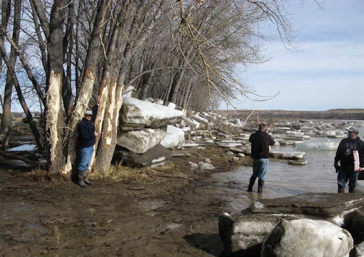
18 IJDB: Tool for Emergency Management Gunnison River, Gunnison, CO Feb 2016 CO DHS requested USACE SPK technical assistance under PL CRREL reviewed IJDB, 9 historic ice jams since 1968 CRREL met with representatives from SPK, local and state officials at Gunnison, CO. Discussed immediate mitigation techniques and opportunities for longer term study.

19

20

21

22

23
24 Gunnison, CO 2016 River ice issues were ongoing CRREL s role was to assess and provide any mitigation support and insights possible. IJDB records are used to more quickly ascertain historical context than previously possible.
25 Historical Record of Ice Jams in Gunnison, CO River Water Year Jam Date Locations Source Gunnison River /8/2016 Taylor River and Gunnison River IJD Ohio Creek /13/2012 near County Rd 48 Bridge IJD Ohio Creek /25/2010 near County Rd 48 Bridge IJD Gunnison River /19/2010 numerous, including tributaries IJD Tomichi Creek /27/2006 near County Rd 38 Bridge IJD Tomichi Creek /26/2004 near County Rd 38 Bridge IJD Ohio Creek /23/2004 near County Rd 48 Bridge IJD Gunnison River /9/ km above Steuben Creek confluence CRREL files Gunnison River /9/ km above Steuben Creek confluence IJD Gunnison River /20/ km above Steuben Creek confluence CRREL files Gunnison River /1/1984 unknown IJD Gunnison River /1/1980 unknown IJD Gunnison River /14/ km above Steuben Creek confluence BoR 1979 Gunnison River /3/ km above Steuben Creek confluence IJD Gunnison River /1/ km above Steuben Creek confluence IJD/BoR 1979 Gunnison River /7/ km above Steuben Creek confluence BoR 1979/CRREL files Gunnison River /10/ km above Steuben Creek confluence BoR 1979/CRREL files Gunnison River /1/1969 flooding at least up to McCabe property IJD Gunnison River /1/1968 flooding near reservoir IJD Tomichi Creek /28/1960 near County Rd 38 Bridge IJD
26 Gunnison, CO 2016 CRREL researched recent and historic hydrologic and meteorologic conditions in the area. This would include records of flow, reservoir levels, air temperature, etc.
27 Gunnison, CO 2016
28 Gunnison, CO 2016


29 Shear Walls
30 Overview of Colorado Ice Jams 324 Colorado ice events documented in the CRREL ice jam database October to May Freezeup and breakup 85 rivers & streams 114 locations in 85 cities/towns/etc

31 Colorado Ice Jams in IJDB
32 Summary of Colorado Jams Colorado experiences both freezeup and breakup ice jams Jams occur most often in December (21%), followed by March (20%). Frequency is close in Jan and Feb. Shear Walls in Gunnison River, Gunnison, CO, 2016

33 CO Ice Jams by Month
34 CO Ice Jams by River

35 CO Ice Jams by City


36 Questions?
U.S. Army Engineer Research and Development Center, Hanover, New Hampshire
 Ice Engineering U.S. Army Engineer Research and Development Center, Hanover, New Hampshire Method to Estimate River Ice Thickness Based on Meteorological Data Some knowledge of ice thickness is required
Missouri River Basin Water Management Monthly Update
 Missouri River Basin Water Management Monthly Update Participating Agencies 255 255 255 237 237 237 0 0 0 217 217 217 163 163 163 200 200 200 131 132 122 239 65 53 80 119 27 National Oceanic and Atmospheric
Corps Involvement in FEMA s Map Modernization Program
 HH&C Tri-Service Infrastructure Conference 2-5 August 2005 - St. Louis Corps Involvement in FEMA s Map Modernization Program Kate White, PhD, PE (CEERD-RN) John Hunter, PE (CELRN) Mark Flick (CELRN) FEMA
IMPLEMENTATION OF AN ICE JAM PREDICTOR WITH USER INTERFACE
 Ice in the Environment: Proceedings of the 16th IAHR International Symposium on Ice Dunedin, New Zealand, 2nd 6th December 2002 International Association of Hydraulic Engineering and Research IMPLEMENTATION
Real-Time Flood Forecasting Modeling in Nashville, TN utilizing HEC-RTS
 Real-Time Flood Forecasting Modeling in Nashville, TN utilizing HEC-RTS Brantley Thames, P.E. Hydraulic Engineer, Water Resources Section Nashville District, USACE August 24, 2017 US Army Corps of Engineers
Missouri River Basin Water Management Monthly Update
 Missouri River Basin Water Management Monthly Update Participating Agencies 255 255 255 237 237 237 0 0 0 217 217 217 163 163 163 200 200 200 131 132 122 239 65 53 80 119 27 National Oceanic and Atmospheric
Missouri River Basin Water Management Monthly Update
 Missouri River Basin Water Management Monthly Update Participating Agencies 255 255 255 237 237 237 0 0 0 217 217 217 163 163 163 200 200 200 131 132 122 239 65 53 80 119 27 National Oceanic and Atmospheric
Development of a Fluvial Erosion Hazard Mitigation Program for Indiana
 Development of a Fluvial Erosion Hazard Mitigation Program for Indiana Indiana Watersheds Webinar Series October 12,2011 Robert Barr Center for Earth and Environmental Science Department of Earth Sciences
NATIONAL HYDROPOWER ASSOCIATION MEETING. December 3, 2008 Birmingham Alabama. Roger McNeil Service Hydrologist NWS Birmingham Alabama
 NATIONAL HYDROPOWER ASSOCIATION MEETING December 3, 2008 Birmingham Alabama Roger McNeil Service Hydrologist NWS Birmingham Alabama There are three commonly described types of Drought: Meteorological drought
President s Day Weekend Storm Community Meeting and Workshop April 17, 2017
 President s Day Weekend Storm Community Meeting and Workshop April 17, 2017 Meeting outline 1. Progress update on the City of San Jose s recovery efforts 2. Water district presentation on: Weather situation
USGS Flood Inundation Mapping of the Suncook River in Chichester, Epsom, Pembroke and Allenstown, New Hampshire
 USGS Flood Inundation Mapping of the Suncook River in Chichester, Epsom, Pembroke and Allenstown, New Hampshire NH Water & Watershed Conference Robert Flynn, USGS NH-VT Water Science Center March 23, 2012
Ice Engineering. Ice Jams, Winter U.S. Army Engineer Research and Development Center, Hanover, New Hampshire
 Ice Engineering U.S. Army Engineer Research and Development Center, Hanover, New Hampshire Ice Jams, Winter 2002 2003 Ice jams are accumulations of ice in rivers, lakes, and streams (Fig. 1) that can cause
YELLOWSTONE RIVER FLOOD STUDY REPORT TEXT
 YELLOWSTONE RIVER FLOOD STUDY REPORT TEXT TECHNICAL REPORT Prepared for: City of Livingston 411 East Callender Livingston, MT 59047 Prepared by: Clear Creek Hydrology, Inc. 1627 West Main Street, #294
Pequabuck River Flooding Study and Flood Mitigation Plan The City of Bristol and Towns of Plainville and Plymouth, CT
 Pequabuck River Flooding Study and Flood Mitigation Plan The City of Bristol and Towns of Plainville and Plymouth, CT Raymond Rogozinski and Maged Aboelata The City of Bristol and Towns of Plainville and
Great Lakes Update. Volume 193: 2015 January through June Summary. Vol. 193 Great Lakes Update August 2015
 Great Lakes Update Volume 193: 2015 January through June Summary The U.S. Army Corps of Engineers (USACE) monitors the water levels of each of the Great Lakes. This report provides a summary of the Great
ESTIMATION OF THE HYDRAULIC ROUGHNESS OF RIVER ICE USING DATA ASSIMILATION
 ESTIMATION OF THE HYDRAULIC ROUGHNESS OF RIVER ICE USING DATA ASSIMILATION Steven F. Daly 1 and Carrie Vuyovich 1 1 ERDC Cold Regions Research and Engineering Laboratory Hanover, NH 03755 ABSTRACT Ice
FEMA Hazards Loss Modeling Task Force (MOTF) Situation Report #14. Colorado Spring Flood Risk ***FINAL REPORT***
 Situation Report #14. Colorado Spring Flood Risk ***FINAL REPORT***") FEMA Hazards Loss Modeling Task Force (MOTF) Situation Report #14 Colorado Spring Flood Risk FEMA Modeling Task Force (MOTF) Denver Federal Center, Building 710A Denver, Colorado 80225 Email: FEMA-MOTF@fema.dhs.gov
FEMA Hazards Loss Modeling Task Force (MOTF) Situation Report #14 Colorado Spring Flood Risk FEMA Modeling Task Force (MOTF) Denver Federal Center, Building 710A Denver, Colorado 80225 Email: FEMA-MOTF@fema.dhs.gov
A New National Flood Inundation Mapping Science Initiative
 A New National Flood Inundation Mapping Science Initiative William Guertal, PhD. Director, USGS Indiana and Kentucky Water Science Centers U.S. Department of the Interior U.S. Geological Survey Courtesy
Missouri River Basin Water Management
 Missouri River Basin Water Management US Army Corps of Engineers Missouri River Navigator s Meeting February 12, 2014 Bill Doan, P.E. Missouri River Basin Water Management US Army Corps of Engineers BUILDING
Out with the Old, In with the New: Implementing the Results of the Iowa Rapid Floodplain Modeling Project
 Out with the Old, In with the New: Implementing the Results of the Iowa Rapid Floodplain Modeling Project Traci Tylski, E.I., CFM Hydraulics Engineer USACE - Omaha District Traci.M.Tylski@USACE.army.mil
Flood Database for Oklahoma: A web-mapping application for spatial data organization and access
 Flood Database for Oklahoma: A web-mapping application for spatial data organization and access Developed in partnership with the Oklahoma Department of Transportation Bridge and Survey Divisions S. Jerrod
NOAA Spring Flood Outlook for Iowa
 NOAA Spring Flood Outlook for Iowa Safeguard Iowa Partnership March 10, 2015 1 Agenda Orientation Maps Current Conditions Weather Outlook Spring Flood Outlook 2 1 Orientation Maps 3 4 2 5 Current Conditions
PUBLIC SAFETY POWER SHUTOFF POLICIES AND PROCEDURES
 PACIFIC GAS AND ELECTRIC COMPANY PUBLIC SAFETY POWER SHUTOFF POLICIES AND PROCEDURES SEPTEMBER 2018 1 PACIFIC GAS AND ELECTRIC COMPANY PUBLIC SAFETY POWER SHUTOFF POLICIES AND PROCEDURES SEPTEMBER 2018
Climate Change and Water Supply Research. Drought Response Workshop October 8, 2013
 Climate Change and Water Supply Research Drought Response Workshop October 8, 2013 DWR Photo Oroville Reservoir, 2009 Talk Overview Expectations History Atmospheric Rivers and Water Supply Current Research
Rainfall-River Forecasting: Overview of NOAA s Role, Responsibilities, and Services
 Dr. Thomas Graziano Chief Hydrologic Services Division NWS Headquarters Steve Buan Service Coordination Hydrologist NWS North Central River Forecast Center Rainfall-River Forecasting: Overview of NOAA
Integrating Weather Forecasts into Folsom Reservoir Operations
 Integrating Weather Forecasts into Folsom Reservoir Operations California Extreme Precipitation Symposium September 6, 2016 Brad Moore, PE US Army Corps of Engineers Biography Brad Moore is a Lead Civil
IDENTIFICATION OF HAZARDS OF CONCERN
 IDENTIFICATION OF HAZARDS OF CONCERN To provide a strong foundation for mitigation strategies considered in Section 6, the Village considered a full range of hazards that could impact the area and then
An overview of the applications for early warning and mapping of the flood events in New Brunswick
 Flood Recovery, Innovation and Reponse IV 239 An overview of the applications for early warning and mapping of the flood events in New Brunswick D. Mioc 1, E. McGillivray 2, F. Anton 1, M. Mezouaghi 2,
United States Multi-Hazard Early Warning System
 United States Multi-Hazard Early Warning System Saving Lives Through Partnership Lynn Maximuk National Weather Service Director, Central Region Kansas City, Missouri America s s Weather Enterprise: Protecting
Doug Kluck NOAA Kansas City, MO National Center for Environmental Information (NCEI) National Integrated Drought Information System (NIDIS)
 National Integrated Drought Information System (NIDIS)") National Integrated Drought Information System (NIDIS) for the Missouri River Basin Drought Early Warning Information System (DEWS) & Runoff Trends in the Missouri Basin & Latest Flood Outlook Doug Kluck
National Integrated Drought Information System (NIDIS) for the Missouri River Basin Drought Early Warning Information System (DEWS) & Runoff Trends in the Missouri Basin & Latest Flood Outlook Doug Kluck
Assessment of the Hood River Delta Hood River, Oregon
 Assessment of the Hood River Delta Hood River, Oregon Pacific Northwest Waterways Association Annual Meeting October 13, 2010 Michael McElwee, Executive Director Port of Hood River Overview U.S. Army Corps
LOMR SUBMITTAL LOWER NEHALEM RIVER TILLAMOOK COUNTY, OREGON
 LOMR SUBMITTAL LOWER NEHALEM RIVER TILLAMOOK COUNTY, OREGON Prepared for: TILLAMOOK COUNTY DEPARTMENT OF COMMUNITY DEVELOPMENT 1510-B THIRD STREET TILLAMOOK, OR 97141 Prepared by: 10300 SW GREENBURG ROAD,
NATIONAL WEATHER SERVICE
 January 2016 February 9, 2016 This was a dry month across the HSA despite one large and several smaller snowfalls. Most locations ended up 1-2 inches below normal for the month. The driest locations at
Drilling Holes in Ice to Reduce Ice Jam Potential
 Drilling Holes in Ice to Reduce Ice Jam Potential Every winter, ice jams on northern rivers cause damages totaling millions of dollars to towns, bridges, levees and other structures. These damages result
Missouri River Basin Water Management Monthly Update
 Missouri River Basin Water Management Monthly Update Participating Agencies 255 255 255 237 237 237 0 0 0 217 217 217 163 163 163 200 200 200 131 132 122 239 65 53 80 119 27 National Oceanic and Atmospheric
OC Public Works El Niño Storm Preparation 2015
 OC Public Works El Niño Storm Preparation 2015 December 8, 2015 Overview About OC Public Works Storm Preparation Pre-Storm During Storm Post-Storm Storm Preparation Canyon and Burn Areas County Department
A Review of the 2007 Water Year in Colorado
 A Review of the 2007 Water Year in Colorado Nolan Doesken Colorado Climate Center, CSU Mike Gillespie Snow Survey Division, USDA, NRCS Presented at the 28 th Annual AGU Hydrology Days, March 26, 2008,
New Hampshire s Flood Hazards Geodatabase
 New Hampshire s Flood Hazards Geodatabase Shane Csiki, PhD, CFM Thomas Taggart, EIT New Hampshire Geological Survey New Hampshire Department of Environmental Services June 20, 2018 Effort to develop statewide
Teresa Santerre Hobby Manager
 Teresa Santerre Hobby Manager Sarita Hedgepeth Assistant Manager Charles Hill GIS Analyst Scott Lindsay Webmaster Work Completed BGS began by collecting historic well data in the Texas Hill Country from
Low Low Water in Puget Sound vs. Mean Sea Level. What do the flood event gauge readings at Sedro Woolley really mean?
 Low Low Water in Puget Sound vs. Mean Sea Level What do the flood event gauge readings at Sedro Woolley really mean? When you make the adjustment of 8.93 feet to the published values and then subtract
Ice Jams, Winter
 US Army Corps of Engineers U.S. Army Cold Regions Research and Engineering Laboratory, Hanover, New Hampshire Ice Jams, Winter 1995 96 An ice jam is an accumulation of ice in a river that restricts water
LOMR SUBMITTAL LOWER NESTUCCA RIVER TILLAMOOK COUNTY, OREGON
 LOMR SUBMITTAL LOWER NESTUCCA RIVER TILLAMOOK COUNTY, OREGON Prepared for: TILLAMOOK COUNTY DEPARTMENT OF COMMUNITY DEVELOPMENT 1510-B THIRD STREET TILLAMOOK, OR 97141 Prepared by: 10300 SW GREENBURG ROAD,
PRECAP. Rivers Breakout Session Final Presentation CAPSTONE 14
 Rivers Breakout Session Final Presentation CAPSTONE 14 Rivers Session Team -Army Corps of Engineers -3 Divisions, 4 Districts -Navigation & Emergency Management -U.S. Coast Guard -U.S. Department of Transportation
Memo. I. Executive Summary. II. ALERT Data Source. III. General System-Wide Reporting Summary. Date: January 26, 2009 To: From: Subject:
 Memo Date: January 26, 2009 To: From: Subject: Kevin Stewart Markus Ritsch 2010 Annual Legacy ALERT Data Analysis Summary Report I. Executive Summary The Urban Drainage and Flood Control District (District)
TRWD Upper Trinity River Flood Operations Decision Support System
 TRWD Upper Trinity River Flood Operations Decision Support System TFMA 2012 Fall Conference Rockwall, Texas September 20, 2012 Presented by: Andrew Ickert, PE, CFM & Craig Ottman, PE, CFM (Halff Associates,
An Overview of Operations at the West Gulf River Forecast Center Gregory Waller Service Coordination Hydrologist NWS - West Gulf River Forecast Center
 National Weather Service West Gulf River Forecast Center An Overview of Operations at the West Gulf River Forecast Center Gregory Waller Service Coordination Hydrologist NWS - West Gulf River Forecast
Storm Surge Analysis Update Meeting Cross City, Florida June 17, 2014
 Big Bend Coastal Storm Surge Study Storm Surge Analysis Update Meeting Cross City, Florida June 17, 2014 Introductions Risk MAP Project Team FEMA Region IV Florida Division of Emergency Management (FDEM)
Needs to Update Probable Maximum Precipitation for Determining Hydrologic Loading on Dams
 Needs to Update Probable Maximum Precipitation for Determining Hydrologic Loading on Dams USSD 2017 Annual Conference Anaheim, CA Chandra S. Pathak, PhD, PE, F.ASCE Engineering and Construction Branch
Modeling of peak inflow dates for a snowmelt dominated basin Evan Heisman. CVEN 6833: Advanced Data Analysis Fall 2012 Prof. Balaji Rajagopalan
 Modeling of peak inflow dates for a snowmelt dominated basin Evan Heisman CVEN 6833: Advanced Data Analysis Fall 2012 Prof. Balaji Rajagopalan The Dworshak reservoir, a project operated by the Army Corps
Daily Operations Briefing Thursday, January 8, :30 a.m. EST
 Daily Operations Briefing Thursday, January 8, 2015 8:30 a.m. EST Significant Activity: Jan 7-8 Significant Events: None Significant Weather: Snow Northern Rockies to Central Plains; Upper Mississippi
Summary of SARP Kickoff Workshop 10/1/ /2/2012
 Summary of SARP Kickoff Workshop 10/1/2012-10/2/2012 On October 1 st a kickoff meeting for the Integrating Climate Forecasts and Reforecasts into Decision Making SARP project was held in Salt Lake City
Applying GIS to Hydraulic Analysis
 Texas A&M University Department of Civil Engineering CVEN689 Applications of GIS to Civil Engineering Instructor: Francisco Olivera, Ph.D., P.E. Applying GIS to Hydraulic Analysis Lim, Chae Kwan April
Great Lakes Tributary Modeling: Canaseraga Creek Watershed
 Great Lakes Tributary Modeling: Canaseraga Creek Watershed SWAT Model Authority: Section 516(e) of WRDA 1996 US Army Corps of Engineers Canaseraga Creek Project Location - Encompasses portions of Livingston,
Flooding in Western North Carolina: Some Spatial, Hydrologic, and Seasonal Characteristics CAUTION!! Outline. Basic Flood Facts.
 Flooding in Western North Carolina: Some Spatial, Hydrologic, and Seasonal Characteristics J. Greg Dobson CAUTION!! National Environmental Modeling and Analysis Center RENCI at UNC-Asheville Engagement
Illinois State Water Survey Division
 Illinois State Water Survey Division SURFACE WATER SECTION SWS Miscellaneous Publication 108 SEDIMENT YIELD AND ACCUMULATION IN THE LOWER CACHE RIVER by Misganaw Demissie Champaign, Illinois June 1989
Operational Perspectives on Hydrologic Model Data Assimilation
 Operational Perspectives on Hydrologic Model Data Assimilation Rob Hartman Hydrologist in Charge NOAA / National Weather Service California-Nevada River Forecast Center Sacramento, CA USA Outline Operational
FORECAST-BASED OPERATIONS AT FOLSOM DAM AND LAKE
 FORECAST-BASED OPERATIONS AT FOLSOM DAM AND LAKE 255 237 237 237 217 217 217 200 200 200 0 163 131 Bridging the Gap163Conference 255 0 132 255 0 163 122 The Dana on Mission Bay San Diego, CA January 28,
REDWOOD VALLEY SUBAREA
 Independent Science Review Panel Conceptual Model of Watershed Hydrology, Surface Water and Groundwater Interactions and Stream Ecology for the Russian River Watershed Appendices A-1 APPENDIX A A-2 REDWOOD
U.S. Army Cold Regions Research and Engineering Laboratory, Hanover, New Hampshire. Ice Events in the Susquehanna River Basin
 Ice Engineering U.S. Army Cold Regions Research and Engineering Laboratory, Hanover, New Hampshire Ice Events in the Susquehanna River Basin As is true for many other rivers in the northern United States,
Folsom Dam Water Control Manual Update Joint Federal Project, Folsom Dam
 Folsom Dam Water Control Manual Update Joint Federal Project, Folsom Dam Public Workshop May 25, 2016 Sacramento Library Galleria 828 I Street, Sacramento, CA US Army Corps of Engineers BUILDING STRONG
NEEDLES S STREET LEVEE SYSTEM SAN BERNARDINO COUNTY, CALIFORNIA NLD SYSTEM ID #
 SAN BERNARDINO COUNTY, CALIFORNIA NLD SYSTEM ID # 3805030008 PERIODIC INSPECTION REPORT NO. 1 GENERALIZED EXECUTIVE SUMMARY FINAL SYSTEM RATING: MINIMALLY ACCEPTABLE FINAL RATING DATE: AUGUST 2014 PERIODIC
South Carolina Seismic Network Bulletin
 South Carolina Seismic Network Bulletin Volume XIII 2003 Prepared by: Pradeep Talwani Abhijit Gangopadhyay and Richard Cannon SPONSORS: Department of Energy/Westinghouse Savannah River Company United States
PRELIMINARY DRAFT FOR DISCUSSION PURPOSES
 Memorandum To: David Thompson From: John Haapala CC: Dan McDonald Bob Montgomery Date: February 24, 2003 File #: 1003551 Re: Lake Wenatchee Historic Water Levels, Operation Model, and Flood Operation This
WYANDOTTE MUNICIPAL SERVICES COMMUNITY WIND ENERGY PROJECT WIND RESOUCE SUMMARY
 WYANDOTTE MUNICIPAL SERVICES COMMUNITY WIND ENERGY PROJECT WIND RESOUCE SUMMARY MONTHLY REPORT October 15, 2007 Black & Veatch Project: 144374 Prepared by: Black & Veatch Corporation 6300 S. Syracuse Way
 Water Supply Forecast - THE DALLES http://www.nwrfc.noaa.gov/water_supply/ws_forecasts.php?id=tdao3 Page 1 of 1 3/7/2013 Close Archive Data/Normals Rankings Adjustments Verification Verify All Years Help
B.2 Sources for Hazard Identification, Profiling, and Ranking (Section 3) Overview of Sussex County s History of Hazards
 Overview of Sussex County s History of Hazards") Appendix B Sources B.1 Sources for Planning Process (Section 2) FEMA. Mitigation Planning Guidance (386 Series). Available on the web at: http://www.fema.gov/plan/mitplanning/planning_resources.shtm FEMA
Appendix B Sources B.1 Sources for Planning Process (Section 2) FEMA. Mitigation Planning Guidance (386 Series). Available on the web at: http://www.fema.gov/plan/mitplanning/planning_resources.shtm FEMA
TMC Monthly Operational Summary
 TMC Monthly Operational Summary July 1 Bureau of Transportation Systems Management & Operations (TSMO) NH Department of Transportation s Mission Transportation excellence enhancing the quality of life
ARMSTRONG COUNTY, PA
 ARMSTRONG COUNTY, PA Revised Preliminary DFIRM Mapping March 31, 2013 Kevin Donnelly, P.E., CFM GG3, Greenhorne & O Mara, Inc. Presentation Agenda Armstrong County DFIRM Overview - June 25, 2010 DFIRM
FY 2002 ANNUAL PROJECT REPORT PROJECT NUMBER: 107. I. Project Title: Gunnison River / Aspinall Unit Temperature Model: Phase II
 COLORADO RIVER RECOVERY PROGRAM RECOVERY PROGRAM FY 2002 ANNUAL PROJECT REPORT PROJECT NUMBER: 107 I. Project Title: Gunnison River / Aspinall Unit Temperature Model: Phase II II. Principal Investigators:
COUNTRY REPORT. Jakarta. July, th National Directorate of Meteorology and Geophysics of Timor-Leste (DNMG)
") The Southeastern Asia-Oceania Flash Flood COUNTRY REPORT Jakarta. July, 10-12 th 2017 National Directorate of Meteorology and Geophysics of Timor-Leste (DNMG) Carla Feritas and Crisostimo Lobato Democratic
The Southeastern Asia-Oceania Flash Flood COUNTRY REPORT Jakarta. July, 10-12 th 2017 National Directorate of Meteorology and Geophysics of Timor-Leste (DNMG) Carla Feritas and Crisostimo Lobato Democratic
HEC & GIS Modeling of the Brushy Creek HEC & GIS Watershed Modeling of the
 HEC & GIS Modeling of the Brushy Creek HEC & GIS Watershed Modeling of the By Cassandra Fagan 5, December 2014 http://ubcwatershedstudy.ursokr.com/images/ Contents Introduction... 3 Figure 1: 24-hour rainfall
Great Lakes Update. Volume 199: 2017 Annual Summary. Background
 Great Lakes Update Volume 199: 2017 Annual Summary Background The U.S. Army Corps of Engineers (USACE) tracks and forecasts the water levels of each of the Great Lakes. This report is primarily focused
Assessing Spatial and Temporal Distribution of Sediment, Nitrogen and Phosphorous Loading in the Missouri River Basin (MORB)
") Assessing Spatial and Temporal Distribution of Sediment, Nitrogen and Phosphorous Loading in the Missouri River Basin (MORB) Zhonglong Zhang, PhD, PE, May Wu, PhD LimnoTech, Environmental Laboratory, ERDC,
Assessing Spatial and Temporal Distribution of Sediment, Nitrogen and Phosphorous Loading in the Missouri River Basin (MORB) Zhonglong Zhang, PhD, PE, May Wu, PhD LimnoTech, Environmental Laboratory, ERDC,
Final Report. COMET Partner's Project. University of Texas at San Antonio
 Final Report COMET Partner's Project University: Name of University Researcher Preparing Report: University of Texas at San Antonio Dr. Hongjie Xie National Weather Service Office: Name of National Weather
Pompton Lakes Dam Downstream Effects of the Floodgate Facility. Joseph Ruggeri Brian Cahill Michael Mak Andy Bonner
 Pompton Lakes Dam Downstream Effects of the Joseph Ruggeri Brian Cahill Michael Mak Andy Bonner ASFPM 2013: Overview Page 2 Overview Page 3 Overview Page 4 Overview Page 5 Overview - Historical Pompton
Wednesday, March 30, 2016
 Total Active DRs 7 Total DRs issued since January 1st 34 Total Number of Shelters Open* 7 (-3) Total Population in Shelters* 143 (-344) Disaster Assessment (Estimated Cumulative) Total: Major + Destroyed:
Folsom Dam Water Control Manual Update Joint Federal Project, Folsom Dam
 Folsom Dam Water Control Manual Update Joint Federal Project, Folsom Dam Public Workshop May 28, 2015 Library Galleria 828 I Street, Sacramento, CA US Army Corps of Engineers BUILDING STRONG WELCOME &
Lower Tuolumne River Accretion (La Grange to Modesto) Estimated daily flows ( ) for the Operations Model Don Pedro Project Relicensing
 Estimated daily flows ( ) for the Operations Model Don Pedro Project Relicensing") Lower Tuolumne River Accretion (La Grange to Modesto) Estimated daily flows (1970-2010) for the Operations Model Don Pedro Project Relicensing 1.0 Objective Using available data, develop a daily time series
Lower Tuolumne River Accretion (La Grange to Modesto) Estimated daily flows (1970-2010) for the Operations Model Don Pedro Project Relicensing 1.0 Objective Using available data, develop a daily time series
Challenges in providing effective flood forecasts and warnings
 Challenges in providing effective flood forecasts and warnings National Centre for Flood Research Inaugural Symposium Justin Robinson Bureau of Meteorology October 2018 Zero Lives Lost A key responsibility
Robert Shedd Northeast River Forecast Center National Weather Service Taunton, Massachusetts, USA
 Robert Shedd Northeast River Forecast Center National Weather Service Taunton, Massachusetts, USA Outline River Forecast Centers FEWS Implementation Status Forcing Data Ensemble Forecasting The Northeast
TMC Monthly Operational Summary
 TMC Monthly Operational Summary March Bureau of Transportation Systems Management & Operations (TSMO) NH Department of Transportation s Mission Transportation excellence enhancing the quality of life in
Tri-Agency Fusion Team Brief Interagency Coordination Meeting Improving Joint Operations. USACE/USGS/NWS Silver Spring, MD. Friday, 11 June 2010
 Tri-Agency Fusion Team Brief Interagency Coordination Meeting Improving Joint Operations USACE/USGS/NWS Silver Spring, MD Friday, 11 June 2010 USACE suggested team as a 2008 Midwest Flood after-action
APPENDIX J MODELING TEHCNICAL MEMORANDUM (RESSIM MODELING)
") APPENDIX J MODELING TEHCNICAL MEMORANDUM (RESSIM MODELING) Technical Memorandum To: Michael J. Preszler, California Water Consulting From: Marieke Armstrong, Mead & Hunt Rahul Ranade, Mead & Hunt Date:
APPENDIX J MODELING TEHCNICAL MEMORANDUM (RESSIM MODELING) Technical Memorandum To: Michael J. Preszler, California Water Consulting From: Marieke Armstrong, Mead & Hunt Rahul Ranade, Mead & Hunt Date:
L OWER N OOKSACK R IVER P ROJECT: A LTERNATIVES A NALYSIS A PPENDIX A: H YDRAULIC M ODELING. PREPARED BY: LandC, etc, LLC
 L OWER N OOKSACK R IVER P ROJECT: A LTERNATIVES A NALYSIS A PPENDIX A: H YDRAULIC M ODELING PREPARED BY: LandC, etc, LLC TABLE OF CONTENTS 1 Introduction... 1 2 Methods... 1 2.1 Hydraulic Model... 1 2.2
Historical Ice Jam Flooding Damages in the United States Course No. SE0186 PDH: 1
 Historical Ice Jam Flooding Damages in the United States Course No. SE0186 PDH: 1 ** PLEASE NOTE: THIS COURSE IS A SUBSECTION OF COURSE # SE0141 ** In order to obtain credit for this course, the following
Highlights of the 2006 Water Year in Colorado
 Highlights of the 2006 Water Year in Colorado Nolan Doesken, State Climatologist Atmospheric Science Department Colorado State University http://ccc.atmos.colostate.edu Presented to 61 st Annual Meeting
Using ArcGIS 10 to Estimate the U.S. Population Affected by Drought
 Using ArcGIS 10 to Estimate the U.S. Population Affected by Drought Jeff Nothwehr National Drought Mitigation Center University of Nebraska-Lincoln Overview What is the U.S. Drought Monitor Mapping Process
Folsom Dam Water Control Manual Update
 Folsom Dam Water Control Manual Update Public Workshop April 3, 2014 Location: Sterling Hotel Ballroom 1300 H Street, Sacramento US Army Corps of Engineers BUILDING STRONG WELCOME & INTRODUCTIONS 2 BUILDING
A Preliminary Severe Winter Storms Climatology for Missouri from
 A Preliminary Severe Winter Storms Climatology for Missouri from 1960-2010 K.L. Crandall and P.S Market University of Missouri Department of Soil, Environmental and Atmospheric Sciences Introduction The
Real-Time Meteorological Gridded Data: What s New With HEC-RAS
 Real-Time Meteorological Gridded Data: What s New With HEC-RAS Acquisition and Application of Gridded Meteorological Data in Support of the USACE s Real-Time Water Management Mission Fauwaz Hanbali, Tom
Applications of a GIS Floodplain Mapping Model valley identification, connectivity indexing, and emergency management.
 Applications of a GIS Floodplain Mapping Model valley identification, connectivity indexing, and emergency management. Jude H. Kastens, Debra S. Baker, Donald G. Huggins, and Kevin E. Dobbs University
The Climate of Payne County
 The Climate of Payne County Payne County is part of the Central Great Plains in the west, encompassing some of the best agricultural land in Oklahoma. Payne County is also part of the Crosstimbers in the
Flood Forecasting Methodology in Alberta
 Flood Forecasting Methodology in Alberta Evan Friesenhan, M.Eng., P.Eng Alberta Environment and Sustainable Resource Development March 17, 2014 River Forecast Team Mandate To provide Albertans with information
USACE-ERDC Coastal Storm Modeling System Updates Chris Massey, PhD
 USACE-ERDC Coastal Storm Modeling System Updates Chris Massey, PhD Research Mathematician USACE-ERDC Coastal & Hydraulics Lab Chris.Massey@usace.army.mil ERDC s Coastal Storm-Modeling System (ERDC CSTORM-MS)
The Kentucky Mesonet: Entering a New Phase
 The Kentucky Mesonet: Entering a New Phase Stuart A. Foster State Climatologist Kentucky Climate Center Western Kentucky University KCJEA Winter Conference Lexington, Kentucky February 9, 2017 Kentucky
Floodplain Mapping & Flood Warning Applications in North Carolina
 Floodplain Mapping & Flood Warning Applications in North Carolina Marc Stanard, IT Project Manager Ken Ashe, Assistant Director David Herlong, Flood Warning Program Manager NC Crime Control & Public Safety
Hydrologic Conditions in the Delaware River Basin
 2017 Hydrologic Conditions in the Delaware River Basin Prepared by Operations Staff June 2018 Hydrologic Highlights Hydrologic Conditions in the Delaware River Basin Annual Report 2017 At the start of
CoCoRaHS Monitoring Colorado s s Water Resources through Community Collaborations
 CoCoRaHS Monitoring Colorado s s Water Resources through Community Collaborations Nolan Doesken Colorado Climate Center Atmospheric Science Department Colorado State University Presented at Sustaining
5.2. IDENTIFICATION OF NATURAL HAZARDS OF CONCERN
 5.2. IDENTIFICATION OF NATURAL HAZARDS OF CONCERN To provide a strong foundation for mitigation strategies considered in Sections 6 and 9, County considered a full range of natural hazards that could impact
Breaking the 5 Mile per Hour Barrier: Automated Mapping Using a Normal Depth Calculation
 Breaking the 5 Mile per Hour Barrier: Automated Mapping Using a Normal Depth Calculation Jeffrey T. Shafer, P.E. and James R. Williams, P.E. Nebraska Department of Natural Resources Introduction In 1998,