TRWD Upper Trinity River Flood Operations Decision Support System
|
|
|
- Andrea Sylvia Nichols
- 6 years ago
- Views:
Transcription
1 TRWD Upper Trinity River Flood Operations Decision Support System TFMA 2012 Fall Conference Rockwall, Texas September 20, 2012 Presented by: Andrew Ickert, PE, CFM & Craig Ottman, PE, CFM (Halff Associates, Inc.) Courtney Jalbert - TRWD
2 Overview Background and Objective of Project Data Inputs Models (HEC Tools) Making a Forecast System Components Lessons Learned

3 Background & Objectives Real-Time Decision Support System utilizing HEC products. Upper Basin More Lead Time for Gate Operations Floodway-Improve Operations Personnel Response
4 Solution Aviso FS and Aviso Watch What does it do? Allows forecasters to interact with HEC software through an easy to use GUI Loss parameter adjustment Reservoir release alternatives Gathers observed data for HEC models Prepares HEC-HMS output for input to HEC- RAS & HEC-ResSim Real-time data viewing Monitors and warns based on observed and forecasted data
5
6 Data Inputs for Models Rainfall Streamflow Reservoir & River Stage Reservoir Release Reservoir Inflow

7 TRWD Model Integration HEC-HMS HEC-RAS HEC-ResSim Lake Worth releases only
8 Models Behind Aviso FS HEC-HMS Compute inflows for Upper Basin HEC-ResSim Model Compute inflows for Floodway/Sump HEC-RAS Model HEC-ResSim Simulates reservoir operations at Lake Bridgeport and Eagle Mountain Lake based on TRWD operational guidelines Allows TRWD to evaluate impacts of alternative reservoir operations HEC-RAS Unsteady flow computations of the Trinity River in the Fort Worth Floodway Model sump stages and gravity sluice discharges to Trinity River
9 Forecasting Timeline Lookback period Forecast period Simulation start Time of forecast (now) End of forecast
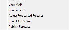
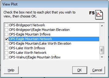
10 Making a Forecast Set forecast window Fetch observed data View observed data Model Calibration/Adjustment View MAP Adjust Loss and Baseflow Parameters Validate results with preconfigured plots Run Forecast Models are re-run with QPF Forecasted reservoir releases can be adjusted Floodway inundation maps are queried Publish Forecast Model input/output archived Results published to a database for monitoring
11 Setting a Forecast Time Window Look Forward Forecast period Look Backward Calibration period Observed data
12 Fetching the Current Data Fetch Gets the data from the Hydromart DB Enter Observed Reservoir Releases Eagle Mtn Lake Lake Bridgeport
13 What s Happening Now?


14 Viewing the Data - HEC-DSSVue
15 Evaluating Observed Rainfall - MAP
16 Forecasting Runoff - (HEC-HMS) Run Calibration Runoff forecast from HEC-HMS without QPF Run Forecast Run Forecast Runoff forecast from HEC-HMS (both with and without QPF)
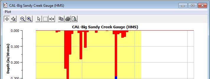
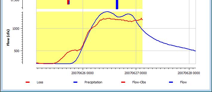
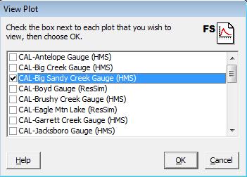
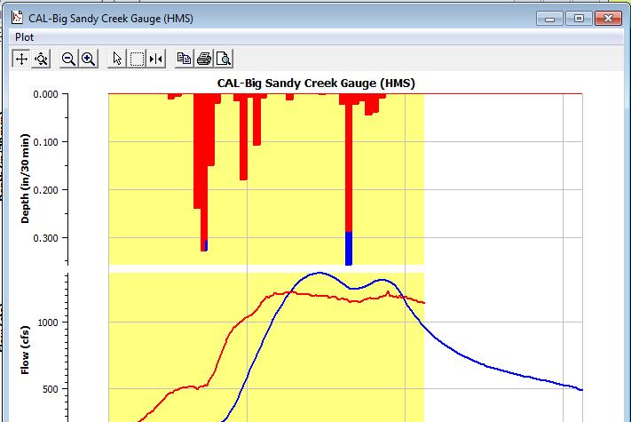
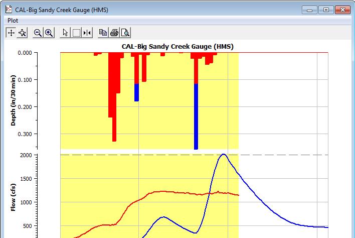
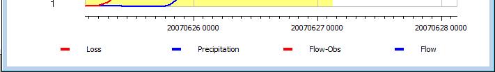
17 Evaluating the Forecast - Plots

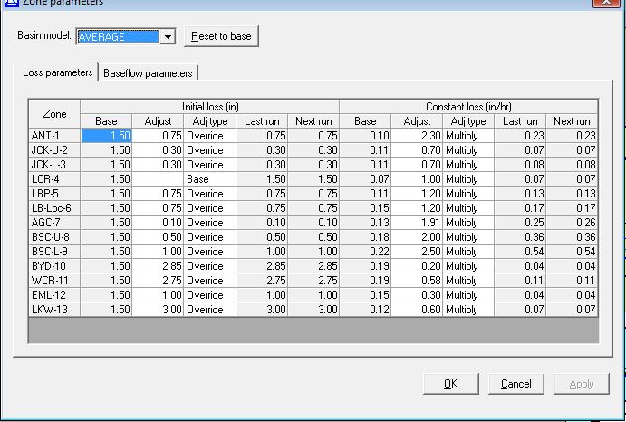
18 Adjusting Model Runoff Parameters


19 Model Adjustment Base Parameters Examples of the 3 different moisture conditions with the same storm Average appears to be a good starting point WET AVG DRY
20 Model Adjustments Calibration
21 Simulating Reservoir Releases - (HEC-ResSim) Run Forecast Runoff forecast from HEC-HMS as input Adjust Forecasted Releases Specify desired releases Re-simulate release
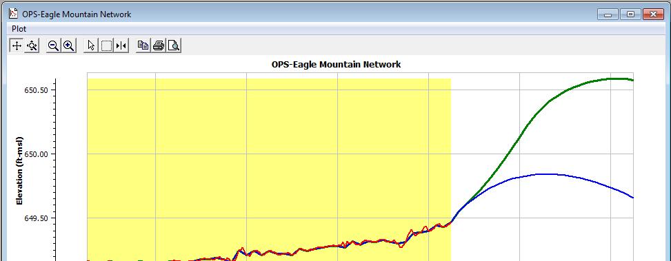
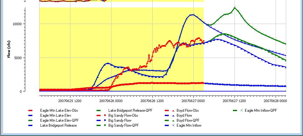
22 Evaluating the Forecast - Reservoir Release Plots


23 Adjusting Forecasted Reservoir Releases Specify release By outlet setting By total release Approach HEC-ResSim will try match releases if possible (Other rules or physical constraints may prohibit desired release)
24 Routing Flows - (HEC-RAS) Floodway only Run Calibration Runoff (HEC-HMS) w/o QPF as input Run Forecast Runoff (HEC-HMS) as input (w/ and w/o QPF)


25 Viewing the Results
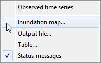
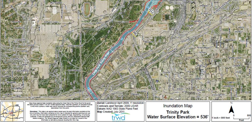
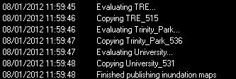
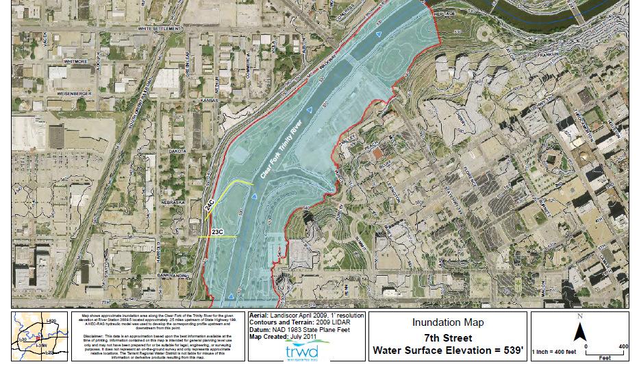
26 Viewing Inundation Maps
27 Publishing the Forecast Observed Data Results Loss and Baseflow Parameters Release Overrides HEC-DSS forecast data cache Compressed files for each forecast


28 Aviso Watch Monitors observed data and forecasted results to provide customized warnings via and text messaging
29
30 Lessons Learned Data, data, data.. Formats Time intervals and time steps Missing?? Run times are critical IT department coordination Forecasting model is different than a planning model Devil is in the details
31 Questions Andrew Ickert Craig Ottman Courtney Jalbert
32
33 System Goals/Objectives 1. Operate in real-time environment 2. Forecast flood flows and elevations along the Fort Worth Floodway 3. Provide decision support for Upper Basin reservoir operations 4. Provide inundation mapping along the Floodway and sumps 5. Provide automated warnings/alerts
34 System Requirements 1. Utilize HEC modeling software 2. Secure 3. Fit within context of existing TRWD system 4. Fit within existing agency arrangements 5. Limit disclosure of sensitive information
35 HEC-HMS Basin Setup Two Models Upper Basin Headwaters to Lake Worth 2,052 sqmi/62 Sub-basins Floodway/Sump Lake Worth and Benbrook Lake to Precinct Line Rd 295 sqmi/41 Floodway Sub-basins & 32 Sump Sub-basins Loss Model Initial and Constant Transform Model Snyder UH Baseflow Model (Upper only) Recession Routing Modified Puls Upper WFTR and Tribs Floodway/Sump Tribs only

36 HEC-HMS Meteorology Setup Precipitation Sources NWS MPE Data stored as a time series for each HRAP cell 3-hr Lag between Real-Time and most recent data value TRWD, USGS, and City of Ft Worth gauges NWS QPF Data stored as a time series for each HRAP cell Forecasted Precipitation 6-Hour blocks Upper Basin NWS MPE and QPF data used MAP computed with Gage Weights method Floodway/Sump All sources utilized MAP computed with IDW method Precipitation data is clipped for a seamless transition from MPE Gauge QPF


37 HEC-ResSim 3 Reservoirs Lake Bridgeport Low Flow Valve Service Spillway Emergency Spillway* Eagle Mountain Lake Low Flow Valves Old Service Spillway* New Side Delivery Spillway Emergency Spillway* Lake Worth Service Spillway * Emergency Spillway* Modified Puls river routing Rules based on TRWD operational guidelines *Uncontrolled spillway

 30 Lateral Structures (Levees) 29 Storage Areas (Sumps) 18 Storage Area Connections (Sump to sump flow) 1 Pump")
38 HEC-RAS Geometry Fort Worth Floodway Based on existing hydraulic model provided by TRWD Halff s Modifications Sumps and Levees added Clear Fork cross-sections georeferenced Extents: Clear Fork Benbrook Lake to West Fork Confluence West Fork Lake Worth to Precinct Line Rd Nearly 30 River miles 617 Cross-sections 45 Bridges 22 Inline Structures (Dams) 30 Lateral Structures (Levees) 29 Storage Areas (Sumps) 18 Storage Area Connections (Sump to sump flow) 1 Pump Station


39 HEC-RAS Sumps and Levees Sumps and Levees A C Sumps Elev.-Vol. Curves D 2009 TNRIS LiDAR City of Fort Worth storm sewer plans Flow between sumps modeled with storage Levees area connections A B 2009 TNRIS LiDAR Weir Equtation 2009 TNRIS LiDAR used for levee profiles C TRWD sump plans and field survey used for sluice dimensions and elevations D Flap gates modeled with a one-way flow restriction B

40 Two-Phase Approach Phase I Scoping/Planning Goals of System Constraints Existing Models, Tools, Databases, etc... Meeting w/ USACE, USGS, NWS WGRFC, City of Fort Worth, TRWD Needs Assessment Plan Formulation Cost-Schedule Phase II Development Testing Deployment Training


41 Run Forecast Adjust Forecasted Releases View Inundation Maps
Merced Irrigation District Hydrologic and Hydraulic Operations (MIDH2O) Model
 Model") Merced Irrigation District Hydrologic and Hydraulic Operations (MIDH2O) Model September 05, 2018 Marco Bell, Merced Irrigation District Bibek Joshi, Dewberry Objective Introduce HEC-RTS Benefits of MIDH2O
Merced Irrigation District Hydrologic and Hydraulic Operations (MIDH2O) Model September 05, 2018 Marco Bell, Merced Irrigation District Bibek Joshi, Dewberry Objective Introduce HEC-RTS Benefits of MIDH2O
INTRODUCTION TO HEC-HMS
 INTRODUCTION TO HEC-HMS Hydrologic Engineering Center- Hydrologic Modeling System US Army Corps of Engineers Hydrologic Engineering Center HEC-HMS Uses Schematics Enter properties: watershed, rivers (reaches),
Pompton Lakes Dam Downstream Effects of the Floodgate Facility. Joseph Ruggeri Brian Cahill Michael Mak Andy Bonner
 Pompton Lakes Dam Downstream Effects of the Joseph Ruggeri Brian Cahill Michael Mak Andy Bonner ASFPM 2013: Overview Page 2 Overview Page 3 Overview Page 4 Overview Page 5 Overview - Historical Pompton
Leveraging new models and data to improve flood stage forecast. Improving Flood Stage Forecasting in the Feather River Watershed. September 11 th 2015
 Leveraging new models and data to improve flood stage forecast Improving Flood Stage Forecasting in the Feather River Watershed September 11 th 2015 Mitch Russo, P.E. (DWR) Ashok Bathulla, P.E., CFM (GEI)
CWMS Modeling for Real-Time Water Management
 Hydrologic Engineering Center Training Course on CWMS Modeling for Real-Time Water Management August 2018 Davis, California The Corps Water Management System (CWMS) is a software and hardware system to
Real-Time Flood Forecasting Modeling in Nashville, TN utilizing HEC-RTS
 Real-Time Flood Forecasting Modeling in Nashville, TN utilizing HEC-RTS Brantley Thames, P.E. Hydraulic Engineer, Water Resources Section Nashville District, USACE August 24, 2017 US Army Corps of Engineers
6/9/2014. Software Overview. System Overview
 Future Rainfall 6/9/2014 Curtis Beitel, PE, CFM, Anthony Henry and Wayne Tschirhart, PE, CFM, PMP TFMA Spring 2014 Conference Software Overview 2 Processes Hydrometric DB Event Manager Automatic Low =
A Cloud-Based Flood Warning System For Forecasting Impacts to Transportation Infrastructure Systems
 A Cloud-Based Flood Warning System For Forecasting Impacts to Transportation Infrastructure Systems Jon Goodall Associate Professor, Civil and Environmental Engineering Associate Director, Link Lab April
INTRODUCTION TO HYDROLOGIC MODELING USING HEC-HMS
 INTRODUCTION TO HYDROLOGIC MODELING USING HEC-HMS By Thomas T. Burke, Jr., PhD, PE Luke J. Sherry, PE, CFM Christopher B. Burke Engineering, Ltd. October 8, 2014 1 SEMINAR OUTLINE Overview of hydrologic
An Overview of Operations at the West Gulf River Forecast Center Gregory Waller Service Coordination Hydrologist NWS - West Gulf River Forecast Center
 National Weather Service West Gulf River Forecast Center An Overview of Operations at the West Gulf River Forecast Center Gregory Waller Service Coordination Hydrologist NWS - West Gulf River Forecast
Workshop: Build a Basic HEC-HMS Model from Scratch
 Workshop: Build a Basic HEC-HMS Model from Scratch This workshop is designed to help new users of HEC-HMS learn how to apply the software. Not all the capabilities in HEC-HMS are demonstrated in the workshop
Rucker Pond. Background
 Rucker Pond Background The Rucker Basin consists of two subbasins (East and West) that drain to a single area known as Rucker Pond. Both subbasins have the same hydraulic parameters, but have different
9. PROBABLE MAXIMUM PRECIPITATION AND PROBABLE MAXIMUM FLOOD
 9. PROBABLE MAXIMUM PRECIPITATION AND PROBABLE MAXIMUM FLOOD 9.1. Introduction Due to the size of Watana Dam and the economic importance of the Project to the Railbelt, the Probable Maximum Flood (PMF)
Hydrologic Modeling System HEC-HMS
 Hydrologic Engineering Center Hydrologic Modeling System HEC-HMS Quick Start Guide Version 3.3 September 2008 Approved for Public Release Distribution Unlimited CPD-74D REPORT DOCUMENTATION PAGE Form Approved
THE TRINITY RIVER VISION/ GATEWAY PARK / PANTHER ISLAND Flood Control Project Update
 Quarterly Project Status Report September 2018 THE TRINITY RIVER VISION/ GATEWAY PARK / PANTHER ISLAND Flood Control Project Update TxDot s contractor has nearly completed the superstructure false work
HYDROLOGIC ENSEMBLE FORECASTING
 HYDROLOGIC ENSEMBLE FORECASTING Dong-Jun Seo 1, Sunghee Kim 1, Hossein Sadeghi 1, Frank Bell 2, Andrew Philpott 2 1 Dept. of Civil Eng., The University of Texas at Arlington, Arlington, TX 2 West Gulf
Advanced /Surface Hydrology Dr. Jagadish Torlapati Fall 2017 MODULE 2 - ROUTING METHODS
 Routing MODULE - ROUTING METHODS Routing is the process of find the distribution of flow rate and depth in space and time along a river or storm sewer. Routing is also called Flow routing or flood routing.
THE TRINITY RIVER VISION/ GATEWAY PARK / PANTHER ISLAND
 Quarterly Project Status Report May 2018 THE TRINITY RIVER VISION/ GATEWAY PARK / PANTHER ISLAND Flood Control Project Update Construction of North Main Street Bridge by TxDOT s bridge contractor, Texas
Flash Flood Guidance System On-going Enhancements
 Flash Flood Guidance System On-going Enhancements Hydrologic Research Center, USA Technical Developer SAOFFG Steering Committee Meeting 1 10-12 July 2017 Jakarta, INDONESIA Theresa M. Modrick Hansen, PhD
Hydrologic Modeling System HEC-HMS
 Hydrologic Engineering Center Hydrologic Modeling System HEC-HMS Quick Start Guide Version 3.5 August 2010 Approved for Public Release Distribution Unlimited CPD-74D REPORT DOCUMENTATION PAGE Form Approved
INFLOW DESIGN FLOOD CONTROL SYSTEM PLAN 40 C.F.R. PART PLANT YATES ASH POND 2 (AP-2) GEORGIA POWER COMPANY
 GEORGIA POWER COMPANY") INFLOW DESIGN FLOOD CONTROL SYSTEM PLAN 40 C.F.R. PART 257.82 PLANT YATES ASH POND 2 (AP-2) GEORGIA POWER COMPANY EPA s Disposal of Coal Combustion Residuals from Electric Utilities Final Rule (40 C.F.R.
INFLOW DESIGN FLOOD CONTROL SYSTEM PLAN 40 C.F.R. PART 257.82 PLANT YATES ASH POND 2 (AP-2) GEORGIA POWER COMPANY EPA s Disposal of Coal Combustion Residuals from Electric Utilities Final Rule (40 C.F.R.
Real-Time Meteorological Gridded Data: What s New With HEC-RAS
 Real-Time Meteorological Gridded Data: What s New With HEC-RAS Acquisition and Application of Gridded Meteorological Data in Support of the USACE s Real-Time Water Management Mission Fauwaz Hanbali, Tom
Arkansas-Red Basin River Forecast Center Operations. RRVA Conference Durant, OK 8/22/2013 Jeff McMurphy Sr. Hydrologist - ABRFC
 Arkansas-Red Basin River Forecast Center Operations RRVA Conference Durant, OK 8/22/2013 Jeff McMurphy Sr. Hydrologist - ABRFC NWS River Forecast Centers NWS Weather Forecast Offices Operations Staffing
Preliminary Viability Assessment (PVA) for Lake Mendocino Forecast Informed Reservoir Operations (FIRO)
 for Lake Mendocino Forecast Informed Reservoir Operations (FIRO)") Preliminary Viability Assessment (PVA) for Lake Mendocino Forecast Informed Reservoir Operations (FIRO) Rob Hartman Consultant to SCWA and CW3E May 30, 2017 Why Conduct a PVA? Key Questions for the PVA
Preliminary Viability Assessment (PVA) for Lake Mendocino Forecast Informed Reservoir Operations (FIRO) Rob Hartman Consultant to SCWA and CW3E May 30, 2017 Why Conduct a PVA? Key Questions for the PVA
Speakers: NWS Buffalo Dan Kelly and Sarah Jamison, NERFC Jeane Wallace. NWS Flood Services for the Black River Basin
 Speakers: NWS Buffalo Dan Kelly and Sarah Jamison, NERFC Jeane Wallace NWS Flood Services for the Black River Basin National Weather Service Who We Are The National Oceanic and Atmospheric Administration
National Weather Service. Harold H. Opitz Hydrologist in Charge
 National Weather Service Harold H. Opitz Hydrologist in Charge Goals Organization Role of the River Forecast Center Describe Forecast System & Tools Other Details NWS River Forecast Centers Northwest River
Delaware River Basin Flood Analysis Model Independent External Peer Review Report
 Delaware River Basin Flood Analysis Model Independent External Peer Review Report Map source: DRBC Prepared for: Federal Emergency Management Agency, Region III Delaware River Basin Commission Prepared
San Antonio River Authority. San Antonio River Authority Floodworks implementation in the San Antonio River Basin. Nefi Garza, PE, CFM
 San Antonio River Authority Floodworks implementation in the San Antonio River Basin Nefi Garza, PE, CFM San Antonio River Authority Michael Crenshaw, PE, CFM Anthony J. Henry Wallingford Software, Inc
Section 4: Model Development and Application
 Section 4: Model Development and Application The hydrologic model for the Wissahickon Act 167 study was built using GIS layers of land use, hydrologic soil groups, terrain and orthophotography. Within
Rainfall-River Forecasting: Overview of NOAA s Role, Responsibilities, and Services
 Dr. Thomas Graziano Chief Hydrologic Services Division NWS Headquarters Steve Buan Service Coordination Hydrologist NWS North Central River Forecast Center Rainfall-River Forecasting: Overview of NOAA
Model Calibration and Forecast Error for NFIE-Hydro
 Corey Van Dyk C E 397 Flood Forecasting 5/8/15 Model Calibration and Forecast Error for NFIE-Hydro Introduction The forecasting component of the National Flood Interoperability Experiment (NFIE), like
Lessons Learned and Shared
 Lessons Learned and Shared Plan for the worst. Hope for the best. Remember that hope is not a strategy. Agnes 8 Lessons 1. Identify Susceptible Communities 2. Develop a Plan 3. Threat Recognition 4. Review
Riverine Modeling Proof of Concept
 Technical Team Meeting Riverine Modeling Proof of Concept Version 2 HEC-RAS Open-water Flow Routing Model April 15-17, 2014 Prepared by R2 Resource Consultants, Brailey Hydrologic, Geovera, Tetra Tech,
USING GIS TO MODEL AND ANALYZE HISTORICAL FLOODING OF THE GUADALUPE RIVER NEAR NEW BRAUNFELS, TEXAS
 USING GIS TO MODEL AND ANALYZE HISTORICAL FLOODING OF THE GUADALUPE RIVER NEAR NEW BRAUNFELS, TEXAS ASHLEY EVANS While the state of Texas is well-known for flooding, the Guadalupe River Basin is one of
Folsom Dam Water Control Manual Update Joint Federal Project, Folsom Dam
 Folsom Dam Water Control Manual Update Joint Federal Project, Folsom Dam Public Workshop May 25, 2016 Sacramento Library Galleria 828 I Street, Sacramento, CA US Army Corps of Engineers BUILDING STRONG
Folsom Dam Water Control Manual Update
 Folsom Dam Water Control Manual Update Public Workshop April 3, 2014 Location: Sterling Hotel Ballroom 1300 H Street, Sacramento US Army Corps of Engineers BUILDING STRONG WELCOME & INTRODUCTIONS 2 BUILDING
ARMSTRONG COUNTY, PA
 ARMSTRONG COUNTY, PA Revised Preliminary DFIRM Mapping March 31, 2013 Kevin Donnelly, P.E., CFM GG3, Greenhorne & O Mara, Inc. Presentation Agenda Armstrong County DFIRM Overview - June 25, 2010 DFIRM
Study 16.5 Probable Maximum Flood (PMF)
") Initial Study Report Meeting Study 16.5 Probable Maximum Flood (PMF) March 30, 2016 Prepared by 3/30/2016 1 Study 16.5 Status ISR documents (ISR Part D Overview): Status: Initial Study Report: Parts A,
Initial Study Report Meeting Study 16.5 Probable Maximum Flood (PMF) March 30, 2016 Prepared by 3/30/2016 1 Study 16.5 Status ISR documents (ISR Part D Overview): Status: Initial Study Report: Parts A,
ARTICLE 5 (PART 2) DETENTION VOLUME EXAMPLE PROBLEMS
 DETENTION VOLUME EXAMPLE PROBLEMS") ARTICLE 5 (PART 2) DETENTION VOLUME EXAMPLE PROBLEMS Example 5.7 Simple (Detention Nomograph) Example 5.8 Offsite and Unrestricted Areas (HEC-HMS) Example 5.9 Ponds in Series w/ Tailwater (HEC-HMS) Example
ARTICLE 5 (PART 2) DETENTION VOLUME EXAMPLE PROBLEMS Example 5.7 Simple (Detention Nomograph) Example 5.8 Offsite and Unrestricted Areas (HEC-HMS) Example 5.9 Ponds in Series w/ Tailwater (HEC-HMS) Example
D. MATHEMATICAL MODEL AND SIMULATION
 D. MATHEMATICAL MODEL AND SIMULATION D - i TABLE OF CONTENTS D.1 Objective of Model Development... D - 1 D.2 Selection of Software... D - 1 D.3 General Steps of Simulation by MOUSE... D - 1 D.4 Cases of
Pequabuck River Flooding Study and Flood Mitigation Plan The City of Bristol and Towns of Plainville and Plymouth, CT
 Pequabuck River Flooding Study and Flood Mitigation Plan The City of Bristol and Towns of Plainville and Plymouth, CT Raymond Rogozinski and Maged Aboelata The City of Bristol and Towns of Plainville and
UPPER COSUMNES RIVER FLOOD MAPPING
 UPPER COSUMNES RIVER FLOOD MAPPING DRAFT BASIC DATA NARRATIVE FLOOD INSURANCE STUDY SACRAMENTO COUTY, CALIFORNIA Community No. 060262 November 2008 Prepared By: CIVIL ENGINEERING SOLUTIONS, INC. 1325 Howe
Evaluation and Incorporation of USACE HEC-RAS Model of Chicago Waterway System into the Development of the North Branch DWP
 M E M O R A N D U M Evaluation and Incorporation of USACE HEC-RAS Model of Chicago Waterway System into the Development of the North Branch DWP TO: FROM: Joseph Spradling, PE, HDR Steven Vassos, PE, FluidClarity
Souris River Basin Spring Runoff Outlook As of March 15, 2018
 Souris River Basin Spring Runoff Outlook As of March 15, 2018 Prepared by: Flow Forecasting & Operations Planning Water Security Agency Basin Conditions Summer rainfall in 2017 in the Saskatchewan portion
Study 16.5 Probable Maximum Flood (PMF)
") Initial Study Report Meeting Study 16.5 Probable Maximum Flood (PMF) October 22, 2014 Prepared by 10/22/2014 1 Study 16.5 Objectives Develop a site-specific PMP to be used for the derivation of the PMF
Initial Study Report Meeting Study 16.5 Probable Maximum Flood (PMF) October 22, 2014 Prepared by 10/22/2014 1 Study 16.5 Objectives Develop a site-specific PMP to be used for the derivation of the PMF
George Mason University Department of Civil, Environmental and Infrastructure Engineering
 George Mason University Department of Civil, Environmental and Infrastructure Engineering Dr. Celso Ferreira Prepared by Lora Baumgartner December 2015 Revised by Brian Ross July 2016 Exercise Topic: Getting
HEC-RAS Reservoir Transport Simulation of Three Reservoirs in the Lower Susquehanna River Basin. Mike Langland and Ed Koerkle
 HEC-RAS Reservoir Transport Simulation of Three Reservoirs in the Lower Susquehanna River Basin Mike Langland and Ed Koerkle Topics Background / Project Objectives Data Selection - Sediment and Geometric
Results of the Sava River Model
 Results of the Sava River Model Jamie G. James, P.E. Nashville District September 2010 US Army Corps of Engineers BUILDING STRONG Discussion Outline Study Goals Model Limitations HEC-RAS Model Results
LOMR SUBMITTAL LOWER NEHALEM RIVER TILLAMOOK COUNTY, OREGON
 LOMR SUBMITTAL LOWER NEHALEM RIVER TILLAMOOK COUNTY, OREGON Prepared for: TILLAMOOK COUNTY DEPARTMENT OF COMMUNITY DEVELOPMENT 1510-B THIRD STREET TILLAMOOK, OR 97141 Prepared by: 10300 SW GREENBURG ROAD,
Hydrologic Modeling System HEC-HMS
 Hydrologic Engineering Center Hydrologic Modeling System HEC-HMS Quick Start Guide Version 4.1 July 2015 Approved for Public Release Distribution Unlimited CPD-74D REPORT DOCUMENTATION PAGE Form Approved
The Hydrologic Cycle: How Do River Forecast Centers Measure the Parts?
 The Hydrologic Cycle: How Do River Forecast Centers Measure the Parts? Greg Story Meteorologist National Weather Service Fort Worth, TX Overview n Introduction What is the mission of an RFC? n The Hydrologic
GREENE COUNTY, PA. Revised Preliminary DFIRM Mapping FEMA. Kevin Donnelly, P.E., CFM GG3, Greenhorne & O Mara, Inc. April 10, 2013
 GREENE COUNTY, PA Revised Preliminary DFIRM Mapping April 10, 2013 Kevin Donnelly, P.E., CFM GG3, Greenhorne & O Mara, Inc. Presentation Agenda Greene County DFIRM Overview September 30, 2010 DFIRM Countywide
FORECAST-BASED OPERATIONS AT FOLSOM DAM AND LAKE
 FORECAST-BASED OPERATIONS AT FOLSOM DAM AND LAKE 255 237 237 237 217 217 217 200 200 200 0 163 131 Bridging the Gap163Conference 255 0 132 255 0 163 122 The Dana on Mission Bay San Diego, CA January 28,
CONVERTING A NEXRAD MAP TO A FLOODPLAIN MAP. Oscar Robayo, Tim Whiteaker, and David Maidment*
 CONVERTING A NEXRAD MAP TO A FLOODPLAIN MAP Oscar Robayo, Tim Whiteaker, and David Maidment* ABSTRACT: Using ArcGIS 9.0 ArcObjects and the new ModelBuilder environment, a methodology for converting a NEXRAD
Operational Hydrologic Ensemble Forecasting. Rob Hartman Hydrologist in Charge NWS / California-Nevada River Forecast Center
 Operational Hydrologic Ensemble Forecasting Rob Hartman Hydrologist in Charge NWS / California-Nevada River Forecast Center Mission of NWS Hydrologic Services Program Provide river and flood forecasts
EVALUATION OF THE NWS DISTRIBUTED HYDROLOGIC MODEL OVER THE TRINITY RIVER BASIN IN TEXAS
 1 EVALUATION OF THE NWS DISTRIBUTED HYDROLOGIC MODEL OVER THE TRINITY RIVER BASIN IN TEXAS Arezoo Rafieei Nasab 1, Dong-Jun Seo 1, Robert Corby 2 and Paul McKee 2 1- Department of Civil Engineering, The
ResSIMLite vs. ResSIM Model Comparison
 ResSIMLite vs. ResSIM Model Comparison 06/05/2013 M. Cox, OSU The outflow calculations represented in the Envision model have been closely modeled after the representation in the USACE HEC ResSIM model
9. Flood Routing. chapter Two
 9. Flood Routing Flow routing is a mathematical procedure for predicting the changing magnitude, speed, and shape of a flood wave as a function of time at one or more points along a watercourse (waterway
Climate Adaptation Challenges for Boston s Water and Sewer Systems
 National Association of Flood & Stormwater Management Agencies Climate Adaptation Challenges for Boston s Water and Sewer Systems John P Sullivan P.E. October 15,2014 Boston 1630 Boston 1630-2012 Boston
The Beleaguered Figure 15
 The Beleaguered Figure 15 TFMA 2015 Fall Technical Summit After the Floods: Texas Rising Craig Loftin, PE, CFM US Weather Bureau Technical Paper No. 40, Figure 15 Village Creek Watershed 1 100-Year 30-Minute
The Beleaguered Figure 15 TFMA 2015 Fall Technical Summit After the Floods: Texas Rising
 The Beleaguered Figure 15 TFMA 2015 Fall Technical Summit After the Floods: Texas Rising Craig Loftin, PE, CFM US Weather Bureau Technical Paper No. 40, Figure 15 Village Creek Watershed 100-Year 30-Minute
United States Multi-Hazard Early Warning System
 United States Multi-Hazard Early Warning System Saving Lives Through Partnership Lynn Maximuk National Weather Service Director, Central Region Kansas City, Missouri America s s Weather Enterprise: Protecting
Issue 44: Phase II & III H&H Issues Date: 07/03/2006 Page 1
 Background Phase I of the NCFMP studies have primarily focused on the coastal plain and sandhills physiographic regions in of the State. Phase II and III study areas will focus on the piedmont, foothills,
Attachment B to Technical Memorandum No.2. Operations Plan of Ross Valley Detention Basins
 Attachment B to Technical Memorandum No.2 Operations Plan of Ross Valley Detention Basins Operations Plan of Ross Valley Detention Basins Stetson Engineers Inc. January 26, 2011 1.0 Introduction Achieving
Near Real-Time Runoff Estimation Using Spatially Distributed Radar Rainfall Data. Jennifer Hadley 22 April 2003
 Near Real-Time Runoff Estimation Using Spatially Distributed Radar Rainfall Data Jennifer Hadley 22 April 2003 Introduction Water availability has become a major issue in Texas in the last several years,
Operational Perspectives on Hydrologic Model Data Assimilation
 Operational Perspectives on Hydrologic Model Data Assimilation Rob Hartman Hydrologist in Charge NOAA / National Weather Service California-Nevada River Forecast Center Sacramento, CA USA Outline Operational
MEMORANDUM. Situation. David Ford Consulting Engineers, Inc J Street, Suite 200 Sacramento, CA Ph Fx
 David Ford Consulting Engineers, Inc. 2015 J Street, Suite 200 Sacramento, CA 95811 Ph. 916.447.8779 Fx. 916.447.8780 MEMORANDUM To: Brad Moore, PE, USACE From: Nathan Pingel, PE (Lic # CA 63242), and
USGS Flood Inundation Mapping of the Suncook River in Chichester, Epsom, Pembroke and Allenstown, New Hampshire
 USGS Flood Inundation Mapping of the Suncook River in Chichester, Epsom, Pembroke and Allenstown, New Hampshire NH Water & Watershed Conference Robert Flynn, USGS NH-VT Water Science Center March 23, 2012
Souris River Basin Spring Runoff Outlook As of March 1, 2019
 Souris River Basin Spring Runoff Outlook As of March 1, 2019 Prepared by: Flow Forecasting & Operations Planning Water Security Agency Basin Conditions Summer rainfall in 2018 over the Saskatchewan portion
PRELIMINARY DRAFT FOR DISCUSSION PURPOSES
 Memorandum To: David Thompson From: John Haapala CC: Dan McDonald Bob Montgomery Date: February 24, 2003 File #: 1003551 Re: Lake Wenatchee Historic Water Levels, Operation Model, and Flood Operation This
LESSON HEC-HMS
 LESSON 2.2 - HEC-HMS Introduction: TEAM 8 SCS method: The input data: Thiessen Polygons: Concentration Lag Time: SCS Method: Calculation of CN: Result figures: CONSTRUCTING HYDROGRAPH WITH HEC-HMS: Rainfall
Hydrologic Engineering Applications of Geographic Information Systems
 Hydrologic Engineering Applications of Geographic Information Systems Davis, California Objectives: The participant will acquire practical knowledge and skills in the application of GIS technologies for
NRC Workshop Probabilistic Flood Hazard Assessment (PFHA) Jan 29-31, Mel Schaefer Ph.D. P.E. MGS Engineering Consultants, Inc.
 Jan 29-31, Mel Schaefer Ph.D. P.E. MGS Engineering Consultants, Inc.") Stochastic Event Flood Model (SEFM) Stochastic Modeling of Extreme Floods A Hydrological Tool for Analysis of Extreme Floods Mel Schaefer Ph.D. P.E. MGS Engineering Consultants, Inc. Olympia, WA NRC Workshop
Stochastic Event Flood Model (SEFM) Stochastic Modeling of Extreme Floods A Hydrological Tool for Analysis of Extreme Floods Mel Schaefer Ph.D. P.E. MGS Engineering Consultants, Inc. Olympia, WA NRC Workshop
How to integrate wetland processes in river basin modeling? A West African case study
 How to integrate wetland processes in river basin modeling? A West African case study stefan.liersch@pik-potsdam.de fred.hattermann@pik-potsdam.de June 2011 Outline Why is an inundation module required?
HEC-HMS Lab 4 Using Frequency Storms in HEC-HMS
 HEC-HMS Lab 4 Using Frequency Storms in HEC-HMS Created by Venkatesh Merwade (vmerwade@purdue.edu) Learning outcomes The objective of this lab is to learn how HEC-HMS is used to determine design flow by
Integrating Weather Forecasts into Folsom Reservoir Operations
 Integrating Weather Forecasts into Folsom Reservoir Operations California Extreme Precipitation Symposium September 6, 2016 Brad Moore, PE US Army Corps of Engineers Biography Brad Moore is a Lead Civil
MODELING STUDIES WITH HEC-HMS AND RUNOFF SCENARIOS IN YUVACIK BASIN, TURKIYE
 MODELING STUDIES WITH HEC-HMS AND RUNOFF SCENARIOS IN YUVACIK BASIN, TURKIYE Yener, M.K. Şorman, A.Ü. Department of Civil Engineering, Middle East Technical University, 06531 Ankara/Türkiye Şorman, A.A.
NWS SERFC Hydrologic Vulnerability Assessment. Monday, March 9 th, 2015 NOAA, National Weather Service Southeast River Forecast Center
 NWS SERFC Hydrologic Vulnerability Assessment Monday, March 9 th, 2015 NOAA, National Weather Service Southeast River Forecast Center Current Weather Map Today s weather map shows a blossoming system in
JOURNAL OF ENVIRONMENTAL HYDROLOGY The Electronic Journal of the International Association for Environmental Hydrology VOLUME
 JOURNAL OF ENVIRONMENTAL HYDROLOGY The Electronic Journal of the International Association for Environmental Hydrology VOLUME 18 2010 REDUCED CHANNEL CONVEYANCE ON THE WICHITA RIVER AT WICHITA FALLS, TEXAS,
Emergency Action Plan (EAP) Tata Pond Dam
 Tata Pond Dam") For Official Use Only Not for Public Distribution 02/03/16 Emergency Action Plan (EAP) Tata Pond Dam State of Connecticut Dam ID: 0000 Town or City, County, Connecticut Name of Dam Owner Dam Hazard Classification
For Official Use Only Not for Public Distribution 02/03/16 Emergency Action Plan (EAP) Tata Pond Dam State of Connecticut Dam ID: 0000 Town or City, County, Connecticut Name of Dam Owner Dam Hazard Classification
Flood Hazard Inundation Mapping. Presentation. Flood Hazard Mapping
 Flood Hazard Inundation Mapping Verne Schneider, James Verdin, and JeradBales U.S. Geological Survey Reston, VA Presentation Flood Hazard Mapping Requirements Practice in the United States Real Time Inundation
Hydrologic Evaluation of the Blanchard River
 Hydrologic Evaluation of the Blanchard River Hancock County Flood Risk Reduction Program Prepared for: Maumee Watershed Conservancy District 1464 Pinehurst Dr. Defiance, Ohio 43512 Prepared by: Stantec
Operational water balance model for Siilinjärvi mine
 Operational water balance model for Siilinjärvi mine Vesa Kolhinen, Tiia Vento, Juho Jakkila, Markus Huttunen, Marie Korppoo, Bertel Vehviläinen Finnish Environment Institute (SYKE) Freshwater Centre/Watershed
Final Report. COMET Partner's Project. University of Texas at San Antonio
 Final Report COMET Partner's Project University: Name of University Researcher Preparing Report: University of Texas at San Antonio Dr. Hongjie Xie National Weather Service Office: Name of National Weather
Dr. Amanda Schroeder. NWS Weather Forecast Office Fort Worth, TX. Sustainable Urban Water Workshop University of Texas-Arlington June 4-5, 2015
 Dr. Amanda Schroeder NWS Weather Forecast Office Fort Worth, TX Sustainable Urban Water Workshop University of Texas-Arlington June 4-5, 2015 Outline Communicating the message - official Flood and Flash
Predictive Model of Rainfall-Runoff: A Case Study of the Sanaga Basin at Bamendjin Watershed in Cameroon
 Predictive Model of Rainfall-Runoff: A Case Study of the Sanaga Basin at Bamendjin Watershed in Cameroon Terence Kibula Lukong (Corresponding author) Hydrology Division, AES SONEL Douala, P.O. Box 433,
FFGS Additional Functionalities and Products. Konstantine P. Georgakakos, Sc.D. HYDROLOGIC RESEARCH CENTER 23 May 2018
 FFGS Additional Functionalities and Products Konstantine P. Georgakakos, Sc.D. HYDROLOGIC RESEARCH CENTER 23 May 2018 Advanced Functionalities 0. Multi-Model QPF A. Urban Flash Flood Warning B. Riverine
Zone A Modeling (What Makes A Equal Approximate, Adequate, or Awesome)
") Zone A Modeling (What Makes A Equal Approximate, Adequate, or Awesome) ASFPM 2016 GRAND RAPIDS CONFERENCE Kevin Donnelly, P.E., GISP, PMP, CFM June 23, 2016 Agenda 1 Introduction 2 Flood Hazard Analysis
Zone A Modeling (What Makes A Equal Approximate, Adequate, or Awesome) ASFPM 2016 GRAND RAPIDS CONFERENCE Kevin Donnelly, P.E., GISP, PMP, CFM June 23, 2016 Agenda 1 Introduction 2 Flood Hazard Analysis
National Weather Service Flood Forecast Needs: Improved Rainfall Estimates
 National Weather Service Flood Forecast Needs: Improved Rainfall Estimates Weather Forecast Offices Cleveland and Northern Indiana Ohio River Forecast Center Presenter: Sarah Jamison, Service Hydrologist
RESERVOIR RELEASE FORECAST MODEL FOR FLOOD OPERATION OF THE FOLSOM PROJECT INCLUDING PRE-RELEASES ABSTRACT
 RESERVOIR RELEASE FORECAST MODEL FOR FLOOD OPERATION OF THE FOLSOM PROJECT INCLUDING PRE-RELEASES David S. Bowles 1, J. Dean Mathias 2, Sanjay S. Chauhan 3 and Joseph D. Countryman 4 ABSTRACT This paper
Optimal Artificial Neural Network Modeling of Sedimentation yield and Runoff in high flow season of Indus River at Besham Qila for Terbela Dam
 Optimal Artificial Neural Network Modeling of Sedimentation yield and Runoff in high flow season of Indus River at Besham Qila for Terbela Dam Akif Rahim 1, Amina Akif 2 1 Ph.D Scholar in Center of integrated
GIS Techniques for Floodplain Delineation. Dean Djokic
 GIS Techniques for Floodplain Delineation Dean Djokic (ddjokic@esri.com) Content What is a floodplain? How to get a floodplain? What can GIS do for floodplain modeling? Simple GIS techniques for floodplain
Floodplain Mapping & Flood Warning Applications in North Carolina
 Floodplain Mapping & Flood Warning Applications in North Carolina Marc Stanard, IT Project Manager Ken Ashe, Assistant Director David Herlong, Flood Warning Program Manager NC Crime Control & Public Safety
Homework 10. Logan Dry Canyon Detention Basin Design Case Study Date: 4/14/14 Due: 4/25/14
 Homework 10. Logan Dry Canyon Detention Basin Design Case Study Date: 4/14/14 Due: 4/25/14 Section 1: Case Study Introduction This case study serves as an integrative problem based learning exercise. In
Forecast Methods, Products, and Services for the San Joaquin River Basin. Mission of NWS Hydrologic Services Program
 NOAA s s National Weather Service California-Nevada River Forecast Center Forecast Methods, Products, and Services for the San Joaquin River Basin Rob Hartman Hydrologist in Charge Mission of NWS Hydrologic
Error Propagation from Radar Rainfall Nowcasting Fields to a Fully-Distributed Flood Forecasting Model
 Error Propagation from Radar Rainfall Nowcasting Fields to a Fully-Distributed Flood Forecasting Model Enrique R. Vivoni 1, Dara Entekhabi 2 and Ross N. Hoffman 3 1. Department of Earth and Environmental
Memorandum. Background
 Memorandum To: Kevin Stewart, P.E., Information Systems & Flood Warning Program Manager From: Mark Mitisek, H.I.T. Reviewed by: Kelly Close, P.E. Date: 02/11/2013 Project: Boulder Creek Hydromodel Subject:
Modeling of peak inflow dates for a snowmelt dominated basin Evan Heisman. CVEN 6833: Advanced Data Analysis Fall 2012 Prof. Balaji Rajagopalan
 Modeling of peak inflow dates for a snowmelt dominated basin Evan Heisman CVEN 6833: Advanced Data Analysis Fall 2012 Prof. Balaji Rajagopalan The Dworshak reservoir, a project operated by the Army Corps
Bushkill Creek 3 rd Street Dam Removal Analysis
 Bushkill Creek 3 rd Street Dam Removal Analysis HEC HMS Runoff and Routing Model Stephen Beavan, Melanie DeFazio, David Gold, Peter Mara and Dan Moran CE 421: Hydrology Fall 2010 December 15, 2010 Contents
Automated Hydrologic and Hydraulic Modeling of a Hydroelectric System UC1131 July 2012
 Automated Hydrologic and Hydraulic Modeling of a Hydroelectric System UC1131 July 2012 Author: Eok Ngo, Integrated Spatial Solutions, Inc. Contact: engo@issi-gis.com ABSTRACT Balancing the needs of regulatory