Lessons Learned and Shared
|
|
|
- Molly Shepherd
- 5 years ago
- Views:
Transcription

1 Lessons Learned and Shared Plan for the worst. Hope for the best. Remember that hope is not a strategy.

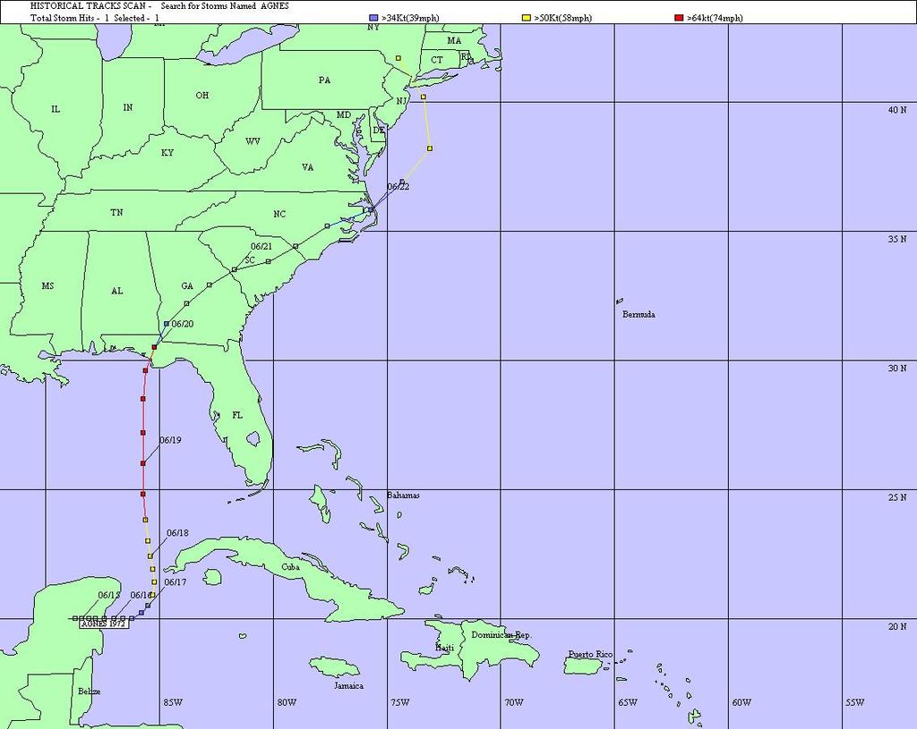
2 Agnes
3 8 Lessons 1. Identify Susceptible Communities 2. Develop a Plan 3. Threat Recognition 4. Review Response Times 5. Training: Practice the Plan 6. Responding: Organization, Communication 7. Recovery 8. Debriefing and Revising the plan
4 Lesson 1 Identify Susceptible Communities


5 Identify Communities 2003 Flooding in New Alexandria; subject to tidal flooding June 2006, Huntington Flooding; subject to flooding from short intense storms and a combination of tide/rain

6 Identify Communities Susceptible to both tidal and riverine flooding Tidal flooding dominates e.g. Hurricane Isabel September 2003, 9.6 ft. tidal surge and 0.5 inches rain Noblis
7 Identify Communities Susceptible to both tidal and riverine flooding Riverine flooding dominates Lake located upstream e.g. Storm of June 2006, 4.0 ft. tide and 8.3 inches rain
8 Lesson 2 Develop a Plan

9 Basic Elements of a Plan
10 Basic Elements of a Plan Goals Prevent loss of life Minimize property damage Reduce disruptions to commerce human activities Meet regulatory requirements

11 Basic Elements of a plan Goals continued Reaching these goals requires: Threat identification Minimizing response times Goals achieved through Effective planning Effective communication Community involvement Education
12 Lesson 3 Threat Recognition Develop predictive tools


13 Prediction Tools Analysis Rainfall run-off hydrologic modeling SCS Tidal hydrology and review of historical tidal records HEC-RAS Hydraulic analysis and water surface profile determination

14 Prediction Tools Development continued Determine the topographic elevation at which the community starts to flood Use hydraulic simulations to determine WSEs with various tidal and discharge combinations Use hydraulic model to determine flood wave travel times and appropriate response times Develop mathematical tools that identify the combinations of tide and discharges that cause flooding above a targeted level Develop triggers (tides and rainfall) that cause flooding above the targeted level
 Qhunt (based on USGS Cameron Run gauge) WSE 4 6899 0 8210 7.0 NOTES 1) Maximum Q=35,000; Maximum tide = 16' 2) P is rainfall in inches.")
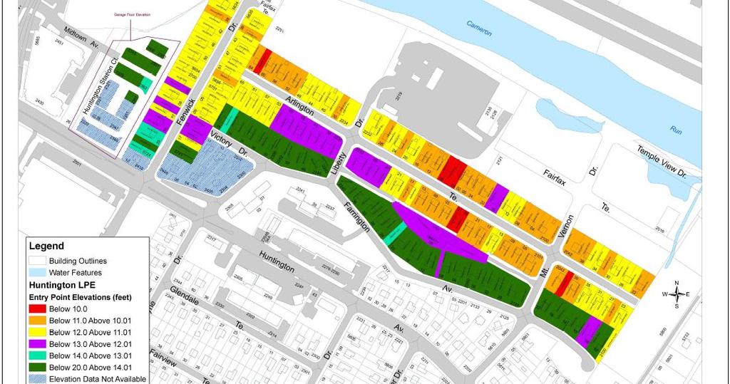
15 Prediction Tools Flow Prediction Tool FENWICK SEC 1389 ROAD Actual Tide P Qgauge (USGS Cameron Run) Q barcroft Q Model Tidal Value Qgauge reg. for USGS Cameron Run Qhunt (Barcroft) Qhunt (based on USGS Cameron Run gauge) WSE NOTES 1) Maximum Q=35,000; Maximum tide = 16' 2) P is rainfall in inches. For forecasting (prior to the event) use 24 hr storm duration. For monitoring during the event use12 hr duration.

16 Prediction Tools Maps

17 Rainfall/Tidal Flooding Chart
18 Lesson 4 Review Response Times


 and evacuation - decision and")
19 Prediction Tools Response Time Response Time -Two Critical Parts Hydrologic lead times: Time of concentration and hydrograph travel time (rainfall, antecedent moisture, basin characteristics) Agency response time: -emergency personnel and equipment placement -implement flood mitigation (i.e. sand bags) and evacuation - decision and communication time Effective lead time = Hydrologic lead time - Agency response
20 Lesson 5 Training: Practice the plan


21 Training The Flood Response Plan Safety How to get to the site What to expect in the field Where to park Where to stand Field instructions Unified command


22 Training How to get to the site
23 Lesson 6 Responding Organization and Communications
24 Information Flow During a Flooding Event

25 Organization Incident Command Stormwater Fire & Rescue Police

26 Response Report to the Doc Sign in and briefing Pick up Safety equipment GO bag Sign out Before heading out to the field
27 Flood Response DOC Staff Continuous Event Monitoring Purpose: to provide appropriate lead time for any action that may be required Monitor conditions and sensors every (5 to 15) minutes Record data Analyze data for trends Data used in deciding when to act and what to do


28 Response - Doc staff Flood Monitoring Daily forecasts NATIONAL WEATHER SERVICE: Regional forecast Private meteorological services (e.g.. Weather Bug Accuweather): More localized forecasts Track the event on radar prior to its arrival in our area Frequently monitor weather reports on local TV and radio

29 Electronic Monitoring Systems: Real time. CONTINUOUS EVENT MONITORING


30 Response Field Staff Appropriate response time is critical Response activities include: Moving vehicles/equipment from low areas Flood-fighting efforts sandbagging and pumping Road closures Evacuation Rescue
31 Lesson 7 Recovery
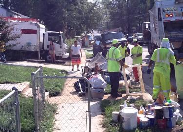
32 Recovery
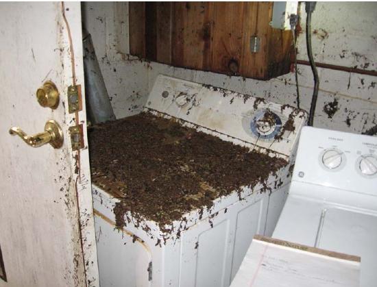
33 Recovery
34 Lesson 8 Debriefing & Revising the plan

35 Debriefing

36 Revising the Plan Revise Prediction Tools Post analysis: review data and compare these with our predicted outcomes Use these data to refine models The Flood Response Plan is revised annually in the fall after the end of hurricane season

37 Discussion / Questions?

38 Contact Information Donald Demetrius, PhD, P.E. Stormwater Planning Division, Department of Public Works and Environmental Services Government Center Parkway Suite 449 Fairfax, VA TTY 711 Camylyn Lewis, PE Office Cell:


39 September 8, 2011 Tower 424 in Reston at Richmond Highway and Lorton Road
40 September 8, 2011 Tower 424 in Reston at Richmond Highway and Lorton Road
41 Thank You.
United States Multi-Hazard Early Warning System
 United States Multi-Hazard Early Warning System Saving Lives Through Partnership Lynn Maximuk National Weather Service Director, Central Region Kansas City, Missouri America s s Weather Enterprise: Protecting
Hurricane Readiness for Coastal Communities
 Hurricane Readiness for Participant Guide Developed for: Federal Emergency Management Agency Emergency Management Institute 16825 South Seton Avenue Emmitsburg, MD 21727-8998 Developed by: C² Technologies,
An Overview of Operations at the West Gulf River Forecast Center Gregory Waller Service Coordination Hydrologist NWS - West Gulf River Forecast Center
 National Weather Service West Gulf River Forecast Center An Overview of Operations at the West Gulf River Forecast Center Gregory Waller Service Coordination Hydrologist NWS - West Gulf River Forecast
Pompton Lakes Dam Downstream Effects of the Floodgate Facility. Joseph Ruggeri Brian Cahill Michael Mak Andy Bonner
 Pompton Lakes Dam Downstream Effects of the Joseph Ruggeri Brian Cahill Michael Mak Andy Bonner ASFPM 2013: Overview Page 2 Overview Page 3 Overview Page 4 Overview Page 5 Overview - Historical Pompton
Speakers: NWS Buffalo Dan Kelly and Sarah Jamison, NERFC Jeane Wallace. NWS Flood Services for the Black River Basin
 Speakers: NWS Buffalo Dan Kelly and Sarah Jamison, NERFC Jeane Wallace NWS Flood Services for the Black River Basin National Weather Service Who We Are The National Oceanic and Atmospheric Administration
ICE STORM! a mini tabletop exercise for home care agencies
 1 ICE STORM! a mini tabletop exercise for home care agencies HCA Education and Research Winter 2010 2011 2 What is a tabletop exercise? People come together to review and discuss a hypothetical emergency
Background and Purpose of Meeting. River Towers Meeting. Flood Risk Management Study Alternatives Overview
 1 and Purpose of Meeting River Towers Meeting Flood Risk Management Study Alternatives Overview September 23, 2014 There is no "proposed" flood risk management solution for this area at this time Fairfax
Complete Weather Intelligence for Public Safety from DTN
 Complete Weather Intelligence for Public Safety from DTN September 2017 White Paper www.dtn.com / 1.800.610.0777 From flooding to tornados to severe winter storms, the threats to public safety from weather-related
Presented by Jerry A. Gomez, P.E. National Hydropower Association Northeast Regional Meeting - September 17, 2009
 Presented by Jerry A. Gomez, P.E. National Hydropower Association Northeast Regional Meeting - September 17, 2009 Defining Probable Maximum Precipitation (PMP) PMP is the theoretically greatest depth of
Chapter 5 CALIBRATION AND VERIFICATION
 Chapter 5 CALIBRATION AND VERIFICATION This chapter contains the calibration procedure and data used for the LSC existing conditions model. The goal of the calibration effort was to develop a hydraulic
Flash Flood Guidance System On-going Enhancements
 Flash Flood Guidance System On-going Enhancements Hydrologic Research Center, USA Technical Developer SAOFFG Steering Committee Meeting 1 10-12 July 2017 Jakarta, INDONESIA Theresa M. Modrick Hansen, PhD
THE FIRE AND RESCUE SERVICE S ROLE IN RESPONDING TO FLOODING DAVE RUSSEL ASSISTANT CHIEF FIRE OFFICER
 THE FIRE AND RESCUE SERVICE S ROLE IN RESPONDING TO FLOODING DAVE RUSSEL ASSISTANT CHIEF FIRE OFFICER RESPONDING TO FLOODING NATIONAL CONTEXT Fire and Rescue Services Act 2004: Power to respond to floods
Tracking Storm Tide and Coastal Flooding During Hurricane Matthew
 Tracking Storm Tide and Coastal Flooding During Hurricane Matthew Stephen Harden, Jeanne Robbins, and Eric Frantz U.S. Geological Survey, South Atlantic Water Science Center Presented to: WRRI Annual Conference
Progress Report. Flood Hazard Mapping in Thailand
 Progress Report Flood Hazard Mapping in Thailand Prepared By: Mr. PAITOON NAKTAE Chief of Safety Standard sub-beuro Disaster Prevention beuro Department of Disaster Prevention and Mitigation THAILAND E-mail:
Flood Scenario Worksheet
 Flood Scenario Worksheet Scenario adapted from: http://www.epa.gov/watersecurity/tools/trainingcd/simple/source/scenario-8/ssc8-0.pdf Simple Tabletop Exercise, Interdependency Natural Disaster Scenario,
HURRICANE MATTHEW A GIS PERSPECTIVE GLYNN COUNTY GIS
 HURRICANE MATTHEW A GIS PERSPECTIVE GLYNN COUNTY GIS Situation September 25 th October 9 th 2016 Hurricane Matthew tracked its way up the east coast bringing hurricane force winds and flooding from Haiti
Real-Time Flood Forecasting Modeling in Nashville, TN utilizing HEC-RTS
 Real-Time Flood Forecasting Modeling in Nashville, TN utilizing HEC-RTS Brantley Thames, P.E. Hydraulic Engineer, Water Resources Section Nashville District, USACE August 24, 2017 US Army Corps of Engineers
WINTER STORM Annex II
 WINTER STORM Annex II I. PURPOSE A. This annex has been prepared to ensure a coordinated response by state agencies to requests from local jurisdictions to reduce potential loss of life and to ensure essential
Climate Adaptation Challenges for Boston s Water and Sewer Systems
 National Association of Flood & Stormwater Management Agencies Climate Adaptation Challenges for Boston s Water and Sewer Systems John P Sullivan P.E. October 15,2014 Boston 1630 Boston 1630-2012 Boston
Use of Geospatial data for disaster managements
 Use of Geospatial data for disaster managements Source: http://alertsystemsgroup.com Instructor : Professor Dr. Yuji Murayama Teaching Assistant : Manjula Ranagalage What is GIS? A powerful set of tools
TXWARN Tabletop Exercise: Hurricane Helen
 TXWARN Tabletop Exercise: Hurricane Helen July 31, 2015 Administrative Details In-studio participants and remote participants Situation manual Evaluations Training hours 1 In Studio: Welcome and Introductions
CATEX Hurricane Zachary
 CATEX Hurricane Zachary EXERCISE, EXERCISE,EXERCISE East Coast CATEX Power Restoration Functional Exercise 2013 This document was prepared under a grant from FEMA's Grants Programs Directorate, U.S. Department
SITUATION REPORT #7 September 8 th, 2017
 MCO AIRPORT EMERGENCY OPERATIONS CENTER SITUATION REPORT #7 September 8 th, 2017 STATE OF FLORIDA REGION V FEMA REGION IV GENERAL INFORMATION Local State of Emergency Declaration Number: 17-235 Dated:
Savannah Harbor Expansion Project
 Savannah Harbor Expansion Project Evaluation of Hurricane Surge Impacts with Proposed Mitigation Plan December 2007 Introduction This report summarizes the results of hurricane surge impacts with implementation
Las Colonias Subdivision September 2010 Flood Study
 Las Colonias Subdivision September 2010 Flood Study Curtis Beitel, P.E., CFM Scott Muchard, P.E. Project Engineer William Badini, CFM Senior Meteorologist Location Map Background Los Colonias Subdivision
Coordinated Safety Messaging: An Integrated Approach. Matt Moreland FLGHC: Effective Messaging and Decision Support Services May 16, 2017
 Coordinated Safety Messaging: An Integrated Approach Matt Moreland FLGHC: Effective Messaging and Decision Support Services May 16, 2017 Question According to most meteorologists, how long should a weather
Arkansas-Red Basin River Forecast Center Operations. RRVA Conference Durant, OK 8/22/2013 Jeff McMurphy Sr. Hydrologist - ABRFC
 Arkansas-Red Basin River Forecast Center Operations RRVA Conference Durant, OK 8/22/2013 Jeff McMurphy Sr. Hydrologist - ABRFC NWS River Forecast Centers NWS Weather Forecast Offices Operations Staffing
Forecasting Flood Risk at the Flood Forecasting Centre, UK. Delft-FEWS User Days David Price
 Forecasting Flood Risk at the Flood Forecasting Centre, UK Delft-FEWS User Days 2012 David Price Overview of the Flood Forecasting Centre (FFC) What is the FFC? Partnership between the Met Office and Environment
2006 & 2007 Pre-Hurricane Scenario Analyses
 2006 & 2007 Pre-Hurricane Scenario Analyses Executive Summary May 2007 Page 1 OF X FOR OFFICIAL USE ONLY 4 Public Availability to be Determined Under 5 U.S.C. 552 NOTE: Limited Distribution. Release of
Like other coastal cities, Honolulu s
 Worst-Case Scenarios: Flooding and Evacuation Plans in Honolulu Karl Kim, Pradip Pant, Eric Yamashita Like other coastal cities, Honolulu s long-term viability depends on how well it can adapt to climate
Delaware River Flood Advisory Committee
 Delaware River Flood Advisory Committee A Partnership to Support Flood Mitigation Alan Tamm Pennsylvania Emergency Management Agency Bureau of Recovery and Mitigation atamm@state.pa.us Peter Gabrielsen
Strategic Planning of Tuvalu Meteorological Service
 WMO Regional Seminar on Enhancing Service Delivery by National Meteorological & Hydrological Services (NMHSs( NMHSs) ) in RA V Kuala Lumpur, Malaysia, 2 6 April 2007 Strategic Planning of Tuvalu Meteorological
13.2 USING VIRTUAL GLOBES TO IMPROVE SITUATIONAL AWARENESS IN THE NATIONAL WEATHER SERVICE
 13.2 USING VIRTUAL GLOBES TO IMPROVE SITUATIONAL AWARENESS IN THE NATIONAL WEATHER SERVICE Andy Foster* National Weather Service Springfield, Missouri* Keith Stellman National Weather Service Shreveport,
NOAA s National Weather Service Philadelphia/Mt. Holly NJ
 Next Briefing Package: Thursday, October 1, 2015 no later than 300 PM Hazards and Impacts: Overview: A dangerous weather pattern is developing for our region. Threats include very heavy rainfall, inland
Seeley Burn Scar SR-31, Region 4 UDOT Weather Response Summer 2013
 Seeley Burn Scar SR-31, Region 4 UDOT Weather Response Summer 2013 Seeley Burn Scar Information June 26 July 18, 2012 48,050 acres burned Lightning caused fire 8 miles of SR-31 impacted Huntington Creek
Hurricane Preparation and Recovery. October 11, 2011 Jon Nance, Chief Engineer, NCDOT
 Hurricane Preparation and Recovery October 11, 2011 Jon Nance, Chief Engineer, NCDOT North Carolina & Severe Weather Our state often bears the brunt of storms, which include: Ice storms Snow storms Heavy
Geospatial natural disaster management
 Geospatial natural disaster management disasters happen. are you ready? Natural disasters can strike almost anywhere at any time, with no regard to a municipality s financial resources. These extraordinarily
Aid to Critical Infrastructure and Key Resources During a Disaster. Pete Grandgeorge MidAmerican Energy Company
 Aid to Critical Infrastructure and Key Resources During a Disaster Pete Grandgeorge MidAmerican Energy Company MidAmerican Energy Company Approximately 3,000 employees and 100 staffed facilities 1.4 million
Hurricane Irma. City of Cocoa Beach September 8 12, 2017
 Hurricane Irma City of Cocoa Beach September 8 12, 2017 Monitoring prior to landfall Expected effects What happened What went well What didn t go well Changes and improvements After Action Outline Storm
Chapter 1 Overview of Maps
 Chapter 1 Overview of Maps In this chapter you will learn about: Key points when working with maps General types of maps Incident specific maps Map legend and symbols Map sources A map is a navigational
Miami-Dade County Overview
 Miami-Dade County Overview 2,000 square miles World s busiest cruise port 2.6 million residents Second busiest US airport for international travelers Gateway to the Caribbean and Latin America Natural
City of Madison Flooding Event AUGUST 20 TH, 2018-PRESENT
 City of Madison Flooding Event AUGUST 20 TH, 2018-PRESENT Presentation Overview Review of Flash Flooding and Flooding from High Lake Levels (August 20 th -Present) Lake Level Information Damages FEMA How
Basins-Level Heavy Rainfall and Flood Analyses
 Basins-Level Heavy Rainfall and Flood Analyses Peng Gao, Greg Carbone, and Junyu Lu Department of Geography, University of South Carolina (gaop@mailbox.sc.edu, carbone@mailbox.sc.edu, jlu@email.sc.edu)
CLARK COUNTY SCHOOLS
 CLARK COUNTY SCHOOLS TRANSPORTATION DEPARTMENT INCLEMENT WEATHER PLANS 2016-17 Paul Christy, Superintendent Donald Stump, Director of Operations Danny Fisher, Transportation Supervisor AUTHORIZED SCHOOL
TRWD Upper Trinity River Flood Operations Decision Support System
 TRWD Upper Trinity River Flood Operations Decision Support System TFMA 2012 Fall Conference Rockwall, Texas September 20, 2012 Presented by: Andrew Ickert, PE, CFM & Craig Ottman, PE, CFM (Halff Associates,
Floodplain Risk Management in Dungog after the April 2015 Super Storm. Presentation Outline
 Presentation Outline Floodplain Risk Management in after the April 2015 Super Storm Rohan Hudson, Royal HaskoningDHV FMA 2017 Preparing for the Next Great Flood 17th May 2017 Background and Flood Mechanisms
Solution: The ratio of normal rainfall at station A to normal rainfall at station i or NR A /NR i has been calculated and is given in table below.
 3.6 ESTIMATION OF MISSING DATA Data for the period of missing rainfall data could be filled using estimation technique. The length of period up to which the data could be filled is dependent on individual
NOAA s National Weather Service Philadelphia/Mt. Holly NJ
 Next Briefing Package: Friday, October 2, 2015 no later than 300 PM Hazards and Impacts: Overview: A dangerous weather pattern still threatens our region. Threats include very heavy rainfall, inland river
USING GIS TO MODEL AND ANALYZE HISTORICAL FLOODING OF THE GUADALUPE RIVER NEAR NEW BRAUNFELS, TEXAS
 USING GIS TO MODEL AND ANALYZE HISTORICAL FLOODING OF THE GUADALUPE RIVER NEAR NEW BRAUNFELS, TEXAS ASHLEY EVANS While the state of Texas is well-known for flooding, the Guadalupe River Basin is one of
SITUATION REPORT. Hurricane Nate. Operational Period: October 8, to October 9,
 SITUATION REPORT Hurricane Nate Operational Period: October 8, 2017 0800 to October 9, 2017 0759 CURRENT SITUATION 2:00 p.m. Briefing Hurricane Nate WEATHER SUMMARY All watches and warnings discontinued.
City of Saginaw Right of Way Division Snow and Ice Removal Policy January 18, 2016
 Snow and Ice Removal Policy January 18, 2016 It is the policy of the to provide snowplowing and ice removal services in order to: Provide safe traveling conditions for motorists and pedestrians Assist
Severe Storm Response Version # 1-0-1
 Severe Storm Response Version # 1-0-1 Weather Warnings Environment Canada issues severe weather warnings, watches and advisories Weather Watch Severe weather may develop. Weather Warning Severe weather
UDOT Weather Program Traffic Operations Center
 UDOT Weather Program Traffic Operations Center Presentation Goals You MUST account for weather in your Traffic Management program Provide you with information on proven tools and strategies You NEED a
Using Operating Experience to Prevent or Mitigate Nuclear Events. What Is, Was and Will Be Available
 Using Operating Experience to Prevent or Mitigate Nuclear Events What Is, Was and Will Be Available Introduction Remember, it is by understanding the lessons learned from past events that we can adequately
Hydrological forecasting and decision making in Australia
 Hydrological forecasting and decision making in Australia Justin Robinson, Jeff Perkins and Bruce Quig Bureau of Meteorology, Australia The Bureau's Hydrological Forecasting Services Seasonal Forecasts
WEATHER SYSTEMS IMPACTING THE CAYMAN ISLANDS Prepared by the staff of the Cayman Islands National Weather Service
 WEATHER SYSTEMS IMPACTING THE CAYMAN ISLANDS 2008 Prepared by the staff of the Cayman Islands National Weather Service TROPICAL STORM DOLLY Formed 194 miles west of Grand Cayman July 19 th. The tropical
National Symposium on Extreme Weather Event Impacts on Transportation Infrastructure
 National Symposium on Extreme Weather Event Impacts on Transportation Infrastructure May 22, 2013 Extreme Winter Lake Effect Operations and Maintenance Gregory C. Johnson, PE Chief Operations Officer Michigan
2017 Hurricane Season and Beyond
 2017 Hurricane Season and Beyond Ken Graham National Hurricane Center Building a Weather-Ready Nation Much of U.S. Coast Saw Tropical Wind Watches or Warnings 2017 Hurricane Season Facts and Figures 7th
Flood Forecasting Methodology in Alberta
 Flood Forecasting Methodology in Alberta Evan Friesenhan, M.Eng., P.Eng Alberta Environment and Sustainable Resource Development March 17, 2014 River Forecast Team Mandate To provide Albertans with information
Emergency Action Guidelines for NH 4-H Animal Events
 Emergency Action Guidelines for NH 4-H Animal Events Purpose: This plan outlines guidelines designed to help ensure NH 4-H Animal Events and Shows are prepared for emergencies and severe weather conditions.
An overview of the applications for early warning and mapping of the flood events in New Brunswick
 Flood Recovery, Innovation and Reponse IV 239 An overview of the applications for early warning and mapping of the flood events in New Brunswick D. Mioc 1, E. McGillivray 2, F. Anton 1, M. Mezouaghi 2,
OC Public Works El Niño Storm Preparation 2015
 OC Public Works El Niño Storm Preparation 2015 December 8, 2015 Overview About OC Public Works Storm Preparation Pre-Storm During Storm Post-Storm Storm Preparation Canyon and Burn Areas County Department
Hurricane Harvey Flood Emergency Response
 Hot Science - Cool Talk # 114 Hurricane Harvey Flood Emergency Response Dr. David Maidment September 14, 2018 Produced by and for Hot Science - Cool Talks by the Environmental Science Institute. We request
Exercise Brunswick ALPHA 2018
 ALPHA Exercise Brunswick ALPHA 2018 Who we are (our structure) What we do (our forecasts) How you can access the information Tropical cyclone information (basic) Overview of the products used for Exercise
Alignments of Master of Disaster (MoD) Lessons for Grades K-2 with the Next Generation Science Standards (NGSS) X X X X X X X X X X
 Lessons for Grades K-2 with the Next Generation Science Standards (NGSS) X X X X X X X X X X") Alignments of Master of Disaster (MoD) Lessons for Grades K-2 with the Next Generation Science Standards (NGSS) Relevant Next Generation Science Standards Performance Expectations* MoD Lesson Purpose K-PS2-1
Alignments of Master of Disaster (MoD) Lessons for Grades K-2 with the Next Generation Science Standards (NGSS) Relevant Next Generation Science Standards Performance Expectations* MoD Lesson Purpose K-PS2-1
Monte Carlo Simulations for Probabilistic Flood Hazard Assessment
 Monte Carlo Simulations for Probabilistic Flood Hazard Assessment Jemie Dababneh, Ph.D., P.E., 1 and Mark Schwartz, P.E. 1 1 RIZZO Associates, Monroeville, Pennsylvania Presentation to PSA 2017 International
HEC-HMS Lab 4 Using Frequency Storms in HEC-HMS
 HEC-HMS Lab 4 Using Frequency Storms in HEC-HMS Created by Venkatesh Merwade (vmerwade@purdue.edu) Learning outcomes The objective of this lab is to learn how HEC-HMS is used to determine design flow by
USGS Flood Inundation Mapping of the Suncook River in Chichester, Epsom, Pembroke and Allenstown, New Hampshire
 USGS Flood Inundation Mapping of the Suncook River in Chichester, Epsom, Pembroke and Allenstown, New Hampshire NH Water & Watershed Conference Robert Flynn, USGS NH-VT Water Science Center March 23, 2012
SPEARFISH FIRE DEPARTMENT POLICIES AND PROCEDURES
 SPEARFISH FIRE DEPARTMENT POLICIES AND PROCEDURES Page 1 of 5 Volume: Operation Section: 20.00 Number: 20.09 Subject: Weather Watches, Warnings, Advisory s and Spotter Activation Date Issued: 28 March
SNOW CONTROL OPERATIONS
 SNOW CONTROL OPERATIONS PUBLIC WORKS TEAM STREET MAINTENANCE DIVISION SNOW CONTROL OPERATIONS Standard Operating Procedures for Snow Removal Operations. 1. Plowing operations will be initiated when snow
Rainwater storage facilities
 Rainwater storage facilities Development of facilities for target rainfall Planned discharge in pump drainage areas City Yokohama Kawasaki Total Discharge area Tsuzuki Kouhoku Hokubu Kase Planned discharge
The Wind Hazard: Messaging the Wind Threat & Corresponding Potential Impacts
 The Wind Hazard: Messaging the Wind Threat & Corresponding Potential Impacts Scott Spratt Warning Coordination Meteorologist NWS Melbourne, FL David Sharp Science & Operations Officer NWS Melbourne, FL
A HURRICANE IS COMING. Presented by Atiba Upchurch Broward Emergency Management Division
 A HURRICANE IS COMING Presented by Atiba Upchurch Broward Emergency Management Division Mission Statement To safeguard the lives and property of the people of Broward County from major hazards and emergencies
Climate Change Impacts in Alaska: the Weather Perspective
 Climate Change Impacts in Alaska: the Weather Perspective September 18, 2007 NOAA s National Weather Service, Alaska Region James Partain, Chief Environmental and Scientific Services Division NOAA NWS
System Validation. SEEFFG Operations Workshop. Theresa M. Modrick, PhD Hydrologic Engineer Hydrologic Research Center
 SEEFFG Operations Workshop System Validation Theresa M. Modrick, PhD Hydrologic Engineer Hydrologic Research Center TModrick@hrcwater.org 09 May 2016 1 Fundamental Concepts for Flash Flood Guidance FFG
6/9/2014. Software Overview. System Overview
 Future Rainfall 6/9/2014 Curtis Beitel, PE, CFM, Anthony Henry and Wayne Tschirhart, PE, CFM, PMP TFMA Spring 2014 Conference Software Overview 2 Processes Hydrometric DB Event Manager Automatic Low =
University of Oklahoma Emergency Response Plan for INSERT EVENT NAME HERE.
 University of Oklahoma Emergency Response Plan for INSERT EVENT NAME HERE. Time/Date of Event: INSERT BOTH START & END TIME/DATE HERE. Location of Event: LIST ALL LOCATIONS HERE OF EVENT, INCLUDING ADDRESS.
THE IMPACT OF WEATHER
 The United States is the most severe weather prone country in the world. Each year, people in this country cope with an average of 10,000 thunderstorms, 5,000 floods, 1,200 tornadoes and two landfalling
Ground Water Protection Council 2017 Annual Forum Boston, Massachusetts. Ben Binder (303)
") Ground Water Protection Council 2017 Annual Forum Boston, Massachusetts Protecting Groundwater Sources from Flood Borne Contamination Ben Binder (303) 860-0600 Digital Design Group, Inc. The Problem Houston
Ground Water Protection Council 2017 Annual Forum Boston, Massachusetts Protecting Groundwater Sources from Flood Borne Contamination Ben Binder (303) 860-0600 Digital Design Group, Inc. The Problem Houston
Advanced Spotter Training Welcome! Lesson 1: Introduction and Why Spotters are Important
 Advanced Spotter Training 2009 Welcome! Lesson 1: Introduction and Why Spotters are Important Introduction This course is intended to advance the basic training given by the National Weather Service (NWS).
Trainee Manual C02 CITY OF SASKATOON. Water and Sewer Section. Severe Storm Response Trainee Manual. Version # 1-0-3
 Trainee Manual C02 CITY OF SASKATOON Water and Sewer Section Severe Storm Response Trainee Manual CITY OF SASKATOON Severe Storm Response Trainee Manual City of Saskatoon Severe Storm Response Trainees
Hydrology and Hydraulics Design Report. Background Summary
 To: National Park Services Montezuma Castle National Monument Richard Goepfrich, Facility Manager From: Multicultural Technical Engineers Date: Tuesday - February 13, 2018 Subject: 30% Hydrology and Hydraulics
Challenges in providing effective flood forecasts and warnings
 Challenges in providing effective flood forecasts and warnings National Centre for Flood Research Inaugural Symposium Justin Robinson Bureau of Meteorology October 2018 Zero Lives Lost A key responsibility
Memorandum. Background
 Memorandum To: Kevin Stewart, P.E., Information Systems & Flood Warning Program Manager From: Mark Mitisek, H.I.T. Reviewed by: Kelly Close, P.E. Date: 02/11/2013 Project: Boulder Creek Hydromodel Subject:
Managing an Extreme Weather Event of Prolonged Duration May 22, 2013
 Managing an Extreme Weather Event of Prolonged Duration May 22, 2013 MISSOURI RIVER FLOOD OF 2011 M I C H A E L J. K E N N E R L Y P. E. D I R E C T O R O F T H E O F F I C E O F D E S I G N I O W A D
STEUBEN COUNTY, NEW YORK. Hazard Analysis Report
 STEUBEN COUNTY, NEW YORK Hazard Analysis Report Prepared by: April 1, 2014 Background On April 1, 2014 the Steuben County Office of Emergency Management conducted a hazard analysis using the automated
Steering Committee on Global Flash Flood Guidance 29 November 2016, Inter-Continental Hotel, Phnom Penh. Cambodia National Weather Services
 Steering Committee on Global Flash Flood Guidance 29 November 2016, Inter-Continental Hotel, Phnom Penh Cambodia National Weather Services Activities and Responsibilities of Research and Flood Forecasting
Final Report. COMET Partner's Project. University of Texas at San Antonio
 Final Report COMET Partner's Project University: Name of University Researcher Preparing Report: University of Texas at San Antonio Dr. Hongjie Xie National Weather Service Office: Name of National Weather
Regional Flash Flood Guidance and Early Warning System
 WMO Training for Trainers Workshop on Integrated approach to flash flood and flood risk management 24-28 October 2010 Kathmandu, Nepal Regional Flash Flood Guidance and Early Warning System Dr. W. E. Grabs
Robert Shedd Northeast River Forecast Center National Weather Service Taunton, Massachusetts, USA
 Robert Shedd Northeast River Forecast Center National Weather Service Taunton, Massachusetts, USA Outline River Forecast Centers FEWS Implementation Status Forcing Data Ensemble Forecasting The Northeast
CHARLEVILLE FLOOD MANAGEMENT MOVING BEYOND PHYSICAL MITIGATION N Polglase 1, D Murray 2 1 Murweh Shire Council, Charleville, QLD
 CHARLEVILLE FLOOD MANAGEMENT MOVING BEYOND PHYSICAL MITIGATION N Polglase 1, D Murray 2 1 Murweh Shire Council, Charleville, QLD 2 CDM Smith, Brisbane, QLD Introduction Charleville is a major regional
f<~~ ~ Gulf Power April16, 2018
 ~ Gulf Power Rhonda J. Alexander One Energy Place I 1anage' Pensacola. ~l 32520-0780 Regulatory Fooecastmg & Procong 850 444 67,13 tel 850.:144 6026 fax r jale>xad @~out her nro com April16, 2018 Ms. Carlotta
Technical Memorandum No
 Pajaro River Watershed Study in association with Technical Memorandum No. 1.2.10 Task: Evaluation of Four Watershed Conditions - Sediment To: PRWFPA Staff Working Group Prepared by: Gregory Morris and
Areal Reduction Factors for the Colorado Front Range and Analysis of the September 2013 Colorado Storm
 Areal Reduction Factors for the Colorado Front Range and Analysis of the September 2013 Colorado Storm Doug Hultstrand, Bill Kappel, Geoff Muhlestein Applied Weather Associates, LLC - Monument, Colorado
教育啓蒙への利活用を考慮した防災技術情報アーカイブシステムの開発 (2013)
") Title Program 1 : Preparedness Program fo Impact Author(s) SOE, Aye Aye Citation 教育啓蒙への利活用を考慮した防災技術情報アーカイブシステムの開発 (2013) Issue Date 2013-06 URL http://hdl.handle.net/2433/175523 Right Type Article Textversion
Title Program 1 : Preparedness Program fo Impact Author(s) SOE, Aye Aye Citation 教育啓蒙への利活用を考慮した防災技術情報アーカイブシステムの開発 (2013) Issue Date 2013-06 URL http://hdl.handle.net/2433/175523 Right Type Article Textversion
Prepared by: Ryan Ratcliffe GPH-903 December 10, 2011
 Prepared by: Ryan Ratcliffe GPH-903 December 10, 2011 Scientific studies have proven that global sea level has risen 7.1 inches in the past century and computer models have suggested that climate change
Formulation of the Strategy for Disaster Risk Reduction and Emergency Preparedness and Response of the Asia-Pacific Region
 2008/SOM3/TFEP/SEM/006 Formulation of the Strategy for Disaster Risk Reduction and Emergency Preparedness and Response of the Asia-Pacific Region 2009-2015 Submitted by: Thailand Emergency Management CEOs
National Public Weather and Warning Services in the Swaziland Meteorological Service Dennis S.Mkhonta /
 National Public Weather and Warning Services in the Swaziland Meteorological Service Dennis S.Mkhonta dennis.mkhonta@gmail.com / dennis@swazimet.gov.sz Introduction Swaziland s geographical position exposes
The NOAA/NWS Warning Decision Training Branch (WDTB): On-line Training Resources for Emergency Managers & Intro to Dual-Polarization Radar
: On-line Training Resources for Emergency Managers & Intro to Dual-Polarization Radar") The NOAA/NWS Warning Decision Training Branch (WDTB): On-line Training Resources for Emergency Managers & Intro to Dual-Polarization Radar Andy Wood CIMMS (University of Oklahoma)/ WDTB (NOAA/NWS) The
The NOAA/NWS Warning Decision Training Branch (WDTB): On-line Training Resources for Emergency Managers & Intro to Dual-Polarization Radar Andy Wood CIMMS (University of Oklahoma)/ WDTB (NOAA/NWS) The
GIS: a common operational picture for public safety and emergency management
 Safety and Security Engineering IV 455 GIS: a common operational picture for public safety and emergency management J. Perdikaris School of Engineering, University of Guelph, Canada Abstract Not so long