CATEX Hurricane Zachary
|
|
|
- Pamela Turner
- 5 years ago
- Views:
Transcription

1 CATEX Hurricane Zachary EXERCISE, EXERCISE,EXERCISE East Coast CATEX Power Restoration Functional Exercise 2013 This document was prepared under a grant from FEMA's Grants Programs Directorate, U.S. Department of Homeland Security. Points of view or opinions expressed in this document are those of the authors and do not necessarily represent the official position or policies of FEMA's Grants Programs Directorate or the U.S. Department of Homeland Security.
2 Exercise overview The East Coast CATEX Power Restoration 2013 Functional Exercise is sponsored by the FEMA Region 3 states (VA, DC, WV, MD, DE & PA) through the Regional Catastrophic Preparedness Grant Program (RCPGP). This Participant Guide was produced with input, advice, and assistance from the Exercise Planning Team, which followed guidance set forth by the U.S. Department of Homeland Security (DHS) Homeland Security Exercise and Evaluation Program (HSEEP). The East Coast CATEX Power Restoration is designed to establish a learning environment for players to exercise emergency response plans, policies, and procedures as they pertain to a Hurricane. A Hurricane is a complex event that requires detailed planning. To ensure an effective exercise, subject matter experts (SMEs) and local representatives from numerous agencies have taken part in the planning process and will take part in exercise conduct and evaluation. This Participant Guide was produced with input, advice, and assistance from the East Coast CATEX Power Restoration Exercise Planning Team. This exercise is evidence of the growing public safety partnership between State and local jurisdictions regarding the response to the threat of Hurricane that our Nation and communities face.
3 Concept and Objectives 1. Fleet Movement Coordination/Reconciliation: Demonstrate the ability to support/reconcile (pre-stage, react, and recover) Power Sector Fleet movement requirements (before, during, and after) a catastrophic event. a. Evaluate the role of the Electric Utility Liaison Officer (ELO): Based on the ESF 12 ELO job description working group and current roles of the ELO, evaluate the effectiveness of the product and the operational use. b. Operational Information Flow: Using centralized frameworks of information to provide real time, relevant, usable and coordinated information across both private and public sectors, to evaluate operational information flow. 2. Regional Transportation Management: Demonstrate the capability of RITIS to support the movement of the supply chain to facilitate continuity of regular commerce (along the edge of the catastrophic zone) during an evacuation event.
4 Admin instructions All spoken and written communications will start and end with the statement EXERCISE, EXERCISE, EXERCISE For an emergency that requires assistance, use the phrase real-world emergency. Each State, Private Sector and Cell location will control entry to exercise venues. Participate in the Hot Wash at your facility with controllers and evaluators. Complete the Participant Feedback Form. This form allows you to comment candidly on emergency response activities and exercise effectiveness. Provide the completed form to a controller or evaluator.
5 Exercise Schedule Personnel [Oct 28, 2013] Controllers, evaluators, and Exercise Planning Team members Controller and Evaluator Briefing Private sector electric utility companies and public sector Participant Brief All Document Distribution Oct 29, Selected controllers and exercise staff members Exercise site setup 0715 Controllers and evaluators Check-in/virtual 0715 Participants (players, observers, actors) Registration 0730 Controllers and evaluators Commo check 0730 Participants Participant briefings 0800 All Start of exercise (StartEx) 0800 Private sector electric utility companies and public sector Participant Brief 1600 All End of exercise (EndEx) Immediately following EndEx Participants, controllers, and evaluators Hot Wash (individually conducted by location) Oct 30, Controllers, evaluators, and Exercise Planning Team members Controller and Evaluator Debriefing

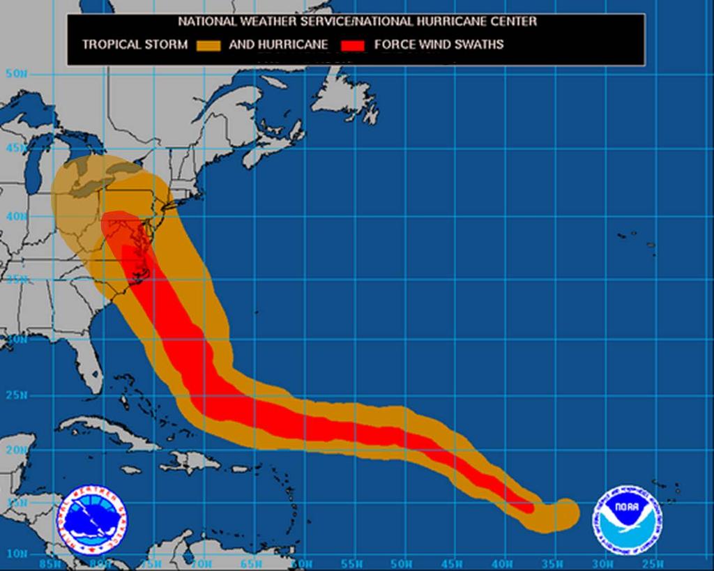
6 Scenario The National Weather Service issued a Hurricane Watch for all counties in Maryland, Virginia, Delaware, Washington DC, West Virginia, and Pennsylvania. Hurricane Zachary was located about 600 miles south-southeast of Cape Hatteras, North Carolina, moving North- Northwest at 8 mph. The estimated minimum central pressure is 959 MB with maximum sustained winds of 105 MPH with higher gusts, making Zachary a category two hurricane. The storm will make landfall in 72 hrs.
7 H-72 HURRICANE ZACHARY LOCAL STATEMENT NATIONAL WEATHER SERVICE BALTIMORE MD/WASHINGTON DC DATE/TIME: H-48...A HURRICANE WATCH IS IN EFFECT FOR ALL COUNTIES IN MARYLAND, VIRGINIA, DELAWARE, WASHINGTON DC, WEST VIRGINIA, AND PENNSYLVANIA. AT 11 AM EDT HURRICANE ZACHARY WAS LOCATED NEAR 27.4 NORTH LATITUDE AND 71.2 WEST LONGITUDE OR ABOUT 600 MILES SOUTH-SOUTHEAST OF CAPE HATTERAS NORTH CAROLINA...MOVING NORTH NORTHWEST AT 8 MPH. ESTIMATED MINIMUM CENTRAL PRESSURE IS 959 MB WITH MAXIMUM SUSTAINED WINDS OF 105 MPH WITH HIGHER GUSTS. THIS MAKES ZACHARY A CATEGORY TWO HURRICANE....PREPAREDNESS ACTIONS... PERSONS LOCATED IN AND NEAR THE POSTED HURRICANE WATCH AREA SHOULD PREPARE FOR HIGH WINDS AND SIGNIFICANT COASTAL FLOODING. PEOPLE INLAND SHOULD PREPARE FOR STRONG WINDS...HEAVY RAIN...AND POTENTIAL SMALL STREAM AND RIVER FLOODING....RAINFALL AND INLAND FLOODING... RAINFALL TOTALS OF 3 TO 6 INCHES ARE EXPECTED IN THE BALTIMORE - WASHINGTON AREA...OVER THE CHESAPEAKE BAY AND ACROSS SOUTHERN MARYLAND. FOR THE PIEDMONT AND MOUNTAIN AREAS OF MARYLAND...VIRGINIA AND WEST VIRGINIA AND PENNSYLVANIA AND DELAWARE...RAINFALL TOTALS OF 6 TO 10 INCHES ARE POSSIBLE WITH ISOLATED AMOUNTS OF 12 INCHES OR MORE. THIS COULD CAUSE SERIOUS FLASH FLOODING AND MUDSLIDES WITH POTENTIALLY MAJOR FLOODING OF SOME RIVERS....STORM SURGE...WAVES AND TIDAL FLOODING... THE THREAT OF STORM SURGE WILL BE ON THE INCREASE LATE THURSDAY NIGHT INTO EARLY FRIDAY. ALONG THE WESTERN SHORE OF THE CHESAPEAKE BAY TIDAL SURGES OF 3 TO 5 FEET ARE POSSIBLE. THIS SURGE WOULD BE ON TOP OF THE NORMAL TIDE AND THEN WAVES OF 4 TO 5 FEET MAY OCCUR ON TOP OF THAT. ALONG THE NORTH SHORE OF THE TIDAL POTOMAC IN CHARLES AND ST MARYS COUNTIES A STORM SURGE OF 4 TO 6 FEET IS POSSIBLE. THE REMAINDER OF THE TIDAL POTOMAC COULD SEE SURGES OF 3 TO 5 FEET....WIND INFORMATION... TROPICAL STORM FORCE WINDS OF 40 TO 60 MPH WILL BEGIN AFFECTING SOUTHERN MARYLAND MIDDAY THURSDAY AND WILL SPREAD INLAND THROUGH THE AFTERNOON AND EVENING. STRONGER WIND GUSTS TO HURRICANE FORCE WILL BE POSSIBLE THURSDAY NIGHT INTO FRIDAY MORNING AS THE CENTER OF THE STORM PASSES. THESE WINDS MAY CAUSE DAMAGE TO TREES AND UTILITY LINES. THE NATIONAL WEATHER SERVICE ADVISES RESIDENTS IN THE AFFECTED AREA TO CONTINUE MONITORING NOAA WEATHER RADIO AND THE MEDIA FOR UPDATES ON HURRICANE ZACHARY. ADDITIONAL INFORMATION CAN ALSO BE FOUND ON OUR WEBSITE:
8 H-72
9 H-72
GC Briefing. Weather Sentinel Tropical Storm Michael. Status at 8 AM EDT (12 UTC) Today (NHC) Discussion. October 11, 2018
 Today (NHC) Discussion. October 11, 2018") GC Briefing Weather Sentinel Tropical Storm Michael October 11, 2018 After making landfall as a high-end category-4 hurricane on the Florida Panhandle, Michael weakened to tropical storm status early this
GC Briefing Weather Sentinel Tropical Storm Michael October 11, 2018 After making landfall as a high-end category-4 hurricane on the Florida Panhandle, Michael weakened to tropical storm status early this
NWS HURRICANES June 3, 2015
 NWS HURRICANES June 3, 2015 Hurricane Season June 1 November 30 2 What s the concern? All tropical systems passing within 125nm of central Maryland since 1950 Mid-Atlantic Hurricanes Greatest Risk: August
Major Hurricane Earl
 Major Hurricane Earl Advisory 32 North Carolina Threat Assessment Prepared at: 8 AM Thursday September 2, 2010 Hurricane and Tropical Storm Warnings in effect for the North Carolina Coast and Sounds. NWS
Major Hurricane Matthew Briefing Situation Overview
 Major Hurricane Matthew Briefing Situation Overview THIS IS NOW A WORST CASE STORM SURGE SCENARIO Catastrophic Damage is Anticipated for Coastal Areas. Major Hurricane Matthew is still expected to move
Major Hurricane Earl
 Major Hurricane Earl Advisory 33 North Carolina Threat Assessment Prepared at: 11 AM Thursday September 2, 2010 Hurricane and Tropical Storm Warnings in effect for the North Carolina Coast and Sounds NWS
NOAA s National Weather Service Philadelphia/Mt. Holly NJ
 Next Briefing Package: Friday, October 2, 2015 no later than 300 PM Hazards and Impacts: Overview: A dangerous weather pattern still threatens our region. Threats include very heavy rainfall, inland river
Hurricane Sandy October 28 th 31 st 2012
 Hurricane Sandy October 28 th 31 st 2012 Prepared 530 PM EDT Saturday October 27, 2012 Gary Szatkowski NOAA s NJ Forecast Office Weather.gov/phi Purpose of Briefing Briefing #7 for event Promote situational
Very Dangerous Coastal Storm Sandy October 28 th 31 st 2012
 Very Dangerous Coastal Storm Sandy October 28 th 31 st 2012 Prepared 600 PM EDT Monday October 29, 2012 Gary Szatkowski NOAA s NJ Forecast Office Weather.gov/phi Purpose of Briefing Briefing #11 for event
GC Briefing. Weather Sentinel Hurricane Florence. Status at 5 PM EDT (21 UTC) Today (NHC) Discussion. September 13, 2018
 Today (NHC) Discussion. September 13, 2018") GC Briefing September 13, 2018 Weather Sentinel Hurricane Florence Tropical storm conditions have been reported for areas of North Carolina and will continue to spread inland to the west and south. Hurricane
GC Briefing September 13, 2018 Weather Sentinel Hurricane Florence Tropical storm conditions have been reported for areas of North Carolina and will continue to spread inland to the west and south. Hurricane
NOAA s National Weather Service Philadelphia/Mt. Holly NJ
 Next Briefing Package: Thursday, October 1, 2015 no later than 300 PM Hazards and Impacts: Overview: A dangerous weather pattern is developing for our region. Threats include very heavy rainfall, inland
Hurricane Matthew. Life Threatening Flash Flooding Likely. National Weather Service Wilmington NC. Josh Weiss, Meteorologist
 Hurricane Matthew Life Threatening Flash Flooding Likely Threat Assessment for northeast South Carolina & southeast North Carolina National Weather Service Wilmington NC 630 PM EDT Friday October 7, 2016
WEDNESDAY 30 TH AUGUST, :57 p.m. Tropical Storm Irma forms in the Atlantic. Don t let your guard down, always #Be Ready.
 Chapter 1 - The Set Up In the days leading up to Irma a series of composed and sobering text messages, presented in truncated form below, from Department of Disaster Management warned us of the pending
Subtropical Storm Ana
 Subtropical Storm Ana Threat Assessment for northeast South Carolina & southeast North Carolina Created 745 AM Fri May 8, 2015 Reid Hawkins, Science Officer National Weather Service Wilmington, NC 1 New
Weather Briefing Mixed Winter Storm Event February 26-27, 2013
 Weather Briefing Mixed Winter Storm Event February 26-27, 2013 Prepared 1200 PM EST Tuesday, February 26th, 2013 Joe Miketta NOAA s NJ Forecast Office http://www.erh.noaa.gov/phi/ Purpose of Briefing Briefing
Hurricane Matthew Life Threatening Flash Flooding Likely
 Hurricane Matthew Life Threatening Flash Flooding Likely Threat Assessment for northeast South Carolina & southeast North Carolina National Weather Service Wilmington NC 12 AM EDT Saturday October 8, 2016
TXWARN Tabletop Exercise: Hurricane Helen
 TXWARN Tabletop Exercise: Hurricane Helen July 31, 2015 Administrative Details In-studio participants and remote participants Situation manual Evaluations Training hours 1 In Studio: Welcome and Introductions
Tropical Update. 11 AM EDT Wednesday, October 10, 2018 Hurricane Michael, Hurricane Leslie & Tropical Storm Nadine, Caribbean Low (40%)
") Tropical Update 11 AM EDT Wednesday, October 10, 2018 Hurricane Michael, Hurricane Leslie & Tropical Storm Nadine, Caribbean Low (40%) This update is intended for government and emergency response officials,
Tropical Update 11 AM EDT Wednesday, October 10, 2018 Hurricane Michael, Hurricane Leslie & Tropical Storm Nadine, Caribbean Low (40%) This update is intended for government and emergency response officials,
Weather briefing Strong Coastal Nor easter November 7 th -8 th, 2012
 Weather briefing Strong Coastal Nor easter November 7 th -8 th, 2012 Prepared 1215 PM EDT Wednesday November 7, 2012 Gary Szatkowski NOAA s NJ Forecast Office http://www.erh.noaa.gov/phi/ Purpose of Briefing
Major Hurricane Matthew Briefing Situation Overview
 Major Hurricane Matthew Briefing Situation Overview At 5 p.m. Tuesday, Category 4 Hurricane Matthew was about 860 miles South-Southeast of Mayport, Florida, moving north around 10 mph. Maximum sustained
Hurricane Matthew Threats and Impacts Briefing for Eastern NC
 Hurricane Matthew Threats and Impacts Briefing for Eastern NC October 6 th, 2016 Date/Time Created: 10/6/2016, Noon EDT National Weather Service Newport/Morehead City, NC Hurricane Matthew Key Points Changes
Hurricane Readiness for Coastal Communities
 Hurricane Readiness for Participant Guide Developed for: Federal Emergency Management Agency Emergency Management Institute 16825 South Seton Avenue Emmitsburg, MD 21727-8998 Developed by: C² Technologies,
HURRICANE IRENE. CONFERENCE CALL BRIEFING SLIDES Saturday August 27, :30 AM
 HURRICANE IRENE CONFERENCE CALL BRIEFING SLIDES Saturday August 27, 2011 8:30 AM NHC TRACK AND CONE HURRICANE IRENE WATCHES/WARNINGS Hurricane Warning along south coast including all of Cape Cod and Islands
Tropical Update. 11 AM EDT Tuesday, October 9, 2018 Hurricane Michael, Tropical Storm Leslie, Tropical Storm Nadine
 Tropical Update 11 AM EDT Tuesday, October 9, 2018 Hurricane Michael, Tropical Storm Leslie, Tropical Storm Nadine This update is intended for government and emergency response officials, and is provided
Coastal Storm Potential
 Coastal Storm Potential Event Date/Time: 11/12/2009-11/14/2009 Today through Saturday National Weather Service Newport/Morehead City, NC Date: 11/12/2009 1000 am Coastal Storm Remnants of Ida, coupled
A Prepared Marylander Creates a Resilient Maryland
 Maryland Emergency Management Agency Operations Directorate Hazardous Winter Weather Outlook Briefing March 5, 2013 0800 A Prepared Marylander Creates a Resilient Maryland A strong low pressure will track
Tropical Update. 12 PM EDT Friday, October 7, 2016 Hurricane Matthew & Tropical Storm Nicole
 Tropical Update 12 PM EDT Friday, October 7, 2016 Hurricane Matthew & Tropical Storm Nicole This update is intended for government and emergency response officials, and is provided for informational and
Weather briefing Strong Coastal Nor easter November 7 th -8 th, 2012
 Weather briefing Strong Coastal Nor easter November 7 th -8 th, 2012 Prepared 1245 PM EDT Tuesday November 6, 2012 Gary Szatkowski NOAA s NJ Forecast Office Weather.gov/phi Purpose of Briefing Briefing
Active Weather Threat Halloween Week Nor easter October 28 th 31 st 2012
 Active Weather Threat Halloween Week Nor easter October 28 th 31 st 2012 Prepared 1130 AM EDT Wednesday, October 24, 2012 Gary Szatkowski NOAA s NJ Forecast Office Weather.gov/phi Purpose of Briefing Briefing
photo courtesy of
 BRITISH VIRGIN ISLANDS REPORT TROPICAL STORM JEANNE photo courtesy of www.bviplatinum.com PREPARED BY THE DEPARTMENT OF DISASTER MANAGEMENT 1 EVENT 13 th -16 th September, 2004 TROPICAL STORM JEANNE Sequence
Hurricane Irma Page 1 HURRTRAK RM/Pro 2017 Summary Report for Tampa, FL 09/09/ EDT, Adv. # 43
 Hurricane Irma Page 1 Description of impact to Tampa, FL, Tampa, FL, is expected to receive a major impact from Hurricane Irma. The forecast maximum wind for this location has decreased since the last
SITUATION REPORT #7 September 8 th, 2017
 MCO AIRPORT EMERGENCY OPERATIONS CENTER SITUATION REPORT #7 September 8 th, 2017 STATE OF FLORIDA REGION V FEMA REGION IV GENERAL INFORMATION Local State of Emergency Declaration Number: 17-235 Dated:
Hurricane Irma Page 1 HURRTRAK RM/Pro 2017 Summary Report for Tampa, FL 09/10/ EDT, Adv. # 46
 Hurricane Irma Page 1 Description of impact to Tampa, FL, Tampa, FL, is expected to receive a major impact from Hurricane Irma. The forecast maximum wind for this location has increased since the last
Wind field has expanded and is very large. Hurricane Wind field = 100 miles wide, Tropical Storm Wind field = 360 miles wide
 HURRICANE IRMA 12 PM ET Sunday, September 10 2017 Prepared by: Keith Stellman / Kyle Thiem www.weather.gov/atlanta/briefings @NWSAtlanta www.weather.gov/atlanta Situation Overview 11:10 AM EDT Sun Sep
NOAA s National Weather Service Philadelphia/Mt. Holly NJ. Summary. Changes
 Summary A crippling and potentially historic east coast snow storm will lead to blizzard conditions and major coastal flooding for portions of the area this weekend. Changes Blizzard Warning has been expanded
Tropical Update. 5 PM EDT Sunday, September 10, 2017 Hurricane Irma, Hurricane Jose, Tropical Wave (60%)
") Tropical Update 5 PM EDT Sunday, September 10, 2017 Hurricane Irma, Hurricane Jose, Tropical Wave (60%) This update is intended for government and emergency response officials, and is provided for informational
Tropical Update 5 PM EDT Sunday, September 10, 2017 Hurricane Irma, Hurricane Jose, Tropical Wave (60%) This update is intended for government and emergency response officials, and is provided for informational
Coastal Storm this Weekend
 Weather Briefing Prepared 9 AM EST Feb 5, 2010 Joe Miketta Warning Coordination Meteorologist NOAA s National Weather Service Philadelphia/Mt. Holly NJ Forecast Office 609-261 261-6602 6602 x223 Joseph.Miketta@noaa.gov
TROPICAL STORM NATE BRIEFING
 TROPICAL STORM NATE BRIEFING 5:00 AM CDT Friday, October 6, 2017 Prepared by: NWS NWSNewOrleans www.weather.gov/neworleans Situation Overview No significant changes to the track forecast this morning.
Nor easter Monday Night Wednesday December 8 10, 2014
 Nor easter Monday Night Wednesday December 8 10, 2014 Prepared 400 PM EST Monday, December 8, 2014 Mitchell Gaines NOAA s Philadelphia/Mount Holly NJ Forecast Office www.weather.gov/phi/ Purpose of Briefing
Tropical Weather Briefing
 Tropical Weather Briefing August 28, 2012 700 AM CDT National Weather Service Weather Forecast Office Slidell, LA Current Satellite Tropical Storm Isaac Watches/Warnings Tropical Storm Isaac Track Guidance
A HURRICANE IS COMING. Presented by Atiba Upchurch Broward Emergency Management Division
 A HURRICANE IS COMING Presented by Atiba Upchurch Broward Emergency Management Division Mission Statement To safeguard the lives and property of the people of Broward County from major hazards and emergencies
Tropical Storm Ana. Created 6:00 AM Sun May 10, 2015 John Cole Warning Coordination Meteorologist
 Tropical Storm Ana Threat Assessment for Eastern North Carolina Created 6:00 AM Sun May 10, 2015 John Cole Warning Coordination Meteorologist John.cole@noaa.gov National Weather Service Newport/Morehead
Hurricane Harvey: SE Texas Impacts. 10 PM CDT UPDATE Friday, August 25, 2017 Prepared by: Lance Wood
 Hurricane Harvey: SE Texas Impacts 10 PM CDT UPDATE Friday, August 25, 2017 Prepared by: Lance Wood Latest Observations Hurricane Harvey making landfall this evening near Rockport as a category 4 hurricane.
Tropical Storm Harvey: SE Texas Impacts
 Tropical Storm Harvey: SE Texas Impacts 10 AM CDT UPDATE Thursday, August 24, 2017 Prepared by: Dan Reilly, Brian Kyle PLEASE MUTE YOUR LINES AND DON T PUT ON HOLD! Situation Overview Tropical Storm Harvey
Tropical Activity. Atlantic Hurricane Florence (CAT 4)
") Tropical Activity Atlantic Hurricane Florence (CAT 4) Located 530 miles southeast of Cape Fear, NC Moving WNW at 17 mph; maximum sustained winds 130 mph Expected to slow down considerably by late Thursday
Tropical Activity Atlantic Hurricane Florence (CAT 4) Located 530 miles southeast of Cape Fear, NC Moving WNW at 17 mph; maximum sustained winds 130 mph Expected to slow down considerably by late Thursday
Significant Coastal Storm Today through Thursday, 11/7-8. Weather Briefing
 Significant Coastal Storm Today through Thursday, 11/7-8 Weather Briefing Prepared 10:00 am EST Wednesday, November 7, 2012 Presented by Gary Conte, Warning Coordination Meteorologist NOAA s National Weather
Tropical Update 6 AM EDT Friday, October 7, 2016 Hurricane Matthew & Hurricane Nicole
 Tropical Update 6 AM EDT Friday, October 7, 2016 Hurricane Matthew & Hurricane Nicole This update is intended for government and emergency response officials, and is provided for informational and situational
Storm Surge Forecast with Shifting Forecast Tracks
 Storm Surge Forecast with Shifting Forecast Tracks Storm Surge Findings in the Florida Keys Jon Rizzo Warning Coordination Meteorologist National Weather Service Florida Keys Florida Keys Life History
Tropical Storm Ana. Created 615 AM Sat May 9, 2015 Reid Hawkins, Science Officer
 Tropical Storm Ana Threat Assessment for northeast South Carolina & southeast North Carolina Created 615 AM Sat May 9, 2015 Reid Hawkins, Science Officer National Weather Service Wilmington, NC 1 New Information
Daily Operations Briefing. Sunday, October 5, :30 a.m. EDT
 Daily Operations Briefing Sunday, October 5, 2014 8:30 a.m. EDT Significant Activity: Oct 4-5 Significant Events: Typhoon 19W (Vongfong) Tropical Activity: Atlantic Tropical Cyclone Activity is not expected
Tropical Storm Isaac. INFORMATION NOTE No. 3 AS OF 8:00 PM (AST) ON SEPTEMBER 12, Synopsis of Tropical Storm Isaac
 ON SEPTEMBER 12, Synopsis of Tropical Storm Isaac") Synopsis of Tropical Storm Isaac LOCATION: 260 MILES EAST NORTH EAST OF MARTINIQUE PRESENT MOVEMENT: WEST AT 20 MPH MAXIMUM SUSTAINED WINDS: 60 MPH MINIMUM CENTRAL PRESSURE: 1003 MB WATCHES AND WARNINGS
Synopsis of Tropical Storm Isaac LOCATION: 260 MILES EAST NORTH EAST OF MARTINIQUE PRESENT MOVEMENT: WEST AT 20 MPH MAXIMUM SUSTAINED WINDS: 60 MPH MINIMUM CENTRAL PRESSURE: 1003 MB WATCHES AND WARNINGS
Prolonged Coastal Storm October 9 th -12 th, 2013
 Prolonged Coastal Storm October 9 th -12 th, 2013 Prepared 400 PM EDT Tuesday, October 8th, 2013 Gary Szatkowski NOAA s NJ Forecast office http://www.erh.noaa.gov/phi/ Purpose of Briefing Briefing #1 for
HURRICANE IRMA. 12 PM ET Saturday, September Prepared by: Kyle Thiem / Sid King.
 HURRICANE IRMA 12 PM ET Saturday, September 9 2017 Prepared by: Kyle Thiem / Sid King www.weather.gov/atlanta/briefings @NWSAtlanta www.weather.gov/atlanta Situation Overview 11:00 AM EDT Sat Sep 9 Location:
Tropical Update. 5 PM EDT Tuesday, September 5, 2017 Hurricane Irma, Tropical Storm Jose, and Tropical Depression Thirteen
 Tropical Update 5 PM EDT Tuesday, September 5, 2017 Hurricane Irma, Tropical Storm Jose, and Tropical Depression Thirteen This update is intended for government and emergency response officials, and is
Hurricane Harvey: SE Texas Impacts. 10 AM CDT UPDATE Saturday, August 26, 2017 Prepared by: Dan Reilly, Brian Kyle
 Hurricane Harvey: SE Texas Impacts 10 AM CDT UPDATE Saturday, August 26, 2017 Prepared by: Dan Reilly, Brian Kyle Latest Observations and Radar Hurricane Harvey centered near Victoria and weakening Wind
Key Takeaways: - Rain: Coastal NC: ; isolated totals to 40 Central, Western, & Northeastern NC: 5-10 ; isolated totals to 20
 Key Takeaways: - Life-Threatening Impacts Will Extend Far From The Storm s Center: Despite the southward shift in track, widespread and extreme impacts from heavy rain, storm surge, and wind are still
Current Details from the National Hurricane Center (NHC)
") Current Watches/Warnings A Hurricane Warning is in effect from Surf City, North Carolina to the North Carolina/Virginia border; Pamlico Sound; Eastern Albemarle Sound A Hurricane Watch is in effect from
Current Watches/Warnings A Hurricane Warning is in effect from Surf City, North Carolina to the North Carolina/Virginia border; Pamlico Sound; Eastern Albemarle Sound A Hurricane Watch is in effect from
Tropical Update. 5 AM EDT Tuesday, September 12, 2017 Post-Tropical Cyclone Irma, Hurricane Jose, & Tropical Wave (10%)
") Tropical Update 5 AM EDT Tuesday, September 12, 2017 Post-Tropical Cyclone Irma, Hurricane Jose, & Tropical Wave (10%) This update is intended for government and emergency response officials, and is provided
Tropical Update 5 AM EDT Tuesday, September 12, 2017 Post-Tropical Cyclone Irma, Hurricane Jose, & Tropical Wave (10%) This update is intended for government and emergency response officials, and is provided
Tropical Storm Colin Briefing Last Briefing on this System
 Tropical Storm Colin Briefing Last Briefing on this System NWS WFO Jacksonville, Florida Tuesday, June 07, 2016 6:00 a.m. EDT Tropical Storm Colin s Impacts SE Georgia & North Florida Local Watches & Warnings:
Tropical Update. 5 AM EDT Wednesday, September 6, 2017 Hurricane Irma, Tropical Storm Jose, and Tropical Storm Katia
 Tropical Update 5 AM EDT Wednesday, September 6, 2017 Hurricane Irma, Tropical Storm Jose, and Tropical Storm Katia This update is intended for government and emergency response officials, and is provided
September 13, 2018 MEDIA RELEASE. Waynesboro Department of Emergency Management Waynesboro Police Department Waynesboro Fire Department
 MEDIA RELEASE September 13, 2018 The City continues to prepare for and monitor the track and potential impacts of Hurricane Florence. Current guidance from the National Weather Service, the National Hurricane
Tornado Drill Exercise Plan (EXPLAN)
") Tornado Drill Exercise Plan (EXPLAN) As part of the National Weather Service s (NWS) Severe Weather Preparedness Week in Indiana Purdue University March 19, 2019 As of Feb 19, 2019 TABLE OF CONTENTS Introduction...
Tornado Drill Exercise Plan (EXPLAN) As part of the National Weather Service s (NWS) Severe Weather Preparedness Week in Indiana Purdue University March 19, 2019 As of Feb 19, 2019 TABLE OF CONTENTS Introduction...
Massachusetts Department of Public Health Emergency Preparedness Bureau. August 27, hrs
 Massachusetts Department of Public Health Emergency Preparedness Bureau August 27, 2011 1500 hrs Health and Medical Situational Awareness Report: Hurricane Irene Situational Awareness Report: Hurricane
Tropical Update. 5 AM EDT Thursday, September 7, 2017 Hurricane Irma, Hurricane Jose, and Hurricane Katia
 Tropical Update 5 AM EDT Thursday, September 7, 2017 Hurricane Irma, Hurricane Jose, and Hurricane Katia This update is intended for government and emergency response officials, and is provided for informational
Monday, October 8, :30 a.m. EDT
 Monday, October 8, 2018 8:30 a.m. EDT Significant Activity Oct 7-8 Significant Events: Tropical Storm Michael Preparation Tropical Activity: Atlantic Tropical Storm Leslie; Tropical Storm Michael; Disturbance
Tropical Update. 5 PM EDT Thursday, September 7, 2017 Hurricane Irma, Hurricane Jose, and Hurricane Katia
 Tropical Update 5 PM EDT Thursday, September 7, 2017 Hurricane Irma, Hurricane Jose, and Hurricane Katia This update is intended for government and emergency response officials, and is provided for informational
NOAA s National Weather Service Philadelphia/Mt. Holly NJ
 Snow and Coastal Flooding through this evening Hazards and Impacts: Coastal Flooding: With the persistent onshore flow, and a new moon yesterday, coastal flooding is expected at high tide today. Moderate
Hurricane Matthew. National Weather Service Wilmington NC. Steven Pfaff, WCM.
 Hurricane Matthew Threat Assessment for northeast South Carolina & southeast North Carolina National Weather Service Wilmington NC 730 AM EDT Tuesday October 4, 2016 Steven Pfaff, WCM Steven.Pfaff@noaa.gov
Storm Summary for Hurricane Joaquin
 Storm Summary for Hurricane Joaquin Wednesday, September 30, 2015 at 5 PM EDT (Output from Hurrevac, based on National Hurricane Center Forecast Advisory #12) Joaquin is currently a Category 1 hurricane
Hurricane Preparation and Recovery. October 11, 2011 Jon Nance, Chief Engineer, NCDOT
 Hurricane Preparation and Recovery October 11, 2011 Jon Nance, Chief Engineer, NCDOT North Carolina & Severe Weather Our state often bears the brunt of storms, which include: Ice storms Snow storms Heavy
United States Multi-Hazard Early Warning System
 United States Multi-Hazard Early Warning System Saving Lives Through Partnership Lynn Maximuk National Weather Service Director, Central Region Kansas City, Missouri America s s Weather Enterprise: Protecting
TROPICAL STORM NATE BRIEFING
 TROPICAL STORM NATE BRIEFING 10:30 AM CDT Friday, October 06, 2017 Prepared by: NWS NWSNewOrleans www.weather.gov/neworleans Situation Overview Track forecast has shifted slightly eastward. Hurricane Watch
Tropical Cyclone Isaac (AL092012)
") Tropical Cyclone Isaac (AL092012) Event Briefing, Central Caribbean Impacts Caribbean Risk Managers Ltd Facility Supervisor 27 August 2012 Facility Supervisor: Caribbean Risk Managers Ltd Email: ccrif@ccrif.org
Tropical Cyclone Isaac (AL092012) Event Briefing, Central Caribbean Impacts Caribbean Risk Managers Ltd Facility Supervisor 27 August 2012 Facility Supervisor: Caribbean Risk Managers Ltd Email: ccrif@ccrif.org
Weather Briefing for Pennsylvania Feb Outlook Prepared 02/11/14 2 pm EST
 Weather Briefing for Pennsylvania Feb. 12-13 Outlook Prepared 02/11/14 2 pm EST Prepared by: National Weather Service State College, PA (Peter.Jung@noaa.gov) Pennsylvania Weather Overview A significant
Hurricane Matthew Page 1 Location Forecast Analysis Summary Report - Advanced Wind Estimation On
 Page 1 Current NHC Forecast Predictions Maximum Sustained Winds / Storm Category: 138 MPH / Category 4 Forward motion: 9 mph towards the North Hurricane Force winds extend from the center: 46 miles Tropical
National Situation Report As of 3:00 a.m. EDT, Monday, October 2, 2017 Table of Contents Current Operations Monitoring Recovery
 Overview National Situation Report As of 3:00 a.m. EDT, Monday, October 2, 2017 Table of Contents Current Operations Monitoring Recovery FEMA Headquarters Status FEMA Region Status NRCC Level I (24/7)
Are You Ready For Hurricane Season? 2018 Hurricane Talk B Y : S T O R M T E A M 8 M E T E O R O L O G I S T J U L I E P H I L L I P S
 Are You Ready For Hurricane Season? 2018 Hurricane Talk B Y : S T O R M T E A M 8 M E T E O R O L O G I S T J U L I E P H I L L I P S About Me I am Currently a Weekday Meteorologist at WFLA Channel 8.
Tropical Activity. Atlantic Hurricane Florence (CAT 4)
") Tropical Activity Atlantic Hurricane Florence (CAT 4) As of 8 a.m. ET Tuesday, Florence's center had maximum sustained winds of 130 mph and was about 950 miles east-southeast of Cape Fear, North Carolina.
Tropical Activity Atlantic Hurricane Florence (CAT 4) As of 8 a.m. ET Tuesday, Florence's center had maximum sustained winds of 130 mph and was about 950 miles east-southeast of Cape Fear, North Carolina.
Wednesday, October 24, :30 a.m. EDT
 Wednesday, October 24, 2018 8:30 a.m. EDT Tropical Outlook Western Pacific Tropical Cyclone Yutu (CAT 5) (Advisory #12 as of 5:00 a.m. EDT) 85 miles SE of Tinian Maximum sustained winds 165 mph; moving
Significant Flooding Expected
 Significant Flooding Expected Decision Support Briefing #5 As of: 9:00 AM September 14, 2018 What Has Changed? Flash Flood Watch now in effect for part of area, will be expanded later today 9/14/2018 9:23
HURRICANE NATE BRIEFING
 HURRICANE NATE BRIEFING 2:00 PM CDT Saturday, October 07, 2017 Prepared by: NWS NWSNewOrleans www.weather.gov/neworleans Situation Overview continues to intensify. It is now forecast to be a category 2
Communications and Lessons Learned from
 Weather Forecast Office Charleston, SC Communications and Lessons Learned from Southeast and Caribbean and Climate Community of Practice - April, 2017 Public Information and Communications During Extremes
WEATHER SYSTEMS IMPACTING THE CAYMAN ISLANDS Prepared by the staff of the Cayman Islands National Weather Service
 WEATHER SYSTEMS IMPACTING THE CAYMAN ISLANDS 2008 Prepared by the staff of the Cayman Islands National Weather Service TROPICAL STORM DOLLY Formed 194 miles west of Grand Cayman July 19 th. The tropical
HURRICANE HARVEY COE Navigation BRIEFING
 HURRICANE HARVEY COE Navigation BRIEFING 10:00 AM CDT Friday, August 25, 2017 NWSNewOrleans www.weather.gov/neworleans Situation Overview New Information Harvey continues to strengthen Max sustained winds
TROPICAL STORM HARVEY COE Navigation Call - Update
 TROPICAL STORM HARVEY COE Navigation Call - Update 10:00 AM CDT Tuesday, August 29, 2017 Prepared by: NWS LIX NWSNewOrleans www.weather.gov/neworleans Situation Overview New Information Drifting ENE at
Hurricane Matthew. National Weather Service Wilmington NC. Steven Pfaff, WCM.
 Hurricane Matthew Threat Assessment for northeast South Carolina & southeast North Carolina National Weather Service Wilmington NC 515 PM EDT Monday October 3, 2016 Steven Pfaff, WCM Steven.Pfaff@noaa.gov
Table-Top Exercise for Emergency Preparedness Evaluation: Little Anse, Isle Madame
 Table-Top Exercise for Emergency Preparedness Evaluation: Little Anse, Isle Madame Alexander Chung, M.Sc. Candidate C-Change Student Research Associate May 2013 The Community of Little Anse Coastal community
Tropical Update. 5 PM EDT Thursday, August 27, 2015 Tropical Storm Erika
 Tropical Update 5 PM EDT Thursday, August 27, 2015 Tropical Storm Erika This update is intended for government and emergency response officials, and is provided for informational and situational awareness
TROPICAL STORM NATE BRIEFING
 TROPICAL STORM NATE BRIEFING 2:00 PM CDT Friday, October 06, 2017 Prepared by: NWS NWSNewOrleans www.weather.gov/neworleans Situation Overview Track forecast has not changed since the 10 am advisory. Hurricane
Saturday, October 6, :30 a.m. EDT
 Saturday, October 6, 2018 8:30 a.m. EDT Significant Activity Oct 5-6 Significant Events: None Tropical Activity: Atlantic Tropical Storm Leslie; Disturbance 1 (High: 90%) Eastern Pacific Hurricane Sergio
The Wind Hazard: Messaging the Wind Threat & Corresponding Potential Impacts
 The Wind Hazard: Messaging the Wind Threat & Corresponding Potential Impacts Scott Spratt Warning Coordination Meteorologist NWS Melbourne, FL David Sharp Science & Operations Officer NWS Melbourne, FL
Daily Operations Briefing. Sunday, October 19, :30 a.m. EDT
 Daily Operations Briefing Sunday, October 19, 2014 8:30 a.m. EDT Significant Activity: Oct 18-19 Significant Events: Hurricane Ana Tropical Activity: Atlantic Hurricane Gonzalo (FINAL) Eastern Pacific
Current Details from the National Hurricane Center (NHC)
") Current Watches and Warnings A Hurricane Warning is in effect from South Santee River, South Carolina (SC) to Duck, North Carolina (NC); Albemarle and Pamlico Sounds A Hurricane Watch is in effect from
Current Watches and Warnings A Hurricane Warning is in effect from South Santee River, South Carolina (SC) to Duck, North Carolina (NC); Albemarle and Pamlico Sounds A Hurricane Watch is in effect from
National Situation Report As of 3:00 a.m. EDT, Thursday, September 21, 2017 Table of Contents Current Operations Monitoring Recovery
 25k Overview National Situation Report As of 3:00 a.m. EDT, Thursday, September 21, 2017 Table of Contents Current Operations Monitoring Recovery FEMA Headquarters Status FEMA Region Status NRCC Level
Business Preparedness. Hurricane Preparedness 2018 NFP InForum February 15, 2018
 Business Preparedness Hurricane Preparedness 2018 NFP InForum February 15, 2018 Agenda Past Experience Hugo Floyd Matthew Irma Hurricane Tabletop Exercise Pre-Landfall Post-Landfall (1 day and 10 days)
2006 & 2007 Pre-Hurricane Scenario Analyses
 2006 & 2007 Pre-Hurricane Scenario Analyses Executive Summary May 2007 Page 1 OF X FOR OFFICIAL USE ONLY 4 Public Availability to be Determined Under 5 U.S.C. 552 NOTE: Limited Distribution. Release of
WHAT HAPPENS WHEN A TORNADO STRIKES THE COMMUNITY? Carroll County Sheriff s Office Emergency Management
 WHAT HAPPENS WHEN A TORNADO STRIKES THE COMMUNITY? Carroll County Sheriff s Office Emergency Management WHAT IS EMERGENCY MANAGEMENT? Carroll County Sheriff s Office Emergency Management Agency is responsible
WEATHER NOTIFICATION STATEMENT
 WEATHER NOTIFICATION STATEMENT NEW DATA SHOWS SNOWSTORM THREAT FOR JAN 13-14 LOOKS MUCH HEAVIER BIGGER COVERAGE northwest NC (ice) ALL OF VA (Except Hampton Roads) all of MD/ DEL eastern southern PA southern
NOAA s National Weather Service Philadelphia/Mt. Holly NJ
 Early Week Coastal Flooding and snow Hazards and Impacts: Coastal Flooding: With the persistent onshore flow, and a new moon today, coastal flooding is expected at high tide through Tuesday morning. Moderate
City of Punta Gorda Community Emergency Management Plan 2013
 City of Punta Gorda Community Emergency Management Plan 2013 Hurricane Andrew- August 24, 1992 Category 5 hurricane. The second-most-destructive hurricane in U.S. history. The first named storm of the